Embed Size (px)
Citation preview
������������� ���������
ENVIRONMENTAL SCOPING REPORT
40 MW Oyster Wave Array
West Coast Lewis
May 2011

40MW Oyster Wave Array, West Coast Lewis
Page 2 of 106
����������������
��������������������������������������� �����!"�����!!#�

40MW Oyster Wave Array, West Coast Lewis
Page 3 of 106
���������� ����� ����������
#�#� �$� %������$�������������������������������������������������������������������������������������������������"�#�&� ���'���������(��(���������������������������������������������������������������������������������������������������������"�#�)� ���'���������������$����*�����*�$�����+����������������������������������������������������������������##�
�� ��������� ����������������
&�#� �����$��������%,����(�,�(�������$�����������������������������������������������������������������������������#-�&�&� ��%(��$�(���$��������������������������������������������������������������������������������������������������������#-�&�)� �������$��(�%����(�,���������������������������������������������������������������������������������������������������&!�&�.� �����������+$�(�����%(��$�(���������������������������������������������������������������������������������������&#�
�� ������������������������
)�#� �$�(����*,�(�$������������$���%������*���%,������������������������������������������������������������&&�)�&� ��������($��%����%,�$���*,�����%,�����������������������������������������������������������������������������&.�)�)� �$����$������(�����/�$�(�,����������������������������������������������������������������������������������������&"�
�� ��������������������������
.�#� �����%(�$�����(%�$�����(��������������������������������������������������������������������������������������������&0�
.�&� ����*(�������%,����������������������������������������������������������������������������������������������������������)&�
.�)� ��������($��$���(�����(�$�������%,�������������������������������������������������������������������������������)1�
.�.� ���(�*���%,���������������������������������������������������������������������������������������������������������������)0�
.�1� �$�(����$��$����������������������������������������������������������������������������������������������������������.)�
.�"� �(�*�$����*����(�*��������������������������������������������������������������������������������������������������."�
�� ������������������� ����������
1�#� ��$��$��2��$����$���$���+(��$��$���(�,������������������������������������������������������������������������10�1�&� �������($���(�*��(�����������������������������������������������������������������������������������������������������"#�1�)� �*(��(�%�$����$+(%$�(������������������������������������������������������������������������������������������������"1�1�.� ���*������$��(��$�����$������������������������������������������������������������������������������������������"0�1�1� �(�(�$�,�$��(+(�,���������������������������������������������������������������������������������������������������������-!�1�"� $��*$����%,�$���������$��*��(�$%������������������������������������������������������������������������������-&�1�-� ���*������(��������������������������������������������������������������������������������������������������������������-0�1�3� ����(���$��������$�(������������������������������������������������������������������������������������������������3!�1�0� ���(��������(�����������������������������������������������������������������������������������������������������������3#�1�#!� �����$�(+��������������������������������������������������������������������������������������������������������������3)�
�� ���������������
�� �������������������
-�#� �($�������������������������������������������������������������������������������������������������������������������������0#�-�&� �������$�(������$��%,������������������������������������������������������������������������������������������������01�-�)� �(�(%$�(���$������(���(�%�����������������������������������������������������������������������������������������0-�
�� ��������!�������������
3�#� ����(�%�/����(��������$�����$ �*��������������(����������������������������������������������������������03�
�� �� ������������
"� ����� ������"��

40MW Oyster Wave Array, West Coast Lewis
Page 4 of 106
����������$��$� $ 45��6�7�46����8�9�����������:��
$����$��� $7 ����:���:���:�� ���:��;���66����4�:���;��5���6��4�:���� �5�����
�$�� ������ ���<�$4���:��6:�
�%�� � ����5�%��6�7�46��= �<�
�(���� �5����:�:���:��:�(:�� :���:6�� ����:��:�:7� ����>�4�����;���6���=:�:��
�6� �
��$� ����6�� ���4���:�$4��
�($� �:� �:��:�6���>4���������:��
����� �= �>�:�� �:���:� 7<�4�:� ��
��� �:� �:��:��������:��
���$� �����:���:� �:��:�6�� ���4���:�$4��
%���� %�:� 6���:��:7��=6���
*�9� �:�� *�9 ���:�� �:���:� 7<��=�= ���� �?�4��
*��� *<� ���6�4� �4��6:��
*%+� *�<�%�����+�5�46��
(���� �5��(:�� :���:6���=:4�6��� ��5���@>6� ���:��;��5�����
(�$� (:����=����;��:� �:��:�6�$�������:��
(���� (:����=����;��4�6�7<�$:���:� �:��:�6��:7���:��
'�$��� '��:���=��46�$ 45��6�7<���6�4<�����������
���� ��46����6�>��:���6:��
��$� � ������$:������7= ��$7�:4<�� �� �:����:�=6����:�$ ��
����� ��:�������� ��> �:7�
������� � �:���4��6:��A���4�:4���
��� ��7����B�:����66��:�����C�
���� ����:6������� ���<������ 8�
���� ����:6���75�5�=����� ��
���� ����:6��6::�:7�� ���� 8�
��$� ��7���:����8�$�������:��
���$�� ��6��� �����:�:���:2���7:����:�#00&�9<�������9� �������;� ��5��� ���4���:��;�
�5��� �:���:� �:��:���;��5���� �5�����$�6:��4��
�$�� �6::�:7�$��4�������
��D$� � 4��4��$:���@� 4����$ ��B��6�� <C�
�*$� � �6���: <�*E ��$�������:��
���� �=96�4�� ��4�>���:��� �4����
���� ���� ��8���;;�
��$*��� ��<6����������:��:��5��$:4��:��:��*���� �46���:=��:����;��4��6:��

40MW Oyster Wave Array, West Coast Lewis
Page 5 of 106
���(� ��<6�����:6���;�9���(:����=���
�,$� ��<6�,45��:7�$���4����:�
�$�� �>�4�6�$ ���;���:�� ���:�
�$�� �45��=6���$:4��:����:=��:��
����� �5���>�4�6������������:���6��
���$� �4�����5��:� �:��:��� ���4���:�$7�:4<�
��+($� ���4>�2��:��4>��:��+��=6�(�>4��$�������:��
��*� �4�����5���= 6�*� ��7��
��$� �>�4�6�� ���4����$ ��
���(� ������;��>�4�6��4��:��;�4�(:�� ����
+��� +����6���:��� �:7��<�����
���� ����:� 7<���:� �� �
�
40MW Oyster Wave Array, West Coast Lewis
Page 6 of 106
1. INTRODUCTION
1.1 Background and Document Purpose
This Scoping Report has been prepared by Royal Haskoning for Lewis Wave Power Limited. Lewis Wave Power is seeking to develop a 40 MW wave energy demonstration array off the west coast of the Isle of Lewis, Scotland. The proposed development will deploy Oyster Wave Energy Converters (WECs) with an installed capacity of approximately 1 MW each.
This Scoping Report supports a request for a formal scoping opinion from Marine Scotland, who will in turn consult with the relevant competent authorities and key statutory consultees.
This report represents the first stage of the Environmental Impact Assessment (EIA) process and has been produced to facilitate the identification and assessment of the potential environmental impacts associated with the project.
The objectives of this report are:
� Describe the proposed development;
� Identify and summarise the known baseline environmental conditions on site;
� Identify the environmental constraints and benefits associated with the development;
� Consider potential environmental impacts which may arise from the development;
� Identify further studies which may be required to fulfil EIA requirements; and
� Identify the most appropriate approach to studies and subsequent impact evaluation.
� Inform consultees of Lewis Wave Power’s proposals and invite opinion.
Note to reader: All place names within this report have been referenced from Ordnance Survey maps 1:50,000 unless they are included on a published list in which case the anglicised name may be referred to.
Lewis Wave Power welcomes your comments on this Scoping Document, particularly information on data available, and advice on how best to involve stakeholders during the Environmental Impact Assessment process. Comments can be emailed to [email protected]; please mark the subject line “Lewis Scoping Report”. 1.2 Project Description
1.2.1 Lewis Wave Power
Lewis Wave Power Limited is a wholly owned subsidiary of Edinburgh based Aquamarine Power, the technology developer of the Oyster wave power technology, which captures energy from near shore waves and converts it into clean sustainable electricity.
40MW Oyster Wave Array, West Coast Lewis
Page 7 of 106
The first full-scale 315kW Oyster was officially launched by Scotland’s First Minister Alex Salmond at the European Marine Energy Centre (EMEC) in Orkney in November 2009, when it began producing power to the National Grid for the first time. That device has withstood a full winter in the harsh Atlantic waters off the coast of the Orkney Islands in northern Scotland.
Aquamarine Power is now developing the next generation 2.4 MW Oyster 2, which is scheduled to commence deployment at EMEC in 2011. The Oyster 2 project will consist of three WECs, high and low pressure transmission pipelines back to shore, and a single onshore hydro-electric plant (HEP) with two drive trains. The system will have a total rating of 2.4 MW (or 800kW for each device).
Aquamarine Power is currently performing early engineering for the third generation Oyster 3 installation, which it is anticipated will be deployed in Lewis. Oyster 3 will consist of a number of WECs installed in phases over several summer seasons from 2013 onwards. Oyster 3 will implement the same Oyster 2 array concept, but at a much larger scale with more WECs, and will be the first commercial Oyster development.
1.2.2 Oyster Technology
Oyster consists of a simple steel oscillating WEC, the flap, which is fitted with double acting hydraulic pistons. The device is mounted on the seabed in depths of 10 to 20m, such that it completely penetrates the water column. Each passing wave activates the device; which delivers high pressure water (freshwater) via a sub-sea pipeline to the shore. Onshore, high-pressure water is converted to electrical power using proven, conventional Pelton wheel and hydro-electric generators. The flow from the Pelton wheel discharges to a header tank and returns to the device via a low pressure return pipeline.
The Oyster concept has a number of major advantages:
� Oyster is designed to produce clean, renewable electricity from energy captured from near shore waves.
� Environmental considerations are paramount in Oyster design, development, installation, operation and maintenance. The system is a closed loop via an offshore device(s) with minimal seabed footprint.
� All electro-mechanical power generation equipment is located onshore, reducing the cost of maintenance and increasing availability.
� Multiple devices can be manifolded to a single pipeline and hydro electric power conversion plant (HEP), allowing the concept to take full advantage of potential economies of scale.
� The device is located in the near shore region where wave energy is more predictably directional. The water depth and wave breaking environment reduce the occurrence of extreme wave heights when compared to offshore, but without any significant reduction in the overall wave energy available.
40MW Oyster Wave Array, West Coast Lewis
Page 8 of 106
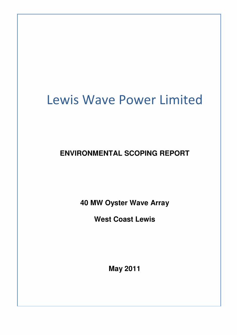
Figure 1.1 (a) & (b) Oyster 1 full scale device in operation / fabrication
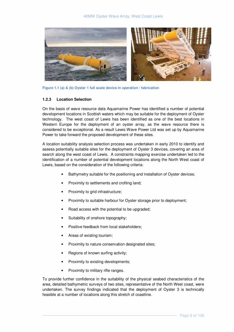
1.2.3 Location Selection
On the basis of wave resource data Aquamarine Power has identified a number of potential development locations in Scottish waters which may be suitable for the deployment of Oyster technology. The west coast of Lewis has been identified as one of the best locations in Western Europe for the deployment of an oyster array, as the wave resource there is considered to be exceptional. As a result Lewis Wave Power Ltd was set up by Aquamarine Power to take forward the proposed development of these sites.
A location suitability analysis selection process was undertaken in early 2010 to identify and assess potentially suitable sites for the deployment of Oyster 3 devices, covering an area of search along the west coast of Lewis. A constraints mapping exercise undertaken led to the identification of a number of potential development locations along the North West coast of Lewis, based on the consideration of the following criteria:
• Bathymetry suitable for the positioning and installation of Oyster devices;
• Proximity to settlements and crofting land;
• Proximity to grid infrastructure;
• Proximity to suitable harbour for Oyster storage prior to deployment;
• Road access with the potential to be upgraded;
• Suitability of onshore topography;
• Positive feedback from local stakeholders;
• Areas of existing tourism;
• Proximity to nature conservation designated sites;
• Regions of known surfing activity;
• Proximity to existing developments;
• Proximity to military rifle ranges.
To provide further confidence in the suitability of the physical seabed characteristics of the area, detailed bathymetric surveys of two sites, representative of the North West coast, were undertaken. The survey findings indicated that the deployment of Oyster 3 is technically feasible at a number of locations along this stretch of coastline.
40MW Oyster Wave Array, West Coast Lewis
Page 9 of 106
Further investigations into the bathymetric and environmental conditions along the Outer Hebrides coast are planned by the Hebridean Marine Energy Futures (HebMarine) project over the next 3 years. The HebMarine is a collaborative research programme, aimed at enabling the Western Isles to become a real centre of expertise in wave energy, lead by the University of the Highlands and Islands in Lews Castle College. Aquamarine Power is the lead industry partner for the HebMarine project.
1.2.4 Development Area/ Area of Search
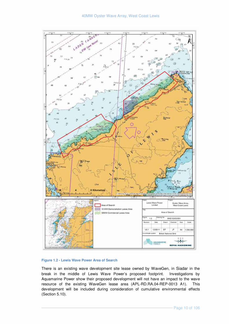
The Crown Estate granted Lewis Wave Power two seabed lease options for the North West coast of Lewis on the 19th May 2011 (shown in Figure 1.2). The first lease option consists of a 10 MW Demonstration lease area to the north of Siadar; the second lease option is a commercial 30 MW lease covering an area of search stretching from Bàgh Dhail Beag in the south to Tràigh Shanndaigh in the north. This scoping report scopes an area which contains both lease areas and is termed the “area of Search” (Figure 1.2).
It is important to note that the granting of a lease option area does not give the holder unlimited development access across the whole option area. Instead the lease option agreement allows the developer time and security to undertake research and gain consent for a development somewhere within the lease option area. Once development consent is obtained, the development area subject to the consent is turned into a seabed lease. It is anticipated that the development will lead to a total cumulative development area of 2 km along the coastline. The proposed wave array will have an installed capacity of 40 MW and could provide enough energy to power 38,000 homes.
40MW Oyster Wave Array, West Coast Lewis
Page 10 of 106
Figure 1.2 - Lewis Wave Power Area of Search
There is an existing wave development site lease owned by WaveGen, in Siadar in the break in the middle of Lewis Wave Power’s proposed footprint. Investigations by Aquamarine Power show their proposed development will not have an impact to the wave resource of the existing WaveGen lease area (APL-RD.RA.04-REP-0013 A1). This development will be included during consideration of cumulative environmental effects (Section 5.10).
40MW Oyster Wave Array, West Coast Lewis
Page 11 of 106
1.3 Project Components and the Rochdale Envelope
The Oyster device is undergoing commercial demonstration trials in Orkney and information from these trials will inform the final design of Oyster 3; the device which will be installed at the Lewis site.
Lewis Wave Power proposes taking a ‘Rochdale Envelope’ approach during the EIA to address elements of uncertainty within the project description. The project description provided below presents a series of maximum extents or magnitudes for key aspects of the proposed project, for which the significance of environmental effects will be assessed during the EIA. Using this approach it is anticipated that detailed design of the project or scheme could vary within specific parameters described without rendering the basis for the EIA inadequate.
The Rochdale approach has been applied to: structural components of the development (e.g. maximum flap size); operational parameters (e.g. noise emission); physical footprint (e.g. number of devices); array1 layout and design; alternative locations for ancillary structures, grid connection options; and choices over installation and deployment methods. There are clear difficulties in undertaking an accurate EIA if the parameters of the envelope are too flexible / too broad; and consequently Lewis Wave Power will define a more detailed project description prior to commencement of EIA, following initial site investigation and device engineering works.
There is limited guidance on the application of the Rochdale Envelope approach in the consenting of marine renewables in Scotland and Lewis Wave Power would welcome the views of regulatory bodies on its proposed approach.
1.3.1 Site Layout and Components
The project or scheme will consist of 40 devices in an ‘array’ producing up to 40 MW located in 8-15m water depth. Lewis Wave Power proposes phasing installation as follows:
� Phase 1: Three devices (installed 2013);
� Phase 2: Seven devices (installed 2014);
� Phase 3: Fifteen devices (installed 2015; and
� Phase 4: Fifteen devices (installed 2016).
Environmental impacts of the proposed development will be assessed, based on current knowledge, however, it is fully appreciated that the technology proposed remains novel and that understanding of its interaction with the marine environment, particularly in an array, is incomplete. Aquamarine Power has already learned from its deployment of Oyster 1 at the European Marine Energy Centre (EMEC) wave testing site in Billa Croo, Orkney. In addition an environmental monitoring programme will be implemented as part of the testing of the Oyster 2 (next generation) device as an array of 3, in Orkney over the next 2 years.
Monitoring before, during and after installation of each phase is planned, and the results will improve understanding of the interactions of an array of devices with physical processes and
1 The term “array” refers to a group of oyster devices

40MW Oyster Wave Array, West Coast Lewis
Page 12 of 106
natural heritage. A design review is also planned during each installation period, allowing lessons learned to be applied to subsequent phases.
Devices will be installed on the seabed and partially submerged in operation, with the upper 3m of the devices protruding above the sea surface (relative to Mean Sea Level (MSL)). There will be a minimum separation between devices of at least 10m, with exact array layout and device dimensions informed by a range of factors including technology development, hydraulic modelling, analysis of site survey, and other environmental data. It is intended that a 25m separation proposed perpendicular to the devices will be incorporated into the site layout to help facilitate smoothing of the water pumped to the onshore plant.
Lewis Wave Power will develop the Oyster array in a layout that maximises the power capture in as small a development area as possible. The overall size of the development is dictated by practical installation considerations (such as clearance distances required for marine installation operations and necessary clearance between devices) and environmental considerations (such as the nature of the seafloor). Figure 1.3 below shows the dimensions of a single Oyster 2 device.
Figure 1.3 - Reference Design of the Oyster 2 Device (with Dimensions)
The flaps of each device will pump water, via a high pressure undersea pipeline, to the onshore powerhouse. The water will be returned to the flap via a low pressure return pipeline.
The on shore powerhouse will contain one or more Power Take Off (PTO) units, generator equipment, a header tank and a storage/site office area. The PTO is based on existing hydro-electric (pelton wheel) technology transforming water pumped by the device to shore

40MW Oyster Wave Array, West Coast Lewis
Page 13 of 106
into electricity. The powerhouse will connect to the electricity distribution grid via a substation. .
1.3.2 Installation Methods
Device and Foundation Installation
Prior to installing the Oyster devices it may be necessary to prepare the seabed in the form of kelp removal, filling in gullies under the flaps, and possibly a small amount of rock removal.
Each device will be towed out to site from a local port. The nearest large port is Stornoway, located on the east coast of Lewis, while smaller ports in the vicinity include Bhaltos, Miabhaig, and Beárnaraigh. Lewis Wave Power will discuss with the appropriate stakeholders the possibility of mooring devices at a sheltered ’storage area’ on the West coast of the Island nearer to the site, prior to installation.
The most likely foundation installation method will be non-tensioned piling using a jack-up barge.
The total offshore installation duration for phase 1 (the installation of 3 flaps) is estimated as 2 months, depending on weather. The number and types of vessels involved in the installation process will be determined following a review of installation activities during Oyster 2 trials at EMEC in Orkney, as well as discussion with marine contractors and the detailed design of array components.
Vessels considered likely to be involved in installation method include a Jack-up barge, 2 tugs, a dive boat and a workboat (likely to be a multicat).
Pipelines
Two pipelines will form a closed loop mains water system, linking the devices to the onshore powerhouse (Figure 1.4). It is likely (although alternative options are being investigated) that the pipelines will be directionally drilled into the bedrock from shore to the offshore Oyster devices. The drillings will consist of one high pressure pipeline (with an operating pressure of up to 120 Bar) and one low pressure pipeline (with an operating pressure of up to 16 Bar) Two different options are currently being assessed on the suitability of pipeline layout:
(a) The first case is based on a number of pipeline pairs (one low pressure pipeline and one high pressure pipeline) running to a number of small clusters of WECs. Each pipeline is approximately 14” in diameter. A total of 28 pipelines will be installed in this way.
B9C The second case is based on two pipeline pairs only, running to an offshore link
pipeline which connects all of the WECs. Each pipeline is 36” in diameter. A total of four pipelines will be installed in this way. Two pipelines will be installed in a first phase (one high pressure pipeline and one low pressure pipeline) from a phase 1 construction site. One further high pressure pipeline and one further low pressure pipeline will be installed in a second phase from a phase 2 construction site.�

40MW Oyster Wave Array, West Coast Lewis
Page 14 of 106
Figure 1.4 Oyster 1 Schematic for a single device
Pipeline drilling and onshore installation works is intended during the winter months to allow offshore works to commence as soon as the weather is good enough to start. Welding and pressure testing of the pipeline will require a temporary laydown area (which will be reinstated after completion of construction works) for the length of the pipeline, with testing involving filling the pipeline with freshwater and then pressurising.
It is expected that the pipelines will emerge within 25m of the one of the Oyster foundations located in the proposed array. Pipeline spools (either rigid or flexible) will join the emerging ends of the directionally drilled pipelines to the Oyster devices, with the protected pipeline spools lying on the seabed.
Vessels required for pipeline installation may include a multi-cat vessel, with divers for offshore plumbing and hook-up.
Onshore Components
The onshore site will consist of:
� A permanent building(s) (the powerhouse), built to house the power take-off equipment (mechanics/hydraulics equipment, including a pressurised header tank, two power electronic containers, and accumulator), valve skids, & site office/mess;
� Extra space will be available outside the powerhouse to accommodate transformers, which will be held in casings to prevent oil spills and protect them from the atmosphere.
Powerhouse layout and design is yet to be finalised, however, as an indication of scale, Lewis Wave Power has calculated that the approximate footprint of the site needed to accommodate the powerhouse, a vehicle turning area and parking may be in the order of 4,000m2, for the proposed 40 MW development.
The exact location of onshore works will be determined during the EIA process.
Grid Connection
Aquamarine Power has submitted a grid application to SSE and the National Grid for this development and the results of the application will determine the most appropriate means of

40MW Oyster Wave Array, West Coast Lewis
Page 15 of 106
connection to the national grid. The single connection from Lewis via Skye to Fort Augustus on the Scottish mainland is near to full capacity, however alternative mechanisms are being investigated to ensure that the power generated by the Lewis Wave Power will be connected to the local distribution system in the short term, and to the national transmission network as the build out develops. The EIA for this development will consider the electrical infrastructure up to the point of connection to the local electrical distribution and/or transmission network.
1.3.3 Operation and Maintenance
Oyster technology is designed so that the majority of operation and maintenance can be undertaken from shore. Although Oyster 3 is being designed to be compatible with diver-less maintenance in the future, it is likely that divers will be required for the current technology.
Oyster Design Progression
The Oyster technology has followed a design progression based on the principle of ease of operation and maintenance. Where possible, the majority of components are located onshore; with the Oyster device having as few moving parts as possible (the Oyster 2 design only has 7 - the flap or hinge, two hydraulic pumps and four valves). The current design of the Oyster has evolved significantly from the original prototype Oyster which was installed in EMEC in 2009. However the overall principle of operation and maintenance remains the same (i.e. to pump mains water in a closed loop from the device to the onshore power station).
As the design of Oyster 3 evolves, a number of aspects of the design will change; with the primary focus of the design changes being:
• Ease of Installation – Whilst Oyster 1 had four piles used for installation; Oyster 2 has only two and Oyster 3 will be a monopile. The piling design evolution reduces the installation risks, reduces costs and reduces the footprint on the seabed floor.
• Ease of Maintenance – The Oyster design will become modular to ensure that the device is easier to maintain. The design will ultimately lead to replaceable modules for key components such as the hydraulic pumps.
• More Economic – Both the Oyster 1 and 2 were made from steel; however this added
both cost and weight to the device. Oyster 3 will probably be made from composite materials, making the economics of an Oyster array more favourable and reducing the size of a 1 MW device to around 26 m in length.
• More Efficient –The shape of the flap will change, taking advantage of the change in the
materials used to improve the efficiency of extracting energy from the waves.
The anticipated maintenance for each device will be minimal, with the foundation, flap and hinges permanent and two hydraulic modules replaced every 5 years. The annual scheduled maintenance for each individual device is anticipated to be about 2 weeks per year.

40MW Oyster Wave Array, West Coast Lewis
Page 16 of 106
1.3.4 Decommissioning
The wave energy array is expected to be in place for up to twenty years. At the end of this period the array will be decommissioned and the devices removed to a standard meeting industry best practice at that time.

40MW Oyster Wave Array, West Coast Lewis
Page 17 of 106
2. POLICY AND LEGISLATION
2.1 Renewable Energy Policy in Scotland
The UK is signed up to the EU Renewable Energy Directive, which includes a UK target of 15% of energy from renewables by 2020. The UK Government has set an additional target of obtaining 10% of their electricity from renewable sources by 2010, increasing to 15% by 2015.
Scotland’s potential to produce marine renewable energy is vast, with the total wave and tidal resource in Scotland estimated at 14 GW and 7.5 GW respectively (Scottish Government Marine Energy Strategy, 2008). The Scottish Government Marine Energy Strategy (2008) recognises that marine renewable energy has a part to play in future energy supply and as part of its strategy to reduce greenhouse gases and tackle global warming.
Recently the Scottish Government's 2020 renewable electricity target has been raised to 100%, with the First Minister, Alex Salmond, pledging to move “still faster and further” to secure Scotland’s place as the green energy powerhouse of Europe.
2.2 Legislation and Consents
An Environmental Statement (ES) is required to accompany consent applications for the proposed development, under the following legislation.
In March 2010 the Marine (Scotland) Act was enacted. It is intended to provide a framework for the sustainable management of Scotland’s seas and one of its key aims is to streamline and simplify the consenting process for offshore renewables projects.
Projects have historically been required to gain consent under several pieces of legislation before development can proceed. Prior to the introduction of the Act, developers would submit applications for consent to a number of authorities under various pieces of legislation. However, with the introduction of the Act, co-ordinated applications for a number of consents (under the Electricity Act, the Coastal Protection Act, and the Food and Environment Protection Act) can now be made via a single contact, the Marine Scotland Licensing Operations Team (MS-LOT), as part of a unified consenting process.
Various guidance documents are being produced by the Scottish Government for marine renewable energy developers and are due for imminent release. At the time of writing Lewis Wave Power is aware of the following:
� Marine Renewable Licensing Manual (final draft available for consultation);
� Guidance on survey and monitoring for marine renewables deployments in Scotland (awaiting draft); and
� A review of the potential impacts of wave and tidal renewable energy developments on Scotland's marine environment (awaiting draft).
2.2.1 Electricity Act 1989 (‘S36 Consent’)
Section 36 of the Electricity Act 1989 is the primary consent required from the Scottish Ministers (administered by Marine Scotland on their behalf) for the construction and operation of a wave power generating station with a capacity of 1 megawatt (MW) or more. The capacity of the proposed wave array site will be up to approximately 40 MW and

40MW Oyster Wave Array, West Coast Lewis
Page 18 of 106
consent for the construction and operation of the development will therefore be sought under Section 36.
Permission to construct and operate the onshore elements of the project will also be sought under the same Section 36 application under the deemed planning powers contained within Section 36 to enable the consenting of a power generation scheme.
2.2.2 The Electricity Works (Environmental Impact Assessment) (Scotland) Regulations 2000
These Regulations implement the European EIA Directive 1985 (as amended, 2009), and outline the requirement for assessment of the effects of certain public and private projects on the environment. Such projects include the construction, extension and operation of a power station or overhead electricity lines under Sections 36 and 37 of the Electricity Act.
As the development is over 1 MW and requires section 36 consent, it is considered to be a Schedule 2 development under The Electricity Works (EIA)(Scotland) Regulations 2000; defined as
“a generating station, the construction of which (or the operation of which) will require a section 36 consent but which is not Schedule 1 development”.
To ensure full compliance with the regulations, Lewis Wave Power will provide an Environmental Impact Assessment to accompany its Section 36 consent application.
Under Regulation 7, the developer (i.e. Lewis Wave Power) is entitled to ask the Scottish Ministers, before submitting an application for a Section 36 consent under the Act, to state in writing their opinion as to the information to be provided in the ES (i.e. to provide a ‘Scoping Opinion’).
In accordance with Regulation 7, Lewis Wave Power is requesting a formal scoping opinion and this report provides a summary of relevant information on the proposed development including:
� A plan which identifies the site which is the subject of the proposed development;
� A brief description of the nature and purpose of the proposed development and its possible effects on the environment; and
� Further information or representations the developer may wish to provide.
EIA regulations guidance states that the developer should also submit a draft outline of the Environmental Statement, giving an indication of what they consider to be the main issues.
Once they have all the information they require, the Scottish Ministers are required to consult and obtain the views of the Consultative Bodies (the Planning Authorities of the area in which the development is planned, Scottish Natural Heritage (SNH) and the Scottish Environment Protection Agency (SEPA), the developer and other organisations (as they see fit). When the Scottish Ministers issue a Scoping Opinion, they must state what information should be included in the Environmental Statement, giving their reasons why.
The following consents may also be required:

40MW Oyster Wave Array, West Coast Lewis
Page 19 of 106
2.2.3 Marine (Scotland) Act 2010
From April 2011, under the Marine (Scotland) Act 2010 a single Marine Licence has replaced the previously separate FEPA and CPA licences required under Section 5, Part II Food and Environment Protection Act 1985 (FEPA licence) and Section 34 of the Coastal Protection Act 1949 (CPA licence). Developers will be able to submit their application for a Marine Licence alongside their S36 consent application to MS-LOT.
2.2.4 Town and Country Planning (Scotland) Act 1997, Section 57
A request to the Scottish Government for planning permission under Section 57 of the Town & Country Planning (Scotland) Act (i.e. deemed planning permission) can be made as part of the Section 36 application process, therefore removing the need for a separate planning application.
2.2.5 Energy Act 2004
Sections 105 – 114 of the Energy Act 2004 introduce a decommissioning scheme for offshore wind and marine energy installations. Under the terms of the Act, the Secretary of State may require a person who is responsible for one of these installations to submit (and ultimately carry out) a decommissioning programme for the installation.
2.2.6 Water Environment and Water Services Act
Under Section 20 of this Act the Controlled Activities Regulations (2005) provide ministers with powers to introduce regulatory controls over activities in order to protect the water environment (freshwater and marine). All point source discharges, abstractions, impoundments and some engineering work require an authorisation under these regulations. Low risk activities are likely to be subject to General Binding Rules (GBRs) and thus a licence is not required. Where activities are not covered by GBRs, the developer will need to apply to SEPA for authorisation.
Question 1 to Reader:
Have all relevant regulatory requirements for the proposed project been identified?
40MW Oyster Wave Array, West Coast Lewis
Page 20 of 106
2.3 Core Planning Policy
2.3.1 Terrestrial Planning
Scottish national planning policy is currently set out through the following documents:
� National Planning Framework (NPF)
� Scottish Planning Policy (SPP)
� Designing Places
� Designing Streets - A Policy Statement for Scotland
� Circulars
Statements within these documents represent material considerations to be taken into account in development planning decisions.
In relation to renewable energy, SPP states that it expects wave energy to form part of the renewable energy mix and encourages planning authorities to support the development of a diverse range of renewable energy technologies, guide development to appropriate locations and provide clarity on the issues that will be taken into account when specific proposals are assessed. Such issues are recognised as being likely to include impact on the landscape, historic environment, natural heritage and water environment, amenity and communities, and any cumulative impacts that are likely to arise.
The local authority, Comhairle nan Eliean Siar (Western Isles Council), adopted the statutory Western Isles Local Plan in 2008. Working with the Western Isles Structure Plan (2003), the Local Plan forms the Development Plan for the area in which the onshore components of the proposed project fall. It is used by the council to assess and determine planning applications. The Planning etc. (Scotland) Act 2006 establishes a new development planning system. In future the statutory development plan for the Outer Hebrides will comprise a single Local Development Plan (LDP). The LDP is currently in development.
Development Plan policy currently supports the development of renewable energy projects, including both large and small scale wave developments.
2.3.2 Marine Planning
The Marine (Scotland) Act 2010 introduces a new statutory marine planning system to manage the increasing demands on our seas. For the first time there will be a strategic framework in place to give greater clarity to decision making in the marine environment. This framework will be presented in a National Marine Plan, which to some extent is the marine equivalent of the terrestrial NPF, and is expected to be finalised by 2012.
At a regional level, marine planning powers may be delegated to Marine Planning Partnerships responsible for Scottish Marine Regions. Regional marine plans, which may take up to two years to produce, would ensure that national policies are applied in a manner relevant to the characteristics of a specific region. Again it is envisaged that this would mimic terrestrial planning where NPF polices are applied within council areas using local development plans.

40MW Oyster Wave Array, West Coast Lewis
Page 21 of 106
2.4 Core Conservation Legislation
In relation to wildlife and nature conservation, two key Directives have been adopted by the European Community, namely Directive 2009/147/EC on the conservation of wild birds (codified version) (the Birds Directive) (formally 79/409/EEC), and Directive 92/43/EEC on the conservation of natural habitats and of wild fauna and flora (the Habitats Directive). These Directives provide for the protection of animal and plant species of European importance and the habitats which support them, particularly through the establishment of a network of protected sites (Special Protection Areas [SPAs] and Special Areas of Conservation [SACs]).
In Scotland the Habitats Directive is transposed through a combination of the Habitats Regulations 2010 (in relation to reserved matters) and the Conservation (Natural Habitats, & c.) Regulations 1994 (as amended in Scotland, most notably in 2004 and 2007). The Regulations provide for the designation and protection of 'European sites', the protection of 'European protected species', and the adaptation of planning and other controls for the protection of European Sites.
2.4.1 Conservation (Natural Habitats, & c.) Regulations 1994 (as amended) and Appropriate Assessment
The Outer Hebrides support a number of designated sites and protected species. Lewis Wave Power’s proposed development site off Lewis does not lie within a protected site; however, under the Conservation Regulations an ‘Appropriate Assessment’ must be undertaken in respect of any plan or project which:
� Either alone or in combination with other plans or projects would be likely to have a significant effect on a European site (SAC or SPA); and
� Is not directly connected with the management of the site for nature conservation.
It is anticipated that Lewis Wave Power’s proposals will not be subject to Appropriate Assessment, though the environmental data gathered during the EIA process and the outcomes of consultation with statutory bodies, will be used be used to confirm whether this is the case.
Any Appropriate Assessment would need to consider the impact of the proposed wave array development on the integrity of relevant SACs and/or SPAs. Marine Scotland conducts the Appropriate Assessment as the competent authority and is advised by Scottish Natural Heritage as the statutory nature conservation advisor.
40MW Oyster Wave Array, West Coast Lewis
Page 22 of 106
3. PHYSICAL ENVIRONMENT
3.1 Marine Physical Processes and Geomorphology
3.1.1 Existing Environment
Wave Resource
A model developed by Aquamarine Power for the east coast of Lewis predicts that over a 12 year period the average maximum significant wave height of for the area is 7.7m and waves occur at intervals of 7.38 seconds. The predicted summer (March 21st to September 21st) maximum significant wave heights are 5.26m occurring at intervals of 6.68 seconds. The model also predicts the waves will on average most frequently occur from the west north-westerly direction (294° +95°/-42°) and in the summer will be from more westerly direction (286°+101°/-34°)
The irregular coastline of Lewis results in a diverse range of local wave climates, and most available data refers to open sea conditions rather than the site location which Lewis Wave Power proposes developing.
Tidal Stream and Range
With the exception of the water surrounding the Butt of Lewis, the tidal currents are consistent and relatively low along the west coast. They range from 0.13 m/s during neaps to 0.36 m/s during springs with little seasonal variability. To put this in context, around the Butt of Lewis, the tides can reach 1.57 m/s during springs. The tidal range is consistent along the west coast, ranging from 3.26 m during springs to 1.43 m during neaps.
Modelling undertaken for the Siadar Wave Energy Project, and reported in the project ES, approximated the tidal range experienced at Siadar as 3.6 m during spring tides and 1.6 m during neap tides (Npower renewables & RWE group, 2007).
During seabed survey a direct pressure recording tide gauge was deployed at Cárlabhaigh pier which lies 4.6 km (8.71 km by sea) south of the southern boundary of the area of search. Data were gathered over a period of 36 hours and compared to tidal data gathered on site during survey operations. The tidal range /timings appear similar both at the proposed site and at Cárlabhaigh.
Seabed and Bathymetry
Seabed surveys of a representative area of the coastline were carried out by Aspect Land and Hydrographic Surveys Chartered Surveyors (Aspect, 2010) in August 2010 and the results of this survey have informed this section. The survey encompassed the inshore waters from Bragar in the South to Mealabost Bhuirgh in the north.
From the Mean Low Water Spring (MLWS) mark the seabed across much of the survey area slopes relatively steeply to the 10m depth contour, and then slopes more gradually down to 20m; between 0.5 km – 1.5 km offshore, water depth varies between 13m and 15m.
The seabed is rugged and dominated by rocky outcrops of Lewisian gneiss. This rock is overlain in places by thin coverings of gravel and sand particularly in crevasses between shallower bare rock platforms. The rock surface is characterised by grooves and channels preferentially eroded along discontinuity planes.
40MW Oyster Wave Array, West Coast Lewis
Page 23 of 106
Sediment Transport
Erosion of the gneiss bedrock is slow and provides little material for the beaches of this region, most of which is derived from shell fragments moved onshore by waves. Storm waves are the dominant force in terms of sediment movement, transporting it mainly southwards along the stretch of coastline where the area of search is located (Barne et. al., 1997).
3.1.2 Identification of Key Issues & Sensitivities
Although none of the following impacts are considered to have the potential for significant effect and therefore would not require detailed investigation (Table 6.1) these impacts will be considered further within the EIA.
Effects on hydrodynamic regime: Modification to the wave regime may have effects across three spatial scales during construction and operation, with a progressive reduction of intensity:
� Device scale – localised to the immediate vicinity of devices;
� Near-field scale – on the scale of the array of devices – device effects acting in combination;
� Far-field – effects extending beyond the project area.
Effects may include alteration of wave patterns (e.g. lee effects, increased severity of wave climate due to refraction) and of wave energy of a larger spatial scale.
Changes to seabed morphology: The effects of construction on seabed morphology and sediment transport will largely depend on the eventual siting and methodology for installation of the Oyster devices. There will be a degree of disturbance associated with seabed preparation (i.e. rock and kelp removal) and directional drilling, which has the potential to affect bedforms, solid geology or geomorphological features. Surveys conducted during the EIA process will identify geomorphic features which may need to be avoided through micro-siting of the devices and associated infrastructure, and will also enable understanding of the degree of seabed works required.
Effects on sediment transport: Due to the relatively low levels of sediment transport thought to occur within the area of search, the substrate (mostly hard substrates with limited sediment) and the proposed alignment of devices (non barrier forming) along the coastline, it is likely that installation and operation of a wave array off the coastline of Lewis will have little or no effect on sediment transport and distribution within the area. Therefore this issue has been scoped out of the EIA (see Table 6.1).
3.1.3 Approach to EIA
Lewis Wave Power will undertake a baseline assessment to identify the characteristics of the environment and the processes acting across the site. Detailed seabed survey has already been completed, and provides information on seabed type and morphology. Further to this, Lewis Wave Power intends gathering data relating to site hydrodynamics (waves and tidal flows), and undertaking wave resource modelling, which will provide valuable input to the coastal processes assessment.
40MW Oyster Wave Array, West Coast Lewis
Page 24 of 106
The table below outlines the additional data that are being / will be acquired to support the EIA.
Data Requirement Method Data Sources
Bathymetric/ Geophysical site conditions (field study)
Multibeam swath bathymetry to provide a high quality bathymetric model. Sub Bottom Profiler to provide an assessment sediment overburden.
Completed – commissioned by Lewis Wave Power
Baseline wave conditions (field study)
Wave conditions measured through complete tidal range and in variety of weather conditions using Acoustic Doppler Current Profiler (ADCP). The effects of the array on flow conditions can subsequently be calculated / estimated.
To be commissioned by Lewis Wave Power
Coastal resource modelling (desk study)
Using ADCP outputs to model the wave resource – will inform device siting and array layout, and also coastal processes assessment.
To be undertaken by Lewis Wave Power
3.2 Terrestrial Geology and Hydrology
3.2.1 Existing Environment
Geology and Surface Deposits
Onshore bedrock comprises undifferentiated Lewisian gneiss of Pre-Cambrian age. These high grade metamorphic rocks have undergone a complex deformation history and are of widely variable composition.
Where surface deposits are present they tend to take the form of blanket bog, with areas of peat bog and mineral soil. In some areas within/around the area of search it can be expected that land will be artificially drained via peat pipes. Due to the low levels / low intensity nature of previous anthropogenic activity in the area it is highly unlikely that any contaminated land is present.
British Geological Survey (BGS) data indicates that there is nil to low landslide potential throughout the area of search (BGS, 2005).
There are no areas designated for their geological importance within the area of search and only one (located to the north at the Butt of Lewis) within its proximity.
Surface Hydrology
Several water courses reach the sea within the area of search the larger of these include:
� The Abhainn Dhail (meets the coastline in the north of the area of search near Dell);
� Abhainn Gabhsunn bho Thuath (meets the coastline near Gabhsunn bho Thuath);
� the Abhainn Bhuirgh (meets the coastline near Mealabost Bhuirgh);
� the Abhainn Shiadair (meets coastline just south of Siadar); and

40MW Oyster Wave Array, West Coast Lewis
Page 25 of 106
� the Abhainn Bharabhais (which flows into the sea via Loch Mor Bharabhais in the south of the area of search).
The Scottish Environment Protection Agency (SEPA) class water quality in these rivers as “high” or ‘good’ ecological status under the terms of the Water Framework Directive (SEPA, 2010a). A number of smaller watercourses reach the coastline within the area of search boundaries, but these are considered too numerous to list here. There are several lochs within 1 km of coastline and therefore within the area of search the largest of these include:
� Loch Dhiobadail,
� Loch Drollabhat,
� Loch Mor Bharabhais,
� Loch Eirearaigh,
� Loch na Muilne,
� Loch Arnol,
� Loch Ordais,
� Loch a Bhaile, and
� Loch Raoinebhat
SEPA mapping (2010b) indicates that certain onshore sites within the area of search may be at risk from flooding by rivers, these include areas around: Loch Mor Bharabhais, Loch Eirearaigh, Loch Arnol and at Loch a Bhaile. Also the area around Loch Ordais is at risk of flooding by the sea. Given the nature of local surface deposits, localised flooding may occur throughout the area of search under certain weather conditions.
Groundwater Hydrology
As a result of the Lewisian geology groundwater flow and storage is predominantly through/in rock fractures. The majority of north Lewis has no superficial aquifers (BGS, 2004). SEPA has classified groundwater in the region as having an overall status (including quality and quantity) of ‘good’. They report no significant pollutants in the water body.
3.2.2 Identification of Key Issues & Sensitivities
Although none of the following impacts are considered to have the potential for significant effect and therefore do not require detailed investigation (Table 6.1) all apart from “impacts to GCR sites” will be considered further within the EIA.
Effects on geological and surface deposits: Directional drilling of pipelines and preparation of ground prior to the installation of an access road / the powerhouse will locally alter deposits. The extent to which such changes may alter local hydrological conditions will need to be assessed as part of the EIA and taken into consideration when siting project components.
Examples of alterations include:
� Compaction of soils resulting in reduced permeability.
� Increased erosion, i.e., through concentration of water flows.
40MW Oyster Wave Array, West Coast Lewis
Page 26 of 106
� Increased sedimentation.
� Alteration of groundwater flows and levels, e.g., through alteration of drainage.
� Alteration of natural stream flows, i.e., through the construction of tracks.
� Permeability of the site will be altered once onshore buildings are in place.
� Water crossings impacting the flow and sediment transport of surface streams.
� Hard standing of buildings could impede existing drainage.
� Increase of surface runoff and change in speed of response in rainfall events.
� Disruption of potable groundwater.
� Direct or indirect impact on ecology.
� Change in existing hydrology due to excavations in construction.
� Pollution from routine and accidental discharges.
3.2.3 Approach to EIA
It is proposed that a walk over survey of the site and immediate surrounds will be undertaken to:
� Identify areas of erosion, soil creep or other instabilities;
� Confirm local geology and soil covering;
� Detail the location and morphology of streams and water bodies; and
� Identify any potential existing sources of contamination.
The table below outlines the additional data that is being / will be acquired to support the EIA.
Data Requirement Method Data Sources
Baseline geological, soil and hydrological conditions (desk-based study followed by walk-over)
Desk-based collation of existing information and consultation with local landowners. Walk over survey to ground truth findings of desk-based study.
SEPA, BGS, landowners, historic maps.
3.3 Water and Sediment Quality
3.3.1 Existing Environment
Coastal waters within the area of search are subject to SEPA’s water and monitoring classification system. The system is based on an ecological classification with five quality classes and is supported by monitoring of water chemistry. Waters adjacent to the west
40MW Oyster Wave Array, West Coast Lewis
Page 27 of 106
coast of Lewis are of ‘high’ (i.e. maximum) quality status, thus meeting the requirements of the Water Framework Directive (SEPA RBMP Interactive Map). There are limited pressures upon this water body (small number of point source sewage discharges – aquaculture sites located some distance south) and the long term aim is to maintain its current status.
Designated Waters
A large proportion of the water environment in Scotland has been identified as requiring special protection because of its sensitivity to pollution or its particular economic, social or environmental importance.
These areas are water bodies or parts of water bodies which may be:
� Used for the abstraction of water intended for human consumption;
� Supporting economically significant shellfish or freshwater fish stocks;
� Where a large number of people are expected to bathe;
� Supporting habitats or species of international biodiversity conservation importance; and
� Sensitive to nutrient enrichment.
The nearest protected water body lies over 5 km south of the area of search at Loch Ròg, which is a designated Shellfish Water and also supports a number of fish farms. Loch Ròg body has passed all monitoring criteria and is compliant with the stringent requirements of the Shellfish Growing Waters Directive. There are no other designated coastal water bodies within close proximity of the development site.
Sediment Quality
There are no known current or historic sources of potential seabed contamination within or near to the area of search. Furthermore, the nature of the sediment present across the site (which is coarse) and the nature of the hydrodynamic regime (nearshore, high energy) make significant contamination unlikely.
3.3.2 Identification of Key Issues & Sensitivities
Impacts on water quality: Potential changes to water quality are associated with:
� Disturbance of seabed sediments leading to increases in suspended sediment concentrations or release of contaminants;
� Pollution from accidental discharges; and
� Drainage associated with onshore works.
Disturbance and re-suspension of seabed sediments during installation will result in some increases in suspended sediment concentrations in the water column. This effect will be short-lived and is not expected to result in any significant impacts on water quality. Therefore the this impact will be scoped out of the EIA (see Table 6.1)
In the unlikely event that leakage of pollutants occurs from vessels and equipment used during installation there would be potential for impact upon water quality. However, due to the benign nature of Oyster technology, impacts to water quality during operation will be limited, with the use of antifoulants thought to be the only potential source of impact to water

40MW Oyster Wave Array, West Coast Lewis
Page 28 of 106
quality. Mitigation measures will be incorporated into design and construction of onshore infrastructure during the EIA process to minimise the risk of impacts to water quality at all stages of the project and with the use of appropriate site management and control of chemicals it is considered that the risk of a pollution incident will be minimal.
Disturbance of contaminated sediments: A significant accumulation of contaminated material is considered extremely unlikely at the site given the coarse nature of sediments present and the dispersive nature of the hydrodynamic regime significant effects are considered unlikely to occur and therefore this impact is scoped out and will not be considered within the EIA (see Table 6.1).
3.3.3 Approach to EIA
The EIA will consider SEPA’s Pollution Prevention Guidelines and CIRIA C584 guidance: Coastal and Marine Environmental Site Guide and include details of onshore works including areas of hard standing and access roads. It is anticipated that the gathering of baseline data and impact assessment associated with the EIA will be entirely desk-based, as outlined in the table below.
Data Requirement Method Data Sources
Water quality assessment (desk study and field studies if required)
Risks to water quality will be identified and assessed as part of the EIA, and mitigation measures recommended as appropriate. Consultation with SEPA and Marine Scotland will identify any requirement for analysis of water quality and / or sediments.
Marine Scotland SEPA
Question 2 to Reader:
Do the studies proposed for assessment of effects on the physical environment look appropriate and complete?
40MW Oyster Wave Array, West Coast Lewis
Page 29 of 106
4. BIOLOGICAL PARAMETERS
4.1 Ecological Designated Sites
4.1.1 Existing Environment
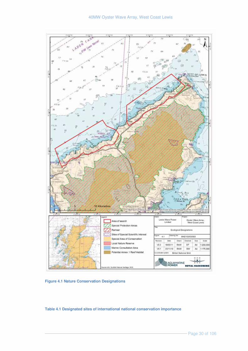
The features of interest for the key designated sites in proximity to the area of search are listed below, in Table 4.1 and shown in Figure 4.1. These will be discussed in further detail in the relevant sections of this document (i.e. Ornithology, Terrestrial and Intertidal Ecology, and Marine Ecology).
There are no designated sites within the area of search. There are however several international designations within the vicinity of the area of search, the nearest of which is the Lewis Peatlands SAC, SPA and Ramsar sites, lying approximately 500 m inland.
The nearest nationally designated site is the Loch Scarrasdale SSSI which is approximately 10 km from the area of search and is designated for its blanket bog habitat. There are no other categories of national designation such as National Nature Reserves or National Parks within the vicinity of the development site.
There are no local designations within the immediate vicinity of the development site. Loch Ròg, approximately 6 km south of the area of search, is a Marine Consultation Area (MCA) – a non-statutory designation that recognises the sites high quality and sensitive marine habitats and species.
40MW Oyster Wave Array, West Coast Lewis
Page 30 of 106
Figure 4.1 Nature Conservation Designations
Table 4.1 Designated sites of international national conservation importance
40MW Oyster Wave Array, West Coast Lewis
Page 31 of 106
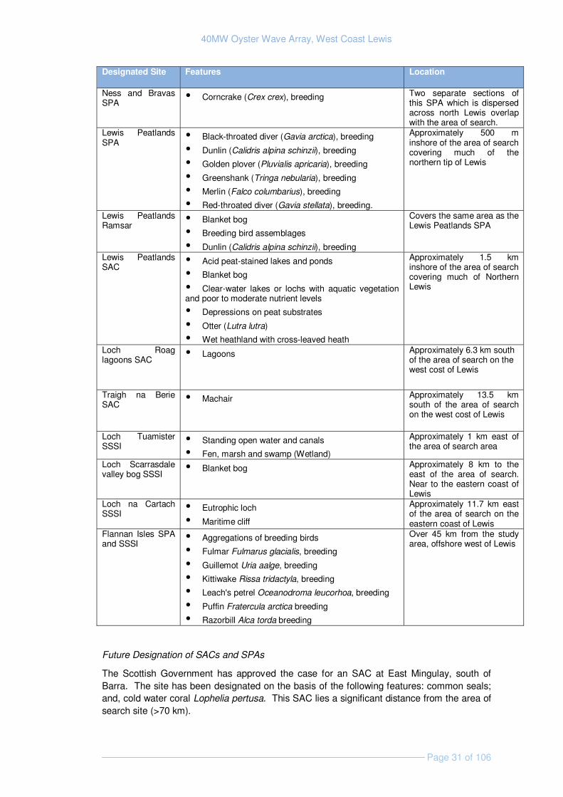
Designated Site Features Location
Ness and Bravas SPA
� Corncrake (Crex crex), breeding Two separate sections of this SPA which is dispersed across north Lewis overlap with the area of search.
Lewis Peatlands SPA
� Black-throated diver (Gavia arctica), breeding
� Dunlin (Calidris alpina schinzii), breeding
� Golden plover (Pluvialis apricaria), breeding
� Greenshank (Tringa nebularia), breeding
� Merlin (Falco columbarius), breeding
� Red-throated diver (Gavia stellata), breeding.
Approximately 500 m inshore of the area of search covering much of the northern tip of Lewis
Lewis Peatlands Ramsar
� Blanket bog
� Breeding bird assemblages
� Dunlin (Calidris alpina schinzii), breeding
Covers the same area as the Lewis Peatlands SPA
Lewis Peatlands SAC
� Acid peat-stained lakes and ponds
� Blanket bog
� Clear-water lakes or lochs with aquatic vegetation and poor to moderate nutrient levels
� Depressions on peat substrates
� Otter (Lutra lutra)
� Wet heathland with cross-leaved heath
Approximately 1.5 km inshore of the area of search covering much of Northern Lewis
Loch Roag lagoons SAC
� Lagoons Approximately 6.3 km south of the area of search on the west cost of Lewis
Traigh na Berie SAC
� Machair Approximately 13.5 km south of the area of search on the west cost of Lewis
Loch Tuamister SSSI
� Standing open water and canals
� Fen, marsh and swamp (Wetland)
Approximately 1 km east of the area of search area
Loch Scarrasdale valley bog SSSI
� Blanket bog Approximately 8 km to the east of the area of search. Near to the eastern coast of Lewis
Loch na Cartach SSSI
� Eutrophic loch
� Maritime cliff
Approximately 11.7 km east of the area of search on the eastern coast of Lewis
Flannan Isles SPA and SSSI
� Aggregations of breeding birds
� Fulmar Fulmarus glacialis, breeding
� Guillemot Uria aalge, breeding
� Kittiwake Rissa tridactyla, breeding
� Leach's petrel Oceanodroma leucorhoa, breeding
� Puffin Fratercula arctica breeding
� Razorbill Alca torda breeding
Over 45 km from the study area, offshore west of Lewis
Future Designation of SACs and SPAs
The Scottish Government has approved the case for an SAC at East Mingulay, south of Barra. The site has been designated on the basis of the following features: common seals; and, cold water coral Lophelia pertusa. This SAC lies a significant distance from the area of search site (>70 km).
40MW Oyster Wave Array, West Coast Lewis
Page 32 of 106
The designation of further marine SPAs and offshore SACs is currently being investigated by the statutory nature conservation agencies. There are no current proposals for new sites or extensions to existing sites within or adjacent to the area of search.
Seal Conservation Measures
In response to local declines in common seal numbers, the Scottish Government introduced conservation orders under the Conservation of Seals Act 1970 to provide additional protection on a precautionary basis for vulnerable local populations of common seals. The Marine (Scotland) Act 2010 has introduced provisions for existing orders to continue, and for new ones to be introduced administratively as Seal Conservation Areas.
The Special Committee on Seals (SCOS) Report 2009 noted a long term decline (35%) between 1996 and 2008 in the population of common seals in the Western Isles. The report indicated that August counts of common seals in the Outer Hebrides have declined at an average annual rate of approximately 3%. Although this rate of decline is not as severe as in some other parts of Scotland (Shetland, Orkney and the Firth of Tay), it has continued over 12 years. The highest count was in 1996 (2,820) and the latest count in 2008 (1,804).
SCOS recommended that seal conservation measures be considered for the Western Isles. This was achieved by the introduction of a Seal Conservation Area for common seals in the Western Isles under the Marine (Scotland) Act 2010 when its seal provisions were implemented on 31 January 2011. This will remain in place until such time as concerns about this local population are resolved.
4.1.2 Identification of Key Issues & Sensitivities
A series of conservation objectives have been set for the sites listed above; these are generally to maintain the abundance, extent and distribution of features. There is a potential for development to affect the integrity and conservation status of the sites listed above and their features. The potential impacts on the features of interest for designated sites are discussed in detail in the relevant sections of this document (4.3 Terrestrial and Intertidal Ecology and 4.4 Ornithology;).
4.1.3 Approach to EIA
The investigations to inform future impact assessment in relation to designated features will be detailed in the relevant sections of this scoping study. The EIA will address the potential impacts on the nature conservation interests based on a realistic worst case scenario.
The need for Appropriate Assessment (see Section 2.4.1) will be determined as part of the EIA process.
4.2 Benthic Ecology
This section primarily covers benthic ecology. Information regarding marine fish and shellfish species is discussed in Section 4.6, with intertidal ecology discussed in Section 4.3.
4.2.1 Existing Environment
Aquamarine Power research has shown that the average annual wave power indicates that the area has one of the most energetic wave environments in Europe (Section 3.1.1). Lewis
40MW Oyster Wave Array, West Coast Lewis
Page 33 of 106
also lies in the path of the Gulf Stream, which helps to keep winter sea temperatures above those on the mainland and encourages the growth of warm-water species at higher latitude than occurs on the east coast of Scotland (Barne et al., 1997). The seabed across the site is composed of exposed rock, boulders and areas of coarse sand and gravel. These conditions determine the marine ecology features at the proposed development site.
A study commissioned by Marine Scotland, in support of the Saltire prize leasing round, has indicated that much of the north west coast of Lewis may be classed as infralittoral coarse sediment (Harald et.al.,2010). A brief inspection of the video footage, also collected by Marine Scotland (which has been made available via YouTube), has revealed that the area is relatively uniform and is comprised of mainly bedrock and boulders with sand filled gullies and crevices. The faunal assemblage observed in the footage is of limited diversity typical of high energy wave environments, containing species such as: dead mans fingers (Alcyonium digitatum), sea urchins such as Echinus esculentus, sponges such as Polymastia and brittle stars such as Ophiothrix fragilis.
A more detailed seabed survey off the Butt of Lewis, just outside the area of search, suggests that where sand and gravel substrates exist in this region, they support limited biodiversity (possibly due to their mobility), with large populations of relatively few species (Gubbay, 1988). It’s expected that areas of near shore exposed bedrock and boulder within the area of search will support more diverse communities; particularly where there are areas of kelp.
A subtidal survey undertaken in support of the EIA for a wave development project in Siadar Bay, (close proximity to the area of search), stated that ”the infralittoral zone is typical of such zones on the Atlantic coast of Scotland and, as such, is unlikely to support species of conservation importance”. Although no such species were found during the Siadar survey, the horse mussel Modiolus modiolus was found forming beds at two locations within, and one location very close to, the area of search (Harrald et.al., 2010). These locations are displayed in Figure 4.1. Horse mussel beds are a UK BAP habitat and, if deemed to be of conservation importance, can be proposed for protection under the Habitats Directive within the Annex I habitat; making them of conservation importance (Tyler-Walters, 2007).
4.2.2 Identification of Key Issues & Sensitivities
The key issues associated with benthic ecology are discussed below; those anticipated to have the greatest effect and will be scoped in to the EIA are: physical disturbance, habitat alteration, habitat loss and disturbance of Modiolus beds (Table 6.1).
Physical disturbance: Construction activities will cause direct physical disturbance such as abrasion of the seabed. These impacts will be largely temporary and localised to the piles that support each Oyster device and the infrastructure that links the devices.
Habitat alteration: Areas impacted by installation activity will undergo habitat alteration during construction and again during decommissioning. The areas likely to suffer the greatest impact will be located immediately around the piles and the connecting infrastructure. During installation temporary habitat alteration may also occur in small discrete areas where the jack-up barges’ feet are placed.
Changes to wave climate may alter the nature of the subtidal environment and result in changes in species composition. The devices and infrastructure are also likely to become colonised, forming an artificial reef. Given the specialist nature of species which live in wave exposed environments, such as the North West coast of Lewis, it is expected that the species colonising the devices will be those which are already present in the area.
40MW Oyster Wave Array, West Coast Lewis
Page 34 of 106
Habitat loss: The installation of piles, and structures linking the devices, represent a direct loss of seabed habitat within the installation footprint, although this loss is ultimately reversible. The area of natural seabed lost will be very small in relation to the overall area of similar habitats likely to exist within the study area. The footprint of one device on the seabed floor is approximately 12.6 m2 and therefore a maximum of 40 devices would provide a habitat loss of 504m2. There is potential for the devices to act as artificial reef structures, and this will be further explored during EIA.
Disturbance to Modiolus beds: As Modiolus beds are protected under the UK Biodiversity Action Plan and are particularly sensitive to a number of impacts including smothering, changes in flow, Abrasion & physical disturbance, changes in water chemistry and changes in the biological communities ((Tyler-Walters, 2007). The impacts to modiolus beds are likely to be caused during construction and will depend on their proximity the any construction activities.
Suspended sediments: Disturbance of seabed sediments during construction and decommissioning activities may result in temporary and local increases in water turbidity. In such a high energy environment any alteration relative to existing conditions are likely to be negligible and therefore this will be scoped out of the EIA.
Smothering: When suspended sediments settle on to the seabed sessile organisms can be smothered, which can result in a limited supply of oxygen and food and provide difficulties with the removal of wastes. Such a smothering effect is unlikely to be significant at the proposed site, where organisms are adapted to high energy and variable conditions and where there is limited seabed sediment and therefore this will be scoped out of the EIA.
4.2.3 Approach to EIA
Lewis Wave Power is aware of the need to acquire site-specific benthic data to inform impact assessment (see table below) and will seek advice from the Marine Scotland Licensing Operations Team, Marine Scotland Science and SNH to help inform the scope of benthic data collection.
Lewis Wave Power is aware of the recent release by Institute of Ecology and Environmental Management (IEEM) of Guidelines for Ecological Impact Assessment in Britain and Ireland, Marine and Coastal. It is anticipated that impact assessment would draw upon this and other relevant guidance, as appropriate.
The table below outlines the additional data that is being / will be acquired to support the EIA.
Data Requirement Method Data Sources
Existing marine ecological data review (desk based)
Identify and collate any existing subtidal data collected from with the area of search to describe site characteristics and identify data gaps.
JNCC Coastal Directory, Siadar wave energy project ES, NBN gateway (MNCR data), MarLin website; MESH website, etc.
40MW Oyster Wave Array, West Coast Lewis
Page 35 of 106
Data Requirement Method Data Sources
Site-specific benthic survey data (field based)
Benthic survey of the site, using drop-down/towed video.
To be commissioned by Lewis Wave Power
4.3 Terrestrial and Intertidal Ecology
4.3.1 Existing Environment
Terrestrial Habitats
The north-west facing coastline within the area of search is characteristic of the wider west Lewis coastline. It is exposed and dominated by cliffs and rocky shores composed of Lewisian gneiss, with several small embayments characterised by cobbles and boulders.
A site walkover which covered part of the area of Search was conducted in October 2010. Terrestrial habitats recorded during the walk over included spray zone lichen covered rocks, maritime grassland, maritime heath, dry heath and lichen-dominated stone dykes. Areas of cliff erosion were also observed. Parts of the area of search were used for crofting and grazed common land was identified adjacent to the area of search.
Further inland, the Lewis Peatlands SAC located approximately 1.5 km at its nearest point from the area of search, is designated for peatland habitats of blanket bogs, natural drystrophic lakes and ponds, and oligotrophic to mesotrophic standing waters with vegetation of shoreweed Littorelletea uniflorae and/or of Isoëto-Nanojuncetea. Northern Atlantic wet heaths with cross leaved heather Erica tetralix, along with depressions on peat substrates of Rhynchosporion (beaked sedges) and the European otter Lutra lutra are also present as qualifying features.
Intertidal Habitats
The 35 km stretch of coast line, between Arnol and the Butt of Lewis which includes the majority of the area of search was described by Powell et. al. (1979) as a good example of fully exposed shelving rocky shore in north-west Britain.
The shores of the area of search are characterised by small regions of bedrock, rock platform, rock platform with banks of gravel, rock platform with loose boulders and small areas of sand particularly in the northern part extent of the area of search (http://www.magic.gov.uk). Limited intertidal study work has previously been completed around Siadar Bay (within the area of search) as part of an EIA for the Siadar Wave Energy Project. Fauna found during the survey included small mussels, limpets, edible periwinkle Littorina littorea, acorn barnacle Semibalanous balanoides and the beadlet anemone Actinia equina. The rocky shores to the north of Siadar Bay were found to be more exposed and subsequently support a more limited fauna and flora. No unusual or rare or protected species were found during this survey.
Protected Species
A number of UK BAP species have to date been identified within the general area including a number of flowering plants (the curved sedge Carex maritima, the Scottish scurvy grass Cochlearia officinalis subsp. scotica, the frog orchid Coeloglossum viride, the Eyebrights
40MW Oyster Wave Array, West Coast Lewis
Page 36 of 106
Euphrasia campbelliae and Euphrasia marshallii and the field gentian Gentianella campestris), the conifer Juniperus communis the butterfly Coenonympha tullia, the bees species Bombus (Subterraneobombus) distinguendus and Bombus (Thoracombus) muscorum, the moths Blepharita adusta, and Hepialus humuli and the otter Lutra lutra. (National Biodiversity Network [NBN] Gateway).
The UK BAP priority species Fucus distichus has not been recorded in the vicinity of the area of search (NBN Gateway). However this species, which is found along highly exposed coastlines, is recorded elsewhere along the western coast of South Lewis (White 2007) and has potential to be present within the area of search.
The European otter Lutra lutra is a semi-aquatic mammal, which is common around the freshwater and coastal areas of Scotland. UK Populations are internationally important, especially since their widespread decline across much of their western European range (JNCC, 2004). Populations in coastal areas utilise shallow, inshore marine areas for feeding and require fresh water for bathing and terrestrial areas for resting and breeding holts (JNCC, 2004). Where otters live in coastal areas (particularly in Scotland) they tend to have a largely diurnal habit, live in group territories, and have home ranges below 5 km (Kruuk, 1996).
All otters within Scottish waters are protected by the following national and international obligations:
� Council Directive 92/43/EC on the Conservation of Natural Habitats and of Wild Fauna and Flora, Annex II and Annex IV (the 'Habitats Directive'). Annex II and IV of the EC Habitats Directive 92/43;
� Appendix II of the Bern Convention;
� The Wild Mammals Protection Bill, 1996;
� Wildlife and Countryside Act, 1981; and
� The otter is a UK Red Data Book species.
The Western Isles provide an important stronghold for otters in the British Isles (Barne et al., 1997), and the otter is a qualifying feature of the nearby Lewis Peatland SAC.
A walkover survey in October 2010 identified fresh otter spraint under the pedestrian bridge over Abhainn Bhuirgh (NB 408,572). Otter records are also presented on the NBN gateway website (submitted by the Mammal records from Britain from the Atlas of Mammals (1993) and the Scotland Otter Survey Database). It is therefore likely that otters are present in the wider area of search.
Around 6% of the world's remaining functional population of freshwater pearl mussel Margaritifera margaritifera is found in Lewis and Harris, and NBN gateway also records the presence of eel Anguilla Anguilla, Atlantic salmon Salmo salar and brown trout Salmo tuttra in the region. There is potential for numerous rivers within the area of search, including Abhainn Bhuirgh, Abhainn Dhail and Abhainn Shaidar to provide habitat for these species within the vicinity of the proposed development.
Red deer Cervus elephas and mountain hare Lepus timidus are also recorded on the Western Isles (NBN Gateway) for north west Lewis.
40MW Oyster Wave Array, West Coast Lewis
Page 37 of 106
Local Biodiversity Action Plan
The Western Isles Local Biodiversity Action Plan has prepared plans for several habitats and species, none of which are likely to be affected by the proposed development due to the geographical location. The Western Isles Species Priority List identifies several priority animals and plants which may be encountered along the north-west Lewis coastline, including otter, Scottish scurvy grass and several eyebright species.
4.3.2 Identification of Key Issues & Sensitivities
The exact potential risks associated with the terrestrial and intertidal habitats and species will be dependant on the location of the onshore infrastructure, and this will be further informed by ecological surveys, along with engineering considerations. Of the key issues discussed below; those anticipated to have the greatest effect are: loss of habitat and species, and disturbance of otters (Table 6.1). All potential risks outlined below will be considered further during EIA.
Habitat and Species loss: Permanent physical loss of terrestrial habitats and species in the footprint of any coastal-based supporting infrastructure such as the shed that will house the generators and any directional drilling activity may occur during construction and installation. Onshore infrastructure is currently estimated to require an area approximately 4,000m2. Access tracks may be required to enable access to the onshore infrastructure and may cause habitat fragmentation.
Terrestrial disturbance: Temporary disturbance of terrestrial habitats and species in the footprint of any access routes, lay-down areas and construction compounds may occur during construction, installation, and decommissioning activities. There may be noise and light disturbance during construction, operation and maintenance and decommissioning activities.
Intertidal disturbance: Temporary disturbance of intertidal habitats and species in the footprint of any access routes, lay-down areas and construction compounds may occur during construction and installation. Directional drilling would take place back from the shore to connect the marine devices to the existing grid system and cables will need to be laid down straight back from the site of drilling activity. The devices themselves will be transported to the development site by sea, and so limited direct impacts to the intertidal region are anticipated.
Change to marine processes: Operation of the Oyster devices may cause changes in marine processes such as altering wave and current regimes in the local area. This may in turn affect the nature of intertidal habitats. An alteration in the pattern of infralittoral zonation or a shift in communities or species present may occur if the marine processes are modified, with a potential loss of species adapted to extremely exposed environments.
Disturbance of otters: Otter disturbance in the vicinity of any access routes, lay-down areas and construction compounds may occur during construction, operation and decommissioning of the land based infrastructure.
Although otters will swim around the coastline it is less likely they will travel out to the depths where the devices will be located. Otters show a strong preference for multiple short dives in shallow waters of 0-3 m of depth, with evidence suggesting deep dives are less successful for catching prey (Nolet et al., 1993). There is potential for otter to be disturbed by construction noise during directional drilling and construction of buildings, with potential for
40MW Oyster Wave Array, West Coast Lewis
Page 38 of 106
noise disturbance during operation of the onshore components. Artificial lighting may also have an impact on otters in the area.
Pollution: leaks or spills from vehicle, vessel or infrastructure may occur during construction, operation, maintenance and decommissioning of the proposed scheme causing negative effects to terrestrial and/or intertidal species.
4.3.3 Approach to EIA
As part of a baseline assessment developers are likely to need to undertake an Extended Phase I Habitat Survey of the terrestrial area which may be affected by the development. This survey presents a standardised system for classifying and mapping wildlife habitats in all parts of the UK and the extent of the “study area” for this survey will determined by the eventual footprint of the development. On completion of the survey a map can be produced to show areas of recognised habitats such as blanket bog, water, shingle, marsh from which the percentage of each habitat type can be calculated. Target notes, taken during the survey, can be used to identify points where evidence of species of interest (such as breeding birds, and otters) is found.
Based on the results of the Phase I habitat survey and potential presence of protected habitats and species there may be a requirement to undertake more detailed surveys to establish the distribution and use of the area by such species. These additional surveys may include National Vegetation Classification (NVC) surveys and specialist surveys for otter, badger or water vole.
Impact assessment will be determined through reference to ecological guidance including IEEM (2006; 2010) and SNH (2009). The table below outlines the additional data that is being / will be acquired to support the EIA.
Data Requirement Method Data Sources
Collation of Existing marine ecological data (desk based)
Collation and review of any previous records or data relating to the presence of protected habitats and species
Highland Council Local Biodiversity Action Plan; National Biodiversity Network; Scottish Wildlife Trust; SNH; JNCC Coastal Directory, Siadar wave energy project ES, NBN gateway (MNCR data), MarLin website; MESH website, etc.
Identification of principal communities and habitats across site of terrestrial onshore works (field study) to inform location of onshore works
For method see Phase 1 Habitat Survey Handbook, Joint Nature Conservation Committee (2007) and IEEM 2011. Survey findings used to identify the requirement for any further detailed surveys.
JNCC SNH Commissioned survey
Identification of principal communities and habitats across site of intertidal onshore works (field study)
For method see Marine Monitoring Handbook, Davies et al., (2001). Survey findings used to identify the requirement for any further detailed surveys. Permanent relocatable vertical shore transect(s) will be surveyed on the shore to provide a monitorable baseline for future assessment
JNCC SNH Commissioned survey
Presence, distribution and abundance of otters within the area of seach (desk based and field study) to inform location of onshore works and mitigation
Collate information on the presence, location and abundance of otter holts within study area. Undertake a visual inspection of the intertidal area in proximity to the cable landfall and substation.
SNH - Scotland wide otters surveys (1977-79; 1984-85 and 1991-94). JNCC website FRS Commissioned survey Consultation - SNH
40MW Oyster Wave Array, West Coast Lewis
Page 39 of 106
Data Requirement Method Data Sources
Look for the presence of holts or spraints. If otter shelters are located within 30m or breeding area within 200m of potential development, a European Protected Species licence will be applied for from the Scottish Executive. Pre construction surveys and mitigation measures will be informed through consultation with SNH.
Presence, distribution and abundance of protected species and terrestrial invasive species (field study)
Walkover survey findings used to identify the requirement for any further detailed surveys.
JNCC SNH Commissioned survey
Potential Appropriate Assessment for otters (desk study)
The decision for if this is required would be made by SNH
SNH
4.4 Ornithology
4.4.1 Existing Environment
Early consultation with SNH and the RSPB has highlighted a presence of breeding Arctic terns and red throated divers in the area although it has not been confirmed it is expected that these species may feed in shallow bays within the area of search. Fulmars, shags and black guillemot are also known to breed on the nearby coast. Over wintering birds may include occasional great northern divers, and red-throated divers and terns are known to feed in shallow bays in the south of the proposed footprint (pers comm. SNH) but this stretch of coast hosts relatively few divers in general. A small flock (ca. 50) of eider have wintered off Borve (within the southern part of the area of search) in recent years. Migratory birds regularly include Manx and sooty shearwater, often in large numbers. Deeper water species such as great shearwater have been recorded on an almost annual basis at Labost which is located within the southern part of the area of search.
The NBN gateway which displays data using 10 grid squares shows several UK BAP bird species which have been recorded within squares that that overlap with the area of search these include: corn crake Crex crex, reed bunting Emberiza schoeniclus, Eurasian curlew Numenius arguata, common cuckoo Cuculus canorus, house sparrow Passer domesticus, Arctic skua Stercorarius parasiticus, Eurasian tree sparrow Passer montanus, black-throated diver Gavia arctica and northern lapwing Vanellius vanellus. (NBN Gateway).
Designated Sites
The Lewis Peatlands SPA is located approximately 500 m inshore of the area of search at its closest point (Figure 4.1) and is designated for breeding birds including black-throated diver, dunlin, golden plover, greenshank, merlin and red throated diver.
The Lewis Peatlands Ramsar is located approximately 500 m inshore of the area of search at the closest point and is designated for breeding bird assemblages and breeding dunlin Calidris alpina schinzii.
The Ness and Bravas SPA is separated into various different sites at different geographical locations across north Lewis, two such sites are within the area of search (Figure 4.1 and Table 4.1). This site is designated for breeding corncrake.

40MW Oyster Wave Array, West Coast Lewis
Page 40 of 106
The Flannan Isles SPA and SSSI are located west of Lewis, over 45 km from the area of search, and incorporate a group of seven rocky islands and outlying skerries. The SPA boundary extends 2 km into the sea. The islands provide a strategically placed nesting locality for seabirds, which feed in the waters off the Western Isles. The sites support aggregations of breeding fulmar Fulmarus glacialis, guillemot Uria aalge, kittiwake Rissa tridactyla, leach's petrel Oceanodroma leucorhoa, puffin Fratercula arctica and razorbill Alca torda.
Seabird Nesting Counts 2000
The Seabird 2000 dataset is owned by the JNCC and contains data from a full census of all of the breeding seabirds in Britain and Ireland. The data were gathered between the years 1999 and 2003 from both coastal and inland colonies. The seabird nesting counts within the area of search are displayed in Table 4.2 (source: http://www.magic.gov.uk) starting with the northern most data points and working south.
Table 4.2 Seabird Nesting Counts within the area of search source: www.magic.gov.uk
Site Species Nesting count Aird Dell Arctic Tern Sterna paradisaea 10 Loch Dibadale Common Gull Larus canus 18 Loch Drollavat Common Gull 3 Loch Bacavat Common Gull 5 Barvas Common Gull 2
Arctic Tern 129 Geodha Chaol to Geodha Ruadh Black Guillemot - Cepphus grille 92 Arnol Common Gull 11 Bragar
Common Gull 3 Arctic Tern 2
Sgeir Mhic Shaoir
Northern Fulmar - Fulmarus glacialis 12 Herring Gull - Larus argentatus 4
Aird Mhor Bragair
Northern Fulmar 29 European Shag - Phalacrocorax aristotelis
10
Herring Gull 4 Great Black-backed Gull - Larus marinus
1
North Shawbost Northern Fulmar 23 Garson Point Northern Fulmar 4 Druim Na Muilne Northern Fulmar 13 Creagan Thormaid Northern Fulmar 526
European Shag 5 Aird Dalbeg Northern Fulmar 299
European Shag 11 Cnoc Beag Geodha Na Muic
Northern Fulmar 161 European Shag 15 Herring Gull 1
Breeding Birds
A survey of the breeding birds of the shore area of Siadar and Baile an Trusieil was carried out as part of the environmental impact assessment for the Siader Wave Energy Project in 2007. Results are summarised in Table 4.3, which is an extract from the technical survey report. None of the breeding bird populations found on the site represents more than 0.1 percent of the UK breeding population. The calling male corncrake near the site represents 0.2 percent of the UK population (based on the 1998 estimate in Baker et. al., 2006) .
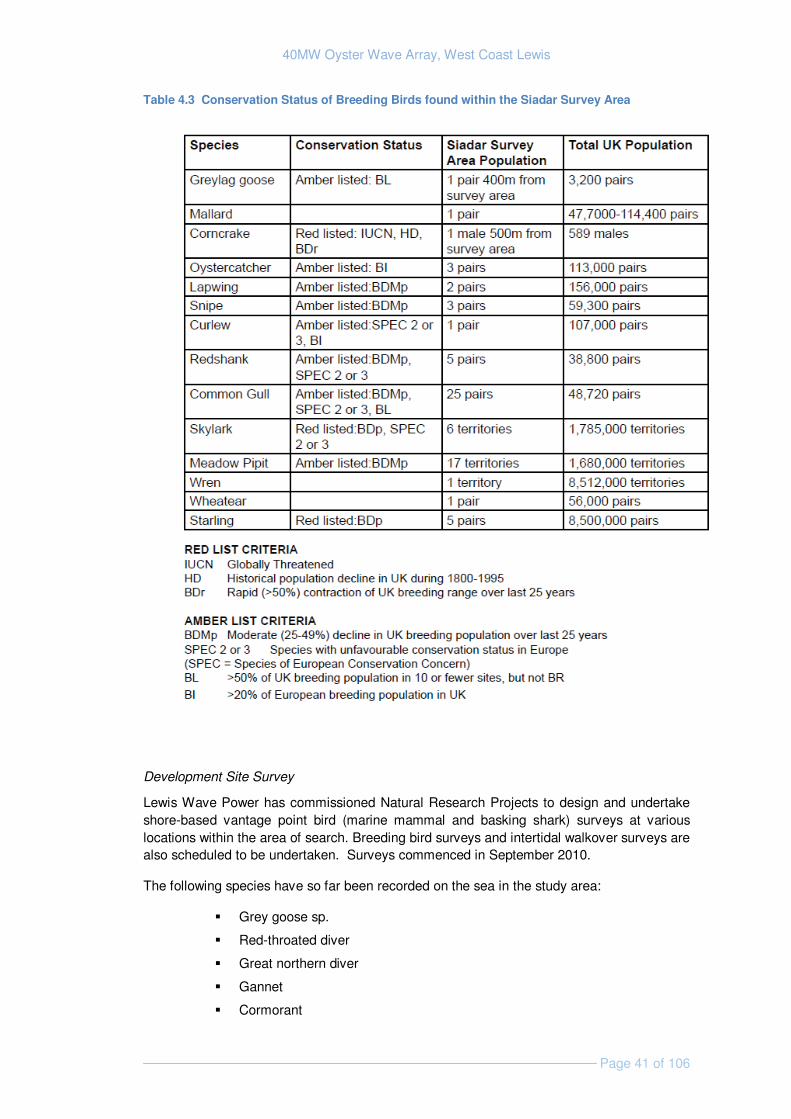
40MW Oyster Wave Array, West Coast Lewis
Page 41 of 106
Table 4.3 Conservation Status of Breeding Birds found within the Siadar Survey Area
Development Site Survey
Lewis Wave Power has commissioned Natural Research Projects to design and undertake shore-based vantage point bird (marine mammal and basking shark) surveys at various locations within the area of search. Breeding bird surveys and intertidal walkover surveys are also scheduled to be undertaken. Surveys commenced in September 2010.
The following species have so far been recorded on the sea in the study area:
� Grey goose sp.
� Red-throated diver
� Great northern diver
� Gannet
� Cormorant
40MW Oyster Wave Array, West Coast Lewis
Page 42 of 106
� Shag
� Great skua
� Common gull
� Herring gull
� Great black-backed gull
� Kittiwake
� Guillemot
� Black guillemot
4.4.2 Identification of Key Issues & Sensitivities
A range of birds could potentially be affected by the development and the species presented in Table 4.2 and 4.3 may be present to some extent including seabirds which feed and roost in offshore areas, such as divers, grebes, gannets, shearwaters, petrels, seaducks, auks, gulls and terns. A wider range of species may move through the site, either locally on a daily basis or during national or international migration. Such species include the seabirds listed above, as well as other wildfowl, waders and migrant songbirds. The potential presence of species of high conservation interest such as corncrake must be considered carefully.
The key ornithological effects are discussed below; all of which will be considered further within the EIA (see Table 6.1).
Disturbance or displacement due to human activity and noise: The presence of increased human activity and specific construction, operation, maintenance and decommissioning impacts, including increase of vessel traffic in the area, construction noise and vibration will have the potential to disturb and displace birds from an area of use (for breeding, feeding, resting, passage, etc).
Collision of diving birds with the device: Due to the slow moving nature of the Oyster flaps it is deemed unlikely that a diving bird would collide with the device and Aquamarine Power has no experience of this occurring at their EMEC demonstration site.
Loss of potential foraging habitat and food sources: Noise associated with the installation, for example vessel traffic, is unlikely to cause significant displacement of prey fish species around the array site. There is potential that the array, once installed may cause an aggregation of fish species and therefore have a beneficial impact on birds however the effect of this is impossible to predict.
The footprint of the devices and onshore infrastructure would ‘remove’ a small percentage of the available habitat and cause disturbance within a limited area for a relatively short defined period. The development is not predicted to interact with any important feeding areas for birds such as shallow bays and therefore the impact is expected to be minimal.
4.4.3 Approach to EIA
Based on information currently available to inform the assessment of marine renewables energy developments on marine birds, the likelihood of occurrence and the consequence of impacts are difficult to determine. Impacts are location and technology-specific and therefore Lewis Wave Power’s EIA will be largely informed by survey data and the findings of impact assessments undertaken in relation to their other Scottish Oyster sites / development locations.
40MW Oyster Wave Array, West Coast Lewis
Page 43 of 106
The table below outlines the additional data that is being / will be acquired to support the EIA.
Data Requirement Method Data Sources
Existing data review (desk based)
Desk-based assessment to consider likely species present, nesting locations, breeding season timings, potential feeding areas, flyways or migratory routes, moulting areas, areas used for maintenance activities (e.g. loafing, washing).
JNCC data, Marine Renewables SEA, SNH, Wetland Bird Survey (WeBS).
Determine the existence of birds (feeding, roosting, etc) in proximity to the proposed site. (desk based and field based)
Shore based vantage point surveys.
Lewis Wave Power has commissioned Natural Research Projects.
Use of area by resident bird populations (desk based and field based)
Shore based vantage point surveys.
Lewis Wave Power has commissioned Natural Research Projects.
Use of area by migratory species on passage (desk based and field based)
Shore based vantage point surveys.
Lewis Wave Power has commissioned Natural Research Projects.
4.5 Marine Mammals
4.5.1 Existing Environment
To inform EIA, Lewis Wave Power has commissioned Natural Research Projects to undertake shore-based vantage point surveys at various locations within the area of search for marine mammals (as well as basking sharks and birds). The survey protocol may be subject to some small changes and is currently being finalised and agreed with SNH and other key stakeholders.
Based on 48 hours of observation in September/October 2010, the following species have been sighted:
� Common dolphin Delphinus delphis;
� Harbour porpoise Phocoena phocoena;
� Minke whale Balaenoptera acutorostrata;
� Risso’s dolphin Grampus griseus (possible); and
� Grey seal Halichoerus grypus.
Cetaceans
All marine mammals are protected species to varying degrees and there are a number of legislative requirements that must be met by developers. Grey and harbour (common) seals (Phoco vitulina), bottlenose dolphins (Tursiops truncates) and harbour porpoise are protected under European legislation and are listed under Annex II of European Habitats Directive. All species of porpoises, dolphins and whales (cetaceans) are listed on Appendix II of the Bern Convention and on Appendix IV of the EC Habitats Directive as species of European Community Interest in need of strict protection. All small cetaceans are covered
40MW Oyster Wave Array, West Coast Lewis
Page 44 of 106
by the terms of the international agreement ASCOBANS (Agreement on Conservation of Small Cetaceans of the Baltic and North Seas). Under the Habitat Regulations 1994 (as amended) it is an offence deliberately or recklessly, to disturb, kill, capture, or injure any cetacean and damage or destroy a breeding or resting area.
Other species that may be encountered in the waters around Lewis include (Reid et. al., 2003):
� Northern right whale Eubalaena glacialis;
� Minke whale Balaenoptera acutorostrata;
� Atlantic white-sided dolphin Lagenorhynchus acutus;
� White-beaked dolphin Lagenorhynchus albirostris;
� Humpbacked whale Megaptera noveangliae;
� Killer whale Orcinus orca; and
� Bottlenose dolphin.
The Marine Renewables SEA (Scottish Executive, 2007) review concurs with this list, although humpback whale and northern right whale are not mentioned. This report also suggests long finned pilot whale (Globicephala melas) may use waters off the North West coast of Scotland.
While several studies have shown west Scotland, and especially the Hebrides, to be of particular importance to cetacean and especially harbour porpoises, interest is focused on waters to the east of Lewis (Clark et. al., 2010). Cetacean abundance appears to be relatively low across much of the site (0.07 /hr/km 2) with the exception of around the Butt of Lewis (3.25 hr/km2) (Harrad et. al., 2010).
Pinnipeds
2006 seal count data gathered by SMRU and presented in the Marine Renewables SEA (Scottish Executive, 2007) shows that common seals tend to be primarily distributed to the south of Lewis and around Loch Ròg, with no recordings close to the area of search. Grey seals were recorded around the northern tip of Lewis and around Loch Ròg. Small numbers (1-5) were recorded close to the area of search (Scottish Executive, 2007). There are no known haul out or breeding sites in close proximity to the site (Scottish Government, 2011).
During 2003-2008 the total grey seal pup production for all annually monitored colonies in the Outer Hebrides has not changed with a 2008 production of 12,712 grey seal pups; 30% of the total in Scotland (SCOS, 2009).
Counts of harbour seals in the Outer Hebrides in 2008 were 35% lower than the peak count in 1996. Regular surveys over the intervening period suggest that there has been a sustained but gradual decline of around 3% pa since 1996 (SCOS, 2009). Minimum estimates of harbour seal populations in 2008 showed 1,815 in the Outer Hebrides, 9.2% of the Scottish population. This population is believed to be in slow decline (SCOS, 2009).
The case for a new seal conservation area has been approved by the Scottish Government to protect seals in light of the ongoing decline around the Western Isles. The exact status and boundary of this conservation area is not yet known (Scottish Government, 2011).
40MW Oyster Wave Array, West Coast Lewis
Page 45 of 106
4.5.2 Identification of Key Issues & Sensitivities
The key issues associated with marine mammals are discussed below; those anticipated to cause a significant effect are: noise, disturbance and barrier effects (Table 6.1), all of which will be considered further within the EIA
Disturbance: from increased human activity could displace seals from any haul out, breeding or moulting sites. The Outer Hebrides are important for breeding seals but the area of search is not predicted to be an important haul out, breeding or moulting area. The onshore location of all electro-mechanical power generation equipment minimises the potential disturbance to marine mammals of maintenance activities.
Noise: The noise levels associated with installation, operation, maintenance and decommissioning of the wave array could influence the normal activities of marine mammals. Marine mammals have acute hearing and may be prone to underwater noise disturbance. Noise is important for sea mammals for the purposes of navigation, communication and finding food. An increase in noise levels can mask biological acoustic cues used for these activities.
During the operational phase of the array, noise and vibrations may result from the movement of the flaps and a periodic increase in vessel activity during maintenance. The impact of noise from the project on marine mammals around Lewis will depend on the levels of this noise and existing ambient noise in the study area.
Initial noise monitoring data have been collected for Oyster 1 at Billia Croo, Orkney (Aquamarine Power Ltd, 2010). This data indicates that cetaceans sensitive to low frequency noise may avoid an area up to 740 m from piling activity; harbour porpoise, dolphin species and killer whale may avoid an area out to 30 m, and seals to 140 m, whilst fish sensitive to underwater noise such as herring or sprat may avoid an area out to approximately 5 metres. The report concluded vessel noise may have an impact up to 200 m from the vessel.
Collision: Vessels associated with installation and maintenance of the array could cause physical harm and possible fatality to marine mammals if collisions were to occur. Collision with devices is unlikely due to the slow speed of the moving flaps. Interaction of marine mammals with the devices is hard to predict, with the possibility that mammals may be attracted to the array through curiosity or aggregation of prey species, as well as the possibility that they may be disturbed by the devices.
Barrier effects: Although the development is in a site with an open nature, Marine mammals, especially those that traverse the coastal waters of Lewis, may potentially alter their course to avoid the array when it is operational. This may have implications for cetaceans foraging patterns and may lead to an increase in energy expenditure.
Species that tend to travel close to the shore such as the harbour porpoise are considered to be most affected by this issue. This species is also relatively small and will therefore be most sensitive to increases in energy expenditure.
Accidental release of contaminants: such as fuel, from vessels associated with the construction, maintenance and decommissioning would have the potential to cause harm to marine mammals, particularly through accumulation in their prey species. The Oyster device uses fresh water as hydraulic fluid with no toxic substances or oil hydraulics and the potential for release from vessels and shore facilities is limited, with any potential carefully managed to reduce risks. Therefore the potential for this impact to occur is extremely low and will be scoped out of the EIA (Table 6.1).
40MW Oyster Wave Array, West Coast Lewis
Page 46 of 106
4.5.3 Approach to EIA
It is intended that desk-based assessment and survey outputs will be used to characterise the development site in terms of:
� Species in the area;
� Number, distribution and location of sightings;
� Known routes and movements in and around development site;
� Importance of the site to each species identified, i.e., key breeding or feeding ground;
� Specific use of the site and the temporal and spatial use, for example, known seal haul out sites, known feeding or breeding grounds and the extent of these, migration routes and what times of the year, etc; and
� Group makeup – are there young present?
The table below outlines the additional data that is being / will be acquired to support the EIA.
Data Requirement Method Data Sources
Identification of marine mammal species and abundance/distribution data for Lewis and the surrounding area
Shore based vantage point surveys.
Lewis Wave Power has commissioned Natural Research Projects.
Baseline underwater noise characteristics / noise modelling
Methodology currently being developed.
To be confirmed.
4.6 Fish and Shellfish Resources
4.6.1 Existing Environment
The area of search is predominantly within the wider area of ICES rectangle2 45E3. All species of which more than one tonne was landed from this rectangle between 2005 and 2009 are shown in Table 4.4.
2 The International Council for the Exploration of the Sea (ICES) has developed a grid system derived from degrees latitude and longitude that divides the seas into rectangles.
40MW Oyster Wave Array, West Coast Lewis
Page 47 of 106
Table 4.4 Fish and shellfish species caught within ICES rectangle 45E3 between 2004 and 2009. Source: Marine Scotland Science.
Demersal / Pelagic (live weight, tonnes) Shellfish (live weight, tonnes)
Mackerel Scomber scombrus (5734.7)
Pollack Pollachius polachius (3.22)
Nephrops (3730.6)
Herring-Clupea harengus (154.43) Sprats Sprattus sprattus (2.75)
Edible crabs- Cancer pagurus (2993.1)
Spurdog- Squalus acanthias (55.98)
Plaice Pleuronectes platessa (2.28)
Scallops Pecten Maximus (374.38)
Haddock Melanogrammus aeglefinus (32.61) Ling Molva molva (2)
Velvet Swimming crab- Necora puber (304.33)
Megrim Lepidorhombus whiffiagonis (27.98)
Blue Whiting Micromesistius poutassou (1.63)
Lobster (104.7)
Monks or Anglers Lophius sp. Squatina. Sp. (22.62)
A number of Skate and Ray species (19.3): Likely to include the thornback ray Raja clavata and the cuckoo ray Raja naevus.
Green Crab- Carcinus maenas (19.67)
Witch (10.1) Razor Clam (16.27)
Cod- Gadus morhua (5.75) Squid (3.95)
Hake Merluccius merluccius (5.67)
Crawfish (2.49)
Whiting Merlangius merlangus (5.4)
Unidentified Dogfish (4.54)
Important fish species
Important species are identified as those that are: clearly abundant within the ICES rectangle, are identified as UK BAP species, or have spawning or nursery grounds within the vicinity of the area of search. All important species will be considered in the EIA and will include, but are not limited, to the following:
Mackerel represents the greatest live weight landed from ICES rectangle 45E3 of any species (Table 4.4). They are present in the seas around Lewis and use an area for low spawning intensity that overlaps with the area of search at its northern extent (Figure 4.2) These Mackerel are part of the “Western stock” which spawn between March and July (Scottish Government, 2010a). The entire area of search is potentially used by mackerel as a nursery ground the majority of which is low intensity but the northern most section falls within the boundary of a high intensity (Figure 4.4b). Mackerel are a UK BAP species and have been identified as a species of conservation importance.
Herring, although not likely to be targeted within the area of search, is caught in large numbers within the ICES rectangle 45E3 (Table 4.4) and is abundant in the summer and autumn, using the area of search and wider region for high intensity spawning (Figure 4.2) and high intensity nursery grounds (Figure 4.4a). Herring is a UK BAP species that are known to feed within the region and are thought to be very sensitive to noise disturbance.
Cod, although unlikely to be targeted in the development site, is caught in ICES rectangle 45E3 and is an important exploited fish species in the North Atlantic particularly during summer. Cod are not thought to use the area of search for spawning but do use the area for

40MW Oyster Wave Array, West Coast Lewis
Page 48 of 106
low intensity nursery grounds and are a UK BAP species included in the OSPAR list of threatened and/or declining species or habitats (OSPAR, 2008).
Haddock is widely distributed in the western isles region and are present within ICES rectangle 45E3 (as shown in Table 4.4). Spawning takes place between February and May, with a peak in March and April; the main spawning areas are outside the area of search (Figure 4.3), but the area of search is within haddock nursery grounds of an undetermined intensity (Figure 4.5a).
Sprat, caught in relatively small numbers in ICES rectangle 45E3, is periodically abundant within the Western Isles region. The area of search is within a sprat spawning ground (Figure 4.3) and nursery grounds occur to the south (Figure 4.5a). Neither sprat nor haddock are listed as UK BAP species.
Blue Whiting are caught in low numbers within ICES rectangle 45E3 and are therefore not likely to be targeted within the area of search, however this species is important as it is a UK BAP species which also has high intensity nursery grounds that encompass the area of search (Figure 4.4a).
A number of other species will also be considered as important as they are either UK BAP species that are known to use the region, are caught in significant quantities within the region or have spawning and/or nursery grounds that overlap with the area of search, these include: Spurdog (Table 4.4 and Figure 4.5b), sandeel (Figures 4.3 and 4.5a), Norway pout (Figures 4.3 and 4.5a), lemon Sole (Figure 4.3 and 4.5a) whiting (Table 4.4 and Figure 4.4b) common skate, European hake, ling (Figure 4.4a), Thornback Ray, spotted ray and Anglerfish (Figure 4.5b).
Elasmobranchs
The elasmobranch family is made up of sharks, skates and rays (some of which are mentioned above) and is characterised by a cartilaginous skeleton. This family is known to generally have a low resilience to exploitation and population decline as low numbers of eggs are laid compared to broadcast spawners. There is also greater potential for them to be affected by changes to the sedimentary environment as feeding and egg-laying are associated with the benthos.
The most abundant ray species in the area is likely to be the thornback ray, which has a mating and spawning period throughout summer In addition, the spurdog, also known as the spiny dogfish, is found throughout the area and is the most frequently caught elasmobranch species in ICES rectangle 45E3 (Table 4.4). Many elasmobranchs are listed on the UK BAP species list or on the OSPAR list of threatened and/or declining species.
The basking shark Cetorhinus maximus is known to inhabit the waters around Lewis (NBN Gateway, 2010). This species is listed as a UKBAP and OSPAR species and is protected under the Wildlife and Countryside Act 1981 (as amended in 1985) and CITES3 .
3 CITES (the Convention on International Trade in Endangered Species of Wild Fauna and Flora) is an international agreement between governments. Its aim is to ensure that international trade in specimens of wild animals and plants does not threaten their survival.

40MW Oyster Wave Array, West Coast Lewis
Page 49 of 106
Diadromous species
Rivers and coastal seas of Britain are known to support a number of diadromous (migratory between fresh and salt waters) species, specifically sea trout Salmo trutta, Atlantic salmon Salmo salar, eels Anguilla anguilla and the lamprey species Petromyzon marinus and Lampetra fluviatilis. Atlantic salmon and lamprey are Annex II species under the European Habitats Directive.
Many rivers on the West coast of Lewis support salmon populations (Gardiner & Egglishaw, 1986). Salmon and brown trout are known to use Siadair Bay and the Abhainn Shiadair which are within the development site boundaries (RWE group and NPower renewables, 2007). Eels are also known to utilise the Abhainn Shiadair..
Shellfish and crustaceans
Nephrops is targeted within the region and makes up the largest portion of landings of any species from ICES rectangle 45E3 (Table 4.4). The majority of the nephrops landed from this rectangle is from fishing grounds that are located to the east of Lewis in an area known as the minch.
Shellfish resource exploitation within area of search is likely to be restricted to fisheries for lobster and crab due to the shallow water and large wave conditions that usually exist along the North West coast of Lewis.
Species of crab and lobster make up considerable portions of the landings from ICES rectangle 45E3 (Table 4.4) the targeted species are usually found on bedrock including under boulders, mixed coarse grounds, and offshore in muddy sand. Preliminary consultation indicates that lobster and crab are the main target species for the coastal potting fleet in north western Lewis
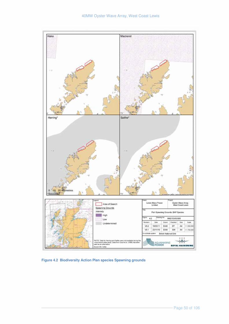
40MW Oyster Wave Array, West Coast Lewis
Page 50 of 106
Figure 4.2 Biodiversity Action Plan species Spawning grounds
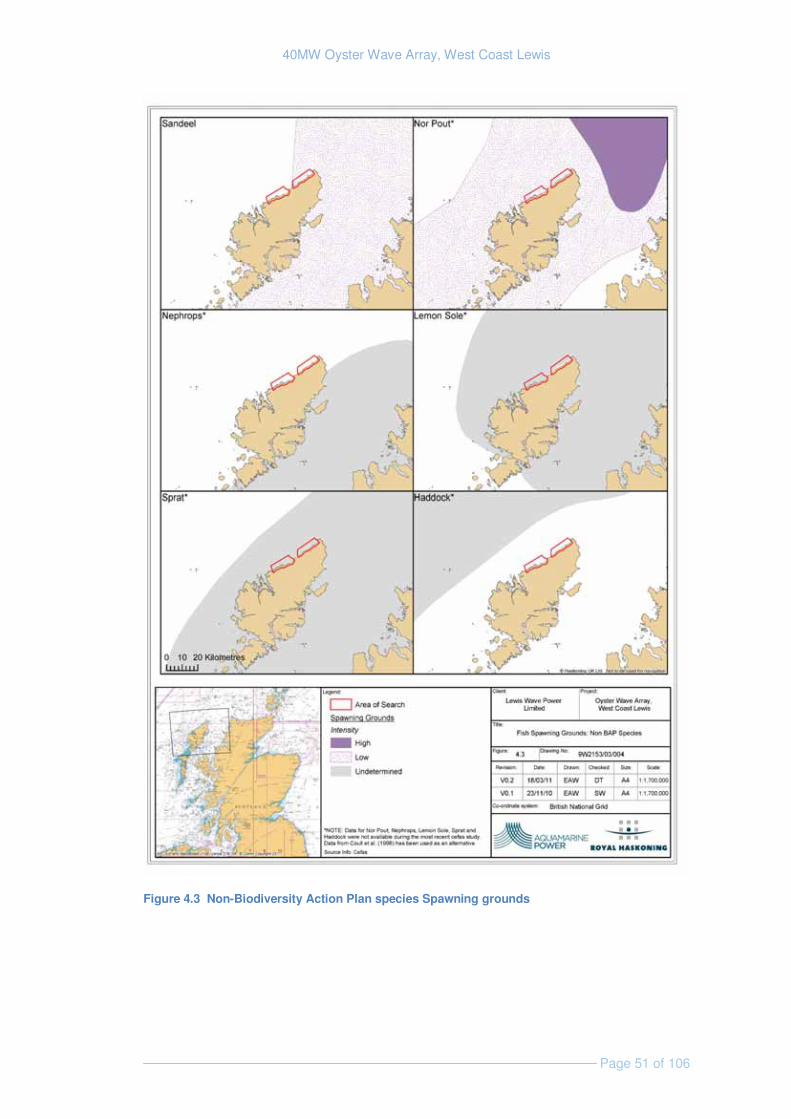
40MW Oyster Wave Array, West Coast Lewis
Page 51 of 106
Figure 4.3 Non-Biodiversity Action Plan species Spawning grounds
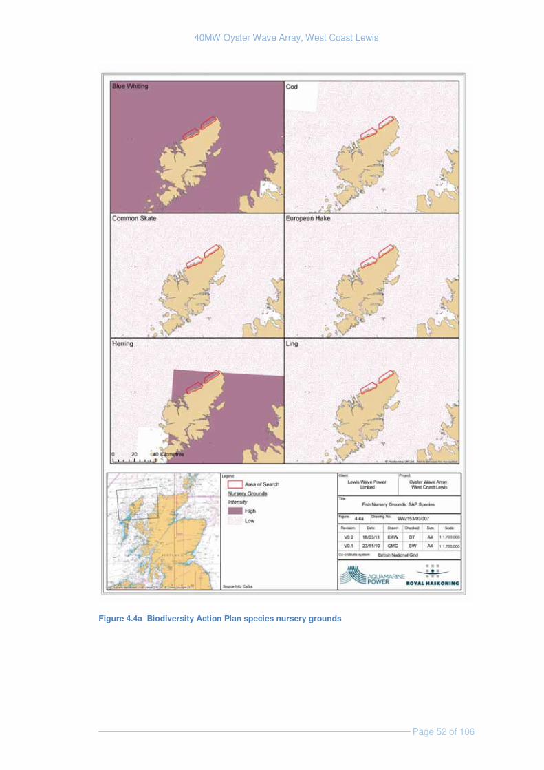
40MW Oyster Wave Array, West Coast Lewis
Page 52 of 106
Figure 4.4a Biodiversity Action Plan species nursery grounds
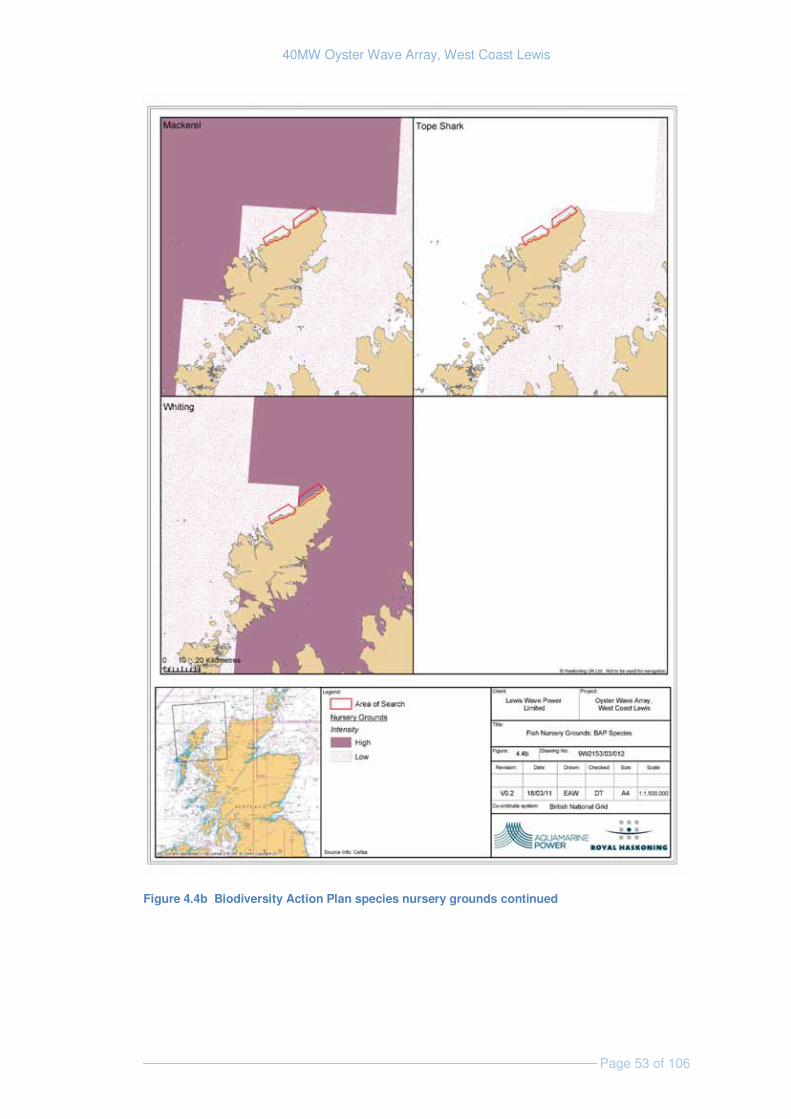
40MW Oyster Wave Array, West Coast Lewis
Page 53 of 106
Figure 4.4b Biodiversity Action Plan species nursery grounds continued
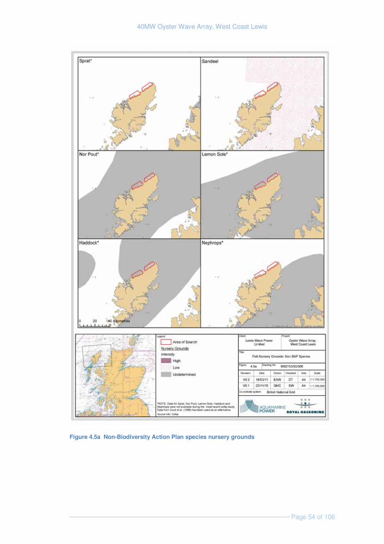
40MW Oyster Wave Array, West Coast Lewis
Page 54 of 106
Figure 4.5a Non-Biodiversity Action Plan species nursery grounds
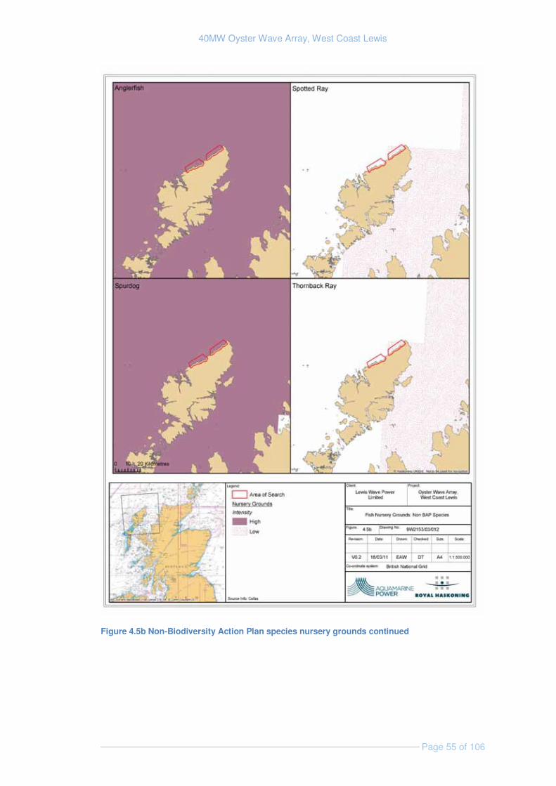
40MW Oyster Wave Array, West Coast Lewis
Page 55 of 106
Figure 4.5b Non-Biodiversity Action Plan species nursery grounds continued
40MW Oyster Wave Array, West Coast Lewis
Page 56 of 106
4.6.2 Identification of Key Issues & Sensitivities
The key issues associated with Fish and shellfish resources are discussed below; physical disturbance, noise and vibration, loss of habitat and change in diversity/number of individuals are anticipated to have a significant effects (Table 6.1), and these are the impacts that will be considered further within the EIA.
Physical disturbance - Demersal fish and crustacean species may be prone to direct physical disturbance during the construction phase, especially where disturbance coincides with key spawning periods. The EIA will reveal the potential for this and, where necessary, mitigation measures will be investigated in order to minimise significant impacts.
Noise and vibration disturbance - An increasingly significant body of work has been carried out into the study of the effects of underwater noise upon sensitive fish species (Popper & Hastings 2009; Nedwell, et. al., 2008; Parvin et. al., 2006; Nedwell, et al., 2003). Such studies have suggested that spawning activity, by hearing specialist species such as herring, may be disrupted (and eggs damaged) through the noise and vibration effects associated with the construction activities such as pile driving. Hearing specialists (Nedwell et. al., 2004) that may be present in the area include sprat and herring, which are known to be sensitive to noise disturbance. There may also be noise and vibration impacts to basking sharks. The significance of such impacts during construction would be dependent upon the foundation type used and the method of its installation. Noise and vibration generated during construction may be generated by a number of sources including, vessels activity, pin piling, directional drilling and positioning of the structures. During operation noise and vibration may also be generated by the movement of the devices.
Loss of habitat: The physical presence of piles and seabed infrastructure represents a permanent loss of habitat within the footprint of the array. The significance of this effect would be dependant upon which species of fish and/or shellfish are present within the footprint, the extent and location of the footprint and the rarity of effected species. Of particular importance is the possible loss of foraging habitat for basking sharks. During the EIA process theses factors will be further defined through the benthic survey and other data collection and detailed design of the project.
Suspended sediments - Suspended sediments generated by the action of the wave array or during installation and decommissioning could have the potential to impair respiratory or reproductive functions, disrupt migration/spawning activity or directly smother sensitive species of both fish and shellfish. Juvenile/larval stages are most likely to be susceptible to such effects as they are less mobile and may not be able to avoid areas of high turbidity (Anchor Environmental, 2003). Given the nature of the development site (i.e. high energy, dispersive, limited seabed sediment) it is unlikely that the effects of any suspended sediment increase would occur and therefore this is scoped out of the EIA.
Increase in diversity/number of individuals: The array support structures (piles and interconnecting infrastructure) and any associated scour protection are likely to be colonised by marine organisms. On the basis of evidence from other marine renewable energy projects including offshore wind farms, the array structures may also act as a refuge for some shellfish and fish species (Linley et. al., 2007; Inger et.al., 2009) providing shelter and food.
40MW Oyster Wave Array, West Coast Lewis
Page 57 of 106
4.6.3 Approach to EIA
A desk-based baseline assessment will be undertaken to identify the presence, distribution, seasonality and abundance of fish and shellfish both at the site and in the surrounding area and gain an understanding of the relative importance of these species. The species detailed above in 4.6.1 are likely to form the starting point for this baseline upon which further research will expand. The baseline assessment is planned to include consideration of the following:
� Species of fish/shellfish in the area that are of conservation importance. This would also include those that are protected under the Wildlife and Countryside Act.
� The nearest protected habitats e.g., Special Area of Conservation, as fish and shellfish closely associated with the protected habitat will receive protection indirectly.
� Major species of fish/shellfish in the area that are of significant importance to recreational and commercial fisheries.
� Species that have restricted geographical distribution and are locally abundant.
� Identification of elasmobranch fish (sharks, skates and rays) which are often of commercial and recreational importance.
� Identification of species of fish or shellfish that are of particular concern at the time of development, for example, in the case of migratory fish this may be salmon, sea trout and eel and spawning season.
� Species which use the area for spawning or nursery grounds.
The assessment is planned to include the following aspects for each relevant species:
� Spawning areas and seasons: identify the types of spawning that take place in the area of search (for example, some fish species are broadcast spawners, others lay eggs/nest within sediments and therefore will be particularly sensitive to sediment disturbance. It must be acknowledged that spawning grounds can shift over time, and the data provided by Cefas (used in Figures 4.3-4.5b) is currently being updated and the latest data should be available for most species during the EIA; however any older data used in the desk based assessment may need to be validated .
� Nursery grounds: Nursery grounds are areas which provide important habitats for juvenile fish and shellfish. These can be relatively widespread and the EIA will identify if the development falls within nursery grounds and assess if there is a significant adverse impact.
� Feeding grounds: fish are relatively opportunistic predators and do not have well-defined feeding areas. However, some fish and shellfish species may congregate in certain areas at given times of the year. Local fishermen are likely to be able to indicate where and when this may occur.
� Over-wintering areas for crustaceans such as lobster/crab.

40MW Oyster Wave Array, West Coast Lewis
Page 58 of 106
� Migration routes: fish may migrate between fresh and marine waters at different stages of their lives. Some migratory species (e.g. salmon and sea trout) have set migratory routes. The EIA will identify if such routes exist within the development area and assess whether there is the potential for an adverse impact. In cases where this information is not available or migratory routes are not clear this will be identified as a data gap.
On the basis of currently available data, and in the knowledge that relevant information will be gathered during a benthic ecology survey, Lewis Wave Power currently believes that field sampling will not be necessary (see table below), though this will be confirmed through the scoping process.
Data Requirement Method Data Sources
Local knowledge Close liaison with fishermen that utilise the area of search should enable data to be collected on exactly what is fished there. An observer may be placed on fishing trips conducted by fishermen that target the study area.
Local fishermen.
Baseline underwater noise characteristics / noise modelling
Methodology currently being developed. To be confirmed.
Benthic survey The benthic survey will inform on the fish and shellfish species present within the area either directly through identification or indirectly through identification of suitable habitats.
Yet to commissioned benthic survey
Confirmation of spawning activity, nursery areas and salmon and sea trout migratory routes
Consultation Local fishermen, the District Salmon Fisheries Board and Marine Scotland
Identification of basking sharks and abundance/distribution data for Lewis and the surrounding area
Shore based vantage point surveys. Lewis Wave Power has commissioned Natural Research Projects.
Question 3 to Reader:
Are the studies proposed for assessment of effects on the biological environment appropriate and complete?
40MW Oyster Wave Array, West Coast Lewis
Page 59 of 106
5. HUMAN ACTIVITIES AND USES
5.1 Seascape, Landscape and Visual Amenity
5.1.1 Existing Environment
The area of search comprise of four main elements: the open sea; a low rocky coastline rising to small cliffs in places (which forms the transition between land and sea); gently sloping croft land on the coastal fringe; and gently undulating peat moorland. A number of small coastal villages are also present within the area of search most of which consist of well scattered houses.
The scale of the landscape is large with open views commonplace. The landform is, however, occasionally dissected by small, steep-sided river valleys which provide localised enclosure. The coastline is exposed and relatively linear, with the absence of any major landform (small islets do occur) off the coast affording clear, long distance views out to sea.
Throughout the area of search, are rocky foreshores, cobble beaches, areas of exposed bedrock small cliffs and pebble and sandy bays and embayments.
The landscape character of the area of search is described in Richards (1998), and is revised in Benson et.al., (2004) and the seascape character is described in Scott et. al., (2005). Richards (1998) identifies two landscape character types in the study area, which are essentially crofting land and boggy moorland. Scott et. al., (2005) identify the seascape as being ‘low rocky island coast’ Seascape Character Type.
There are a number of sites within the area of search that are designated as “Locally Important Agricultural Land” (as defined in the Western Isles Local Plan). These occur around villages such as Dail bho Dheas, Gabhsann, Borve, Siadar and Barabhas. However with careful siting these areas are unlikely to be directly affected by the proposed development.
5.1.2 Identification of Key Issues & Sensitivities
The key seascape, landscape and visual issues are discussed below; all of which are considered to have an impact (Table 6.1) and will be considered within the EIA.
Changes to landscape character: The introduction of permanent man-made features, such as the powerhouse and associated infrastructure, and alterations to existing landforms as a result of excavation/surface preparation may lead to changes in the existing landscape character, where there is currently limited infrastructure adjacent to the coastline. Increased traffic and the introduction of lighting (structural/security or navigational) may also result in changes to landscape character.
Changes to seascape character: The Oyster devices themselves and temporary increased boat traffic associated with the development has the potential to alter the seascape character locally.
Changes to visual amenity: Development has the potential to lead to a change in perception of an area, for example, from having a wild character or sense of remoteness to an active, working landscape. The development also has the potential to become a point of interest in the local landscape.

40MW Oyster Wave Array, West Coast Lewis
Page 60 of 106
Changes to the setting of scheduled monuments: There are a number of scheduled monuments located throughout the area of search (Figure 5.5); the setting of these could potentially be affected by the development. This impact is considered under section 5.6 Archaeology and cultural heritage.
5.1.3 Approach to EIA
In line with accepted EIA good practice, a Seascape, Landscape and Visual Impact Assessment (SLVIA) will be undertaken. It uses a standard methodology, as set out in the Guidelines for Landscape and Visual Impact Assessment, produced by the Landscape Institute and the Institute of Environmental Management and Assessment (2002, GLVIA).
In line with this guidance, desk and fieldwork will consider:
� Landform and geological characteristics;
� Coastal shape and dynamics, nature of seascape;
� Relationship of coastline to hinterland, and coast to seascape;
� Vegetation pattern, extent and screening;
� Identification and understanding of human activity, trends and pressures on land and sea;
� Built development of settlement, houses, and other built infrastructure;
� Special values that may apply, e.g., National Statutory Sites including Scheduled Ancient Monuments (SAMs) and Non-statutory sites, e.g., local authority designations, Conservation Areas, features of architectural importance; and
� Special interests including historical or cultural sites, recognised tourist/visitor destinations including archaeological sites, wildlife reserves and acknowledged viewing spots; long distance footpaths.
Outputs from the SLVIA process will include Zone of Theoretical Visibility maps which delineate the likely zone of visual influence and photomontages which demonstrate pre- and post-installation views from the sensitive viewpoints identified as part of the desk-based study.
Data Requirement Method Data Sources SLVIA (desk-based and field survey)
As set out in Landscape Institute and the Institute of Environmental Management and Assessment guidelines Consultation with Local Authority / stakeholder to identify sensitive viewpoints
Landscape and Seascape Character studies (SNH / Local Authority), Ordnance Survey maps, consultation outputs
40MW Oyster Wave Array, West Coast Lewis
Page 61 of 106
5.2 Commercial Fisheries
5.2.1 Existing Environment
The area of search is located within ICES Division V1a – west Scotland and falls predominantly within ICES rectangle 45E3 (Figure 5.1).
Fishing effort
Vessel Monitoring System (VMS) data from 2005 to 2007 (Figure 5.1) indicates that fishing effort within area of search is low in comparison to other parts of the region. This is confirmed by recent data from 2006 to 2009 (data provided by Marine Scotland Science). Areas of high fishing effort exist at a distance of approximately 20 km to the east and 60 km to the north west of the site.
Local fleet
A number of fishing harbours and ports exist along the western coast of Scotland. The main administrative port in the region is Stornoway located on the east coast of Lewis. There were 44 vessels 10 meters or under in length and 49 over 10 metres in length that made use of Stornoway as their home port in 2009 (At the time of writing 2010 figures are not yet available from Marine Scotland).
There are a number of other fishing ports located on north Lewis from which vessels may travel to the area of search to fish. Table 5.1 shows these ports and details the number of vessels that were based within them in 2009 (Data provided by Marine Scotland –Science Marine Analytical Unit). A study of commercial fishing activity within the area concluded that boats using the inshore waters off the north coast of Lewis fish out of Loch Ròg, Loch Cárlabhaigh and Ness (Npower renewables & RWE group, 2007). The ports of Beárnaraigh and Breascleit are located in Loch Ròg & support a number of vessels the majority of which are 10 meters or under in length (Table 5.1).
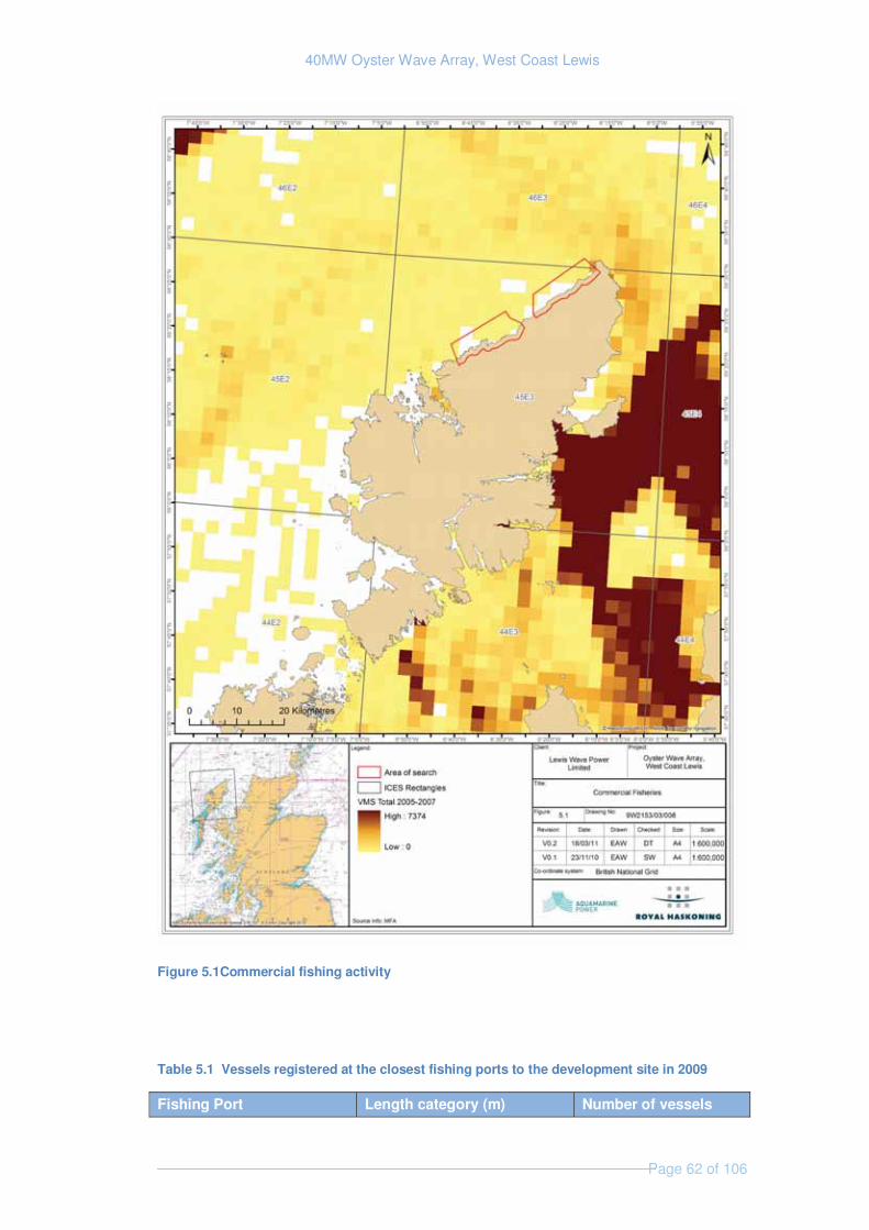
40MW Oyster Wave Array, West Coast Lewis
Page 62 of 106
Figure 5.1Commercial fishing activity
Table 5.1 Vessels registered at the closest fishing ports to the development site in 2009
Fishing Port Length category (m) Number of vessels
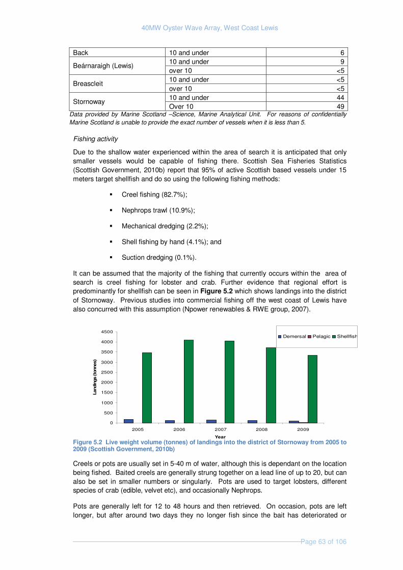
40MW Oyster Wave Array, West Coast Lewis
Page 63 of 106
Back 10 and under 6
Beárnaraigh (Lewis) 10 and under 9over 10 <5
Breascleit 10 and under <5over 10 <5
Stornoway 10 and under 44Over 10 49
Data provided by Marine Scotland –Science, Marine Analytical Unit. For reasons of confidentially Marine Scotland is unable to provide the exact number of vessels when it is less than 5.
Fishing activity
Due to the shallow water experienced within the area of search it is anticipated that only smaller vessels would be capable of fishing there. Scottish Sea Fisheries Statistics (Scottish Government, 2010b) report that 95% of active Scottish based vessels under 15 meters target shellfish and do so using the following fishing methods:
� Creel fishing (82.7%);
� Nephrops trawl (10.9%);
� Mechanical dredging (2.2%);
� Shell fishing by hand (4.1%); and
� Suction dredging (0.1%).
It can be assumed that the majority of the fishing that currently occurs within the area of search is creel fishing for lobster and crab. Further evidence that regional effort is predominantly for shellfish can be seen in Figure 5.2 which shows landings into the district of Stornoway. Previous studies into commercial fishing off the west coast of Lewis have also concurred with this assumption (Npower renewables & RWE group, 2007).
Figure 5.2 Live weight volume (tonnes) of landings into the district of Stornoway from 2005 to 2009 (Scottish Government, 2010b)
Creels or pots are usually set in 5-40 m of water, although this is dependant on the location being fished. Baited creels are generally strung together on a lead line of up to 20, but can also be set in smaller numbers or singularly. Pots are used to target lobsters, different species of crab (edible, velvet etc), and occasionally Nephrops.
Pots are generally left for 12 to 48 hours and then retrieved. On occasion, pots are left longer, but after around two days they no longer fish since the bait has deteriorated or
0
500
1000
1500
2000
2500
3000
3500
4000
4500
2005 2006 2007 2008 2009
Year
Land
ings
(ton
nes)
Demersal Pelagic Shellfish
40MW Oyster Wave Array, West Coast Lewis
Page 64 of 106
been eaten. Furthermore, any crabs and lobsters retained within them may become aggressive and fight on another causing each other damage.
Fish farms
The wider area supports many fish farms; although there are no known farms within the area of search, Loch Ròg, approximately 5 km to the south supports a number of finfish and shellfish farms (Baxter et. al., 2011).
5.2.2 Identification of Key Issues & Sensitivities
Due to the low numbers of fishing vessels likely to be using the area of search impacts to commercial fishing are anticipated to be minor. Limited access to fishing grounds and loss or damage of gear are the only effects that are likely to be significant and therefore will be assessed within the EIA(Table 6.1).
Limited access to fishing grounds: Access may be restricted during construction operation and decommissioning of the wave array. Certain types of fishing may be constrained as a result of the creation of physical obstacles (the Oyster devices and associated infrastructure).
Loss or damage to gear: The normal practice of local fishing vessels hauling fleets (strings) of creels in highly energetic wave environments raises a risk of entanglement of a fleet of creels in the wave array whilst the fleet of creels is being winched to the surface. The risk of entanglement will be low given the limited use of the area for fishing and the fact that the oyster devices will be required to be properly marked on nautical charts of the area
Obstruction to regular fishing vessel transit routes: Local, smaller vessels that may typically transit the site to reach fishing grounds may be diverted to maintain navigational safety. However given the low usage of the area a significant effect is unlikely to occur and therefore this is scoped out of the EIA (Table 6.1)
Increased congestion at piers and pontoons used by local fishermen: Depending upon where Lewis Wave Power plan to base elements of its installation operations, there is a potential for congestion at local small harbours / piers. However given the low usage of the area by commercial fishermen a significant effect is unlikely to occur and therefore this is scoped out of the EIA (Table 6.1)
Change in abundance of targeted species: The installation of a wave array within the area of search may affect the abundance of marine organisms on a very local scale (Section 4.6). However it is it is extremely unlikely that the changes in abundance will be at a level that will be seen by commercial fishermen; therefore this effect will be scoped out of the EIA (Table 6.1).
5.2.3 Approach to EIA
The EIA will firstly seek to identify the extent of the fishing activity within the development area in order to assess the potential for an adverse impact to occur. Available data already indicates that fishing effort within the development site is likely to be minimal and confined to the activities of a small number of local vessels. Currently available baseline data is on

40MW Oyster Wave Array, West Coast Lewis
Page 65 of 106
a scale that is not suited to understanding activity across the site and therefore consultation will be vital.
Impact assessment will be informed by data gathering and consultation, which will confirm the following:
� Fishing grounds within the vicinity of the development;
� Evidence and distribution of the major commercial fish and shellfish species in the area;
� The type of fishing that takes places within the area and the gear that is used, for example, potting, etc;
� Seasonality of the fishing in the area: i.e., what species are fished at certain times of year;
� Fish landings data;
� Fishing effort data (the time spent fishing within an area);
� Fishing vessel movements (if these data are readily available); and
� Value of the fishing industry to the local economy.
Data Requirement Method Data SourcesFisheries landing statistics (desk based)
Landings at local ports from the study area, fishing activity, seasonality and economic value of catches from within the site and adjacent areas will be assessed to determine the impacts to commercial fishing.
Marine Scotland – science Marine analytical unit, The outer Hebrides Inshore Fisheries Group Local Sea Fisheries Committees. ICES
Consultation pre consent (desk based and on location)
Detailed, early and well-targeted consultations with commercial and recreational fishermen, fishing organisations and the relevant local fishery management organizations will further support the baseline description of the fishing activity (in terms of fishing effort, area of activity, target species and commercial value).
Marine Scotland The Scottish Fisherman’s Federation Local Fishermen's Association(s) such as the Western Isles Fisherman's Association
Consultation post consent (desk based and on location)
A Fisheries Liaison Officer will be used to facilitate discussions with local fishermen as well as advise when surveys are taking place in order to ensure minimal disruption to fixed gear.
Local Fishermen's Association(s)
5.3 Shipping and Navigation
5.3.1 Existing Environment
Shipping and density within the region is described as low to moderate (Metoc, 2006) in relation to other UK waters. A deep water route located over five miles to the west of the area of search exists (Figure 5.3). This is the recommended route for laden tankers over

40MW Oyster Wave Array, West Coast Lewis
Page 66 of 106
10,000 gross registered tonnes (Scottish Executive, 2007). The majority of shipping in the region however, passes Lewis to the east through a recognised shipping channel referred to as the Minches.
Data collected in preparation for the Saltire prize announcement indicates that shipping density in coastal waters to the west of north Lewis (which contains the area of search) is less than 20 ships per nautical mile per year (Harald et. al., 2010). This is considered to be very low density and is due to the shallow water found in this area. Further offshore (approximately 5 km) shipping density reaches between 20 and 30 ships per nautical mile per year. As the Oyster devices will be located within shallow waters (10-20 m) they will not be positioned in any area that will be used for shipping.
There are no permanent harbours within the area of search, but there area a number of basic slipways at locations such as Siadar Bay and Labost.
The North West coast of Lewis has been categorised by the Royal Yachting Association (RYA) as a light usage area, with few recreational craft seen during summer months. The area of search is out-with any areas regarded as general sailing areas, and only as a place where day tripping and other boating activities occur. Shipping activity is therefore limited to small numbers local fisherman and recreational crafts.
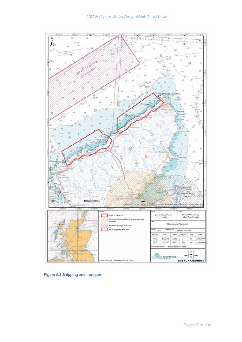
40MW Oyster Wave Array, West Coast Lewis
Page 67 of 106
Figure 5.3 Shipping and transport.
40MW Oyster Wave Array, West Coast Lewis
Page 68 of 106
5.3.2 Identification of Key Issues & Sensitivities
Although neither of the following issues are likely to cause major significant adverse impact (Table 6.1) they will both be considered in the EIA.
Collision risk: Increased vessel numbers in inshore waters off the west coast of Lewis will occur as part of the installation maintenance and decommissioning of the proposed wave array. However as very limited shipping and vessel activity occurs within this area collision risk is likely to continue to be low.
Navigational Hazards: The Oyster devices will represent a hazard to navigation within the study area. The navigational risk assessment will identify the level of risk they pose to vessels and will indicate how they should be presented on nautical charts.
Navigational Radar: It is not expected that the wave array will impact use of radar for navigation and therefore this impacts is scoped out of the EIA (Table 6.1)
5.3.3 Approach to EIA
It is standard practice to undertake a navigational Preliminary Hazard Analysis (PHA), which uses existing information on the navigational interests of the project area and details of the proposed project to scope the requirements of the full Navigational Risk Assessment (NRA). MGN 371 includes information beyond the scope of the baseline PHA assessment, giving recommendations for impact assessment and mitigating actions.
The PHA will consider:
� Shipping movements within the development area;
� Anchorages within the vicinity of the development;
� Potential search and rescue activity within the area and the types of aircraft and vessels which they may use within the vicinity of the site;
� International Maritime Organisation (IMO) approved or other adopted routing measures such as Areas to Be Avoided (TBA) or Traffic Separation Schemes;
� Marine Environmental High Risk Areas (MEHRAS);
� An awareness of Port Authority rules which may have specific requirements; and
� Water depth at high and low tides and an awareness of currents around the site.
It is expected that the scope of any NRA will reflect the low level of activity / limited navigational features across the site.
40MW Oyster Wave Array, West Coast Lewis
Page 69 of 106
Data Requirement Method Data Sources
Navigational review (desk based)
A navigation review will include consultation with relevant stakeholders e.g. MCA and Northern Lighthouse Board to assess shipping density in the area
Consultation with relevant stakeholders e.g. RYA and RNLI, The chamber of shipping, NLB, Comhairle nan Eilean Siar (Harbour Master), North west Inshore Fisheries group and local fishermen (see section 7.2, Consultation strategy)
Navigational Risk Assessment
Undertake Preliminary Hazard Analysis (PHA) to inform detailed siting of devices and agree scope of full navigation assessment, if required, with MCA in accordance with MGN 371 (formerly MGN 275).
MCA
5.4 Onshore Traffic and Transport
5.4.1 Existing Environment
The A857 is the primary trunk road connecting Stornoway with the area of search and Port of Ness to the extreme north of the area of search. This road has the ability to take standard European 40 tonne HGVs. However, as parts of the road network on Lewis is built onto peat it is unclear what density of such vehicle use could be sustained without causing road damage.
An airport is situated near Stornoway, which is the main town on Lewis, and is located on the East coast of the Island approximately 20 km south east of the area of search (Figure 5.3). A ferry also sails from Stornoway to Ullapool daily throughout the year.
5.4.2 Identification of Key Issues & Sensitivities
It is expected that the majority of the offshore works and installation equipment will be transported to site by sea, however onshore infrastructure and installation equipment will be transported overland at some point. Neither of the issues discussed below are anticipated to cause significant disruption however they will both be considered further within the EIA.
Disruption to local traffic and access: may occur during installation and maintenance of the wave array. The transport of material and equipment associated with onshore activities is likely to require some modifications to the existing road network on Northern Lewis.
Degradation of road surfaces: may occur during the installation and decommissioning as most of the road network within the area of search is unsuitable for heavy vehicles. Widening of junctions within and out-with the area of search may be necessary causing further disruption to local traffic. These effects will be mitigated by the development of a detailed project traffic management plan.
Some additional human activity in the area associated with the project may contribute to an increase in local traffic however this is not anticipated as being of sufficient scale to cause any significant disruption.
40MW Oyster Wave Array, West Coast Lewis
Page 70 of 106
5.4.3 Approach to EIA
Lewis Wave Power proposes undertaking a desk-based assessment that will present road traffic numbers / main routes within and adjacent to the area of search (obtained from Transport Scotland). The impact assessment will be based upon a comparison between this data and the expected traffic levels associated with the development through construction, operation and decommissioning. A similar approach was taken by the developers of the Siadar Wave Energy Project (which is adjacent to the area of search boundary), whereby the likely increase in traffic levels associated with the project and their receptor effects were assessed against Institute of Environmental Assessment (IEA) Guidelines (IEA, 1993). IEA Guidelines on traffic state that assessment is required where traffic movements or HGV movements increase by >30 %, or more than 10 % where there are sensitive receptors likely to be affected. Access needs for the local community in the vicinity of the onshore works will be incorporated into the EIA.
Data Requirement Method Data SourcesReview of existing conditions (desk based)
Collate data on traffic volumes and movements, main routes, road status
Transport Scotland relevant traffic studies, Western Isles Council (Comhairle nan Eilean Siar) traffic counts, Siadar Wave Energy ES, stakeholder consultation
5.5 Military Activity
5.5.1 Existing Environment
Waters to the east of Lewis are used by the Royal Navy as a submarine Practice and Exercise Area (PEXA) (Figure 5.4). Separated from the area of search by the northern tip of Leiws the PEXA area lies within approximately 2.5 km by sea from it.
A second much smaller military PEXA is located within the area of search immediately offshore from Barabhas (Figure 5.4). This is the Barvas Rifle Range located on Barvas Sands. Firing is towards a target on the shoreline at the northwest of the range. The danger area is not confined to the land based section of the range and extends past the target on the shoreline into the coastal waters. The final site of the development will be positioned so that not part of the project is within the PEXA limiting potential impacts to the MoD
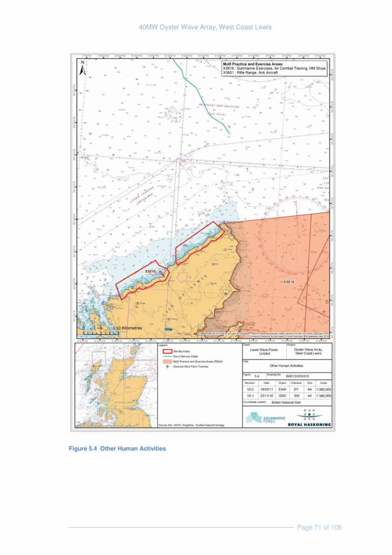
40MW Oyster Wave Array, West Coast Lewis
Page 71 of 106
Figure 5.4 Other Human Activities
40MW Oyster Wave Array, West Coast Lewis
Page 72 of 106
5.5.2 Identification of Key Issues & Sensitivities
Temporary disruption to military activities: No construction activities will be under taken within a PEXA and no long term disruption is expected. The danger areas at South Uist and Cape Wrath should be considered when planning transportation routes to the proposed development site. Confirmation is required from the MoD that no UXO is/has historically been used from this site.
5.5.3 Approach to EIA
Data Requirement Method Data Sources
Confirm status of local PEXA
Consultation with relevant stakeholders Ministry of Defence
5.6 Archaeology and Cultural Heritage
5.6.1 Existing Environment
Introduction
The archaeological assessment will cover both marine and terrestrial archaeological elements. Historic Scotland is responsible for nationally important onshore Scheduled Ancient Monuments and for the preservation of the marine archaeological resource out to the 12 nautical miles (nm). They will be consulted to obtain detailed information on the archaeological resource of the area, as will the Western Isles Council, and any relevant local archaeological societies for information on the regionally important archaeology within the area of search.
The installation of Oyster wave devices, pipeline, anchors, conversion plant, and other ancillary works could result in potential damage to any features of archaeological significance located within the vicinity of the scheme.
Relevant Legislation and Planning
Scotland’s heritage-related planning guidance and legislation is currently undergoing a period of major review. As a consequence, it is appropriate to highlight that changes, to both legislation and the planning process, are currently being made and may continue to be made over the next 5 years. This report reflected the situation as of May 2011.
The Historic Environment (Amendment) (Scotland) Act 2011 received Royal Assent on the 23rd of February 2011 this Act will amend three pieces of current primary legislation, The Historic Buildings and Monuments Act of 1953, the Ancient Monuments and Archaeology Areas Act of 1979, and the Planning (Listed Buildings and Conservation Areas)(Scotland) Act of 1997 all while protecting the core of the current system.
40MW Oyster Wave Array, West Coast Lewis
Page 73 of 106
Currently, the following key legislation is relevant to the area of search and the marine and terrestrial environment and would need to be considered during any detailed assessment:
� The Historic Buildings and Ancient Monuments Act 1953;
� Protection of Wrecks Act 1973;
� Ancient Monuments and Archaeological Areas Act 1979;
� Protection of Military Remains Act 1986;
� Merchant Shipping Act 1995; and
� Planning (Listed Buildings and Conservation Areas) (Scotland) Act 1997.
The following planning policy guidance is relevant and would need to be adhered to in relation to the proposed scheme and detailed work in related to the historic environment:
� Scottish Planning Policy 23: Planning and the Historic Environment;
� Scottish Historic Environment Policy (Historic Scotland, 2009);
� Code of Practice for Seabed Developers, Joint Nautical Archaeology Policy Committee 2006 (JNAPC);
� Historic Environment Guidance for the Offshore Renewable Energy Sector, COWRIE 2007; and
� Guidance for Assessment of Cumulative Impacts on the Historic Environment from Offshore Renewable Energy, COWRIE 2008.
Known Archaeological Sites
The initial examination of the Western Isles Sites and Monuments Record identified 62 sites within and adjacent to the proposed scheme shoreline. These are mapped in Figure 5.5, with details of each site presented in Appendix A.
The following Scheduled Monuments are located within the area of search:
� SM5395 Carnan a'Ghrodhair,souterrain
� SM5359 Teampull Pheadair,church,Swainbost
� SM5352 Dun Mara,dun
� SM5454 Loch Baravat,dun, Gabhsann
� SM3945 Teampull nan Cro'Naombh,chapel
� SM1669 Dun Borve,broch
� SM90022 Arnol, blackhouses no. 39 and no. 42 and associated croft houses
� SM3926 Teampull Eoin, chapel, graveyard & settlement,
� SM4512 Allt na Muilne,horizontal water-mills,Bragar
40MW Oyster Wave Array, West Coast Lewis
Page 74 of 106
� SM5344 Loch Raoinavat,stone circle
� SM4502 Cnoc na Moine,burial cairn,Dalmore
No World Heritage Sites, Conservation Areas, or Gardens and Designed Landscapes are located within the study area.
There are a number of listed buildings located within the area of search. These are mainly concentrated around Dail bho Dheas, Cros, Barabhas and Siabost and include the following:
� Dell, House – Grade B C(S) - 3-bay house in neglected condition;
� Dell, Muileann Nis mill - Grade B - Mid 19th century farm steading which contains large all-iron internal water wheel;
� Cross, Manse - Grade B- 2-storey version of the two Parliamentary manse stock designs;
� Cross, Church of Scotland – Grade B - One of a series of three near-identical churches, the others being at Garrabost and at Barabhas;
� Thatch-roofed Garage – Grade B - Hebridean-type thatch-roofed building;
� Thatch-roofed Block – Grade B - Hebridean-type thatch-roofed building;
� Barabhas, Church of Scotland – Grade B - One of a series of three near-identical churches, the others being at Garrabost and Cross;
� Barabhas Lodge – Grade C(S) - inn, dating from 18th or early part of 19th century;
� Barabhas, Free Church – Grade C(S) - 19th century church, tall symmetrical and rectangular-plan;
� Bragar, Whalebone Arch – Grade B - Large whalebone arch erected as gateway to a private house;
� North Shawbost, Clapper Bridge at Ngr- Grade B - 19th/early 20th century roadbridge;
� North Shawbost, Free Church- Grade C(S)- Box-type Gothic church with pointed openings;
� Shawbost Bridge – Grade C(S) - Late 19th century roadbridge; and
� Shawbost Museum – Grade C(S)- Mid/late 19th century former church, now (1991) run as a museum
No Designated wrecks are located within the offshore area of search; however data provided by the Royal Commission on the Ancient and Historical Monuments of Scotland (RCAHMS) shows that the following wrecks have been identified within area of search site:
� O Roberson
� The Maria D

40MW Oyster Wave Array, West Coast Lewis
Page 75 of 106
� Maju
� Clan Macquarrie
� Speedwell
� Breadwinner
� Horda
� Annie Gardemer
� Jean Girrel
The high energy marine environment found off the west coast of Lewis is not conducive to the conservation of wrecks and most will be rapidly broken up and dispersed. Therefore the wrecks listed above may no longer be in existence. In addition, potential wreck locations would be avoided during identification of potential development sites.
The Historic Landscape Character in the area is undefined at this stage, however, there is extensive medieval cultivation and settlement features in the land within and surrounding the area of search.
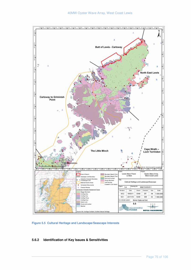
40MW Oyster Wave Array, West Coast Lewis
Page 76 of 106
Figure 5.5 Cultural Heritage and Landscape/Seascape Interests
5.6.2 Identification of Key Issues & Sensitivities
5.5
40MW Oyster Wave Array, West Coast Lewis
Page 77 of 106
During construction, there could be a number of potential impacts on the historic environment resource, which may be considered within the EIA (Table 6.1), including:
� Direct disturbance of submerged historic and prehistoric land surfaces and archaeological finds;
� Direct disturbance of terrestrial (onshore) sites and finds; and
� Direct disturbance to the visual setting of Scheduled Monuments during construction.
During the operational phase of the wave array, a number of potential impacts could arise on the historic environment resource:
� Potential indirect disturbance of submerged historic and prehistoric land surfaces and archaeological finds as a result of changes to the hydraulic and sedimentary regime;
� Direct disturbance to the visual setting of Scheduled Monuments and effects on the historic landscape character.
Overall, there are a number of historic sites within the area of search that could be directly affected by the proposed scheme, whilst the setting of a number of Scheduled Monuments could potentially be affected. Furthermore, the historic landscape character could also be adversely affected by any ground disturbance and built structures.
Not all archaeological sites, finds, and prehistoric land surfaces are identified or known of within desk-based sources. Consequently, potential disturbance to unknown sites, finds, and prehistoric land surfaces could theoretically arise during scheme construction.
5.6.3 Approach to EIA
An archaeological assessment would be undertaken to assess and mitigate against potential impacts on known and unforeseen archaeological features. This would follow a phased approach, commencing with an archaeological desk-based assessment. The table below highlights the key work to be undertaken to ensure that no significant archaeological or historical resource is affected by the proposed development.
Desk-based Assessment
An archaeological desk-based assessment (ADBA) will be undertaken, which will include the following items of work:
� Identify the known and potential archaeological resource; evaluate the importance of the sites that could be affected by the proposed scheme;
� Consider the visual impacts of the proposed scheme on the key heritage resource within the area of search (including Scheduled Monuments and Historic Landscape Character);
� Identify, in detail, past impacts on the area of search;
� Undertake a detailed assessment of the potential impacts of the proposed scheme on the archaeological resource; and

40MW Oyster Wave Array, West Coast Lewis
Page 78 of 106
� Identify the nature of any further work/surveys that may be required to fill in any data gaps.
The basis of the desk-based assessment will be the collection of relevant data from a wide number of sources to ensure that all known information is obtained and to indicate where data gaps result in insufficient knowledge of the impacts.
During the preparation of the ADBA the following will be consulted as a minimum with respect to information and potential effects of the proposed scheme:
� Scottish Natural Heritage;
� Historic Scotland;
� Western Isles Council;
� Joint Nautical Archaeology Policy Committee (JNAPC); and
� Receiver of Wreck.
Additionally, a walkover survey will be undertaken of the site and the foreshore to ascertain the archaeological potential of the areas of potential disturbance. This inspection will be accompanied by an inspection of historic assets that may be considered visually impacted by the development. This will include sites outside of the development footprint such as the Scheduled Monuments listed earlier.
Liaison will take place with Historic Scotland and the EIA landscape architects in order to identify key views that will need to be assessed in terms of potential disturbance arising from the proposed development.
The desk-based assessment, site inspection and walkover will allow the potential impacts associated with the construction and operational phases to be assessed, and will also inform the decision as to whether or not survey work is required to fully describe the archaeological baseline.
Geophysical and bathymetric surveys have been undertaken across the area of search and these existing data produced will be reviewed for anomalies and other indicators of potential archaeological interest. However, in the high energy exposed environment of the area of search, the presence of such features of interest is considered highly unlikely.
Further Work/Surveys
Following completion of the ADBA, consultation will be undertaken with the Western Isles Council and Historic Scotland with regard to specific survey that may be required to fill the data gaps identified within the ADBA. The surveys may include, but are not limited to:
� Trial excavation on landward areas if there is considered to be gaps in knowledge especially where areas have not been developed significantly in the past; and
Study Requirement Method Data Sources
Assessment of current records
Archaeological desk-based assessment using relevant guidance
Consultation with Scottish Natural Heritage, Historic Scotland, and the
40MW Oyster Wave Array, West Coast Lewis
Page 79 of 106
e.g. Institute of Field Archaeologists (2001). Consultation with relevant stakeholders.
Western Isles Council Archaeology Unit. Sites and Monuments Record; NMR, UKHO, Receiver of Wreck, BGS boreholes, historic maps, etc.
Review of existing bathymetric and geophysical data in the area of search.
Desk review Lewis Wave Power / Aspect survey of area of search.
5.7 Onshore Noise
5.7.1 Existing Environment
The area of search is situated along the sparsely populated north-western coastline of Lewis where the ambient noise climate is dominated by natural source sounds such as those produced by the Atlantic Ocean, meteorological associated effects, wildlife and watercourses. Locally the noise climate will be influenced by the small settlements that exist along this coastline including those at Labost, Brager, Arnol Siadar, High Borve, Mealabost Bhuirgh and Dail bho Dheas.
The A858 and the A857 are the only main roads in the area and they both maintain a relatively low traffic flow throughout the day, therefore their contribution to the overall acoustic environment is less than that arising through natural sources of noise (Npower renewables & RWE group, 2007). All other roads are generally single track or private with very low traffic movements. Other modes of transport including aircraft and motor boat activities do not have a discernable effect on ambient noise levels.
In terms of receptors that may be sensitive to elevated noise levels, there are several small dwellings located approximately 0.5 km – 1 km inland of the coastline throughout the area of search. The highest concentrations of which exist in the settlements listed above at the beginning of this section.
As part of the EIA for the Siadar Wave Energy Project, baseline noise conditions were assessed at several sensitive receptors (dwellings at Siadar); the major findings of which were that the dominant noise originated from the ocean and effects of the wind.
5.7.2 Identification of Key Issues & Sensitivities
Key sources of noise associated with the Oyster development include construction activity (e.g. piling, drilling, road works, heavy plant movements and operations) and traffic, gear contained within the powerhouse, and maintenance vehicles visiting the powerhouse the offshore operating devices.
Airborne noise can have an adverse impact on wildlife, human health and the perceived quality of life in a local environment, e.g., the recreational activities of a coastal community may be adversely impacted.
5.7.3 Approach to EIA
Lewis Wave Power will discuss with the Local Authority the requirement for noise survey/modelling in relation to their proposed development, and seek to use the existing data
40MW Oyster Wave Array, West Coast Lewis
Page 80 of 106
gathered as part of the Siadar wave energy project, alongside noise data gathered at Billia Croo to inform the EIA.
Lewis Wave Power will undertake a noise impact assessment, if required, during the EIA that complies with guidance laid out by several British Standards (e.g. BS 5228, BS 4142).
5.8 Tourism and Recreation
5.8.1 Existing Environment
The rugged coastline, sandy beaches and remoteness of the Western Isles are features that attract visitors to the area (Dunbar et al., 1997). According to the Outer Hebrides Tourism Update, visitors to the Western Isles grew from 180,000 in 2002 to 196,000 in 2006 (+ 8.9%). Tourism is an increasingly important industry in the Western Isles, and tourism related sectors contribute approximately 10 % of its employment.
The North West coast of Lewis includes a number of Lewis’s top tourist attractions, including the Butt of Lewis, Dun Cárlabhaigh Broch, Arnol Blockhouse, Garenin Blackhouse village and the standing stones at Calanais.
Tourism in Lewis tends to be dominated by outdoor activities including cycling, hiking, mountaineering, angling, surfing and golf. Other activities include visiting ancient monuments, archaeological sites, heritage sites, Gaelic culture and wildlife watching (Dunbar et al, 1997).
Several surfing sites are located along the north coast of Lewis. The Stormrider Guide Europe – Atlantic Islands (2007) indicates that there are three breaks within the area of search; located at Dail Mòr and Dail Beag in the southern part and Eòropaidh in the northern part. Surfing activity is also known to occur at Borve and local surfers are known to occasionally use breaks at the south of Siadar Bay.
Locally, Cárlabhaigh Angling Club offers a variety of fishing on the Abhainn Cárlabhaigh and associated lochs, while the Barabhas Estate offers salmon fishing. Trout fishing in North Lewis lochs is also very popular with many lochs offering inexpensive high quality trout fishing. No lochs widely known for their trout fishing are thought to be present within the area of search.
5.8.2 Identification of Key Issues & Sensitivities
Study Requirement Method Data Sources
Assessment of available information (desk based)
Desk-based assessment to identify sensitive receptors and noise sources/levels associated with the proposed development. Consultation with Local Authority.
Ordnance Survey maps Site visits Consultation with the Local Authority and community / landowners
Baseline survey (field survey) IF REQUIRED
Baseline noise conditions measured at sensitive receptors under various weather conditions
Commissioned noise survey
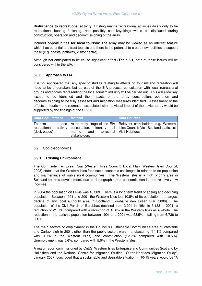
40MW Oyster Wave Array, West Coast Lewis
Page 81 of 106
Disturbance to recreational activity: Existing marine recreational activities (likely only to be recreational boating / fishing, and possibly sea kayaking) would be displaced during construction, operation and decommissioning of the array.
Indirect opportunities for local tourism: The array may be viewed as an interest feature which has potential to attract tourists and there is the potential to create new facilities to support these (e.g. coastal pathway, visitor centre).
Although not anticipated to be cause significant effect (Table 6.1) both of these issues will be considered within the EIA.
5.8.3 Approach to EIA
It is not anticipated that any specific studies relating to effects on tourism and recreation will need to be undertaken, but as part of the EIA process, consultation with local recreational groups and bodies representing the local tourism industry will be carried out. This will allow key issues to be identified and the impacts of the array construction, operation and decommissioning to be fully assessed and mitigation measures identified. Assessment of the effects on tourism and recreation associated with the visual impact of the device array would be supported by the findings of the SLVIA.
Data Requirement Method Data Sources
Tourism and recreational activity (desk based)
At an early stage of the EIA consultation, identify all marine and terrestrial stakeholders
Relevant stakeholders e.g. Western Isles Council; Visit Scotland statistics; Visit Hebrides
5.9 Socio-economics
5.9.1 Existing Environment
The Comhairle nan Eilean Siar (Western Isles Council) Local Plan (Western Isles Council, 2008) states that the Western Isles face socio-economic challenges in relation to de-population and maintenance of viable rural communities. The Western Isles is a high priority area in Scotland for new development, due to demographic and economic trends, and relatively low incomes.
In 2004 the population on Lewis was 18,383. There is a long term trend of ageing and declining population. Between 1991 and 2001 the Western Isles lost 10.5% of its population, the largest decline of any local authority area in Scotland (Comhairle nan Eilean Siar, 2006). The population of the Civil Parish of Barabhas declined from 3,994 in 1981 to 3,133 in 2001, a reduction of 21.6%, compared with a reduction of 16.8% in the Western Isles as a whole. The reduction in the parish’s population between 1901 and 2001 was 53.5% – falling from 6,736 to 3,133.
The main sectors of employment in the Council’s Sustainable Communities area of Westside and Cárlabhaigh in 2001, other than the public sector, were manufacturing (14.1% compared with 9.0% in the Western Isles) and construction (12.2% compared with 10.5%). Unemployment was 5.6%, compared with 5.0% in the Western Isles.
A major report commissioned by CnES, Western Isles Enterprise and Communities Scotland by Hallaitken and the National Centre for Migration Studies, “Outer Hebrides Migration Study”, January 2007, concluded that a sustainable and desirable situation in 10-15 years would be “A

40MW Oyster Wave Array, West Coast Lewis
Page 82 of 106
stable and growing economy based around a skilled workforce adding value to the wealth of natural resources (food production, renewable energy, crafts).”
5.9.2 Identification of Key Issues & Sensitivities
Increased local employment opportunities and revenues would arise from the installation of a wave array during the construction, maintenance and decommissioning stages. In Scotland it is anticipated that renewable energy projects could potentially create tens of thousands of jobs (Scottish Government, 2009). Pre-installation work such as site specific surveys could also be carried out by suitably qualified local people.
Increased public spend would occur with the increase in human activity in the area. Personnel including engineers and scientists brought in to work on the array project would require food and accommodation throughout the year.
5.9.3 Approach to EIA
A desk-based socio-economic assessment will support the EIA. It will consider impacts of the development in both its construction phase and its period of operation. The assessment will make use of available data relating to local conditions (e.g. employment rates and trends) and data supplied by Lewis Wave Power relating to their project (e.g. project capital costs, construction / maintenance requirements, construction duration).
Net benefits will be assessed, and quantified where possible, for:
� The local area (north to the butt of Lewis and south to Cárlabhaigh); and
� The Western Isles as a whole.
The assessment will consider:
� Energy supplied by the development;
� Employment and income benefits from the work that will have been undertaken during the design and construction phase;
� Employment and income benefits associated with the operation and maintenance of the facility;
� Potential economic benefits from tourism generated by the project;
� Recreational effects (positive and negative); and
� Other identifiable local benefits.
Data Requirement Method Data SourcesExisting socio-economic conditions (desk based)
Collate and review available socio-economic data through desk-based research and consultation and undertake economic analysis using appropriate multipliers
Western Isles Council; Scottish Enterprise
Question 4 to Reader:

40MW Oyster Wave Array, West Coast Lewis
Page 83 of 106
Do the studies proposed for assessment of effects on the human environment look appropriate and complete?
5.10 Cumulative Effects
The EIA Regulations require that potential cumulative effects are taken into account within the project EIA. Cumulative effects may be understood as “incremental effects of an action...” arising “from individually minor but collectively significant actions”. The EIA will consider how Lewis Wave Power’s proposed development may interact with other ongoing and planned projects and activities.
In terms of proposed developments in the vicinity of the site, Lewis Wave Power is aware of two possible onshore wind farm developments (the Stornoway wind farm and the Eishken wind farm) and of a wave energy project at Siadar (RWE group and NPower renewables, 2007).
In terms of ongoing activities, it is possible that fisheries may interact with the proposed development to result in cumulative effects.
Question 5 to Reader:
Are you aware of any proposed developments or activities with which the proposed Oyster development might interact to result in cumulative effects?

40MW Oyster Wave Array, West Coast Lewis
Page 84 of 106
6. CONCLUSION
Each potential receptor has been assessed in Section 5 for potential impacts from the proposed development, and the potential significance of those impacts.
Table 6.1 specifies whether the potential impacts identified in this scoping study need to be considered further within the Lewis Wave Power EIA. These impacts are categorised as significant, potentially significant or unknown significance. Impacts to be considered during the EIA have been highlighted in bold. Potential impacts deemed to be of no significance have been scoped out of the EIA at this stage.
In addition to the site specific environmental impacts outlined below, there are also significant beneficial impacts associated with the development of renewable energy technologies, in terms of reducing carbon emissions and combating climate change. These will also be considered within the EIA.
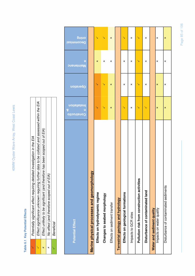
40M
W O
yste
r W
ave
Arr
ay, W
est C
oast
Lew
is
P
age
85 o
f 106
Tab
le 6
.1 K
ey P
ote
ntia
l Eff
ects
�
P
oten
tially
sig
nific
ant e
ffect
req
uirin
g de
taile
d in
vest
igat
ion
in th
e E
IA
�
E
ffect
sig
nific
ance
unk
now
n re
quiri
ng fu
rthe
r da
ta to
be
colla
ted
and
asse
ssed
with
in th
e E
IA
�
E
ffect
unl
ikel
y to
be
sign
ifica
nt (
and
ther
efor
e ha
s be
en s
cope
d ou
t of E
IA)
�
N
o ef
fect
(an
d th
eref
ore
scop
ed o
ut o
f EIA
)
�
B
enef
icia
l P
ote
nti
al E
ffec
t
Construction & Installation
Operation
Maintenance
Decommissioning
Mar
ine
ph
ysic
al p
roce
sses
an
d g
eom
orp
ho
log
y
Eff
ects
on
hyd
rod
ynam
ic r
egim
e �
�
�
�
Ch
ang
es t
o s
eab
ed m
orp
ho
log
y �
�
�
�
Eff
ects
on
sedi
men
t tra
nsfe
r �
�
�
�
Ter
rest
rial
geo
log
y an
d h
ydro
log
y
Eff
ects
on
geo
log
ical
fo
rmat
ion
s �
�
�
�
Impa
cts
to G
CR
site
s �
�
�
�
Po
lluti
on
ris
k fr
om
co
nst
ruct
ion
act
ivit
ies
�
�
�
�
Dis
turb
ance
of
con
tam
inat
ed la
nd
�
�
�
�
Wat
er a
nd
sed
imen
t q
ual
ity
Impa
cts
on w
ater
qua
lity
�
�
�
�
Dis
turb
ance
of c
onta
min
ated
sed
imen
ts
�
�
�
�
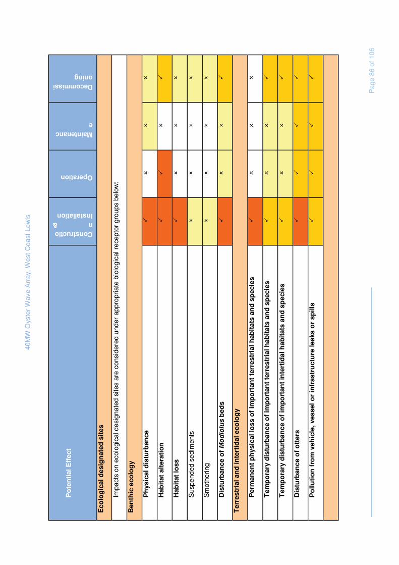
40M
W O
yste
r W
ave
Arr
ay, W
est C
oast
Lew
is
P
age
86 o
f 106
Po
ten
tial
Eff
ect
Construction & Installation
Operation
Maintenance
Decommissioning
Eco
log
ical
des
ign
ated
sit
es
Impa
cts
on e
colo
gica
l des
igna
ted
site
s ar
e co
nsid
ered
und
er a
ppro
pria
te b
iolo
gica
l rec
epto
r gr
oups
bel
ow:
Ben
thic
eco
log
y
Ph
ysic
al d
istu
rban
ce
�
�
�
�
Hab
itat
alt
erat
ion
�
�
�
�
Hab
itat
loss
�
�
�
�
Sus
pend
ed s
edim
ents
�
�
�
�
Sm
othe
ring
�
�
�
�
Dis
turb
ance
of M
od
iolu
s b
eds
�
�
�
�
Ter
rest
rial
an
d in
tert
idal
eco
log
y
Per
man
ent
ph
ysic
al lo
ss o
f im
po
rtan
t te
rres
tria
l hab
itat
s an
d s
pec
ies
�
�
�
�
Tem
po
rary
dis
turb
ance
of
imp
ort
ant
terr
estr
ial h
abit
ats
and
sp
ecie
s �
�
�
�
Tem
po
rary
dis
turb
ance
of
imp
ort
ant
inte
rtid
al h
abit
ats
and
sp
ecie
s �
�
�
�
Dis
turb
ance
of
ott
ers
�
�
�
�
Po
lluti
on
fro
m v
ehic
le, v
esse
l or
infr
astr
uct
ure
leak
s o
r sp
ills
�
�
�
�
40M
W O
yste
r W
ave
Arr
ay, W
est C
oast
Lew
is
P
age
87 o
f 106
Po
ten
tial
Eff
ect
Construction & Installation
Operation
Maintenance
Decommissioning
Orn
ith
olo
gy
Dis
turb
ance
or
dis
pla
cem
ent
du
e to
hu
man
act
ivit
y an
d n
ois
e �
�
�
�
Co
llisi
on
of
div
ing
bir
ds
wit
h t
he
dev
ice
�
�
�
�
Lo
ss o
f p
ote
nti
al f
ora
gin
g h
abit
at a
nd
fo
od
so
urc
es
�
�
�
�
Mar
ine
mam
mal
s
Dis
turb
ance
from
incr
ease
d hu
man
act
ivity
�
�
�
�
No
ise
and
vib
rati
on
dis
turb
ance
�
�
�
�
Co
llisi
on
�
�
�
�
Bar
rier
eff
ects
�
�
�
�
Acc
iden
tal r
elea
se o
f con
tam
inan
ts
�
�
�
�
Fis
h a
nd
sh
ellf
ish
res
ou
rces
Ph
ysic
al d
istu
rban
ce
�
�
�
�
No
ise
and
vib
rati
on
dis
turb
ance
�
�
�
�
Lo
ss o
f h
abit
at
�
�
�
�
Sus
pend
ed s
edim
ents
�
�
�
�
Incr
ease
in d
iver
sity
/nu
mb
er o
f in
div
idu
als
�
�
�
�
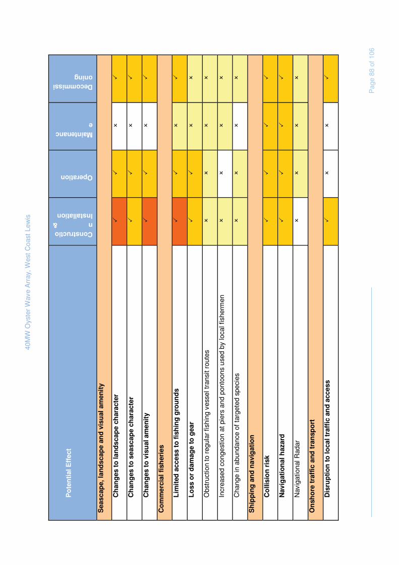
40M
W O
yste
r W
ave
Arr
ay, W
est C
oast
Lew
is
P
age
88 o
f 106
Po
ten
tial
Eff
ect
Construction & Installation
Operation
Maintenance
Decommissioning
Sea
scap
e, la
nd
scap
e an
d v
isu
al a
men
ity
Ch
ang
es t
o la
nd
scap
e ch
arac
ter
�
�
�
�
Ch
ang
es t
o s
easc
ape
char
acte
r �
�
�
�
Ch
ang
es t
o v
isu
al a
men
ity
�
�
�
�
Co
mm
erci
al f
ish
erie
s
Lim
ited
acc
ess
to f
ish
ing
gro
un
ds
�
�
�
�
Lo
ss o
r d
amag
e to
gea
r �
�
�
�
Obs
truc
tion
to r
egul
ar fi
shin
g ve
ssel
tran
sit r
oute
s
�
�
�
�
Incr
ease
d co
nges
tion
at p
iers
and
pon
toon
s us
ed b
y lo
cal f
ishe
rmen
�
�
�
�
Cha
nge
in a
bund
ance
of t
arge
ted
spec
ies
�
�
�
�
Sh
ipp
ing
an
d n
avig
atio
n
Co
llisi
on
ris
k �
�
�
�
Nav
igat
ion
al h
azar
d
�
�
�
�
Nav
igat
iona
l Rad
ar
�
�
�
�
On
sho
re t
raff
ic a
nd
tra
nsp
ort
Dis
rup
tio
n t
o lo
cal t
raff
ic a
nd
acc
ess
�
�
�
�

40M
W O
yste
r W
ave
Arr
ay, W
est C
oast
Lew
is
P
age
89 o
f 106
Po
ten
tial
Eff
ect
Construction & Installation
Operation
Maintenance
Decommissioning
Deg
rad
atio
n o
f ro
ad s
urf
aces
�
�
�
�
Mili
tary
act
ivit
y
Tem
po
rary
dis
rup
tio
n t
o m
ilita
ry a
ctiv
itie
s �
�
�
�
Arc
hae
olo
gy
and
cu
ltu
ral h
erit
age
Dir
ect
dis
turb
ance
of
sub
mer
ged
his
tori
c an
d p
reh
isto
ric
lan
d s
urf
aces
an
d
arch
aeo
log
ical
fin
ds
�
�
�
�
Dis
turb
ance
of
terr
estr
ial (
on
sho
re)
site
s an
d f
ind
s �
�
�
�
Dis
turb
ance
to
th
e vi
sual
set
tin
g o
f S
ched
ule
d M
on
um
ents
. �
�
�
�
On
sho
re n
ois
e
No
ise
dis
turb
ance
�
�
�
�
To
uri
sm a
nd
rec
reat
ion
Dis
turb
ance
to
rec
reat
ion
act
ivit
y �
�
�
�
Ind
irec
t o
pp
ort
un
itie
s fo
r lo
cal t
ou
rism
�
�
�
�
So
cio
eco
no
mic
s
Incr
ease
d lo
cal e
mp
loym
ent
op
po
rtu
nit
ies
and
rev
enu
es
�
�
�
�
Incr
ease
d p
ub
lic s
pen
d
�
�
�
�

40M
W O
yste
r W
ave
Arr
ay, W
est C
oast
Lew
is
P
age
90 o
f 106
Qu
esti
on
6 t
o R
ead
er:
Hav
e th
e m
ost
likel
y an
d si
gnifi
cant
effe
cts
been
iden
tifie
d th
roug
h th
is a
naly
sis?
Are
the
re a
ny o
ther
s th
at s
houl
d be
con
side
red
for
incl
usio
n in
the
fu
ll as
sess
men
t pro
cess
and
if s
o w
hy?

40MW Oyster Wave Array, West Coast Lewis
Page 91 of 106
7. FUTURE PROGRAMME
7.1 EIA Process
An Environmental Impact Assessment will be required to support the consent applications associated with the proposed Oyster development. Table 7.1 below identified the main stages of the EIA process that Lewis Wave Power will follow.

40MW Oyster Wave Array, West Coast Lewis
Page 92 of 106
Table 7.1 Stages of the EIA process
Stage Task Aim/objective Work/output (examples)
Scoping Scoping study
To identify the potentially significant direct and indirect impacts of the proposed development
Targets for specialist studies (e.g. hydrodynamic studies, sediment quality)
EIA
Primary data collection
To characterise the existing environment
Background data including existing literature and specialist studies
Specialist studies
To further investigate those environmental parameters which may be subject to potentially significant effects
Specialist reports
Impact assessment
To evaluate the existing environment, in terms of sensitivity
To evaluate and predict the impact (i.e. magnitude) on the existing environment
To assess the significance of the predicted impacts
Series of significant adverse and beneficial impacts
Mitigation measures
To identify appropriate and practicable mitigation measures and enhancement measures
The provision of solutions to minimise adverse impacts as far as possible Feedback into the design process, as applicable
Environmental Statement
Production of the Environmental Statement in accordance with EIA guidance Including a Non Technical Summary (NTS).
Environmental Statement
Four main volumes:
• NTS
• Written statement
• Appendices
• Figures
Pre-Application Consultation
Advertising of application for licensing must occur at least 12 weeks prior to submission of joint s36 Application
Joint s36/Licence Application (if applicable)
Post submission Liaison and consultation to resolve matters or representations/objections
Addendum to ES
EIA Consent Decision
40MW Oyster Wave Array, West Coast Lewis
Page 93 of 106
Environmental Statement
The findings of the EIA are presented in a written Environmental Statement (ES). It is proposed at this stage that the ES will comprise a single document combining text and graphics with a separate Non-Technical Summary of the information contained in the ES. Detailed specialist reports will be available as Technical Appendices where appropriate.
It is proposed the text of the Environmental Statement will be structured as follows.
Introductory Chapters
� Overview of Renewable Energy
� An introduction to renewable energy development and in particular, wave power will be outlined. It will give a short overview of the wave resource in Scotland, in particular around Lewis, and will outline the potential benefits of the development in terms of reduced emissions.
� Overview of EIA Methodology
� Will include an overview of the impact assessment methodology used for the EIA process including scoping and consultation and the identification of key environmental effects.
� Site Selection Process
� A description of the site selection process for the Oyster array will be outlined. It will describe the main alternatives studied and the main reasons for the choice of this site, taking into account the environmental effects. It will describe the way in which mitigation of environmental effects has been considered during site design, layout and the EIA process.
� Project Description
� Details of the site and a description of the proposed Oyster array will be discussed. This will include details of the size, layout and design of the site and associated onshore/offshore infrastructure. This chapter will also outline the construction, installation, operational, maintenance and decommissioning requirements of the project.
� Policy and Legislation
� This section will present an overview of the relevant statutory planning guidance and Development Plan policies which apply to the proposed development.
EIA Results
� Physical Parameters
• Marine Physical Processes and Geomorphology;
• Terrestrial Geology and Hydrology;
� Biological Parameters
• Benthic Ecology;

40MW Oyster Wave Array, West Coast Lewis
Page 94 of 106
• Terrestrial and Intertidal Ecology;
• Ornithology;
• Marine Mammals;
• Fish and Shellfish;
• Designated sites to be included in the relevant sections;
� Human Parameters
• Seascape, Landscape and Visual Amenity;
• Commercial Fisheries;
• Shipping and Navigation;
• Onshore Traffic and Transport;
• Military Activity;
• Archaeology and Cultural Heritage;
• Onshore Noise;
• Tourism and Recreation; and
• Socio-economics.
Each topic chapter will describe the approach taken to impact assessment. This will include an outline of relevant consultations undertaken, documentation studied and the means of defining the area of search for that topic. Should there be any difficulties (technical deficiencies or lack of know-how) encountered in compiling the required information, this will be noted. The existing baseline conditions for the topic will then be described. An assessment will then be made of the nature, magnitude, duration and significance of the likely effects of the construction, installation, operation, maintenance, and decommissioning of the proposed development on the topic.
Mitigation measures to avoid minimise or remedy the predicted effects, where practical will be outlined. An assessment will be made of the significance of the likely residual effect, following mitigation.
Potential cumulative effects will be considered within each EIA topic chapter.
Environmental Management Framework
Where elements of uncertainty remain regarding predicted effects (as part of the full EIA exercise) a monitoring programme may be required. Any requirements for monitoring will be discussed with the relevant regulatory authority and committed to as part of the EIA consultation process. It would be expected that monitoring commitments would become subsequent consent conditions.
40MW Oyster Wave Array, West Coast Lewis
Page 95 of 106
7.2 Consultation strategy
Lewis Wave Power is aware of the need for effective public participation throughout the consenting process and of the following legislative requirements and core guidance:
� The Public Participation Directive (PPD) (Directive 2003/35/EC) was issued by the European Commission in order to provide members of the public with opportunities to participate in the consenting and ongoing regulation of certain categories of activities within Member States. The Directive makes specific changes to the way in which EIA is undertaken, and the EIA Directive4 has been amended to incorporate these requirements. The PPD has also amended the Electricity Works (Environmental Impact Assessment) Regulations 2000 (“the Principal Regulations”).
� Planning Advice Note (PAN) 81 was released by the Scottish Executive in 2007 to provide guidance to local authorities and developers when engaging communities through the planning process.
Lewis Wave Power has already commenced informal consultation with a number of statutory bodies and local stakeholders. The main aims of their consultation strategy are as follows:
� To inform all interested parties about the proposed project, its location, scale and extent and the work and studies that are being undertaken (where necessary methodologies for studies will have been discussed and agreed with statutory agencies);
� To identify the need and benefits of the project and explaining the effects of different phases on particular groups;
� To provide clear opportunities for the public and other interests (e.g. fishermen, recreational sailors, local coastal residents) to ask questions and raise issues and concerns; and
� To ensure continued communication throughout the process to both update the public on progress and, more importantly, endeavour to resolve concerns initially voiced.
4 Council Directive 85/337 on the effects of certain public and private projects on the environment as amended by 97/11/EC (and 2003/35/EC)

40MW Oyster Wave Array, West Coast Lewis
Page 96 of 106
List of Consultees
Table 7.2 identifies the authorities, groups and organisations that will be consulted as part of the EIA process. It is important to note that this list is not exhaustive and that it is likely to expand as the EIA progresses. Those organisations highlighted in bold have been consulted during the initial pre-submission Scoping phase.
Table 7.2 Consultee List
Consultee
Association of Salmon Fisheries Board
British Surfing Association
British Telecom
Chamber of Shipping
Chamber of Shipping
Civil Aviation Authority
Comhairle nan Eilean Siar
Defence Estates
Department for Energy and Climate Change
Health and Safety Executive
Historic Scotland
Joint Nature Conservation Committee
Joint Radio Company
Landowners (e.g. Barvas Estate, Galson Estate Trust)
Local Councillors
Marine Conservation Society
Marine Safety Forum
Marine Scotland – Fisheries Compliance, Stornoway
Marine Scotland – Licensing and Operations Team
Maritime and Coastguard Agency
Ministry of Defence
National Air Traffic Services
Northern Lighthouse Board
Royal National Lifeboat Institution (Stornoway)
Royal Society for the Protection of Birds
Royal Yachting Association
Scottish Canoe Association
Scottish Coastal Forum
Scottish Environment Protection Agency
Scottish Fisheries Protection Agency
Scottish Fishermen’s Federation
Scottish Fishermen’s Organisation
Scottish Natural Heritage
Scottish Water
Scottish Wildlife Trust
Sea Fish Industry Authority

40MW Oyster Wave Array, West Coast Lewis
Page 97 of 106
Consultee
Sea Mammal Research Unit
The Crown Estate
The Royal Yachting Association
Transport Scotland – Ports and Harbours
Transport Scotland – Trunk Road and Bus Operations
Western Isles District Salmon Fisheries Board
Western Isles Fisheries Trust
Western Isles Fishermen’s Association
Questions 8 and 9 to Reader:
Does the proposed list of consultees reflect the range of stakeholders that should be considered for this project?
Are there any other sources of key environmental information which should be consulted?
7.3 Mitigation and Monitoring
This scoping phase identifies potential direct and indirect impacts associated with the potential development on Lewis prior to the implementation of appropriate mitigation. Mitigation measures will be identified during the next stages of the EIA process and will be informed through stakeholder consultation and specific surveys and studies, along with best practice industry guidance for renewable and marine and coastal developments. APL are committed to considering current best practice to minimise the risk of adverse impact to the physical, biological or social environments on site and in the surrounding area. These include, but are not limited to:
� Timings of works to avoid sensitive times, such as breeding or migratory seasons of important species, unsociable hours for local residents.
� Siting of development to avoid sensitive or protected areas, species or habitats in both marine and terrestrial environments;
� Use of low toxicity compounds during construction, operation and maintenance,; and
� Integration with the local community such as local consultation, employment where practical for local residents, and provision of bespoke transport for islanders to attend exhibitions or events related to the proposed development.
The proposed development will also draw on key knowledge from the wet renewable industry and the studies (such as underwater noise, onshore noise and wildlife interaction) completed on the existing demonstration deployment of Oyster 1 at EMEC to inform potential effects and possible mitigation.

40MW Oyster Wave Array, West Coast Lewis
Page 98 of 106
Pre construction baseline monitoring for ornithology and marine mammals is already underway, using a methodology developed specific to the site in consultation with SNH, to capture both a full overwintering and breeding bird season over a 12 month period, and baseline information of the local benthos will also be collected to inform both micro-siting of the devices and potential adverse impacts. A full and robust environmental monitoring programme is under development through consultation with key stakeholders, to gather baseline data where appropriate to inform on the existing environment, and to improve understanding of the potential interactions of the proposed development during construction and operation with the physical, biological and social environments.
8. SCOPING QUESTIONS
A number of questions have been posed to readers throughout this document. We would be grateful if you could consider these in your scoping response, making any additional comments as necessary.
8.1 Scoping questions for all stakeholders to consider
1. Have all the regulatory requirements that the project should be taking into account been identified?
2. Do the studies proposed for assessment of effects on the physical environment look appropriate and complete?
3. Do the studies proposed for assessment of effects on the biological environment look appropriate and complete?
4. Do the studies proposed for assessment of effects on the human environment look appropriate and complete?
5. Are you aware of any proposed developments or activities with which the proposed Oyster development may interact to result in cumulative effects?
6. Have the most likely and significant effects been identified through this analysis? Are there any others that should be considered for inclusion in the full assessment process and if so why?
7. Does the proposed list of consultees reflect the range of stakeholders that should be considered for this project?
8. Are there any other sources of key environmental information which should be consulted?
40MW Oyster Wave Array, West Coast Lewis
Page 99 of 106
9. REFERENCES
Anchor Environmental (2003) Literature review of effects of resuspended sediments due to dredging operations: Prepared for Los Angeles Contaminated Sediments Task Force
APL-RD.RA.04-REP-0013 Aquamarine Power Limited (2010) “Impact of APL 10 MW Site on Siadar Wave Energy Development” Aquamarine Power Limited (2010) Oyster 2 Project: underwater noise impact assessment
Aspect Land and Hydrographic surveys, 2010, Site Investigation Surveys Siadar to Bragar Isle of Lewis, Scotland. Final report A4655
Baker H, Stroud DA, Aebischer NJ, Cranswick PA, Gregory RD, McSorley CA, Noble DG and Rehfisch MM (2006). Population estimates of birds in Great Britain and the United Kingdom. British Birds, 99: 25-44.
Barne, J.H., Robson, C.F., Kaznowska, S.S., Doody, J.P., Davidson, N.C., & Buck, A.L., eds. 1997. Coasts and seas of the United Kingdom. Regions 15 & 16. North-west Scotland: the Western Isles and west Highland. Peterborough, Joint Nature Conservation Committee. (Coastal Directories Series.)
Baxter, J.M., Boyd, I.L., Cox, M., Donald, A.E., Malcolm, S.J., Miles, H., Miller, B., Moffat, C.F., (Editors), 2011. Scotland's Marine Atlas: Information for the national marine plan. Marine Scotland, Edinburgh. pp. 191
Benson, JF, Scott, KE, Anderson, C, Macfarlane, R, Dunsford, H. And Turner K., (2004). Landscape Capacity Study for Onshore Wind Energy Development in the Western Isles. Scottish Natural Heritage Commissioned Report No. 042 (ROAME No. F02LC04). This refines the existing LCA No 92 to take account of coastal areas. See: http://www.snh.org.uk/pdfs/publications/commissioned_reports/ReportNo042A.pdf.
BGS (2005). Britain beneath our feet. Available at: http://www.bgs.ac.uk/atlas/
British Geological Survey (BGS) (2004). A GIS of aquifer productivity in Scotland: explanatory notes. Commissioned Report CR/04/047N
COWRIE (2008) Guidance for Assessment of Cumulative Impacts on the Historic Environment from Offshore Renewable Energy.
COWRIE (2007). Historic Environment Guidance for the Offshore Renewable Energy Sector.
Clark, J., Dolman, S.J. and Hoyt, E. 2010. Towards Marine Protected Areas for Cetaceans in Scotland, England and Wales: A scientific review identifying critical habitat with key recommendations. Whale and Dolphin Conservation Society, Chippenham, UK, 178pp
Comhairle nan Eilean Siar (2006) Western Isles Local Plan Strategic Environmental Assessment Scoping Report. Available at: http://www.w-isles.gov.uk/localplanning/documents/Finalised%20Western%20Isles%20SEA%20Scoping%20Report%2026%2004%2006.pdf. Accessed: December 2010
Dunbar MJ, Fowler SL, Fuller I & Irvine, M (1997). Chapter 9.7. Leisure and tourism. In: Coasts and seas of the
United Kingdom. Regions 15 and 16. North-west Scotland: The Western Isles and west Highland, ed. By Barne

40MW Oyster Wave Array, West Coast Lewis
Page 100 of 106
JH, Robson CF, Kaznowska SS, Doody JP, Davidson NC and Buck AL. 162-168. Peterborough, Joint Nature
Conservation. Committee. (Coastal Directories Series).
Gardiner, R., & Egglishaw, H. (1986). Map of the distribution in Scottish rivers of the Atlantic salmon Salmo salar L. Edinburgh, Scottish Office Agriculture, Environment and Fisheries Department. (SOAEFD Publication A.)
Gubbay, S. 1988. Coastal directory for marine nature conservation. Ross-on-Wye, Marine Conservation Society.
Harald, M., Aires,C., Davis,I. 2010. Scottish Marine and freshwater science volume 1 No. 18; further Scottish leasing round (Saltire prize projects): regional locational guidance September 2010 available at: www.scotland.gov.uk/publications/2010/09/17095123/0. Accessed: December 2010
Hill, M., Briggs, J., Minto, P., Bagnall, D., Foley, K., and Williams, A. (2001). Guide to Best Practice in Seascape Assessment. Maritime Ireland / Wales INTERREG 1994 – 1999. Guide to Best Practice in Seascape Assessment Countryside Council for Wales, Brady Shipman Martin and University College Dublin, (2001), for CCW. http://www.ccw.gov.uk/pdf/Guide-to-best-practice-in-seascape-assessment.pdf
Historic Scotland, (2009). Scottish Historic Environment Policy
Hunterian Museum (2010). Scottish Geology. Available at: http://scottishgeology.com. Accessed: December 2010
Inger.R, Attrill.M.J, Bearhop.S, Broderick.A.C, Grecian.W.J, Hodgson.D,J, Mills. C, Sheehan. E, Votier. S.C, Witt.M.J, GodleyB.J (2009) Marine renewable energy: potential benefits to biodiversity? An urgent call for research. Journal of Applied Ecology. Journal of Applied Ecology. Volume 46, Issue 6, pp 1145–1153.
Institute of Environmental Assessment (IEA 1993), Guidelines for the Environmental Assessment of Road Traffic, 1993, Institute of Environmental Assessment.
Institute of Ecology and Environmental Management (IEEM) (2011) Guidelines for preliminary Ecological appraisal.
Institute of Ecology and Environmental Management (IEEM) (2010) Guidelines for Ecological Impact Assessment in Britain and Ireland, Marine and Coastal.
Institute of Ecology and Environmental Management (IEEM), 2006 guidelines for ecological impact assessment in the United Kingdom
JNAPC (2006) Code of Practice for Seabed Developers, Joint Nautical Archaeology Policy Committee
JNCC 2004. Vertebrate species: mammals. Available at:
http://www.jncc.gov.uk/ProtectedSites/SACselection/species.asp?FeatureIntCode=S1355. Accessed: December 2010
Kruuk, H., (1996). Wild Otters, Predation and Populations, Oxford University Press, Oxford, England.

40MW Oyster Wave Array, West Coast Lewis
Page 101 of 106
Linley, E.A.S, Wilding, T.A, Black, K.D, Hawkings, A.J.S and Mangi, S. 2007. Review of the reef effects of offshore wind farm structures and their potential for enhancement and mitigation. Report from PLM Applications Ltd to the DTI.
Magic http://www.magic.gov.uk
Marine Scotland (2009). Simplification of Marine Renewables consents – Process Mapping. SOPRA
Marine Scotland (2010). Marine (Scotland) Act, as accepted 10th March 2010.
Maritime and Coastguard Agency (2009a). MGN 371: Offshore Renewable Energy Installations (OREIs) - Guidance on UK Navigational Practice, Safety and Emergency Response Issues.
Maritime and Coastguard Agency (2009b) . MGN 372: Offshore Renewable Energy Installations (OREIs) - Guidance to Mariners operating in the vicinity of UK OREIs.
Maritime and Coastguard Agency’s (MCA) Marine General Notice MGN 371(M+F) - Proposed Offshore Renewable Energy Installations (OREI) – Guidance on Navigational Safety Issues
Metoc 2006, Technical Report on the Other Users of the Sea 7 area for the DTI
National Biodiversity Network (2010). NBN Gateway. Available at: http://data.nbn.org.uk/gridMap/gridMap.jsp?allDs=1&srchSpKey=NBNSYS0000040787
NBN gateway source: http://data.nbn.org.uk. Accessed: December 2010
Nedwell, J., Edwards, B., Turnpenny, A, & Gordon, J., (2004). Fish and Marine Mammal Audiograms: A summary of available information. Subacoustech Report ref: 534R0214
Nedwell, J., Langworthy, J., and Howell, D., (2003) Assessment of sub-sea acoustic noise and vibration from offshore wind turbines and its impact on marine wildlife; initial measurements of underwater noise during construction of offshore wind farms, and comparison with background noise. Subacoustec report to COWRIE, reference 544R0424. May 2003. Subacoustech Ltd, Chase Mill, Winchester Road, Bishop’s Waltham, Hampshire S032 1AH, UK. 55pp.
Nedwell, R., & Brooker, A,. (2008). Measurement and assessment of background underwater noise and its comparison with noise from pin pile drilling operations during installation of the SeaGen tidal turbine device, Strangford Lough. Subacoustech Report No. 724R0120 to COWRIE Ltd. ISBN: 978-0-9557501-9-9. Available at: http://www.offshorewindfarms.co.uk/Assets/Final%20report_26%2001%2009.pdf
NetRegs. http://www.netregs.gov.uk/.
OSPAR Convention for the Protection of the Marine Environment of the North-East Atlantic (2008). OSPAR List of Threatened and/or Declining Species and Habitats (Reference Number: 2008-6)5
Parvin, S., Nedwell, J., & Workman, R. (2006) Underwater noise impact modelling in support of the London Array, Greater Gabbard and Thanet Offshore Wind Farms. Subacoustech report No. 710R0517
5 Replaces agreement 2004-6. See OSPAR 08/24/1, §7.12

40MW Oyster Wave Array, West Coast Lewis
Page 102 of 106
Popper, A,. & Hastings, M. (2009). The effects of anthropogenic sources of sound on fishes. Journal of Fish Biology 75, 455–489
Powell, H.T., Holme, N.A., Knight, S.J.T., Harvey, R., Bishop, G., & Bartrop, J. 1979. Survey of the littoral zone of the coast of Great Britain: 3. Shores of the Outer Hebrides. Nature Conservancy Council, CSD Report, No. 272.
Reid J.B., Evans, P.G.H. and Northridge, S.P. (2003). Atlas of Cetacean distribution in north west European water. Joint Nature Conservation Committee.
Richards, J. (1998). Western Isles landscape character assessment. Scottish Natural Heritage Review No. 92
RWE (group) Npower renewables and (2007) Siadar Wave Energy Project Environmental Statement
SCOS (2009). Scientific Advice on Matters Related to the Management of Seal Populations, 2009. Available at: http://www.smru.st-and.ac.uk/documents/341.pdf. Accessed: December 2010
Scott, K.E., Anderson, C., Dunsford, H., Benson, J.F. and MacFarlane, R. (2005). An assessment of the sensitivity and capacity of the Scottish seascape in relation to offshore windfarms. Scottish Natural Heritage Commissioned Report No.103 (ROAME No. F03AA06). Available at: http://www.snh.org.uk/pdfs/publications/commissioned_reports/F03AA06.pdf Accessed: December 2010
Scottish Executive (2007). Marine Renewables SEA. Available at: http://www.seaenergyscotland.net/SEA_Public_Environmental_Report.htm
Scotish Government (2009) News release available at http://www.scotland.gov.uk/News/Releases/2009/02/02112143. accessed March 2011
Scottish Government (2011) Consultation on Seal Haul-out Sites
Scottish Government (2010a) Marine environment web pages. available at: http://www.scotland.gov.uk/Topics/marine/marine-environment
Scottish Government (2010b) Scottish Sea Fisheries Statistics 2009
Scottish Natural Heritage (1996-1999). These Landscape Character Assessment Reviews include coastal areas, although the level of detail varies most are at a scale of 1:50,000: Nos 37, 712, 78, 90, 91, 92, 93, 94, 97,100, 101, 102, 103, 111, 112, 113, 119, 122. Scottish Natural Heritage, Battleby.
Scottish Natural Heritage (2007). Visual Representation of Windfarms: Good Practice Guidance. Available at: http://www.snh.gov.uk/docs/A305436.pdf Accessed: December 2010
Scottish Natural Heritage (SNH), 2009. A handbook on environmental impact assessment Guidance for Competent Authorities, Consultees and others involved in the Environmental Impact Assessment Process in Scotland
SEPA (2010a) West Highland area Management plan Catchment Summaries. Available at http://www.sepa.org.uk/pdf
SEPA (2010b) Indicative River & Coastal Flood Map. Available at: http://go.mappoint.net/sepa/

40MW Oyster Wave Array, West Coast Lewis
Page 103 of 106
SEPA RBMP Interactive Map. Available via: http://gis.sepa.org.uk/rbmp. Accessed: December 2010
SEPA, CAR. Introduction to the Controlled Activities Regulations: http://www.sepa.org.uk/pdf/wfd/regimes/intro_car.pdf.SEPA’s Pollution Prevention Guidelines and CIRIA C584 guidance: Coastal and Marine Environmental Site Guide
Southerland, D. (2007) The Stormrider Guide Europe - Atlantic Islands (Stormrider Guides). Edition 1. Low Pressure Publishing
Tyler-Walters. H (2007). Modiolus modiolus. Horse mussel. Marine Life Information Network: Biology and Sensitivity Key Information Sub-programme [on-line]. Plymouth: Marine Biological Association of the United Kingdom. [cited 15/04/2011].
Western Isles Local Council (2008) Western Isles Local Plan. Available at: http://www.cne-siar.gov.uk/localplanning/localplan.asp
White. N, 2007. Fucus distichus. A brown seaweed. Marine Life Information Network: Biology and Sensitivity Key Information.

40MW Oyster Wave Array, West Coast Lewis
Page 104 of 106
10. APPENDICES
Appendix A
The initial examination of the Western Isles Sites and Monuments Record identified the 62 sites along the shoreline or within 500 m of the proposed development. These are outlined below:
Monument ID Designation Description
Along the shoreline of the study area
6532 Cell (Undated)
6531 Enclosure, rectilinear, turf and stone (undated)
14392 Turf enclosure wall (undated)
6530 Possible robbed structures and/or enclosure walls (Post-medieval 1540AD – 1900AD)
6533 Enclosure, curvilinear, drystone (undated)
6534 Dyke, stone and turf (undated)
6535 Cultivation site, rigging (Pre-clearance 1266AD – 1860AD)
3989 Probable mill shown on 1st ed OS map 1853 (undated)
6537 Burial cist (undated)
6538 Track, crofting (1850AD – 1950AD)
3957 Farmstead and field system shown on 1st ed OS map 1853 (undated)
6543 Enclosure, rectilinear, drystone (undated)
6540 Enclosure, rectilinear, habitational, drystone (undated)
6541 Enclosure, rectilinear, habitational, drystone (undated)
3955 Buildings and enclosure shown on 1st ed OS map 1853 (undated)
6542 Settlement (undated)
6544 Dyke, drystone (1850AD – 1950AD)
6545 Settlement mound (undated)
6546 Enclosure, rectilinear, turf and stone (Pre-clearance 1266AD – 1860AD)
6547 Enclosure, curvilinear, drystone (Modern)

40MW Oyster Wave Array, West Coast Lewis
Page 105 of 106
Monument ID Designation Description
3958 Farmstead and field system shown on 1st ed OS map 1853 (undated)
6549 Cellular structure of earth and stone, curvilinear enclosure (Post-medieval 1540AD – 1900AD)
6548 Enclosure, habitational, curvilinear, stone and earth, curvilinear enclosure (Post-medieval 1540AD – 1900AD)
390 Corn mill shown on 1st ed. OS map 1853 (undated)
Within 500 m of the study area
6528 Field system, structure and wall (Post-medieval 1540AD – 1900AD)
6529 Eroded/cleared building (undated)
6527 Enclosure, rectilinear, drystone (Post-medieval 1540AD – 1900AD)
14411 SM 5341 Ruined stone and turf building (undated)
14398 Turf and stone enclosure wall (undated)
307 SM 5341 Church and enclosure (Norse to Medieval - 1067AD to 1539AD)
14399 Enclosure wall (undated)
14410 SM 5341 Turf and stone enclosure wall (undated)
308 SM 5341 Structure, midden, settlement (undated)
14393 SM 5341 Orthostatic field wall (Post-medieval 1540AD – 1900AD)
14396 Wall or terrace (undated)
14394 Turf and stone wall (undated)
14412 Settlement ruins east of Teampall Pheadair between old settlement road and Lambol Burn (Medieval to Post Medieval, 1266AD - 1900AD)
14417 Tobar Mhoire, Holy Well (undated)
306 Church - Ecclesiastical place name Rubha na h-Annaid (Early Medieval/Dark Age to Medieval, 410AD to 1539AD)
304 Holy well dedicated to St Andrew (undated)

40MW Oyster Wave Array, West Coast Lewis
Page 106 of 106
Monument ID Designation Description
305 Midden (undated)
3986 Township shown on 1st ed OS map 1853 (undated)
8493 Kerb cairn (probable) (undated)
8494 Farmstead and house (undated)
3987 Enclosure shown on 1st ed OS map 1853 (undated)
3988 Field system shown on 1st ed OS map 1853 (undated)
6536 Cultivation, rigging (Pre-clearance 1266AD – 1860AD)
3990 Enclosure shown on 1st ed OS map 1853 (undated)
3952 Crofting township shown on 1st ed OS map 1853 (Crofting 1850AD to 1950AD)
3887 Buildings and enclosures shown on 1st ed OS map 1853 (undated)
4029 Five Penny Borve Township shown on 1st ed OS map 1853 (undated)
6539 Dyke, drystone (Post-medieval 1540AD – 1900AD)
3888 Structures and enclosures shown on 1st ed OS map 1853 (undated)
3956 Pre-Clearance township shown on 1st ed OS map 1853 (undated)
391 Mill (undated)
400 Site of church dedicated to St Bridget (Early Medieval/Dark Age to Medieval, 410AD to 1539AD)
389 Corn mill shown on 1st ed. OS map 1853 (undated)
388 Corn mill shown on 1st ed. OS map 1853 (undated)
3949 Township shown on 1st ed OS map 1853 (Medieval to Crofting, 1266AD to 1950AD)
6551 Possible hut platform (undated)
399 SM 1669 Dun Borve Broch (Late Iron Age to Roman Iron Age, 100BC to 400AD)
6552 Stone and turf dyke (Prehistoric - unknown)
6553 Cellular structure (undated)