Embed Size (px)
Citation preview

Geodynamic evolution of the Galapagos hot spot system(Central East Pacific) over the past 20 m.y.: Constraints frommorphology, geochemistry, and magnetic anomalies
R. WernerTethys Geoconsulting GmbH, Wischhofstr. 1-3, 24148 Kiel, Germany ([email protected])
K. HoernleGEOMAR, Wischhofstr. 1-3, 24148 Kiel, Germany
U. Barckhausen,Bundesanstalt fur Geowissenschaften und Rohstoffe, Stilleweg 2, 30655 Hannover, Germany
F. HauffGEOMAR, Wischhofstr. 1-3, 24148 Kiel, Germany
[1] We report results of magnetic data from the Nazca Plate and of geochemical (major element and Sr-Nd-
Pb-isotope) analyses of rocks dredged from the Galapagos hot spot tracks (Cocos, Carnegie, Malpelo and
Coiba Ridges and adjacent seamounts) in the Central East Pacific. Magnetic anomalies indicate that the
Malpelo and Carnegie Ridges were once attached and that seafloor spreading separated the two ridges
between 14.5 Ma and 9.5 Ma. The variations in Sr-Nd-Pb isotopic composition show that three of the
mantle components currently observed at the Galapagos (Central, Southern, and Eastern) existed in the hot
spot for at least 20 m.y., whereas the Northern Galapagos mantle component has been present for at least
�15 Ma. Our data are consistent with the existence of a compositionally zoned/striped Galapagos plume
since �20 Ma. Combined constraints from the morphology of the hot spot tracks, the magnetic record, and
the isotope geochemistry of the rock samples provide new insights into the hot spot-ridge geometry and
interaction of the Galapagos hot spot with the Cocos-Nazca spreading center (CNS) over the past 20 m.y.
At 19.5 Ma a ridge jump moved the spreading axis to the northern edge of the hot spot. Between 19.5 and
14.5 Ma, the spreading axis was located above the center of the hot spot. At 14.5 Ma, a new ridge jump
moved the spreading axis to the south, splitting the paleo-Carnegie Ridge into the present Carnegie and
Malpelo Ridges. The repeated ridge jumps reflect capture of the northwardly drifting spreading center by
the Galapagos hot spot. At 11–12 Ma an offset of the spreading axis lay above the plume center. Spreading
between the Carnegie and Malpelo Ridges continued until 9.5 Ma.
Components: 14,843 words, 9 figures, 3 tables.
Keywords: Galapagos Hot Spot; East Pacific; Plume-Ridge-Interaction; Major Element and Sr-Nd-Pb-Isotope Geochem-
istry; Magnetic Anomalies; Morphology.
Index Terms: 1040 Geochemistry: Isotopic composition/chemistry; 8120 Tectonophysics: Dynamics of lithosphere and
mantle—general; 8155 Tectonophysics: Plate motions—general.
Received 8 May 2003; Revised 10 October 2003; Accepted 17 October 2003; Published 27 December 2003.
G3G3GeochemistryGeophysics
Geosystems
Published by AGU and the Geochemical Society
AN ELECTRONIC JOURNAL OF THE EARTH SCIENCES
GeochemistryGeophysics
Geosystems
Article
Volume 4, Number 12
27 December 2003
1108, doi:10.1029/2003GC000576
ISSN: 1525-2027
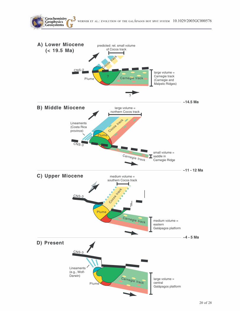
Copyright 2003 by the American Geophysical Union 1 of 28
Werner, R., K. Hoernle, U. Barkckhausen, and F. Hauff, Geodynamic evolution of the Galapagos hot spot system (Central
East Pacific) over the past 20 m.y.: Constraints from morphology, geochemistry, and magnetic anomalies, Geochem. Geophys.
Geosyst., 4(12), 1108, doi:10.1029/2003GC000576, 2003.
1. Introduction
[2] The Galapagos Archipelago is located in the
Central East Pacific Ocean about 1000 km west of
Ecuador and just south of the Cocos-Nazca spread-
ing center (CNS; also known as Galapagos Spread-
ing Center), which represents the boundary where
the Cocos and Nazca Plates separate (Figure 1).
The archipelago is the surface expression of a hot
spot or long-lived mantle plume whose interplay
with the CNS during the Neogene has resulted in
the formation of two hot spot tracks, the Cocos and
Carnegie Ridges and associated seamounts on the
Cocos and Nazca Plates, respectively [Holden and
Dietz, 1972; Hey, 1977; Lonsdale and Klitgord,
1978; Wilson and Hey, 1995]. The Coiba and
Malpelo Ridges are also believed to be products
of the Galapagos hot spot. The history of the CNS
begins at �23 Ma when migration of a preexisting
fracture zone over the Galapagos hot spot caused
the breakup of the Farallon Plate into the Cocos-
and Nazca Plates [Handschumacher, 1976]. Most
of the tectonic record of the opening of the CNS has
already been subducted beneath Central America
and South America, respectively. The earliest
model of the CNS evolution [Holden and Dietz,
1972] suggested that the aseismic Cocos and
Carnegie Ridges were formed simultaneously
while the CNS was in a stationary position over
the Galapagos hot spot. However, it has become
clear that the CNS has been constantly moving
relative to the hot spot since its opening [Hey,
1977; Lonsdale and Klitgord, 1978; Wilson and
Hey, 1995; Wilson, 1996; Barckhausen et al.,
2001]. Although major advances in the identifi-
cation of magnetic seafloor spreading anomalies
around the Cocos-Nazca Plate boundary have been
made, a precise reconstruction of the plate tectonic
development of the region for times before�10 Ma
is still lacking due to missing information about the
tectonic record.
[3] During R/V Sonne cruise SO 144-3 in 1999,
the first systematic rock sampling of the aseismic
ridges and associated seamounts between Gala-
pagos and Central and South America was con-
ducted (Figure 1). Here we report results of
geochemical (major element and Sr-Nd-Pb-iso-
tope) analyses of the recovered volcanic rocks
and interpretations of magnetic profiles recorded
on this cruise. We show that the morphology
and composition of Galapagos hot spot tracks
probably reflect the relative position of the CNS
to the hot spot and/or variations in plume flux.
In addition, we combine the constraints from the
magnetic record with the geochemical composi-
tions of rock samples and the morphology of the
hot spot tracks (1) to reconstruct the long-term
geochemical zonation of the Galapagos plume
and (2) to fill in the missing history of the hot
spot - spreading axis geometry (plume-ridge
interactions) over the past �20 m.y. Hf isotope
data [Geldmacher et al., 2003] and trace element
geochemistry [Harpp et al., 2003] for the same
samples are being published elsewhere.
2. Morphology of the Galapagos HotSpot Tracks
2.1. Cocos Track
[4] The Galapagos hot spot track on Cocos Plate
(‘‘Cocos track’’) is the largest and most complex
morphologic structure in the eastern Central
Pacific. It comprises 2 major morphological
domains: (A) Cocos Ridge, a highstanding broad
NE-SW trending aseismic ridge and (B) the
seamount domain adjacent to the northwestern
flank of the ridge [von Huene et al., 1995]
(Figure 1).
[5] Cocos Ridge, oriented parallel to the recent
motion of the underlying Cocos Plate, extends
more than 1000 km from the CNS directly north
of the Galapagos Platform to the trench off the
coast of Costa Rica (Figure 1). Seamounts are
scattered across the crest and the flanks of the
GeochemistryGeophysicsGeosystems G3G3
werner et al.: evolution of the galApagos hot spot system 10.1029/2003GC000576
2 of 28
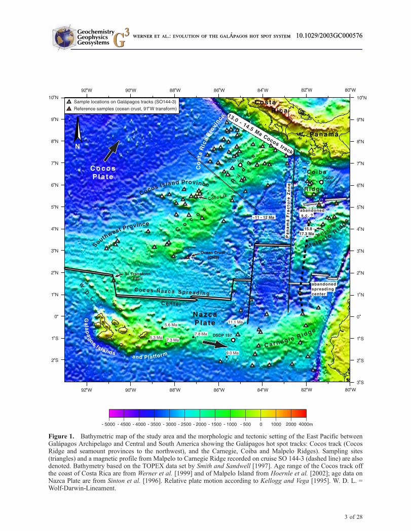
Figure 1. Bathymetric map of the study area and the morphologic and tectonic setting of the East Pacific betweenGalapagos Archipelago and Central and South America showing the Galapagos hot spot tracks: Cocos track (CocosRidge and seamount provinces to the northwest), and the Carnegie, Coiba and Malpelo Ridges). Sampling sites(triangles) and a magnetic profile from Malpelo to Carnegie Ridge recorded on cruise SO 144-3 (dashed line) are alsodenoted. Bathymetry based on the TOPEX data set by Smith and Sandwell [1997]. Age range of the Cocos track offthe coast of Costa Rica are from Werner et al. [1999] and of Malpelo Island from Hoernle et al. [2002]; age data onNazca Plate are from Sinton et al. [1996]. Relative plate motion according to Kellogg and Vega [1995]. W. D. L. =Wolf-Darwin-Lineament.
GeochemistryGeophysicsGeosystems G3G3
werner et al.: evolution of the galApagos hot spot system 10.1029/2003GC000576werner et al.: evolution of the galApagos hot spot system 10.1029/2003GC000576
3 of 28
entire ridge. Off the coast of Costa Rica, the ridge
is up to �300 km broad and rises up about 2000 m
above the adjacent ocean floor to depth of less
than 1000 m. In this region the ridge crest is
marked by steep scarps and an up to 25 km wide,
sediment-filled graben striking sub-parallel to the
ridge axis in its center [e.g., von Huene et al.,
1995]. Off the coast of Panama, the Panama
fracture zone cuts diagonally across the southern
part of Cocos Ridge (Figure 1). Further to the
southwest, the ridge slightly narrows and shallows.
A volume decrease of the ridge toward SW is
evident from seismic profiles across the ridge [e.g.,
Bialas et al., 1999; Walther, 2003; Sallares and
Charvis, 2003].
[6] The seamount domain comprises more than 30
major volcanoes (>1000 m in height) and numer-
ous smaller volcanoes at the northwestern flank of
the Cocos Ridge. The seamounts are not continu-
ously arranged along the ridge flank but can be
subdivided into 3 distinct seamount fields which
differ in number, arrangement and orientation of
the volcanic edifices (Figure 1):
[7] 1. The Costa Rica seamount province, adjacent
to the Pacific coast of Costa Rica, is by far the
largest of the 3 seamount fields comprising 18
major and numerous smaller seamounts. The major
seamounts form two distinct chains which extend
�300 km from the trench to the southwest parallel
to the axis of the Cocos Ridge (Figure 1). A third
NE-SW-trending seamount chain is discernible a
bit further north. Indentations along the Costa Rica
continental rise and earthquake clusters along
extensions of these seamount chains indicate that
parts of these seamount chains have been sub-
ducted beneath Costa Rica [e.g., von Huene et
al., 1995, 2000] and thus were considerably longer
than 300 km.
[8] 2. The Cocos Island seamount province com-
prises Cocos Island and an adjacent group of
seamounts scattered west and southwest of the
island. This seamount field consists of 7 major
and several smaller seamounts. Most of these
seamounts form a acute-angled triangle which
extends from Cocos Island �200 km toward the
west. An approximately east-west trending valley
near Cocos Island (Figure 1) corresponds to the
location of a spreading center abandoned at
�1.8 Ma [Meschede et al., 1998].
[9] 3. The southwest seamount province, located
west of the southwestern end of Cocos Ridge,
consists of a group of 5 large seamounts at ca.
3�200N and 91�W, a single major seamount at
3�500N and 89�150W, and a few small seamounts.
These seamounts are spread over a large area
characterized by normal ocean floor.
[10] Coiba Ridge is a broad north-south trending
structure approximately 150 km long by 100 km
wide. Multibeam echo sounding data obtained
during SO 144-3 cruise proved that satellite
altimetry-derived bathymetric maps are inaccurate
over much of the ridge. In particular, large
seamounts shown rising from the central, south-
eastern and eastern parts of the ridge do not
exist, and the topography in those areas has
minimal relief. Instead, Coiba Ridge appears to
be a large, sediment-covered plateau with steep
western and southern flanks up to 1500 m high
and a gently dipping eastern slope. The western
flank of the ridge is subparallel to the Panama
fracture zone.
2.2. Carnegie Track
[11] Carnegie Ridge is a highstanding, broad, east-
west-trending ridge approximately 600 km long
and up to 300 km wide. This ridge, oriented
approximately parallel to the recent motion of the
underlying Nazca Plate, represents the continuation
of the Galapagos Platform to the east and extends
to the Colombian trench off the coast of Ecuador
(Figure 1). Bathymetry and seismic profiles [e.g.,
Sallares and Charvis, 2003, and references therein]
clearly indicate that height, width and volume of
the Carnegie Ridge increases significantly to the
east. Many seamounts rise from the ridge. Most of
them do not exceed several hundred meters in
height, are relatively smooth with gentle slopes,
and are covered by sediments. Single large sea-
mounts are scattered on and close to the flanks of
the ridge. Five large seamounts on the southern
flanks between �86� and �82�W appear to be
aligned in an east-west direction. Large seamount
GeochemistryGeophysicsGeosystems G3G3
werner et al.: evolution of the galApagos hot spot system 10.1029/2003GC000576
4 of 28
clusters as observed on the Cocos track do not
occur on the Carnegie Ridge.
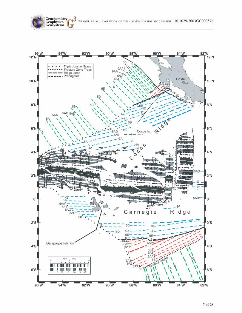
[12] Malpelo Ridge is an elongated, NE-SW trend-
ing aseismic block approximately 300 km long by
100 km wide. The block is bisected by a central
graben that divides a narrow, steep-sided northwest
ridge from a more extensive southeast plateau
[Lonsdale and Fornari, 1980].
3. Background
3.1. Galapagos Islands and HotSpot Tracks
[13] The main islands of the Galapagos Archipel-
ago are located on a shallow submarine platform.
Isolated volcanic islands and seamounts are located
north of the platform (‘‘Wolf-Darwin triangle’’
bounded by the Wolf-Darwin lineament [WDL]
in the west, the CNS in the north and the 91�Wtransform fault in the east [Figure 1]). They are
aligned in three sub-parallel, curved SE-NW trend-
ing seamount lineaments that radiate from the
region around Pinta Island, intersecting the CNS
at their northwestern ends [Christie et al., 2001;
Harpp and Geist, 2002]. The Galapagos Islands
display a complex geochemical zonation. Enriched
plume material forms a horseshoe-shaped region
with depleted material, similar in composition to
mid ocean ridge basalt, in its inner part [e.g., White
and Hofmann, 1978; Geist et al., 1988; White et
al., 1993]. The enriched horseshoe-shaped region
can be subdivided into three distinct geochemical
domains (Northern, Central, and Southern Galapa-
gos Domains, typified by the islands of Pinta,
Fernandina, and Floreana, respectively; Hoernle
et al., 2000). The Northern, Central, Southern,
and Eastern Domains contain the ‘‘WD’’ (Wolf-
Darwin), ‘‘PLUME’’, ‘‘FLO’’ (Floreana), and
‘‘DUM’’ (Depleted Upper Mantle) end-member
compositions, respectively, as defined by Harpp
and White [2000].
[14] Besides for a profile across the Cocos track off
the coast of Costa Rica, only a few samples from
the Cocos, Carnegie, Coiba, and Malpelo Ridges
had been obtained by dredging or drilling previ-
ously. They comprise mainly alkali basalts and Fe-
rich tholeiites but only scarce volcanological, pet-
rological, and geochemical data are available [e.g.,
Engel and Chase, 1965; van Andel et al., 1973;
Heezen and Rawson, 1977; Fornari et al.,
1979; Lonsdale and Fornari, 1980; Cann et al.,
1983; Castillo, 1987; Castillo et al., 1988; Becker et
al., 1989;Hauff et al., 2000]. The rocks from Cocos
Island, located on the northwestern flank of Cocos
Ridge approximately halfway between the CNS and
the Central America (Figure 1), show ocean-island-
basalt (OIB)-type compositions similar to those of
the enriched Galapagos domains but K/Ar and
paleomagnetic dates indicate that the island is only
2 m.y. old [Dalrymple and Cox, 1968; Bellon et al.,
1983; Castillo, 1987; Castillo et al., 1988]. Castillo
[1987] concludes that this late-stage volcanism
on Cocos Ridge was apparently caused by anoma-
lously slow cooling of the lithosphere under the
ridge whereas Meschede et al. [1998] postulate a
second hot spot near Cocos Island.
[15] Ar-Ar age dating and morphological and geo-
chemical studies of the profile across the Cocos
track (Cocos Ridge and seamounts to the NW) off
the coast of Costa Rica (Figure 1) demonstrated
that the oldest (preserved) part of the Cocos track
forms a now-drowned 13.0–14.5 m.y. old paleo-
Galapagos Archipelago [Werner et al., 1999;
Hoernle et al., 2000]. Volcanological studies of
samples from the R/V Sonne 144-3 cruise show
that islands existed continuously above the Gala-
pagos hot spot over at least the last 17 m.y. [Werner
and Hoernle, 2003]. The morphology and geo-
chemical zonation of the 13.0–14.5 Ma paleo-
archipelago into northern, central and southern
plume domains are similar to those of the recent
archipelago. The remarkable similarity in the com-
position and geographical distribution of the geo-
chemical Galapagos Domains at the present hot
spot and the Cocos track profile is intriguing and
may suggest chemical zonation of the Galapagos
plume for at least 14 m.y. [Hoernle et al., 2000].
The crust underlying the paleo-Galapagos Archi-
pelago ranges from 15 Ma in the south to 19 Ma in
the north at the Fisher Ridge [Barckhausen et al.,
2001], as deduced from the magnetic anomalies.
The Fisher Ridge, interpreted to represent a piece
of uplifted ocean crust formed at the CNS, pro-
GeochemistryGeophysicsGeosystems G3G3
werner et al.: evolution of the galApagos hot spot system 10.1029/2003GC000576
5 of 28
duced an age of 19.2 Ma [Werner et al., 1999] in
good agreement with the magnetic data.
[16] The Coiba Ridge is believed to be an exten-
sion of the Cocos track offset by a transform fault,
a predecessor of the Panama fracture zone [e.g.,
Hoernle et al., 2002]. The age of sediments over-
lying the Coiba Ridge have been dated paleonto-
logically at 15 Ma, giving a minimum age for the
Coiba Ridge [van Andel et al., 1973]. Recent40Ar/39Ar age results from Malpelo Island on the
Malpelo Ridge (Figure 1) on the Nazca Plate south
of Coiba Ridge yielded ages of 15.8–17.3 Ma,
giving a minimum age for the underlying Malpelo
Ridge of 17.3 Ma [Hoernle et al., 2002]. The
oldest parts of Carnegie Ridge off the coast of
Ecuador are estimated to have formed �20 m.y.
ago [e.g., White et al., 1993; Meschede and
Barckhausen, 2001].
3.2. Plate Tectonic Evolution andHot Spot - Spreading Axis Geometry
[17] Seafloor-spreading anomalies are reliably iden-
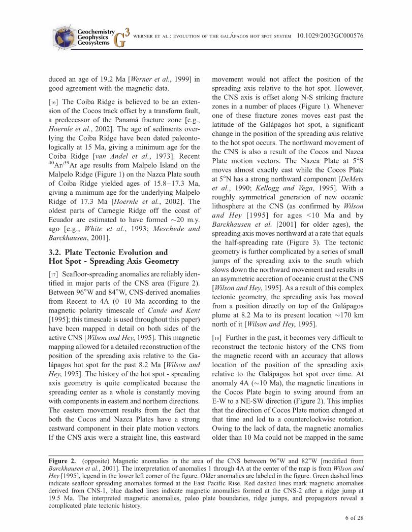
tified in major parts of the CNS area (Figure 2).
Between 96�W and 84�W, CNS-derived anomalies
from Recent to 4A (0–10 Ma according to the
magnetic polarity timescale of Cande and Kent
[1995]; this timescale is used throughout this paper)
have been mapped in detail on both sides of the
active CNS [Wilson and Hey, 1995]. This magnetic
mapping allowed for a detailed reconstruction of the
position of the spreading axis relative to the Ga-
lapagos hot spot for the past 8.2 Ma [Wilson and
Hey, 1995]. The history of the hot spot - spreading
axis geometry is quite complicated because the
spreading center as a whole is constantly moving
with components in eastern and northern directions.
The eastern movement results from the fact that
both the Cocos and Nazca Plates have a strong
eastward component in their plate motion vectors.
If the CNS axis were a straight line, this eastward
movement would not affect the position of the
spreading axis relative to the hot spot. However,
the CNS axis is offset along N-S striking fracture
zones in a number of places (Figure 1). Whenever
one of these fracture zones moves east past the
latitude of the Galapagos hot spot, a significant
change in the position of the spreading axis relative
to the hot spot occurs. The northward movement of
the CNS is also a result of the Cocos and Nazca
Plate motion vectors. The Nazca Plate at 5�Smoves almost exactly east while the Cocos Plate
at 5�N has a strong northward component [DeMets
et al., 1990; Kellogg and Vega, 1995]. With a
roughly symmetrical generation of new oceanic
lithosphere at the CNS (as confirmed by Wilson
and Hey [1995] for ages <10 Ma and by
Barckhausen et al. [2001] for older ages), the
spreading axis moves northward at a rate that equals
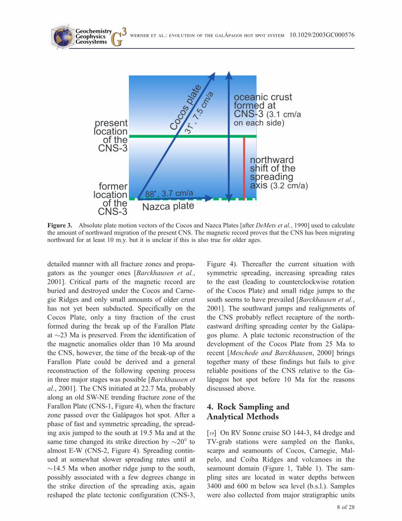
the half-spreading rate (Figure 3). The tectonic
geometry is further complicated by a series of small
jumps of the spreading axis to the south which
slows down the northward movement and results in
an asymmetric accretion of oceanic crust at the CNS
[Wilson and Hey, 1995]. As a result of this complex
tectonic geometry, the spreading axis has moved
from a position directly on top of the Galapagos
plume at 8.2 Ma to its present location �170 km
north of it [Wilson and Hey, 1995].
[18] Further in the past, it becomes very difficult to
reconstruct the tectonic history of the CNS from
the magnetic record with an accuracy that allows
location of the position of the spreading axis
relative to the Galapagos hot spot over time. At
anomaly 4A (�10 Ma), the magnetic lineations in
the Cocos Plate begin to swing around from an
E-W to a NE-SW direction (Figure 2). This implies
that the direction of Cocos Plate motion changed at
that time and led to a counterclockwise rotation.
Owing to the lack of data, the magnetic anomalies
older than 10 Ma could not be mapped in the same
Figure 2. (opposite) Magnetic anomalies in the area of the CNS between 96�W and 82�W [modified fromBarckhausen et al., 2001]. The interpretation of anomalies 1 through 4A at the center of the map is from Wilson andHey [1995], legend in the lower left corner of the figure. Older anomalies are labeled in the figure. Green dashed linesindicate seafloor spreading anomalies formed at the East Pacific Rise. Red dashed lines mark magnetic anomaliesderived from CNS-1, blue dashed lines indicate magnetic anomalies formed at the CNS-2 after a ridge jump at19.5 Ma. The interpreted magnetic anomalies, paleo plate boundaries, ridge jumps, and propagators reveal acomplicated plate tectonic history.
GeochemistryGeophysicsGeosystems G3G3
werner et al.: evolution of the galApagos hot spot system 10.1029/2003GC000576
6 of 28
GeochemistryGeophysicsGeosystems G3G3
werner et al.: evolution of the galApagos hot spot system 10.1029/2003GC000576
7 of 28
detailed manner with all fracture zones and propa-
gators as the younger ones [Barckhausen et al.,
2001]. Critical parts of the magnetic record are
buried and destroyed under the Cocos and Carne-
gie Ridges and only small amounts of older crust
has not yet been subducted. Specifically on the
Cocos Plate, only a tiny fraction of the crust
formed during the break up of the Farallon Plate
at �23 Ma is preserved. From the identification of
the magnetic anomalies older than 10 Ma around
the CNS, however, the time of the break-up of the
Farallon Plate could be derived and a general
reconstruction of the following opening process
in three major stages was possible [Barckhausen et
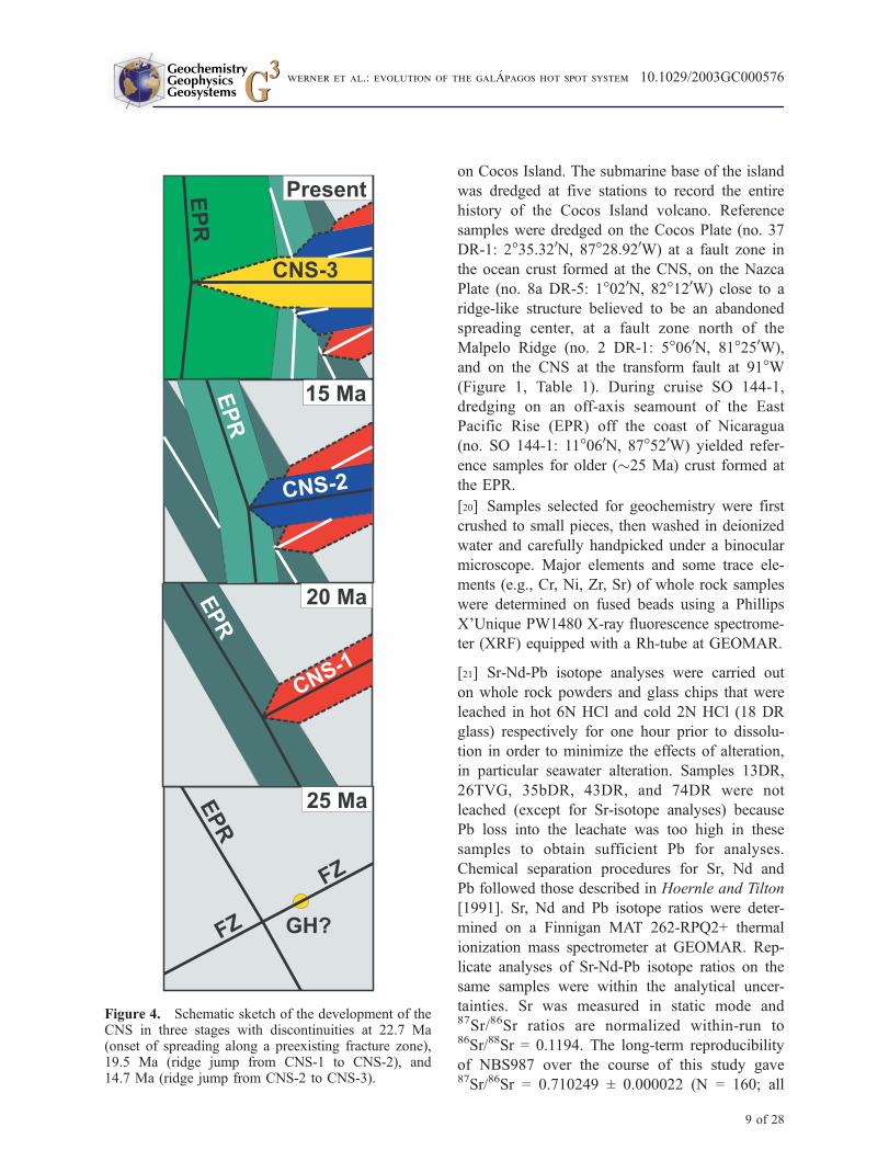
al., 2001]. The CNS initiated at 22.7 Ma, probably
along an old SW-NE trending fracture zone of the
Farallon Plate (CNS-1, Figure 4), when the fracture
zone passed over the Galapagos hot spot. After a
phase of fast and symmetric spreading, the spread-
ing axis jumped to the south at 19.5 Ma and at the
same time changed its strike direction by �20� toalmost E-W (CNS-2, Figure 4). Spreading contin-
ued at somewhat slower spreading rates until at
�14.5 Ma when another ridge jump to the south,
possibly associated with a few degrees change in
the strike direction of the spreading axis, again
reshaped the plate tectonic configuration (CNS-3,
Figure 4). Thereafter the current situation with
symmetric spreading, increasing spreading rates
to the east (leading to counterclockwise rotation
of the Cocos Plate) and small ridge jumps to the
south seems to have prevailed [Barckhausen et al.,
2001]. The southward jumps and realignments of
the CNS probably reflect recapture of the north-
eastward drifting spreading center by the Galapa-
gos plume. A plate tectonic reconstruction of the
development of the Cocos Plate from 25 Ma to
recent [Meschede and Barckhausen, 2000] brings
together many of these findings but fails to give
reliable positions of the CNS relative to the Ga-
lapagos hot spot before 10 Ma for the reasons
discussed above.
4. Rock Sampling andAnalytical Methods
[19] On RV Sonne cruise SO 144-3, 84 dredge and
TV-grab stations were sampled on the flanks,
scarps and seamounts of Cocos, Carnegie, Mal-
pelo, and Coiba Ridges and volcanoes in the
seamount domain (Figure 1, Table 1). The sam-
pling sites are located in water depths between
3400 and 600 m below sea level (b.s.l.). Samples
were also collected from major stratigraphic units
Figure 3. Absolute plate motion vectors of the Cocos and Nazca Plates [after DeMets et al., 1990] used to calculatethe amount of northward migration of the present CNS. The magnetic record proves that the CNS has been migratingnorthward for at least 10 m.y. but it is unclear if this is also true for older ages.
GeochemistryGeophysicsGeosystems G3G3
werner et al.: evolution of the galApagos hot spot system 10.1029/2003GC000576
8 of 28
on Cocos Island. The submarine base of the island
was dredged at five stations to record the entire
history of the Cocos Island volcano. Reference
samples were dredged on the Cocos Plate (no. 37
DR-1: 2�35.320N, 87�28.920W) at a fault zone in
the ocean crust formed at the CNS, on the Nazca
Plate (no. 8a DR-5: 1�020N, 82�120W) close to a
ridge-like structure believed to be an abandoned
spreading center, at a fault zone north of the
Malpelo Ridge (no. 2 DR-1: 5�060N, 81�250W),
and on the CNS at the transform fault at 91�W(Figure 1, Table 1). During cruise SO 144-1,
dredging on an off-axis seamount of the East
Pacific Rise (EPR) off the coast of Nicaragua
(no. SO 144-1: 11�060N, 87�520W) yielded refer-
ence samples for older (�25 Ma) crust formed at
the EPR.
[20] Samples selected for geochemistry were first
crushed to small pieces, then washed in deionized
water and carefully handpicked under a binocular
microscope. Major elements and some trace ele-
ments (e.g., Cr, Ni, Zr, Sr) of whole rock samples
were determined on fused beads using a Phillips
X’Unique PW1480 X-ray fluorescence spectrome-
ter (XRF) equipped with a Rh-tube at GEOMAR.
[21] Sr-Nd-Pb isotope analyses were carried out
on whole rock powders and glass chips that were
leached in hot 6N HCl and cold 2N HCl (18 DR
glass) respectively for one hour prior to dissolu-
tion in order to minimize the effects of alteration,
in particular seawater alteration. Samples 13DR,
26TVG, 35bDR, 43DR, and 74DR were not
leached (except for Sr-isotope analyses) because
Pb loss into the leachate was too high in these
samples to obtain sufficient Pb for analyses.
Chemical separation procedures for Sr, Nd and
Pb followed those described in Hoernle and Tilton
[1991]. Sr, Nd and Pb isotope ratios were deter-
mined on a Finnigan MAT 262-RPQ2+ thermal
ionization mass spectrometer at GEOMAR. Rep-
licate analyses of Sr-Nd-Pb isotope ratios on the
same samples were within the analytical uncer-
tainties. Sr was measured in static mode and87Sr/86Sr ratios are normalized within-run to86Sr/88Sr = 0.1194. The long-term reproducibility
of NBS987 over the course of this study gave87Sr/86Sr = 0.710249 ± 0.000022 (N = 160; all
Figure 4. Schematic sketch of the development of theCNS in three stages with discontinuities at 22.7 Ma(onset of spreading along a preexisting fracture zone),19.5 Ma (ridge jump from CNS-1 to CNS-2), and14.7 Ma (ridge jump from CNS-2 to CNS-3).
GeochemistryGeophysicsGeosystems G3G3
werner et al.: evolution of the galApagos hot spot system 10.1029/2003GC000576
9 of 28

reported errors are ±2sigma). The 143Nd/144Nd
ratios are normalized within-run to 146Nd/144Nd =
0.7219 and measured in multi dynamic mode. The
La Jolla standard yields a long-term average for143Nd/144Nd of 0.511841 ± 0.000011 (N = 73). Our
inhouse Nd standard Spex gives 143Nd/144Nd =
0.511709 ± 0.000013 (N = 134) over the same
period. All Pb isotope analyses were corrected for
fractionation using the NBS981 values of Todt et
al. [1996].
5. Results
5.1. Composition of the Rock Samples
[22] The Cocos, Carnegie, Coiba and Malpelo
Ridges and associated seamounts yielded a broad
Table 1. Sample Locations
Sample ID Location Latitude Longitude Water Depth (on Bottom)
Seamounts48 DR-1 Costa Rica seamount province 06�47.740N 085�22.880W 1517 m60 DR-2 Costa Rica seamount province 07�23.200N 085�11.180W 1723 m74 DR-1 Costa Rica seamount province 07�23.020N 086�31.290W 2210 m78 DR-1 Costa Rica seamount province 08�06.880N 085�47.500W 1465 m69 DR-1 Cocos Island seamount prov. 05�12.520N 087�56.770W 2077 m71 DR-1 Cocos Island seamount prov. 05�30.960N 088�34.790W 1251 m42 DR-1 Cocos Island seamount prov. 05�08.680N 087�32.600W 2050 mCocos 11 Cocos Island (Wafer Valley)Cocos 17 Cocos Island (Bahia Chatham)Cocos 27 Cocos Island (Bahia Chatham)Cocos 34 Cocos Island (Bahia Wafer)Cocos 36 Cocos Island (Bahia Wafer)Cocos 37 Cocos Island (Bahia Wafer)Cocos 39 Cocos Island (Bahia Wafer)Cocos 42 Cocos Island (Top of Cerro Iglesias)64 DR-1 Cocos Island (submarine base) 05�45.660N 086�54.080W 1802 m30 DR-1 Southwest seamount province 03�08.510N 091�06.000W 2436 m33 DR-1 Southwest seamount province 03�53.880N 089�13.620W 1694 m
Ridges3 TVG-4 Malpelo Ridge 04�28.020N 080�54.340W 916 m5 DR-1 Malpelo Ridge 04�33.940N 080�41.980W 1639 m6 DR-4 Malpelo Ridge 04�09.320N 081�16.510W 1564 m7 DR-1 Malpelo Ridge 04�19.920N 081�52.480W 3000 m11a DR-1 Carnegie Ridge 00�03.330N 082�07.340W 1446 m12 DR-1 Carnegie Ridge 00�23.890N 081�27.180W 2364 m13 DR-1 Carnegie Ridge 00�26.200S 081�59.510W 1250 m17 TVG-1 Carnegie Ridge 02�09.830S 082�36.640W 1899 m18 DR-1 Carnegie Ridge 02�13.550S 083�40.940W 2449 m26 TVG-1 Carnegie Ridge 00�18.010N 084�58.540W 1388 m28 DR-1 Carnegie Ridge 02�04.260S 085�55.000W 2495 m35b DR-1 S-Cocos Ridge 03�22.650N 088�18.370W 1710 m38 DR-12 S-Cocos Ridge 04�21.590N 085�47.050W 2419 m43 DR-1 N-Cocos Ridge 05�18.600N 085�22.670W 2066 m44 DR-14 N-Cocos Ridge 05�58.100N 083�40.030W 2961 m49a DR-1 N-Cocos Ridge 06�56.390N 084�14.950W 1615 m53 DR-1 N-Cocos Ridge 07�36.240N 083�25.210W 1530 m88 DR-1 Coiba Ridge 06�12.270N 081�56.930W 1848 m90 DR-8 Coiba Ridge 05�35.550N 081�35.070W 1571 m
Reference Samples2 DR-1 CNS-crust 05�06.330N 081�25.020W 3354 m8a DR-5 CNS-crust 01�01.560N 082�11.400W 3375 m37 DR-1 CNS-crust 02�35.320N 087�28.920W 3328 m29a DR-5 91� transform (CNS) 01�35.200N 090�47.310W 2428 mSO 144-1 Nicaragua-seamount 11�05.930N 087�51.730W 3300 m
GeochemistryGeophysicsGeosystems G3G3
werner et al.: evolution of the galApagos hot spot system 10.1029/2003GC000576
10 of 28
spectrum of rock types including lava (e.g., pillow
and sheet lava fragments), subvolcanic and plutonic
rocks (e.g., gabbro), peridotite, volcaniclastic rocks
(e.g., hyaloclastite, scoria, pumice) and sedimen-
tary rocks (e.g., clay-, silt- and limestone, con-
glomerate, turbidite). The samples vary from fresh
to deeply weathered. The most common alteration
products are palagonite, iddingsite, chlorite, and
iron oxides. Hydrothermal alteration involving
silicification, development of clay minerals, and
occasional development of pyrite ± pyrrhotite has
affected some samples, in particular many of the
gabbroic rocks.
[23] Petrographically, olivine-, olivine-pyroxene-
and plagioclase-bearing lavas dominate. Gabbro
occurs in a 100 km-wide band along the SE margin
of the Cocos Ridge at the Panama fracture zone
suggesting that cross-sections through the ridge
have been exposed, most likely by movement
along the Panama fracture zone.
[24] Analyzed samples from the ridges and sea-
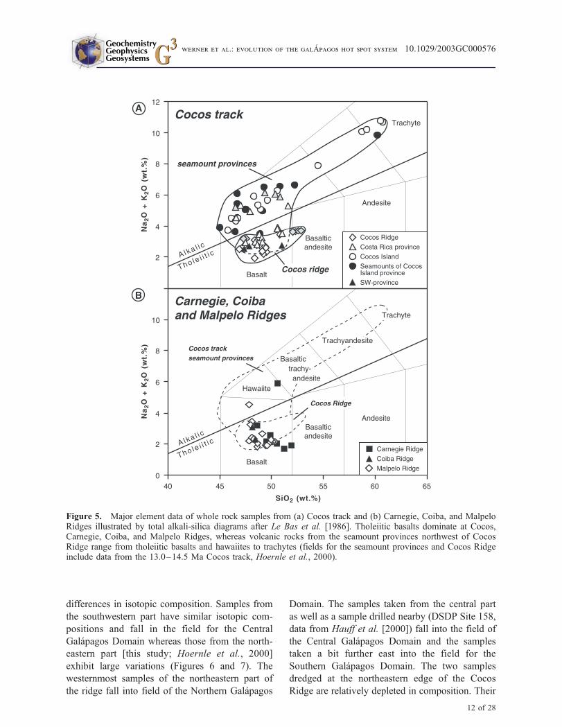
mounts range from basalt to trachytes with SiO2 =
45–61 wt.% and MgO = 1.0–10.3 wt.%. There is a
general difference in chemical composition be-
tween the seamount provinces and the ridge along
the Cocos track (Figure 5). Samples from the Cocos
Ridge are exclusively tholeiitic. The volcanic rocks
from the seamounts range from tholeiitic to alkalic
compositions, but most of them are alkalic. Lavas
from the southwest province are tholeiitic basalts
and basaltic andesites, whereas those from the
seamounts off the coast of Costa Rica extend to
higher contents of alkalies (Na2O and K2O) at
similar SiO2 and range from basalts to hawaiites.
The volcanic rocks from the Cocos Island sea-
mount province generally have alkalic composi-
tions and range from alkali basalts and hawaiites to
trachytes (Figure 5a). The samples from the Carne-
gie, Coiba, and Malpelo Ridges are generally
tholeiitic and fall in a narrow field ranging from
basalts to basaltic andesites (Figure 5b).
5.2. Sr-Nd-Pb-Isotope Geochemistry
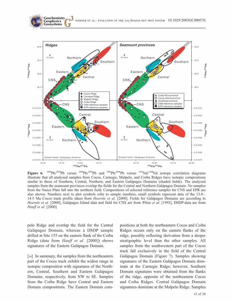
[25] The Sr-Nd-Pb isotope data are presented in
Tables 2a and 2b. With one exception (sample no.
28 DR-1 from Carnegie Ridge), all analyzed sam-
ples from the Galapagos hot spot tracks have
higher Sr and Pb and lower Nd isotopic composi-
tions compared to MORB from the CNS or EPR
and plot closely to the four geochemical domains
defined by the Sr-Nd-Pb isotopic composition of
the present Galapagos Archipelago [hereafter
referred to as Northern, Central, Southern, and
Eastern Galapagos Domains as defined by Hoernle
et al., 2000] (Figure 6). It should be noted that the
term domains simply refer to geographic regions in
the Galapagos Archipelago in which the volcanic
rocks have distinct isotopic compositions. The
sample taken from the 91�W transform fault (no.
29a DR-5) at the CNS directly north of the Ga-
lapagos Islands has isotopically enriched signatures
with Sr and Pb being more radiogenic and Nd
being less radiogenic than CNS and EPR-MORB
samples (samples no. 2, 8a, 37, and from the
seamount off the coast of Nicaragua; Figure 6).
The occurrence of geochemically enriched material
at the 91� transform fault may suggest northward
flow of Galapagos plume material to this area of
the spreading center.
[26] The rocks analyzed from volcanoes of the
seamount provinces have isotopic compositions
that overlap with those of the Northern and Central
Galapagos Domains (Figures 6 and 7). All samples
from the Costa Rica seamount province [this
study; Hoernle et al., 2000] plot within or on an
extension of the field of the Northern Galapagos
Domain. The samples from the southwest sea-
mount province and the Cocos Island seamount
province fall within the relatively narrow field for
the Central Galapagos Domain. The rocks from
Cocos Island and its submarine base show very
little variation in isotopic composition with87Sr/86Sr = 0.70297 � 0.70306, 143Nd/144Nd =
0.51296 � 0.51299, 206Pb/204Pb = 19.12 � 19.29,207Pb/204Pb = 15.57 � 15.59, and 208Pb/204Pb =
38.83 � 38.97, similar to the previously published
Sr-Nd-Pb isotopic data from Cocos Island
[Castillo, 1987; Castillo et al., 1988].
[27] The samples analyzed from the Cocos Ridge
show a wide range in isotopic composition over-
lapping all four geochemical Galapagos Domains
(Figures 6 and 7). The northeastern and south-
western parts of the Cocos Ridge show significant
GeochemistryGeophysicsGeosystems G3G3
werner et al.: evolution of the galApagos hot spot system 10.1029/2003GC000576
11 of 28
differences in isotopic composition. Samples from
the southwestern part have similar isotopic com-
positions and fall in the field for the Central
Galapagos Domain whereas those from the north-
eastern part [this study; Hoernle et al., 2000]
exhibit large variations (Figures 6 and 7). The
westernmost samples of the northeastern part of
the ridge fall into field of the Northern Galapagos
Domain. The samples taken from the central part
as well as a sample drilled nearby (DSDP Site 158,
data from Hauff et al. [2000]) fall into the field of
the Central Galapagos Domain and the samples
taken a bit further east into the field for the
Southern Galapagos Domain. The two samples
dredged at the northeastern edge of the Cocos
Ridge are relatively depleted in composition. Their
Figure 5. Major element data of whole rock samples from (a) Cocos track and (b) Carnegie, Coiba, and MalpeloRidges illustrated by total alkali-silica diagrams after Le Bas et al. [1986]. Tholeiitic basalts dominate at Cocos,Carnegie, Coiba, and Malpelo Ridges, whereas volcanic rocks from the seamount provinces northwest of CocosRidge range from tholeiitic basalts and hawaiites to trachytes (fields for the seamount provinces and Cocos Ridgeinclude data from the 13.0–14.5 Ma Cocos track, Hoernle et al., 2000).
GeochemistryGeophysicsGeosystems G3G3
werner et al.: evolution of the galApagos hot spot system 10.1029/2003GC000576
12 of 28
slightly more enriched composition compared to
CNS and MORB and the occurrence of vesicular
lavas and beach cobbles at these sites indicate
shallow to subaerial eruption at a (paleo-) Galapa-
gos Archipelago. Therefore we attribute these
samples to the Eastern Galapagos Domain rather
than to ocean crust formed at the CNS. The
presence of Eastern Domain signatures exclusively
on the southeastern flank of the Cocos Ridge
suggests that it may reflect the composition of
deeper portions of the ridge.
[28] The samples from Carnegie and Malpelo
Ridges have isotopic compositions similar to those
of the Southern, Central and Eastern Galapagos
Domains; none fall into the Northern Domain.
Three samples from the Carnegie Ridge are
enriched and fall into the field for the Southern
Galapagos Domain (Figures 6 and 7), whereas 4
samples have depleted compositions. Three of the
depleted samples, as well as a DSDP sample drilled
at Site 157 (data from Hauff et al. [2000]), are
slightly enriched compared to CNS and MORB.
The high vesicularity of the dredged rocks and the
occurrence of conglomerates at station 13 suggest
shallow water to subaerial eruptions at volcanic
islands. Therefore we attribute these samples to the
Eastern Galapagos Domain rather than to the ocean
crust. Sample 28 DR-1, however, is a pillow
fragment with small vesicles and falls into the field
for CNS and MORB. It has been dredged from a
seamount at the southern edge of Carnegie Ridge
and it remains unclear whether it has been formed
at the CNS or the Galapagos hot spot. The three
samples plotting within the Southern Domain were
dredged from the flanks of the Carnegie Ridge and
thus may be derived from deeper levels of the ridge
than the Eastern Domain samples from the top of
the ridge, opposite of what was observed at the
northeastern Cocos Ridge. Three of four analyzed
samples from Malpelo Ridge have similar isotopic
compositions and fall into the field for the Central
Galapagos Domain. The remaining sample shows
slightly more radiogenic Pb-isotope ratios and plots
on the boundary with the Southern Galapagos
Domain (Figures 6 and 7).
[29] The analyzed samples from Coiba Ridge have
similar isotopic compositions to those from Mal-Table
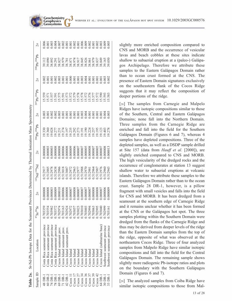
2a.
Sr-Nd-PbIsotopeDatafortheSeamountProvincesDetermined
byThermal
IonizationMassSpectrometry
Sam
ple
IDLocation
87Sr/86Sr
2s
143Nd/144Nd
2s
206Pb/204Pb
2s
207Pb/204Pb
2s
208Pb/204Pb
2s
48DR-1
CostaRicaseam
ountprovince
0.703359
0.000008
0.512917
0.000008
19.330
0.003
15.559
0.002
39.112
0.006
60DR-2
CostaRicaseam
ountprovince
0.703554
0.000008
0.512885
0.000003
19.360
0.001
15.571
0.001
39.090
0.001
74DR-1
CostaRicaseam
ountprovince
0.703982
0.000003
0.512978
0.000003
19.028
0.002
15.557
0.001
38.892
0.003
78DR-1
CostaRicaseam
ountprovince
0.703572
0.000009
0.512838
0.000008
19.277
0.002
15.591
0.002
39.291
0.004
69DR-1
CocosIslandseam
ountprov.
0.702974
0.000010
0.512986
0.000008
19.231
0.003
15.575
0.003
38.827
0.007
71DR-1
CocosIslandseam
ountprov.
0.703163
0.000006
0.513018
0.000006
19.274
0.001
15.591
0.001
38.979
0.002
42DR-1
CocosIslandseam
ountprov.
0.702924
0.000008
0.513007
0.000008
19.197
0.001
15.573
0.001
38.781
0.001
Cocos11
CocosIsland
0.702972
0.000007
0.512972
0.000009
19.235
0.001
15.572
0.000
38.871
0.001
Cocos17
CocosIsland
0.703057
0.000008
0.512963
0.000006
19.292
0.001
15.579
0.001
38.974
0.002
Cocos27
CocosIsland
0.703023
0.000007
0.512977
0.000007
19.273
0.001
15.578
0.001
38.917
0.001
Cocos34
CocosIsland
0.703010
0.000007
0.512988
0.000007
19.191
0.003
15.578
0.003
38.845
0.006
Cocos36
CocosIsland
0.703003
0.000007
0.512970
0.000005
19.190
0.004
15.572
0.004
38.826
0.009
Cocos37
CocosIsland
0.702994
0.000007
0.512981
0.000008
19.224
0.001
15.576
0.001
38.861
0.002
Cocos39
CocosIsland
0.703063
0.000008
0.512964
0.000007
19.257
0.001
15.577
0.001
38.979
0.001
Cocos42
CocosIsland
0.702995
0.000008
0.512987
0.000005
19.195
0.001
15.572
0.001
38.837
0.002
64DR-1
CocosIsland(submarinebase)
0.703040
0.000007
0.512976
0.000007
19.123
0.001
15.590
0.001
38.849
0.003
30DR-1
Southwestseam
ountprovince
0.702999
0.000006
0.512960
0.000008
19.403
0.004
15.593
0.003
39.165
0.009
33DR-1
Southwestseam
ountprovince
0.703161
0.000009
0.512943
0.000013
19.278
0.003
15.583
0.002
39.050
0.005
GeochemistryGeophysicsGeosystems G3G3
werner et al.: evolution of the galApagos hot spot system 10.1029/2003GC000576
13 of 28
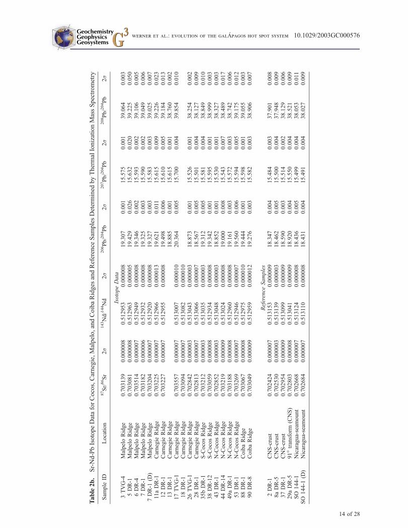
Table2b.
Sr-Nd-PbIsotopeDataforCocos,Carnegie,Malpelo,andCoibaRidges
andReference
Sam
plesDetermined
byThermalIonizationMassSpectrometry
Sam
ple
IDLocation
87Sr/86Sr
2s
143Nd/144Nd
2s
206Pb/204Pb
2s
207Pb/204Pb
2s
208Pb/204Pb
2s
IsotopeData
3TVG-4
MalpeloRidge
0.703139
0.000008
0.512953
0.000008
19.307
0.001
15.575
0.001
39.064
0.003
5DR-1
MalpeloRidge
0.703081
0.000008
0.512963
0.000005
19.429
0.026
15.632
0.020
39.225
0.050
6DR-4
MalpeloRidge
0.703514
0.000007
0.512949
0.000008
19.346
0.002
15.593
0.002
39.106
0.005
7DR-1
MalpeloRidge
0.703182
0.000006
0.512932
0.000008
19.325
0.003
15.590
0.002
39.049
0.006
7DR-1
(D)
MalpeloRidge
0.703204
0.000007
0.512920
0.000008
19.327
0.003
15.583
0.003
39.025
0.007
11aDR-1
Carnegie
Ridge
0.703225
0.000007
0.512966
0.000013
19.621
0.011
15.615
0.009
39.226
0.023
12DR-1
Carnegie
Ridge
0.703227
0.000007
0.512955
0.000008
19.498
0.006
15.610
0.005
39.184
0.013
13DR-1
Carnegie
Ridge
18.885
0.001
15.615
0.001
38.760
0.002
17TVG-1
Carnegie
Ridge
0.703557
0.000007
0.513007
0.000010
20.364
0.005
15.700
0.004
39.854
0.010
18DR-1
Carnegie
Ridge
0.703094
0.000007
0.513082
0.000010
26TVG-1
Carnegie
Ridge
0.702842
0.000003
0.513043
0.000003
18.873
0.001
15.526
0.001
38.254
0.002
28DR-1
Carnegie
Ridge
0.702813
0.000007
0.513066
0.000007
18.567
0.005
15.501
0.004
38.127
0.009
35bDR-1
S-CocosRidge
0.703212
0.000003
0.513035
0.000003
19.312
0.005
15.581
0.004
38.849
0.010
38DR-12
S-CocosRidge
0.703059
0.000008
0.512934
0.000008
19.342
0.001
15.595
0.001
38.999
0.003
43DR-1
N-CocosRidge
0.702852
0.000003
0.513048
0.000003
18.852
0.001
15.530
0.001
38.327
0.003
44DR-14
N-CocosRidge
0.703219
0.000009
0.513024
0.000008
19.000
0.008
15.543
0.007
38.489
0.017
49aDR-1
N-CocosRidge
0.703188
0.000008
0.512960
0.000008
19.161
0.003
15.572
0.003
38.742
0.006
53DR-1
N-CocosRidge
0.703269
0.000007
0.512946
0.000007
19.560
0.006
15.594
0.005
39.175
0.012
88DR-1
CoibaRidge
0.703067
0.000008
0.512975
0.000010
19.444
0.001
15.598
0.001
39.055
0.003
90DR-8
CoibaRidge
0.703049
0.000009
0.512959
0.000012
19.276
0.003
15.582
0.003
38.906
0.007
Reference
Samples
2DR-1
CNS-crust
0.702424
0.000007
0.513153
0.000009
18.347
0.004
15.484
0.003
37.901
0.008
8aDR-5
CNS-crust
0.702530
0.000003
0.513139
0.000003
18.462
0.005
15.500
0.004
37.948
0.009
37DR-1
CNS-crust
0.702954
0.000009
0.513099
0.000009
18.590
0.003
15.514
0.002
38.129
0.006
29aDR-5
91�transform
(CNS)
0.702803
0.000008
0.513041
0.000009
18.920
0.004
15.550
0.004
38.521
0.009
SO
144-1
Nicaragua-seam
ount
0.702668
0.000007
0.513124
0.000008
18.436
0.005
15.499
0.004
38.053
0.011
SO
144-1
(D)
Nicaragua-seam
ount
0.702684
0.000007
0.513110
0.000008
18.431
0.004
15.491
0.004
38.027
0.009
GeochemistryGeophysicsGeosystems G3G3
werner et al.: evolution of the galApagos hot spot system 10.1029/2003GC000576
14 of 28
pelo Ridge and overlap the field for the Central
Galapagos Domain, whereas a DSDP sample
drilled at Site 155 on the eastern flank of the Coiba
Ridge (data from Hauff et al. [2000]) shows
signatures of the Eastern Galapagos Domain.
[30] In summary, the samples from the northeastern
part of the Cocos track exhibit the widest range in
isotopic composition with signatures of the North-
ern, Central, Southern and Eastern Galapagos
Domains, respectively, from NW to SE. Samples
from the Coiba Ridge have Central and Eastern
Domain compositions. The Eastern Domain com-
positions at both the northeastern Cocos and Coiba
Ridges occurs only on the eastern flanks of the
ridge, possibly reflecting derivation from a deeper
stratigraphic level than the other samples. All
samples from the southwestern part of the Cocos
track fall exclusively in the field of the Central
Galapagos Domain (Figure 7). Samples showing
signatures of the Eastern Galapagos Domain dom-
inate at the Carnegie Ridge; however, Southern
Domain signatures were obtained from the flanks
of the ridge, opposite of the northeastern Cocos
and Coiba Ridges. Central Galapagos Domain
signatures dominate at the Malpelo Ridge. Samples
Figure 6. 206Pb/204Pb versus 208Pb/204Pb and 206Pb/204Pb versus 143Nd/144Nd isotope correlation diagramsillustrate that all analyzed samples from Cocos, Carnegie, Malpelo, and Coiba Ridges have isotopic compositionssimilar to those of Southern, Central, Northern, and Eastern Galapagos Domains (shaded fields). The analyzedsamples from the seamount provinces overlap the fields for the Central and Northern Galapagos Domain. No samplesfrom the Nazca Plate fall into the northern field. Compositions of selected reference samples for CNS and EPR arealso shown. Numbers next to plot symbols refer to sample numbers, small symbols represent data of the 13.0–14.5 Ma Cocos track profile taken from Hoernle et al. [2000]. Fields for Galapagos Domains are according toHoernle et al. [2000], Galapagos Island data and field for CNS are from White et al. [1993], DSDP-data are fromHauff et al. [2000].
GeochemistryGeophysicsGeosystems G3G3
werner et al.: evolution of the galApagos hot spot system 10.1029/2003GC000576
15 of 28

with isotopic compositions similar to the Northern
Domain were not found east of 90�W on Nazca
Plate.
6. Discussion
6.1. Origin of the Malpelo andCoiba Ridges
[31] All samples from the Cocos track and the
Carnegie, Malpelo, and Coiba Ridges have isotopic
compositions similar to volcanic rocks of the Ga-
lapagos Archipelago, indicating an origin of these
structures from the Galapagos hot spot (Figure 6).
While the Cocos and Carnegie Ridges are ‘‘typical’’
hot spot tracks extending from the Galapagos hot
spot in the direction of plate motion, the origin and
evolution of the Coiba and Malpelo Ridges are still
somewhat problematic.
6.1.1. Coiba Ridge
[32] The Coiba Ridge is located south of Panama
in the area where subduction ceased within the
Neogene. The geochemistry of dredged rock
samples and of a DSDP sample [Hauff et al.,
2000] confirms that it also formed as part of a
Galapagos hot spot track. The age of the Coiba
Figure 7. Overview map illustrating the geographic position of the geochemical Galapagos domains (according toHoernle et al. [2000]) and their distribution on aseismic ridges and associated seamounts between the GalapagosIslands and Central and South America. The enriched Northern, Central, and Southern Domains of the presentGalapagos Archipelago occur in the same relative geographic positions along the northeastern part of the Cocos track(small symbols represent data from Hoernle et al. [2000]), whereas the southwestern part of the Cocos track appearsto be homogeneous in isotopic composition with signatures of the Central Galapagos Domain. The change ingeochemical composition along the Cocos track (denoted by the dashed line) correlates with a change in morphologyand can be dated at �11–12 Ma based on magnetic data and plate motion rates. On the Nazca Plate, samples withsignatures of the Southern and Eastern Galapagos Domains dominate at the Carnegie Ridge and those with signaturesof the Central Galapagos Domain at the Malpelo Ridge. Relative plate motion rates and directions for the Cocos Plateare from Kellogg and Vega [1995], Wilson [1996], and Barckhausen et al. [2001]; numbers next to sample locationsrefer to sample numbers.
GeochemistryGeophysicsGeosystems G3G3
werner et al.: evolution of the galApagos hot spot system 10.1029/2003GC000576
16 of 28
Ridge at the DSDP site 155 must be greater than
15 Ma based on the age of the sediment cover
[van Andel et al., 1973]. The crust underlying the
ridge formed during the initial opening of the CNS
as part of the Cocos Plate and is 22.7–21.0 m.y.
old [Barckhausen et al., 2001], placing a maximum
age on the formation of the Coiba Ridge. The
spreading center between the Coiba and Malpelo
Ridges may have been abandoned during the plate
tectonic reorganization at 19.5 Ma (jump from
CNS-1 to CNS-2, Figure 4). We will discuss
further constraints on the age and origin of the
Coiba Ridge below.
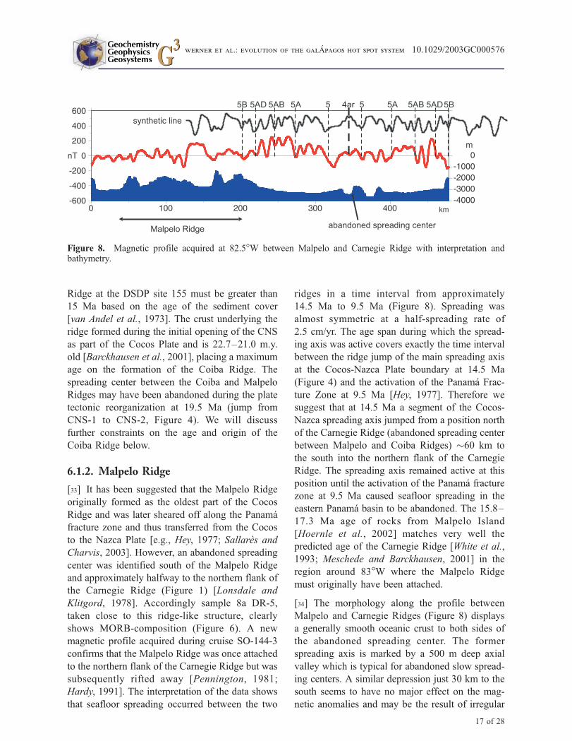
6.1.2. Malpelo Ridge
[33] It has been suggested that the Malpelo Ridge
originally formed as the oldest part of the Cocos
Ridge and was later sheared off along the Panama
fracture zone and thus transferred from the Cocos
to the Nazca Plate [e.g., Hey, 1977; Sallares and
Charvis, 2003]. However, an abandoned spreading
center was identified south of the Malpelo Ridge
and approximately halfway to the northern flank of
the Carnegie Ridge (Figure 1) [Lonsdale and
Klitgord, 1978]. Accordingly sample 8a DR-5,
taken close to this ridge-like structure, clearly
shows MORB-composition (Figure 6). A new
magnetic profile acquired during cruise SO-144-3
confirms that the Malpelo Ridge was once attached
to the northern flank of the Carnegie Ridge but was
subsequently rifted away [Pennington, 1981;
Hardy, 1991]. The interpretation of the data shows
that seafloor spreading occurred between the two
ridges in a time interval from approximately
14.5 Ma to 9.5 Ma (Figure 8). Spreading was
almost symmetric at a half-spreading rate of
2.5 cm/yr. The age span during which the spread-
ing axis was active covers exactly the time interval
between the ridge jump of the main spreading axis
at the Cocos-Nazca Plate boundary at 14.5 Ma
(Figure 4) and the activation of the Panama Frac-
ture Zone at 9.5 Ma [Hey, 1977]. Therefore we
suggest that at 14.5 Ma a segment of the Cocos-
Nazca spreading axis jumped from a position north
of the Carnegie Ridge (abandoned spreading center
between Malpelo and Coiba Ridges) �60 km to
the south into the northern flank of the Carnegie
Ridge. The spreading axis remained active at this
position until the activation of the Panama fracture
zone at 9.5 Ma caused seafloor spreading in the
eastern Panama basin to be abandoned. The 15.8–
17.3 Ma age of rocks from Malpelo Island
[Hoernle et al., 2002] matches very well the
predicted age of the Carnegie Ridge [White et al.,
1993; Meschede and Barckhausen, 2001] in the
region around 83�W where the Malpelo Ridge
must originally have been attached.
[34] The morphology along the profile between
Malpelo and Carnegie Ridges (Figure 8) displays
a generally smooth oceanic crust to both sides of
the abandoned spreading center. The former
spreading axis is marked by a 500 m deep axial
valley which is typical for abandoned slow spread-
ing centers. A similar depression just 30 km to the
south seems to have no major effect on the mag-
netic anomalies and may be the result of irregular
Figure 8. Magnetic profile acquired at 82.5�W between Malpelo and Carnegie Ridge with interpretation andbathymetry.
GeochemistryGeophysicsGeosystems G3G3
werner et al.: evolution of the galApagos hot spot system 10.1029/2003GC000576
17 of 28
spreading processes shortly before the seafloor
spreading was abandoned in this area. Malpelo
Ridge has a rugged morphology and is clearly
bounded against the smooth oceanic crust on its
southern edge (profile km 200 in Figure 8). Close
to the end of the profile, the northern edge of
Carnegie Ridge is marked by a 1000 m high step
which clearly separates the ridge form the smooth
oceanic crust generated at the now abandoned
spreading center and which is interpreted as the
conjugate to the southern edge of Malpelo Ridge.
The identical maximum crustal thickness of the
Malpelo and eastern Carnegie Ridges (19.1 and
19.0 km, respectively [Sallares and Charvis, 2003,
and references therein]) provide additional support
for this reconstruction.
6.2. Chemical Zonation of Hot SpotTracks and Galapagos Plume
[35] One of the most striking features of the present
Galapagos Archipelago is the spatial variation in
chemical composition of the Galapagos lavas [e.g.,
White and Hofmann, 1978; Geist et al., 1988;
Vicenzi et al., 1990; White et al., 1993; Hoernle
et al., 2000; Harpp and White, 2001]. White et al.
[1993] propose thermal entrainment of depleted
asthenosphere by an enriched mantle plume bent
by velocity shear in direction of the plate move-
ment in the uppermost asthenosphere to explain the
presence of depleted lavas within a horseshoe of
more enriched material. This model predicts hot
spot tracks on the Cocos and Nazca Plates with
stripes of enriched Galapagos material bounding a
depleted central stripe. Volcanic rocks with
enriched compositions in the center of the hot spot
tracks are presumably buried beneath those of
depleted material as the plate moves away from
the hot spot.
[36] Hoernle et al. [2000] subdivided the horse-
shoe-shaped region of plume components at the
present Galapagos Archipelago into three distinct
(enriched) geochemical domains (Northern, Cen-
tral, and Southern Galapagos Domain) and
showed that these same domains occur in the
same relative geographic positions with respect to
morphology at the 13.0–14.5 Ma Cocos track off
the coast of Costa Rica. It was proposed that the
same geographic pattern of geochemical zonation
of the hot spot track off the coast of Costa Rica as
at the present archipelago could reflect a long-
term zonation of the Galapagos plume, implying
laminar flow within the plume and possibly
preservation of heterogeneities from the plume
source in the lower mantle. A major goal of the
SONNE 144-3 cruise was to determine if this
zonation was continuous or episodic.
[37] Our data as well as those from Hoernle et al.
[2000] show that the Cocos track (Cocos and
Coiba Ridges) are dominated by the Northern
and Central Galapagos Domains with Eastern
Domain compositions being obtained from the
eastern flanks of both ridges (Figure 7). On the
other hand, the Nazca track (Carnegie and Malpelo
Ridges) are dominated by the Central, Southern and
Eastern Galapagos Domains with the Central and
Southern Domain samples coming from the flanks
of the ridges. Furthermore, the data presented here
confirm that the northeastern Cocos track (north-
eastern Cocos Ridge and Costa Rica seamount
province off the coast of Costa Rica) can be sub-
divided into stripes running parallel to the track axis
with geochemical signatures of the enriched North-
ern, Central and Southern Galapagos Domains
(from NW to SE, Figure 7) in the same geographic
relationship as found for the enriched plume mate-
rial above the Galapagos hot spot at present. There-
fore in a crude sense, the present zonation of the
Galapagos hot spot is preserved in the hot spot
tracks. Nevertheless there are some significant dis-
crepancies that need to be taken into consideration
before continuous zonation of the Galapagos plume
over the last 20 Ma can be confirmed.
[38] The main difference between the northeastern
Cocos track and the <5 Ma Galapagos hot spot
products is the apparent absence of the depleted
Eastern Domain at the hot spot track. Hoernle et al.
[2000] relate this difference to the relative position
of the CNS to the plume in the Middle Miocene,
i.e., to a position of the CNS south of the focus of
the hot spot instead of to the north as is the present
case. As plume material flows to the spreading
center, it is depleted of enriched components
through melt extraction [Hoernle et al., 2000]
and mixes with upper asthenospheric MORB-
GeochemistryGeophysicsGeosystems G3G3
werner et al.: evolution of the galApagos hot spot system 10.1029/2003GC000576
18 of 28
source mantle (DMM) [White et al., 1993], result-
ing in the more depleted compositions observed in
the Eastern Domain of the Galapagos Archipelago.
If the CNS is located south of the plume center,
then the depleted lavas are buried by younger
enriched lavas as the Cocos Plate moves to the
northeast over the plume center [Hoernle et al.,
2000]. Accordingly, rocks which have been attrib-
uted to the Eastern Galapagos Domain have only
been dredged at the base of northeastern Cocos
Ridge (Figure 7, samples 43 and 44) where sec-
tions through the ridge appear to have been ex-
posed by tectonic processes.
[39] On the paleo-Nazca track (i.e., before the
Malpelo Ridge split off from Carnegie Ridge)
geochemical signatures of the Southern and East-
ern Galapagos Domains dominate in the southern
part (present Carnegie Ridge) and those of the
Central Galapagos Domain in the northern part
(Malpelo Ridge) (Figure 7). A (voluminous) hot
spot track on the Nazca Plate will only be
formed if the CNS is located directly above or
north of the center of the hot spot. Considering
the eastward motion of the Nazca Plate, the
Eastern Domain should dominate the composition
of the hot spot track, since Eastern Domain lavas
are erupted on lavas derived from the Southern,
Central and Northern Domains to the west. The
dominant component beneath the Eastern Domain
volcanic rocks should be the Southern and pos-
sibly the Central Domain volcanic products,
depending on the exact location of the CNS to
the hot spot (cf. Figure 9). Lavas from the
Northern Domain will be deposited on the Cocos
Plate unless the CNS is well north of the center
of the hot spot as is the case at the present but
wasn’t in the past. Consistent with the zoned
plume model of Hoernle et al. [2000], only
Eastern, Southern and Central Domain composi-
tions occur on the Nazca Plate east of the
Galapagos Platform. Interestingly, the Southern
and Central Domain samples were only obtained
on the margins of the Carnegie and Malpelo
Ridges, where deeper stratigraphic levels of the
ridges may have been exposed to dredging.
Finally there is a clear change in the enriched
domains from the Southern Domain at the Car-
negie Ridge to the Central Domain at the Mal-
pelo Ridge, once forming the northern part of the
Carnegie Ridge.
[40] In summary, the geochemical signatures of the
northeastern Cocos track and of the Nazca track are
consistent with the presently observed spatial var-
iation in geochemistry above the Galapagos hot
spot [White et al., 1993; Harpp and White, 2001;
Hoernle et al., 2000] and provide strong support
for the zonation of the Galapagos hot spot tracks
over at least part of the past �20 Ma. The south-
western part of the Cocos track (southwestern
Cocos Ridge, Cocos Island seamount province,
and southwest seamount province), however, dif-
fers significantly in morphology and geochemical
composition from its northeastern part. We discuss
possible explanations for these discrepancies in
section 6.3.
6.3. Constraints on the GeodynamicEvolution of the Galapagos System Overthe Past ��20 m.y.
6.3.1. Lower Miocene (>14.5 Ma):Carnegie, Malpelo, and Coiba Ridges
[41] The history of the interplay between the Ga-
lapagos hot spot and the CNS in the Lower
Miocene is still somewhat ambiguous. Much of
the Cocos track older than 14.5 m.y. has been
Figure 9. (opposite) Schematic sketches illustrating the respective hot spot-ridge geometry and their implicationsfor the geochemical zonation, volume and morphology (a) in Lower Miocene, (b) in Middle Miocene, (c) in UpperMiocene, and (d) at present (see text for detailed discussion). The strike direction of the spreading axis of CNS-2 isafter Barckhausen et al. [2001]. The proposed changes in the direction of plate movement of the Nazca plate areconsistent with the change in the strike of the axis of Carnegie Ridge from E-W toward NNE-SSW and may becaused by the change in the strike direction of the spreading axis. For Upper Miocene the hot spot-ridge geometry isexemplified on the reconstruction for 8.2 Ma by Wilson and Hey [1995], the direction of plate motion for Cocos Plateis according to Wilson [1996] and Barckhausen et al. [2001]. The geometry of the geochemical zonation of theGalapagos plume at the present-day and at 13.0–14.5 Ma Cocos track is taken from Hoernle et al. [2000]. Colorsindicate the four distinct geochemical domains of Galapagos as in Figures 6 and 7.
GeochemistryGeophysicsGeosystems G3G3
werner et al.: evolution of the galApagos hot spot system 10.1029/2003GC000576
19 of 28
GeochemistryGeophysicsGeosystems G3G3
werner et al.: evolution of the galApagos hot spot system 10.1029/2003GC000576
20 of 28

subducted beneath the Caribbean Plate. Subduc-
tion-type lavas from the Cordillera Central and the
Cordillera de Talamanca in Costa Rica show Ga-
lapagos-type isotopic signatures beginning 5–
8 m.y. ago [Abratis and Worner, 2001], which
are interpreted to be derived from the subducting
Cocos track [Hoernle et al., 2003]. The onset of
uplift of the Cordillera de Talamanca began
�5 m.y. ago [e.g., Lonsdale and Klitgord, 1978;
de Boer et al., 1995; Grafe et al., 2002]. Both of
the aforementioned observations indicate that the
Cocos track began subducting beneath Costa Rica
�5–8 m.y. ago and that the oldest parts of the
Cocos Ridge subducted beneath Costa Rica are
likely to be �20 m.y. old. If the Coiba Ridge was
offset from Cocos Ridge along a predecessor of the
Panama fracture zone [Hoernle et al., 2002], then it
is likely to be �20 Ma but <22.7 Ma, the age of the
oldest crust beneath the Coiba Ridge. Therefore at
least parts of the Galapagos hot spot tracks existed
on the Cocos Plate from >20 to �4 Ma, implying
continuous supply of magma from the Galapagos
plume to the Cocos Plate since approximately the
initiation of the CNS.
[42] The oldest well-documented event of the CNS
history is the ridge jump to the south from CNS-1
to CNS-2 at 19.5 Ma. Since this jump was associ-
ated with a change in the strike direction of �20�,the western portion of the new CNS-2 spreading
axis lay north and the eastern portion south of the
old CNS-1 spreading axis (Figure 4) [Barckhausen
et al., 2001]. From the magnetic record, it is
impossible to tell how this affected the position
of the spreading axis relative to the hot spot.
Things become even more complicated because
little is known about the positions and the offsets of
transform faults along the CNS-1 and CNS-2
spreading axes.
[43] More constraints on the hot spot-spreading
axis geometry in the Lower Miocene come from
the hot spot track on the Nazca Plate, i.e., the
Carnegie and Malpelo Ridges. When attached, they
formed a voluminous hot spot track. Geochemically,
signatures of the Central Galapagos Domain dom-
inate in the northern part of the track (represented
by the Malpelo Ridge) and those of the Southern
and Eastern Galapagos Domain in its southern part
(Figure 7). Several features of the geochemical
zoning of the Carnegie track are consistent with a
position of the CNS above the northern part of the
plume or north of the plume between 19.5 Ma
(change from CNS-1 to CNS-2) and the next
ridge jump from CNS-2 to CNS-3 at 14.5 Ma
(Figure 9a): (1) the large volume of the attached
Carnegie and Malpelo Ridges, (2) the occurrence
of stripes parallel to the track axis of material with
geochemical signatures of the Central and South-
ern/Eastern Galapagos Domains, and (3) absence
of evidence for the Northern Domain signature
on the Carnegie track. However, at least minor
volumes of plume magmas were also deposited
on the Cocos Plate during this time period
(Figure 9a), the only surviving example being the
Coiba Ridge. The simultaneous formation of a
voluminous Nazca track and (probably) a less
voluminous Cocos track suggests a position of
the CNS on the northern edge of the plume in
Lower Miocene (Figure 9a).
6.3.2. Middle Miocene (14.5–��11 Ma):Northeastern Cocos Track
[44] The ridge jump from CNS-2 to CNS-3, being
the youngest and best documented in the Lower
Miocene, moved the CNS to the south and was
possibly associated with a slight change in the
strike direction of the spreading axis (Figure 4)
[Barckhausen et al., 2001]. As a consequence,
magma production rates on the Nazca Plate de-
creased significantly, as reflected by the decreased
volume represented by the saddle in the Carnegie
Ridge between �84–87�W (Figure 1). Between
�11–14.5 Ma (see below), nearly the entire hot
spot track occurs on the Cocos Plate, as is evident
from the northeastern Cocos track which reflects
the complex morphology and geochemical zona-
tion in Sr-Nd-Pb-Hf isotope ratios of the present-
day Galapagos Archipelago as it was observed for
the 13.0–14.5 Ma Cocos track off the coast of
Costa Rica [Werner et al., 1999; Hoernle et al.,
2000; Geldmacher et al., 2003]. The ridge and the
volcanic centers on it are analogous to the main
Galapagos Islands and the underlying platform,
whereas the long seamount chains of the Costa Rica
seamount province exhibit similar morphology and
GeochemistryGeophysicsGeosystems G3G3
werner et al.: evolution of the galApagos hot spot system 10.1029/2003GC000576
21 of 28
isotope geochemistry to the Wolf-Darwin triangle,
suggesting that both seamount fields may have
formed by similar processes. Possible explana-
tions include flow of plume material to the
spreading center and/or structural control through
lithospheric faults [e.g., Verma and Schilling, 1982;
Sinton et al., 2001; Christie et al., 2001; Harpp and
Geist, 2002]. Our observations therefore suggest
that the ridge jump of CNS-2 to CNS-3 moved
the CNS to the southern edge of the hot spot at
14.5 Ma (Figure 9b).
6.3.3. Upper Miocene (<��11 Ma):Southwestern Cocos Track
[45] The transition from the northeastern to the
southwestern part of Cocos track, situated about
300 km southwest of the trench, occurred �11–
12 Ma ago assuming plate motion rates of 9.6 cm/a
for the Cocos Plate between ca. 11 and 17 Ma
[Wilson, 1996; Barckhausen et al., 2001]. Around
11 Ma (chron 5), a change in the strike direction of
Cocos Plate magnetic lineations is observed
[Barckhausen et al., 2001], which is another indi-
cation for a change in the plate motion at that time.
Possibly this was the onset of the northward
migration of the CNS observed today (Figure 2).
[46] The most obvious features which distinguish
the southwestern (Upper Miocene) from the north-
eastern (Middle Miocene) Cocos track are (1) the
lack of continuous seamount chains adjacent to the
northwestern flank of Cocos Ridge (e.g., Figure 1),
and (2) its apparent homogeneous isotopic compo-
sition with the signature of the Central Galapagos
Domain (Figure 7). We note, however, that Nd
isotope ratios (1) from basaltic glasses taken on the
southern flank of Cocos Ridge (at 3�08.080N and
87�12.730W) are higher and (2) from a sample
taken on a seamount in the Cocos Island seamount
province are lower than those of the Central
Galapagos Domain [Castillo, 1987]. The glasses
from the southern flank of the southwestern Cocos
Ridge show Nd isotopic signatures similar to
samples that we sampled on the southern flank of
the northeastern Cocos Ridge and may also suggest
the presence of Eastern Domain material at deeper
stratigraphic levels of the Cocos Ridge. Alterna-
tively they may represent uplifted pieces of ocean
crust derived from the CNS. The lower Nd isotope
ratios from a Cocos Island seamount suggest that
volcanic rocks with Northern Domain signatures
may exist in the Cocos Island seamount province.
The few samples analyzed from the eastern Ga-
lapagos Platform [Harpp and White, 2001] and the
saddle between the eastern platform and the Car-
negie Ridge, which cover an age range of 5.3 to
11.1 Ma (see Figure 1) [Sinton et al., 1996], have
isotopic compositions similar to those of the East-
ern Galapagos Domain and may overlie older
Southern Domain volcanic rocks.
[47] Cocos Island is �2 m.y. old and therefore
anomalously young compared to the expected age
of the hot spot track here [Dalrymple and Cox,
1968; Bellon et al., 1983; Castillo, 1987; Castillo
et al., 1988]. Therefore at least the upper part of the
Cocos Island volcano could not have formed above
the Galapagos hot spot. Magnetic anomalies west
of Cocos Island suggest that associated volcanoes
of the Cocos Island seamount province may also be
younger [Meschede et al., 1998]. Moreover,
Fornari et al. [1979] and results from the SO
144 cruise reveal abundant very fresh volcanic
rocks and thin sediment cover on several volcanoes,
suggesting young ages for these structures also.
Preliminary age data indicate that anomalously
young volcanism may be widespread on south-
western Cocos track, in particular in its peripheral
areas [O’Connor et al., 2002]. Accordingly parts of
the Upper Miocene hot spot track on the Cocos
Plate may be covered by younger volcanism. There-
fore samples obtained by dredging may not provide
information on the composition of the underlying
hot spot track.
[48] Another major difference between the south-
western Cocos track and its northeastern counter-
part is the non-continuous appearance and
arrangement of the seamount fields along the
southwestern Cocos Ridge. Taking the young vol-
canism into account, only few (possibly no) iso-
lated volcanoes may have existed along the
northwestern edge of the southwestern Cocos
track. Furthermore, it appears that the volume of
the hot spot track on the Cocos Plate may have
been significantly lower in the Upper Miocene as
compared to the Middle Miocene. Therefore the
GeochemistryGeophysicsGeosystems G3G3
werner et al.: evolution of the galApagos hot spot system 10.1029/2003GC000576
22 of 28
transition from the northeastern to the southwestern
Cocos track may reflect a major event in the
history of the Cocos track. It may either reflect
episodic magma supply from the plume and/or
interplay of the CNS with the Galapagos hot spot,
i.e., changes in the hot spot - spreading axis
geometry.
[49] The relative position of the CNS to the Ga-
lapagos hot spot and its geometry are well con-
strained for ages up to 8.2 Ma [e.g., Wilson and
Hey, 1995; Wilson, 1996; Barckhausen et al.,
2001]. During this time interval, the center of the
hot spot was located south of the ridge axis. At
8.2 Ma a western ridge segment bounded the
northern tip of the hot spot, whereas an eastern
ridge segment was located at the northeastern edge
of the hot spot (Figure 9c). The location of the hot
spot in such an offset of the CNS, as postulated by
Wilson and Hey [1995] at 8.2 to �4 Ma, would
imply that the majority of the plume material was
erupted on the Nazca Plate (Figure 9c). The east-
ernmost part of the Galapagos Platform represents
this part of the hot spot track. Plume material
erupted on the Cocos Plate would have been
mainly produced from the center of the plume
and therefore show the geochemical signature
of the Central Galapagos Domain. Only minor
portions of magmas with signatures of the North-
ern Domain may have been deposited on the Cocos
Plate with much of the northern plume material
being diverted westward along the western ridge
segment (Figure 9c). This scenario also predicts
that an equivalent to the Wolf-Darwin triangle and
the Costa Rica seamount province would not have
formed on the Cocos Plate. Taken together, a
location of the hot spot within an offset of the
CNS could explain the major features of the
southwestern Cocos track, i.e., the dominance of
lavas with signatures of the Central Galapagos
Domain, and its relatively low volume, and the
lack of continuous seamounts chains adjacent to its
northwestern flank (Figure 9c). Therefore the mor-
phological and compositional change of the Cocos
track may be attributed to a southward jump of the
ridge segments of the CNS at ca. 11–12 Ma.
[50] Alternatively the central component may have
dominated the plume from 11–12 to �4 Ma. The
northern and southern plume components may be
discontinuous heterogeneities/stripes in the plume,
i.e., the northern and southern components came
up with the plume in Upper (?) to Middle Miocene
and Pliocene/Quaternary but not at all or only in
small amounts between 11–12 to �4 Ma. Both
hypothesis could be tested by more detailed sam-
pling and/or by drilling on the northwestern edge
of the southwestern Cocos track and on the western
Galapagos Plateau. On the basis of the available
data, we conclude that a major event happened on
the Cocos track at the Middle-Upper Miocene
boundary and that at least magmas with geochem-
ical signatures of the Central and Eastern Galapa-
gos Domain exist continuously since Lower
Miocene.
6.3.4. Origin of AnomalousYoung Volcanism
[51] Unlike any volcanic rocks from the present-day
Galapagos Islands and Platform, Costa Rica and
Cocos Island seamount provinces are unique in that
they primarily have incompatible-enriched, alkalic
compositions. Late-stage, post-erosional or rejuve-
nated-stage alkalic volcanism however is an almost
universal feature on ocean island volcanoes [e.g.,
Clague and Frey, 1982; Clague and Dalrymple,
1987; Hoernle and Schmincke, 1993a, 1993b].
Late-stage volcanism is characterized by small
degrees of melting in the garnet stability field,
generating incompatible-element enriched, alkalic
melts. Despite low production rates, late-stage vol-
canism in many cases covers much of the exposed
parts of ocean island volcanoes, since these are the
last erupted products. It’s origin, however, remains
enigmatic.
[52] We now briefly evaluate some hypothesis
which may explain the origin of late-stage volca-
nism in the Cocos Island seamount province and
along the Cocos track. Meschede et al. [1998]
postulate a second hot spot near Cocos Island. The
results presented in their paper however also allows
another possible explanation for late-stage volca-
nism near Cocos Island. West of Cocos Island, a
�120 kmwide area of E-W striking, high amplitude
magnetic anomalies is observed [Meschede et al.,
1998]. The strike direction of these anomalies dif-
GeochemistryGeophysicsGeosystems G3G3
werner et al.: evolution of the galApagos hot spot system 10.1029/2003GC000576
23 of 28
fers significantly from the SW-NE strike direction of
the surrounding CNS-2 anomalies and their high
amplitudes suggest that they (as well as the sea-
mounts in this region) are younger than the sur-
rounding ocean floor. Meschede et al. [1998]
tentatively correlated the sparse magnetic anomalies
in this area with anomalies 2 to 2A (1.8–3 Ma) and
postulated a small and short-lived Cocos Island
spreading system, which was initiated by high
magmatic activity related to the Galapagos hot spot
located more than 500 km away at that time. In
accordance with this scenario, Cocos Island and
related seamounts may have formed during a late-
stage spreading episode of the ocean crust in this
area. A second Galapagos-related plume and late-
stage spreading west of Cocos Island may apply to
the anomalously young volcanism in the Cocos
Island seamount province but does not account for
the widespread late-stage volcanism along the
southwestern Cocos track, in particular not for the
areas located ‘‘upstream’’ with respect to plate
motion.
[53] Some studies have linked late-stage volca-
nism associated with volcanoes on older crust to
the lithospheric mantle [e.g., Clague and Frey,
1982; Class and Goldstein, 1997]. We note how-
ever that the rare earth element data from alkalic
rocks from the Costa Rica and Cocos Island
seamount provinces show that they were formed
with garnet in the residuum [Hoernle et al., 2000;
Harpp et al., 2003]. Considering the young age of
the Cocos Plate, it is unlikely that the lithosphere
extends into the garnet stability field. Further-
more, melting of the lithospheric mantle also
requires a mechanism to cause melting (e.g., heat
source).
[54] Recent results from numerical experiments
however suggest another possibility. Hall and
Kincaid [2003] show that as upwelling plume
material melts and dehydrates, it becomes viscous
and readily accretes to the overlying lithosphere,
forming a ‘‘viscous plug’’ above the plume. This
viscous plug will deflect upwelling plume material
at subsolidus depths, allowing pristine plume
material to flow horizontally until it reaches the
edge of the plug where it can rise and melt by de-
compression. If the plume is beneath the spreading
center or close to the spreading center, such a
viscous layer could conceivably block upwelling
beneath parts of the spreading center, in some cases
even permitting plume material to flow beneath a
spreading center to the opposite plate. Alternatively
the viscous layer (and the plume material beneath
it) could have passed beneath the spreading center
at an offset. This scenario would be consistent with
the hypothesis for the evolution of the southwest-
ern Cocos track in the Upper Miocene as discussed
above (cf. Figure 9c). The viscous layer is also
likely to stay attached to the plate and move with it.
An occasional disturbance of the layer, for example
extension or spreading of the overlying lithosphere,
could allow pristine plume material traveling lat-
erally beneath it to rise to shallower depths. De-
compression melting of the upwelling mantle could
generate small degree, incompatible-element
enriched, alkalic melts long after that portion of
the plate has moved away from the hot spot,
providing a possible explanation for late-stage
volcanism. Such a model also allows plume mate-
rial from other parts of a zoned plume to move
laterally into another zone before crossing its
solidus, such a process is particularly likely for
late stage melting.
6.3.5. Implications for the History ofGalapagos Islands
[55] The present Galapagos Islands are 3–4 m.y.
old [e.g., White et al., 1993], which has been
considered for a long time by some to be the
maximum time available for the evolution of the
endemic biota [e.g., Hickman and Lipps, 1985].
The existence of older islands formed above the
Galapagos hot spot has first been reported by
Christie et al. [1992]. These authors discovered
now-drowned, up to �9 m.y. old Galapagos
Islands east of the Galapagos Platform. Detailed
bathymetric, geophysical, volcanological, and geo-
chemical studies of the Cocos track off the coast of
Costa Rica revealed a 13.0–14.5 m.y. old drowned
archipelago very similar in morphology and geo-
chemistry to the present Galapagos Archipelago
[Werner et al., 1999; Hoernle et al., 2000]. As
discussed earlier in this paper, this paleo-Galapa-
gos Archipelago existed at least during the entire
GeochemistryGeophysicsGeosystems G3G3
werner et al.: evolution of the galApagos hot spot system 10.1029/2003GC000576
24 of 28

Middle Miocene. Moreover, the common occur-
rence of guyot-shaped seamounts, paleo-beach or
inter-tidal wave-cut platform deposits, the structure
and texture of volcanic rocks, and low sulfur
contents of fresh glasses dredged at the seamounts
and ridges along the Cocos and Nazca tracks imply
that ocean islands have most likely existed contin-
uously above the Galapagos hot spot for at least the
past 17 m.y. [Werner and Hoernle, 2003]. Taken
together, these data may significantly extend the
time period over which the unique endemic Ga-
lapagos fauna could have evolved.
[56] The existence of anomalous young volcanoes
at least along the southwestern Cocos track, how-
ever, may suggest that several of the former shal-
low water or island volcanoes did not form above
the Galapagos hot spot, implying possibly a gap in
the history of Galapagos Islands which in turn
would significantly reduce the speciation times
for the Galapagos biota. This gap could have
existed from the apparent disappearance of the
paleo-archipelago at �11–12 Ma until �9 Ma
(i.e., oldest drowned islands described by Christie
et al. [1992]). Dredging on SO 144 cruise, how-
ever, revealed subaerial volcanism even on the
central part of Cocos Ridge [Werner and Hoernle,
2003], where no evidence has been found for late-
stage volcanism. Shallow water volcanism has also
been documented on Carnegie track in the area
between 86� and 85�W [Werner and Hoernle,
2003] where the available ages of seamounts vary
between 8.7 and 11.1 Ma [Sinton et al., 1996].
Finally, the younger volcanism may simply form a
thin veneer over paleo-islands, as is observed on
many older volcanic ocean islands. Therefore we
conclude that islands are likely to have existed
continuously above the Galapagos hot spot for at
least the past 17 m.y., even if anomalously young
volcanism is widespread on Cocos track.
7. Conclusions
[57] Our studies are consistent with the morpholo-
gy and geochemical composition of the Galapagos
hot spot tracks reflecting the relative position of the
CNS to the hot spot and variable interaction of the
hot spot with the CNS. We cannot rule out changes
in the composition and/or zonation of the plume
since the Lower Miocene; however, our data do not
require them and are consistent with the existence
of a compositionally zoned/striped Galapagos
plume since �20 Ma. The Coiba Ridge appears
to be the oldest part of the preserved Galapagos hot
spot track, probably having formed on the Cocos
Plate between �20–22 Ma. The jump from CNS 1
to CNS 2 at 19.5 Ma moved the spreading axis
southward to the northern edge of the plume.
During this time the main hot spot track (combined
Carnegie and Malpelo Ridges) were formed on the
Nazca Plate. Afterward the CNS migrated south-
ward over the plume center. At 14.5 Ma, a major
southward jump of the CNS moved the spreading
axis to the southern edge of the hot spot again
where the axis most likely remained for �3 m.y.
From >17.3 Ma (minimum age of the Carnegie
track beneath and east of Malpelo Island) to
�11 Ma, the geochemical signatures of the Ga-
lapagos hot spot tracks are consistent with the
presently observed spatial variation in geochemis-
try above the Galapagos hot spot. After �11 Ma,
the Galapagos plume center may have been located
in or south of an offset of the CNS until �4 Ma.
The evolution of the Galapagos system in the
Upper Miocene, however, remains somewhat enig-
matic. On the basis of the presently available data,
it cannot be ruled out that the Central Galapagos
component dominated the plume composition be-
tween 4–11 Ma at the expense of the Northern and
Southern components. From the results of our
morphological, geophysical and geochemical stud-
ies, we draw the following additional conclusions
on the evolution of the Galapagos system:
[58] 1. Sr-Nd-Pb isotopic compositions confirm that
the aseismic ridges and associated seamounts
between the Galapagos Islands and Central and
South America formed from the Galapagos hot spot.
[59] 2. Magnetic anomalies indicate that Malpelo
and Carnegie Ridges were once attached and that
seafloor spreading separated the two ridges be-
tween 14.5 Ma to 9.5 Ma as a result of a southward
ridge jump at 14.5 Ma (CNS 2 to CNS 3).
[60] 3. The morphological and geochemical differ-
ences between the northeastern and the southwest-
GeochemistryGeophysicsGeosystems G3G3
werner et al.: evolution of the galApagos hot spot system 10.1029/2003GC000576
25 of 28
ern Cocos track cannot be exclusively attributed to
anomalous young volcanism but reflect a major
event in the evolution of the Galapagos system at
the Middle-Upper Miocene boundary. This event
may be related to plate tectonic processes and/or
non-continuous plume supply.
[61] 4. Southern (FLO), Central (PLUME) and
Eastern (DUM)-type Galapagos mantle has been
associated with the plume for at least the last
�20 Ma, whereas the Northern (WD)-type Ga-
lapagos mantle has existed for at least �15 Ma.
Acknowledgments
[62] We thank S. Vetter, D. Rau and M. Thoner for technical
assistance and D. Ackermand, chief scientist of cruise SO
144/3a, and the SO 144-1, 3a and 3b crews and Shipboard
Scientific Parties for the support necessary to carry out this
study. We thank the Governments of Costa Rica and Ecuador
for granting permission to work in their territorial waters and
on Cocos Island and gratefully acknowledge the help of
G. Alvarado, B. Sassen, and E. Santana in obtaining these
permissions. We are grateful to Dennis Geist and Paterno
Castillo for their detailed and constructive reviews. This study
was supported by the German Ministry of Education and
Research (BMBF; Grant PAGANINI). Several Figures were
prepared with GMT public domain software [Wessel and
Smith, 1995].
References
Abratis, M., and G. Worner, Ridge collision, slab-window for-
mation, and the flux of Pacific asthenosphere into the Car-
ibbean realm, Geology, 29, 127–130, 2001.
Barckhausen, U., C. R. Ranero, R. von Huene, S. C. Cande,
and H. A. Roeser, Revised tectonic boundaries in the Cocos
Plate off Costa Rica: Implications for the segmentation of the
convergent margin and for plate tectonic models, J. Geophys.
Res., 106, 19,207–19,220, 2001.
Becker, K., et al., Proceedings of Ocean Drilling Program
Scientific Results, vol. 111, Ocean Drill. Program, College
Station, Tex., 1989.
Bellon, H., R. Saenz, and J. Tournon, K-Ar radiometric ages of
lavas from Cocos Island (Eastern Pacific), Mar. Geol., 54,
17–23, 1983.
Bialas, J., E. Flueh, and G. Bohrmann (Eds.), FS SONNE
Cruise Report SO144/1&2 PAGANINI, 437 pp., GEOMAR,
Kiel, 1999.
Cande, S. C., and D. V. Kent, Revised calibration of the geo-
magnetic polarity timescale for the Late Cretaceous and Cen-
ozoic, J. Geophys. Res., 100, 6093–6095, 1995.
Cann, J. R., M. G. Langseth, J. Honnorez, R. P. von Herzen,
S. M. White, et al., Initial Report Deep Sea Drilling Project,
vol. 69, U.S. Gov. Printing Off., Washington D. C., 1983.
Castillo, P. R., Geology and geochemistry of Cocos Island,
Costa Rica; Implications for the evolution of the aseismic
Cocos Ridge, Ph.D. thesis, Washington Univ., Saint Louis,
Miss., 1987.
Castillo, P. R., R. Batiza, D. Vanko, E. Malavassi, J. Barquero,
and E. Fernandez, Anomalously young volcanoes on old hot-
spot traces: I. Geology and Petrology, Geol. Soc. Am. Bull.,
100, 1400–1414, 1988.
Clague, D. A., and G. B. Dalrymple, The geology of the
Hawaiian-Emperor Volcanic Chain, U.S. Geol. Surv. Prof.
Pap., 1350, 5–49, 1987.
Clague, D. A., and F. A. Frey, Petrology and trace element
geochemistry of the Honolulu Volcanics, Oahu: Implications
for the oceanic mantle below Hawaii, J. Petrol., 23, 447–
504, 1982.
Christie, D. M., R. A. Duncan, A. R. McBirney, M. A.
Richards, W. M. White, K. S. Harpp, and C. G. Fox,
Drowned islands downstream from the Galapagos hotspot
imply extended speciation times, Nature, 355, 246–248,
1992.
Christie, D. M., R. Werner, B. B. Hanan, P. Wintersteller,
F. Hauff, K. A. Hoernle, and Shipboard Scientific Party,
Galapagos plume-ridge interaction Part 2: Variations in sea-
mountmorphologyaround theGalapagosPlatform,EosTrans.
AGU, 82(47), Fall Meet. Suppl., Abstract T42B-0936, 2001.
Class, C., and S. L. Goldstein, Plume-lithosphere interactions
in the ocean basins: Constraints from the source mineralogy,
Earth Planet. Sci. Lett., 150, 245–260, 1997.
Dalrymple, G. B., and A. Cox, Paleomagnetism, potassium-
argon ages and petrology of some volcanic rocks, Nature,
217, 323–326, 1968.
de Boer, J. Z., M. S. Drummond, M. J. Bordelon, M. J. Defant,
H. Bellon, and R. C. Mauri, Cenozoic magmatic phases of the
Costa Rican island arc (Cordillera de Talamanca), in Geolo-
gic and Tectonic Development of the Caribbean Plate Bound-
ary in Southern Central America, vol. 295, edited by P. Mann,
pp. 35–55, Geol. Soc. of Am., Boulder, Colo., 1995.
DeMets, C., R. Gordon, D. Argus, and S. Stein, Current plate
motions, Geophys. J. Int., 101, 425–478, 1990.
Engel, C. G., and T. E. Chase, Composition of basalts from
seamounts off the west coast of Central America, U.S. Geol.
Surv. Prof. Pap., 525-C, 161–163, 1965.
Fornari, D. J., A. Malahoff, and B. C. Heezen, Visual observa-
tions of the volcanic micromorphology of Tortuga, Lorraine,
and Tutu seamounts and petrology and chemistry of ridge
and seamount features in and around the Panama basin, Mar.
Geol., 31, 1–31, 1979.
Geist, D. J., W. M. White, and A. R. McBirney, Plume-asthe-
nosphere mixing beneath the Galapagos Archipelago, Nature,
333, 657–660, 1988.
Geldmacher, J., B. B. Hanan, J. Blichert-Toft, K. Harpp, K. A.
Hoernle, F. Hauff, R. Werner, and A. C. Kerr, Hafnium iso-
topic variations in volcanic rocks from the Caribbean Large
Igneous Province and Galapagos hotspot tracks, Geochem.
Geophys. Geosyst., 4(7), 1062, doi:10.1029/2002GC000477,
2003.
Grafe, K., W. Frisch, I. M. Villa, and M. Meschede, Geody-
nemaic evolution of southern Costa Rica related to low-angle
GeochemistryGeophysicsGeosystems G3G3
werner et al.: evolution of the galApagos hot spot system 10.1029/2003GC000576
26 of 28

subduction of the Cocos Ridge: Constraints from thermo-
chronology, Tectonophysics, 348, 187–204, 2002.
Hall, P. S., and C. Kincaid, Melting, dehydration, and the
dynamics of off-axis plume-ridge interaction, Geochem. Geo-
phys. Geosyst., 4(9), 8510, doi:10.1029/2002GC000567,
2003.
Handschumacher, D. W., Post-Eocene plate tectonics of the
eastern Pacific, in The Geophysics of the Pacific Ocean
Basin and Its Margin, Geophys. Monogr. Ser., vol. 19,
edited by G. H. Sutton, M. H. Manghnani, and R. Moberly,
pp. 177–202, AGU, Washington, D. C., 1976.
Hardy, N. C., Tectonic evolution of the easternmost Panama
Basin: Some new data and inferences, J. South Am. Earth
Sci., 4, 261–269, 1991.
Harpp, K. S., and D. Geist, Wolf-Darwin lineament and plume-
ridge interaction in northern Galapagos, Geochem. Geophys.
Geosyst., 3(11), 8504, doi:1029/2002GC000370, 2002.
Harpp, K. S., and W. M. White, Tracing a mantle plume:
Isotopic and trace element variations of Galapagos sea-
mounts, Geochem. Geophys. Geosyst., 2, Paper number
2000GC000137, 2000.
Harpp, K. S., V. D. Wanless, R. H. Otto, and K. A. Hoernle,
The Cocos and Carnegie a seismic ridges: A trace element
record of long-term plume-spreading center interaction,
J. Petrol., in press, 2003.
Hauff, F., K. A. Hoernle, P. van den Boogard, G. E. Alvarado,
and D. Garbe-Schonberg, Age and geochemistry of basaltic
complexes in Western Costa Rica: Contributions to the
geotectonic evolution of Central America, Geochem. Geo-
phys. Geosyst., 1, Paper number 1999GC0000207, 2000.
Heezen, B. C., and M. Rawson, Visual observations of con-
temporary current erosion and tectonic deformation on the
Cocos Ridge crest, Mar. Geol., 23, 173–196, 1977.
Hey, R. N., Tectonic evolution of the Cocos-Nazca spreading
center, Geol. Soc. Am. Bull., 88, 1404–1420, 1977.
Hickman, C. S., and J. H. Lipps, Geologic youth of Galapagos
islands confirmed by marine stratigraphy and palaeontology,
Science, 227, 1578–1580, 1985.
Hoernle, K. A., and H.-U. Schmincke, The petrology of the
tholeiites through melilite nephelinites on Gran Canaria,
Canary Islands: Crystal fractionation, accumulation and
depths of melting, J. Petrol., 34, 573–597, 1993a.
Hoernle, K.A., andH.-U. Schmincke, The role of partial melting
in the 15 Ma geochemical evolution of Gran Canaria: A blob
model for the Canary hotspot, J. Petrol., 34, 599–626, 1993b.
Hoernle, K. A., and G. R. Tilton, Sr-Nd-Pb isotope data for
Fuerteventura (Canary Islands) basal complex and subaerial
volcanics: Applications to magma genesis and evolution,
Schweiz. Mineral. Petrogr. Mitt., 71, 3–18, 1991.
Hoernle, K. A., R. Werner, J. P. Morgan, D. Garbe-Schonberg,
J. Bryce, and J. Mrazek, Existence of complex spatial zona-
tion in the Galapagos plume for at least 14 m.y., Geology, 28,
435–438, 2000.
Hoernle, K. A., P. van den Bogaard, R. Werner, F. Hauff,
B. Lissinna, G. E. Alvarado, and D. Garbe-Schonberg, Miss-
ing history (16–71 Ma) of the Galapagos hotspot: Implica-
tions for the tectonic and biological evolution of the
Americas, Geology, 30, 795–798, 2002.
Hoernle, K. A., S. Sadofsky, H. Nichols, M. Portnyagin, P. van
den Bogaard, and G. Alvarado, Volatile, trace element and
isotopic variations of mafic arc volcanic rocks from Nicar-
agua and Costa Rica, Eos Trans. AGU, 84(46), Fall Meet.
Suppl., Abstract V32H-08, 2003.
Holden, J. C., and R. S. Dietz, Galapagos core, NazCoPac
triple junction and Carnegie/Cocos Ridges, Nature, 235,
266–269, 1972.
Kellogg, J. N., and V. Vega, Tectonic development of Panama,
CostaRica, and theColombianAndes:Constraints fromglobal
positioning system geodetic studies and gravity, in Geologic
andTectonicDevelopment of theCaribbeanPlate Boundary in
Southern Central America, vol. 295, edited by P. Mann,
pp. 75–90, Geol. Soc. of Am., Boulder, Colo., 1995.
Le Bas, M. J., R. W. Le Maitre, A. Streckeisen, and B. Zanettin,
A chemical classification of volcanic rocks based on the total
alkali-silica diagram, J. Petrol., 27, 74–750, 1986.
Lonsdale, P., and D. Fornari, Submarine geology of Malpelo
Ridge, Panama basin, Mar. Geol., 36, 65–83, 1980.
Lonsdale, P., and K. D. Klitgord, Structure and tectonic history
of the eastern Panama Basin, Geol. Soc. Am. Bull., 89, 981–
999, 1978.
Meschede, M., and U. Barckhausen, The plate tectonic evolu-
tion of the Cocos-Nazca spreading center, Proc. Ocean Drill.
Program Sci. Results, 170, 1–10, 2000. (Available at http://
www-odp.tamu.edu/publications/170_SR/chap_07/chap_
07.htm)
Meschede, M., and U. Barckhausen, The age of submarine
ridges in the eastern Panama basin: Constraints from palin-
spastic restorations, Int. J. Earth Sci., 90, 386–392, 2001.
Meschede, M., U. Barckhausen, and H.-U. Worm, Extinct
spreadingon theCocosRidge,TerraNova,10, 211–216,1998.
O’Connor, J. M., P. Stoffers, J. Wijbrans, D. Ackermand, and
T. Worthington, PAGANINI SO 144/3, rep., Christian-Al-
brechts-Univ., Kiel, 2002.
Pennington, W. D., Subduction of the eastern Panama basin
and seismotectonics of the northwestern south America,
J. Geophys. Res., 86, 10,753–10,770, 1981.
Sallares, V., and P. Charvis, Crustal thickness constraints on
the geodynamic evolution of the Galapagos volcanic pro-
vince, Earth. Planet. Sci. Lett., 214, 545–559, 2003.
Sinton, C. W., D. M. Christie, and R. A. Duncan, Geochronol-
ogy of Galapagos seamounts, J. Geophys. Res., 101,
13,689–13,700, 1996.
Sinton, J. M., R. S. Detrick, J. P. Canales, G. Ito, M. Behn,
T. Blacic, B. Cushman, and J. Dixon, Correlated geophy-
sical, geochemical, and volcanological manifestations of
plume-ridge interaction along the Galapagos spreading
center, 90,5-98�W, Eos Trans. AGU, 82(47), Fall Meet.
Suppl., Abstract T41D-02, 2001.
Smith, W. H. F., and D. T. Sandwell, Global seafloor topogra-
phy from satellite altimetry and ship deep soundings,
Science, 277, 1956–1962, 1997.
Todt, W., R. A. Cliff, A. Hanser, and A. W. Hofmann, Evalua-
tion of a 202Pb-205Pb double spike for high precision lead
isotope analyses, in Earth Processes: Reading of the Isotopic
Code, Geophys. Monogr. Ser., vol. 95, edited by A. Basu and
S. Hart, pp. 429–437, AGU, Washington, D. C., 1996.
GeochemistryGeophysicsGeosystems G3G3
werner et al.: evolution of the galApagos hot spot system 10.1029/2003GC000576
27 of 28
Verma, S. P., and J.-G. Schilling, Galapagos hot spot-spreading
center system, 2, 87Sr/86Sr and large ion lithophile element
varaitions (85�W–101�W), J. Geophys. Res., 87, 10,838–
10,856, 1982.
Vicenzi, E. P., A. R. McBirney, W. M. White, and M. Hamilton,
The geology and geochemistry of Isla Marchena, Galapagos
Archipelago: An ocean island adjacent to a mid-ocean ridge,
J. Volcanol. Geotherm. Res., 40, 291–315, 1990.
van Andel, T. H., et al., Initial Report Deep Sea Drilling
Project, vol. 16, U.S. Gov. Printing Off., Washington,
D. C., 1973.
von Huene, R., et al., Morphotectonics of the Pacific conver-
gent margin of Costa Rica, in Geologic and Tectonic Devel-
opment of the Caribbean Plate Boundary in Southern
Central America, vol. 295, edited by P. Mann, pp. 291–
307, Geol. Soc. of Am., Boulder, Colo., 1995.
von Huene, R., C. R. Ranero, W. Weinrebe, and K. Hinz,
Quaternary convergent margin tectonics of Costa Rica, seg-
mentation of the Cocos Plate, and Central American volcan-
ism, Tectonics, 19, 314–334, 2000.
Walther, C. H. E., The crustal structure of the Cocos ridge off
Costa Rica, J. Geophys. Res., 108(B3), 2136, doi:10.1029/
2001JB000888, 2003.
Werner, R., and K. A. Hoernle, New volcanological and vola-
tile data confirm the hypothesis for the continuous existence
of Galapagos Islands for the past 17 m.y., Int. J. Earth Sci.,
in press, 2003.
Werner, R., K. A. Hoernle, P. van den Bogaard, C. Ranero,
R. von Huene, and D. Korich, A drowned 14-m.y.-old
Galapagos Archipelago off the coast of Costa Rica: Implica-
tions for tectonic and evolutionary models, Geology, 27,
499–502, 1999.
Wessel, P., and W. H. F. Smith, New version of the Generic
Mapping Tools released (abstract), Eos Trans. AGU, 76(29),
329, 1995. (Available as http://www.agu.org/eos_elec/
95154e.html)
White, W. M., and A. W. Hofmann, Geochemistry of the
Galapagos Islands: Implications for mantle dynamics and
evolution, Year Book Carnegie Inst. Washington, 77, 596–
606, 1978.
White, W. M., A. R. McBirney, and R. A. Duncan, Petrology
and geochemistry of the Galapagos Islands: Portrait of a
pathological mantle plume, J. Geophys. Res., 98, 19,533–
19,563, 1993.
Wilson, D. S., Fastest known spreading on the Miocene
Cocos-Pacific plate boundary, Geophys. Res. Lett., 23,
3003–3006, 1996.
Wilson, D. S., and R. N. Hey, History of rift propagation
and magnetization intensity for the Cocos-Nazca spreading
center, J. Geophys. Res., 100, 10,041–10,056, 1995.
GeochemistryGeophysicsGeosystems G3G3
werner et al.: evolution of the galApagos hot spot system 10.1029/2003GC000576
28 of 28