Embed Size (px)
Citation preview
8/10/2019 GIS Topology
http://slidepdf.com/reader/full/gis-topology 1/14
GIS Topology
An ESRI ® White Paper • July 2005
ESRI 380 New York St., Redlands, CA 92373-8100, USA • TEL 909-793-2853 • FAX 909-793-5953 • E-MAIL [email protected] • WEB www.esri.com

8/10/2019 GIS Topology
http://slidepdf.com/reader/full/gis-topology 2/14
Copyright © 2005 ESRIAll rights reserved.Printed in the United States of America.
The information contained in this document is the exclusive property of ESRI. This work is protectedunder United States copyright law and other international copyright treaties and conventions. No part ofthis work may be reproduced or transmitted in any form or by any means, electronic or mechanical,
including photocopying and recording, or by any information storage or retrieval system, except asexpressly permitted in writing by ESRI. All requests should be sent to Attention: Contracts and LegalServices Manager, ESRI, 380 New York Street, Redlands, CA 92373-8100, USA.
The information contained in this document is subject to change without notice.
U.S.Government Restricted/Limited RightsAny software, documentation, and/or data delivered hereunder is subject to the terms of the LicenseAgreement. In no event shall the U.S.Government acquire greater than RESTRICTED/LIMITEDRIGHTS. At a minimum, use, duplication, or disclosure by the U.S.Government is subject to restrictionsas set forth in FAR §52.227-14 Alternates I, II, and III (JUN 1987); FAR §52.227-19 (JUN 1987) and/orFAR §12.211/12.212 (Commercial Technical Data/Computer Software); and DFARS §252.227-7015(NOV 1995) (Technical Data) and/or DFARS §227.7202 (Computer Software), as applicable.Contractor/Manufacturer is ESRI, 380 New York Street, Redlands, CA 92373-8100, USA.
ESRI, the ESRI globe logo, ArcInfo, ArcSDE, ArcGIS, www.esri.com, and @esri.com are trademarks,registered trademarks, or service marks of ESRI in the United States, the European Community, or certainother jurisdictions. Other companies and products mentioned herein are trademarks or registeredtrademarks of their respective trademark owners.
8/10/2019 GIS Topology
http://slidepdf.com/reader/full/gis-topology 3/14
J-9469
GIS Topology
An ESRI White Paper
Contents Page
Topology............................................................................................... 1
Why Topology? .............................................................................. 3
Historical Topological Data Model Example: The ArcInfoCoverage ....................................................................................... 4
Shapefiles and Simple Geometry Storage................................. 5
Research Results for Topology Management in ArcGIS ......... 7
The Topology Solution in ArcGIS.................................................. 9
ESRI White Paper i

8/10/2019 GIS Topology
http://slidepdf.com/reader/full/gis-topology 4/14
8/10/2019 GIS Topology
http://slidepdf.com/reader/full/gis-topology 5/14
J-9469
GIS Topology
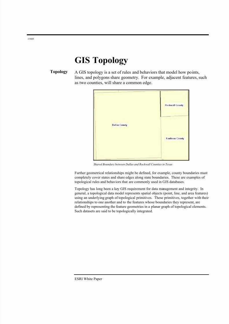
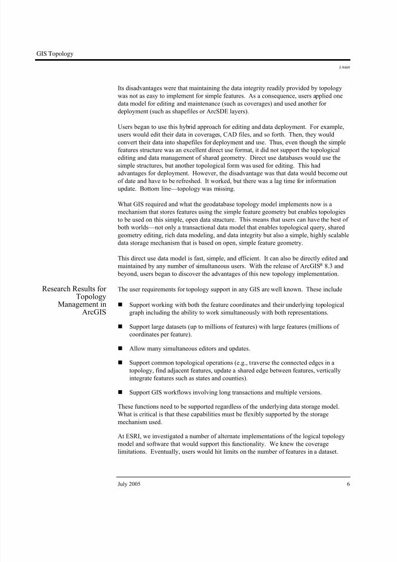
Topology A GIS topology is a set of rules and behaviors that model how points,lines, and polygons share geometry. For example, adjacent features, such
as two counties, will share a common edge.
Shared Boundary between Dallas and Rockwall Counties in Texas
Further geometrical relationships might be defined, for example, county boundaries must
completely cover states and share edges along state boundaries. These are examples of
topological rules and behaviors that are commonly used in GIS databases.
Topology has long been a key GIS requirement for data management and integrity. In
general, a topological data model represents spatial objects (point, line, and area features)
using an underlying graph of topological primitives. These primitives, together with their
relationships to one another and to the features whose boundaries they represent, are
defined by representing the feature geometries in a planar graph of topological elements.
Such datasets are said to be topologically integrated.
ESRI White Paper
8/10/2019 GIS Topology
http://slidepdf.com/reader/full/gis-topology 6/14
GIS Topology
J-9469
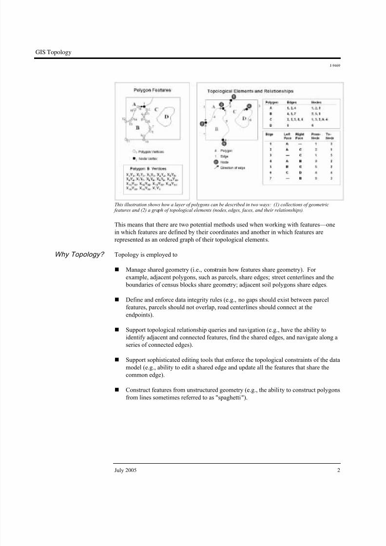
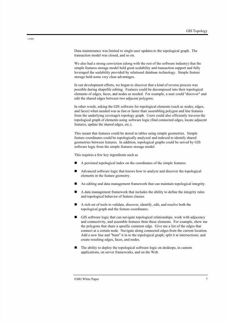
This illustration shows how a layer of polygons can be described in two ways: (1) collections of geometric features and (2) a graph of topological elements (nodes, edges, faces, and their relationships).
This means that there are two potential methods used when working with features—one
in which features are defined by their coordinates and another in which features are
represented as an ordered graph of their topological elements.
Why Topology? Topology is employed to
! Manage shared geometry (i.e., constrain how features share geometry). For
example, adjacent polygons, such as parcels, share edges; street centerlines and the
boundaries of census blocks share geometry; adjacent soil polygons share edges.
! Define and enforce data integrity rules (e.g., no gaps should exist between parcel
features, parcels should not overlap, road centerlines should connect at the
endpoints).
! Support topological relationship queries and navigation (e.g., have the ability to
identify adjacent and connected features, find the shared edges, and navigate along a
series of connected edges).
! Support sophisticated editing tools that enforce the topological constraints of the data
model (e.g., ability to edit a shared edge and update all the features that share the
common edge).
! Construct features from unstructured geometry (e.g., the ability to construct polygons
from lines sometimes referred to as "spaghetti").
July 2005 2
8/10/2019 GIS Topology
http://slidepdf.com/reader/full/gis-topology 7/14
GIS Topology
J-9469
Historical
Topological DataModel Example: TheArcInfo Coverage
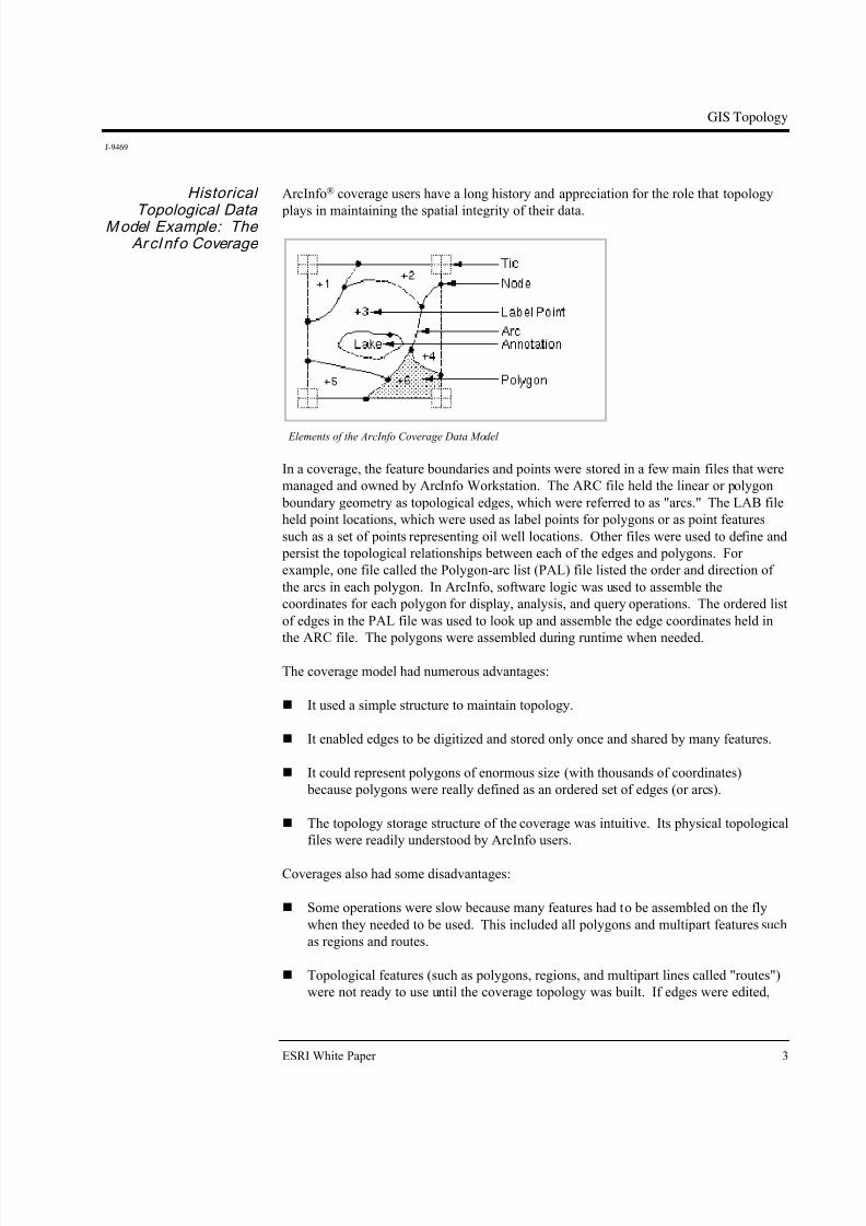
ArcInfo® coverage users have a long history and appreciation for the role that topology
plays in maintaining the spatial integrity of their data.
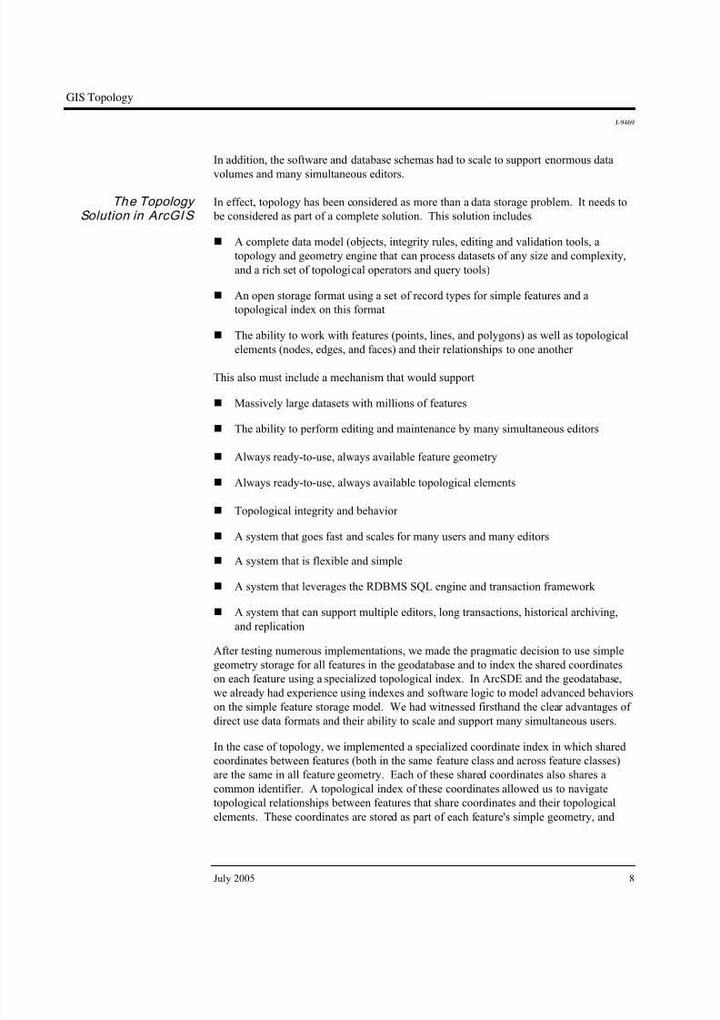
Elements of the ArcInfo Coverage Data Model
In a coverage, the feature boundaries and points were stored in a few main files that were
managed and owned by ArcInfo Workstation. The ARC file held the linear or polygon
boundary geometry as topological edges, which were referred to as "arcs." The LAB file
held point locations, which were used as label points for polygons or as point features
such as a set of points representing oil well locations. Other files were used to define and
persist the topological relationships between each of the edges and polygons. For
example, one file called the Polygon-arc list (PAL) file listed the order and direction of
the arcs in each polygon. In ArcInfo, software logic was used to assemble the
coordinates for each polygon for display, analysis, and query operations. The ordered list
of edges in the PAL file was used to look up and assemble the edge coordinates held in
the ARC file. The polygons were assembled during runtime when needed.
The coverage model had numerous advantages:
! It used a simple structure to maintain topology.
! It enabled edges to be digitized and stored only once and shared by many features.
! It could represent polygons of enormous size (with thousands of coordinates)
because polygons were really defined as an ordered set of edges (or arcs).
! The topology storage structure of the coverage was intuitive. Its physical topological
files were readily understood by ArcInfo users.
Coverages also had some disadvantages:
! Some operations were slow because many features had to be assembled on the fly
when they needed to be used. This included all polygons and multipart features such
as regions and routes.
! Topological features (such as polygons, regions, and multipart lines called "routes")
were not ready to use until the coverage topology was built. If edges were edited,
ESRI White Paper 3
8/10/2019 GIS Topology
http://slidepdf.com/reader/full/gis-topology 8/14
GIS Topology
J-9469
the topology had to be rebuilt. (Note: Partial processing was eventually used, which
required rebuilding only the changed portions of the coverage topology.) In general,when edits are made to features in a topological dataset, a geometric analysis
algorithm must be executed to rebuild the topological relationships regardless of the
storage model.
! Coverages were limited to single-user editing. Because of the need to ensure that the
topological graph was synchronized with the feature geometries, only a single user at
a time could update a topology. Users would tile their coverages and maintain a tiled
database for editing. This enabled individual users to "lock down" and edit one tile
at a time. For general data use and deployment, users would append copies of their
tiles to a mosaicked data layer.
Shapefiles and Simple
Geometry Storage
In the early 1980s, coverages were seen as a major improvement over the older polygon
and line-based systems in which polygons were held as complete loops. In these oldersystems, all the coordinates for a feature were stored in each feature's geometry. Before
the coverage and ArcInfo came along, these simple polygon and line structures were
used. These data structures were simple but had the disadvantage of double-digitized
boundaries. That is, two copies of the coordinates of adjacent portions of polygons with
shared edges would be contained in each polygon's geometry. The main disadvantage
was that GIS software of that time could not maintain shared-edge integrity. In addition,
storage costs were extremely high, and each byte of storage came at a premium. During
the early 1980s, a 300 MB disk drive was the size of a washing machine and cost
$30,000. Holding two or more representations of coordinates was expensive, and
computations took too much compute time. Thus, the use of a coverage topology had
real advantages.
During the mid-1990s, interest in simple geometric structures grew because disk storageand hardware costs in general were decreasing while computational speed was increasing.
At the same time, existing GIS datasets were more readily available, and the work of GIS
users was evolving from primarily data compilation activities to include data use,
analysis, and sharing.
Users wanted faster performance for data use (for example, do not spend computer time
to derive polygon geometries when we need them. Just deliver the feature coordinates of
these 1,200 polygons as fast as possible). Having the full-feature geometry readily
available was more efficient. Thousands of GIS systems were in use, and numerous
datasets were readily available.
Around this time, ESRI had developed and published its ESRI® shapefile format.
Shapefiles used a very simple storage model for feature coordinates. Each shapefile
represented a single feature class (of points, lines, or polygons) and used a simple storage
model for the feature's coordinates.
July 2005 4
8/10/2019 GIS Topology
http://slidepdf.com/reader/full/gis-topology 9/14
GIS Topology
J-9469
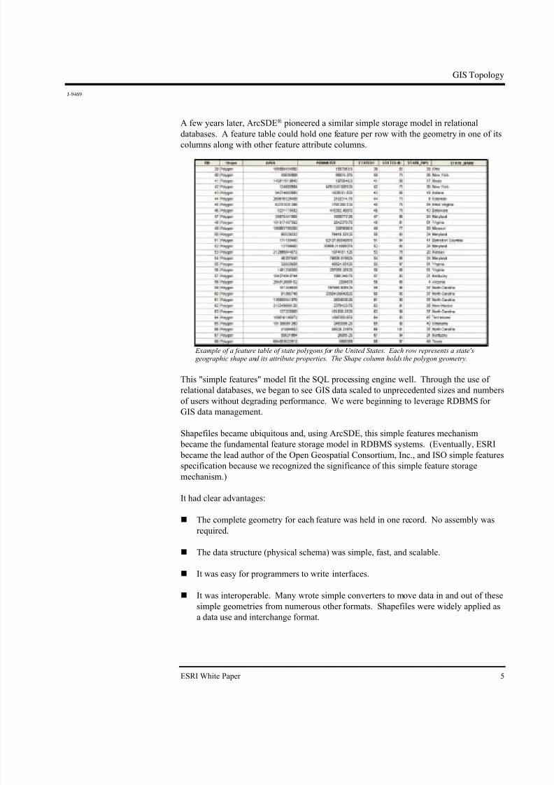
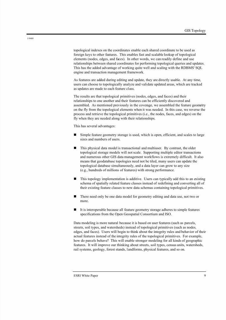
A few years later, ArcSDE® pioneered a similar simple storage model in relational
databases. A feature table could hold one feature per row with the geometry in one of itscolumns along with other feature attribute columns.
Example of a feature table of state polygons for the United States. Each row represents a state's geographic shape and its attribute properties. The Shape column holds the polygon geometry.
This "simple features" model fit the SQL processing engine well. Through the use of
relational databases, we began to see GIS data scaled to unprecedented sizes and numbers
of users without degrading performance. We were beginning to leverage RDBMS for
GIS data management.
Shapefiles became ubiquitous and, using ArcSDE, this simple features mechanism
became the fundamental feature storage model in RDBMS systems. (Eventually, ESRI
became the lead author of the Open Geospatial Consortium, Inc., and ISO simple features
specification because we recognized the significance of this simple feature storage
mechanism.)
It had clear advantages:
! The complete geometry for each feature was held in one record. No assembly was
required.
! The data structure (physical schema) was simple, fast, and scalable.
! It was easy for programmers to write interfaces.
! It was interoperable. Many wrote simple converters to move data in and out of these
simple geometries from numerous other formats. Shapefiles were widely applied as
a data use and interchange format.
ESRI White Paper 5
8/10/2019 GIS Topology
http://slidepdf.com/reader/full/gis-topology 10/14
GIS Topology
J-9469
Its disadvantages were that maintaining the data integrity readily provided by topology
was not as easy to implement for simple features. As a consequence, users applied onedata model for editing and maintenance (such as coverages) and used another for
deployment (such as shapefiles or ArcSDE layers).
Users began to use this hybrid approach for editing and data deployment. For example,
users would edit their data in coverages, CAD files, and so forth. Then, they would
convert their data into shapefiles for deployment and use. Thus, even though the simple
features structure was an excellent direct use format, it did not support the topological
editing and data management of shared geometry. Direct use databases would use the
simple structures, but another topological form was used for editing. This had
advantages for deployment. However, the disadvantage was that data would become out
of date and have to be refreshed. It worked, but there was a lag time for information
update. Bottom line—topology was missing.
What GIS required and what the geodatabase topology model implements now is a
mechanism that stores features using the simple feature geometry but enables topologies
to be used on this simple, open data structure. This means that users can have the best of
both worlds—not only a transactional data model that enables topological query, shared
geometry editing, rich data modeling, and data integrity but also a simple, highly scalable
data storage mechanism that is based on open, simple feature geometry.
This direct use data model is fast, simple, and efficient. It can also be directly edited and
maintained by any number of simultaneous users. With the release of ArcGIS® 8.3 and
beyond, users began to discover the advantages of this new topology implementation.
Research Results for
TopologyManagement in
ArcGIS
The user requirements for topology support in any GIS are well known. These include
! Support working with both the feature coordinates and their underlying topological
graph including the ability to work simultaneously with both representations.
! Support large datasets (up to millions of features) with large features (millions of
coordinates per feature).
! Allow many simultaneous editors and updates.
! Support common topological operations (e.g., traverse the connected edges in a
topology, find adjacent features, update a shared edge between features, vertically
integrate features such as states and counties).
! Support GIS workflows involving long transactions and multiple versions.
These functions need to be supported regardless of the underlying data storage model.
What is critical is that these capabilities must be flexibly supported by the storage
mechanism used.
At ESRI, we investigated a number of alternate implementations of the logical topology
model and software that would support this functionality. We knew the coverage
limitations. Eventually, users would hit limits on the number of features in a dataset.
July 2005 6
8/10/2019 GIS Topology
http://slidepdf.com/reader/full/gis-topology 11/14
GIS Topology
J-9469
Data maintenance was limited to single-user updates to the topological graph. The
transaction model was closed, and so on.
We also had a strong conviction (along with the rest of the software industry) that the
simple features storage model held great scalability and transaction support and fully
leveraged the scalability provided by relational database technology. Simple feature
storage held some very clear advantages.
In our development efforts, we began to discover that a kind of reverse process was
possible during shapefile editing. Features could be decomposed into their topological
elements of edges, faces, and nodes as needed. For example, a user could "discover" and
edit the shared edges between two adjacent polygons.
In other words, asking the GIS software for topological elements (such as nodes, edges,
and faces) when needed was as fast or faster than assembling polygon and line features
from the underlying coverage's topology graph. Users could also efficiently traverse the
topological graph of elements using software logic (find connected edges, locate adjacent
features, update the shared edges, etc.).
This meant that features could be stored in tables using simple geometries. Simple
feature coordinates could be topologically analyzed and indexed to identify shared
geometries between features. In addition, topological graphs could be served by GIS
software logic from the simple features storage model.
This requires a few key ingredients such as
! A persisted topological index on the coordinates of the simple features.
! Advanced software logic that knows how to analyze and discover the topologicalelements in the feature geometry.
! An editing and data management framework that can maintain topological integrity.
! A data management framework that includes the ability to define the integrity rules
and topological behavior of feature classes.
! A rich set of tools to validate, discover, identify, edit, and resolve both the
topological graph and the feature coordinates.
! GIS software logic that can navigate topological relationships, work with adjacency
and connectivity, and assemble features from these elements. For example, show me
the polygons that share a specific common edge. Give me a list of the edges thatconnect at a certain node. Navigate along connected edges from the current location.
Add a new line and "burn" it in to the topological graph; split it at intersections; and
create resulting edges, faces, and nodes.
! The ability to deploy the topological software logic on desktops, in custom
applications, on server frameworks, and on the Web.
ESRI White Paper 7
8/10/2019 GIS Topology
http://slidepdf.com/reader/full/gis-topology 12/14
GIS Topology
J-9469
In addition, the software and database schemas had to scale to support enormous data
volumes and many simultaneous editors.
The TopologySolution in ArcGIS
In effect, topology has been considered as more than a data storage problem. It needs to
be considered as part of a complete solution. This solution includes
! A complete data model (objects, integrity rules, editing and validation tools, a
topology and geometry engine that can process datasets of any size and complexity,
and a rich set of topological operators and query tools)
! An open storage format using a set of record types for simple features and a
topological index on this format
! The ability to work with features (points, lines, and polygons) as well as topological
elements (nodes, edges, and faces) and their relationships to one another
This also must include a mechanism that would support
! Massively large datasets with millions of features
! The ability to perform editing and maintenance by many simultaneous editors
! Always ready-to-use, always available feature geometry
! Always ready-to-use, always available topological elements
! Topological integrity and behavior
! A system that goes fast and scales for many users and many editors
! A system that is flexible and simple
! A system that leverages the RDBMS SQL engine and transaction framework
! A system that can support multiple editors, long transactions, historical archiving,
and replication
After testing numerous implementations, we made the pragmatic decision to use simple
geometry storage for all features in the geodatabase and to index the shared coordinates
on each feature using a specialized topological index. In ArcSDE and the geodatabase,
we already had experience using indexes and software logic to model advanced behaviors
on the simple feature storage model. We had witnessed firsthand the clear advantages of
direct use data formats and their ability to scale and support many simultaneous users.
In the case of topology, we implemented a specialized coordinate index in which shared
coordinates between features (both in the same feature class and across feature classes)
are the same in all feature geometry. Each of these shared coordinates also shares a
common identifier. A topological index of these coordinates allowed us to navigate
topological relationships between features that share coordinates and their topological
elements. These coordinates are stored as part of each feature's simple geometry, and
July 2005 8
8/10/2019 GIS Topology
http://slidepdf.com/reader/full/gis-topology 13/14
GIS Topology
J-9469
topological indexes on the coordinates enable each shared coordinate to be used as
foreign keys to other features. This enables fast and scalable lookup of topologicalelements (nodes, edges, and faces). In other words, we can readily define and use
relationships between shared coordinates for performing topological queries and updates.
This has the added advantage of working quite well and scaling with the RDBMS' SQL
engine and transaction management framework.
As features are added during editing and update, they are directly usable. At any time,
users can choose to topologically analyze and validate updated areas, which are tracked
as updates are made to each feature class.
The results are that topological primitives (nodes, edges, and faces) and their
relationships to one another and their features can be efficiently discovered and
assembled. As mentioned previously in the coverage, we assembled the feature geometry
on the fly from the topological elements when it was needed. In this case, we reverse the
process and retrieve the topological primitives (i.e., the nodes, faces, and edges) on the
fly when they are needed along with their relationships.
This has several advantages:
! Simple feature geometry storage is used, which is open, efficient, and scales to large
sizes and numbers of users.
! This physical data model is transactional and multiuser. By contrast, the older
topological storage models will not scale. Supporting multiple editor transactions
and numerous other GIS data management workflows is extremely difficult. It also
means that geodatabase topologies need not be tiled, many users can update the
topological database simultaneously, and a data layer can grow to any size
(e.g., hundreds of millions of features) with strong performance.
! This topology implementation is additive. Users can typically add this to an existing
schema of spatially related feature classes instead of redefining and converting all of
their existing feature classes to new data schemas containing topological primitives.
! There need only be one data model for geometry editing and data use, not two or
more.
! It is interoperable because all feature geometry storage adheres to simple features
specifications from the Open Geospatial Consortium and ISO.
Data modeling is more natural because it is based on user features (such as parcels,streets, soil types, and watersheds) instead of topological primitives (such as nodes,
edges, and faces). Users will begin to think about the integrity rules and behavior of their
actual features instead of the integrity rules of the topological primitives. For example,
how do parcels behave? This will enable stronger modeling for all kinds of geographic
features. It will improve our thinking about streets, soil types, census units, watersheds,
rail systems, geology, forest stands, landforms, physical features, and so on.
ESRI White Paper 9
8/10/2019 GIS Topology
http://slidepdf.com/reader/full/gis-topology 14/14
GIS Topology
J-9469
July 2005 10
It provides the same information content as persisted topological implementations—
either users store a topological line graph and discover the feature geometry or they storethe feature geometry and discover the topological elements and relationships.
In cases in which users want to store the topological primitives, it is easy to create and
post topologies and their relationships to tables for various analytical and interoperability
purposes (such as users who wish to post their features into an Oracle Spatial warehouse
that stores tables of topological primitives).
At a pragmatic level, the ArcGIS topology implementation works. It scales to extremely
large geodatabases and multiuser systems without loss of performance. It includes rich
validation and editing tools for building and maintaining topologies in geodatabases. It
includes rich and flexible data modeling tools that enable users to assemble practical,
working systems on any relational database and any number of schemas.