Embed Size (px)
Citation preview
1
Putting Gillnet Bycatch of Seabirds on the Map in Japan
Hotspot Map Report
Yasuko Suzuki1, Yutaka Yamamoto2, Hiroko Okamoto2, Nobuhiko Sato3,
Yann Rouxel4, and Ana Carneiro1
1BirdLife International; 2Wild Bird Society of Japan;
3Atmosphere and Ocean Research Institute, University of Tokyo; 4The Royal Society for the Protection of Birds
Introduction
Bycatch in fisheries has been identified as one of the biggest threats to seabird populations globally, with up to 400,000 seabirds killed each year in gillnet fisheries alone. However, no effective mitigation measures have yet been identified for gillnet fisheries. A bycatch mitigation trial in collaboration with a local fisher from Teuri Island, Hokkaido in 2016 confirmed that seabird bycatch occurs in this fishery, but data on seabird bycatch at a nationwide scale are severely limited. The objective of this project was to build on that first step to address seabird bycatch issue in gillnet fisheries in Japan, by developing a nation-wide map to identify where bycatch is likely to happen. This is a crucial step to identify priority ports from which to conduct more detailed data collection and mitigation testing, and will also highlight critical knowledge gaps. Based on a global review of seabird bycatch in gillnet fisheries by Žydelis et al (2013), 10 diving seabird species breeding in Japan are considered susceptible to gillnet were selected for Japan-wide scale hotspot analysis and mapping.
Methods Japan-wide scale hotspots were identified by using the datasets and information below. 1) Seabird colony locations, colony sizes, and foraging areas Ten diving seabird species breeding in Japan that are susceptible to gillnet bycatch were considered in the nation-wide hotspot map (Table 1). Using the Seabird Breeding Colony Database maintained by the Ministry of Environment (MoE) in Japan, with additional information identified through literature review, we compiled breeding colony information (location and colony size) for nine out of the 10 diving species from a 20-year long dataset (1998-2017). The majority of data (94%) were from 2010-2017. Colony data from 2015-2018 on great cormorants was compiled from datasets managed by prefectural governments because of data gaps in the aforementioned database. The original data matrix for colony sizes was a mixture of estimated numbers of individuals and nests. We took the simplest approach to estimate numbers of individuals from numbers of nests (multiplied by 2) because other approaches applicable to
2
certain species were not appropriate for others. In order to estimate the foraging areas for each species, foraging distances were identified in the BirdLife International Seabird Foraging Area Database (based on published literature and databases not open to the public). The mean of maximum foraging distances (as radii) from multiple breeding colonies of each species were used if this information was available (Table 1). Maximum foraging distance, unpublished data, or expert opinion was used for other species. Table 1. Species, conservation status, and foraging distance of diving seabirds breeding in Japan and considered particularly susceptible to bycatch in gillnet fisheries.
Species Conservation status in Japan’s Red Data Book
Foraging distance (used as radius in km from center of each breeding colony)
Great cormorant Least concern 15 2,4
Japanese cormorant Least concern 34 2
Red-faced cormorant Critically endangered 5 3
Pelagic cormorant Endangered 10 3
Common murre Critically endangered 84 3
Spectacled guillemot Vulnerable 5 3
Ancient murrelet Critically endangered 67 3
Japanese murrelet Vulnerable 36 3
Rhinoceros auklet Least concern 100 1,3
Tufted puffin Critically endangered 30 3 1 Mean of maximum distances, 2 maximum distance, 3 unpublished data, 4 expert opinion 2) Gillnet fisheries annual catch and fishing areas A questionnaire to collect fisheries data, including detailed information on fishing methods, was distributed to 39 prefectures with coastal lines, where gillnet fisheries are active. The availability of detailed fisheries data greatly varied by prefecture. We could not reflect those data as consistent data matrix throughout the prefectures was necessary for a nation-wide analysis. We instead used annual catch data in gillnet fisheries collected at a local scale through marine fisheries production surveys conducted by the Ministry of Agriculture, Forestry, and Fisheries as a proxy for gillnet fishing effort. Median annual catch across the three year period from 2015-2017 for each prefecture was used. Spatial data for areas where gillnet fisheries are authorized were also collected. Rights to fish using gillnets in Japan can be obtained through two approaches, Class 2 Common Fisheries and governor’s permits. Information on areas where gillnet fishing is permitted under Class 2 Common Fisheries was obtained from MDA Situational Indication Linkages (https://www.msil.go.jp/). Information on gillnet fisheries areas permitted under governor’s permits was not readily available, even through direct conversations with prefectural governments. Fishing areas for drift gillnets were also unidentifiable in most prefectures because fishing grounds move through vast areas seasonally and annually. Thus, gillnet fishing areas reported in this document are partial and only based on Class 2 Common Fisheries information (hereafter referred to as “permitted gillnet fishing areas”). This limitation in the current analysis is not negligible, and filling the knowledge gap will be necessary for more comprehensive spatial analysis of bycatch risk in gillnet fisheries.
3
3) Water depth Set gillnets in Japan are mostly bottom set, thus water depth was considered an important factor to identify seabird bycatch in gillnets. Bathymetry data for the coastal waters of Japan were acquired from the Japanese Oceanographic Data Center. The data allowed us to draw contours at 100m, assuming deep diving seabirds breeding in Japan would not dive deeper based on literature review. The 100m cut-off for water depth is also supported by information provided by fishers we interviewed in Hokkaido and the northeastern part of Japan; seabird bycatch has not been observed in gillnets set deeper than 100m (see #4 below for details). 4) Supporting information through interviews with fishers and local fisheries associations During an early phase of the hotspot map analysis, we identified four areas where gillnet bycatch risk was potentially high based on seabird colony concentration and annual fish catch data; the southwest, northwest, and eastern regions of a northern island (Hokkaido) as well as the northeastern region of main island (Honshu). We conducted in-person interviews with fishers and local fisheries associations in those regions. Seabird bycatch was confirmed in eastern and northwestern Hokkaido as well as Miyagi prefecture. In Miyagi, no seabird bycatch was reported in fisheries targeting olive flounder and cod at water depths of 100m, while bycatch has occurred in fisheries targeting mantis shrimp and flounder at water depths of 10-20m. In southwestern Hokkaido, where gillnet fisheries target Okhotsk atka mackerel and Japanese rock fish at water depth at 120-150m, seabird bycatch was reported as very rare. Although not based on scientific data collection, those interviews provided valuable information, especially as they supported the hypothesis of the importance of water depth in bycatch analysis.
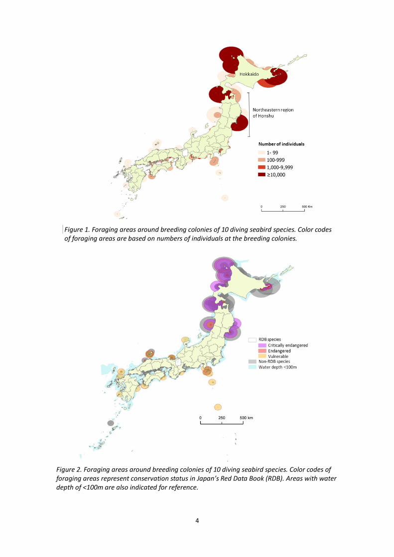
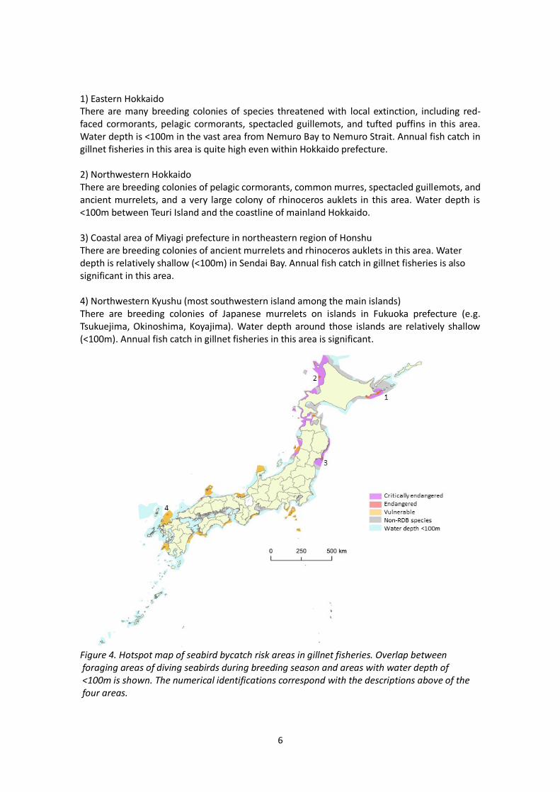
ArcGIS was used to create data layers for breeding seabird distribution, gillnet fishing effort/areas, and bathymetry, to build a series of maps including a gillnet bycatch hotspot map. Results Seabird breeding colony distribution and foraging ranges Mapping of the 10 diving seabird species identified concentrations of seabird breeding colonies in Hokkaido and the northeastern region of Honshu (Figure 1). Nine and seven diving species were confirmed breeding in Hokkaido and NE region of Honshu, respectively. In contrast, 2-4 diving seabird species were breeding in other regions. The total number of individuals of those species were the highest in Hokkaido, an order of magnitude higher than the sum of individuals in the rest of Japan. The high number of diving seabirds in Hokkaido during the breeding season is mainly attributed to large colonies of rhinoceros auklets (one site on the northwestern coast is the largest colony of the species in the world with >758,000 individuals, Figure 1). Hokkaido and the northeastern region of Honshu collectively host colonies of six species of conservation concern (four critically endangered [red-faced cormorant, common murre, ancient murrelet, tufted puffin], one endangered [pelagic cormorant], and two vulnerable species [spectacled guillemot, Japanese murrelet], Table 1) in Japan’s Red Data Book (Figure 2). Three species with relatively large foraging areas (radii >50km: common murres, ancient murrelets, and rhinoceros auklets) are also concentrated in these two regions.
4
Figure 1. Foraging areas around breeding colonies of 10 diving seabird species. Color codes of foraging areas are based on numbers of individuals at the breeding colonies.
Figure 2. Foraging areas around breeding colonies of 10 diving seabird species. Color codes of foraging areas represent conservation status in Japan’s Red Data Book (RDB). Areas with water depth of <100m are also indicated for reference.

5
Gillnet fisheries annual catch and fishing areas Annual catch in gillnet fisheries in Hokkaido prefecture was by far the largest compared to other prefectures (Figure 3). The second largest annual catch was observed in Miyagi prefecture (4,094 t) in the northeastern region of Honshu, but it was an order of magnitude lower than that of Hokkaido (78,720 t). Permitted gillnet fishing areas were observed in most prefectures with coastlines. The permitted areas for gillnetting are larger in Hokkaido prefecture than other prefectures. Areas with a water depth of <100m extend further offshore from the permitted gillnet fishing areas in some regions (e.g. eastern Hokkaido).
Figure 3. Annual fish catch in gillnet fisheries by prefecture and permitted areas for
gillnet fishing (only Class 2 Common Fisheries areas are shown). Areas with water depth of <100m are also indicated.
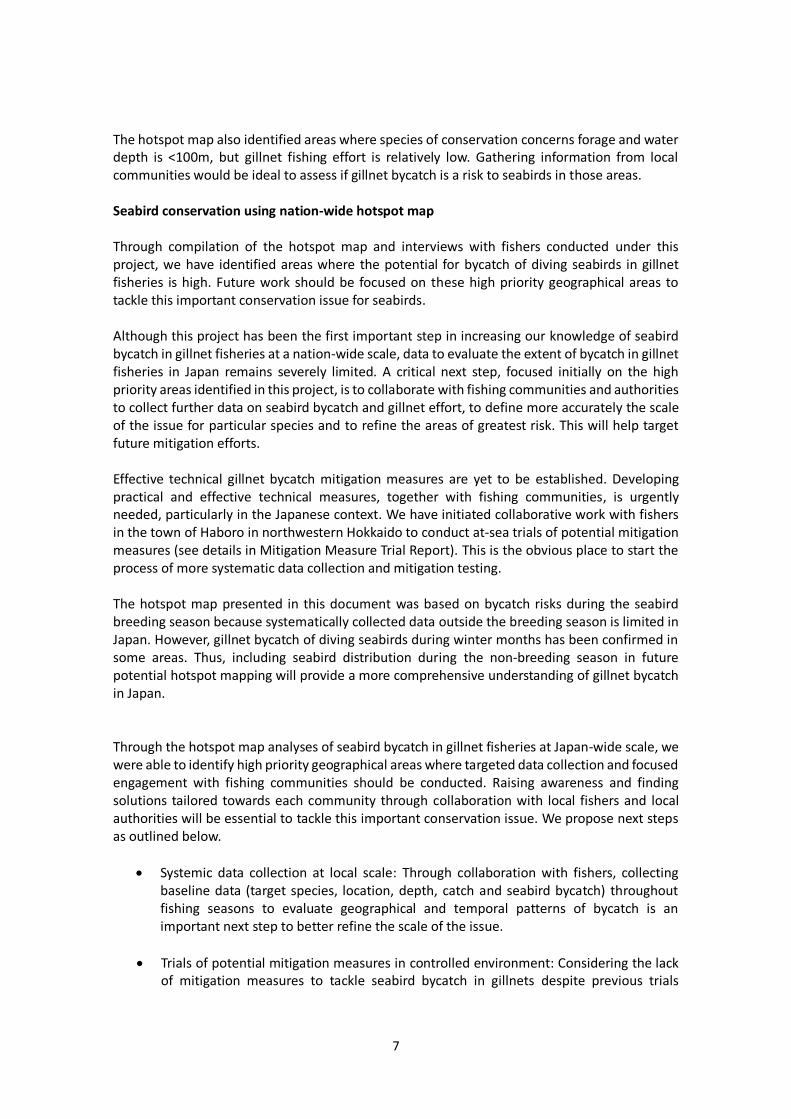
Potential seabird bycatch hotspots in gillnet fisheries By layering seabird colony and foraging range information with areas with water depth of <100m on a map, we identified areas where diving seabirds and gillnet fisheries overlap in Japanese waters (Figure 4). We used water depth information instead of permitted areas for gillnet fisheries because the aforementioned governor’s permit (for which we do not have data) allows gillnet fisheries beyond the permitted areas shown in Figure 3 – this is therefore a slightly precautionary approach to considering potential bycatch hotspots. Based on the gillnet bycatch hotspot map (Figure 4) and annual fish catch information (Figure 3), four areas where bycatch risk is expected to be high were identified:
6
1) Eastern Hokkaido There are many breeding colonies of species threatened with local extinction, including red-faced cormorants, pelagic cormorants, spectacled guillemots, and tufted puffins in this area. Water depth is <100m in the vast area from Nemuro Bay to Nemuro Strait. Annual fish catch in gillnet fisheries in this area is quite high even within Hokkaido prefecture. 2) Northwestern Hokkaido There are breeding colonies of pelagic cormorants, common murres, spectacled guillemots, and ancient murrelets, and a very large colony of rhinoceros auklets in this area. Water depth is <100m between Teuri Island and the coastline of mainland Hokkaido. 3) Coastal area of Miyagi prefecture in northeastern region of Honshu There are breeding colonies of ancient murrelets and rhinoceros auklets in this area. Water depth is relatively shallow (<100m) in Sendai Bay. Annual fish catch in gillnet fisheries is also significant in this area. 4) Northwestern Kyushu (most southwestern island among the main islands) There are breeding colonies of Japanese murrelets on islands in Fukuoka prefecture (e.g. Tsukuejima, Okinoshima, Koyajima). Water depth around those islands are relatively shallow (<100m). Annual fish catch in gillnet fisheries in this area is significant.
Figure 4. Hotspot map of seabird bycatch risk areas in gillnet fisheries. Overlap between foraging areas of diving seabirds during breeding season and areas with water depth of <100m is shown. The numerical identifications correspond with the descriptions above of the four areas.
7
The hotspot map also identified areas where species of conservation concerns forage and water depth is <100m, but gillnet fishing effort is relatively low. Gathering information from local communities would be ideal to assess if gillnet bycatch is a risk to seabirds in those areas. Seabird conservation using nation-wide hotspot map Through compilation of the hotspot map and interviews with fishers conducted under this project, we have identified areas where the potential for bycatch of diving seabirds in gillnet fisheries is high. Future work should be focused on these high priority geographical areas to tackle this important conservation issue for seabirds. Although this project has been the first important step in increasing our knowledge of seabird bycatch in gillnet fisheries at a nation-wide scale, data to evaluate the extent of bycatch in gillnet fisheries in Japan remains severely limited. A critical next step, focused initially on the high priority areas identified in this project, is to collaborate with fishing communities and authorities to collect further data on seabird bycatch and gillnet effort, to define more accurately the scale of the issue for particular species and to refine the areas of greatest risk. This will help target future mitigation efforts. Effective technical gillnet bycatch mitigation measures are yet to be established. Developing practical and effective technical measures, together with fishing communities, is urgently needed, particularly in the Japanese context. We have initiated collaborative work with fishers in the town of Haboro in northwestern Hokkaido to conduct at-sea trials of potential mitigation measures (see details in Mitigation Measure Trial Report). This is the obvious place to start the process of more systematic data collection and mitigation testing. The hotspot map presented in this document was based on bycatch risks during the seabird breeding season because systematically collected data outside the breeding season is limited in Japan. However, gillnet bycatch of diving seabirds during winter months has been confirmed in some areas. Thus, including seabird distribution during the non-breeding season in future potential hotspot mapping will provide a more comprehensive understanding of gillnet bycatch in Japan. Through the hotspot map analyses of seabird bycatch in gillnet fisheries at Japan-wide scale, we were able to identify high priority geographical areas where targeted data collection and focused engagement with fishing communities should be conducted. Raising awareness and finding solutions tailored towards each community through collaboration with local fishers and local authorities will be essential to tackle this important conservation issue. We propose next steps as outlined below.
Systemic data collection at local scale: Through collaboration with fishers, collecting baseline data (target species, location, depth, catch and seabird bycatch) throughout fishing seasons to evaluate geographical and temporal patterns of bycatch is an important next step to better refine the scale of the issue.
Trials of potential mitigation measures in controlled environment: Considering the lack of mitigation measures to tackle seabird bycatch in gillnets despite previous trials

8
conducted in multiple countries, developing effective and practical methods through experiments is urgently needed, especially in a controlled setting such as an aquarium that holds seabird species of interest (e.g. alcids).
Full at-sea trials of the most promising mitigation measures: Informed by outcomes of the experiments in a controlled setting, conducting full-scale at-sea trials with sufficient scale for statistical analysis would be an essential step to evaluate effectiveness and practicality of the mitigation.
Community-based engagement: Strengthen our collaboration with northwestern Hokkaido fishers, and engage in further grassroots activities with new fishing communities identified in the bycatch hotspots analysis are much needed steps to tackle the bycatch issue.
Acknowledgements This project was made possible by support from the Kingfisher Foundation, to whom we are very grateful. We would like to thank prefectural governments for providing gillnet fisheries information through the questionnaire and direct correspondence. We very much appreciate fishers and local fisheries associations for their generosity to share knowledge of gillnet fisheries. We also thank Japan Coast Guard for providing data on areas permitted for gillnet fisheries under Common Fisheries Rights. We would like to extend our appreciation to the following organizations and individuals for sharing information on seabird colonies and foraging distances as well as providing technical support to develop the hotspot map: Ministry of Environment, prefectural governments (Regional Councils of Tohoku, Kanto, Chubu Kinki, and Chugoku Shikoku), Bird Research, Kyle Elliott, Scott Hatch, Seiji Hayama, Kentaro Kazama, Mami Kazama, Tagaki Kentaro, Jumpei Okado, Kuniko Otsuki, Akiko Shoji and Yutaka Watanuki.
9
Literature cited Zydelis, R., C. Small and G. French. 2013. The incidental catch of seabirds in gillnet fisheries: a
global review. Biological Conservation 162: 76–88. Blow are literature used for seabird colony information Otsuki, K. et al. 2017. Summary of the breeding status for the Japanese Crested Murrelet.,
Status and Monitoring of Rare and Threatened Japanese Crest Murrelet. Marine Bird Restoration Group Publication. 1:15-32, Fukushima prefecture.
小城春雄、笠康三郎 . 2001. 渡島大島におけるオオミズナギドリ繁殖個体群の現状と保全への指
針. 北海道大学水産科学研究彙報 52(2):71-93.
環境省自然環境局. 2018. 平成 29 年度特定鳥獣(鳥類)に関わる保護管理検討調査業務報告書
環境省自然環境局. 2016, 2017. 平成 27, 28 年度カワウ広域保護管理にかかる情報収集・分析及
び課題整理等推進業務報告書
環境省自然環境局生物多様性センター. 2008-2011, 2013, 2017-2018. 重要生態系監視地域モニ
タリング推進事業(モニタリングサイト 1000)海鳥調査業務報告書.環境省.山梨県.
http://www.biodic.go.jp/moni1000/findings/reports/pdf/h19_seabirds.pdf http://www.biodic.go.jp/moni1000/findings/reports/pdf/h20_seabirds.pdf http://www.biodic.go.jp/moni1000/findings/reports/pdf/h21_seabirds.pdf http://www.biodic.go.jp/moni1000/findings/reports/pdf/h22_seabirds.pdf http://www.biodic.go.jp/moni1000/findings/reports/pdf/h24_seabirds.pdf http://www.biodic.go.jp/moni1000/findings/reports/pdf/h28_seabirds.pdf http://www.biodic.go.jp/moni1000/findings/reports/pdf/h29_seabirds.pdf
北海道海鳥保全研究会編. 2015-2018. 北の海鳥. 1-7 号.北海道海鳥保全研究会.