Embed Size (px)
Citation preview
Agris on-line Papers in Economics and Informatics
Volume IV Number 3, 2012
[71]
Information Support of Regions and Possibilities of Its Further Development J. Vaněk, M. Stočes, P. Šimek, I. Hrbek
Faculty of Economics and Management, Czech University of Life Science in Prague, Czech Republic
AnotacePříspěvek prezentuje výsledky výzkumu podpory rozvoje informačních a komunikačních technologií (ICT) v regionech ČR zaměřené především na problematiku mapování kulturního dědictví spolu s aktivitami v oblasti cestovního ruchu a s nimi spojené podnikatelské aktivity (ubytování, stravování, apod.). Na příkladu řešení webového portálu „Poznej Pošumaví – turistický průvodce po Pošumaví“ je demonstrován možný přístup, který integruje výhody klasických informačních zdrojů s internetovou aplikací, která navíc poskytuje přehledný mapový výstup. Realizace projektu je prováděna ve spolupráci s vybraným místním partnerem, kterým je zde LAG Pošumaví. Uvedené řešení je možné případně dále dle potřeby rozšířit, ale také chápat jako univerzální, tedy s širokým využitím v dalších oblastech informační podpory regionů.
Klíčová slovaZavádění informačních a komunikačních technologií, vysokorychlostní internet, cestovní ruch, regionální rozvoj, webový portál.
AbstractThe paper presents the results of information and communication technologies (ICT) research support in the Czech Republic regions, focused mainly on the problems of mapping cultural heritage together with activities in the area of tourism and business activities connected with it (accommodation, food etc). One possible approach is demonstrated on the example of web portal “Get to know Posumavi – a tourist guide to Posumavi”. This approach integrates the advantages of standard information sources with the Internet application. Moreover, this application provides a clear topographical output. The project is being prepared in co-operation with a chosen local partner, in our case the Posumavi local action group. The under-mentioned solution can be further extended if need be, but we can also understand it as a general-purpose solution which means it can be widely used in other areas of the information support of regions.
The knowledge and data presented in the paper were obtained as a result of the Research Program titled “Economy of the Czech Agriculture Resources and Their Efficient Use within the Framework of the Multifunctional Agri-food Systems” of the Czech Ministry of Education, Youth and Sports number VZ MSM 6046070906.
Key wordsICT adoption, broadband, tourism, regional development, web portal.
IntroductionInformation on regional level is currently produced, offered and provided by a number of sources and information channels, from the simplest forms such as leaflets and other printed materials to the Internet information sources. The quality of these materials obviously differs and it depends to a large extent on the concept and support on the regional level (regions, counties, villages and towns, cultural sights etc.) There exist various approaches and concepts which are often incompatible or
contradictory. In some cases they are not even interconnected or all embracing. This concerns a number of areas including: tourism, the support of business activities more or less connected with tourism and the promotion of local cultural heritage.
Among subjects that can play a relatively important role in this area are Local Action Groups – LAGs). A lot of LAGs are really dynamic subjects supporting the development of various activities in their region. The Department of Information Technologies (the Faculty of Economics and Management, the Czech
[72]
Information Support of Regions and Possibilities of Its Further Development
University of Life Sciences) cooperates in the long term for example with the Posumavi LAG.
The Posumavi local action group is a voluntary association of towns, rural micro-regions, business people and nonprofit organizations who operate in southwestern Bohemia. It primarily focuses its activities on the regional development by means of collecting financial means from various sources and by coordinating individual subjects’ activities which are in progress in the given area. Among areas with wide support are the surveying of cultural heritage and activities in the sphere of tourism and business activities linked to it. A number of activities are connected to the development of information and communication technologies and its use in the regional environment where the cooperation with the Department of Information Technologies (DIT) is being used.
As far as foreign literature is concerned, some relevant and interesting impetus is emphasized in, for example, [3]. Even though it covers the regional environment in Australia, the principles are general ones:
“…highlighting the need for destination stakeholders to foster a cooperative and strategic approach and ensure consistent design and delivery of a destination brand and image which is supported by tactical advertising and promotional strategies, effective visitor information services, and events to support the destination brand and image to target appropriate visitor markets.”
The problems of integrated information systems are being solved not only in our regional conditions. The construction of integrated information systems is relevant for example to the environment of China and other Asian countries - see [6]. Regional tourism and web applications are being solved in the conditions of Australia [2], New Zealand [1, 4] or Europe [5]. General recommendations and evaluations are described for example in [7].
On the contrary, our official documents don’t deal with the above mentioned problems at all (if we ignore several and only partially general phrases) - see for example [8]. The main initiative has always rested with various regional subjects.
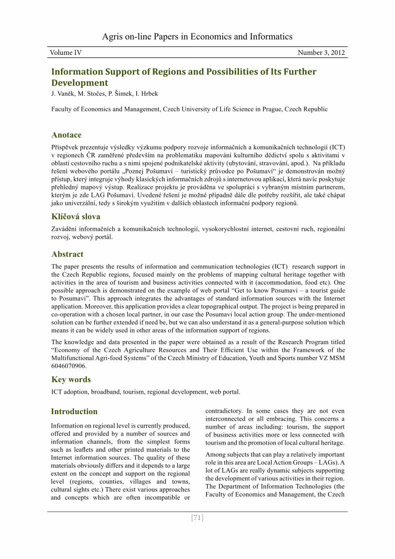
Objectives and methodsSince 2011 DIT has been - in cooperation with local partner the Posumavi LAG – working on the solution of concept and implementation of web pages (portal) “Get to know Posumavi – a tourist guide to Posumavi” project (for the homepage of this portal see picture 1).
Note: the global intention and solution results are shown in the pictures (screens) of the portal testing solution - English or Czech version.
The task of the solution is to improve tourism potential in the area concerned (the area of the Posumavi LAG in our case) via modern software solution combined with topographical and other sources. The solution as a whole tries to integrate the problems of tourism by a unified approach in several partial views which classify the objects into five basic groups. At the same time it aims to use already existing information sources or to support their wider circulation. Furthermore, a clear topographical output is presented and information search by a number of criteria is supported. In this way, a complex information system is created which - after the input of data - maps the offer of the given area for tourists and potential visitors. The users are therefore able to familiarize themselves with the area and read a lot of information (or print it for their later needs) in advance.
The tourist guide introduces the particular, from the tourists’ point of view very interesting site from several defined partial views which can generally be applied to the given area of interest (Accommodation, Food, Villages and Towns, Activities, Attractions). The above mentioned division belongs (together with the topographical output, search and contacts information) to the basic offer of the portal functions (see picture 1].
The above mentioned views enable to classify the objects of the region by the most important activities or attributes concerning the global focus on tourism and business support in that particular region. Every object is allowed to have one activity (attribute) and several follow-up ones.
Accommodation – objects primarily with standard accommodation services. Various categories and special offers, often linked to the region. The possibility of catering and other activities.
Food – objects offering food. Standard services of providing meals or special offers according to the special characteristics of the region (e.g. regional specialities and foodstuff).
Villages and towns – the introduction and promotion of sites in the given area. Furthermore, it draws attention to the villages and towns of the region and to the most interesting sights (from the tourists’ point of view).
Activities – the introduction and promotion of various activities available in the region. Classification in an independent category allows simpler orientation in the area’s offer.
[73]
Information Support of Regions and Possibilities of Its Further Development
Attractions – an independent category to make available and promote cultural sights, natural sights and national parks, interesting places etc.
Because of the proximity of our borders with Germany and the potential of foreign tourists the solution is carried out as multilingual (Czech, German, English).
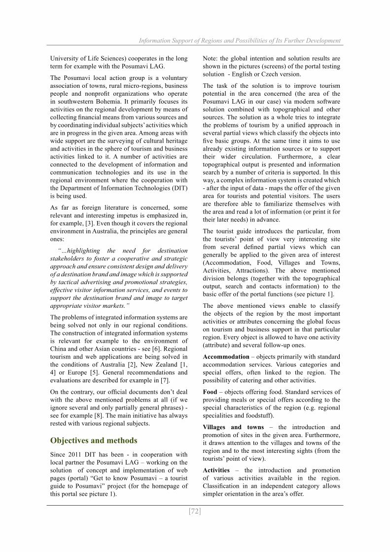
Portal “Get to Know Posumavi” makes accessible other interesting web projects run by the LAG as well: explicitly “Local Heritage” and “Get to Know your Neighbour”. This is put into practice by options in the top right-hand corner of the web presentation, next to the options enabling to
change portal’s language versions. Visitors to web presentation are in this way able to switch over to other applications which were originally prepared as separate solutions and which by their content belong to this particular topic and area and create an important supplement to the information value of the whole system. The change of language versions, search and integration of other web portals are shown in picture 2.
The web presentation offers (within the frame of individual views of all listed objects) information on three levels: Basic information – Details – Special information leaflet. All of them can be seen
Picture 1. Homepage of the portal (English version) - application testing.
Picture 2. The change of language versions, the integration of other web portals and search.
[74]
Information Support of Regions and Possibilities of Its Further Development
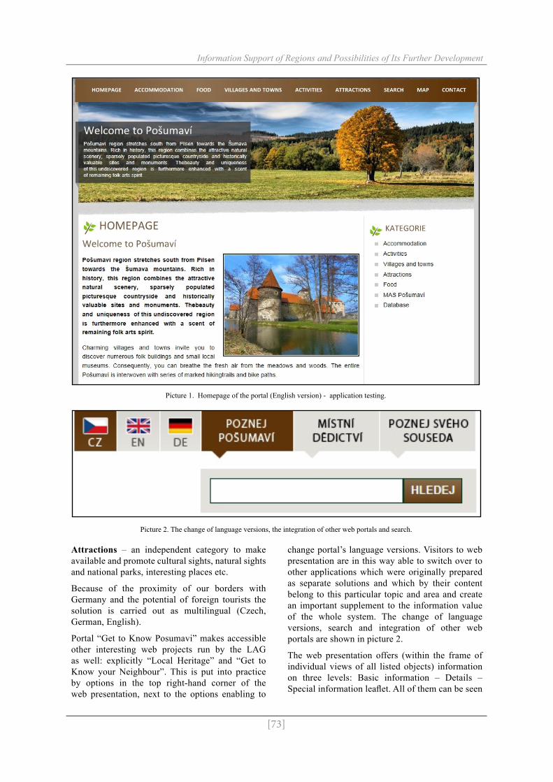
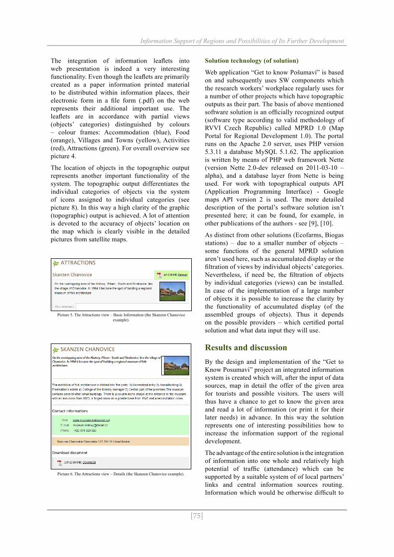
on the web, printed and used as a basic guide to trips around Posumavi. The scheme of the provided information individual levels is shown in picture 3. Detailed examples of output are shown in pictures 5 to 7. Here it is demonstrated on the Skanzen Chanovice object.
Basic information – primary information about the object concerned. It comprises short descriptive information and a picture of the object. Furthermore, it enables to open details (switch to details about the object) and download or display the information leaflet in .pdf format.
Details – comprise basic information completed with information about contacts (www, e-mail addresses, phone numbers, addresses, GPS coordinates, etc.) and a picture gallery. And it enables to download or display the information leaflet in .pdf format as well.
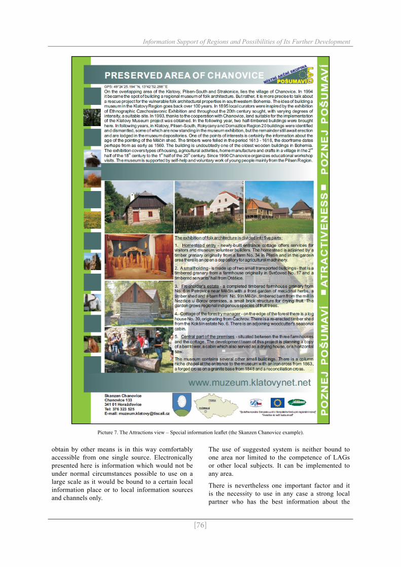
Special information leaflet – one page detailed colour information leaflet about the given object with colour photographs. It represents the official publicity printed material which is primarily available in the paper form of high quality but with the intension of the electronic version’s simultaneous creation.
Picture 3. The overview of output levels.
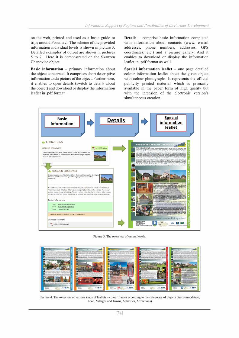
Picture 4. The overview of various kinds of leaflets – colour frames according to the categories of objects (Accommodation, Food, Villages and Towns, Activities, Attractions).
[75]
Information Support of Regions and Possibilities of Its Further Development
The integration of information leaflets into web presentation is indeed a very interesting functionality. Even though the leaflets are primarily created as a paper information printed material to be distributed within information places, their electronic form in a file form (.pdf) on the web represents their additional important use. The leaflets are in accordance with partial views (objects’ categories) distinguished by colours – colour frames: Accommodation (blue), Food (orange), Villages and Towns (yellow), Activities (red), Attractions (green). For overall overview see picture 4.
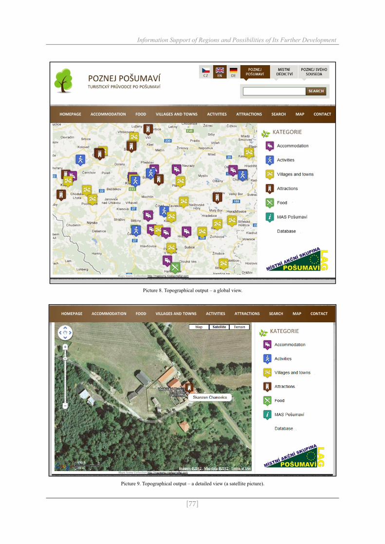
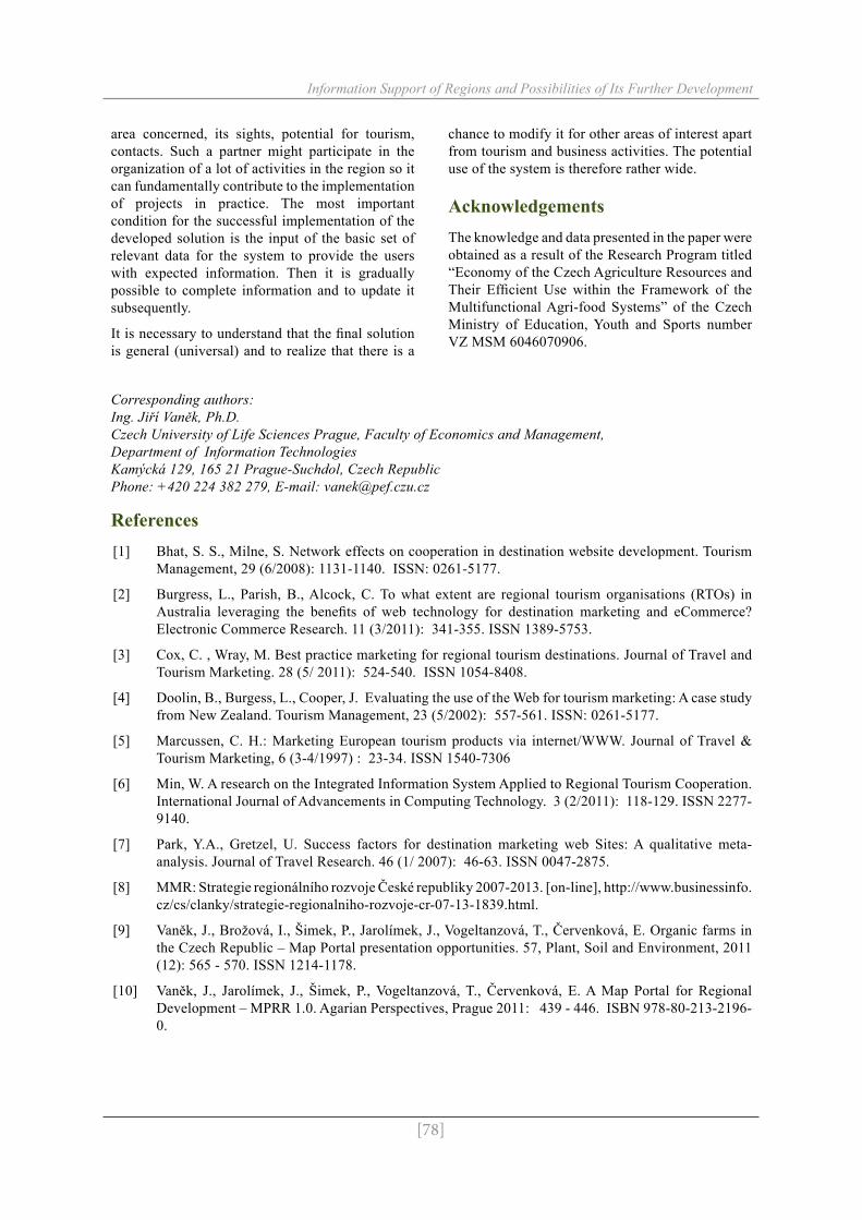
The location of objects in the topographic output represents another important functionality of the system. The topographic output differentiates the individual categories of objects via the system of icons assigned to individual categories (see picture 8). In this way a high clarity of the graphic (topographic) output is achieved. A lot of attention is devoted to the accuracy of objects’ location on the map which is clearly visible in the detailed pictures from satellite maps.
Picture 5. The Attractions view – Basic Information (the Skanzen Chanovice example).
Picture 6. The Attractions view – Details (the Skanzen Chanovice example).
Solution technology (of solution)
Web application “Get to know Pošumaví” is based on and subsequently uses SW components which the research workers’ workplace regularly uses for a number of other projects which have topographic outputs as their part. The basis of above mentioned software solution is an officially recognized output (software type according to valid methodology of RVVI Czech Republic) called MPRD 1.0 (Map Portal for Regional Development 1.0). The portal runs on the Apache 2.0 server, uses PHP version 5.3.11 a database MySQL 5.1.62. The application is written by means of PHP web framework Nette (version Nette 2.0-dev released on 2011-03-10 – alpha), and a database layer from Nette is being used. For work with topographical outputs API (Application Programming Interface) - Google maps API version 2 is used. The more detailed description of the portal’s software solution isn’t presented here; it can be found, for example, in other publications of the authors - see [9], [10].
As distinct from other solutions (Ecofarms, Biogas stations) – due to a smaller number of objects – some functions of the general MPRD solution aren’t used here, such as accumulated display or the filtration of views by individual objects’ categories. Nevertheless, if need be, the filtration of objects by individual categories (views) can be installed. In case of the implementation of a large number of objects it is possible to increase the clarity by the functionality of accumulated display (of the assembled groups of objects). Thus it depends on the possible providers – which certified portal solution and what data input they will use.
Results and discussionBy the design and implementation of the “Get to Know Posumavi” project an integrated information system is created which will, after the input of data sources, map in detail the offer of the given area for tourists and possible visitors. The users will thus have a chance to get to know the given area and read a lot of information (or print it for their later needs) in advance. In this way the solution represents one of interesting possibilities how to increase the information support of the regional development.
The advantage of the entire solution is the integration of information into one whole and relatively high potential of traffic (attendance) which can be supported by a suitable system of of local partners’ links and central information sources routing. Information which would be otherwise difficult to
[76]
Information Support of Regions and Possibilities of Its Further Development
obtain by other means is in this way comfortably accessible from one single source. Electronically presented here is information which would not be under normal circumstances possible to use on a large scale as it would be bound to a certain local information place or to local information sources and channels only.
The use of suggested system is neither bound to one area nor limited to the competence of LAGs or other local subjects. It can be implemented to any area.
There is nevertheless one important factor and it is the necessity to use in any case a strong local partner who has the best information about the
Picture 7. The Attractions view – Special information leaflet (the Skanzen Chanovice example).
[77]
Information Support of Regions and Possibilities of Its Further Development
Picture 8. Topographical output – a global view.
Picture 9. Topographical output – a detailed view (a satellite picture).
[78]
Information Support of Regions and Possibilities of Its Further Development
area concerned, its sights, potential for tourism, contacts. Such a partner might participate in the organization of a lot of activities in the region so it can fundamentally contribute to the implementation of projects in practice. The most important condition for the successful implementation of the developed solution is the input of the basic set of relevant data for the system to provide the users with expected information. Then it is gradually possible to complete information and to update it subsequently.
It is necessary to understand that the final solution is general (universal) and to realize that there is a
chance to modify it for other areas of interest apart from tourism and business activities. The potential use of the system is therefore rather wide.
AcknowledgementsThe knowledge and data presented in the paper were obtained as a result of the Research Program titled “Economy of the Czech Agriculture Resources and Their Efficient Use within the Framework of the Multifunctional Agri-food Systems” of the Czech Ministry of Education, Youth and Sports number VZ MSM 6046070906.
Corresponding authors: Ing. Jiří Vaněk, Ph.D.Czech University of Life Sciences Prague, Faculty of Economics and Management,Department of Information TechnologiesKamýcká 129, 165 21 Prague-Suchdol, Czech RepublicPhone: +420 224 382 279, E-mail: [email protected]
References[1] Bhat, S. S., Milne, S. Network effects on cooperation in destination website development. Tourism
Management, 29 (6/2008): 1131-1140. ISSN: 0261-5177.
[2] Burgress, L., Parish, B., Alcock, C. To what extent are regional tourism organisations (RTOs) in Australia leveraging the benefits of web technology for destination marketing and eCommerce? Electronic Commerce Research. 11 (3/2011): 341-355. ISSN 1389-5753.
[3] Cox, C. , Wray, M. Best practice marketing for regional tourism destinations. Journal of Travel and Tourism Marketing. 28 (5/ 2011): 524-540. ISSN 1054-8408.
[4] Doolin, B., Burgess, L., Cooper, J. Evaluating the use of the Web for tourism marketing: A case study from New Zealand. Tourism Management, 23 (5/2002): 557-561. ISSN: 0261-5177.
[5] Marcussen, C. H.: Marketing European tourism products via internet/WWW. Journal of Travel & Tourism Marketing, 6 (3-4/1997) : 23-34. ISSN 1540-7306
[6] Min, W. A research on the Integrated Information System Applied to Regional Tourism Cooperation. International Journal of Advancements in Computing Technology. 3 (2/2011): 118-129. ISSN 2277-9140.
[7] Park, Y.A., Gretzel, U. Success factors for destination marketing web Sites: A qualitative meta-analysis. Journal of Travel Research. 46 (1/ 2007): 46-63. ISSN 0047-2875.
[8] MMR: Strategie regionálního rozvoje České republiky 2007-2013. [on-line], http://www.businessinfo.cz/cs/clanky/strategie-regionalniho-rozvoje-cr-07-13-1839.html.
[9] Vaněk, J., Brožová, I., Šimek, P., Jarolímek, J., Vogeltanzová, T., Červenková, E. Organic farms in the Czech Republic – Map Portal presentation opportunities. 57, Plant, Soil and Environment, 2011 (12): 565 - 570. ISSN 1214-1178.
[10] Vaněk, J., Jarolímek, J., Šimek, P., Vogeltanzová, T., Červenková, E. A Map Portal for Regional Development – MPRR 1.0. Agarian Perspectives, Prague 2011: 439 - 446. ISBN 978-80-213-2196-0.