Embed Size (px)
Citation preview
EnvironmentProgramme
Isotopes in Hydrology, Marine Ecosystems and Climate Change Studies
Proceedings of an International Symposium, Monaco, 27 March –1 April 2011
Isotopes in Hydrology, Marine Ecosystem
s and Climate Change Studies
Atoms for Peace
Atoms for Peace
Atoms for Peace
Atoms for Peace
InternatIonal atomIc energy agencyVIenna
ISBN 978–92–0–135610–9ISSN 0074–1884
Vol. 1
The International Symposium on Isotope Hydrology, Marine Ecosystems and Climate Change Studies was held from 27 March to 1 April 2011 in Monaco, to commemorate the fiftieth anniversary of the establishment of the IAEA laboratory in the Principality of Monaco. The symposium was jointly organized by the IAEA Water Resources Programme and the IAEA Environment Laboratories. The event also represented the thirteenth edition of the quadrennial Symposium on isotope hydrology and water resources management, which has been regularly organized by the IAEA since 1963. The technical sessions covered aspects related to the use and application of isotope tools in a broad spectrum of scientific disciplines through invited talks, oral and poster presentations and workshops. The five technical sessions covered the following topics: (a) the role of isotopes in understanding and modelling climate change, marine ecosystems and water cycles (b) carbon dioxide sequestration and related aspects of the carbon cycle (c) isotopes and radionuclides in the marine environment, (d) groundwater assessments of large aquifers and (e) analytical methods and instrumentation. These proceedings contain the presentations made at the symposium.
Vol. 1
Proceedings COVER Monaco 2011 VOL 1.indd 1,3 7/16/2013 9:25:28 AM
171
mODELLING AND mAPPING OxYGEN-18 IsOTOPE COmPOsITION OF PRECIPITATION IN sPAIN FOR HYDROLOGIC AND CLImATIC APPLICATIONs
J. rodrígueZ-aréValo, M.f. díaZ-teIJeIro, centro de estudios y experimentación de obras públicas (cedeX), Madrid, spain
s. castaño geological survey of spain (IgMe), Madrid, spain
Abstract
a simple multiple regression model based on two geographic factors (latitude and elevation) has been developed that reproduces reasonably well the spatial distribution of the current mean oxygen-18 isotope composition in precipitation over spain. In a preliminary analysis, additional geographic and climatic factors do not improve the performance of the model. a continuous digital map of oxygen-18 isotope composition in precipitation has been produced by combining the polynomial model with a digital elevation model using gIs tools. application of the resulting map to several groundwater case studies in spain has shown it to be useful as a reference of the input function to recharge. further validation of the model, and further testing of its usefulness in surface hydrology and climatic studies, is ongoing through comparison of model results with isotope data from the gnIp database and from isotope studies in hydrogeology and climate change taking place in spain.
1. IntroductIon
The amount weighted δ18O and δ2H mean values of precipitation have been rou-tinely used as baseline information to represent the long term isotopic composition of infiltration water in hydrogeology studies. In many case studies, this type of reference isotope information has been obtained by interpolation of the series of isotope data obtained from long term surveillance in nearby stations of the Iaea-WMo gnIp database. normally, these data have been combined with short term series of iso-tope data obtained either from precipitation sampled in local meteorological stations of ad-hoc sampling programmes, or from shallow groundwater sampled in springs and wells. local Meteoric Water lines (lMWl) and linear correlations between alti-tude and δ2H and δ18o-values have been drawn as conceptual and graphical aids from the isotope side in the interpretation of hydrologic problems. these correlations pro-vide gross approximations, though they have proven to be highly useful to identify
RodRíguez-ARévAlo et al.
172
groundwater recharge areas, assess different runoff components, trace the origin of contaminants and define conceptual models for flow and transport [1–3].
Isotope applications in the environmental sciences have increased in the last decades to include the study of climate and ecosystems, which have raised the need to take a closer look at the spatial distribution of the isotopic composition of pre-cipitation. this has motivated the development of models of the relationship between isotope composition and geographic and climate parameters [4] that have led to the development of high-resolution maps of isotope composition in precipitation with the aid of geostatistics and the recently available geographic Information system (gIs) tools.
In spain, the existence of a network for isotopes in precipitation, in operation now for more than a decade, has provided a series of data of high enough quality that could serve to analyse the nature and extent of the isotope effects of geographic and climate factors. the study of these factors and the application of gIs tools resulted in a model and a continuous map of the spatial distribution of the stable isotope com-position in precipitation. a number of isotope studies in hydrogeology and climate change being performed in the country have provided the isotope information of other components of the hydrologic cycle with which the model has been compared. this information gives the opportunity to check the usefulness of such maps to pro-vide isotope baseline information for hydrology and climate studies, and to identify their limitations.
2. spanIsH netWorK for Isotopes In precIpItatIon
the spanish network for isotopes in precipitation (red española de Vigilan-cia de Isótopos en la precipitación, reVIp) provides composite monthly samples of precipitation collected since 2000 at 16 meteorological stations. the stations have a wide geographic distribution, and are located in the main hydrographical basins, in areas representative of the different climatic zones in spain. the reVIp is managed by the centro de estudios y experimentación de obras públicas (cedeX), in col-laboration with the agencia estatal de Meteorología (aeMet).
A first study of the factors controlling the isotopic composition of precipitation and groundwater in spain was performed in 1994 [5] and provided a general frame-work for the interpretation of isotopic analyses for hydrogeology and related fields in this country. It also pointed out a lack of systematic isotope analyses of samples from meteorological stations evenly distributed through the whole national territory. REVIP, which was designed in order to fill this gap, has already provided a series of more than ten years of systematic isotope information in precipitation that supports the modelling exercise performed in this paper [6].

IAEA-CN-186/214
173
3. ModellIng 18o coMposItIon of precIpItatIon: froM gloBal to local scale
the spanish territory includes a wide range of different climate environments (atlantic, Mediterranean, subtropical, continental), and is a mountainous terrain with peaks higher than 3000 m a.s.l. this situation favours the application of stable isotope techniques in hydrology, allowing the study of the influence of different fac-tors in the isotopic composition of meteoric waters in many areas of the country.
δ18O and δ2H values in precipitation obtained from the analysis of composite monthly samples collected for the period 2000–2006 from the reVIp were used to study the spatial distribution of isotope contents over spain and to identify the main geographical and climate factors that control this distribution. The δ2H–δ18o rela-tionship of the long term weighted means is in good agreement with the gMWl, showing d-excess values only slightly above 10‰, which indicates the relevance of air masses of atlantic origin as the main source of water vapour over the Iberian pen-insula. this is also supported by the study of the latitude, elevation and continental effects, and the spatial distribution of tritium concentrations in precipitation [6].
In a first step [7], the spatial variation in δ18o in reVIp stations was compared with the results of previous models that describe, with a good approximation, δ18o values in precipitation at the global scale as a function of latitude and altitude [4]. A bias towards more positive δ18o values was observed for the isotope composition of precipitation from the reVIp stations, particularly for the reVIp coastal stations (elevation < 200 m), compared to those for gnIp stations located at similar latitudes. These differences may derive from the influence of the positive δ18o signature that the warm gulf stream may imprint to european precipitation, as suggested in [4].
therefore, a local model of the relationship between 18o in precipitation and latitude and altitude was obtained through a one-step non-lineal regression, which reproduces noticeably well the observed variations in spanish precipitation. an ex-ception was made for tenerife (canary Islands) which belongs to a different climatic region. consideration of additional geographic (distance to the sea) and climatic fac-tors (continental effect) did not improve the performance of the model.
4. MappIng 18o coMposItIon of precIpItatIon In spaIn
the polynomial model obtained has been used to produce a continuous digital map of δ18o in precipitation in spain, by applying gIs tools to a digital elevation model in several steps that include: (1) the adequate transformation of geographic information from raster (digital elevation model) to vector format using esrI arc-gis; (2) the projection from utM to geographical coordinates; (3) the application of the regression equation to the geographic information produced previously; and (4) transformation of geographic information from vector back to raster format [8].

RodRíguez-ARévAlo et al.
174
the resulting map is shown in fig. 1, in which isotope values in precipitation are shown for pixels of 500 × 500 m.
5. eXaMples of applIcatIon to Hydrogeology and clIMate studIes
The isotope model and the resulting map of δ18o distribution in precipitation have been applied to several case studies in spain that cover a range of different geographic and climatic areas. Comparisons between the modelled δ18o-values in precipitation and the δ18o values observed in surface and groundwaters were made in order to check the assumptions made in the model and to test the usefulness and the limitations of the map as a tool to easily provide baseline isotope information in these areas.
the methodology developed provides a digital layer of the continuous spatial distribution of δ18o values in precipitation that, combined with other layers of interest in hydrology (cartographic entities such as lithology or permeability) using gIs tech-nologies, allows the assigning of different isotope characteristics to the precipitation
FIG. 1. Continuous digital map of the δ18O distribution in peninsular Spain and the Balearic islands. Location of the 15 peninsular stations of the REVIR is shown.
IAEA-CN-186/214
175
input in different potential source areas and compare these against the observed iso-tope composition of surface and ground waters. two examples are shown in this pa-per, in northern spain, in the surroundings of the city of Burgos, and in a warmer location in central spain, the tablas de daimiel national park.
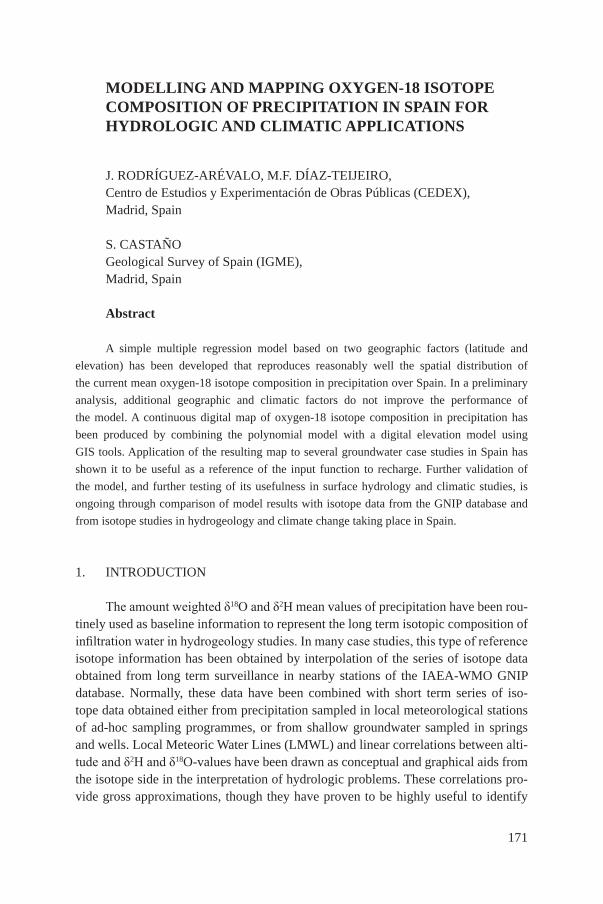
Isotope information in precipitation is scarce in the vicinity of Burgos city, where the origin of groundwater is of concern. δ18o values in groundwater for ter-tiary aquifers in the area for the years 2006 and 2008 compare well with the mod-elled composition of precipitation (fig. 2). annual and interannual means (period 2000–2006) of δ18o-values in precipitation for león, a nearby reVIp station, are also shown in fig. 2 for comparison, and highlight the use of the modelled values as a better reference for the area. one of the limitations of the long term model is its dif-ficulty to simulate temporal variations. Modelling for different periods of time may solve this problem.
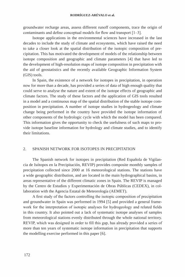
In the tablas de daimiel wetlands, both the origin of surface water and the ex-tent of the trace of evaporated surface water in groundwater are under study. one of the objectives of the studies is to have some water isotope information from the pond water that could be used in correlations with stable isotope data from the sediments in research for climate change. Annual mean (for the period 2000–2006) of δ18o val-ues in precipitation for ciudad real, the closest reVIp station to the area, as well as the isotope composition of surface water in the area sampled at the cigüela ditch are shown in fig. 3. all surface water samples fall in an evaporation line that crosses the global Meteoric Water line in a point that compares well with both the modelled
FIG. 2. Comparison of the δ18O values measured in groundwaters in the city of Burgos against the modelled values in precipitation for the outcropping areas of the geological formations as the potential source of these waters.
03-04
04-05
01-02
05-06
02-03
00-01
-80
-70
-60
-50
-40
-10 -9.5 -9 -8.5 -8 -7.5 -7 -6.5 -6
δ18O (‰)
δ2 H (‰
)
GMWLREVIP-León. Mean 2000-2006REVIP-León. Hydrological yearsIGME-CEDEX Model. Tertiary recharge zoneTertiary springs Jun. '06Tertiary springs Mar. '08Tertiary springs Sep. '08
RodRíguez-ARévAlo et al.
176
isotopic composition of precipitation in the area and the isotopic composition of pre-cipitation from the closest reVIp station.
6. conclusIons: lIMItatIons of tHe regressIon Model and future deVelopMents
The results obtained so far show a good fit between modelled stable isotope values and those measured in surface and groundwaters from different aquifers and recharge areas. the model seems to provide integrated isotope values for precipi-tation in areas where direct sampling in meteorological stations is lacking, to trace the sources of water in peninsular spain. the gIs tools applied to a continuous digi-tal layer of spatial isotope are able to provide accurate information at detailed scales that are not affordable by other means.
These promising results, obtained when the global model was modified to take into account the circumstances of the local scale in this region, are due to the rath-er simple climatic situation of the country in which the atlantic ocean is the main source of water vapour and westerly winds are predominant over the Iberian penin-sula in the long term.
notwithstanding this, future developments, aimed at further testing the model, are proceeding in order to compare the results of the model with a larger data set of isotope information combining: (1) more recent data from the spanish network for isotopes in precipitation (reVIp) not yet included in the model; (2) data from the gnIp database for neighbouring countries; (3) isotope data of groundwaters from different sites in spain covering a wider set of geographic and climatic situations; (4)
FIG. 3. Comparison of the δ18O values measured in surface waters in Daimiel National Park against the modelled values in precipitation in the area.
y = 4.60x - 15.55
-70
-60
-50
-40
-30
-20
-10
0
-10 -9 -8 -7 -6 -5 -4 -3 -2 -1 0
δ18O (‰)
δ2 H (‰
)
Cigüela ditch
REVIP-Ciudad Real. 2000-06 Mean
IGME-CEDEX Model at Tablas N.P.
GMWL
Lineal (Cigüela ditch)
IAEA-CN-186/214
177
isotope information from the spanish network for isotopes in rivers initiated in 2009; and (5) isotope data of leaky reservoirs.
the validity of the modelling strategy has to be tested case by case before it is applied at the local scale, as far as it depends on the climate and hydrogeological situation of the region under study. favourable factors for the applicability of these models are the existence of a single or a main source of water vapour for precipi-tation, and a traceable trajectory of the fronts producing precipitation. finally, it is important to perform a rigorous comparison between modelled and observed isotope composition of precipitation and other components of the hydrologic cycle in order to test the model and to assess its limitations.
REFERENCEs
[1] InternatIonal atoMIc energy agency, stable Isotope Hydrology: deu-terium and oxygen-18 in the Water cycle, technical report series no. 210, Iaea, Vienna (1981).
[2] InternatIonal atoMIc energy agency, guidebook on nuclear tech-niques in Hydrology, technical report series no. 91, Iaea, Vienna (1968).
[3] clarK, I., frItZ, p., environmental Isotopes in Hydrogeology, lewis publishers, Boca raton, florida (1997).
[4] BoWen, g.J., WIlKInson, B.H., Spatial distribution of δ18o in meteoric precipi-tation, geology 30 4 (2002) 315–318.
[5] plata, a., Composición isotópica de las precipitaciones y aguas subterráneas de la península Ibérica, Monografías, cedeX, Madrid (1994) (in spanish).
[6] díaZ-teIJeIro, M.f., rodrígueZ-aréValo, J., castaño, s., la red es-pañola de Vigilancia de Isótopos en la precipitación (reVIp): distribución isotópica espacial y aportación al conocimiento del ciclo hidrológico, Ingeniería civil 155 (2009) 87–97 (in spanish).
[7] díaZ-teIJeIro, M.f., rodrígueZ-aréValo, J., péreZ, J.e., castaño, s., araguás, l. “factors controlling the stable isotopic composition of recent precipi-tation in spain”, proc. Int. symposium advances in Isotope Hydrology and its role in sustainable Water resources Management (IHs–2007), Vol. 1. Iaea, Vienna (2007) 239–249.
[8] rodrígueZ-aréValo, J., castaño, s., díaZ-teIJeIro, M.f., Marcos, l.a., VáZQueZ-MarroQuín, M., Modelo de distribución espacial continua de δ18o en la precipitación en la provincia de Burgos, desarrollo de la metodología y aplicación en hidrología, geogaceta 43 (2007) 79–82 (in spanish).
EnvironmentProgramme
Isotopes in Hydrology, Marine Ecosystems and Climate Change Studies
Proceedings of an International Symposium, Monaco, 27 March –1 April 2011
Isotopes in Hydrology, Marine Ecosystem
s and Climate Change Studies
Atoms for Peace
Atoms for Peace
Atoms for Peace
Atoms for Peace
InternatIonal atomIc energy agencyVIenna
ISBN 978–92–0–135610–9ISSN 0074–1884
Vol. 1
The International Symposium on Isotope Hydrology, Marine Ecosystems and Climate Change Studies was held from 27 March to 1 April 2011 in Monaco, to commemorate the fiftieth anniversary of the establishment of the IAEA laboratory in the Principality of Monaco. The symposium was jointly organized by the IAEA Water Resources Programme and the IAEA Environment Laboratories. The event also represented the thirteenth edition of the quadrennial Symposium on isotope hydrology and water resources management, which has been regularly organized by the IAEA since 1963. The technical sessions covered aspects related to the use and application of isotope tools in a broad spectrum of scientific disciplines through invited talks, oral and poster presentations and workshops. The five technical sessions covered the following topics: (a) the role of isotopes in understanding and modelling climate change, marine ecosystems and water cycles (b) carbon dioxide sequestration and related aspects of the carbon cycle (c) isotopes and radionuclides in the marine environment, (d) groundwater assessments of large aquifers and (e) analytical methods and instrumentation. These proceedings contain the presentations made at the symposium.
Vol. 1
Proceedings COVER Monaco 2011 VOL 1.indd 1,3 7/16/2013 9:25:28 AM