Embed Size (px)
DESCRIPTION
Landscape Architecture Portfolio / AYAKA H. MATTHEWS / West Virginia University / MLA
Citation preview
AYAKA H. MATTHEWS2013 PORTFOLIO
L A N DS
CA
PE
AR
CH
I T E C T U R E


AYAKA H
. M
ATT
H E W S
TIMELINEEDUCATION
2002
2005
2007
2006
2009
2008
20
11
20
12
20
13
20
10WORK EXPERIENCE
AWARD & HONOR
We
st V
irg
inia
Un
ivers
ity,
We
st V
irig
inia
MLA
Pro
gra
m (
GPA
:4.0
)R
ese
arc
h A
ssis
tan
tsh
ip a
t W
est
Vir
gin
ia U
niv
ers
ity
Kyo
to U
niv
ers
ity,
Ja
pa
n
Ma
ster’
s d
eg
ree
in
Ag
ricult
ura
l Scie
nce
s (G
PA:3
.8)
Gif
u U
niv
ers
ity,
Ja
pa
n B
ach
elo
r’s
de
gre
e in
Ag
ricult
ure
(G
PA:3
.6)
Inte
rnsh
ip e
xp
eri
en
ce in
th
e c
ity p
lan
nin
g d
ep
art
me
nt
at
Om
iha
ch
ima
n c
ity in
Ja
pa
n
Kit
ai S
ekk
ei C
om
pa
ny ,L
td a
s A
ssis
tan
t En
gin
eer
20
08
1st
Pri
ze, C
ou
rtya
rd D
esi
gn
Co
mp
eti
tio
n o
f K
yoto
Un
ivers
ity
Win
ner
of
the
juve
nile
lite
ratu
re s
ecti
on
of
the
Bun
ge
isya
-
Vis
ua
l Art
Co
mp
eti
tio
n
20
08
1st
Pri
ze, t
he
C
LA L
and
sca
pe
De
sig
n S
tud
en
t C
om
peti
tio
n
Re
ceiv
ed
full
sch
ola
rsh
ip e
xem
pti
on
fro
m J
AS
SO
Stu
de
nt
Sch
ola
rsh
ip P
rog
ram
Meri
tori
ou
s S
tud
en
t Tu
itio
n W
aiv
er
in M
LA p
rog
ram
in
WV
U
CONTENTS
01 Ecological Planning & Design
02 Brownfield Development
03 Sustainable Energy Park Development
04 Historic Preservation andTourism Enhancement
05 Other Skills
The result of TWINSPAN
The result of classification of shrine woods by TWINSPAN and occurrence of bird species in each group.
The result of the multiple liner regression analysis shows that the area of a shrine, the number of the tree species in a shrine, and the ratio of the canopy area in 100 m circle are chosen as factors are decisive to the number of bird species in a shrine forest. It means that shrines with many tree species, a larger area, and many trees around are more attractive for many bird species.
TWINSPAN divided 15 bird species into four bird communities by the frequency of their existence in each shrine woods. It also divided 42 shrines into four groups which have similar bird communities. It shows that shrine group A and B are less biodivese than that of gourp C and D. Most bird species of 25 target species were seen in shrine group D.
The result of the multiple liner regression analysis
Factors RegressionCoefficient
Adjusted Rf2 = 0.72, AIC = 100.1, DW = 1.62
Area of the Shrine
The number of theTree species in the shrine
The ratio of the Canopy area in 100m Circle
Distance from Makino River
Constant
Standard PartialRegressionCoefficient
Partial Correlation Coefficient
StandardError P-Value VIF
2.07 0.455 0.508 0.676 0.005 1.417
0.677 0.217 0.283 0.441 0.137 1.283
0.069 0.327 0.417 0.029 0.024 1.213
0.069 0.236 0.287 0.044 0.131 1.481
-4.578
A B C D
2.4 4.5 9.0 10.3The Average Number of Bird Species
Bird Community #1
Bird Community #2
Bird Community #3
Bird Community #4
The Shrine Groups The name of Bird Bird Communities The Number of Shrines 8 23 3 8
92 95 73 13 0 30 12 2 0 33 18 29 0 7 0 0 5 20 70 8836 30 19 38 9 0 0 6 4 1 12 26 3 5 0 28 0 6 13 43 0 2 32 63 0 2 19 51 0 0 24 17 0 0 7 40 0 0 0 38
Passer montanus Corvus macrorhynchosStreptopelia orientalisSturnus cineraceusHypsipetes amaurotisCorvus macrorhynchosLanius bucephalusEophona personataCettia diphoneCarduelis sinkiZosterops japonicusParus majorAegithalos caudatusParus variousDendrocopos kizuki
Frequency of Bird Species in each Shrine Group ( % )The environmental factors related to the birds divesity
Avg. number of the Tree species: 7 + 8.2
Avg. of the Areas: Unmeasurable(Belong to Mt.Yoro)
_Avg. ratio of the Canopy area in 100m Circle : more than 50%
Shrine Group D
_
_Avg. number of the Tree species: 18 + 3.5
Avg. of the Areas: 2,515 + 115 m2
Avg. ratio of the Canopy area in 100m Circle : more than 50%
Shrine Group C Shrine Group A
_
_
_
Avg. number of the Tree species: 10.1 + 3.4
Avg. of the Areas: 1,075 + 550
The Average ratio of the Canopy area in 100m Circle : 6.9 + 5.5 %
Shrine Group B
_
_Avg. of the Areas: 2,159 + 625
Avg. number of the Tree species: 14.8 + 5.3
_Avg. ratio of the Canopy area in 100m Circle : 10.2 + 8.7 %
+PURPOSE
+METHOD
+RESULT
Dendrocopos kizuki
Zosterops japonicusEophona personata
Hypsipetes amaurotis Sturnus cineraceus Streptopelia orientalis Corvus macrorhynchos Lanius bucephalus
Corvus macrorhynchos Passer montanus
Carduelis sinkiCettia diphone
Aegithalos caudatusParus majorParus various
DES IGN A PLACE FOR HUMAN AND WILDL IFE
1. A bird survey, a vegetation survey, and a land-use survey were conducted on 42 shrine woods in a 35km2 area in a rural part area of Gifu-prefecture, in the middle of Japan.
2. Collected the data of 11 environmental factors that might influence birds’ existence at shrines forests.
3. The relationship between avifauna and environmental factors was clarified by a multiple linear regression analysis, TINSPAN, and a discriminate analysis.
A Japanese shrine, one of the most important cores of Japanese communities as the place for religious, cultural, and community activities, is also an important place for supporting local ecosystems. They usually have woods surrounding the god’s sacred building in the center. The woods provide native species with habitats and ecological corridors for traveling.
The purpose of this thesis is to analyze the relationships between the vegetation and avifauna in each shrine woods, and find environmental factors related to the difference of their biodiversity. The result will provide us with the key points for designing green spaces for both human and wildlife.
01 ECOLOGICAL PLANNING & DESIGN
The result of classification of shrine woods by TWINSPAN and occurrence of bird species in each group.
Area Vegetation Green Linkage
2.4 4.5 9.0 10.3
8 23 3 8
Shrine Group A
Avg. of the Areas: 1,075 + 550
Diospyros kaki Thunb.Myrica rubra Lour.Cerasus jamasakura H.Ohba.
Magnolia quinquepetaMagnolia kobusRutaceae Juss.Camellia japonicaCamellia sasanqua Thunb.Acer palmatum Thunb.
Ficus carica LAralia elataZanthoxylum piperitum(L.) DC.
Vitis coignetiae Pulliat ex Planch.Helianthus annuus L.
Zelkova serrataAphananthe aspera Planch.Celtis sinensis Pers.var. japonica Nakai.Cinnamomum camphora (L.) J.PreslCryptomeria japonica D.DonIlex rotundaPersera thunbergii Kosterm.Styrax japonica Siebold & Zucc.
Cleyera japonica Thunb.Eurya japonicaPhotinia glabra Franch. & Sav.
Aucuba japonicaDamnacanthus indicusSarcandra glabraArdisia crenata Sims
Mar Apr May June July Aug Sep Oct Nov Dec Jan Feb
The Blooming Season The Fruite Season
Planting Materials for Human
Planting Materials for wildlife
Canopy Layer
Canopy Layer
Understory
Understory
Shrub Layer
Shrub Layer
Others
+CONCLUSION & KEYS FOR IMPROVING GREEN SPACE FOR B IRD’S HABITATS
+A DESIGN MODEL OF GREEN SPACE FOR HUMAN AND WILDL IFE
Green Linkage
Community Gathering Space
Birds Gathering Space
Gre
en
Lin
kag
e
Enhance Green Linkage between Habitats
Create a Place Shared by People and Birds
Publishment :
“The Relationship Between Avifauna and Environmental Factors of Shrine Woods in Rural Areas”- Journal of the Japanese Society of Revegetation Technology 35(4), 523-531, 2010-05
A A’
RECREATION
WATERPLAY
GATHER
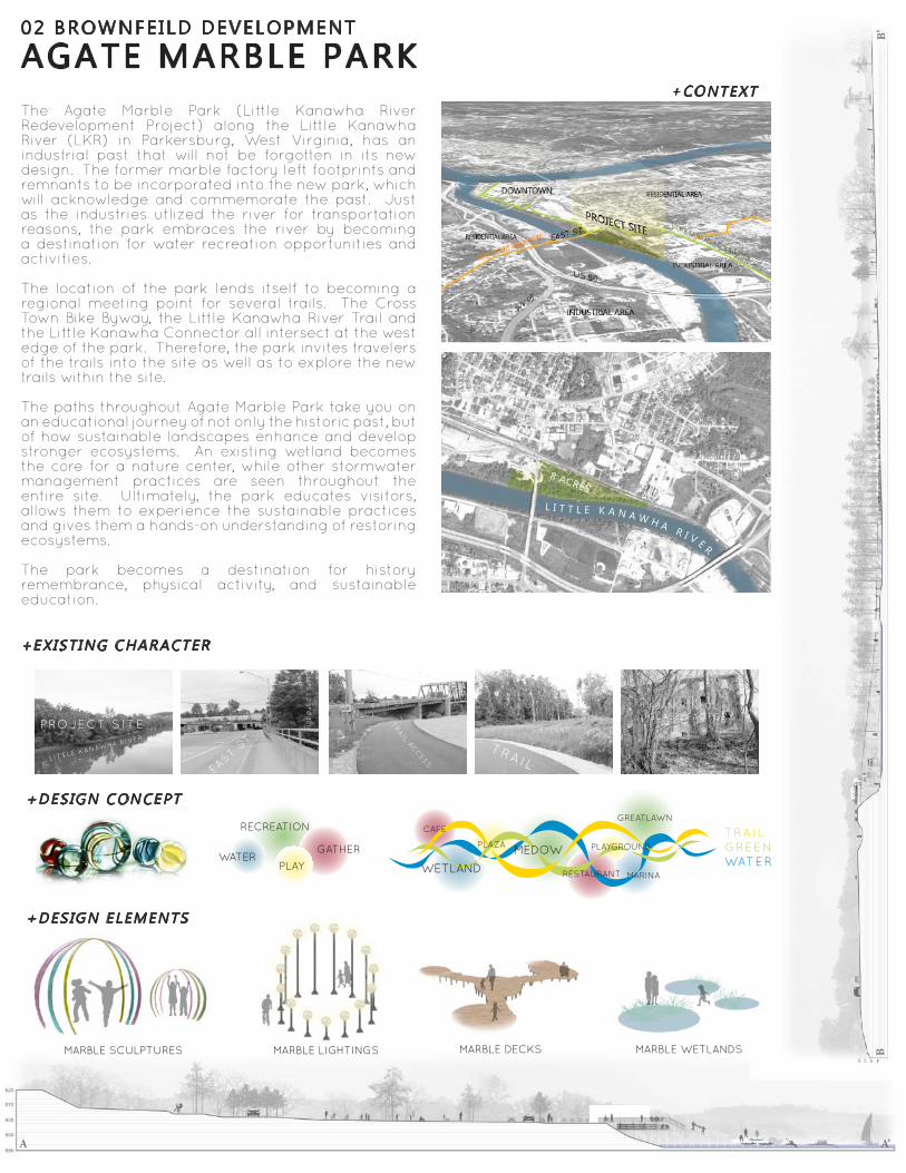
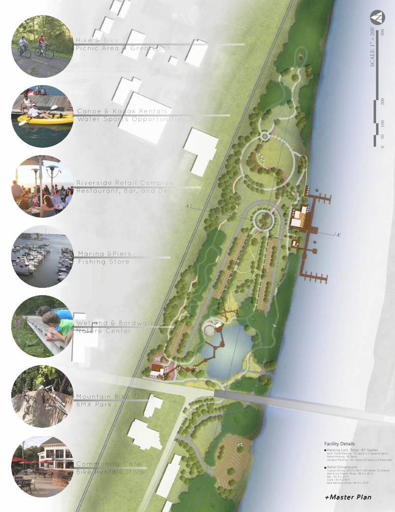
02 BROWNFEILD DEVELOPMENT
+CONTEXT
+EXIST ING CHARACTER
+DESIGN CONCEPT
+DESIGN ELEMENTS
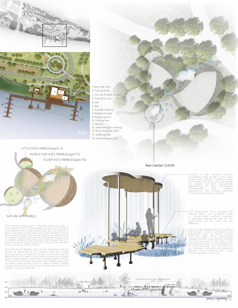
AGATE MARBLE PARKThe Agate Marble Park (Little Kanawha River Redevelopment Project) along the Little Kanawha River (LKR) in Parkersburg, West Virginia, has an industrial past that will not be forgotten in its new design. The former marble factory left footprints and remnants to be incorporated into the new park, which will acknowledge and commemorate the past. Just as the industries utlized the river for transportation reasons, the park embraces the river by becoming a destination for water recreation opportunities and activities.
The location of the park lends itself to becoming a regional meeting point for several trails. The Cross Town Bike Byway, the Little Kanawha River Trail and the Little Kanawha Connector all intersect at the west edge of the park. Therefore, the park invites travelers of the trails into the site as well as to explore the new trails within the site.
The paths throughout Agate Marble Park take you on an educational journey of not only the historic past, but of how sustainable landscapes enhance and develop stronger ecosystems. An existing wetland becomes the core for a nature center, while other stormwater management practices are seen throughout the entire site. Ultimately, the park educates visitors, allows them to experience the sustainable practices and gives them a hands-on understanding of restoring ecosystems.
The park becomes a destination for history remembrance, physical activity, and sustainable education.
PROJECT SITE PR
OJ
EC
T S
ITE
EAST ST
TRA
IL ACC
ESS
TRAIL
EAST ST
WETLAND
ABANDONED GLASS FACTORYRAILROAD
LITTLE KANAWHA RIVER
TRAILGREENWATER
CAFE
RESTAURANT MARINA
GREATLAWN
WETLAND
MEDOWPLAZA PLAYGROUND
BB’
MARBLE SCULPTURES MARBLE LIGHTINGS MARBLE DECKS MARBLE WETLANDS
L I T T L E K A N A W H A R I V E R
8 ACRES
AB
A’
B’
A’
Hike & Bike TrailsP icnic Area & GreatLawn
Canoe & Ka yak Renta lsWater Sports Opportunit ies
Rivers ide Retail Compl exRestaurant , Bar, and Del i
Marina &PiersFishing Store
Wetland & BordwalksNature Center
Mountain Bike TrailsBMX Park
Community CafeBike Renta l&Store
050
100
200
500
SCA
LE: 1
” = 2
00’
N
+Master P lan
Facility DetailsParking Lots Total : 87 Spots)Boat TrailerParking : 10 Spots + 2 General SpotsRetail Parking : 15 Spots General Parking : 60 Spots (15 Spots x 4 Parkings)
Retail Dimensions Casual Dining : 30 ft x 40 ft (18 tables, 72 chairs)Deli & Ice Cream Shop : 30 ft x 20 ftBar : 30 ft x 20 ftCafe : 30 ft x 15 ftBike Rental & Store : 40 ft x 20 ft
Bikers Friendly Bench
Perspective View
9
10
11
13
14
12
C
C’
1
23 5
6
6
7
8
4
Pers
pect
ive V
iew
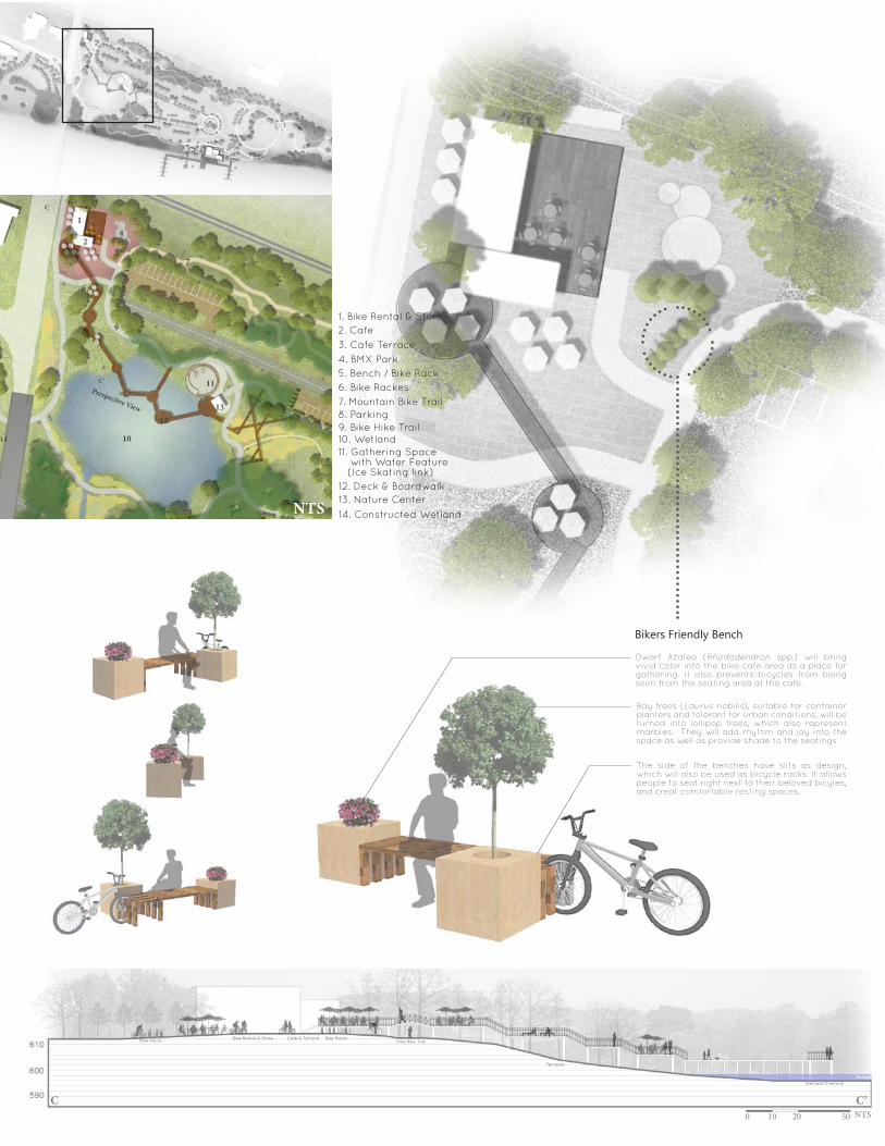
1. Bike Rental & Store2. Cafe
4. BMX Park
7. Mountain Bike Trail
3. Cafe Terrace
6. Bike Rackes5. Bench / Bike Rack
8. Parking9. Bike Hike Trail10. Wetland
12. Deck & Boardwalk
11. Gathering Space with Water Feature (Ice Skating link)
14. Constructed Wetland
13. Nature Center
Wetland
Bike Racks
Wetland Overlook
Bike Rental & Store Cafe & Terrace
Terraces
Bike RacksHike Bike Trail
0 10 20 50 NTS
NTS
Dwarf Azalea (Rhododendron spp.) will bring vivid color into the bike cafe area as a place for gathering. It also prevents bicycles from being seen from the seating area at the cafe.
Bay trees (Laurus nobilis), suitable for container planters and tolerant for urban conditions, will be turned into lollipop trees, which also represent marbles. They will add rhythm and joy into the space as well as provide shade to the seatings.
The side of the benches have slits as design, which will also be used as bicycle racks. It allows people to seat right next to their beloved bicyles, and creat comfortable resting spaces.
C C’
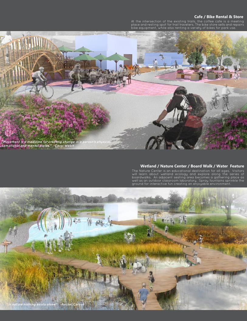
Cafe / Bike Rental & StoreAt the intersection of the existing trails, the coffee cafe is a meeting place and resting spot for trail travelers. The bike store sells and repairs bike equipment, while also renting a variety of bikes for park use.
“Movement is a medicine for creating change in a person’s physical, emotional and mental states.” -Carol Welch
“In nature nothing exists alone” -Rachel Carson
NTS
Wetland / Nature Center / Board Walk / Water FeatureThe Nature Center is an educational destination for all ages. Visitors will learn about wetland ecology and explore along the series of boardwalks. An adjacent seating area becomes a gathering place as well as an outdoor classroom laboratory. Spray fountains sprinkle the ground for interactive fun creating an enjoyable environment.
D’
1
2
1212
3
5
67
91011
11
13
15
148
4
D
NTS
1. Bike Hike Trail
9. Kayak Launch
2. Fishing Store
10. Fishing Pier
4. Casual Dining
12. Water Pilings ( History)
7. Outside Seating
15. Nature Playground
3. Service Road & Access
11. Marina
6. Bar
14. Walking Path
5. Deli
13. River Overlook Deck
8. Kayak Storage
0 10 20 50 NTS
Marina Marina
River OverlookPier Pier Pier
Fishing Store
Kayak Launch
Casual Dining / Bar / Deli / Kayak Rental
Kayak Storage
D D’
Rain Catcher: CLOUD
LITTLE KIDS MARBLE(age0-2)
MIDDLE AGE KIDS MARBLE(age3-5)
OLDER KIDS MARBLE(age6-15)
Perspective View
Perspective View
NATURE ART MARBLE
CLOUD, a rain catcher, collects stormwater and brings it into each constructed wetland marbles area. It provides not only roof and shade for people, but also educational opportunity to learn stormwater management and wetland ecosystems. The unique look-alike clouds will be loved by children.
The Boardwalks flow through the Nature Park with different sizes of constructed wetland marbles. It provides seating as well as the opportunity to be close to the wetlands.
Constructed Wetland Marbles reduce stormwater runoff, sediments and pollutants such as heavy metals from the water. Each constructed wetland marble has different wildlife and species due to the size of the wetland, locations, microclimate such as sunshine, heat, soil, wind and so on. Children shall learn bio-diversity through these marbles, and it will inspire childrens’ creativity.
The Nature Playground / Marble shooting area is composed of four marble shape spaces with different sizes depending on age groups and uses. This design is able to provide comfortable and joyful spaces to each age group for play. Each marble space is connected by a linkage of paths, boardwalks, and green spaces, and it creates gradual flow between each space. Each of them has decks or benches, which allows their parents to sit and watch their children.
The Nature Art Marble has natural materials such as stones or branches for art creation and also round paving stones for playing marbles. Little kids’ marble area which is for age 0-2, is a small closed comfortable space where parents and their children spend time as if they were at home. The other two marble areas are for more vigorous activities for older children. Slides, swings, tree houses, and all of the play equipment are made of natural materials.
“Fun is good.” -Dr. Seuss
All holidays can be good times. -John Clayton
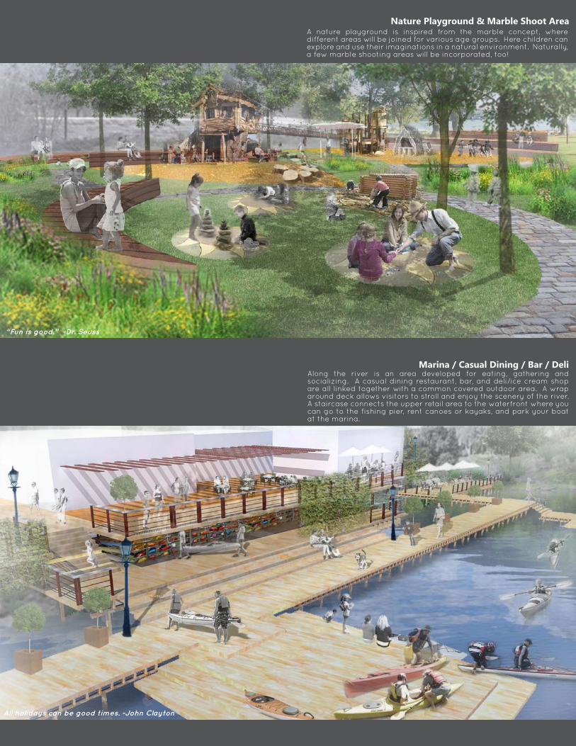
Nature Playground & Marble Shoot AreaA nature playground is inspired from the marble concept, where different areas will be joined for various age groups. Here children can explore and use their imaginations in a natural environment. Naturally, a few marble shooting areas will be incorporated, too!
Marina / Casual Dining / Bar / Deli Along the river is an area developed for eating, gathering and socializing. A casual dining restaurant, bar, and deli/ice cream shop are all linked together with a common covered outdoor area. A wrap around deck allows visitors to stroll and enjoy the scenery of the river. A staircase connects the upper retail area to the waterfront where you can go to the fishing pier, rent canoes or kayaks, and park your boat at the marina.
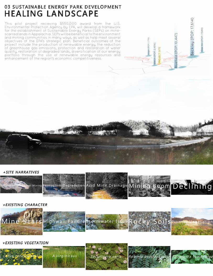
HEAL ING LANDSCAPE03 SUSTAINABLE ENERGY PARK DEVELOPMENT
+SITE NARRATIVES
+EXIST ING VEGETATION
Mine Scars
Ac id ic , Low fe r t i l e , and Dry a reas P ioneer t ree spec ies
Lotus corn icu la tus A .v i rg in icaus Secur igera var ia Robin ia pseudoacac ia Pau lownia tomentosa
Ac id Mine Dra inage Min ing Boom Dec l in ingMounta intop Remova l Min ing Ecosys tem Degradat ion
H ighwal l Fa i lu re Stormwater I s sueRocky So i l s Pioneer Vegetat ion
+EXIST ING CHARACTER
This pilot project recieving $550,000 award from the U.S. Environmental Protection Agency by EPA, will develop a framework for the establishment of Sustainable Energy Parks (SEPs) on mine-scarred lands in Appalachia. SEPs will be beneficial to the environment and mining communities in many ways, as well as help meet several objectives of the EPA’s strategic plan. Beneficial outcomes of the project include the production of renewable energy, the reduction of greenhouse gas emissions, protection and restoration of water quality, restoration of degraded lands, diversification of our energy portfolio through the use of renewable energy resources and enhancement of the region’s economic competitiveness.
Be
ckl
ey (
PO
P: 1
7,6
14)
Blu
efi
eld
(PO
P: 1
0,4
47)
Log
an
(PO
P: 1
,779
)
30 miles
20 miles
Oa
k H
ill (
PO
P: 7
,58
9)
We
lch
(PO
P: 2
,40
6)
PR
OJEC
T S
ITE
Val ley f i l l a reasNat ive spec ies Pioneer t ree spec ies
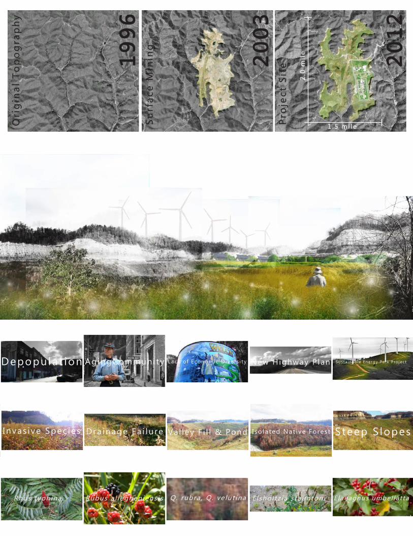
Elsho l tz ia s taunton i i E laeagnus umbel la t taRhus typh ina Rubus a l leghen iens i sPau lownia tomentosa Q. rubra , Q . ve lu t ina
Depopula t ion AgingCommuni ty Lack o f Economic D ivers i ty New Highway P lan Susta inab le Energy Park Pro jec t
I nvas ive Spec ies Dra inage Fa i lu re Val ley F i l l & Pond Steep S lopesIso la ted Nat ive Fores t
19
96
20
03
20
12
2.0
mil
e
1 . 5 mi leSu
rfac
e M
inin
g
Pro
ject
Sit
e
Ori
gin
al T
op
og
rap
hy
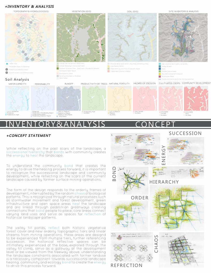
+CONCEPT STATEMENT
+INVENTORY & ANALYSIS TOPOGRAPHY & HYDROLOGY(GIS) SITE INVENTORY & ANALYSIS
CONCEPTINVENTORY&ANALYSIS
VEGETATION (GIS) SOIL (GIS)
Soi l Ana lys i s
SUCCESSION
BO
ND
CH
AO
S
REFRECTION
HIERARCHY
ENER
GY
ORDER
While reflecting on the past scars of the landscape, a successional hierarchy that bonds with community creates the energy to heal the landscape.
To understand the community bond that creates the energy to drive the healing process forward, it is important to recognize the successional landscape and community development, while reflecting on the scars of the current landscape caused by former surface mining operations.
The form of the design responds to the orderly frames of development, interrupted by the random chaos of biological patterns. This is recognized through natural processes such as stormwater movement and forest development. green infrastructure and open space areas heal the landscape and are linked through pedestrian greenways creating connections that bond people to place. core areas connect varying land uses and serve as spaces for reflection of historical landscape patterns.
The valley fill ponds, reflect both historic vegetative forest cover and new orderly topographic tiers and linear streams from mining operations. these areas are designd to be experienced from multiple tiers, further referencing succession. the historical reflective spaces can be intimately experienced at the base, explored through the valley fill climb, serve as a gateway at the development level or be viewed from the freeway above. understanding the landscape constraints associated with former landuse is a necessary component towards successional landscape healing. community and ecology bond to create the energy to drive this process forward.
WATER CAPACITY PERMIRABILITY RUNOFF CULITIVATED CROPS COMMUNITY DEVELOPMENTPRODUCTIVITY OF TREES HAZARD OF EROSIONNATURAL FERTILITY
LimitedUnsuitable
No data
UnsuitableVaryNo data
Moderately HighNo data
Moderateley RapidModerately Rapid or Rapid
Very SevereLow or Moderate
Moderate or HighModerate
ModerateModerate or Moderately Rapid
Slow or Medium
Very Rapid
Medium or RapidRapid or Very Rapid
Low or Medium
No dataNo dataMedium
Water Flow
Runoff Concentration Areas
Runoff Severe Concentration Areas
Preferable Areas for Buildings
Pineville-Berks association, very steep, extremely stony
Gilpin and Lily soils, 15 to 35 percent slopes
Urban land-Chavies complex
Udorthents (100%)
Central Oak-Hardwood & Pine Forest
Central Mesophytic Hardwood Forest
Developed & Urban
Northern & Eastern Pine - Oak Forest, Woodland & Barrens
Developed, Open Space
Open Water
Recently Disturbed or Modified
Wet condition and organic soil profile
Pond
Isolated native forest
Dry and Compacted rocky soil
Stormwater Basin
Swales and berms by former mining operation
Vellay fill area
Elements
Ecosystem Restoration
Circulation
Topographic Barriers
Visual Connections
Stormwater Management
Bioswale
Bioretention Pond
Prison
PrisonVellyfill & Pond
Commercial
Residential
Industorial
Solar Pannels
Proposed Highway
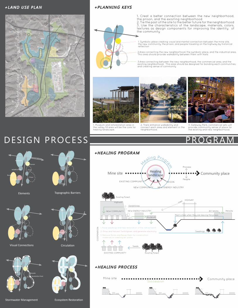
+LAND USE PLAN
DESIGN PROCESS PROGRAM+HEALING PROGRAM
+PLANNING KEYS
+HEALING PROCESS
1. Symbolic place creating visual and mental connection between the mine site, the new community, the prison, and people traveling on the highway by historical reflection
1. Museum and reforestation area in the valley fill area will be the core for healing landscape.
2. Trails enhance walkability and connect each area and element in the neighborhood.
3. Gateway Park, commercial sets will provide community sense of place for the existing and new neighborhood.
2.Area connecting the new neighborhood, the symbolic place, and the industrial area. This area should provide walkability between them with trails
3.Area connecting between the new neighborhood, the commercial area, and the existing neighborhood. This area should be designed for bonding each communities, and creating sense of community
1. Creat a better connection between the new neighborhood, the prison, and the exisiting neighborhood2. Tie the past of the site to the better future for the neighborhood3. Use the characteristics of the landscape, materials, colors, textures as design components for improving the identity of the community
COMMUNITY DEVELOPMENT
Mine siteSuccession
Community place
Mine site Community placeHealinglandscape
Healing Program
PRISONPeople
Process
NEW COMMUNITY NEW ENERGY INDUSTRY
EXISTING COMMUNITY
Plant a tree when they are leaving the prison
Exisitng Forest
Seeds
Seedlings
1. Raise seedlings and help restoration of the native foerst
2. Grow and harvest Switchgrass, and generate electricity
3. Remove Rocks and Reuse them for construction materials or creating art works
EXISTING COMMUNITY
PRISON
HIGHWAY
NEW COMMUNITY
MUSEUM
NEW ENERGY INDUSTRY
Sandstones
Highwall
CO
OPE
RAT
ION
View
Art Works
Exisitng Forest
Ro
ad
Co
mm
erc
ial A
rea
Exi
stin
g R
oad
s
Exi
sitn
gC
om
mun
ityRe
sid
en
tia
l Are
a
Proposed Highway
Trail
Ind
ust
ria
l Are
a
Low Prairie
Biomass Plant
Biomass Plant
Biomass PlantG
ate
wa
y p
ark
pa
rk
pa
rk
Pri
son
Historical Refrection &Community Engagement
His
tori
ca
l Re
fre
cti
on
&C
om
mun
ity E
ng
ag
em
en
t
Valley fill& Ponds
Valley fill& Ponds
Solar Panel
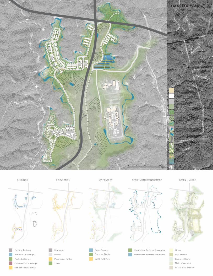
MASTER PLAN
0 100’ N
+MASTER PLAN
BUILDINGS CIRCULATION NEW ENERGY STORMWATER MANAGEMENT GREEN LINKAGE
Low Prairie
Switchgrass
Bioswale
Proposed Highway
Road
Pedestrian Path
Trail
Solar Pannel
Wind Turbine
Existing Buildings
Proposed Buildings
Parking
Forest Restoration Area
Vellyfill and Pond
Bioretention Pond
Existing Builings Highway Solar Panels Vegetation Buffa or Bioswales Grass
Industrial Buildings Roads
Wind turbines
Bioswales& Bioretention Ponds Low Prairie
Public Buildings Pedestrian Paths
Biomass Plants
Biomass Plants
Native SpeciesCommercial Buildings Trails
Residential Buildings Forest Restoration
0 50’ 100’ 200’ NNTS
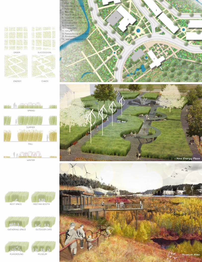
REST SPACE MEETING BOOTH
OUTDOOR CAFE
MUSEUM
ORDER SUCCESSION
CHAOS ENERGY
GATHERING SPACE
PLAYGROUND
SPRING
SUMMER
FALL
WINTER- New Energy Plaza
- Museum Area
MASTER PLAN
0 100’ N
8
4
13
12
7
3
2
2
914
11
6
5
1
10
8. Constructed Wetland
4. Bioswale
13. Boadwalks12. Forest Restoration Area
7. Museum
3. Parking
2. Industorial Building
9. Overlook
14. Wetland Restoration Park
11. Vellyfill
6. Sculpture Garden5. New Energy Plaza
1. Liner Park
10. Crane Path
0 30’ NNTS

MASTER PLAN
0 100’ N
+RESIDENTIAL AREA
16. Gas Station
17. Grocery Store
9. Farmers Market
7. Restaurant&Cafe
8. Retails
6. Recreation Center5. Attached Houses
12. Town Houses
10. Gateway Park
4. Central Park3. Cottage Houses
19. Trail
18. Overlook
2. Community Park
14. Bioretention Pond
15. Bioswale
1. Stormwater Park
11. Hotel
13. Apartment
20. Forest Restoration Area
1
2
2
2
2
2
2
12
12
3
5
6
7
9
10
11
13
15
1617
18
18
19
20
19
18
14
8
4
1
3
CO
MM
UN
ITY
PA
RK
& C
EN
TR
AL
PAR
K
geth
eri
ng
sp
ace
com
mun
ity g
ard
en
pla
ygro
und
STO
RM
WAT
ER
PA
RK
sto
rmw
ate
r m
an
ag
em
en
te
cosy
ste
m R
est
ora
tio
nh
ike
& b
ike
tra
il D
eck
and
bo
rdw
alk
s
CO
MM
ER
CIA
L A
REA
gro
cery
sto
reg
ass
sta
tio
nlo
ca
l reta
il st
ore
sca
fe &
re
sta
ura
nts
GAT
EW
AY
PA
RK
recre
ati
on
&co
mm
un
ity c
en
ter
com
mun
ity g
ard
en
farm
ers
ma
rket
ou
tdo
or
ca
fem
uit
i-u
se s
pa
ceco
nst
ructe
d w
etl
and
wa
ter
fea
ture
pla
ygro
und
SU
STA
INA
BLE
DES
IGN
gre
en
roof
(in
th
e n
ort
h)
sola
r p
an
els
(in
th
e s
ou
th)
win
d t
urb
ine
rain
ba
rre
lst
orm
wa
ter
reu
se
- Trail Connection- Community Park
0 50’ NNTS
BIORETENTION PONDBIORETENTION POND BIOSWALEBIOSWALE
+STORMWATER MANAGEMENT +LAYERS
South North
PAR
K S
YS
TEM
GR
EEN
& W
ATE
R L
INK
AG
EC
IRC
ULA
TIO
NBU
ILD
ING
SStormwater shall be treated by the continual set of bioswales and bioretention ponds. This system responding to topography and using natural systems, shall slow the movement of water, allow it to infiltrate, and reduce stormwater, especially from the highwalls into this site. It will also create wetland habitats and the linkage of water and green spaces into the community. Each park connected by this linkage will be important places to bond people and nature.
Because the compaction by mining operations has created an impermeable surface, green roofs will play an important role in managing stormwater that have the ability to reduce total runoff by 60%. Also, the ground would be built up around buildings to keep runoff away from the structures, and move runoff into bioswales and bioretention ponds. This method also creates a healthy soil medium for vegetation development. The area between the rocky highwalls and built environments will be the areas for growing biomass plants and ecosystem restoration, which will ensure the safety of the people.
- Stormwater Park
THURMOND HISTORIC PARK04 HISTORIC PRESERVATION & TOURISM ENHANCEMENT
Thurmond is a town on the New River in Fayette County in southern West Virginia. It was established in 1873 right after the Chesapeake and Ohio Railway came into this region for the coal industry ,and It used to be one of the most flourishing towns as the center of commercial and railroad connections within the New River area during the 1880s - 1950s. While the population,which used to be 400, has decreased to 5 since the coal industry started declining, the National Park Service had a restoration project and restored the depot of the town and some commercial buildings to preserve and tell the history of this unique town. The goal of this project is to propose a renovation plan of the site as a pocket park for recreation, and also as a
PROJECT S ITE
PROJECT S ITE
0 .45 acres
NNTS
NNTS
THURMOND HISTORIC PARK
1. Create a good connection from the depot and commercial buildings to the park as a series of history telling paths2. Allow visitors to experience, feel, and learn the history of Thurmond through design elements of Thurmond such as the railroad, coal, and the abandoned buildings 3.Create a transition of the spaces from the public space to the community space towards the town hall4. Design the space as a place for creating a sense of community5. Install Raingardens for Stormwater management
+Des ign ob jec t i ves
PROJECT S ITE
New
R iverC
oaling Tower
Residential Area
Gravel Paths
Thurmond D
epot
Town H
all
Com
mercial
Buildings
Com
munity Space
Public Space
Historic
Element
Historic
Element
Historic
Element
River View
0 10’ 20’ 30’ 50’ NNTS
Connect ion
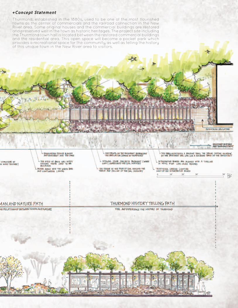
Thurmond, established in the 1880s, used to be one of the most flourished towns as the center of commercials and the railroad connection in the New River area. Some original houses and the commercial buildings are restored and preserved well in the town as historic heritages. The project site including the Thurmond town hall is located between the restored commercial buildings and the residential area. This open space will become a pocket park which provides a recreational space for the community, as well as telling the history of this unique town in the New River area to visitors.
+Concept S ta tement
0 10’ 20’ 30’ 50’ NNTS
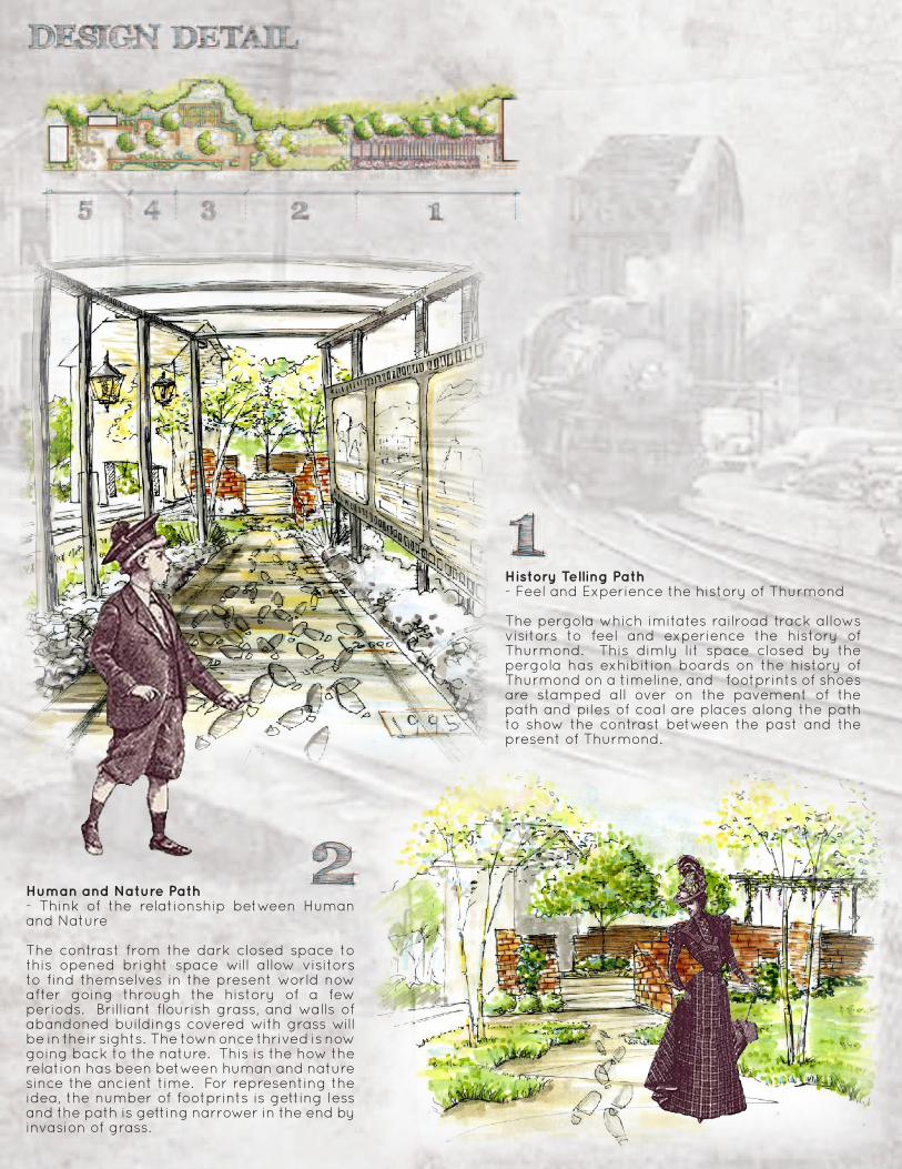
History Telling Path- Feel and Experience the history of Thurmond
The pergola which imitates railroad track allows visitors to feel and experience the history of Thurmond. This dimly‐lit space closed by the pergola has exhibition boards on the history of Thurmond on a timeline, and footprints of shoes are stamped all over on the pavement of the path and piles of coal are places along the path to show the contrast between the past and the present of Thurmond.
Human and Nature Path:- Think of the relationship between Human and Nature
The contrast from the dark closed space to this opened bright space will allow visitors to find themselves in the present world now after going through the history of a few periods. Brilliant flourish grass, and walls of abandoned buildings covered with grass will be in their sights. The town once thrived is now going back to the nature. This is the how the relation has been between human and nature since the ancient time. For representing the idea, the number of footprints is getting less and the path is getting narrower in the end by invasion of grass.
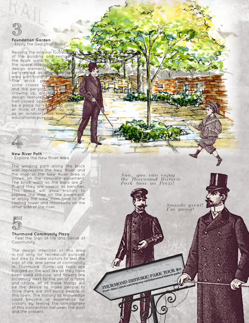
Foundation Garden:- Enjoy the Design of Ruins
Reusing the original foundation of the building and restoring the brick walls to 4’ – 5’ tall, the space integrated with the design elements of ruins will be created as a unique rest area with historic atmosphere. The brick pavement with some crakes with vegetation and the pergola with wisteria crowing up, are some of the design features of ruins. This half-closed opened space will be a place for visitors to relax or think of the past, as well as an outdoor class room for educational purpose.
New River Path:- Explore the New River Area
The winding path along the brick wall represents the New River, and the map of the New River area is shown on the concrete pavement. The brick walls on the back are 2’-3’ and they are usable as benches. This space will allow visitors to explore the map on the pavement, or enjoy the view from here to the coaling tower and mountains on the other side of the river.
Now, you can enjoy the Thurmond Historic Park tour on Prezi!
Sounds great!I'm going!
Thurmond Community Plaza:- Feel the Sign of life and Sense of Community
The design intention of this area is not only for recreation purpose but also to make visitors to feel the sign of life, and sense of community in Thurmond. Some old tools are hanged on the wall like as they have been used still now, and flowers are blooming next to the set of a table and chairs. All of these things will be the device to make people to think there are still some people in this town. The history as knowledge could become an experience for visitors by feeling the atmosphere of this connection between the past and the present.
2%
4%
2%
2%
HP 629
HP 626.7
TC 622.0BC 621.5
2%
2%
2%
4%
4%
4%
2%
624
626
628
628
626
626
628
624
622
620
TW 631.5BW 630.0
TW 629.5BW 628.0
TW 630.5BW 629.0
TW 629.5BW 628.0
TW 631.0BW 629.5
TW 629.0BW 627.5
TW 629.5BW 628.0
625.9
624.2
622.1
TC 623.17BC 622.67
TC 622.0BC 621.5
624.7624.7
622.6622.6
Elevation:616
BC:615
BC:616
BC:616.5
BC:615
PRO
DU
CED
BY
AN
AU
TOD
ESK
ED
UC
ATI
ON
AL
PRO
DU
CT
PRODUCED BY AN AUTODESK EDUCATIONAL PRODUCT
PRO
DU
CED
BY A
N A
UTO
DESK
EDU
CA
TION
AL PR
OD
UC
T
PRODUCED BY AN AUTODESK EDUCATIONAL PRODUCT
3H:1V SIDE SLOPE MAX,TYP
6"-12' TYPPONDING DEPTH
BEEHIVE RIM
B2-3" MULCH NATIVE PLANTS PER LANDSCAPE ARCHITECT/DESIGNER
BEAM AS NEEDED
INSTALL LINER ABOVE RIM EL
COMPACTED STRUCTURAL FILL
EXISTING GRADE
WOOS STAKE
RIM EL = XXX.XX
12" -
28" CRUSHED GRAVEL
COARSE SAND
UNIFORMLY GRADEDSTORAGE ROCK
UNDISTURBED NATIVE SUBGRADE
6" PERFORATED HDPE PIPES = 0.0000
MIN SUMP DEPTH
IE OUT = XXX.XX
COMPACTED NATIVE SUBGRADE
3" 34" - 0 DRAIN ROCK, OPT
NON - PERFPRATED OVERFLOWPIPE DIRECTED TO APPROVEDDISPOSAL POINT
AREA DRAIN
AMENDED PLANTING SOIL
IMPERMEABLE LINER
EXCAVATE AT STABLESLOPE ANGLE FOR NATIVE SOIL
WIDTH (5' MIN)
18"
2"
18" M
IN
SE
PE
RA
TIO
N/F
ILTE
RR
OC
K L
AY
ER
3"3"
12"
PRO
DU
CED
BY
AN
AU
TOD
ESK
ED
UC
ATI
ON
AL
PRO
DU
CT
PRODUCED BY AN AUTODESK EDUCATIONAL PRODUCT
PRO
DU
CED
BY A
N A
UTO
DESK
EDU
CA
TION
AL PR
OD
UC
TPRODUCED BY AN AUTODESK EDUCATIONAL PRODUCT
Concrete wheel stops to hold backvehicles while allowing runoff to
pass under and through
Depth of basin can vary with width, and withthe anticipated inflow quantity, but side
slopes should not exceed 10 - 15 %
Minimum 2 % slope intobioretention basin
Amended topsoil
Geotextile fabric optional
6" perforated drain tile, bedded in graveland min.36" deep; or below frost line
Mixed planting of flood tolerant trees,shrubs, and / or perennial groundcover
PRO
DU
CED
BY
AN
AU
TOD
ESK
ED
UC
ATI
ON
AL
PRO
DU
CT
PRODUCED BY AN AUTODESK EDUCATIONAL PRODUCT
PRO
DU
CED
BY A
N A
UTO
DESK
EDU
CA
TION
AL PR
OD
UC
T
PRODUCED BY AN AUTODESK EDUCATIONAL PRODUCT
(b)
WALK PATTERN OPTIONAL
ROWLOCK COURSE
STRETCHER COURSE
SLOPE 1/4"
1" - 2"OF SAND
PRO
DU
CED
BY
AN
AU
TOD
ESK
ED
UC
ATI
ON
AL
PRO
DU
CT
PRODUCED BY AN AUTODESK EDUCATIONAL PRODUCT
PRO
DU
CED
BY A
N A
UTO
DESK
EDU
CA
TION
AL PR
OD
UC
T
PRODUCED BY AN AUTODESK EDUCATIONAL PRODUCT
05 OTHER SK ILLS
+AutoCAD
+SketchUp
SPAIN
STORMWATER PARK
OUTDOOR CAFE&KICHHEN
GREEN PARKING
BIOSWALES
RAINGARDENS
BRICK STAIRS
FRANCE ITALY NEW ZEALAND
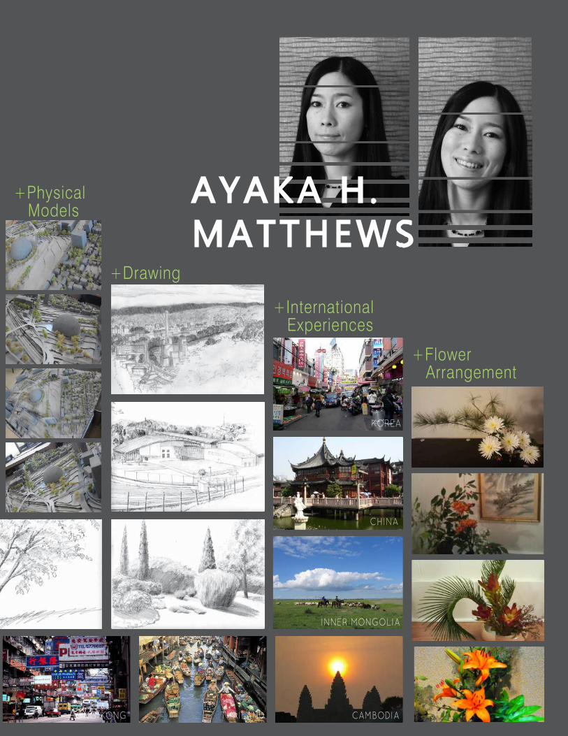
+Drawing
+Physical Models
+Flower Arrangement
+International Experiences
AYAKA H .MATTHEWS
NEW ZEALAND HONG KONG THAILAND CAMBODIA
INNER MONGOLIA
CHINA
KOREA