Embed Size (px)
Citation preview
8/7/2019 laserace_sec
http://slidepdf.com/reader/full/laseracesec 1/2
Uses & Functions✴ Distance to Targets
✴ Bearing and Elevationto Targets
✴ Heights of Large Objects
✴ Widths Between Targets✴ Slopes and Gradients
✴ Areas and Volumes
✴ X,Y & Z Coordinates
✴ Perimeter Distances
Applications✴ Surveying
✴ Stockpile Measurements
✴ Agricultural Areas✴ Cross Sections
✴ Forestry Management
✴ Accident Surveys
✴ Cable Clearances/Heights
✴ GPS Offsets
✴ Hydrographic Surveying
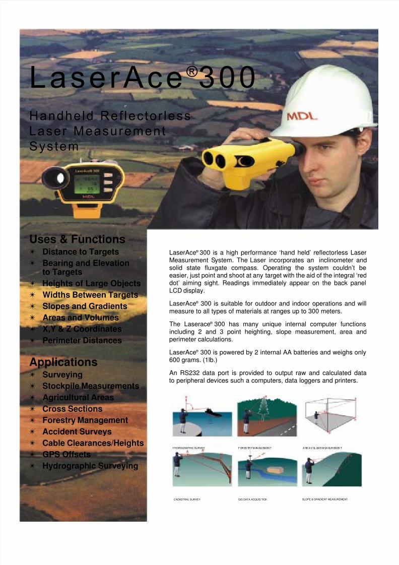
LaserAce ®300Handheld Ref lector less
Laser Measurement
System
LaserAce® 300 is a high performance ‘hand held’ reflectorless LaserMeasurement System. The Laser incorporates an inclinometer andsolid state fluxgate compass. Operating the system couldn’t beeasier, just point and shoot at any target with the aid of the integral ‘reddot’ aiming sight. Readings immediately appear on the back panelLCD display.
LaserAce® 300 is suitable for outdoor and indoor operations and willmeasure to all types of materials at ranges up to 300 meters.
The Laserace® 300 has many unique internal computer functionsincluding 2 and 3 point heighting, slope measurement, area andperimeter calculations.
LaserAce® 300 is powered by 2 internal AA batteries and weighs only600 grams. (1lb.)
An RS232 data port is provided to output raw and calculated datato peripheral devices such a computers, data loggers and printers.
HYDROGRAPHIC SURVEY
CADASTRAL SURVEY GIS DATA ACQUISITION SLOPE & GRADIENT MEASUREMENT
F OR ES TR Y M AN AG EM EN T A RE A V OL UM E M EA SUR EM ENT

8/7/2019 laserace_sec
http://slidepdf.com/reader/full/laseracesec 2/2
DESCRIPTION PART No
LaserAce® 300 laser inclinometer 5000
LaserAce® Compass 5010
Data Cable 5035
Soft Carry Bag 5040
Manual 5060
*System can be provided without the compass where 2D measurements only are required
Information contained herein is believed to be accurate. However, no responsibility is assumed by MDLfor its use.
Technical information is subject to change without no tice.
Tel: UK +44 (0)1224 246700 Tel: USA +1 281 646 0050email: [email protected] www.laserace.com
Agents Stamp
BURDENACE® - ROCK PROFILER
LASERACE® ENCODER
LASERACE® TS 300 - TOTALSTATION
LASERACE® ACCESSORIES
LaserAce® FamilyLASER
Type GaAs Laser Diode 905nm
Eye Safe Class 1 CENELEC EN60825-1/FDA
Range Passive up to 300m. Reflectors to 5km
Range Accuracy Typically 10cm
Range Resolution 1cmMeasurement Time 0.3 sec
INCLINOMETER
Type Accelerometer
Range -90º to + 90º
Accuracy 0.3º at 0º
Resolution 0.1º
COMPASS
Type Digital 3 Axis Fluxgate
Range 0º to 360º
Accuracy Typically better than 1ºResolution 0.1º
Construction Reinforced Polycarbonate
Weight 50g
TECHNICAL DATA
Construction Reinforced Polycarbonate
Dimensions (L x W x H) 175 x 106.5 x 56mm
Data I/O RS232 4800 or 9600 Baud
Power 3V DC 350mA (Standby 20mA) / 2 x AA cells internally
Weight 600g
Custom LCD Display Backlit
Alignment Telescope Red Dot Scope / optional telescope
ENVIRONMENTAL
Operating Temperature -10º to + 45ºC
Water & Dust Resistant IP65
SYSTEM COMPRISES
TECHNICAL SPECIFICATIONS
Certification No. Q 50061Designers and Manufacturers
FORESTACE® 300 - TREE MANAGEMENT


