Embed Size (px)
Citation preview
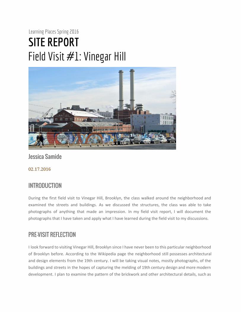
Learning Places Spring 2016
SITE REPORT Field Visit #1: Vinegar Hill
Jessica Samide
02.17.2016
INTRODUCTION
During the first field visit to Vinegar Hill, Brooklyn, the class walked around the neighborhood and
examined the streets and buildings. As we discussed the structures, the class was able to take
photographs of anything that made an impression. In my field visit report, I will document the
photographs that I have taken and apply what I have learned during the field visit to my discussions.
PRE-VISIT REFLECTION
I look forward to visiting Vinegar Hill, Brooklyn since I have never been to this particular neighborhood
of Brooklyn before. According to the Wikipedia page the neighborhood still possesses architectural
and design elements from the 19th century. I will be taking visual notes, mostly photographs, of the
buildings and streets in the hopes of capturing the melding of 19th century design and more modern
development. I plan to examine the pattern of the brickwork and other architectural details, such as
the width and material of the structural bays above the windows, which indicate the date of the
building. I expect that there will be plenty of 1950s design influences in some of the buildings due to
urban renewal.
SITE DOCUMENTATION (photos/sketches)
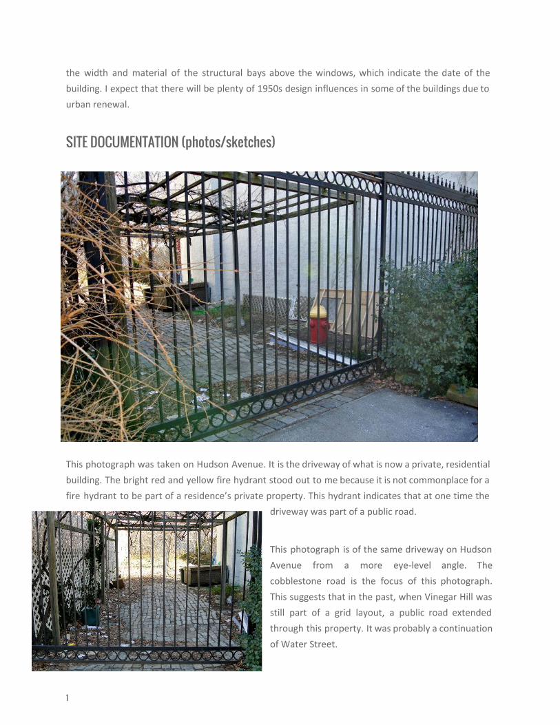
This photograph was taken on Hudson Avenue. It is the driveway of what is now a private, residential
building. The bright red and yellow fire hydrant stood out to me because it is not commonplace for a
fire hydrant to be part of a residence’s private property. This hydrant indicates that at one time the
driveway was part of a public road.
This photograph is of the same driveway on Hudson
Avenue from a more eye‐level angle. The
cobblestone road is the focus of this photograph.
This suggests that in the past, when Vinegar Hill was
still part of a grid layout, a public road extended
through this property. It was probably a continuation
of Water Street.
1
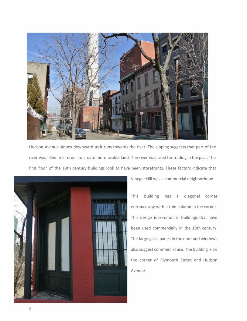
Hudson Avenue slopes downward as it runs towards the river. The sloping suggests that part of the
river was filled in in order to create more usable land. The river was used for trading in the past. The
first floor of the 19th century buildings look to have been storefronts. These factors indicate that
Vinegar Hill was a commercial neighborhood.
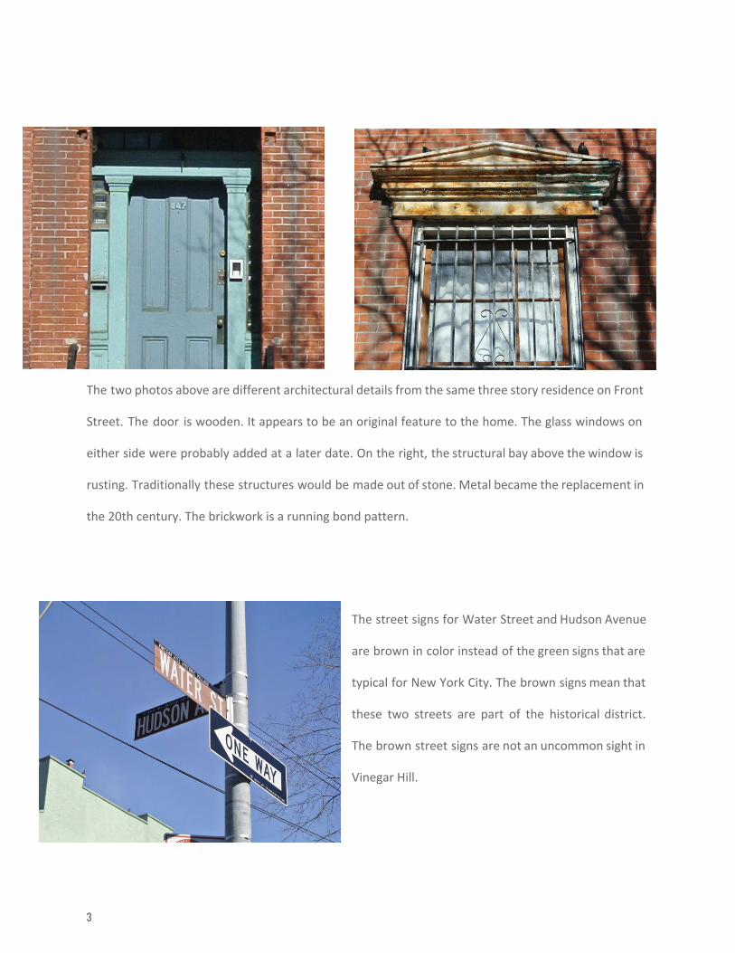
This building has a diagonal corner
entranceway with a thin column in the corner.
This design is common in buildings that have
been used commercially in the 19th century.
The large glass panes in the door and windows
also suggest commercial use. The building is on
the corner of Plymouth Street and Hudson
Avenue.
2
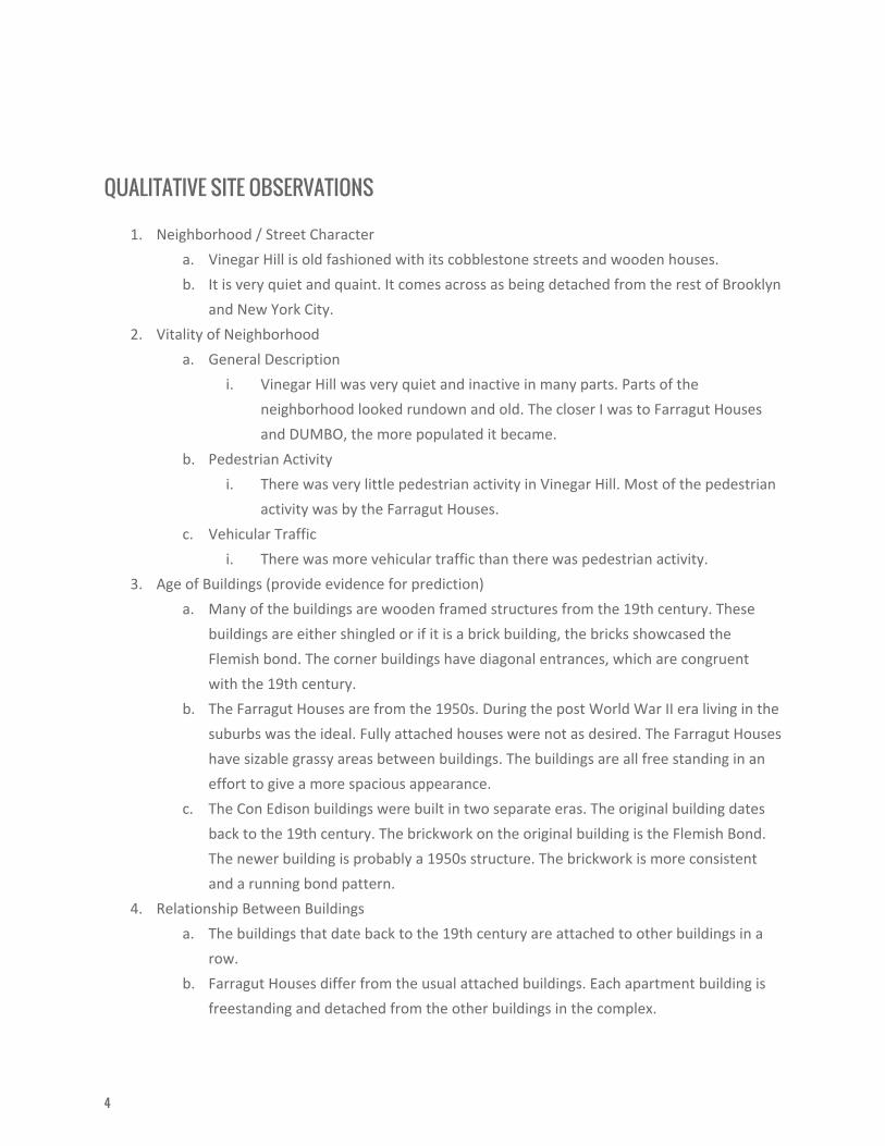
The two photos above are different architectural details from the same three story residence on Front
Street. The door is wooden. It appears to be an original feature to the home. The glass windows on
either side were probably added at a later date. On the right, the structural bay above the window is
rusting. Traditionally these structures would be made out of stone. Metal became the replacement in
the 20th century. The brickwork is a running bond pattern.
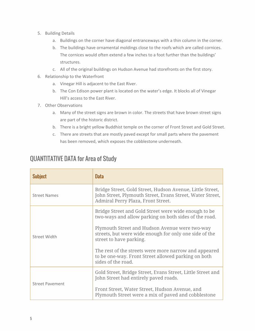
The street signs for Water Street and Hudson Avenue
are brown in color instead of the green signs that are
typical for New York City. The brown signs mean that
these two streets are part of the historical district.
The brown street signs are not an uncommon sight in
Vinegar Hill.
3
QUALITATIVE SITE OBSERVATIONS
1. Neighborhood / Street Character
a. Vinegar Hill is old fashioned with its cobblestone streets and wooden houses.
b. It is very quiet and quaint. It comes across as being detached from the rest of Brooklyn
and New York City.
2. Vitality of Neighborhood
a. General Description
i. Vinegar Hill was very quiet and inactive in many parts. Parts of the
neighborhood looked rundown and old. The closer I was to Farragut Houses
and DUMBO, the more populated it became.
b. Pedestrian Activity
i. There was very little pedestrian activity in Vinegar Hill. Most of the pedestrian
activity was by the Farragut Houses.
c. Vehicular Traffic
i. There was more vehicular traffic than there was pedestrian activity.
3. Age of Buildings (provide evidence for prediction)
a. Many of the buildings are wooden framed structures from the 19th century. These
buildings are either shingled or if it is a brick building, the bricks showcased the
Flemish bond. The corner buildings have diagonal entrances, which are congruent
with the 19th century.
b. The Farragut Houses are from the 1950s. During the post World War II era living in the
suburbs was the ideal. Fully attached houses were not as desired. The Farragut Houses
have sizable grassy areas between buildings. The buildings are all free standing in an
effort to give a more spacious appearance.
c. The Con Edison buildings were built in two separate eras. The original building dates
back to the 19th century. The brickwork on the original building is the Flemish Bond.
The newer building is probably a 1950s structure. The brickwork is more consistent
and a running bond pattern.
4. Relationship Between Buildings
a. The buildings that date back to the 19th century are attached to other buildings in a
row.
b. Farragut Houses differ from the usual attached buildings. Each apartment building is
freestanding and detached from the other buildings in the complex.
4
5. Building Details
a. Buildings on the corner have diagonal entranceways with a thin column in the corner.
b. The buildings have ornamental moldings close to the roofs which are called cornices.
The cornices would often extend a few inches to a foot further than the buildings’
structures.
c. All of the original buildings on Hudson Avenue had storefronts on the first story.
6. Relationship to the Waterfront
a. Vinegar Hill is adjacent to the East River.
b. The Con Edison power plant is located on the water’s edge. It blocks all of Vinegar
Hill’s access to the East River.
7. Other Observations
a. Many of the street signs are brown in color. The streets that have brown street signs
are part of the historic district.
b. There is a bright yellow Buddhist temple on the corner of Front Street and Gold Street.
c. There are streets that are mostly paved except for small parts where the pavement
has been removed, which exposes the cobblestone underneath.
QUANTITATIVE DATA for Area of Study
Subject Data
Street Names Bridge Street, Gold Street, Hudson Avenue, Little Street, John Street, Plymouth Street, Evans Street, Water Street, Admiral Perry Plaza, Front Street.
Street Width
Bridge Street and Gold Street were wide enough to be two-ways and allow parking on both sides of the road. Plymouth Street and Hudson Avenue were two-way streets, but were wide enough for only one side of the street to have parking. The rest of the streets were more narrow and appeared to be one-way. Front Street allowed parking on both sides of the road.
Street Pavement
Gold Street, Bridge Street, Evans Street, Little Street and John Street had entirely paved roads. Front Street, Water Street, Hudson Avenue, and Plymouth Street were a mix of paved and cobblestone
5
roads.
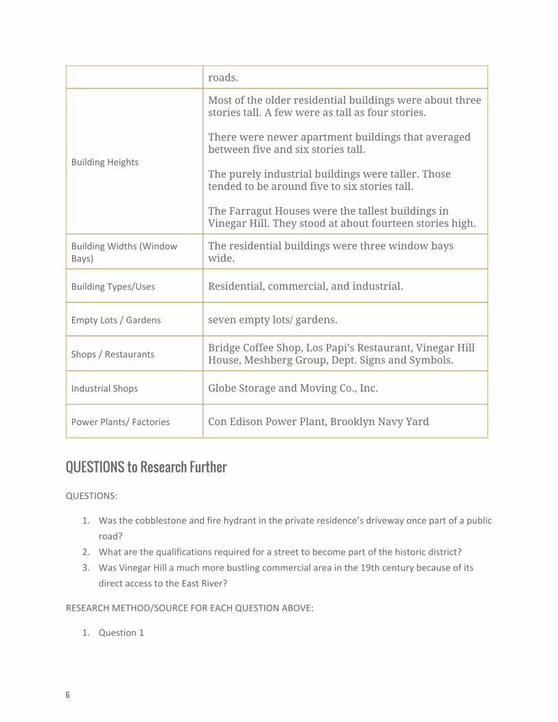
Building Heights
Most of the older residential buildings were about three stories tall. A few were as tall as four stories. There were newer apartment buildings that averaged between five and six stories tall. The purely industrial buildings were taller. Those tended to be around five to six stories tall. The Farragut Houses were the tallest buildings in Vinegar Hill. They stood at about fourteen stories high.
Building Widths (Window Bays)
The residential buildings were three window bays wide.
Building Types/Uses Residential, commercial, and industrial.
Empty Lots / Gardens seven empty lots/ gardens.
Shops / Restaurants Bridge Coffee Shop, Los Papi’s Restaurant, Vinegar Hill House, Meshberg Group, Dept. Signs and Symbols.
Industrial Shops Globe Storage and Moving Co., Inc.
Power Plants/ Factories Con Edison Power Plant, Brooklyn Navy Yard
QUESTIONS to Research Further
QUESTIONS:
1. Was the cobblestone and fire hydrant in the private residence’s driveway once part of a public
road?
2. What are the qualifications required for a street to become part of the historic district?
3. Was Vinegar Hill a much more bustling commercial area in the 19th century because of its
direct access to the East River?
RESEARCH METHOD/SOURCE FOR EACH QUESTION ABOVE:
1. Question 1
6
a. Look for old maps of Brooklyn using online encyclopedias and other online sources.
b. Check out Brooklyn by name how the neighborhoods, streets, parks, bridges, and
more got their names from the City Tech Library for more information on the streets
of Vinegar Hill.
c. Look for information and maps of Vinegar Hill streets while visiting the Brooklyn
Historical Society.
2. Question 2
a. Utilize nyc.gov to look at the Historical Distict Maps.
b. Look up more information on the New York City Landmarks Preservation Commision.
c. Read through the New York City Landmarks Preservation Commission's reports that
are specific to Brooklyn.
3. Question 3
a. Use the Brooklyn Historical Society for access to their library and exhibits on the
history of Brooklyn and the East River.
b. Research online for articles that describe the history of Vinegar Hill in the 19th
century.
c. Examine maps of Vinegar Hill from the 19th century to see the development around
the East River.
SUMMARY / POST VISIT REFLECTION
At first glance Vinegar Hill might not seem like a very desirable neighborhood in which to live, but
upon closer examination it is an area rich in history. The original 19th century buildings still provide
architectural details that act as clues to give us ideas on how the neighborhood once was. The
buildings that are now mostly used for solely residential purposes were at one time shops. The East
River was at one time accessible to pedestrians. I liked that Vinegar Hill seemed tucked away from the
rest of Brooklyn. The quiet atmosphere was beneficial to observing the neighborhood. One of the
observations that made a great impression on me was the existence of street signs that classify parts
of Vinegar Hill as a historic district.
7