Embed Size (px)
Citation preview
September 2015
Environmental Impact Statement
Appendices M-O
Volume 2E
M4 East
M4
East
Appendices
M ����������������������������������������������������������������������������������������������������� Social impact assessment
N ����������������������������������������������������������������������������������������������� Economic impact assessment
O��������������������������������������������������������������������������������������� Soil and water quality assessment
Volume 2E

Appendix MSocial impact assessment

WestConnex Delivery Authority
WestConnex M4 East
Social Impact Assessment
September 2015
Prepared for
WestConnex Delivery Authority
Prepared by
AECOM Australia Pty Ltd
GHD Pty Ltd
© WestConnex Delivery Authority
The concepts and information contained in this document are the property of WestConnex Delivery Authority. You must not reproduce any part of this document without the prior written approval of WestConnex Delivery Authority.
Document controls Title WestConnex M4 East
Social Impact Assessment Social Impact
Assessment
Approval and authorisation Prepared by: Anne Mithieux Authorised by AECOM Australia Pty Ltd:
Jay Stricker Industry Director – Transport
Signed:
Date 5 September 2015
Location File name AECOM Project Folder WCX M4 East_FinalSIA_V1 Rev3.docx
Document status Date Final for exhibition 5 September 2015
WestConnex M4 East i WestConnex Delivery Authority Social Impact Assessment
Contents Glossary of abbreviations ........................................................................................................................iii
1 Introduction ................................................................................................................... 1
1.1 Overview of the project ................................................................................................. 1
1.2 Project location .............................................................................................................. 1
1.3 Secretary’s environmental assessment requirements .................................................. 4
1.4 Purpose of this report .................................................................................................... 5
1.5 Study Area .................................................................................................................... 5
2 Proposed project ........................................................................................................... 9
2.1 Project features ............................................................................................................. 9
2.2 Construction activities ................................................................................................. 10
2.3 Specific aspects relevant to social impact assessment .............................................. 14
3 Assessment methodology ........................................................................................... 22
3.1 Methodology ................................................................................................................ 22
3.2 Impact assessment framework and rating .................................................................. 22
3.3 Key assumptions ......................................................................................................... 24
4 Social policy context.................................................................................................... 25
4.1 Introduction ................................................................................................................. 25
4.2 A Plan for Growing Sydney ......................................................................................... 25
4.3 NSW 2021: A Plan to Make NSW Number One ......................................................... 25
4.4 State Infrastructure Strategy ....................................................................................... 26
4.5 NSW Long Term Transport Master Plan..................................................................... 26
4.6 Draft Parramatta Road Urban Transformation Program ............................................. 26
4.7 Council community strategic plans ............................................................................. 27
5 Description of the existing community ........................................................................ 33
5.1 Regional study area community profile ....................................................................... 33
5.2 Local study area – precinct profiles ............................................................................ 34
5.3 Social infrastructure .................................................................................................... 49
5.4 Access and Connectivity ............................................................................................. 57
5.5 Community values and issues .................................................................................... 60
6 Assessment of construction impacts ........................................................................... 66
6.1 Overview of social assessment of construction impacts ............................................. 66
6.2 Property and household impacts ................................................................................ 66
6.3 Social infrastructure .................................................................................................... 76
6.4 Access and connectivity .............................................................................................. 82
6.5 Amenity ....................................................................................................................... 85
6.6 Business and economic impacts ................................................................................. 87
7 Assessment of operational impacts ............................................................................ 89
7.1 Property and household impacts ................................................................................ 89
7.2 Social infrastructure .................................................................................................... 89
7.3 Access and connectivity .............................................................................................. 90
7.4 Amenity ....................................................................................................................... 92
7.5 Business and economic impacts ................................................................................. 93
8 Cumulative impacts ..................................................................................................... 95
WestConnex M4 East ii WestConnex Delivery Authority Social Impact Assessment
9 Management of impacts .............................................................................................. 96
9.1 Pre-construction and ongoing stakeholder engagement ............................................ 96
9.2 Construction ................................................................................................................ 96
9.3 Operation .................................................................................................................... 98
10 References ................................................................................................................ 100
Appendix A Case studies of social impact assessments for similar projects ...................................A
Appendix B Demographic indicators ................................................................................................B
Appendix C Social infrastructure list ................................................................................................ C
Appendix D Council consultations ................................................................................................... D
Appendix E Consultation with social infrastructure providers ..........................................................E
Appendix F Project land requirements ............................................................................................. F
WestConnex M4 East iii WestConnex Delivery Authority Social Impact Assessment
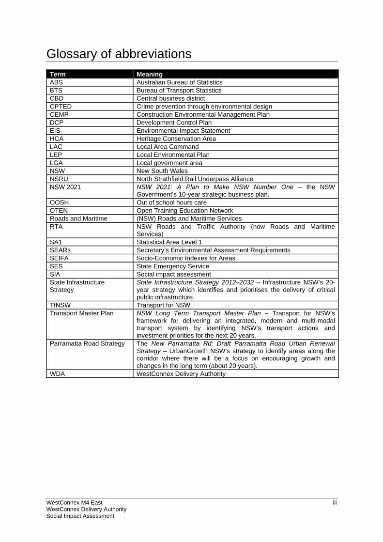
Glossary of abbreviations
Term Meaning ABS Australian Bureau of Statistics BTS Bureau of Transport Statistics CBD Central business district CPTED Crime prevention through environmental design CEMP Construction Environmental Management Plan DCP Development Control Plan EIS Environmental Impact Statement HCA Heritage Conservation Area LAC Local Area Command LEP Local Environmental Plan LGA Local government area NSW New South Wales NSRU North Strathfield Rail Underpass Alliance NSW 2021 NSW 2021: A Plan to Make NSW Number One – the NSW
Government’s 10-year strategic business plan. OOSH Out of school hours care OTEN Open Training Education Network Roads and Maritime (NSW) Roads and Maritime Services RTA NSW Roads and Traffic Authority (now Roads and Maritime
Services) SA1 Statistical Area Level 1 SEARs Secretary’s Environmental Assessment Requirements SEIFA Socio-Economic Indexes for Areas SES State Emergency Service SIA Social impact assessment State Infrastructure Strategy
State Infrastructure Strategy 2012–2032 – Infrastructure NSW’s 20-year strategy which identifies and prioritises the delivery of critical public infrastructure.
TfNSW Transport for NSW Transport Master Plan NSW Long Term Transport Master Plan – Transport for NSW’s
framework for delivering an integrated, modern and multi-modal transport system by identifying NSW’s transport actions and investment priorities for the next 20 years.
Parramatta Road Strategy The New Parramatta Rd: Draft Parramatta Road Urban Renewal Strategy – UrbanGrowth NSW’s strategy to identify areas along the corridor where there will be a focus on encouraging growth and changes in the long term (about 20 years).
WDA WestConnex Delivery Authority

WestConnex M4 East iv WestConnex Delivery Authority Social Impact Assessment
(blank page)
WestConnex M4 East i WestConnex Delivery Authority Social Impact Assessment
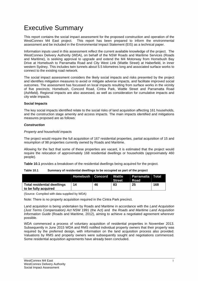
Executive Summary This report contains the social impact assessment for the proposed construction and operation of the WestConnex M4 East project. This report has been prepared to inform the environmental assessment and be included in the Environmental Impact Statement (EIS) as a technical paper.
Information inputs used in this assessment reflect the current available knowledge of the project. The WestConnex Delivery Authority (WDA), on behalf of the NSW Roads and Maritime Services (Roads and Maritime), is seeking approval to upgrade and extend the M4 Motorway from Homebush Bay Drive at Homebush to Parramatta Road and City West Link (Wattle Street) at Haberfield, in inner western Sydney. This includes twin tunnels about 5.5 kilometres long and associated surface works to connect to the existing road network.
The social impact assessment considers the likely social impacts and risks presented by the project and identifies mitigation measures to avoid or mitigate adverse impacts, and facilitate improved social outcomes. The assessment has focussed on local impacts resulting from surface works in the vicinity of five precincts; Homebush, Concord Road, Cintra Park, Wattle Street and Parramatta Road (Ashfield). Regional impacts are also assessed, as well as consideration for cumulative impacts and city wide impacts.
Social Impacts
The key social impacts identified relate to the social risks of land acquisition affecting 161 households, and the construction stage amenity and access impacts. The main impacts identified and mitigations measures proposed are as follows:
Construction
Property and household impacts
The project would require the full acquisition of 167 residential properties, partial acquisition of 15 and resumption of 98 properties currently owned by Roads and Maritime.
Allowing for the fact that some of these properties are vacant, it is estimated that the project would require the relocation of approximately 168 residential dwellings or households (approximately 460 people).
Table 10.1 provides a breakdown of the residential dwellings being acquired for the project.
Table 10.1 Summary of residential dwellings to be occupied as part of the project
Homebush Concord Wattle Street
Parramatta Road
Total
Total residential dwellings to be fully acquired
14 46 83 25 168
(Source: Compiled with data supplied by WDA)
Note: There is no property acquisition required in the Cintra Park precinct.
Land acquisition is being undertaken by Roads and Maritime in accordance with the Land Acquisition (Just Terms Compensation) Act NSW 1991 (the Act) and the Roads and Maritime Land Acquisition Information Guide (Roads and Maritime, 2012), aiming to achieve a negotiated agreement wherever possible.
WDA commenced a process of voluntary acquisition of residential properties in November 2013. Subsequently in June 2015 WDA and RMS notified individual property owners that their property was required by the preferred design, with information on the land acquisition process also provided. Valuations by RMS and property owners were subsequently sought and negotiations commenced. Some residential acquisition agreements have already been concluded.
WestConnex M4 East ii WestConnex Delivery Authority Social Impact Assessment
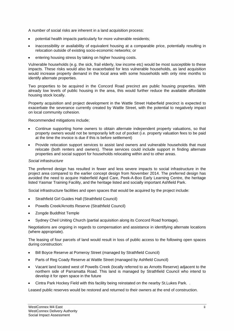
A number of social risks are inherent in a land acquisition process:
potential health impacts particularly for more vulnerable residents;
inaccessibility or availability of equivalent housing at a comparable price, potentially resulting in relocation outside of existing socio-economic networks; or
entering housing stress by taking on higher housing costs.
Vulnerable households (e.g. the sick, frail elderly, low income etc) would be most susceptible to these impacts. These risks would also be exacerbated for less vulnerable households, as land acquisition would increase property demand in the local area with some households with only nine months to identify alternate properties.
Two properties to be acquired in the Concord Road precinct are public housing properties. With already low levels of public housing in the area, this would further reduce the available affordable housing stock locally.
Property acquisition and project development in the Wattle Street Haberfield precinct is expected to exacerbate the severance currently created by Wattle Street, with the potential to negatively impact on local community cohesion.
Recommended mitigations include;
Continue supporting home owners to obtain alternate independent property valuations, so that property owners would not be temporarily left out of pocket (i.e. property valuation fees to be paid at the time the invoice is due if this is before settlement)
Provide relocation support services to assist land owners and vulnerable households that must relocate (both renters and owners). These services could include support in finding alternate properties and social support for households relocating within and to other areas.
Social infrastructure
The preferred design has resulted in fewer and less severe impacts to social infrastructure in the project area compared to the earlier concept design from November 2014. The preferred design has avoided the need to acquire Haberfield Aged Care, Peek-A-Boo Early Learning Centre, the heritage listed Yasmar Training Facility, and the heritage listed and socially important Ashfield Park.
Social infrastructure facilities and open spaces that would be acquired by the project include:
Strathfield Girl Guides Hall (Strathfield Council)
Powells Creek/Arnotts Reserve (Strathfield Council)
Zongde Buddhist Temple
Sydney Cheil Uniting Church (partial acquisition along its Concord Road frontage).
Negotiations are ongoing in regards to compensation and assistance in identifying alternate locations (where appropriate).
The leasing of four parcels of land would result in loss of public access to the following open spaces during construction:
Bill Boyce Reserve at Pomeroy Street (managed by Strathfield Council)
Parts of Reg Coady Reserve at Wattle Street (managed by Ashfield Council)
Vacant land located west of Powells Creek (locally referred to as Arnotts Reserve) adjacent to the northern side of Parramatta Road. This land is managed by Strathfield Council who intend to develop it for open space in the future
Cintra Park Hockey Field with this facility being reinstated on the nearby St.Lukes Park. .
Leased public reserves would be restored and returned to their owners at the end of construction.
WestConnex M4 East iii WestConnex Delivery Authority Social Impact Assessment
The Cintra Park Hockey Field would be relocated nearby to St Luke’s Park so that the site can be used for a construction compound. This relocation has been addressed in a separate environmental assessment which describes the Cintra Park facility not being decommissioned until the proposed hockey field at St Luke’s Park is constructed and commissioned. This would ensure that a hockey field is available during the hockey season.
A number of other social facilities are in close proximity to project surface works and would likely be affected by construction traffic and amenity impacts (e.g. noise, vibration and visual amenity).
These are;
Our Lady of the Assumption Catholic Church on Underwood Street, Homebush
Arnotts Reserve on Allen Street, Homebush
Concord Oval on Parramatta Road, Concord
Jehovah’s Witness Church on Wattle Street, Haberfield
Willows Private Nursing Home on Orpington Street, Ashfield
Haberfield Aged Car on Parramatta Road, Haberfield
Peek-A-Boo Early Learning Centre on Parramatta Road, Haberfield
Yasmar Training Facility on Parramatta Road, Haberfield.
Consultation in accordance with the project Community Consultation Framework would mitigate these impacts, with specific considerations including;
Consult with Strathfield Council and Strathfield Girl Guides to assist in identifying and accessing temporary premises
Continue to support the Zongde Temple in planning for relocation in the short and long term
Liaise with the property owners and the congregation of users at the Sydney Cheil Uniting Church to provide alternate land for car parking
Consult with users of Concord Oval and St Luke’s Park facilities for development of the construction environmental management plan (CEMP) for the Cintra Park tunnel site
Consult with social infrastructure (specifically aged care and child care facilities) affected by the project in regard to any respite periods (where reasonable and feasible) when the most intrusive construction activities are undertaken during the day.
Access and Connectivity
Major construction works would be primarily accessed from Parramatta Road and the M4. Access to construction ancillary facilities would be located to and from arterial roads to provide the most direct access for heavy vehicles. It is estimated construction traffic would represent only two per cent of total daily traffic on Parramatta Road. The construction workforce is expected to increase the volume of light vehicles on the surrounding road network, generating only minor impacts, except in Underwood Road and Short Street East. Localised detours, temporary traffic signals and construction traffic delays are expected to have minor impacts on motorists.
The existing cycleway along the M4 between Hill Road and Concord Road would be unavailable during construction, with a detour route proposed to the north of the M4 corridor. During construction, traffic delays due to increased waiting times at intersections may potentially impact motorists, bus passengers, cyclists and pedestrians. This may reduce the reliability of buses in making connections to other transport modes.
The short term relocation of the westbound Orpington Street bus stop in the Parramatta Road precinct would increase walking distances for visitors to the Willows Private Nursing Home. The closure of Chandos Street and relocation of the westbound bus stop could reduce accessibility and increase travel distances to public transport for residents in the area. Reduced access to public transport is particularly important, as this area recorded higher levels of relative socio-economic disadvantage and lower vehicle ownership.
WestConnex M4 East iv WestConnex Delivery Authority Social Impact Assessment
Similarly, the relocation of the southbound bus stop on Concord Road, together with large footprint of the proposed interchange, would increase walking distances and potentially discourage people to walk to this bus stop or within the local area across Concord Road.
Pedestrian safety at the Bland Street exit of the Parramatta Road eastern civil site would be considered in developing construction environmental management plans.
Consultation in accordance with the project Community Consultation Framework would provide the opportunity to mitigate these impacts, with specific considerations including;
Consult with key local social infrastructure providers in developing construction traffic management plans, including notification to local emergency services about changes to local road networks, particularly road closures
Relocate Orpington Street bus stop in consultation with the Willows Private Nursing Home to minimise walking distance between the relocated bus stop and the nursing home
Explore options to increase pedestrian and cyclist connectivity along the M4 alignment particularly in the vicinity of Underwood Road and Allen Street to increase opportunities for active lifestyles and contribute to offsetting the amenity impact of the project corridor
Develop a construction car parking strategy that promotes public transport use and minimises impacts on on-street car parking
Consider (in consultation with Haberfield Public School and Ashfield Council) pedestrian safety at the egress point for the Parramatta Road civil site at Bland Street, as part of the traffic management and safety plan.
Amenity
The project has the potential to generate considerable noise, with the greatest impacts generated during site establishment works and roadworks. These activities are generally short term at any point as the works move along the alignment. However, longer duration impacts would be experienced in the vicinity of compound and tunnel excavation/spoil removal sites.
In most cases noise generated by construction traffic would be negligible due to the use of the arterial road network. However for local roads such as Short Street East and Powell Street in Homebush, more maximum noise events may occur which would require more consideration of management during detailed design to minimise and mitigate these impacts.
Most of the project area is already exposed to high noise levels from existing traffic with many properties already experience exceedance of noise limits. With a construction period of approximately three years, management of noise and vibration impacts, especially any outside of standard working hours, would be integral to limiting negative impacts on community well-being.
Visual impacts to residences in the vicinity of the project relate primarily to the removal of existing vegetation and resultant loss of visual amenity for the properties overlooking compounds and work sites. In most cases these impacts have been assessed to be low or low to moderate. However impacts on residences adjacent to the Pomeroy Street construction compound, Underwood Road tunnel and civil site and Concord Road civil and tunnel sites, would experience high visual impacts. Residents in Wattle Street, Walker Avenue, Ramsay Street, Martin Street and Dobroyd Parade would also experience high visual impact due to their proximity to multiple project elements.
The project Human Health Risk Assessment has found the potential for stress and anxiety resulting from reduced amenity during construction. However the assessment notes that these impacts would largely be short term and intermittent and are able to be managed by standard mitigation measures.
Project property acquisition would result in the loss of 66 residential properties of heritage significance in the Concord Road, Wattle and Parramatta Road precincts, with significant impacts on the Powell’s Estate and Haberfield Heritage Conservation Areas and impacts to the historical streetscape of Chandos Street.
Recommended mitigation measures, in addition to those in other specialist reports prepared for the EIS and the Community Consultation Framework, include;
WestConnex M4 East v WestConnex Delivery Authority Social Impact Assessment
For those properties that qualify for operational noise attenuation treatments, bring forward the implementation of noise treatments to the early stages of construction where feasible and reasonable
Supporting beautification of construction compound sites through temporary plantings, decorated hoardings and the like to assist in reducing visual impacts.
Business and economic impacts
Twenty private businesses would be fully acquired for the project prior to commencement of construction, including.
One motel with 50 guest rooms and a restaurant;
Four commercial offices;
Nine automotive sales and services;
One personal services business;
Three homeware sales and services; and
Two retail businesses.
The acquisition of these businesses would result in impacts to the local economy through loss of business turnover and employment. WDA’s consultation with affected businesses indicates that the majority of these businesses intend to relocate their business activities to another site within the region and continue trading.
All businesses located on land to be fully acquired are located adjacent to Parramatta Road, toward the eastern end of the project in the suburbs of Ashfield and Haberfield. Many of these businesses serve a wider catchment area so their relocation will not significantly disadvantage the local community. In addition the affected businesses in this area do not generally provide complementary or supplementary goods or services, therefore the viability of adjacent or surrounding businesses should not be affected.
There is the potential for a boost in the economy due to construction expenditure in the region, with local business benefiting from this expenditure through purchases made by construction businesses and associated workers to build and support the development of the project. Employment opportunities would grow in the region through the potential increase in business customers and through the increase in demand for construction workers. The increase in demand for labour may increase wages in the region, particularly for construction workers, who would be in high demand.
Operation
Property and Household impacts
The project is not expected to have any operational residential property impacts, and would not involve the consolidation, rezoning or redevelopment of residual land. However the existence of residual lands does raise the potential for future social benefits by delivering housing, open space, improved active travel connectivity, public facilities or mixed use developments.
Social infrastructure
Landscaping treatments and noise walls would mitigate amenity impacts for most social infrastructure.
The proposed operational infrastructure at Cintra Park would have only minor impacts for park users as the area to be occupied is relatively limited and the bulk of the site would be rehabilitated, landscaped and returned to Canada Bay Council for use as public open space. The upgraded car park would also be wholly available to sports facility users.
Permanent acquisition of 1,312 square metres of the Reg Coady Reserve would be required for the realignment of Wattle Street, however this is not considered to be a significant impact on the availability of local open space.
WestConnex M4 East vi WestConnex Delivery Authority Social Impact Assessment
Access and Connectivity
The project is expected to enhance local and regional connectivity by reducing vehicle delays along the corridor between Homebush Bay Drive in the west and the City West Link and Parramatta Road in the east. The project would support the introduction of dedicated bus lanes between Burwood and Ashfield. Peak morning travel times on strategic routes are expected to reduce by six to eight minutes, increasing to ten to eighteen minutes after the proposed M4-M5 Link is built. These improvements to connectivity would contribute to overcoming the barrier that Parramatta Road presents to regional use of social infrastructure and social benefits through freeing travel time for social and economic pursuits. However in the medium term, before the construction of the proposed future M4-M5 Link, congestion would increase in some areas, particularly on Parramatta Road east of the project.
Reduced traffic volumes and wait times at intersections would benefit cyclists and pedestrians and provide the opportunity for improved active travel infrastructure with urban renewal.
It is recommended that;
Opportunities for providing improved pedestrian and cyclist connectivity especially in the vicinity of Wentworth Street, Underwood Road and Allen Street, Homebush are explored for project operation
WDA liaise with Transport for NSW in regard to improving pedestrian access in the vicinity of the Concord Road interchange, and specifically the southbound Concord Road bus stop.
Amenity
Road traffic noise impacts during operation would, in 78 per cent of cases, result in minor noise reductions along the M4 and Parramatta Road corridors due to traffic displacement into the new tunnels. These areas include the unmodified M4 (east of the proposed M4 East tunnel portals) and Parramatta Road between Concord Road and Wattle Street.
A minor increase in noise levels (less than 2.0 dB which is generally unnoticeable to the average person) is expected at approximately 18 percent of sensitive receivers.
There are 310 instances (4 percent of receivers) where noticeable noise increases could be experienced, primarily as a result of the acquisition of adjacent properties which had previously acted as noise barriers for these properties or where new road noise sources or traffic volumes increase. These properties are eligible for assessment for at property treatments to mitigate noise impacts. For most properties, including social infrastructure for which lower thresholds of noise are permitted, these treatments could potentially improve internal noise conditions compared to existing conditions. However in these cases, increased outdoor noise levels may result in increased levels of stress at individual properties.
Traffic displacement from the M4 and along sections of Parramatta Road is expected to deliver traffic noise amenity benefits supportive of potential urban renewal opportunities in the corridor.
Visual amenity and heritage impacts would remain, largely due to: loss of vegetation screening, new road infrastructure, closer proximity to new road infrastructure, ancillary operational facilities and the loss of heritage items and changes to streetscapes. Project design and landscaping plans aim to minimise visual intrusion of project elements and respect and respond to the existing and desired character of these areas. These impacts, and the consequent impacts to community cohesion and sense of place, are expected to diminish over time as landscaping treatments mature.
Mitigations in addition to those in other specialist reports prepared for the EIS and the Community Consultation Framework are;
Supporting beautification of operational facilities and spaces through public art and landscaping to assist in reducing visual impacts associated with these facilities
Providing support for local community development activities, such as community events, to assist with restoring and increasing community cohesion.
WestConnex M4 East vii WestConnex Delivery Authority Social Impact Assessment
Business and economic impacts
Businesses located at the eastern and western portals and west of Concord Road are likely to experience reduced amenity due to increased traffic volumes and the introduction of new infrastructure. Businesses located along Parramatta Road, east of Concord Road and not located adjacent to the eastern or western portal, would experience improved amenity due to the reduction in vehicles, particularly heavy vehicles on Parramatta Road.
Businesses on Parramatta Road that are reliant on passing trade would be affected by the project, with an estimated annual reduction of around $7.3 million in output and around 33 full-time equivalent jobs due to loss in passing trade. There is also potential for increases in passing trade for businesses located along Parramatta Road, west of Concord Road, from an increase in traffic volumes. A total of five businesses were identified as potentially benefitting from an increase in passing trade, comprising of services stations, a car wash and cafes/restaurants.
Reduced business operational costs are also expected due to increased accessibility and transport efficiencies for business.
Cumulative impacts
The key cumulative impacts are related to the overlapping constructions periods for other stages of WestConnex (current M4 widening between Church Street, Parramatta and Homebush Bay Drive and the proposed M4-M5 Link). Overlap would result in prolonged exposure of residents, motorists, cyclists, pedestrians and public transport users to construction amenity impacts and travel delays.
During operation, the cumulative impacts are expected to be positive, with the project facilitating the implementation of the Parramatta Road Urban Transport Program by reducing traffic and improving amenity in the Parramatta Road corridor, including the potential for introduction of dedicated bus lanes. Specifically, this would benefit the key urban renewal precincts of Auburn, Homebush, Burwood and Kings Bay and support housing and employment growth in these precincts. Enhanced connectivity and travel efficiencies would benefit both local and regional communities and the business and commercial sectors.

WestConnex M4 East viii WestConnex Delivery Authority Social Impact Assessment
(blank page)
WestConnex M4 East 1 WestConnex Delivery Authority Social Impact Assessment
1 Introduction
1.1 Overview of the project NSW Roads and Maritime Services (Roads and Maritime) is seeking approval to upgrade and extend the M4 Motorway from Homebush Bay Drive at Homebush to Parramatta Road and City West Link (Wattle Street) at Haberfield. This includes twin tunnels about 5.5 kilometres long and associated surface works to connect to the existing road network. These proposed works are described as the M4 East project (the project). The location of the project is shown in Figure 1.1.
Approval is being sought under Part 5.1 of the Environmental Planning and Assessment Act 1979 (NSW) (EP&A Act). The project was declared by the Minister for Planning to be State significant infrastructure and critical State significant infrastructure and an environmental impact statement (EIS) is therefore required.
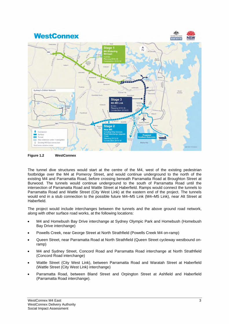
The project is a component of WestConnex, which is a proposal to provide a 33 kilometre motorway linking Sydney’s west and south-west with Sydney Airport and the Port Botany precinct. The location of WestConnex is shown in Figure 1.2. The individual components of WestConnex are:
M4 Widening – Pitt Street at Parramatta to Homebush Bay Drive at Homebush (planning approval granted and under construction)
M4 East (the subject of this report)
New M5 – King Georges Road at Beverly Hills to St Peters (planning application lodged and subject to planning approval)
King Georges Road Interchange Upgrade (planning approval granted and work has commenced)
M4–M5 Link – Haberfield to St Peters, including the Southern Gateway and Southern Extension (undergoing concept development and subject to planning approval).
Separate planning applications will be lodged for each individual component project. Each project will be assessed separately, but the impacts of each project will also be considered in the context of the wider WestConnex.
The NSW Government has established the WestConnex Delivery Authority (WDA) to deliver WestConnex. WDA has been established as an independent public subsidiary corporation of Roads and Maritime. Its role and functions are set out in Part 4A of the Transport Administration (General) Regulation 2013 (NSW). WDA is project managing the planning approval process for the project on behalf of Roads and Maritime. However, for the purpose of the planning application for the project, Roads and Maritime is the proponent.
1.2 Project location The project is generally located in the inner west region of Sydney within the Auburn, Strathfield, Canada Bay, Burwood and Ashfield local government areas (LGAs). The project travels through 10 suburbs: Sydney Olympic Park, Homebush West, Homebush, North Strathfield, Strathfield, Concord, Burwood, Croydon, Ashfield and Haberfield.
The project is generally located within the M4 and Parramatta Road corridor, which links Broadway at the southern end of the Sydney central business district (CBD) and Parramatta in Sydney’s west, about 20 kilometres to the west of the Sydney CBD. This corridor also provides the key link between the Sydney CBD and areas further west of Parramatta (such as Penrith and western NSW).
The western end of the project is located at the interchange between Homebush Bay Drive and the M4, about 13 kilometres west of the Sydney CBD. The project at this location would tie in with the M4 Widening project in the vicinity of Homebush Bay Drive.
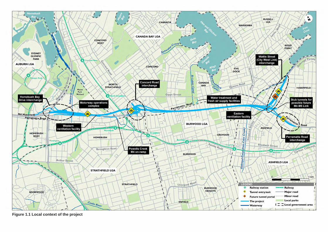
Figure 1.1 Local context of the project
WestConnex M4 East 3 WestConnex Delivery Authority Social Impact Assessment
Figure 1.2 WestConnex
The tunnel dive structures would start at the centre of the M4, west of the existing pedestrian footbridge over the M4 at Pomeroy Street, and would continue underground to the north of the existing M4 and Parramatta Road, before crossing beneath Parramatta Road at Broughton Street at Burwood. The tunnels would continue underground to the south of Parramatta Road until the intersection of Parramatta Road and Wattle Street at Haberfield. Ramps would connect the tunnels to Parramatta Road and Wattle Street (City West Link) at the eastern end of the project. The tunnels would end in a stub connection to the possible future M4–M5 Link (M4–M5 Link), near Alt Street at Haberfield.
The project would include interchanges between the tunnels and the above ground road network, along with other surface road works, at the following locations:
M4 and Homebush Bay Drive interchange at Sydney Olympic Park and Homebush (Homebush Bay Drive interchange)
Powells Creek, near George Street at North Strathfield (Powells Creek M4 on-ramp)
Queen Street, near Parramatta Road at North Strathfield (Queen Street cycleway westbound on-ramp)
M4 and Sydney Street, Concord Road and Parramatta Road interchange at North Strathfield (Concord Road interchange)
Wattle Street (City West Link), between Parramatta Road and Waratah Street at Haberfield (Wattle Street (City West Link) interchange)
Parramatta Road, between Bland Street and Orpington Street at Ashfield and Haberfield (Parramatta Road interchange).
WestConnex M4 East 4 WestConnex Delivery Authority Social Impact Assessment
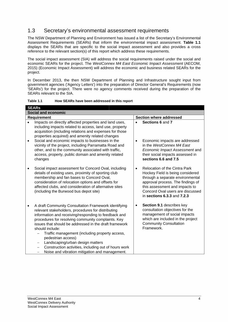
1.3 Secretary’s environmental assessment requirements The NSW Department of Planning and Environment has issued a list of the Secretary’s Environmental Assessment Requirements (SEARs) that inform the environmental impact assessment. Table 1.1 displays the SEARs that are specific to the social impact assessment and also provides a cross reference to the relevant section(s) of this report which address these requirements.
The social impact assessment (SIA) will address the social requirements raised under the social and economic SEARs for the project. The WestConnex M4 East Economic Impact Assessment (AECOM, 2015) (Economic Impact Assessment) will address the economic and business related SEARs for the project.
In December 2013, the then NSW Department of Planning and Infrastructure sought input from government agencies ('Agency Letters') into the preparation of Director General’s Requirements (now 'SEARs') for the project. There were no agency comments received during the preparation of the SEARs relevant to the SIA.
Table 1.1 How SEARs have been addressed in this report
SEARs Social and economic Requirement Section where addressed Impacts on directly affected properties and land uses,
including impacts related to access, land use, property acquisition (including relations and expenses for those properties acquired) and amenity related changes
Social and economic impacts to businesses in the vicinity of the project, including Parramatta Road and other, and to the community associated with traffic, access, property, public domain and amenity related changes
Social impact assessment for Concord Oval, including details of existing uses, proximity of sporting club membership and fan bases to Concord Oval, consideration of relocation options and offsets for affected clubs, and consideration of alternative sites (including the Burwood bus depot site)
A draft Community Consultation Framework identifying
relevant stakeholders, procedures for distributing information and receiving/responding to feedback and procedures for resolving community complaints. Key issues that should be addressed in the draft framework should include: Traffic management (including property access,
pedestrian access) Landscaping/urban design matters Construction activities, including out of hours work Noise and vibration mitigation and management.
Sections 6 and 7 Economic impacts are addressed
in the WestConnex M4 East Economic Impact Assessment and their social impacts assessed in sections 6.6 and 7.5
Relocation of the Cintra Park Hockey Field is being considered through a separate environmental approval process. The findings of this assessment and impacts to Concord Oval users are discussed in sections 6.3.3 and 7.2.3
Section 9.1 describes key consultation objectives for the management of social impacts which are included in the project Community Consultation Framework.
WestConnex M4 East 5 WestConnex Delivery Authority Social Impact Assessment
1.4 Purpose of this report This report presents the findings of the social impact assessment (SIA) for the project. The SIA provides:
An analysis of the existing social profile of the local area and communities that would be impacted, as well as the regional context
Outcomes from consultation with residents, businesses and key stakeholders
Identification of potential social benefits and negative impacts from the project
Mitigation strategies for each identified impact.
1.5 Study Area The study area for this SIA considers both local and regional study areas.
The regional study area (the region) for this SIA covers the five LGAs (Auburn, Strathfield, Canada Bay, Burwood and Ashfield) within which the project is located. This region represents the broader communities that would experience changed access and traffic conditions in their regional area as a result of the project. Additionally, the Greater Sydney Region has been used for comparative purposes and as the wider catchment for the project. An outline of the study area is provided in Table 1.2.
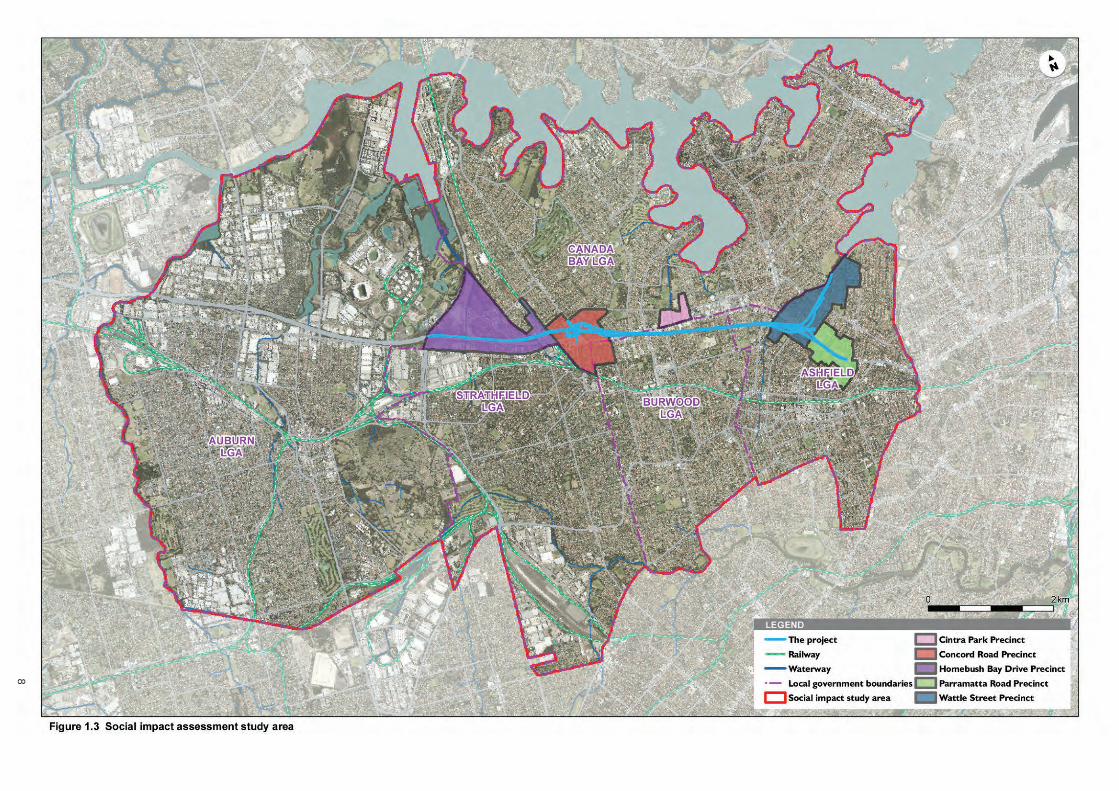
The local study area has been defined by five precincts in the vicinity of project surface works, as illustrated in Figure 1.3.
These local precincts are referred to according to the area where they are located or defining features and include:
Homebush
Concord
Cintra Park
Wattle Street, Haberfield
Parramatta Road, Ashfield.
The local precincts have been chosen to consider potential social changes to communities in close proximity to the project surface works and in particular those that would experience the most physical change1. Significant subsurface works associated with the project such as tunnelling would occur outside these precincts however, in the construction stage, these are not expected to impact at the surface. A definition of the local study area precincts is provided in Table 1.3.
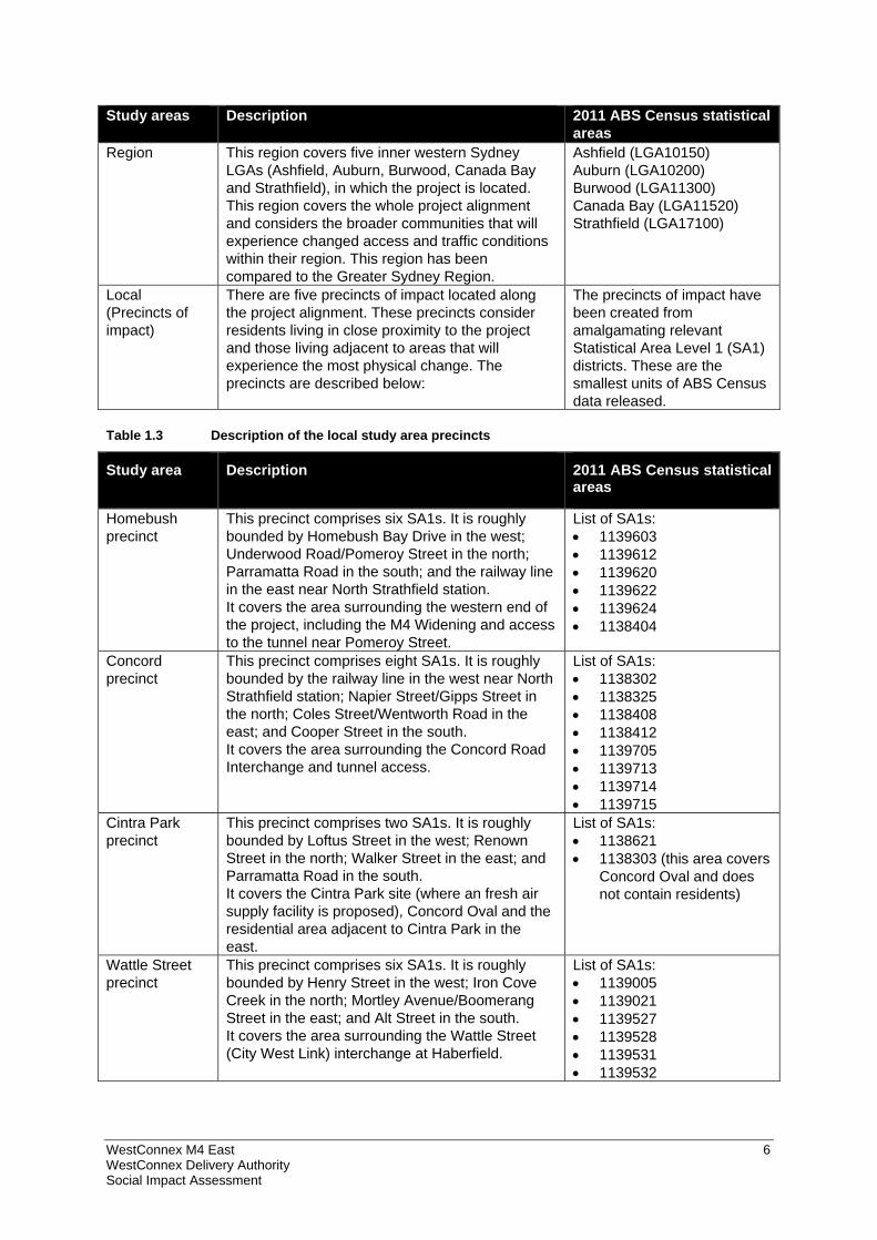
Table 1.2 Description of the study areas
Study areas Description 2011 ABS Census statistical areas
Greater Sydney Region
The Greater Sydney Region comprises the Greater Sydney Metropolitan Area. The key demographic indicators of the local study area and region have been compared to the Greater Sydney Region averages.
Greater Sydney Capital City Statistical Area (1GSYD)
1 The local study area for the social assessment includes smaller precincts as they relate to bulk of direct and indirect social impacts which will be experienced related to surface works. Alternatively, the WestConnex M4 East Economic Impact Assessment has considered a much larger local catchment to assess business and economic impacts, as these will be more extensively along the Parramatta Road corridor, particularly relating to changes in passing trade.
WestConnex M4 East 6 WestConnex Delivery Authority Social Impact Assessment
Study areas Description 2011 ABS Census statistical areas
Region This region covers five inner western Sydney LGAs (Ashfield, Auburn, Burwood, Canada Bay and Strathfield), in which the project is located. This region covers the whole project alignment and considers the broader communities that will experience changed access and traffic conditions within their region. This region has been compared to the Greater Sydney Region.
Ashfield (LGA10150) Auburn (LGA10200) Burwood (LGA11300) Canada Bay (LGA11520) Strathfield (LGA17100)
Local (Precincts of impact)
There are five precincts of impact located along the project alignment. These precincts consider residents living in close proximity to the project and those living adjacent to areas that will experience the most physical change. The precincts are described below:
The precincts of impact have been created from amalgamating relevant Statistical Area Level 1 (SA1) districts. These are the smallest units of ABS Census data released.
Table 1.3 Description of the local study area precincts
Study area Description 2011 ABS Census statistical areas
Homebush precinct
This precinct comprises six SA1s. It is roughly bounded by Homebush Bay Drive in the west; Underwood Road/Pomeroy Street in the north; Parramatta Road in the south; and the railway line in the east near North Strathfield station. It covers the area surrounding the western end of the project, including the M4 Widening and access to the tunnel near Pomeroy Street.
List of SA1s: 1139603 1139612 1139620 1139622 1139624 1138404
Concord precinct
This precinct comprises eight SA1s. It is roughly bounded by the railway line in the west near North Strathfield station; Napier Street/Gipps Street in the north; Coles Street/Wentworth Road in the east; and Cooper Street in the south. It covers the area surrounding the Concord Road Interchange and tunnel access.
List of SA1s: 1138302 1138325 1138408 1138412 1139705 1139713 1139714 1139715
Cintra Park precinct
This precinct comprises two SA1s. It is roughly bounded by Loftus Street in the west; Renown Street in the north; Walker Street in the east; and Parramatta Road in the south. It covers the Cintra Park site (where an fresh air supply facility is proposed), Concord Oval and the residential area adjacent to Cintra Park in the east.
List of SA1s: 1138621 1138303 (this area covers
Concord Oval and does not contain residents)
Wattle Street precinct
This precinct comprises six SA1s. It is roughly bounded by Henry Street in the west; Iron Cove Creek in the north; Mortley Avenue/Boomerang Street in the east; and Alt Street in the south. It covers the area surrounding the Wattle Street (City West Link) interchange at Haberfield.
List of SA1s: 1139005 1139021 1139527 1139528 1139531 1139532
WestConnex M4 East 7 WestConnex Delivery Authority Social Impact Assessment
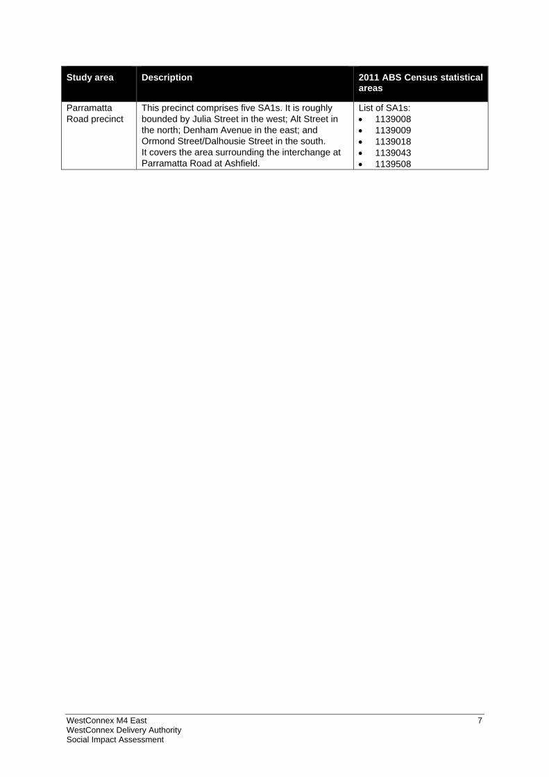
Study area Description 2011 ABS Census statistical areas
Parramatta Road precinct
This precinct comprises five SA1s. It is roughly bounded by Julia Street in the west; Alt Street in the north; Denham Avenue in the east; and Ormond Street/Dalhousie Street in the south. It covers the area surrounding the interchange at Parramatta Road at Ashfield.
List of SA1s: 1139008 1139009 1139018 1139043 1139508
8
WestConnex M4 East 9 WestConnex Delivery Authority Social Impact Assessment
2 Proposed project
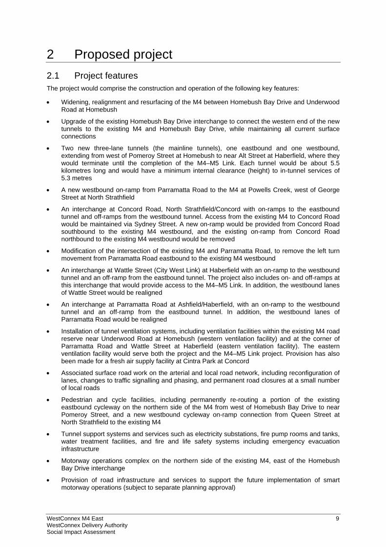
2.1 Project features The project would comprise the construction and operation of the following key features:
Widening, realignment and resurfacing of the M4 between Homebush Bay Drive and Underwood Road at Homebush
Upgrade of the existing Homebush Bay Drive interchange to connect the western end of the new tunnels to the existing M4 and Homebush Bay Drive, while maintaining all current surface connections
Two new three-lane tunnels (the mainline tunnels), one eastbound and one westbound, extending from west of Pomeroy Street at Homebush to near Alt Street at Haberfield, where they would terminate until the completion of the M4–M5 Link. Each tunnel would be about 5.5 kilometres long and would have a minimum internal clearance (height) to in-tunnel services of 5.3 metres
A new westbound on-ramp from Parramatta Road to the M4 at Powells Creek, west of George Street at North Strathfield
An interchange at Concord Road, North Strathfield/Concord with on-ramps to the eastbound tunnel and off-ramps from the westbound tunnel. Access from the existing M4 to Concord Road would be maintained via Sydney Street. A new on-ramp would be provided from Concord Road southbound to the existing M4 westbound, and the existing on-ramp from Concord Road northbound to the existing M4 westbound would be removed
Modification of the intersection of the existing M4 and Parramatta Road, to remove the left turn movement from Parramatta Road eastbound to the existing M4 westbound
An interchange at Wattle Street (City West Link) at Haberfield with an on-ramp to the westbound tunnel and an off-ramp from the eastbound tunnel. The project also includes on- and off-ramps at this interchange that would provide access to the M4–M5 Link. In addition, the westbound lanes of Wattle Street would be realigned
An interchange at Parramatta Road at Ashfield/Haberfield, with an on-ramp to the westbound tunnel and an off-ramp from the eastbound tunnel. In addition, the westbound lanes of Parramatta Road would be realigned
Installation of tunnel ventilation systems, including ventilation facilities within the existing M4 road reserve near Underwood Road at Homebush (western ventilation facility) and at the corner of Parramatta Road and Wattle Street at Haberfield (eastern ventilation facility). The eastern ventilation facility would serve both the project and the M4–M5 Link project. Provision has also been made for a fresh air supply facility at Cintra Park at Concord
Associated surface road work on the arterial and local road network, including reconfiguration of lanes, changes to traffic signalling and phasing, and permanent road closures at a small number of local roads
Pedestrian and cycle facilities, including permanently re-routing a portion of the existing eastbound cycleway on the northern side of the M4 from west of Homebush Bay Drive to near Pomeroy Street, and a new westbound cycleway on-ramp connection from Queen Street at North Strathfield to the existing M4
Tunnel support systems and services such as electricity substations, fire pump rooms and tanks, water treatment facilities, and fire and life safety systems including emergency evacuation infrastructure
Motorway operations complex on the northern side of the existing M4, east of the Homebush Bay Drive interchange
Provision of road infrastructure and services to support the future implementation of smart motorway operations (subject to separate planning approval)
WestConnex M4 East 10 WestConnex Delivery Authority Social Impact Assessment
Installation of tolling gantries and traffic control systems along the length of the project
Provision of new and modified noise walls
Provision of low noise pavement for new and modified sections of the existing M4
Temporary construction ancillary facilities and temporary works to facilitate the construction of the project.
An overview of the project at completion is shown in Figure 2.1.
The project does not include work required for reconfiguring Parramatta Road as part of the urban transformation program. The project does not include ongoing motorway maintenance activities during operation. These would be subject to separate assessment and approval as appropriate.
2.2 Construction activities
2.2.1 Overview Construction activities associated with the project would generally include:
Enabling and temporary works, including construction power, water supply, ancillary site establishment, demolition works, property adjustments and public transport modifications (if required)
Construction of the road tunnels, interchanges, intersections and roadside infrastructure
Haulage of spoil generated during tunnelling and excavation activities
Fitout of the road tunnels and support infrastructure, including ventilation and emergency response systems
Construction and fitout of the motorway operations complex and other ancillary operations buildings
Realignment, modification or replacement of surface roads, bridges and underpasses
Implementation of environmental management and pollution control facilities for the project.
The project assessed in this report does not include surveys, sampling or investigation to inform the design or assessment, such as test drilling, test excavations, geotechnical investigations, or other tests. It also does not include adjustments to, or relocation of, existing utilities infrastructure undertaken prior to commencement of construction. These would be subject to separate assessment and approval as appropriate.
2.2.2 Construction footprint The total area required for construction of the project, including construction ancillary facilities, is referred to as the ‘construction footprint’. The construction footprint would be about 65 hectares in total, comprising about 48 hectares at the surface and about 17 hectares below ground.
In addition to below ground works, surface works would be required to support tunnelling activities and to construct surface infrastructure such as interchanges, tunnel portals, ventilation facilities, ancillary operations buildings and facilities, and new cycleway facilities near the Homebush Bay Drive interchange and Queen Street at North Strathfield.
The overall surface construction footprint generally aligns with the operational footprint, with the locations of future operational ancillary facilities being used to support construction work. Some additional areas adjacent to the operational footprint (around the portals and on- and off-ramps, and also at the tunnel mid-point) would also be required during the construction stage only to facilitate construction.
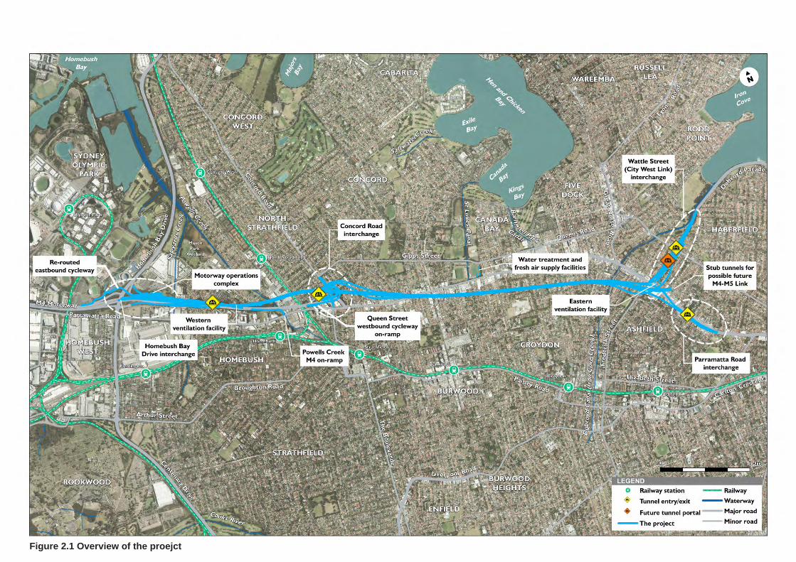
Figure 2.1 Overview of the proejct
WestConnex M4 East 12 WestConnex Delivery Authority Social Impact Assessment
Construction ancillary facilities currently proposed would be required at the following 10 locations:
Homebush Bay Drive civil site (C1)
Pomeroy Street civil site (C2)
Underwood Road civil and tunnel site (C3)
Powells Creek civil site (C4)
Concord Road civil and tunnel site (C5)
Cintra Park tunnel site (C6)
Northcote Street tunnel site (C7)
Eastern ventilation facility site (C8)
Wattle Street and Walker Avenue civil site (C9)
Parramatta Road civil site (C10).
An overview of the construction footprint is shown in Figure 2.2.
The final size and configuration of construction ancillary facilities would be further developed during detailed design.
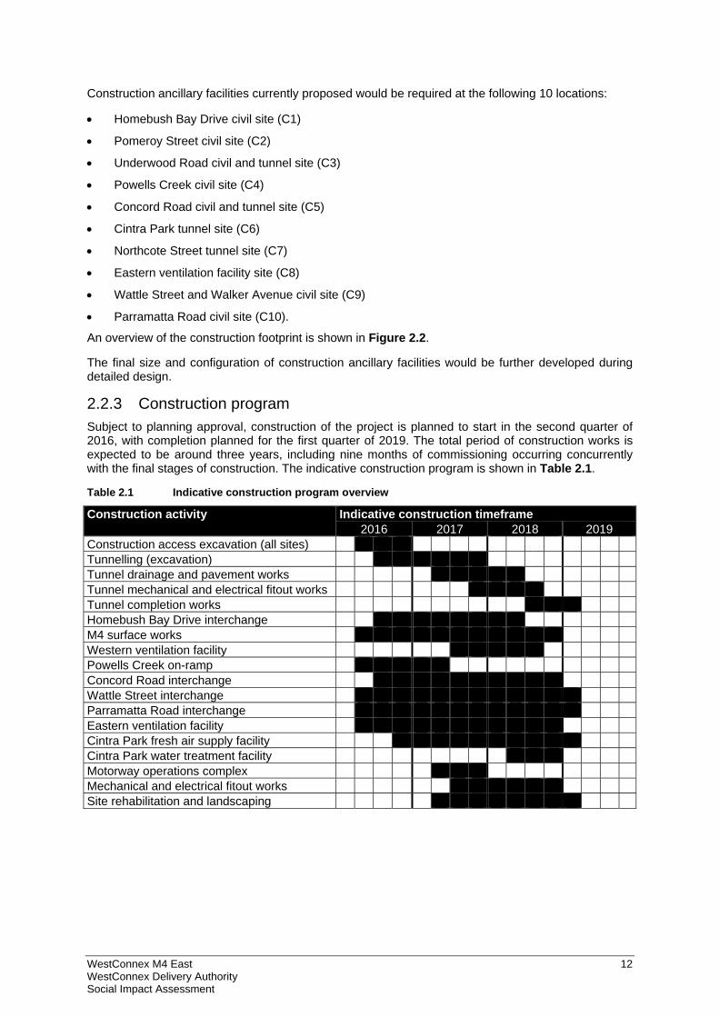
2.2.3 Construction program Subject to planning approval, construction of the project is planned to start in the second quarter of 2016, with completion planned for the first quarter of 2019. The total period of construction works is expected to be around three years, including nine months of commissioning occurring concurrently with the final stages of construction. The indicative construction program is shown in Table 2.1.
Table 2.1 Indicative construction program overview
Construction activity Indicative construction timeframe 2016 2017 2018 2019
Construction access excavation (all sites) Tunnelling (excavation) Tunnel drainage and pavement works Tunnel mechanical and electrical fitout works Tunnel completion works Homebush Bay Drive interchange M4 surface works Western ventilation facility Powells Creek on-ramp Concord Road interchange Wattle Street interchange Parramatta Road interchange Eastern ventilation facility Cintra Park fresh air supply facility Cintra Park water treatment facility Motorway operations complex Mechanical and electrical fitout works Site rehabilitation and landscaping
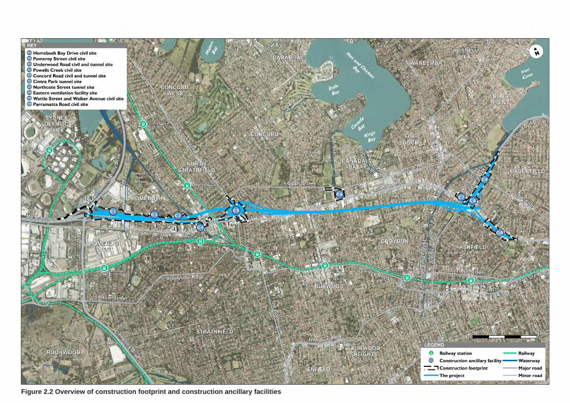
Figure 2.2 Overview of construction footprint and construction ancillary facilities
WestConnex M4 East 14 WestConnex Delivery Authority Social Impact Assessment
2.3 Specific aspects relevant to social impact assessment
2.3.1 Property acquisition The project has been designed to minimise land acquisition and limit the severance of private properties.
The project would involve full acquisition of around 167 residential properties and partial acquisition of around 15 properties: a total of 182 residential properties. These comprise private property and land owned by councils, public authorities or the State of NSW. In addition, 98 properties owned by Roads and Maritime would be affected by the project. In total it is estimated that approximately 168 dwellings would be impacted by acquisition.
In addition to land to be acquired, it is anticipated that four properties would be leased during construction. One of these properties would be returned to its owner in its entirety following construction, while the other three would also be affected by permanent partial acquisition (and are included above as properties to be acquired).
Following construction, where feasible, residual land not required for operational project components would be made available for redevelopment. The project does not involve consolidation or rezoning of residual land. The future use of this residual land would be subject to separate assessment and planning approval as necessary.
Figure 6.1 to Figure 6.5 shows the location of property to be acquired and land already owned by Roads and Maritime.
Where partial acquisitions are required, associated property adjustment, such as realignment of private property fencing, would be undertaken. Access to all properties not affected by acquisition or temporary lease would be maintained throughout construction and operation of the project.
The total area and number of properties that would be acquired and leased for the project may change as the project is refined during detailed design, or in response to changes resulting from the exhibition of this EIS and conditions of approval that may be applied by the Minister for Planning.
Final partial and full property acquisitions would be confirmed through detailed design and undertaken in accordance with the Land Acquisition Information Guide (Roads and Maritime 2014) and the Land Acquisition (Just Terms Compensation) Act 1991 (NSW). Consultation with affected property owners has commenced and would continue throughout detailed design.
2.3.2 Construction vehicle access and parking The proposed access and egress points to and from the construction ancillary facilities are summarised in Table 2.2 below.
Table 2.2 Indicative access routes to and from construction ancillary facilities
Site Proposed access route
Homebush Bay Drive civil site (C1) and Pomeroy Street civil site (C2)
Heavy vehicles – via existing M4 Light vehicles – via existing M4 and Pomeroy Street
Underwood Road civil and tunnel site (C3) Underwood Road and Short Street East Powells Creek civil site (C4) Heavy vehicles – Powell Street and Underwood
Road Light vehicles – Powell Street and Parramatta Road
Concord Road civil and tunnel site (C5) Heavy vehicles – Sydney Street (M4 off-ramp) and Concord Road Light vehicles – Alexandra Street and Ada Street
Cintra Park tunnel site (C6) Heavy vehicles – Parramatta Road Light vehicles – Gipps Street
Northcote Street tunnel site (C7) Parramatta Road and Wattle Street Eastern ventilation facility site (C8) Heavy vehicles – Parramatta Road and Wattle
Street Light vehicles – Walker Avenue
WestConnex M4 East 15 WestConnex Delivery Authority Social Impact Assessment
Site Proposed access route
Wattle Street and Walker Avenue civil site (C9)
Wattle Street
Parramatta Road civil site (C10) Heavy vehicles – Parramatta Road Light vehicles – Orpington Street
Construction traffic movements would include heavy and light vehicles associated with spoil and waste removal, material deliveries and the arrival and departure of construction workers.
The majority of the construction sites would have parking for staff based at those sites.
An upgraded car park on the northern side of Concord Oval would provide about 250 car parking spaces. This would serve as the parking area for the main project office during the week. This site would also be available for use by the public on weekends and on weeknights, with the following spaces allocated to both groups:
145 public parking spaces on Saturdays (leaving 100 for the construction workforce)
195 public parking spaces on Sundays (leaving 50 for the construction workforce)
145 public parking spaces on weeknights after 6.30pm (leaving 100 for the construction workforce).
This allocation is indicative only and would be further refined following consultation with Canada Bay Council and Concord Oval user groups.
An additional car park site has also been identified at Railway Lane containing about 50 car parking spaces. The site is owned by Roads and Maritime and is currently occupied by the North Strathfield Rail Underpass (NSRU) Alliance. NSRU works will be completed by mid-2015, leaving this site available for use as an overflow car park. This car park is within walking distance of the Underwood Road civil and tunnel site (C3), Powells Creek civil site (C4) and the Concord Road civil and tunnel site (C5).
The construction workforce would be encouraged to utilise public transport. Parramatta Road is a major transport corridor that has multiple bus routes. The study area is also well serviced by the rail network with seven stations within walking distance of the construction sites.
In addition, a construction car parking strategy would be developed as part of the Traffic Management and Safety Plan to limit impacts on the surrounding communities, in consultation with local councils and stakeholders associated with the sporting facilities adjacent to the project site.
2.3.3 Changes to local roads The project would require some temporary road closures and diversions to facilitate construction. These measures are detailed in Table 2.3.
At all locations where road closures are required, access would be maintained to properties throughout the construction period. Appropriate signage for road closures or detours would be installed.
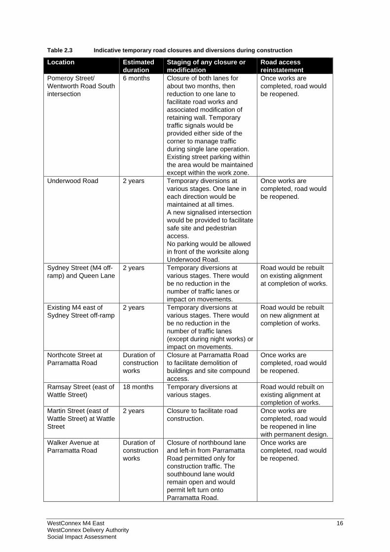
WestConnex M4 East 16 WestConnex Delivery Authority Social Impact Assessment
Table 2.3 Indicative temporary road closures and diversions during construction
Location Estimated duration
Staging of any closure or modification
Road access reinstatement
Pomeroy Street/ Wentworth Road South intersection
6 months Closure of both lanes for about two months, then reduction to one lane to facilitate road works and associated modification of retaining wall. Temporary traffic signals would be provided either side of the corner to manage traffic during single lane operation. Existing street parking within the area would be maintained except within the work zone.
Once works are completed, road would be reopened.
Underwood Road
2 years Temporary diversions at various stages. One lane in each direction would be maintained at all times. A new signalised intersection would be provided to facilitate safe site and pedestrian access. No parking would be allowed in front of the worksite along Underwood Road.
Once works are completed, road would be reopened.
Sydney Street (M4 off-ramp) and Queen Lane
2 years Temporary diversions at various stages. There would be no reduction in the number of traffic lanes or impact on movements.
Road would be rebuilt on existing alignment at completion of works.
Existing M4 east of Sydney Street off-ramp
2 years Temporary diversions at various stages. There would be no reduction in the number of traffic lanes (except during night works) or impact on movements.
Road would be rebuilt on new alignment at completion of works.
Northcote Street at Parramatta Road
Duration of construction works
Closure at Parramatta Road to facilitate demolition of buildings and site compound access.
Once works are completed, road would be reopened.
Ramsay Street (east of Wattle Street)
18 months Temporary diversions at various stages.
Road would rebuilt on existing alignment at completion of works.
Martin Street (east of Wattle Street) at Wattle Street
2 years Closure to facilitate road construction.
Once works are completed, road would be reopened in line with permanent design.
Walker Avenue at Parramatta Road
Duration of construction works
Closure of northbound lane and left-in from Parramatta Road permitted only for construction traffic. The southbound lane would remain open and would permit left turn onto Parramatta Road.
Once works are completed, road would be reopened.
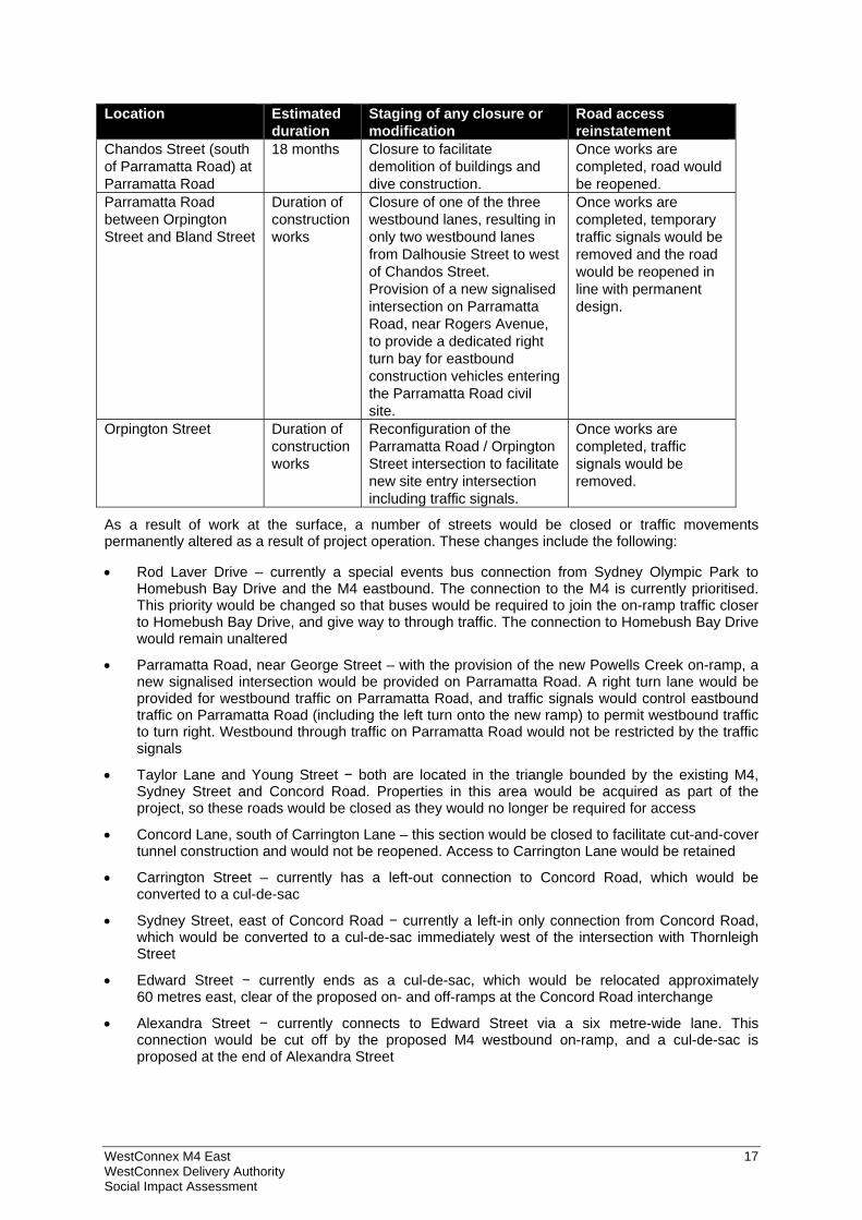
WestConnex M4 East 17 WestConnex Delivery Authority Social Impact Assessment
Location Estimated duration
Staging of any closure or modification
Road access reinstatement
Chandos Street (south of Parramatta Road) at Parramatta Road
18 months Closure to facilitate demolition of buildings and dive construction.
Once works are completed, road would be reopened.
Parramatta Road between Orpington Street and Bland Street
Duration of construction works
Closure of one of the three westbound lanes, resulting in only two westbound lanes from Dalhousie Street to west of Chandos Street. Provision of a new signalised intersection on Parramatta Road, near Rogers Avenue, to provide a dedicated right turn bay for eastbound construction vehicles entering the Parramatta Road civil site.
Once works are completed, temporary traffic signals would be removed and the road would be reopened in line with permanent design.
Orpington Street Duration of construction works
Reconfiguration of the Parramatta Road / Orpington Street intersection to facilitate new site entry intersection including traffic signals.
Once works are completed, traffic signals would be removed.
As a result of work at the surface, a number of streets would be closed or traffic movements permanently altered as a result of project operation. These changes include the following:
Rod Laver Drive – currently a special events bus connection from Sydney Olympic Park to Homebush Bay Drive and the M4 eastbound. The connection to the M4 is currently prioritised. This priority would be changed so that buses would be required to join the on-ramp traffic closer to Homebush Bay Drive, and give way to through traffic. The connection to Homebush Bay Drive would remain unaltered
Parramatta Road, near George Street – with the provision of the new Powells Creek on-ramp, a new signalised intersection would be provided on Parramatta Road. A right turn lane would be provided for westbound traffic on Parramatta Road, and traffic signals would control eastbound traffic on Parramatta Road (including the left turn onto the new ramp) to permit westbound traffic to turn right. Westbound through traffic on Parramatta Road would not be restricted by the traffic signals
Taylor Lane and Young Street − both are located in the triangle bounded by the existing M4, Sydney Street and Concord Road. Properties in this area would be acquired as part of the project, so these roads would be closed as they would no longer be required for access
Concord Lane, south of Carrington Lane – this section would be closed to facilitate cut-and-cover tunnel construction and would not be reopened. Access to Carrington Lane would be retained
Carrington Street – currently has a left-out connection to Concord Road, which would be converted to a cul-de-sac
Sydney Street, east of Concord Road − currently a left-in only connection from Concord Road, which would be converted to a cul-de-sac immediately west of the intersection with Thornleigh Street
Edward Street − currently ends as a cul-de-sac, which would be relocated approximately 60 metres east, clear of the proposed on- and off-ramps at the Concord Road interchange
Alexandra Street − currently connects to Edward Street via a six metre-wide lane. This connection would be cut off by the proposed M4 westbound on-ramp, and a cul-de-sac is proposed at the end of Alexandra Street
WestConnex M4 East 18 WestConnex Delivery Authority Social Impact Assessment
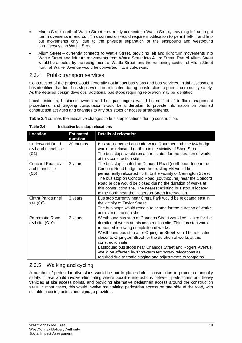
Martin Street north of Wattle Street − currently connects to Wattle Street, providing left and right turn movements in and out. This connection would require modification to permit left-in and left-out movements only, due to the physical separation of the eastbound and westbound carriageways on Wattle Street
Allum Street – currently connects to Wattle Street, providing left and right turn movements into Wattle Street and left turn movements from Wattle Street into Allum Street. Part of Allum Street would be affected by the realignment of Wattle Street, and the remaining section of Allum Street north of Walker Avenue would be converted into a cul-de-sac.
2.3.4 Public transport services Construction of the project would generally not impact bus stops and bus services. Initial assessment has identified that four bus stops would be relocated during construction to protect community safety. As the detailed design develops, additional bus stops requiring relocation may be identified.
Local residents, business owners and bus passengers would be notified of traffic management procedures, and ongoing consultation would be undertaken to provide information on planned construction activities and changes to any bus stops or access arrangements.
Table 2.4 outlines the indicative changes to bus stop locations during construction.
Table 2.4 Indicative bus stop relocations
Location Estimated duration
Details of relocation
Underwood Road civil and tunnel site (C3)
20 months Bus stops located on Underwood Road beneath the M4 bridge would be relocated north to in the vicinity of Short Street. The bus stops would remain relocated for the duration of works at this construction site.
Concord Road civil and tunnel site (C5)
3 years The bus stop located on Concord Road (northbound) near the Concord Road bridge over the existing M4 would be permanently relocated north to the vicinity of Carrington Street. The bus stop on Concord Road (southbound) near the Concord Road bridge would be closed during the duration of works at this construction site. The nearest existing bus stop is located to the north near the Patterson Street intersection.
Cintra Park tunnel site (C6)
3 years Bus stop currently near Cintra Park would be relocated east in the vicinity of Taylor Street. The bus stops would remain relocated for the duration of works at this construction site.
Parramatta Road civil site (C10)
2 years Westbound bus stop at Chandos Street would be closed for the duration of works at this construction site. This bus stop would reopened following completion of works. Westbound bus stop after Orpington Street would be relocated closer to Orpington Street for the duration of works at this construction site. Eastbound bus stops near Chandos Street and Rogers Avenue would be affected by short-term temporary relocations as required due to traffic staging and adjustments to footpaths.
2.3.5 Walking and cycling A number of pedestrian diversions would be put in place during construction to protect community safety. These would involve eliminating where possible interactions between pedestrians and heavy vehicles at site access points, and providing alternative pedestrian access around the construction sites. In most cases, this would involve maintaining pedestrian access on one side of the road, with suitable crossing points and signage provided.
WestConnex M4 East 19 WestConnex Delivery Authority Social Impact Assessment
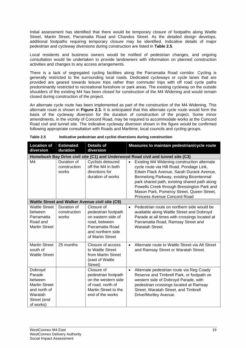
Initial assessment has identified that there would be temporary closure of footpaths along Wattle Street, Martin Street, Parramatta Road and Chandos Street. As the detailed design develops, additional footpaths requiring temporary closure may be identified. Indicative details of major pedestrian and cycleway diversions during construction are listed in Table 2.5.
Local residents and business owners would be notified of pedestrian changes, and ongoing consultation would be undertaken to provide landowners with information on planned construction activities and changes to any access arrangements.
There is a lack of segregated cycling facilities along the Parramatta Road corridor. Cycling is generally restricted to the surrounding local roads. Dedicated cycleways or cycle lanes that are provided are geared towards leisure trips rather than commuter trips with off road cycle paths predominantly restricted to recreational foreshore or park areas. The existing cycleway on the outside shoulders of the existing M4 has been closed for construction of the M4 Widening and would remain closed during construction of the project.
An alternate cycle route has been implemented as part of the construction of the M4 Widening. This alternate route is shown in Figure 2.3. It is anticipated that this alternate cycle route would form the basis of the cycleway diversion for the duration of construction of the project. Some minor amendments, in the vicinity of Concord Road, may be required to accommodate works at the Concord Road civil and tunnel site. The indicative cycleway diversion shown in the figure would be confirmed following appropriate consultation with Roads and Maritime, local councils and cycling groups.
Table 2.5 Indicative pedestrian and cyclist diversions during construction
Location of diversion
Estimated duration
Details of diversion
Measures to maintain pedestrian/cycle route
Homebush Bay Drive civil site (C1) and Underwood Road civil and tunnel site (C3) M4 Duration of
construction works
Cyclists detoured off the M4 in both directions for duration of works
Existing M4 Widening construction alternate cycle route via Hill Road, Pondage Link, Edwin Flack Avenue, Sarah Durack Avenue, Bennelong Parkway, existing Bicentennial park shared path, existing shared path along Powells Creek through Bressington Park and Mason Park, Pomeroy Street, Queen Street, Princess Avenue Concord Road
Wattle Street and Walker Avenue civil site (C9) Wattle Street between Parramatta Road and Martin Street
Duration of construction works
Closure of pedestrian footpath on eastern side of road, between Parramatta Road and northern side of Martin Street
Pedestrian route on northern side would be available along Wattle Street and Dobroyd Parade at all times with crossings located at Parramatta Road, Ramsay Street and Waratah Street.
Martin Street south of Wattle Street
25 months Closure of access to Wattle Street from Martin Street (east of Wattle Street)
Alternate route to Wattle Street via Alt Street and Ramsay Street or Waratah Street.
Dobroyd Parade between Martin Street and north of Waratah Street (end of works)
Closure of pedestrian footpath on the western side of road, north of Martin Street to the end of the works
Alternate pedestrian route via Reg Coady Reserve and Timbrell Park, or footpath on western side of Dobroyd Parade, with pedestrian crossings located at Ramsay Street, Waratah Street, and Timbrell Drive/Mortley Avenue.
WestConnex M4 East 20 WestConnex Delivery Authority Social Impact Assessment
Location of diversion
Estimated duration
Details of diversion
Measures to maintain pedestrian/cycle route
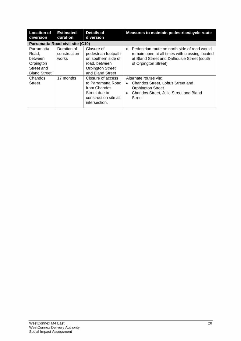
Parramatta Road civil site (C10) Parramatta Road, between Orpington Street and Bland Street
Duration of construction works
Closure of pedestrian footpath on southern side of road, between Orpington Street and Bland Street
Pedestrian route on north side of road would remain open at all times with crossing located at Bland Street and Dalhousie Street (south of Orpington Street)
Chandos Street
17 months Closure of access to Parramatta Road from Chandos Street due to construction site at intersection.
Alternate routes via: Chandos Street, Loftus Street and
Orphington Street Chandos Street, Julie Street and Bland
Street
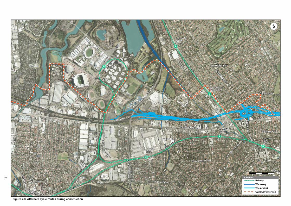
!!Ã
!!Ã
!!Ã
!!Ã
!!Ã
!!Ã
!!Ã
!!Ã
M4 Motorway
Parramatta Road
Olym
picD
r ive
Concord Road
Arthur Street
Railway Street
Beres
ford
Road
LeicesterAvenue
Gipps Street
Centen ary
Drive
Homeb
ush Ba
y Driv
e
Church Street
Broughton Road
OlympicPark
Railway
Main Suburban Railway
Main
NorthernRailway
North StrathfieldRailway Station
FlemingtonRailwayStation
StrathfieldRailwayStation
Concord WestRailwayStation
Olympic ParkRailwayStation
HomebushRailwayStation
AUBURN
BURWOOD
CANADA BAY
STRATHFIELD
!!N#
Figure 2.3 Alternate cycle routes during construction
0 500m
LEGENDRailway
Waterway
The project
Cycleway diversion
X-X
21
WestConnex M4 East 22 WestConnex Delivery Authority Social Impact Assessment
3 Assessment methodology
3.1 Methodology This SIA has been developed in accordance with the Roads and Maritime Environmental Impact Assessment Practice Note: Socio-economic assessment. These guidelines identify a range of impact categories and types, and provide a framework for this assessment. This SIA constitutes a “moderate” investigation, as defined in the practice note. A moderate level assessment applies to projects with several impacts, medium duration impacts or impacts on groups of people.
It should be noted that potential economic impacts have been assessed in the Economic Impact Assessment. The outcomes of the Economic Impact Assessment have been reviewed and presented in this SIA.
The SIA has included the following:
Site visits to review existing land uses and local conditions in the study area (see section 1.5)
Development and analysis of a community profile from desktop sources including the Australian Bureau of Statistics (ABS) 2011 Census. Census data has been sourced for Auburn, Strathfield, Burwood, Canada Bay and Ashfield local government areas, with comparison made to the Greater Sydney Region. More detailed analysis has been undertaken for each of the areas that would experience the most physical change (e.g. property acquisition) with 2011 Census data sourced for relevant Statistical Area Level 1 (SA1) and aggregated to reflect the local precincts of impact (see section 5 for more detail)2
Social research to identify and consider local issues and community values
Review of the project’s other technical reports prepared for the EIS relating to transport, noise and vibration, non-Indigenous heritage, visual impact and urban design and economic assessment
Analysis of the outcomes of community consultation undertaken by WDA during the period December 2013 to February 2014 and June to July 2015, including with users of Cintra Park and Concord Oval
Consultation with local social service providers to further understand the local socio-economic environment and the potential impacts of the project on local communities
Social impact assessment, identifying potential social impacts and benefits that would result from the proposal.
The SIA has drawn significantly on consultation with project affected stakeholders undertaken by WDA during land acquisition and community engagement activities. WDA has consulted with representatives of local councils within the project area during 2014 and 2015 and augmented consultation with key affected social infrastructure providers.
3.2 Impact assessment framework and rating A range of categories and associated concepts relevant to assessing the social impacts of transport infrastructure have been developed from experience gained from several transport focused SIAs, as well as from a review of other major Australian road infrastructure projects.
2 The SIA has assessed smaller local impact areas than the EIA. The SIA has confined the local study area to those areas in the vicinity of surface works, addressing broader social impacts within the regional area (which is broadly consistent with the wider catchment used in the Economic Impact Assessment), whereas the Economic Impact Assessment study area has been chosen to capture business impacts along the Parramatta Road corridor (e.g. loss of passing trade).
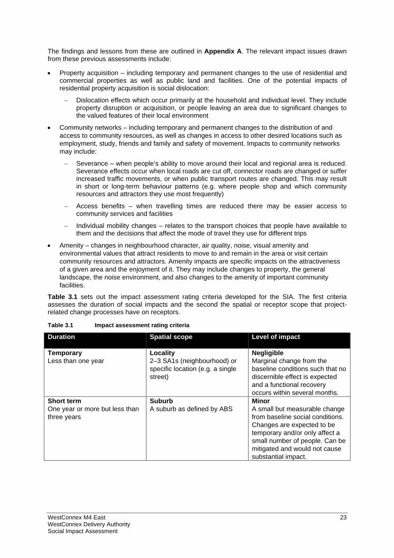
WestConnex M4 East 23 WestConnex Delivery Authority Social Impact Assessment
The findings and lessons from these are outlined in Appendix A. The relevant impact issues drawn from these previous assessments include:
Property acquisition – including temporary and permanent changes to the use of residential and commercial properties as well as public land and facilities. One of the potential impacts of residential property acquisition is social dislocation:
Dislocation effects which occur primarily at the household and individual level. They include property disruption or acquisition, or people leaving an area due to significant changes to the valued features of their local environment
Community networks – including temporary and permanent changes to the distribution of and access to community resources, as well as changes in access to other desired locations such as employment, study, friends and family and safety of movement. Impacts to community networks may include:
Severance – when people’s ability to move around their local and regional area is reduced. Severance effects occur when local roads are cut off, connector roads are changed or suffer increased traffic movements, or when public transport routes are changed. This may result in short or long-term behaviour patterns (e.g. where people shop and which community resources and attractors they use most frequently)
Access benefits – when travelling times are reduced there may be easier access to community services and facilities
Individual mobility changes – relates to the transport choices that people have available to them and the decisions that affect the mode of travel they use for different trips
Amenity – changes in neighbourhood character, air quality, noise, visual amenity and environmental values that attract residents to move to and remain in the area or visit certain community resources and attractors. Amenity impacts are specific impacts on the attractiveness of a given area and the enjoyment of it. They may include changes to property, the general landscape, the noise environment, and also changes to the amenity of important community facilities.
Table 3.1 sets out the impact assessment rating criteria developed for the SIA. The first criteria assesses the duration of social impacts and the second the spatial or receptor scope that project-related change processes have on receptors.
Table 3.1 Impact assessment rating criteria
Duration Spatial scope Level of impact
Temporary Less than one year
Locality 2–3 SA1s (neighbourhood) or specific location (e.g. a single street)
Negligible Marginal change from the baseline conditions such that no discernible effect is expected and a functional recovery occurs within several months.
Short term One year or more but less than three years
Suburb A suburb as defined by ABS
Minor A small but measurable change from baseline social conditions. Changes are expected to be temporary and/or only affect a small number of people. Can be mitigated and would not cause substantial impact.
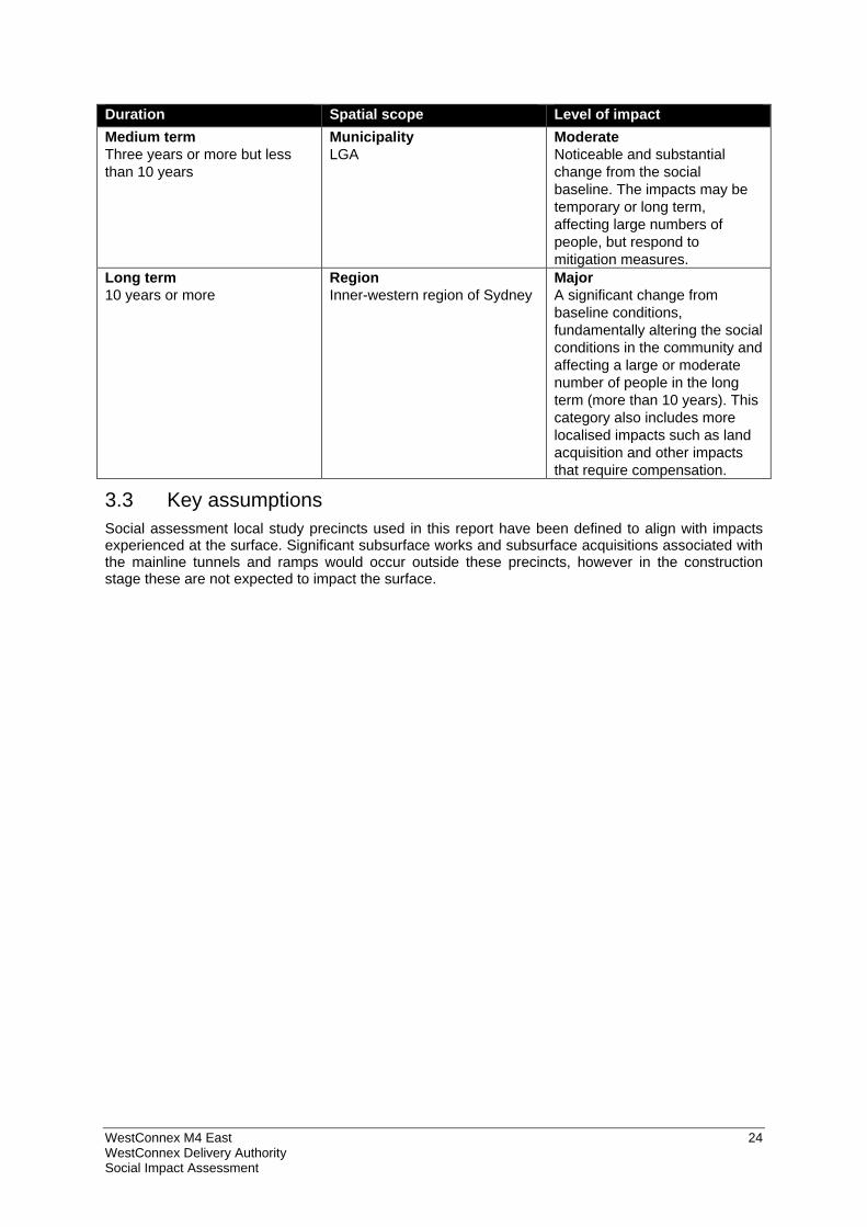
WestConnex M4 East 24 WestConnex Delivery Authority Social Impact Assessment
Duration Spatial scope Level of impact Medium term Three years or more but less than 10 years
Municipality LGA
Moderate Noticeable and substantial change from the social baseline. The impacts may be temporary or long term, affecting large numbers of people, but respond to mitigation measures.
Long term 10 years or more
Region Inner-western region of Sydney
Major A significant change from baseline conditions, fundamentally altering the social conditions in the community and affecting a large or moderate number of people in the long term (more than 10 years). This category also includes more localised impacts such as land acquisition and other impacts that require compensation.
3.3 Key assumptions Social assessment local study precincts used in this report have been defined to align with impacts experienced at the surface. Significant subsurface works and subsurface acquisitions associated with the mainline tunnels and ramps would occur outside these precincts, however in the construction stage these are not expected to impact the surface.
WestConnex M4 East 25 WestConnex Delivery Authority Social Impact Assessment
4 Social policy context
4.1 Introduction This section presents an overview of the relevant strategic documents which inform and guide the SIA. This includes policies and plans from various state and local government agencies.
4.2 A Plan for Growing Sydney A Plan for Growing Sydney (NSW Government 2014) is a broad framework prepared by the NSW Government to guide Sydney’s development over the next twenty years. It predicts that Sydney will grow by approximately 1.6 million people in the next twenty years. This will generate the need for approximately 664,000 new homes and 689,000 new jobs across the Sydney Metropolitan area. The strategy identifies four key goals that will support growth:
A competitive economy with world-class services and transport
A city of housing choice with homes that meet our needs and lifestyles
A great place to live with communities that are strong, healthy and well connected
A sustainable and resilient city that protects the natural environment and has a balanced approach to the use of land and resources.
The plan identifies Western Sydney as a key hub for Sydney’s freight industry. It anticipates that WestConnex will better connect Western and South-western Sydney with the Sydney CBD.
A range of objectives are identified under each of these goals. Those with most relevance to the project and this SIA are outlined below.
Direction 1.5: Enhance capacity at Sydney's gateways and freight networks
WestConnex will improve connections between agriculture industries in regional NSW and Sydney’s ports, making goods export more cost efficient.
Action 2.2.2: Undertake urban renewal in transport corridors which are being transformed by investment, and around strategic centres
WestConnex is identified as a catalyst for major urban renewal along the Parramatta Road corridor. It is expected to improve local amenity along Parramatta Road by reducing through-traffic on surface roads, and allowing for enhanced north-south local connectivity.
4.3 NSW 2021: A Plan to Make NSW Number One NSW 2021: A Plan to Make NSW Number One (NSW Department of Premier and Cabinet 2011) (NSW 2021) is the NSW Government’s 10-year strategic business plan. It sets priorities for action and guides resource allocation to deliver economic growth and critical infrastructure throughout NSW. The NSW 2021 Performance Report 2014–2015 (NSW Department of Premier and Cabinet 2014) provides information on how the NSW Government intends to measure and deliver on the goals, targets and measures outlined in NSW 2021.
NSW 2021 emphasises investment in and delivery of an efficient and effective transport system including road infrastructure that will relieve congestion, reduce travel times, improve road safety and enhance and expand capacity on key road corridors. These outcomes will contribute to both the national and state economies as well as reducing the costs of doing business for many large and small businesses and services.
Within the context of the goals identified in NSW 2021, the project (as part of WestConnex) would help to achieve several priority actions by expanding the capacity of the M4 and extending it further east along the Parramatta Road corridor. The key goals of the plan of relevance to the SIA are:
Goal 4 – Increase the competitiveness of doing business in NSW
WestConnex M4 East 26 WestConnex Delivery Authority Social Impact Assessment
Goal 7 – Reduce travel times
Goal 8 – Grow public transport patronage
Goal 10 – Improve road safety
Goal 19 – Invest in critical infrastructure
Goal 20 – Build liveable centres.
4.4 State Infrastructure Strategy The State Infrastructure Strategy 2012–2032 (Infrastructure NSW 2012) (State Infrastructure Strategy) is a 20-year strategy which identifies and prioritises the delivery of critical public infrastructure to drive productivity and economic growth. Infrastructure NSW’s assessment of the State’s existing infrastructure has highlighted critical deficiencies in urban road capacity. The State Infrastructure Strategy identifies strategic infrastructure options to meet the challenges of population growth and substantial increases in freight volumes.
The State Infrastructure Strategy recognises the economic impacts and other constraints created by reduced functionality along the M4 corridor.
In November 2014, Infrastructure NSW released a revised State Infrastructure Strategy – the State Infrastructure Strategy Update 2014 (State Infrastructure Strategy Update) to guide the allocation of funds from the sale of the State’s ‘poles and wires’ electricity network businesses, as part of the NSW Government’s Rebuilding NSW initiative.
The State Infrastructure Strategy Update identified the possible expansion of WestConnex to include connections to Victoria Road and the Anzac Bridge to the north (the Northern Extension), and a connection to President Avenue at Rockdale to the south (the Southern Extension). The State Infrastructure Strategy also highlights investigations into a third road crossing of Sydney Harbour (the Western Harbour Tunnel), which would connect to the possible WestConnex Northern Extension and provide access to North Sydney between the Gore Hill and Warringah freeways. This possible new tunnel, together with the M4−M5 Link, would avoid the need to travel through the CBD.
4.5 NSW Long Term Transport Master Plan The NSW Long Term Transport Master Plan (Transport for NSW 2012) (Transport Master Plan) provides a framework for delivering an integrated, modern and multi-modal transport system by identifying NSW’s transport actions and investment priorities for the next 20 years. Under the Transport Master Plan, WestConnex is identified as a critical link in Sydney’s motorway network and an immediate priority for the NSW Government.
The Transport Master Plan recognises that WestConnex would encourage Sydney’s long-term economic growth by supporting the growing freight task between Sydney’s international gateways and Greater Western Sydney, facilitating the transfer of goods and services between Sydney’s eastern and western economic centres by improving capacity and reducing travel times, and supporting the continued development of Sydney’s global economic corridor
4.6 Draft Parramatta Road Urban Transformation Program The New Parramatta Rd: Draft Parramatta Road Urban Renewal Strategy (UrbanGrowth NSW 2015) (Parramatta Road Urban Renewal Strategy) identifies areas along the corridor where there will be a focus on encouraging growth and changes in the long term (about 20 years). The aim of the strategy is to create an environment with good design, land use mix, housing choice and infrastructure, as well as improved access to community facilities and services and access to public and active transport. It is envisaged that up to 40,000 new dwellings and 50,000 new jobs would be generated in the urban renewal precincts.
A Parramatta Road Urban Transformation Program is being undertaken in parallel with the project to implement the strategy. A concept plan is currently being developed with stakeholders to guide the long-term renewal of the corridor. The concept plan integrates land use and transport planning, optimising locations and scale of growth close to transport and open space networks.
WestConnex M4 East 27 WestConnex Delivery Authority Social Impact Assessment
A key element of this program is improved public transport services along Parramatta Road. The project would enable traffic reductions on Parramatta Road from Burwood to the CBD, which would in turn free up road space and create greater public transport options for existing and new residents along the Parramatta Road corridor. This road program is also planning for the construction and delivery of walking and cycling infrastructure in key locations along the corridor.
Over recent years the following issues have contributed to the deterioration of the streetscape along Parramatta Road:
More than 90,000 vehicles, including up to 6000 trucks, travel each weekday on some sections of the road
Noise, visual clutter from cables, poles and signage and a lack of street trees to relieve the urban landscape
Poor north−south connection across the corridor for pedestrians, cyclists and motorists
Planning of the corridor has not been uniform or coordinated across the 10 councils located along the corridor.
To improve the corridor, the Parramatta Road Strategy has identified eight urban renewal precincts at Granville, Auburn, Homebush, Burwood, Kings Bay (Five Dock), Taverners Hill, Leichhardt and Camperdown. These precincts were selected because of their:
Proximity to places of employment
Accessibility, especially to public transport
Capacity to support new housing types
Proximity to existing infrastructure
Opportunity for future development
Unique character and diversity
Potential for new or refreshed linkages.
WestConnex is identified within the Parramatta Road Strategy as a catalyst for the restoration of the Parramatta Road corridor, because it would reduce through traffic from the Parramatta Road corridor. ‘Through traffic’ in this context refers to traffic that travels more than five kilometres along Parramatta Road to destinations away from Parramatta Road. The reduction in traffic, particularly trucks, would assist in improving public transport and urban amenity, both of which would support future growth along the corridor, in particular residential development.
The regional project area contains three of these urban renewal precincts: Homebush, Burwood and Kings Bay (Five Dock). The Homebush urban renewal precinct is expected to accommodate approximately one third of all population growth in the Parramatta Road corridor under the renewal program. The project would result in a reduction in the number of vehicles along Parramatta Road in these locations, which would help support future growth. While the project alone would not facilitate the growth of areas along Parramatta Road, in combination with other WestConnex projects it would assist in improving amenity along the corridor, making the corridor more attractive for future growth.
4.7 Council community strategic plans Under the Local Government Amendment (Planning and Reporting) Act 2009 (NSW), all councils in NSW are required to develop long-term community strategic plans in consultation with their communities. These plans set an overarching vision and a coordinated approach to planning and delivery for each local government area (LGA). Reviewing community strategic plans therefore provides insight into the aspirations and priorities of communities.
The community strategic plans for Auburn, Strathfield, Canada Bay, Burwood and Ashfield have been reviewed to gain an understanding of the values and relevant issues for the communities that would be most impacted by the proposal.
WestConnex M4 East 28 WestConnex Delivery Authority Social Impact Assessment
4.7.1 Auburn City Community Strategic Plan 2013-2023 Auburn City Community Strategic Plan 2013-2023 is a 10 year vision that was developed following consultations with 7000 community members in 2010, with further consultations in 2012 and 2013.
Themes
Auburn City Council has identified four themes for the Community Strategic Plan. The themes and priority areas relevant to the WestConnex project and this SIA are outlined below.
1. Our community – diverse and inclusive
Increased community education and safety programs
Building community harmony and social cohesion
Building a positive image of our local area
Improved health and wellbeing of community members
Better distribution of services and facilities across Auburn City.
2. Our places – attractive and liveable
Improved cleanliness and attractiveness of town centres
Improved planning for residential developments and growth areas
Better access to and provision of public transport
Continued level of maintenance of roads and footpaths
Increased provision of parking
Improved traffic management.
3. Our environment – healthy and green
Continued maintenance and improvement of local parks and playgrounds
Protection of low rise residential areas
Improved tree maintenance
Improved provision of open space through better town planning.
4. Our leadership – visionary and responsible
Improved responsiveness to complaints and enquiries
Development of effective partnerships to increase resources into the area.
4.7.2 Strathfield 2025 Strathfield Council developed Strathfield 2025 following consultation with the community in 2011 and 2012. The vision outlined in the plan is:
Strathfield is a well-connected urban centre in Sydney’s Inner West with rich cultural diversity and a strong sense of community cohesion. The community is engaged with Council in guiding a sustainable future and opportunities for education, recreation, employment and overall wellbeing in Strathfield.
Community priorities
Ten priorities were identified during the community engagement process in 2011 and 2012. These priorities were: transport; community safety; quality of life and civic pride; well-maintained local area; local environment; Council leadership; community participation and cohesion; community facilities and programs; and business.
WestConnex M4 East 29 WestConnex Delivery Authority Social Impact Assessment
Of most relevance to the project is the transport priority, within which five sub-themes were identified:
Address traffic congestion
Improve mobility, ease and safety of public and private transport
Improve access and availability of public transport
Improve parking availability and controls
Maintain roads and footpaths.
Guiding principles
Strathfield Council has identified ‘sustainability’ and ‘social justice’ as guiding principles for its Community Strategic Plan. Sustainability is explained as meeting the needs of the present community without compromising the ability of future communities (that is, future generations) to meet their own needs. This is a holistic approach that is intended to extend across social, economic, environmental and civic leadership needs.
Strathfield Council also conveys a commitment to social justice, by which it means:
Equitable distribution of resources
Rights are recognised and promoted
Access is provided to resources and services required to meet basic needs and improve quality of life on a fair basis
Participation and consultation opportunities are available for those affected by decisions.
Themes
In the context of the above, five key themes have been identified. A summary of the relevant themes in the context of this SIA have been outlined below.
1. Connectivity
Movement to and from Strathfield is easy and safe
Infrastructure and development is integrated, planned and sustainable
2. Community wellbeing
Strathfield is a safe and healthy place
Strathfield community is healthy, active and inclusive
Strathfield is a harmonious community with a strong sense of community cohesion
3. Prosperity and opportunities
Development of industrial and commercial areas is sustainable and well planned
4. Liveable neighbourhoods
Strathfield has high quality sustainable urban design that mixes well designed and innovative development with existing local character
Strathfield’s neighbourhoods are clean, attractive and well maintained
Strathfield’s natural environment is protected and enhanced
5. Responsible leadership
The Strathfield community trusts Council and is informed, valued and heard.
WestConnex M4 East 30 WestConnex Delivery Authority Social Impact Assessment
4.7.3 City of Canada Bay – FuturesPlan20 The City of Canada Bay first developed a community strategic plan, FuturesPlan20, in 2008. It has since been reviewed in 2010 and 2012, with community consultation undertaken during the initial development and subsequent reviews.
Themes
The City of Canada Bay has identified four themes for its Community Strategic Plan. The themes and goals relevant to WestConnex and this SIA are outlined below.
1. Active and vibrant
Residents feel a sense of health and wellbeing
There are places for residents to participate in sport and other outdoor recreation
There are services that meet residents individual needs
Residents have awareness and respect for local Aboriginal heritage and culture.
2. Sustainable spaces and places
Residents are proud of and value their city’s natural environmental assets
Residents live in a clean, healthy local environment
Residents feel safe and comfortable using community spaces
The city has attractive streets, village centres and public spaces
The city has attractive landscapes with sustainable development and where heritage is conserved.
3. Innovative and engaged
Residents have opportunities to participate in and contribute their opinions to local decision making through consultation and other forms of engagement with Council
The city is well managed and residents’ needs are met through high quality services and well maintained facilities and infrastructure.
4. Thriving and connected
The city has a range of housing options
Residents can walk or cycle on designated paths to a range of commercial, recreational and community spaces around the city
Residents can get where they need to go safely without too much delay
Residents have good day to day public transport options which take them to the places they need to go.
4.7.4 Burwood 2030 Burwood 2030 was developed following broad community consultation in 2009, 2010 and 2013. The community vision for Burwood outlined in the plan is: ‘A well connected, sustainable and safe community that embraces and celebrates its diversity’.
Themes
Council has articulated five themes, and identified a number of strategic goals for each theme. The themes and goals relevant to this SIA are outlined below.
1. A sense of community
A safe community for residents, workers and visitors
High quality activities, facilities and services
WestConnex M4 East 31 WestConnex Delivery Authority Social Impact Assessment
A well informed, supported and engaged community
A community that celebrates diversity.
2. Leadership through innovation
Strong partnerships to benefit the community
3. A Sustainable natural environment
Maintain and enhance open green spaces and streetscapes.
4. Accessible services and facilities
Effective traffic management and adequate parking provision
Accessible services and facilities that are well utilised
Encourage active and healthy lives
Vibrant and clean streetscape.
5. A vibrant economic community
Support and manage Burwood’s major centre status
Support small business
Increase employment and training opportunities
Economic centre growth and preserved residential areas.
4.7.5 Ashfield 2023 Ashfield 2023 is a ten year plan that was developed from a broad community engagement process. The community vision for Ashfield by 2023 is: ‘A caring community of linked villages inspired by its rich cultural history, heritage and diversity’.
Themes
Seven key themes have been identified based on the community’s aspirations and priorities. Those priorities which are most relevant to this SIA are highlighted below.
1. Creative and inclusive community
Improving individual and collective wellbeing with services and programs that support individuals at all stages of life and levels of ability
Community programs and activities that are accessible to everyone
Creating places that connect people and facilities, and public spaces that build community spirit through everyday use.
2. Unique and distinctive neighbourhoods
Encourage more local employment through diverse and mixed services and facilities. Encourage the revitalisation of local corner stores and business development which supports local jobs
Creating plans and policies to ensure the distinct urban village atmosphere and local heritage are valued and protected
Delivering clean, attractive streets, well-maintained footpaths and street furniture that helps to promote pride in our neighbourhoods and create safe, pleasant places.
3. Safe, connected and accessible places
Promoting sustainable living and improving pedestrian routes, cycleways and an active transport network that will connect people with the places there they live, work and relax
Reducing the reliance on private cars
WestConnex M4 East 32 WestConnex Delivery Authority Social Impact Assessment
Providing a wide variety of facilities and places for recreation and community activities that promote a healthy lifestyle.
4. Living sustainably
Promoting sustainable transport use through planning processes
Promoting active lifestyles and facilitating active transport e.g. improved infrastructure.
5. Thriving local economy
Creating main street economies that are vibrant and desirable locations for businesses, visitors and residents
Promoting Liverpool Road and the Parramatta Road enterprise corridor to business and investment sectors
Connectivity and accessibility for visitors to the area.
6. Attractive and lively town centre
Create an urban framework that balances access, using various forms of transport, with the need to develop an attractive, enjoyable and safe place
Beautify the streetscape and public domain.
7. Engaging and innovative local democracy
Ashfield Council will be recognised for excellence in our community engagement and for listening to and responding to the needs and concerns of all residents.
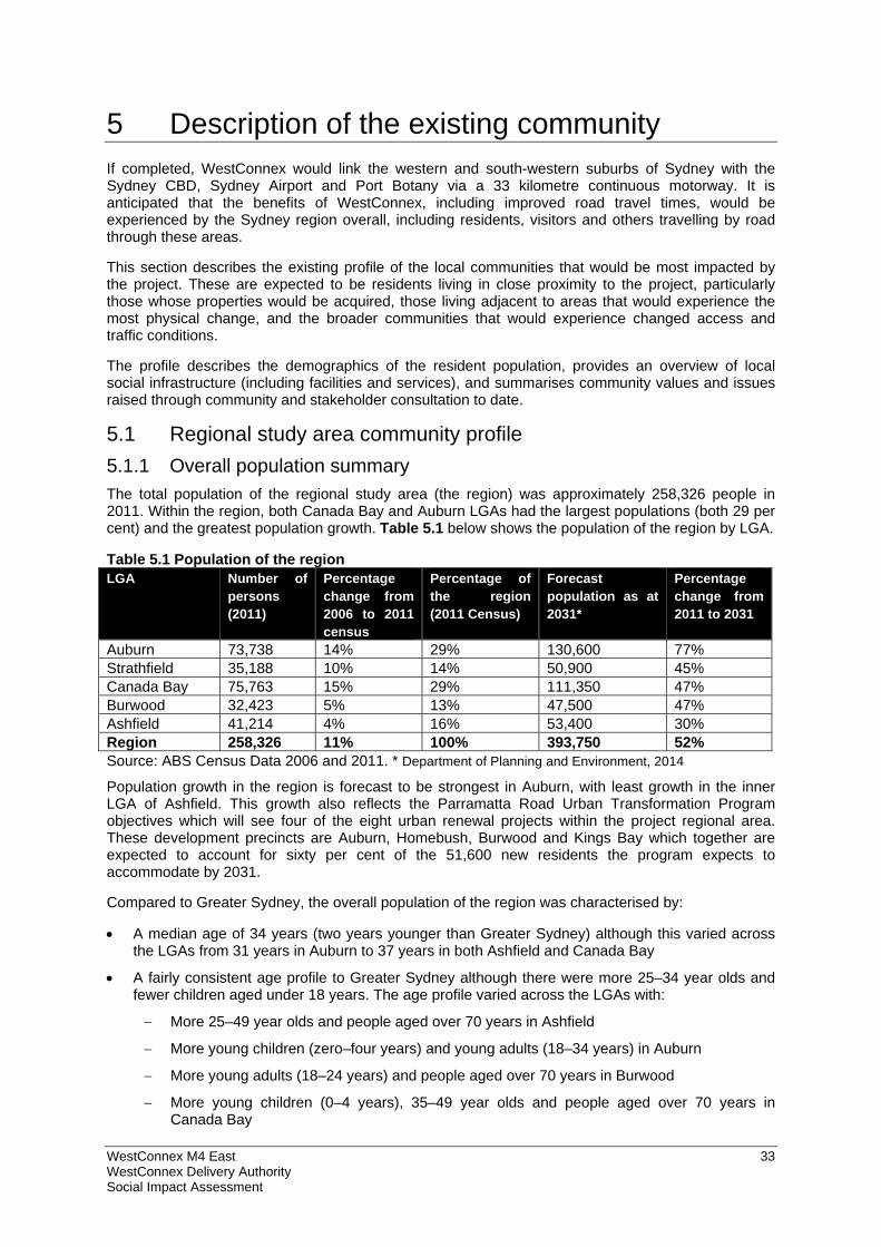
WestConnex M4 East 33 WestConnex Delivery Authority Social Impact Assessment
5 Description of the existing community If completed, WestConnex would link the western and south-western suburbs of Sydney with the Sydney CBD, Sydney Airport and Port Botany via a 33 kilometre continuous motorway. It is anticipated that the benefits of WestConnex, including improved road travel times, would be experienced by the Sydney region overall, including residents, visitors and others travelling by road through these areas.
This section describes the existing profile of the local communities that would be most impacted by the project. These are expected to be residents living in close proximity to the project, particularly those whose properties would be acquired, those living adjacent to areas that would experience the most physical change, and the broader communities that would experience changed access and traffic conditions.
The profile describes the demographics of the resident population, provides an overview of local social infrastructure (including facilities and services), and summarises community values and issues raised through community and stakeholder consultation to date.
5.1 Regional study area community profile
5.1.1 Overall population summary The total population of the regional study area (the region) was approximately 258,326 people in 2011. Within the region, both Canada Bay and Auburn LGAs had the largest populations (both 29 per cent) and the greatest population growth. Table 5.1 below shows the population of the region by LGA.
Table 5.1 Population of the region LGA Number of
persons (2011)
Percentage change from 2006 to 2011 census
Percentage of the region (2011 Census)
Forecast population as at 2031*
Percentage change from 2011 to 2031
Auburn 73,738 14% 29% 130,600 77% Strathfield 35,188 10% 14% 50,900 45% Canada Bay 75,763 15% 29% 111,350 47% Burwood 32,423 5% 13% 47,500 47% Ashfield 41,214 4% 16% 53,400 30% Region 258,326 11% 100% 393,750 52% Source: ABS Census Data 2006 and 2011. * Department of Planning and Environment, 2014
Population growth in the region is forecast to be strongest in Auburn, with least growth in the inner LGA of Ashfield. This growth also reflects the Parramatta Road Urban Transformation Program objectives which will see four of the eight urban renewal projects within the project regional area. These development precincts are Auburn, Homebush, Burwood and Kings Bay which together are expected to account for sixty per cent of the 51,600 new residents the program expects to accommodate by 2031.
Compared to Greater Sydney, the overall population of the region was characterised by:
A median age of 34 years (two years younger than Greater Sydney) although this varied across the LGAs from 31 years in Auburn to 37 years in both Ashfield and Canada Bay
A fairly consistent age profile to Greater Sydney although there were more 25–34 year olds and fewer children aged under 18 years. The age profile varied across the LGAs with:
More 25–49 year olds and people aged over 70 years in Ashfield
More young children (zero–four years) and young adults (18–34 years) in Auburn
More young adults (18–24 years) and people aged over 70 years in Burwood
More young children (0–4 years), 35–49 year olds and people aged over 70 years in Canada Bay
WestConnex M4 East 34 WestConnex Delivery Authority Social Impact Assessment
More young people (12–34 years) in Strathfield.
A culturally diverse population in particular in Auburn, Strathfield and Burwood LGAs
A small proportion of Indigenous residents (0.5 per cent), with a similar proportion in each LGA (from 0.3 to 0.6 per cent)
A slightly higher unemployment rate (6.3 per cent). Of the five LGAs, Auburn had the highest unemployment rate (8.6 per cent) and Canada Bay had the lowest rate (4.3 per cent)
A higher rate of residents with a tertiary qualification (61 per cent). All the LGAs, except Auburn (53 per cent), had a similar proportion (61 to 66 per cent)
Most people lived in separate houses (44 per cent), followed by flats, units and apartments (39 per cent). This was reflected in all LGAs, except Ashfield, where most people lived in flats, units and apartments
Mostly family households (73 per cent), which was reflected across all the LGAs. Most households in the region were couples with children (49 per cent), also reflected across the LGAs
Slightly fewer lone person households (21 per cent). Ashfield and Canada Bay however had significant proportions of lone person households
Slightly fewer one parent families (14 per cent), which was reflected across all the LGAs
Similar weekly median household income ($1424), with the lowest household income in Auburn ($1160) and highest in Canada Bay ($1817)
Slightly lower rate of home ownership (with or without a mortgage) (62 per cent), with lowest rate in Ashfield and Auburn (both 59 per cent) and highest rate in Canada Bay (66 per cent)
Slightly higher rate of renting (38 per cent), with the highest rates in Ashfield (42 per cent) and Auburn (41 per cent) and lowest in Canada Bay (34 per cent)
Fewer public housing tenants (three per cent) although this varied across the LGAs, with the highest proportions of public housing tenants in Strathfield (4.2 per cent), Auburn (3.9 per cent) and Burwood (three per cent)
Close to half of the region's residents (48 per cent) have lived in the area for over five years, while over three-quarters (77 per cent) have lived there for over one year. This demonstrates that there are established communities and social networks in the region. Burwood, Ashfield and Canada Bay had the highest proportions of residents who had lived in their current home for over five years
While an index of relative socio-economic disadvantage is not available for the region, compared with LGAs in the region the index of relative socio-economic disadvantage indicated Auburn had a higher level of disadvantage.
5.2 Local study area – precinct profiles
5.2.1 Homebush precinct
Overall population summary The total population of the Homebush precinct was approximately 2093 people in 2011. Compared to the region and Greater Sydney, the population was characterised by:
A younger age profile, with significantly more people aged 18–34 years
A culturally diverse community
Higher median weekly household incomes
Higher level of renting as well as transience within the community, with mostly aged between 18–49 years moving in and out of the precinct
More people paying a mortgage
High rate of vehicle ownership and car dependency for travel to work
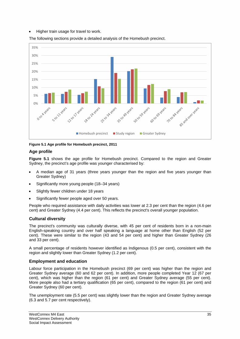
WestConnex M4 East 35 WestConnex Delivery Authority Social Impact Assessment
Higher train usage for travel to work.
The following sections provide a detailed analysis of the Homebush precinct.
Figure 5.1 Age profile for Homebush precinct, 2011
Age profile Figure 5.1 shows the age profile for Homebush precinct. Compared to the region and Greater Sydney, the precinct’s age profile was younger characterised by:
A median age of 31 years (three years younger than the region and five years younger than Greater Sydney)
Significantly more young people (18–34 years)
Slightly fewer children under 18 years
Significantly fewer people aged over 50 years.
People who required assistance with daily activities was lower at 2.3 per cent than the region (4.6 per cent) and Greater Sydney (4.4 per cent). This reflects the precinct's overall younger population.
Cultural diversity The precinct's community was culturally diverse, with 45 per cent of residents born in a non-main English-speaking country and over half speaking a language at home other than English (52 per cent). These were similar to the region (43 and 54 per cent) and higher than Greater Sydney (26 and 33 per cent).
A small percentage of residents however identified as Indigenous (0.5 per cent), consistent with the region and slightly lower than Greater Sydney (1.2 per cent).
Employment and education Labour force participation in the Homebush precinct (69 per cent) was higher than the region and Greater Sydney average (60 and 62 per cent). In addition, more people completed Year 12 (67 per cent), which was higher than the region (61 per cent) and Greater Sydney average (55 per cent). More people also had a tertiary qualification (65 per cent), compared to the region (61 per cent) and Greater Sydney (60 per cent).
The unemployment rate (5.5 per cent) was slightly lower than the region and Greater Sydney average (6.3 and 5.7 per cent respectively).
0%
5%
10%
15%
20%
25%
30%
35%
Homebush precinct Study region Greater Sydney
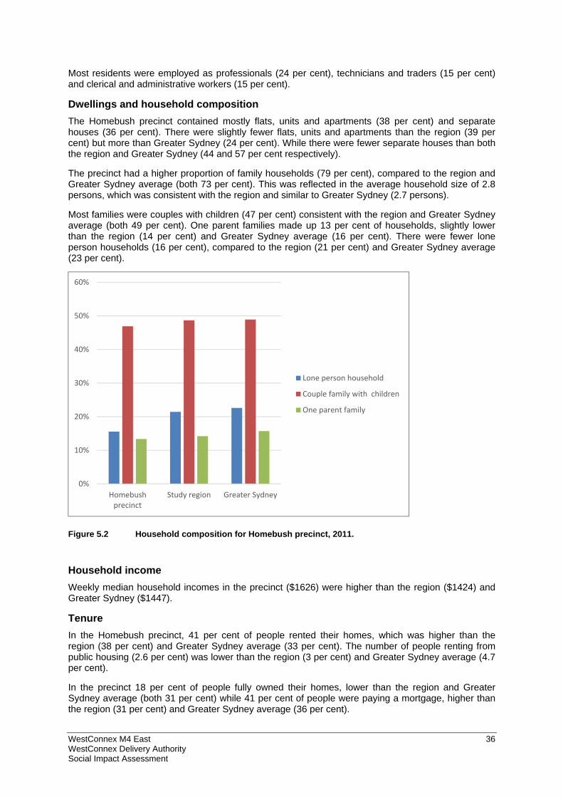
WestConnex M4 East 36 WestConnex Delivery Authority Social Impact Assessment
Most residents were employed as professionals (24 per cent), technicians and traders (15 per cent) and clerical and administrative workers (15 per cent).
Dwellings and household composition The Homebush precinct contained mostly flats, units and apartments (38 per cent) and separate houses (36 per cent). There were slightly fewer flats, units and apartments than the region (39 per cent) but more than Greater Sydney (24 per cent). While there were fewer separate houses than both the region and Greater Sydney (44 and 57 per cent respectively).
The precinct had a higher proportion of family households (79 per cent), compared to the region and Greater Sydney average (both 73 per cent). This was reflected in the average household size of 2.8 persons, which was consistent with the region and similar to Greater Sydney (2.7 persons).
Most families were couples with children (47 per cent) consistent with the region and Greater Sydney average (both 49 per cent). One parent families made up 13 per cent of households, slightly lower than the region (14 per cent) and Greater Sydney average (16 per cent). There were fewer lone person households (16 per cent), compared to the region (21 per cent) and Greater Sydney average (23 per cent).
Figure 5.2 Household composition for Homebush precinct, 2011.
Household income Weekly median household incomes in the precinct ($1626) were higher than the region ($1424) and Greater Sydney ($1447).
Tenure In the Homebush precinct, 41 per cent of people rented their homes, which was higher than the region (38 per cent) and Greater Sydney average (33 per cent). The number of people renting from public housing (2.6 per cent) was lower than the region (3 per cent) and Greater Sydney average (4.7 per cent).
In the precinct 18 per cent of people fully owned their homes, lower than the region and Greater Sydney average (both 31 per cent) while 41 per cent of people were paying a mortgage, higher than the region (31 per cent) and Greater Sydney average (36 per cent).
0%
10%
20%
30%
40%
50%
60%
Homebushprecinct
Study region Greater Sydney
Lone person household
Couple family with children
One parent family
WestConnex M4 East 37 WestConnex Delivery Authority Social Impact Assessment
Length of residence In 2011, 35 per cent of people in the Homebush precinct had lived at the same address for over five years, considerably lower than the region (48 per cent) and Greater Sydney average (53 per cent). Similarly, the proportion of residents who lived at the same address for over one year (69 per cent) was lower than the region (77 per cent) and Greater Sydney (80 per cent). This indicates a higher level of transience among residents.
Based on the precinct's younger age profile (refer to the age profile above), this indicates that the majority of people that moved to or purchased a home in the precinct were likely aged between 18–49 years.
SEIFA Index of Relative Disadvantage The 2011 Index of Relative Disadvantage scores for the precinct's smaller areas indicate that the population was generally less disadvantaged, similar to Strathfield LGA (1022).
Table 5.2 Index of Relative Disadvantage scores by smaller area within Homebush precinct, 2011
Smaller area within Homebush precinct
1139603 1139612 1139620 1139622 1139624 1138404 Strathfield LGA
2011 Index of Relative Disadvantage score
1023 1029 1037 N/A* 1039 1074 1022
*Due to the small population for this area, this data was not available.
Vehicle ownership There was a high level of vehicle ownership in the precinct, with 92 per cent of households owning at least one vehicle. This was higher than the region (85 per cent) and Greater Sydney (88 per cent).
Travel to work (by one method only) Most residents (56 per cent) in the Homebush precinct travelled to work as either a driver or passenger of a car. This was similar to the region (58 per cent) but lower than the Greater Sydney average (66 per cent).
In the precinct 34 per cent of residents travelled to work by train, which was significantly higher than the region (26 per cent) and Greater Sydney average (15 per cent). Bus usage (0.6 per cent) however was lower than the region (five per cent) and Greater Sydney average (six per cent). The proportion of people that walked only to work (four per cent) was consistent with the region (four per cent) and Greater Sydney (five per cent).
5.2.2 Concord precinct
Overall population summary The total population of Concord precinct was approximately 3693 people in 2011. Compared to the region and Greater Sydney, the population was characterised by:
A younger age profile, with significantly more people aged 18–34 years
A culturally diverse community
Lower median weekly household incomes
Higher level of renting as well as transience within the community, with mostly people likely aged between 18–49 years moving in and out of the precinct
More people paying a mortgage
Lower rate of vehicle ownership and car dependency for travel to work
Higher train usage for travel to work.
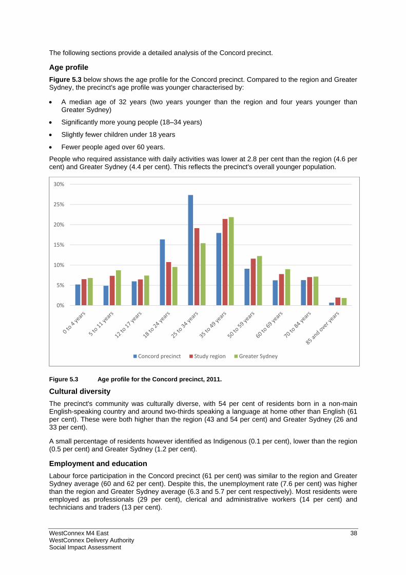
WestConnex M4 East 38 WestConnex Delivery Authority Social Impact Assessment
The following sections provide a detailed analysis of the Concord precinct.
Age profile Figure 5.3 below shows the age profile for the Concord precinct. Compared to the region and Greater Sydney, the precinct's age profile was younger characterised by:
A median age of 32 years (two years younger than the region and four years younger than Greater Sydney)
Significantly more young people (18–34 years)
Slightly fewer children under 18 years
Fewer people aged over 60 years.
People who required assistance with daily activities was lower at 2.8 per cent than the region (4.6 per cent) and Greater Sydney (4.4 per cent). This reflects the precinct's overall younger population.
Figure 5.3 Age profile for the Concord precinct, 2011.
Cultural diversity The precinct's community was culturally diverse, with 54 per cent of residents born in a non-main English-speaking country and around two-thirds speaking a language at home other than English (61 per cent). These were both higher than the region (43 and 54 per cent) and Greater Sydney (26 and 33 per cent).
A small percentage of residents however identified as Indigenous (0.1 per cent), lower than the region (0.5 per cent) and Greater Sydney (1.2 per cent).
Employment and education Labour force participation in the Concord precinct (61 per cent) was similar to the region and Greater Sydney average (60 and 62 per cent). Despite this, the unemployment rate (7.6 per cent) was higher than the region and Greater Sydney average (6.3 and 5.7 per cent respectively). Most residents were employed as professionals (29 per cent), clerical and administrative workers (14 per cent) and technicians and traders (13 per cent).
0%
5%
10%
15%
20%
25%
30%
Concord precinct Study region Greater Sydney
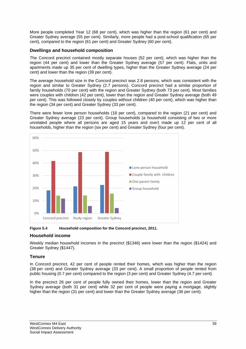
WestConnex M4 East 39 WestConnex Delivery Authority Social Impact Assessment
More people completed Year 12 (68 per cent), which was higher than the region (61 per cent) and Greater Sydney average (55 per cent). Similarly, more people had a post-school qualification (65 per cent), compared to the region (61 per cent) and Greater Sydney (60 per cent).
Dwellings and household composition The Concord precinct contained mostly separate houses (52 per cent), which was higher than the region (44 per cent) and lower than the Greater Sydney average (57 per cent). Flats, units and apartments made up 35 per cent of dwelling types, higher than the Greater Sydney average (24 per cent) and lower than the region (39 per cent).
The average household size in the Concord precinct was 2.8 persons, which was consistent with the region and similar to Greater Sydney (2.7 persons). Concord precinct had a similar proportion of family households (70 per cent) with the region and Greater Sydney (both 73 per cent). Most families were couples with children (42 per cent), lower than the region and Greater Sydney average (both 49 per cent). This was followed closely by couples without children (40 per cent), which was higher than the region (34 per cent) and Greater Sydney (33 per cent).
There were fewer lone person households (18 per cent), compared to the region (21 per cent) and Greater Sydney average (23 per cent). Group households (a household consisting of two or more unrelated people where all persons are aged 15 years and over) made up 12 per cent of all households, higher than the region (six per cent) and Greater Sydney (four per cent).
Figure 5.4 Household composition for the Concord precinct, 2011.
Household income Weekly median household incomes in the precinct ($1346) were lower than the region ($1424) and Greater Sydney ($1447).
Tenure In Concord precinct, 42 per cent of people rented their homes, which was higher than the region (38 per cent) and Greater Sydney average (33 per cent). A small proportion of people rented from public housing (0.7 per cent) compared to the region (3 per cent) and Greater Sydney (4.7 per cent).
In the precinct 26 per cent of people fully owned their homes, lower than the region and Greater Sydney average (both 31 per cent) while 32 per cent of people were paying a mortgage, slightly higher than the region (31 per cent) and lower than the Greater Sydney average (36 per cent).
0%
10%
20%
30%
40%
50%
60%
Concord precinct Study region Greater Sydney
Lone person household
Couple family with children
One parent family
Group household
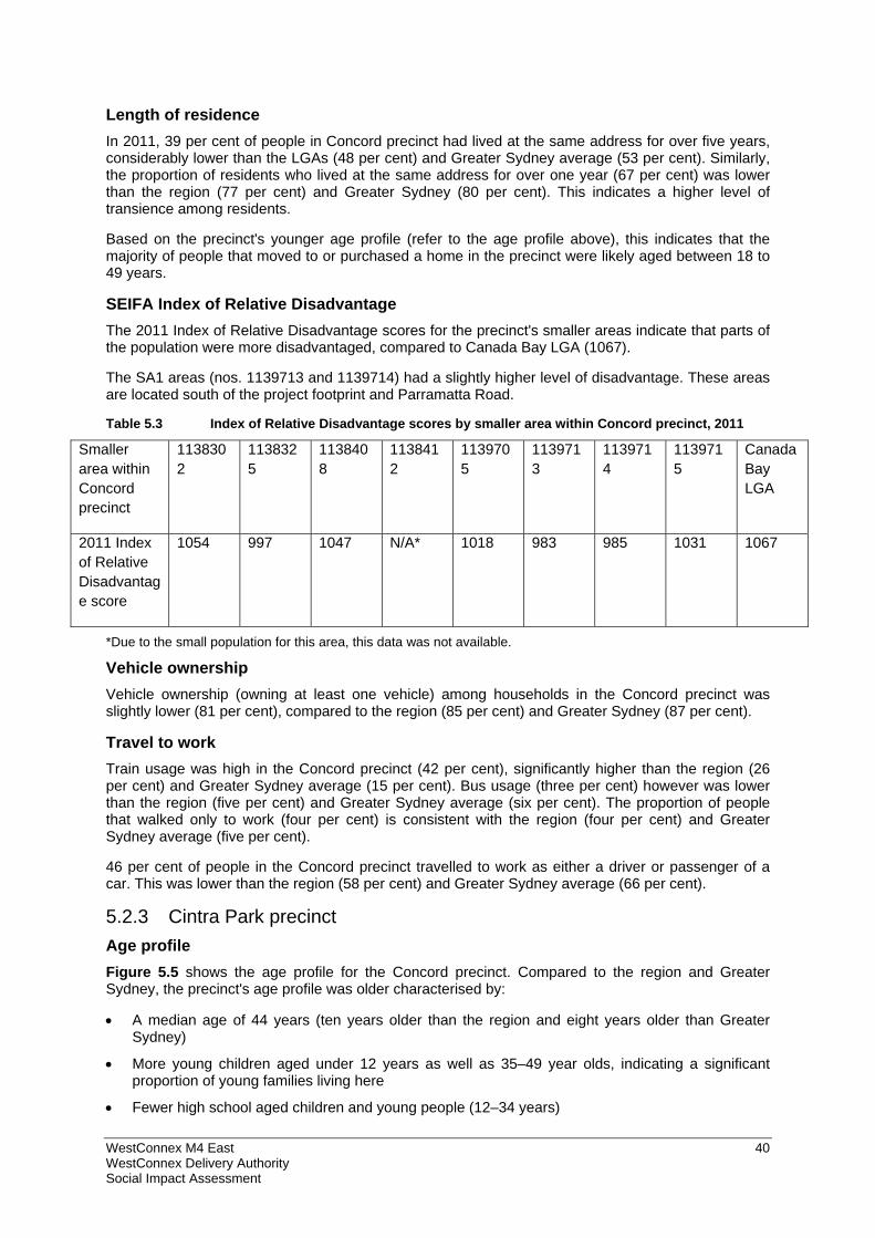
WestConnex M4 East 40 WestConnex Delivery Authority Social Impact Assessment
Length of residence In 2011, 39 per cent of people in Concord precinct had lived at the same address for over five years, considerably lower than the LGAs (48 per cent) and Greater Sydney average (53 per cent). Similarly, the proportion of residents who lived at the same address for over one year (67 per cent) was lower than the region (77 per cent) and Greater Sydney (80 per cent). This indicates a higher level of transience among residents.
Based on the precinct's younger age profile (refer to the age profile above), this indicates that the majority of people that moved to or purchased a home in the precinct were likely aged between 18 to 49 years.
SEIFA Index of Relative Disadvantage The 2011 Index of Relative Disadvantage scores for the precinct's smaller areas indicate that parts of the population were more disadvantaged, compared to Canada Bay LGA (1067).
The SA1 areas (nos. 1139713 and 1139714) had a slightly higher level of disadvantage. These areas are located south of the project footprint and Parramatta Road.
Table 5.3 Index of Relative Disadvantage scores by smaller area within Concord precinct, 2011
Smaller area within Concord precinct
1138302
1138325
1138408
1138412
1139705
1139713
1139714
1139715
Canada Bay LGA
2011 Index of Relative Disadvantage score
1054 997 1047 N/A* 1018 983 985 1031 1067
*Due to the small population for this area, this data was not available.
Vehicle ownership Vehicle ownership (owning at least one vehicle) among households in the Concord precinct was slightly lower (81 per cent), compared to the region (85 per cent) and Greater Sydney (87 per cent).
Travel to work Train usage was high in the Concord precinct (42 per cent), significantly higher than the region (26 per cent) and Greater Sydney average (15 per cent). Bus usage (three per cent) however was lower than the region (five per cent) and Greater Sydney average (six per cent). The proportion of people that walked only to work (four per cent) is consistent with the region (four per cent) and Greater Sydney average (five per cent).
46 per cent of people in the Concord precinct travelled to work as either a driver or passenger of a car. This was lower than the region (58 per cent) and Greater Sydney average (66 per cent).
5.2.3 Cintra Park precinct
Age profile Figure 5.5 shows the age profile for the Concord precinct. Compared to the region and Greater Sydney, the precinct's age profile was older characterised by:
A median age of 44 years (ten years older than the region and eight years older than Greater Sydney)
More young children aged under 12 years as well as 35–49 year olds, indicating a significant proportion of young families living here
Fewer high school aged children and young people (12–34 years)
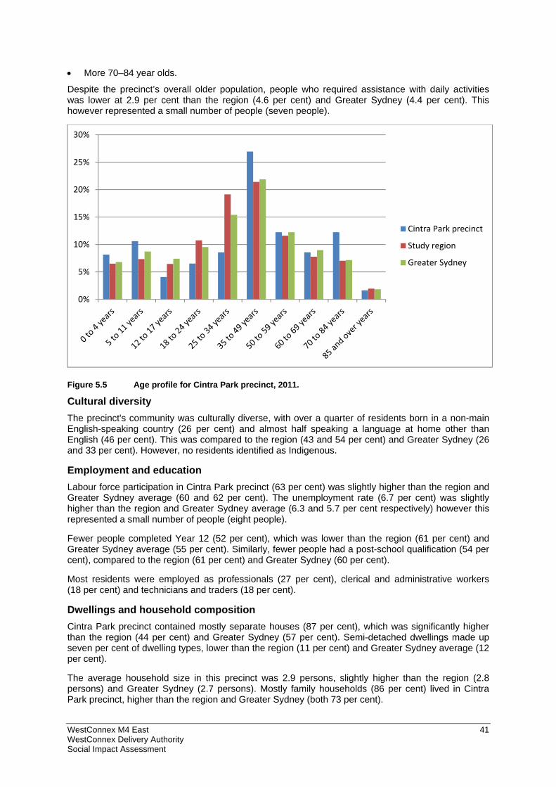
WestConnex M4 East 41 WestConnex Delivery Authority Social Impact Assessment
More 70–84 year olds.
Despite the precinct’s overall older population, people who required assistance with daily activities was lower at 2.9 per cent than the region (4.6 per cent) and Greater Sydney (4.4 per cent). This however represented a small number of people (seven people).
Figure 5.5 Age profile for Cintra Park precinct, 2011.
Cultural diversity The precinct's community was culturally diverse, with over a quarter of residents born in a non-main English-speaking country (26 per cent) and almost half speaking a language at home other than English (46 per cent). This was compared to the region (43 and 54 per cent) and Greater Sydney (26 and 33 per cent). However, no residents identified as Indigenous.
Employment and education Labour force participation in Cintra Park precinct (63 per cent) was slightly higher than the region and Greater Sydney average (60 and 62 per cent). The unemployment rate (6.7 per cent) was slightly higher than the region and Greater Sydney average (6.3 and 5.7 per cent respectively) however this represented a small number of people (eight people).
Fewer people completed Year 12 (52 per cent), which was lower than the region (61 per cent) and Greater Sydney average (55 per cent). Similarly, fewer people had a post-school qualification (54 per cent), compared to the region (61 per cent) and Greater Sydney (60 per cent).
Most residents were employed as professionals (27 per cent), clerical and administrative workers (18 per cent) and technicians and traders (18 per cent).
Dwellings and household composition Cintra Park precinct contained mostly separate houses (87 per cent), which was significantly higher than the region (44 per cent) and Greater Sydney (57 per cent). Semi-detached dwellings made up seven per cent of dwelling types, lower than the region (11 per cent) and Greater Sydney average (12 per cent).
The average household size in this precinct was 2.9 persons, slightly higher than the region (2.8 persons) and Greater Sydney (2.7 persons). Mostly family households (86 per cent) lived in Cintra Park precinct, higher than the region and Greater Sydney (both 73 per cent).
0%
5%
10%
15%
20%
25%
30%
Cintra Park precinct
Study region
Greater Sydney
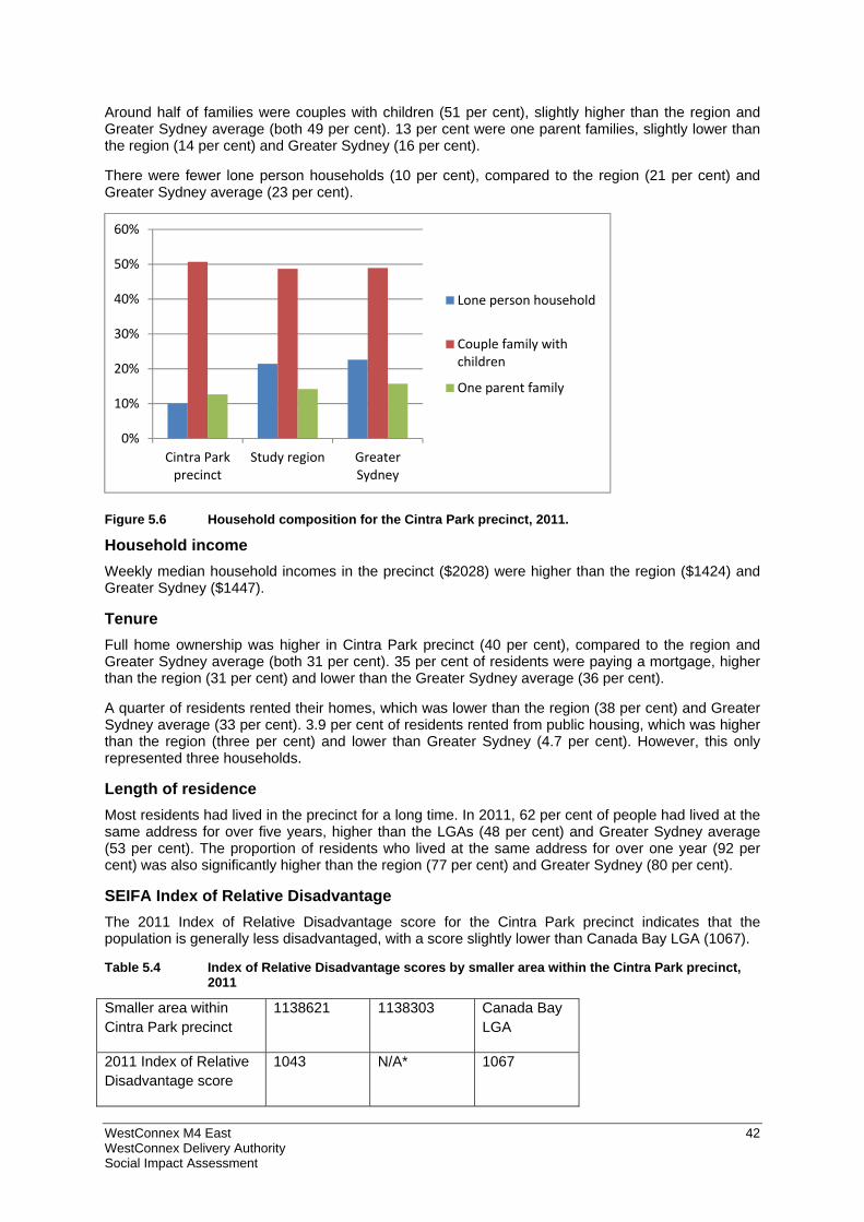
WestConnex M4 East 42 WestConnex Delivery Authority Social Impact Assessment
Around half of families were couples with children (51 per cent), slightly higher than the region and Greater Sydney average (both 49 per cent). 13 per cent were one parent families, slightly lower than the region (14 per cent) and Greater Sydney (16 per cent).
There were fewer lone person households (10 per cent), compared to the region (21 per cent) and Greater Sydney average (23 per cent).
Figure 5.6 Household composition for the Cintra Park precinct, 2011.
Household income Weekly median household incomes in the precinct ($2028) were higher than the region ($1424) and Greater Sydney ($1447).
Tenure Full home ownership was higher in Cintra Park precinct (40 per cent), compared to the region and Greater Sydney average (both 31 per cent). 35 per cent of residents were paying a mortgage, higher than the region (31 per cent) and lower than the Greater Sydney average (36 per cent).
A quarter of residents rented their homes, which was lower than the region (38 per cent) and Greater Sydney average (33 per cent). 3.9 per cent of residents rented from public housing, which was higher than the region (three per cent) and lower than Greater Sydney (4.7 per cent). However, this only represented three households.
Length of residence Most residents had lived in the precinct for a long time. In 2011, 62 per cent of people had lived at the same address for over five years, higher than the LGAs (48 per cent) and Greater Sydney average (53 per cent). The proportion of residents who lived at the same address for over one year (92 per cent) was also significantly higher than the region (77 per cent) and Greater Sydney (80 per cent).
SEIFA Index of Relative Disadvantage The 2011 Index of Relative Disadvantage score for the Cintra Park precinct indicates that the population is generally less disadvantaged, with a score slightly lower than Canada Bay LGA (1067).
Table 5.4 Index of Relative Disadvantage scores by smaller area within the Cintra Park precinct, 2011
Smaller area within Cintra Park precinct
1138621 1138303 Canada Bay LGA
2011 Index of Relative Disadvantage score
1043 N/A* 1067
0%
10%
20%
30%
40%
50%
60%
Cintra Parkprecinct
Study region GreaterSydney
Lone person household
Couple family withchildren
One parent family
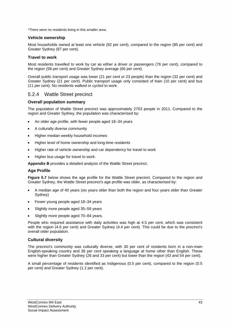
WestConnex M4 East 43 WestConnex Delivery Authority Social Impact Assessment
*There were no residents living in this smaller area.
Vehicle ownership Most households owned at least one vehicle (92 per cent), compared to the region (85 per cent) and Greater Sydney (87 per cent).
Travel to work Most residents travelled to work by car as either a driver or passengers (76 per cent), compared to the region (58 per cent) and Greater Sydney average (66 per cent).
Overall public transport usage was lower (21 per cent or 23 people) than the region (32 per cent) and Greater Sydney (21 per cent). Public transport usage only consisted of train (10 per cent) and bus (11 per cent). No residents walked or cycled to work.
5.2.4 Wattle Street precinct
Overall population summary The population of Wattle Street precinct was approximately 2703 people in 2011. Compared to the region and Greater Sydney, the population was characterised by:
An older age profile, with fewer people aged 18–34 years
A culturally diverse community
Higher median weekly household incomes
Higher level of home ownership and long-time residents
Higher rate of vehicle ownership and car dependency for travel to work
Higher bus usage for travel to work.
Appendix B provides a detailed analysis of the Wattle Street precinct.
Age Profile Figure 5.7 below shows the age profile for the Wattle Street precinct. Compared to the region and Greater Sydney, the Wattle Street precinct's age profile was older, as characterised by:
A median age of 40 years (six years older than both the region and four years older than Greater Sydney)
Fewer young people aged 18–34 years
Slightly more people aged 35–59 years
Slightly more people aged 70–84 years.
People who required assistance with daily activities was high at 4.5 per cent, which was consistent with the region (4.6 per cent) and Greater Sydney (4.4 per cent). This could be due to the precinct's overall older population.
Cultural diversity The precinct's community was culturally diverse, with 30 per cent of residents born in a non-main English-speaking country and 36 per cent speaking a language at home other than English. These were higher than Greater Sydney (26 and 33 per cent) but lower than the region (43 and 54 per cent).
A small percentage of residents identified as Indigenous (0.5 per cent), compared to the region (0.5 per cent) and Greater Sydney (1.2 per cent).
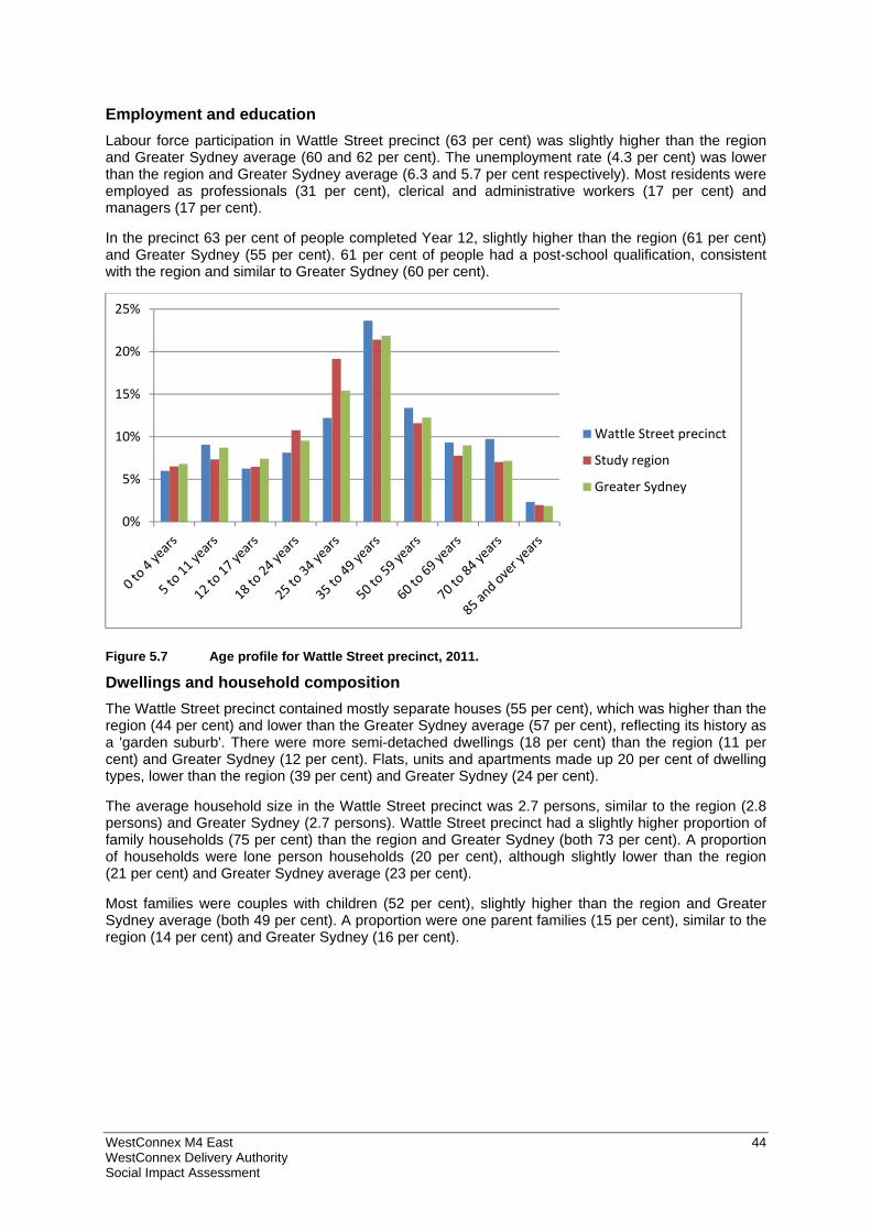
WestConnex M4 East 44 WestConnex Delivery Authority Social Impact Assessment
Employment and education Labour force participation in Wattle Street precinct (63 per cent) was slightly higher than the region and Greater Sydney average (60 and 62 per cent). The unemployment rate (4.3 per cent) was lower than the region and Greater Sydney average (6.3 and 5.7 per cent respectively). Most residents were employed as professionals (31 per cent), clerical and administrative workers (17 per cent) and managers (17 per cent).
In the precinct 63 per cent of people completed Year 12, slightly higher than the region (61 per cent) and Greater Sydney (55 per cent). 61 per cent of people had a post-school qualification, consistent with the region and similar to Greater Sydney (60 per cent).
Figure 5.7 Age profile for Wattle Street precinct, 2011.
Dwellings and household composition The Wattle Street precinct contained mostly separate houses (55 per cent), which was higher than the region (44 per cent) and lower than the Greater Sydney average (57 per cent), reflecting its history as a 'garden suburb'. There were more semi-detached dwellings (18 per cent) than the region (11 per cent) and Greater Sydney (12 per cent). Flats, units and apartments made up 20 per cent of dwelling types, lower than the region (39 per cent) and Greater Sydney (24 per cent).
The average household size in the Wattle Street precinct was 2.7 persons, similar to the region (2.8 persons) and Greater Sydney (2.7 persons). Wattle Street precinct had a slightly higher proportion of family households (75 per cent) than the region and Greater Sydney (both 73 per cent). A proportion of households were lone person households (20 per cent), although slightly lower than the region (21 per cent) and Greater Sydney average (23 per cent).
Most families were couples with children (52 per cent), slightly higher than the region and Greater Sydney average (both 49 per cent). A proportion were one parent families (15 per cent), similar to the region (14 per cent) and Greater Sydney (16 per cent).
0%
5%
10%
15%
20%
25%
Wattle Street precinct
Study region
Greater Sydney
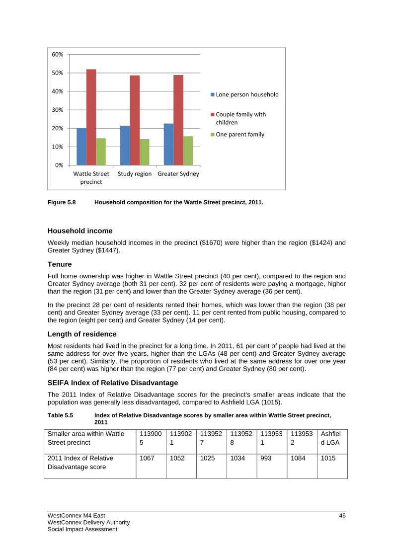
WestConnex M4 East 45 WestConnex Delivery Authority Social Impact Assessment
Figure 5.8 Household composition for the Wattle Street precinct, 2011.
Household income Weekly median household incomes in the precinct ($1670) were higher than the region ($1424) and Greater Sydney ($1447).
Tenure Full home ownership was higher in Wattle Street precinct (40 per cent), compared to the region and Greater Sydney average (both 31 per cent). 32 per cent of residents were paying a mortgage, higher than the region (31 per cent) and lower than the Greater Sydney average (36 per cent).
In the precinct 28 per cent of residents rented their homes, which was lower than the region (38 per cent) and Greater Sydney average (33 per cent). 11 per cent rented from public housing, compared to the region (eight per cent) and Greater Sydney (14 per cent).
Length of residence Most residents had lived in the precinct for a long time. In 2011, 61 per cent of people had lived at the same address for over five years, higher than the LGAs (48 per cent) and Greater Sydney average (53 per cent). Similarly, the proportion of residents who lived at the same address for over one year (84 per cent) was higher than the region (77 per cent) and Greater Sydney (80 per cent).
SEIFA Index of Relative Disadvantage The 2011 Index of Relative Disadvantage scores for the precinct's smaller areas indicate that the population was generally less disadvantaged, compared to Ashfield LGA (1015).
Table 5.5 Index of Relative Disadvantage scores by smaller area within Wattle Street precinct, 2011
Smaller area within Wattle Street precinct
1139005
1139021
1139527
1139528
1139531
1139532
Ashfield LGA
2011 Index of Relative Disadvantage score
1067 1052 1025 1034 993 1084 1015
0%
10%
20%
30%
40%
50%
60%
Wattle Streetprecinct
Study region Greater Sydney
Lone person household
Couple family withchildren
One parent family
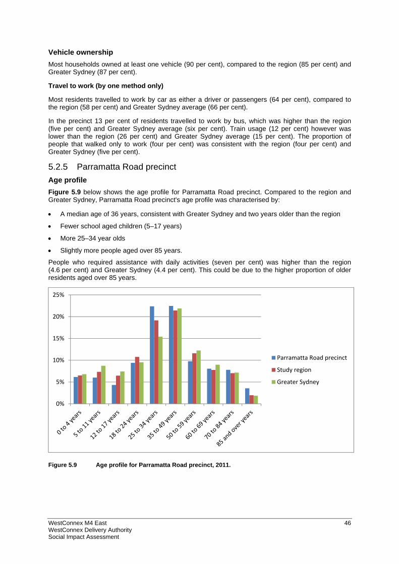
WestConnex M4 East 46 WestConnex Delivery Authority Social Impact Assessment
Vehicle ownership Most households owned at least one vehicle (90 per cent), compared to the region (85 per cent) and Greater Sydney (87 per cent).
Travel to work (by one method only)
Most residents travelled to work by car as either a driver or passengers (64 per cent), compared to the region (58 per cent) and Greater Sydney average (66 per cent).
In the precinct 13 per cent of residents travelled to work by bus, which was higher than the region (five per cent) and Greater Sydney average (six per cent). Train usage (12 per cent) however was lower than the region (26 per cent) and Greater Sydney average (15 per cent). The proportion of people that walked only to work (four per cent) was consistent with the region (four per cent) and Greater Sydney (five per cent).
5.2.5 Parramatta Road precinct
Age profile Figure 5.9 below shows the age profile for Parramatta Road precinct. Compared to the region and Greater Sydney, Parramatta Road precinct's age profile was characterised by:
A median age of 36 years, consistent with Greater Sydney and two years older than the region
Fewer school aged children (5–17 years)
More 25–34 year olds
Slightly more people aged over 85 years.
People who required assistance with daily activities (seven per cent) was higher than the region (4.6 per cent) and Greater Sydney (4.4 per cent). This could be due to the higher proportion of older residents aged over 85 years.
Figure 5.9 Age profile for Parramatta Road precinct, 2011.
0%
5%
10%
15%
20%
25%
Parramatta Road precinct
Study region
Greater Sydney
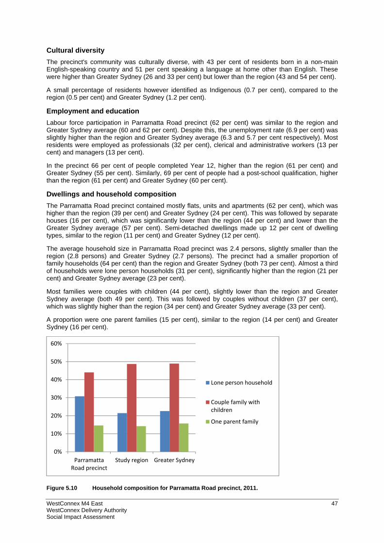
WestConnex M4 East 47 WestConnex Delivery Authority Social Impact Assessment
Cultural diversity The precinct's community was culturally diverse, with 43 per cent of residents born in a non-main English-speaking country and 51 per cent speaking a language at home other than English. These were higher than Greater Sydney (26 and 33 per cent) but lower than the region (43 and 54 per cent).
A small percentage of residents however identified as Indigenous (0.7 per cent), compared to the region (0.5 per cent) and Greater Sydney (1.2 per cent).
Employment and education Labour force participation in Parramatta Road precinct (62 per cent) was similar to the region and Greater Sydney average (60 and 62 per cent). Despite this, the unemployment rate (6.9 per cent) was slightly higher than the region and Greater Sydney average (6.3 and 5.7 per cent respectively). Most residents were employed as professionals (32 per cent), clerical and administrative workers (13 per cent) and managers (13 per cent).
In the precinct 66 per cent of people completed Year 12, higher than the region (61 per cent) and Greater Sydney (55 per cent). Similarly, 69 per cent of people had a post-school qualification, higher than the region (61 per cent) and Greater Sydney (60 per cent).
Dwellings and household composition The Parramatta Road precinct contained mostly flats, units and apartments (62 per cent), which was higher than the region (39 per cent) and Greater Sydney (24 per cent). This was followed by separate houses (16 per cent), which was significantly lower than the region (44 per cent) and lower than the Greater Sydney average (57 per cent). Semi-detached dwellings made up 12 per cent of dwelling types, similar to the region (11 per cent) and Greater Sydney (12 per cent).
The average household size in Parramatta Road precinct was 2.4 persons, slightly smaller than the region (2.8 persons) and Greater Sydney (2.7 persons). The precinct had a smaller proportion of family households (64 per cent) than the region and Greater Sydney (both 73 per cent). Almost a third of households were lone person households (31 per cent), significantly higher than the region (21 per cent) and Greater Sydney average (23 per cent).
Most families were couples with children (44 per cent), slightly lower than the region and Greater Sydney average (both 49 per cent). This was followed by couples without children (37 per cent), which was slightly higher than the region (34 per cent) and Greater Sydney average (33 per cent).
A proportion were one parent families (15 per cent), similar to the region (14 per cent) and Greater Sydney (16 per cent).
Figure 5.10 Household composition for Parramatta Road precinct, 2011.
0%
10%
20%
30%
40%
50%
60%
ParramattaRoad precinct
Study region Greater Sydney
Lone person household
Couple family withchildren
One parent family
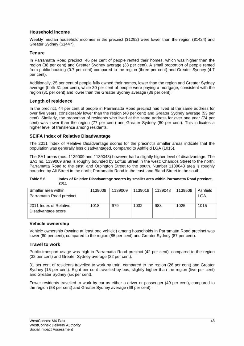
WestConnex M4 East 48 WestConnex Delivery Authority Social Impact Assessment
Household income Weekly median household incomes in the precinct ($1292) were lower than the region ($1424) and Greater Sydney ($1447).
Tenure In Parramatta Road precinct, 46 per cent of people rented their homes, which was higher than the region (38 per cent) and Greater Sydney average (33 per cent). A small proportion of people rented from public housing (0.7 per cent) compared to the region (three per cent) and Greater Sydney (4.7 per cent).
Additionally, 25 per cent of people fully owned their homes, lower than the region and Greater Sydney average (both 31 per cent), while 30 per cent of people were paying a mortgage, consistent with the region (31 per cent) and lower than the Greater Sydney average (36 per cent).
Length of residence In the precinct, 44 per cent of people in Parramatta Road precinct had lived at the same address for over five years, considerably lower than the region (48 per cent) and Greater Sydney average (53 per cent). Similarly, the proportion of residents who lived at the same address for over one year (74 per cent) was lower than the region (77 per cent) and Greater Sydney (80 per cent). This indicates a higher level of transience among residents.
SEIFA Index of Relative Disadvantage The 2011 Index of Relative Disadvantage scores for the precinct's smaller areas indicate that the population was generally less disadvantaged, compared to Ashfield LGA (1015).
The SA1 areas (nos. 1139009 and 1139043) however had a slightly higher level of disadvantage. The SA1 no. 1139009 area is roughly bounded by Loftus Street in the west; Chandos Street to the north; Parramatta Road to the east; and Orpington Street to the south. Number 1139043 area is roughly bounded by Alt Street in the north; Parramatta Road in the east; and Bland Street in the south.
Table 5.6 Index of Relative Disadvantage scores by smaller area within Parramatta Road precinct, 2011
Smaller area within Parramatta Road precinct
1139008 1139009 1139018 1139043 1139508 Ashfield LGA
2011 Index of Relative Disadvantage score
1018 979 1032 983 1025 1015
Vehicle ownership Vehicle ownership (owning at least one vehicle) among households in Parramatta Road precinct was lower (80 per cent), compared to the region (85 per cent) and Greater Sydney (87 per cent).
Travel to work Public transport usage was high in Parramatta Road precinct (42 per cent), compared to the region (32 per cent) and Greater Sydney average (22 per cent).
31 per cent of residents travelled to work by train, compared to the region (26 per cent) and Greater Sydney (15 per cent). Eight per cent travelled by bus, slightly higher than the region (five per cent) and Greater Sydney (six per cent).
Fewer residents travelled to work by car as either a driver or passenger (49 per cent), compared to the region (58 per cent) and Greater Sydney average (66 per cent).
WestConnex M4 East 49 WestConnex Delivery Authority Social Impact Assessment
5.3 Social infrastructure This SIA identifies key social infrastructure in the regional which could be impacted by the construction or operation of the project. These impacts could include changes to how they are used by the community, or how they are accessed.
Social infrastructure includes both the physical infrastructure (such as community facilities) and the non-physical infrastructure (such as services, programs and networks) which help individuals and communities to meet their social needs and enhance community wellbeing. Social infrastructure can be considered according to three broad categories:
Universal facilities and services – including libraries, education/training, health, open spaces, parks, sport and recreation, community centres, cultural facilities, and safety and emergency services
Life-stage targeted facilities and services – for children, young people and older people
Targeted facilities and services – for groups with distinct needs, such as families, people with a disability, Indigenous people, and people from culturally and linguistically diverse backgrounds.3
This section identifies social infrastructure roughly within 500 metres of the project alignment (including tunnels). Figure 5.11 shows this social infrastructure. A summary of these is provided below, with further descriptions provided in Appendix C.
It is important to note, that not all social infrastructure may be captured in this report. Information has been gathered through desktop research, site visits, information from Councils and information provided as part of community consultation. There may be some social infrastructure which is not identified at this stage but it is anticipated that Appendix C will be continually updated as part of the ongoing environmental planning and assessment process.
How people access social infrastructure is also key to how it is used. Each of the local Councils in the region indicated the importance of Parramatta Road and other arterial roads and associated congestion in effectively discouraging or limiting resident and visitor access across the region. This has implications for social infrastructure, for how people work, recreate and socialise. The nature of these access issues is discussed in sections 6.4 and 7.3.
3 Adapted from QLD Department of Infrastructure Implementation Guideline No. 5 – Social Infrastructure Planning (2009)
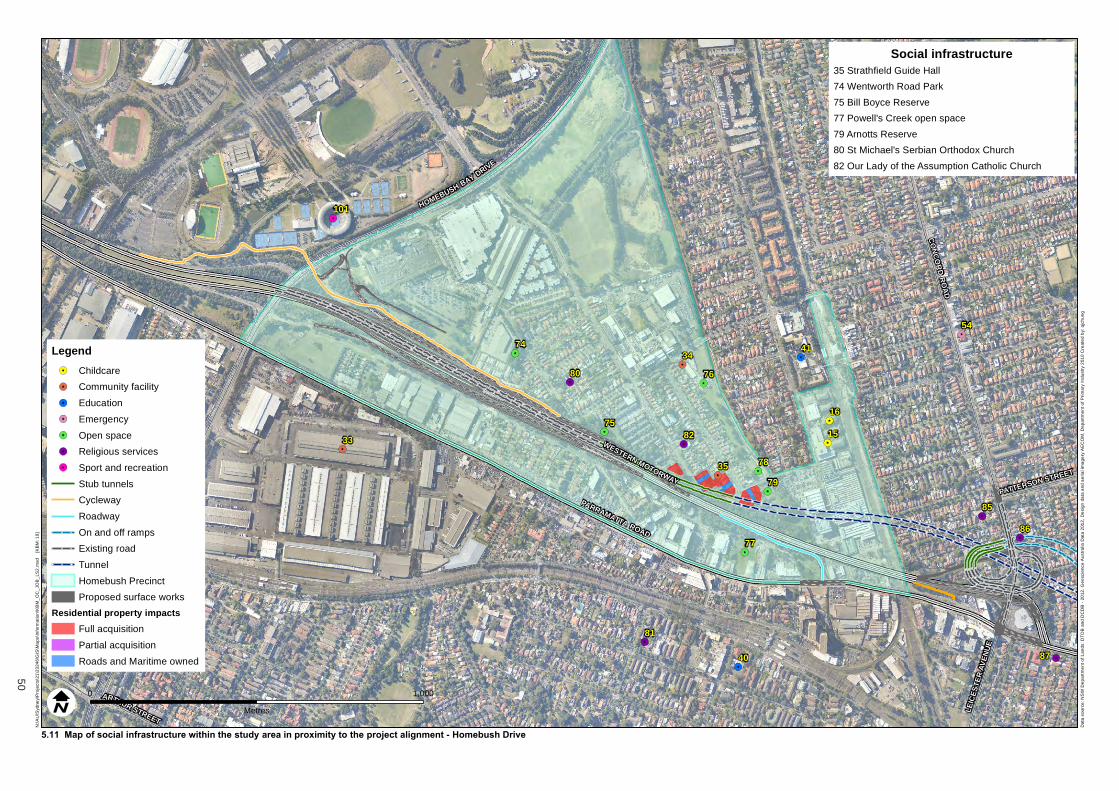
PATTERSON STREET
LEIC
ESTE
R AV
ENUE
ARTHUR STREET
CEN
TEN
ARY
DRIV
E
HOMEBUSH BAY DRIVE
CO
NC
OR
D R
OA
D
WESTERN MOTORWAY
PARRAMATTA ROAD
15
16
33
34
35
40
41
54
74
75
76
78
79
80
81
82
85
86
87
101
77
N:\A
U\S
ydne
y\P
roje
cts\
21\2
324
6\G
IS\M
aps
\Info
rmat
ion
\KB
M_
OC
_JO
B_
LS2
.mxd
[
KB
M: 1
9]
0 1,000
Metres
5.11 Map of social infrastructure within the study area in proximity to the project alignment - Homebush Drive
Dat
a so
urc
e: N
SW
De
par
tme
nt o
f L
ands
: DT
DB
an
d D
CD
B -
20
12. G
eosc
ienc
e A
ustr
alia
Dat
a 2
012
, De
sign
da
ta a
nd a
eria
l im
age
ry A
EC
OM
, D
epar
tme
nt o
f Pri
mar
y In
dus
try
201
0 C
reat
ed
by:
qjc
hun
g
LegendChildcare
Community facility
Education
Emergency
Open space
Religious services
Sport and recreation
Stub tunnels
Cycleway
Roadway
On and off ramps
Existing road
Tunnel
Homebush Precinct
Proposed surface works
Residential property impactsFull acquisition
Partial acquisition
Roads and Maritime owned
Social infrastructure35 Strathfield Guide Hall
74 Wentworth Road Park
75 Bill Boyce Reserve
77 Powell's Creek open space
79 Arnotts Reserve
80 St Michael's Serbian Orthodox Church
82 Our Lady of the Assumption Catholic Church
50
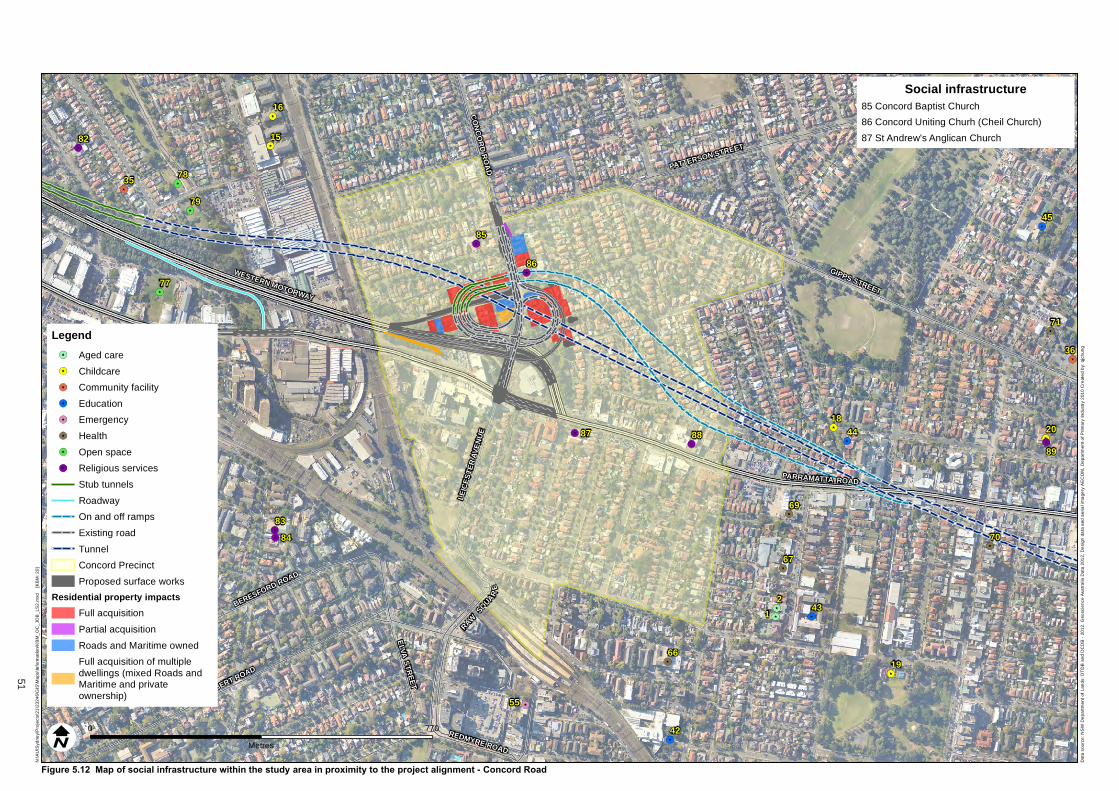
BROUGHTON ROAD
ALBERT ROAD
ELVA STREET
REDMYRE ROAD
BERESFORD ROAD
PATTERSON STREET
GIPPS STREET
LEIC
ESTE
R AV
ENUE
RAWSQUAR
E
CO
NC
OR
D R
OA
D
WESTERN MOTORWAY
PARRAMATTA ROAD
12
15
16
18
19
20
35
36
40
42
43
44
45
55
66
67
69
70
71
78
79
82
83
84
85
86
87 88
89
77
N:\A
U\S
ydne
y\P
roje
cts\
21\2
324
6\G
IS\M
aps
\Info
rmat
ion
\KB
M_
OC
_JO
B_
LS2
.mxd
[
KB
M: 2
0]
0 770
Metres
Figure 5.12 Map of social infrastructure within the study area in proximity to the project alignment - Concord Road
Dat
a so
urc
e: N
SW
De
par
tme
nt o
f L
ands
: DT
DB
an
d D
CD
B -
20
12. G
eosc
ienc
e A
ustr
alia
Dat
a 2
012
, De
sign
da
ta a
nd a
eria
l im
age
ry A
EC
OM
, D
epar
tme
nt o
f Pri
mar
y In
dus
try
201
0 C
reat
ed
by:
qjc
hun
g
LegendAged care
Childcare
Community facility
Education
Emergency
Health
Open space
Religious services
Stub tunnels
Roadway
On and off ramps
Existing road
Tunnel
Concord Precinct
Proposed surface works
Residential property impactsFull acquisition
Partial acquisition
Roads and Maritime owned
Full acquisition of multipledwellings (mixed Roads andMaritime and privateownership)
Social infrastructure85 Concord Baptist Church
86 Concord Uniting Churh (Cheil Church)
87 St Andrew's Anglican Church
X-X
51
PATTERSON STREET
QUEENS ROAD
GIPPS STREET
PARRAMATTA ROAD
1
2
317
18
19
20
21
22
36
43
44
45
46
47
49
58
59
67
69
70
71
72
89
90
102104
105
103
N:\A
U\S
ydne
y\P
roje
cts\
21\2
324
6\G
IS\M
aps
\Info
rmat
ion
\KB
M_
OC
_JO
B_
LS2
.mxd
[
KB
M: 2
1]
0 770
Metres
Figure 5.13 Map of social infrastructure within the study area in proximity to the project alignment - Cintra Park
Dat
a so
urc
e: N
SW
De
par
tme
nt o
f L
ands
: DT
DB
an
d D
CD
B -
20
12. G
eosc
ienc
e A
ustr
alia
Dat
a 2
012
, De
sign
da
ta a
nd a
eria
l im
age
ry A
EC
OM
, D
epar
tme
nt o
f Pri
mar
y In
dus
try
201
0 C
reat
ed
by:
qjc
hun
g
LegendAged care
Childcare
Community facility
Education
Emergency
Health
Religious services
Sport and recreation
On and off ramps
Tunnel
Ventilation shaft
Cintra Park Precinct
Social infrastructure102 Concord Oval
103 St Luke's Park
104 Cintra Hockey Complex
52
RAMSAY STREET
GR
EAT
NO
RTH
RO
AD
FREDERICK STREET
WATTLE STREET
DOBROYD PARADE
CITY-WEST LINK ROAD
RAM
SAYR
OA
D
FAIRLIGHT STREET
QUEENS ROAD
PARRAMATTAROAD
3
4
6
22
24
25
2627
28
30
31
3238
39
49
50
51
52
53
60
64
73
91
92
93
98
99 100
106
108
110
37
N:\A
U\S
ydne
y\P
roje
cts\
21\2
324
6\G
IS\M
aps
\Info
rmat
ion
\KB
M_
OC
_JO
B_
LS2
.mxd
[
KB
M: 2
2]
0 770
Metres
Figure 5.14 Map of social infrastructure within the study area in proximity to the project alignment - Wattle Street
Dat
a so
urc
e: N
SW
De
par
tme
nt o
f L
ands
: DT
DB
an
d D
CD
B -
20
12. G
eosc
ienc
e A
ustr
alia
Dat
a 2
012
, De
sign
da
ta a
nd a
eria
l im
age
ry A
EC
OM
, D
epar
tme
nt o
f Pri
mar
y In
dus
try
201
0 C
reat
ed
by:
qjc
hun
gLegendAged care
Childcare
Community facility
Education
Emergency
Health
Religious services
Sport and recreation
Stub tunnels
On and off ramps
Existing road
Tunnel
Wattle Street Precinct
Proposed surface works
Residential property impacts
Full acquisition
Partial acquisition
Roads and Maritime owned
Full acquisition of multipledwellings (mixed Roads andMaritime and privateownership)
Social infrastructure25 The Infants Home
93 Jehovah's Witnesses Kingdom Halls
108 Reg Coady Reserve
X-X
53