Embed Size (px)
Citation preview
Module 5: ESC Plan Elements Page | 1
Module 5: Erosion and Sediment Control Plan Elements
5. ESC plan elements…………………………………………………………………………………………..2
Reading Contour Intervals..……………………………………………………………………………..5
Adequate Plan………………....……………………………………………………………………………..9
Module 5: ESC Plan Elements Page | 2
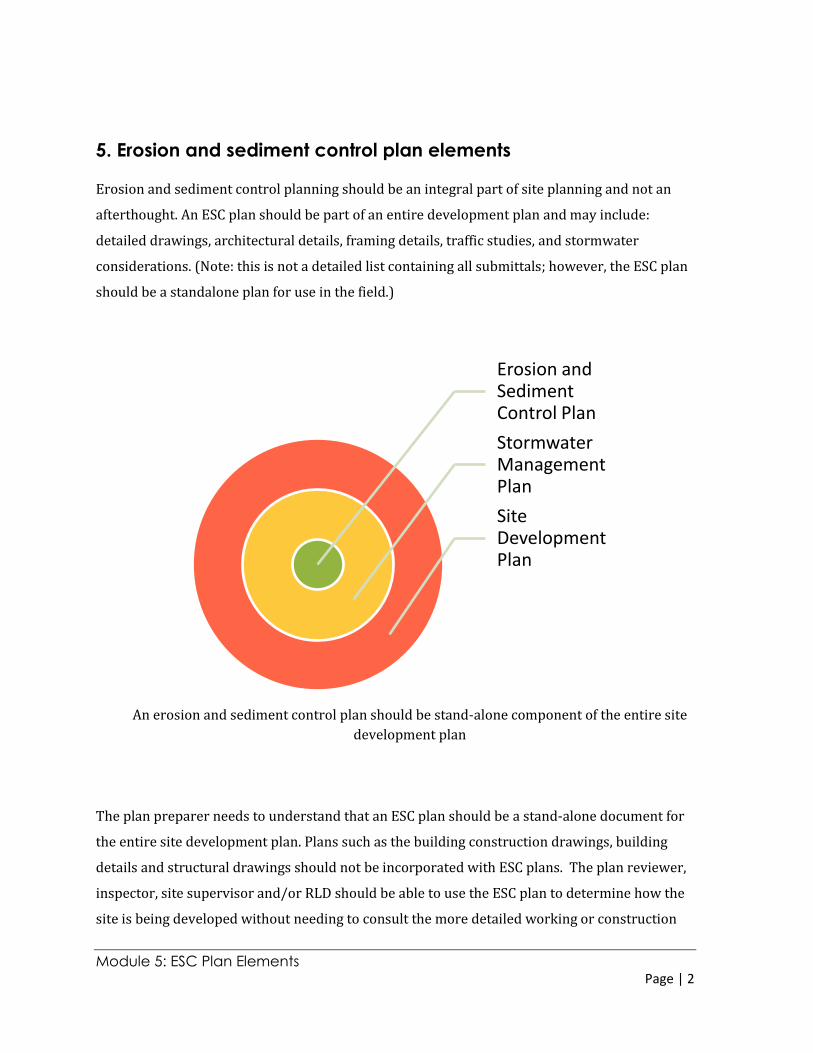
An erosion and sediment control plan should be stand-alone component of the entire site
development plan
5. Erosion and sediment control plan elements
Erosion and sediment control planning should be an integral part of site planning and not an
afterthought. An ESC plan should be part of an entire development plan and may include:
detailed drawings, architectural details, framing details, traffic studies, and stormwater
considerations. (Note: this is not a detailed list containing all submittals; however, the ESC plan
should be a standalone plan for use in the field.)
The plan preparer needs to understand that an ESC plan should be a stand-alone document for
the entire site development plan. Plans such as the building construction drawings, building
details and structural drawings should not be incorporated with ESC plans. The plan reviewer,
inspector, site supervisor and/or RLD should be able to use the ESC plan to determine how the
site is being developed without needing to consult the more detailed working or construction
Erosion and Sediment Control Plan
Stormwater Management Plan
Site Development Plan
Module 5: ESC Plan Elements Page | 3
Written portion or narrative
Illustrative portion or
plan
ESC Plan
drawings. The ESC plan should illustrate how the site is being developed, what is being
proposed for the site and the sequencing or phasing of the construction. The ESC plan should
not be bogged down with details that might not be relevant to erosion and sediment control.
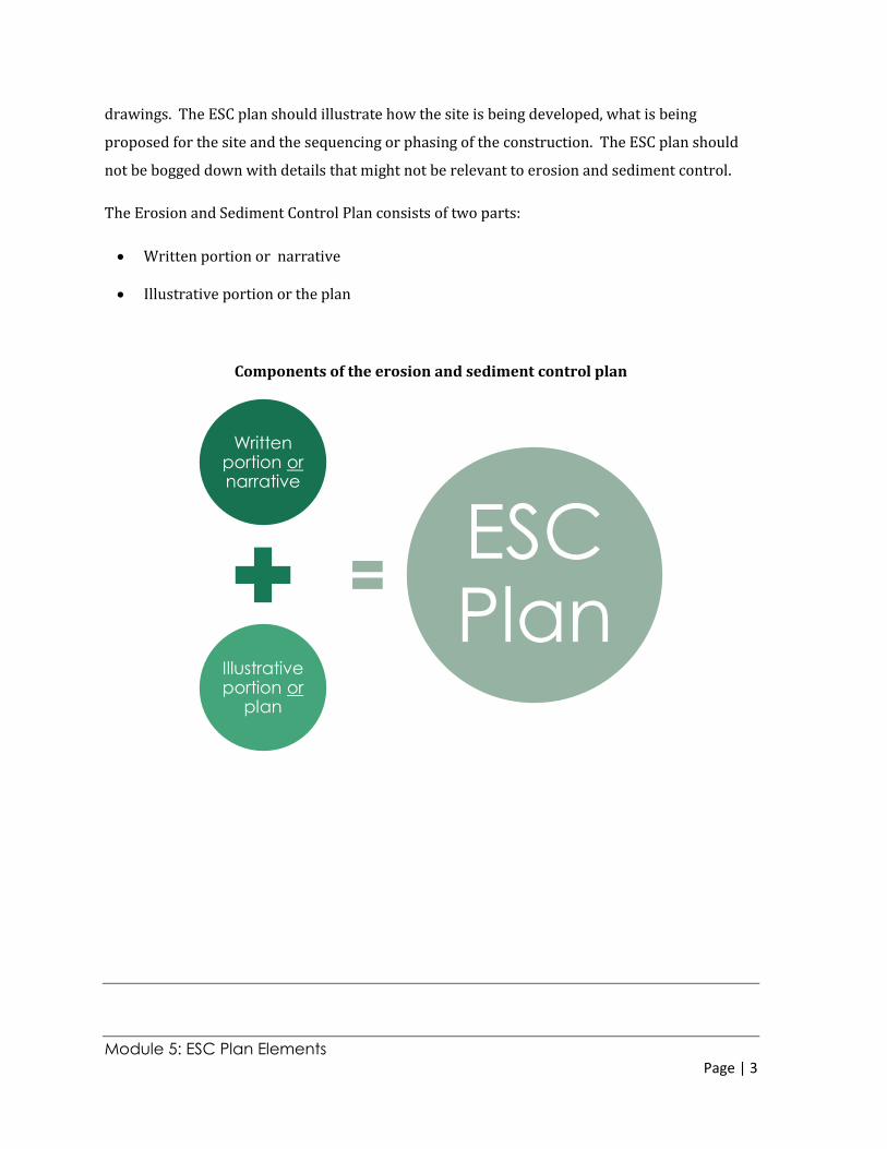
The Erosion and Sediment Control Plan consists of two parts:
Written portion or narrative
Illustrative portion or the plan
Components of the erosion and sediment control plan
Module 5: ESC Plan Elements Page | 4
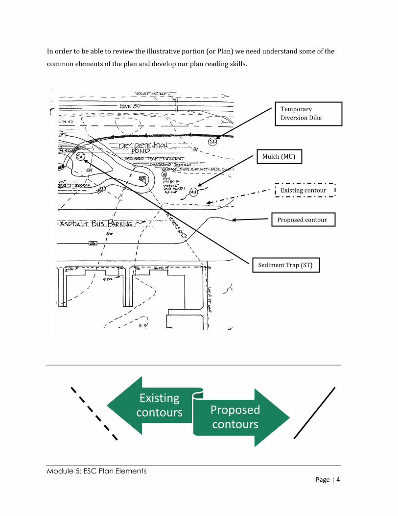
In order to be able to review the illustrative portion (or Plan) we need understand some of the
common elements of the plan and develop our plan reading skills.
Existing contours Proposed
contours
Temporary
Diversion Dike
(DD)
Mulch (MU)
Sediment Trap (ST)
Existing contour
Proposed contour
Module 5: ESC Plan Elements Page | 5
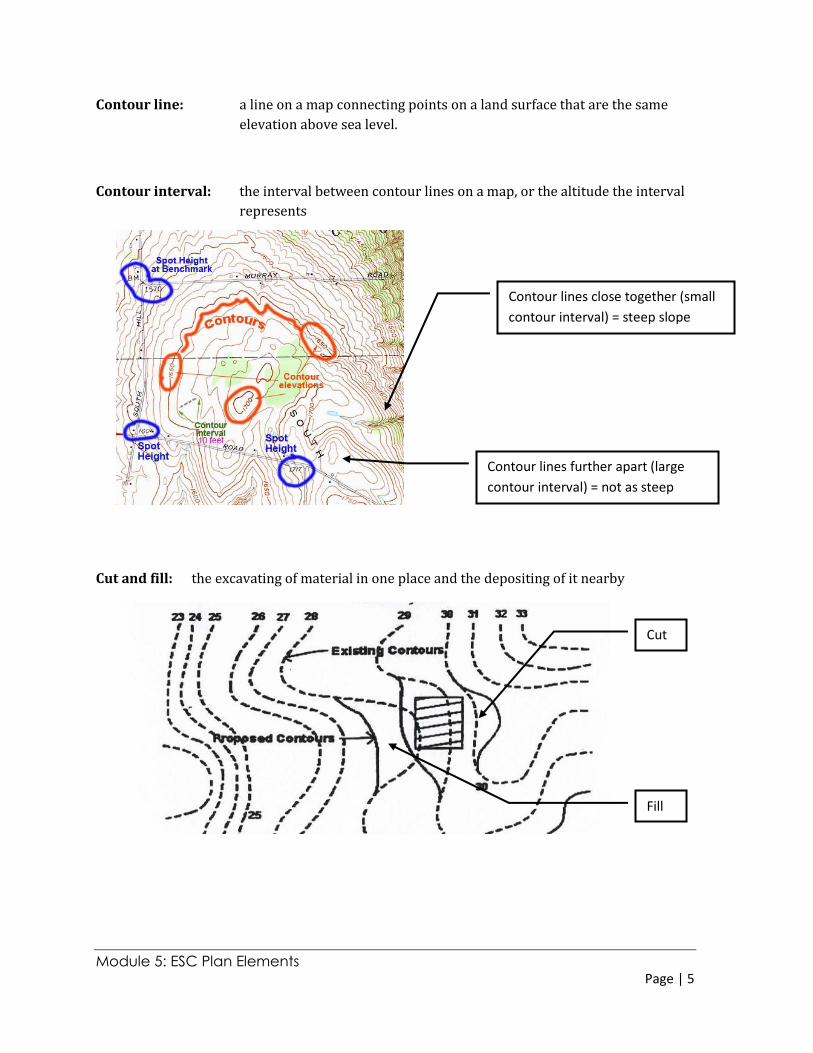
Contour line: a line on a map connecting points on a land surface that are the same
elevation above sea level.
Contour interval: the interval between contour lines on a map, or the altitude the interval
represents
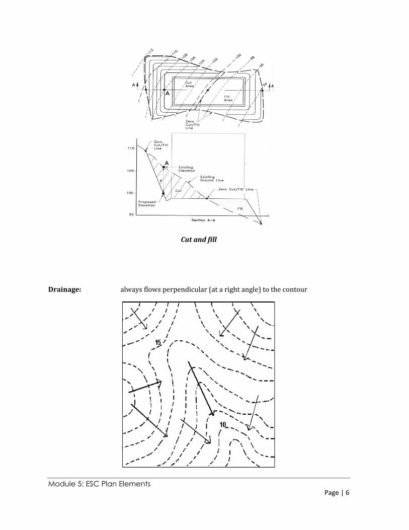
Cut and fill: the excavating of material in one place and the depositing of it nearby
Contour lines close together (small
contour interval) = steep slope
Contour lines further apart (large
contour interval) = not as steep
Cut
Fill
Module 5: ESC Plan Elements Page | 6
Cut and fill
Drainage: always flows perpendicular (at a right angle) to the contour
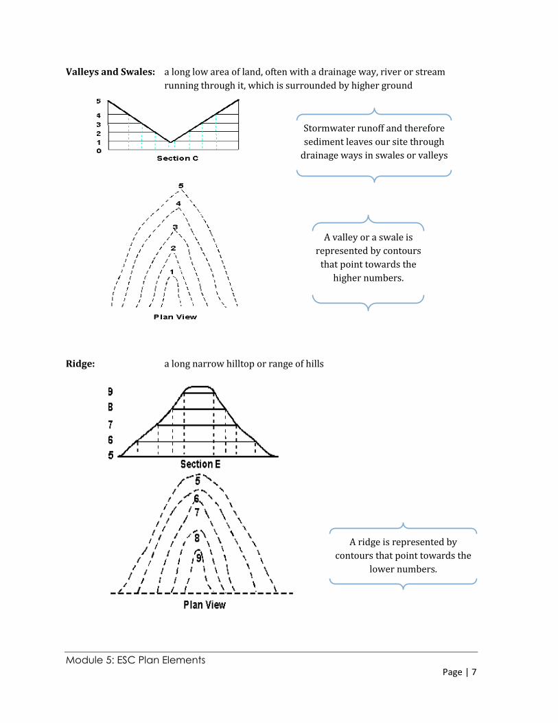
Module 5: ESC Plan Elements Page | 7
Stormwater runoff and therefore
sediment leaves our site through
drainage ways in swales or valleys
A valley or a swale is
represented by contours
that point towards the
higher numbers.
A ridge is represented by
contours that point towards the
lower numbers.
Valleys and Swales: a long low area of land, often with a drainage way, river or stream
running through it, which is surrounded by higher ground
Ridge: a long narrow hilltop or range of hills
Module 5: ESC Plan Elements Page | 8
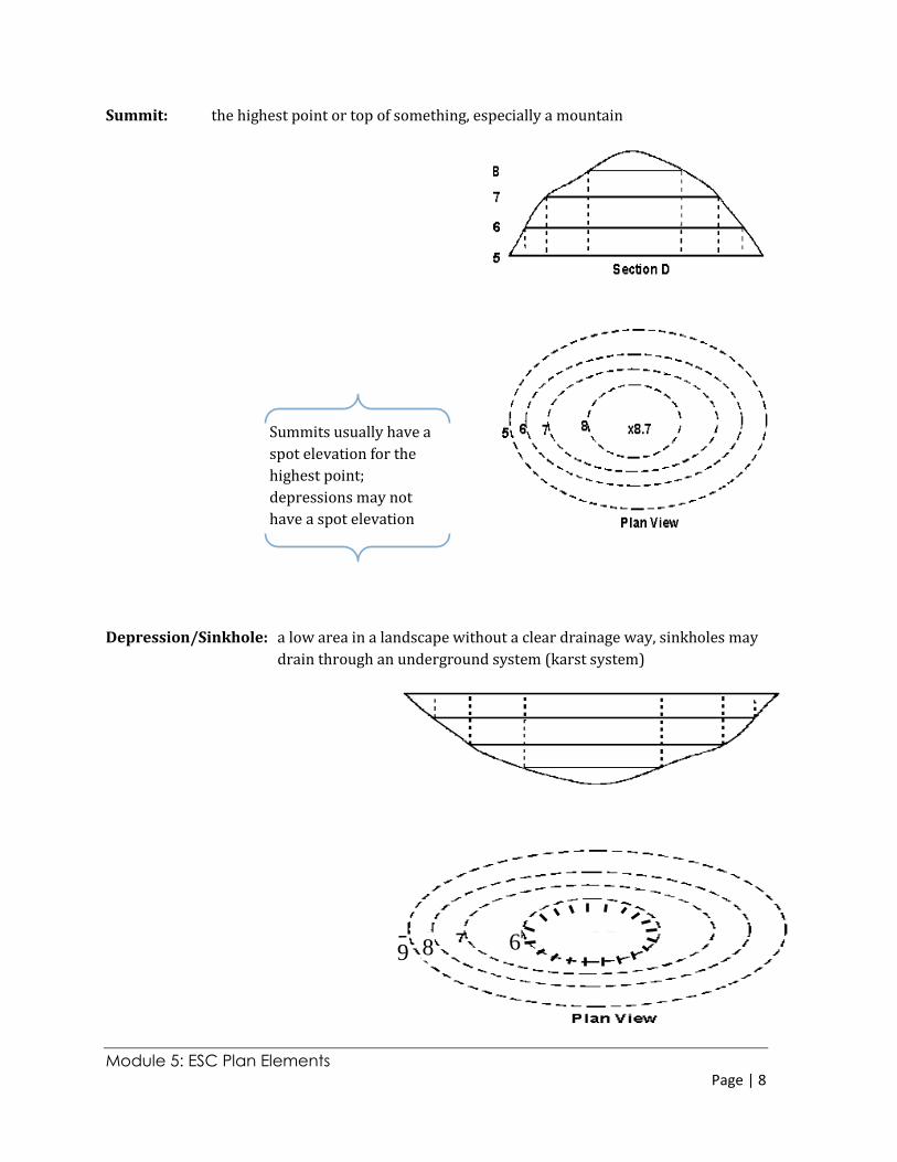
9 8 6
Summits usually have a
spot elevation for the
highest point;
depressions may not
have a spot elevation
Summit: the highest point or top of something, especially a mountain
Depression/Sinkhole: a low area in a landscape without a clear drainage way, sinkholes may
drain through an underground system (karst system)
Module 5: ESC Plan Elements Page | 9
Note: new, innovative and/or
proprietary practices may also
be used; however, these
practices need to be
thoroughly described to the
satisfaction of the plan
approving authority
What is an “Adequate” Plan?
A plan must contain enough information to satisfy the plan
approving authority that the problems of erosion and
sediment control have been adequately addressed.
An adequate plan will meet the following criteria:
The requirements of the Virginia Erosion and Sediment
Control Regulations in particular the minimum standards,
unless a variance has been applied for and has been
granted
Any more stringent standards applicable to the locality;
The standards and specifications published in the Erosion and Sediment Control Handbook
(ESCH)(Chapter 3)
It contains sufficient information to ensure the plan approving authority potential problems
of erosion and sedimentation have been adequately addressed
Whatever practices are used they need to titled, numbered and drawn as shown in the ESCH.