Embed Size (px)
Citation preview
ND
Ward
Dunn
Cass
Grant
McLeanMcKenzie
Morton
Williams
Stark
Stutsman
Wells
Kidder
Slope
McHenry
Barnes
MountrailWalsh
Divide
Burleigh
Sioux
Burke
Benson
Cavalier
Traill
Bottineau
Emmons
Pierce
Dickey
Richland
Billings
Logan
Mercer
Ramsey
Nelson
Towner
AdamsBowman
Rolette
LaMoure
Pembina
Eddy
Oliver
Hettinger
Grand Forks
SteeleSheridan
Renville
SargentMcIntosh
Griggs
Ransom
Foster
GoldenValley
INFR
AST
RU
CTU
RE
& D
RIV
ER B
EHAV
IOR
TR0119151018SEA
North Dakota
Local Road Safety Program
April 2015
Turtle MountainBand of Chippewa Indians
TR0119151018SEA
North Dakota Local Road Safety Program
Prepared by CH2M HILL
SRF Consulting Group, Inc.
On behalf of
North Dakota Department of Transportation
Grant Levi, P.E., Director
April 2015
23 USC 409
NDDOT Reserves All Objections
LOCAL ROAD SAFETY PROGRAM APRIL 2015 CONTENTS
TR0119151018SEA ii 23 USC 409: NDDOT Reserves All Objections
Contents
Executive Summary ............................................................................................................................ ES-1
1.0 Introduction ............................................................................................................................... 1-1 1.1 Background ......................................................................................................................... 1-1 1.2 Traffic Safety – A National Perspective .......................................................................... 1-2 1.2.1 AASHTO’s Strategic Highway Safety Plan and Safety Emphasis Areas ......... 1-3 1.3 North Dakota’s Statewide Safety Planning Efforts ....................................................... 1-3 1.4 Local Road Safety Program Overview ............................................................................ 1-5
2.0 Turtle Mountain Safety Emphasis Areas and Crash Overview ....................................... 2-1 2.1 Turtle Mountain Crash Overview ................................................................................... 2-1 2.1.1 North Dakota Crash Mapping ............................................................................ 2-1 2.1.2 Facilities Analyzed ................................................................................................ 2-1 2.1.3 Crash Data Sets ..................................................................................................... 2-1 2.2 Turtle Mountain Safety Emphasis Areas ........................................................................ 2-5 2.3 Crash Risk Factors ............................................................................................................. 2-6 2.3.1 Rural Roadway Segments – Crashes on Paved Roads .................................... 2-6 2.3.2 Rural Curves – Crashes on Paved Roads in Curves ...................................... 2-11 2.3.3 Rural Intersections – Crashes at Thru-STOP Intersections ........................... 2-14 2.4 Turtle Mountain Risk Summary .................................................................................... 2-18
3.0 Turtle Mountain Priority Safety Strategies .......................................................................... 3-1 3.1 Background ......................................................................................................................... 3-1 3.2 Initial/Comprehensive List of Potential Strategies ....................................................... 3-1 3.3 Prioritizing Safety Strategies ............................................................................................ 3-1 3.4 Safety Strategies Workshop .............................................................................................. 3-5
4.0 Turtle Mountain Infrastructure Safety Projects .................................................................. 4-1 4.1 Turtle Mountain Proactive Project Decision Process .................................................... 4-1 4.2 Turtle Mountain Project Summary .................................................................................. 4-7 5.0 Behavioral Safety Strategies ................................................................................................... 5-1 5.1 Purpose of Driver Behavior Safety Strategies ................................................................ 5-1 5.2 Overview of Behavioral Crash Data for Turtle Mountain ........................................... 5-1 5.3 Importance of Traffic Safety Culture Change ................................................................ 5-2 5.3.1 The Influence of Traffic Safety Culture .............................................................. 5-2 5.3.2 Social Norms Inhibiting a Strong Traffic Safety Culture ................................ 5-2 5.3.3 Social Levels Influencing Safety Culture ........................................................... 5-3 5.4 Behavioral Safety Strategies ............................................................................................. 5-4 5.4.1 Role of Policy, Education, and Enforcement ..................................................... 5-4 5.4.2 Effective Use of Public Information Strategies ................................................. 5-4 5.4.3 Turtle Mountain’s Priority Strategies................................................................. 5-5 5.4.4 Impaired Driving .................................................................................................. 5-6 5.4.5 Speeding and Aggressive Driving .................................................................... 5-15 5.4.6 Young Drivers ..................................................................................................... 5-19 5.4.7 Unbelted Occupants ........................................................................................... 5-23
LOCAL ROAD SAFETY PROGRAM APRIL 2015 CONTENTS
TR0119151018SEA iii 23 USC 409: NDDOT Reserves All Objections
5.4.8 Cross-Cutting Safety Strategy ........................................................................... 5-25 5.5 Traffic Safety Office Supporting Resources ................................................................. 5-26 5.5.1 TSO Grant Program Application Process ........................................................ 5-26 5.5.2 Technical Assistance ........................................................................................... 5-26 5.5.3 Traffic Records/Crash Data .............................................................................. 5-27 References ................................................................................................................................. 5-28
LOCAL ROAD SAFETY PROGRAM APRIL 2015 ACRONYMS AND ABBREVIATIONS
TR0119151018SEA iv 23 USC 409: NDDOT Reserves All Objections
Acronyms and Abbreviations
4Es education, enforcement, engineering, and emergency medical services
100MVMT 100 million vehicle miles traveled
AASHTO American Association of State Highway and Transportation Officials
ADT average daily traffic
CMC county major collector
CMF crash modification factor
CRS Crash Reporting System (North Dakota Department of Transportation)
DUI driving under the influence
EMS emergency medical services
ERA edge risk assessment
FHWA Federal Highway Administration
GDL graduated driver’s license
GHSA Governors Highway Safety Association
HSIP Highway Safety Improvement Program
LEAD Listen, Educate, Ask, Discuss
LRSP Local Road Safety Program
MUTCD Manual on Uniform Traffic Control Devices
NCHRP National Cooperative Highway Research Program
NDDOT North Dakota Department of Transportation
NHTSA National Highway Traffic Safety Administration
Plan LRSP Safety Plan
PSA public service announcement
SHSP Strategic Highway Safety Plan
TSO Traffic Safety Office
TR0119151018SEA ES-1 23 USC 409: NDDOT Reserves All Objections
Executive Summary
This Local Road Safety Program (LRSP) Plan (Plan) was prepared for Turtle Mountain as part of North Dakota’s statewide highway safety planning process. The contents are the result of a data-driven process, with a goal to reduce severe crashes (defined as those crashes resulting in at least one fatality or incapacitating injury) by documenting at-risk locations, identifying effective low-cost safety improvement strategies, and better positioning local agencies to compete for available safety funds. The LRSP includes a description of the connection to safety planning efforts at the national, state (through North Dakota’s Strategic Highway Safety Plan and the Highway Safety Improvement Program), and regional levels.
This LRSP was commissioned by the North Dakota Department of Transportation (NDDOT) to provide a tool to assist counties, cities and Indian reservations in submitting proactive low-cost systemic safety projects for the NDDOT to fund as part of the Highway Safety Improvement Program (HSIP). The LRSP is not intended to be a complete safety plan for Turtle Mountain, because there may be other safety improvement strategies that are considered high-cost or low-cost that are also effective, but cannot be systemically applied across a local road system. While this LRSP addresses many of the safety concerns at high-risk locations within the Turtle Mountain Reservation, other equally important projects may be identified after this safety planning effort is complete.
Specifically, this LRSP includes the following:
Description of the safety emphasis areas.
Identification of a short list of high-priority, low-cost safety strategies.
Documentation of at-risk locations along the local road systems that are considered candidates for safety investment. At-risk locations include roadway segments, horizontal curves, and intersections with multiple severe crashes or with roadway geometry and traffic characteristics similar to other locations in North Dakota where severe crashes have occurred.
Development of approximately $1 million of suggested safety projects across the reservation (Table ES-1), including the filled out forms suitable for submittal to the NDDOT for their consideration for HSIP funding. These projects represent the application of high-priority safety strategies at the at-risk locations.
Discussion of behavioral crash statistics, potential safety strategies, and current statewide resources available for implementation of behavioral safety strategies.
LOCAL ROAD SAFETY PROGRAM APRIL 2015 EXECUTIVE SUMMARY
TR0119151018SEA ES-2 23 USC 409: NDDOT Reserves All Objections
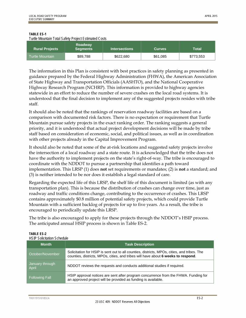
TABLE ES-1 Turtle Mountain Total Safety Project Estimated Costs
Rural Projects Roadway Segments Intersections Curves Total
Turtle Mountain $89,788 $622,680 $61,085 $773,553
The information in this Plan is consistent with best practices in safety planning as presented in guidance prepared by the Federal Highway Administration (FHWA), the American Association of State Highway and Transportation Officials (AASHTO), and the National Cooperative Highway Research Program (NCHRP). This information is provided to highway agencies statewide in an effort to reduce the number of severe crashes on the local road systems. It is understood that the final decision to implement any of the suggested projects resides with tribe staff.
It should also be noted that the rankings of reservation roadway facilities are based on a comparison with documented risk factors. There is no expectation or requirement that Turtle Mountain pursue safety projects in the exact ranking order. The ranking suggests a general priority, and it is understood that actual project development decisions will be made by tribe staff based on consideration of economic, social, and political issues, as well as in coordination with other projects already in the Capital Improvement Program.
It should also be noted that some of the at-risk locations and suggested safety projects involve the intersection of a local roadway and a state route. It is acknowledged that the tribe does not have the authority to implement projects on the state’s right-of-way. The tribe is encouraged to coordinate with the NDDOT to pursue a partnership that identifies a path toward implementation. This LRSP (1) does not set requirements or mandates; (2) is not a standard; and (3) is neither intended to be nor does it establish a legal standard of care.
Regarding the expected life of this LRSP, the shelf life of this document is limited (as with any transportation plan). This is because the distribution of crashes can change over time, just as roadway and traffic conditions change, contributing to the occurrence of crashes. This LRSP contains approximately $0.8 million of potential safety projects, which could provide Turtle Mountain with a sufficient backlog of projects for up to five years. As a result, the tribe is encouraged to periodically update this LRSP.
The tribe is also encouraged to apply for these projects through the NDDOT’s HSIP process. The anticipated annual HSIP process is shown in Table ES-2.
TABLE ES-2 HSIP Solicitation Schedule
Month Task Description
October/November Solicitation for HSIP is sent out to all counties, districts, MPOs, cities, and tribes. The counties, districts, MPOs, cities, and tribes will have about 6 weeks to respond.
January through April
NDDOT reviews the requests and conducts additional studies if required.
Following Fall HSIP approval notices are sent after program concurrence from the FHWA. Funding for an approved project will be provided as funding is available.
TR0119151018SEA 1-1 23 USC 409: NDDOT Reserves All Objections
1.0 Introduction
1.1 Background To fulfill a commitment in the 2013 North Dakota Strategic Highway Safety Plan (SHSP), the North Dakota Department of Transportation (NDDOT) began the Local Road Safety Program (LRSP). The purpose of the LRSP is to better engage local roadway agencies in the statewide safety planning process. The NDDOT’s commitment is based on two pieces of information:
Based on 2007-to-2011 crash records, the SHSP identified that 56 percent of severe crashes (those crashes resulting in at least one fatality or incapacitating injury) in North Dakota occurred on roads operated by local agencies. (Note: More recent crash data from 2009 to 2013 indicates that 44 percent of severe crashes were on local agency roads.)
The NDDOT had historically focused federal safety funds on interstates, U.S. highways, and state highways, even though slightly more than half of severe crashes occurred on those facilities.
The NDDOT set out to increase the level of participation of local agencies in safety planning and the amount of safety funds directed toward projects on local systems. To do this, the NDDOT partnered with local agencies (including all 53 counties, 12 major cities, 4 Indian reservations and 1 national park in the state) to prepare safety plans for every region of North Dakota.
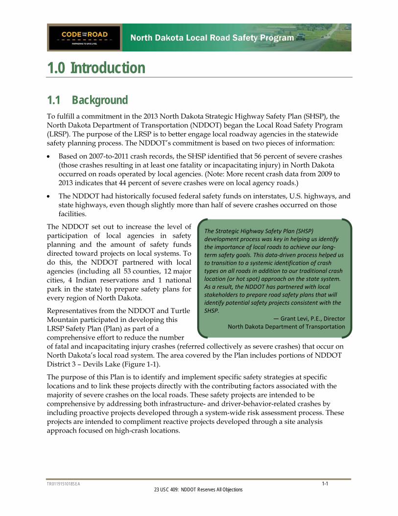
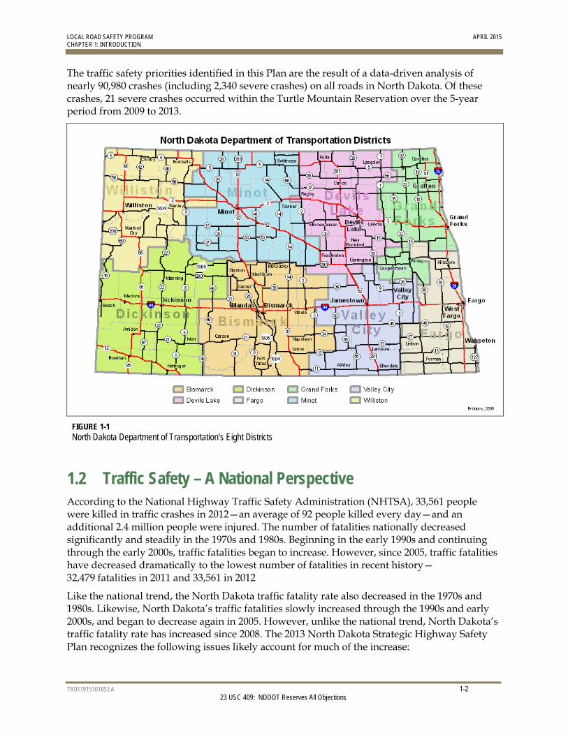
Representatives from the NDDOT and Turtle Mountain participated in developing this LRSP Safety Plan (Plan) as part of a comprehensive effort to reduce the number of fatal and incapacitating injury crashes (referred collectively as severe crashes) that occur on North Dakota’s local road system. The area covered by the Plan includes portions of NDDOT District 3 – Devils Lake (Figure 1-1).
The purpose of this Plan is to identify and implement specific safety strategies at specific locations and to link these projects directly with the contributing factors associated with the majority of severe crashes on the local roads. These safety projects are intended to be comprehensive by addressing both infrastructure- and driver-behavior-related crashes by including proactive projects developed through a system-wide risk assessment process. These projects are intended to compliment reactive projects developed through a site analysis approach focused on high-crash locations.
The Strategic Highway Safety Plan (SHSP) development process was key in helping us identify the importance of local roads to achieve our long‐term safety goals. This data‐driven process helped us to transition to a systemic identification of crash types on all roads in addition to our traditional crash location (or hot spot) approach on the state system. As a result, the NDDOT has partnered with local stakeholders to prepare road safety plans that will identify potential safety projects consistent with the SHSP.
— Grant Levi, P.E., Director North Dakota Department of Transportation
LOCAL ROAD SAFETY PROGRAM APRIL 2015 CHAPTER 1: INTRODUCTION
TR0119151018SEA 1-2 23 USC 409: NDDOT Reserves All Objections
The traffic safety priorities identified in this Plan are the result of a data-driven analysis of nearly 90,980 crashes (including 2,340 severe crashes) on all roads in North Dakota. Of these crashes, 21 severe crashes occurred within the Turtle Mountain Reservation over the 5-year period from 2009 to 2013.
FIGURE 1-1 North Dakota Department of Transportation’s Eight Districts
1.2 Traffic Safety – A National Perspective According to the National Highway Traffic Safety Administration (NHTSA), 33,561 people were killed in traffic crashes in 2012—an average of 92 people killed every day—and an additional 2.4 million people were injured. The number of fatalities nationally decreased significantly and steadily in the 1970s and 1980s. Beginning in the early 1990s and continuing through the early 2000s, traffic fatalities began to increase. However, since 2005, traffic fatalities have decreased dramatically to the lowest number of fatalities in recent history—32,479 fatalities in 2011 and 33,561 in 2012
Like the national trend, the North Dakota traffic fatality rate also decreased in the 1970s and 1980s. Likewise, North Dakota’s traffic fatalities slowly increased through the 1990s and early 2000s, and began to decrease again in 2005. However, unlike the national trend, North Dakota’s traffic fatality rate has increased since 2008. The 2013 North Dakota Strategic Highway Safety Plan recognizes the following issues likely account for much of the increase:
LOCAL ROAD SAFETY PROGRAM APRIL 2015 CHAPTER 1: INTRODUCTION
TR0119151018SEA 1-3 23 USC 409: NDDOT Reserves All Objections
Shifts in the age of the driving population.
Steady increase in the number of vehicle miles traveled in North Dakota, which is counter to the flat or decreasing national trend in travel.
Other states have a longer history using a systemic investment approach to focus on locations with risk factors for severe crashes.
The growing challenges of providing emergency medical response and quick access to advanced health care in rural areas.
1.2.1 AASHTO’s Strategic Highway Safety Plan and Safety Emphasis Areas In the late 1990s, the American Association of State Highway and Transportation Officials (AASHTO) and the Federal Highway Administration (FHWA) supported a comprehensive and data-driven approach to reduce the number of traffic-related fatalities. Both AASHTO and the FHWA concluded that up to that point, states’ efforts had not been effective in lowering the number of severe crashes because: (1) efforts were not focused on severe crashes nor the primary factors resulting in severe crashes; and (2) safety project selection was not part of a data-driven process that implemented effective strategies at locations most at risk for a severe crash.
AASHTO and the FHWA recommended a safety program development process that included 22 categories (or safety emphasis areas) in the areas of drivers, special users, vehicles, highways, emergency services, and management. The objective of this first step is to help agencies consider the 4Es of safety—education, enforcement, engineering, and emergency medical services (EMS)—when identifying safety priorities for their roads. In addition, selecting safety emphasis areas focuses agency efforts on safety strategies linked to the issue.
In 2007, AASHTO set a goal to reduce the number of traffic fatalities nationally by 1,000 each year for the next 20 years, which is an integral first step in a national Toward Zero Deaths safety vision. FHWA has determined that this goal will be reached only by partnering with individual states. This partnering will lead to more successful project implementation and will result in programs that target the factors contributing to the greatest number of fatal and severe injury crashes.
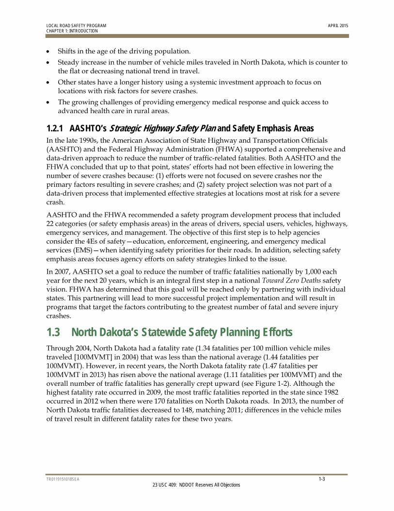
1.3 North Dakota’s Statewide Safety Planning Efforts Through 2004, North Dakota had a fatality rate (1.34 fatalities per 100 million vehicle miles traveled [100MVMT] in 2004) that was less than the national average (1.44 fatalities per 100MVMT). However, in recent years, the North Dakota fatality rate (1.47 fatalities per 100MVMT in 2013) has risen above the national average (1.11 fatalities per 100MVMT) and the overall number of traffic fatalities has generally crept upward (see Figure 1-2). Although the highest fatality rate occurred in 2009, the most traffic fatalities reported in the state since 1982 occurred in 2012 when there were 170 fatalities on North Dakota roads. In 2013, the number of North Dakota traffic fatalities decreased to 148, matching 2011; differences in the vehicle miles of travel result in different fatality rates for these two years.
LOCAL ROAD SAFETY PROGRAM APRIL 2015 CHAPTER 1: INTRODUCTION
TR0119151018SEA 1-4 23 USC 409: NDDOT Reserves All Objections
FIGURE 1-2 Fatality Rate – National and North Dakota (2004 to 2013)
In 2013, the NDDOT updated the state’s SHSP. Based on severe crashes (Table 1-1), the 2013 SHSP identified the following safety emphasis areas, as well as priority safety strategies in each area:
Young drivers (under age 21)
Speeding or aggressive driving
Alcohol-related
Unbelted vehicle occupants
Lane departure
Intersections
North Dakota also adopted a long-term vision of zero fatalities on its roadways. Achieving this vision will require many years and dramatic shifts in the safety culture for North Dakota. An aggressive intermediate goal was set to reduce the 3-year traffic fatality average to 100 or fewer by 2020.
LOCAL ROAD SAFETY PROGRAM APRIL 2015 CHAPTER 1: INTRODUCTION
TR0119151018SEA 1-5 23 USC 409: NDDOT Reserves All Objections
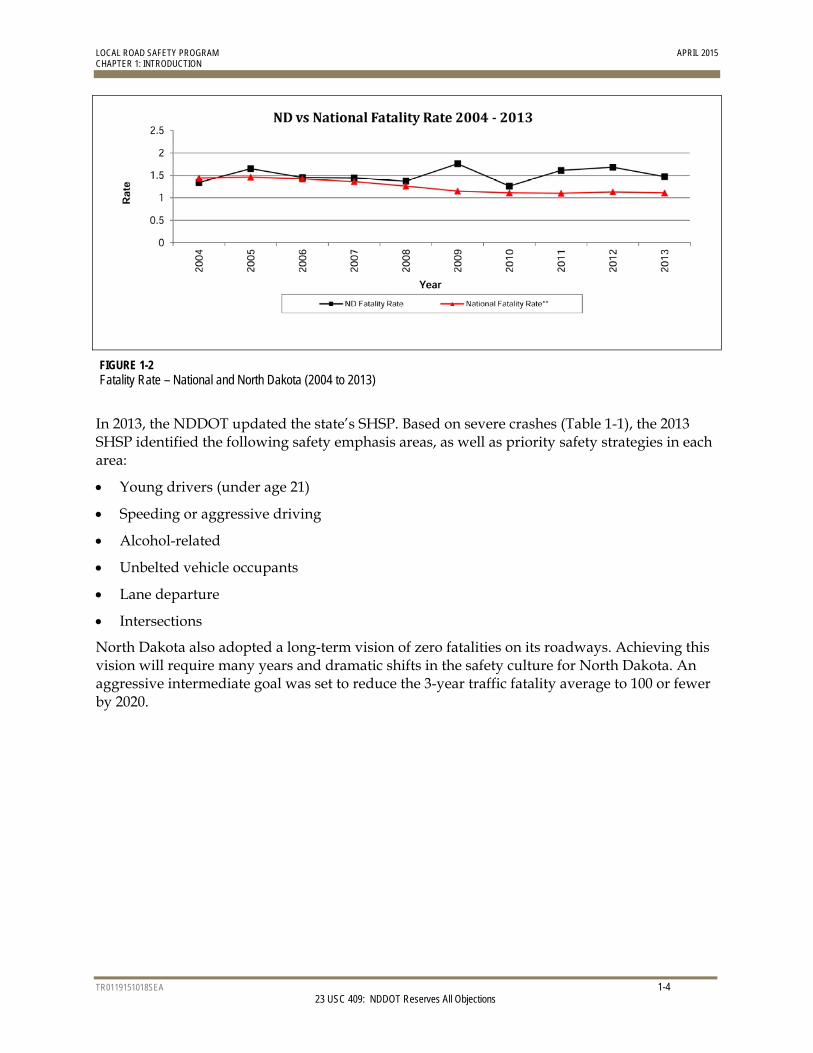
TABLE 1-1 North Dakota Fatal and Severe Injury Crashes by AASHTO Safety Emphasis Area
Safety Emphasis Area
Statewide Crashes (All Roads)
Percent Number
Drivers
Involving Driver under Age 21 21% 492
Involving drivers over the age of 64 12% 279
Speeding or Aggressive Driving 25% 576
Alcohol-Related 28% 663
Distracted, asleep, or fatigued drivers 9% 208
Unbelted Vehicle Occupants 30% 699
Special Users Pedestrians crashes 5% 109
Bicycle crashes 1% 34
Vehicles Motorcycles crashes 11% 248
Highways
Train-vehicle collisions 1% 18
Lane-Departure Including both lane-departure (1,094 severe crashes) and head-on/ sideswipe-opposing crashes (204 severe crashes)
46% 1,067
Intersections 23% 540
Work zone crashes 2% 42
Total Severe (Fatal and Incapacitating Injury) Crashes 2,340
Notes: Information is from the 2009-to-2013 North Dakota crash data records, which is an update to the information in the 2013 North Dakota SHSP that used 2007-to-2011 crash records. Numbers in this table do not add up to the statewide crash numbers because one crash may be categorized into multiple emphasis areas. For example, one crash may involve a young driver at an intersection and, therefore, be included in both of these emphasis areas.
1.4 Local Road Safety Program Overview North Dakota’s local road system encompasses more than 97,500 miles of roadway out of approximately 106,000 miles statewide. Although, historically, more than 50 percent of severe crashes in North Dakota occurred on local roads, the density of these crashes was very low (approximately 0.002 severe crash per mile per year). As a result, local agencies were unable to identify high-crash locations to nominate for funding through the Highway Safety Improvement Program (HSIP). Therefore, using stand-in data for the severe crashes, safety projects were identified using a systemic process to evaluate at-risk locations. The use of the systemic process was necessary due to the low crash density. Based on revised FHWA policy, the NDDOT expanded the HSIP to include projects identified through the systemic analysis of local roads.
The focus areas of the systemic risk assessment are rural, paved local highways1, and urban arterials and collectors in North Dakota’s larger cities (cities with a population greater
1 Does not include all paved roads outside municipal limits, but focuses on routes that serve regional travel. For example, a loop road that is paved and yet only provides access to a residential neighborhood was considered to be a local road given the type of traffic served by the facility.
LOCAL ROAD SAFETY PROGRAM APRIL 2015 CHAPTER 1: INTRODUCTION
TR0119151018SEA 1-6 23 USC 409: NDDOT Reserves All Objections
than 5,000). Paved, rural local highways were selected based on an analysis of statewide crash data that indicated that approximately 59 percent of severe local road crashes occurred on rural county roads. Of these crashes, approximately 40 percent occurred on paved roads, which account for less than 10 percent of county roads (approximately 6,200 miles). Further analysis indicated that on these rural highways, the most at-risk elements were roadway segments (76 percent of severe crashes), horizontal curves (31 percent of severe crashes), and intersections (20 percent of severe crashes).
Major cities were selected as a focus because approximately 90 percent of the severe local roadway crashes occurred within the city boundaries of the 12 cities in this category. Furthermore, 56 percent of the severe crashes occurred on urban arterials and collectors. In addition, because these 12 cities are responsible for operation and maintenance of U.S. highway and state highway routes within the municipal limits (not including fully access-managed facilities, such as freeways), the U.S. and state highways were included in the review.
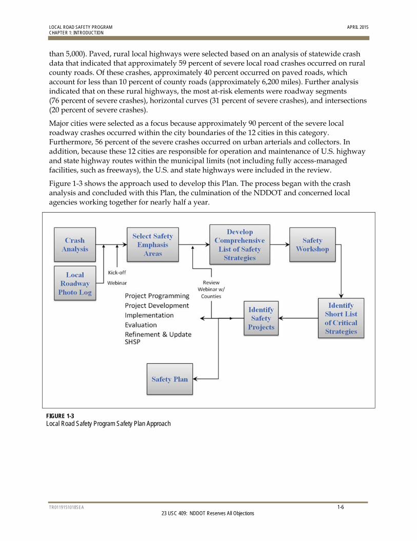
Figure 1-3 shows the approach used to develop this Plan. The process began with the crash analysis and concluded with this Plan, the culmination of the NDDOT and concerned local agencies working together for nearly half a year.
FIGURE 1-3 Local Road Safety Program Safety Plan Approach
TR0119151018SEA 2-1 23 USC 409: NDDOT Reserves All Objections
2.0 Turtle Mountain Safety Emphasis Areas and Crash Overview
The first step in the process to prepare the Plan was to conduct a crash analysis overview statewide for North Dakota.
2.1 Turtle Mountain Crash Overview
2.1.1 North Dakota Crash Mapping Crash data was taken from NDDOT Crash Reporting System (CRS) and placed into ArcGIS for data exportation based on specific locations relative to local roads. The most recent five-year period of crash data (from 2009 to 2013) was analyzed and used to determine risk factors specific to the local roads. Consistent with the NDDOT’s SHSP, the analysis focused on severe (fatal and incapacitating injury) crashes.
2.1.2 Facilities Analyzed The crash analysis was broken into three main facility types: roadway segments, curves, and intersections:
Rural local paved and major gravel roadway segments were analyzed. Other local gravel roads were removed from the analysis because of the relatively low percentage of severe crashes and the lack of infrastructure-based strategies that can be applied to this roadway type.
Local rural road intersections with state highways or other local roads were included in the analysis. Local non-CMC gravel roads intersecting with other local roads were removed from the analysis due to the very low number of crashes at these intersections.
Horizontal curves on paved rural local roads were included in the analysis.
All other local roadway segments and intersections, including gravel roads, were reviewed for locations with multiple severe crashes or “hot spots.”
2.1.3 Crash Data Sets Crash data for the five years from 2009 to 2013 was used for the crash analysis. In safety analysis, it is recommended that more than one year of data be studied to reduce the possibility of examining an unusual year. It is also important to include as many years as necessary to produce a data set that will provide statistically reliable results but not include too many years so that changed conditions are a concern (for example, reconstructed roads, addition of STOP signs, and changed speed limits). For Turtle Mountain, there were not enough crashes to be statistically reliable; therefore, the analysis also considered crashes from all Phases of the LRSP, statewide data, or national research.
LOCAL ROAD SAFETY PROGRAM APRIL 2015 CHAPTER 2: TURTLE MOUNTAIN SAFETY EMPHASIS AREAS AND CRASH OVERVIEW
TR0119151018SEA 2-2 23 USC 409: NDDOT Reserves All Objections
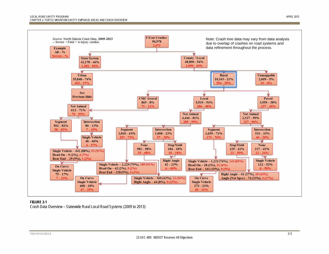
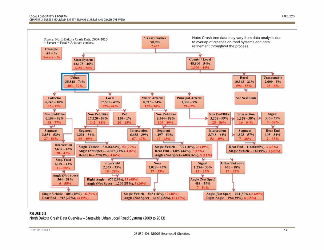
The Turtle Mountain data set includes 58 crashes on local roads; of these, 13 were fatal or incapacitating injury crashes. Disaggregating statewide severe crashes by road type (paved, gravel, or local), area (urban versus rural), and crash type category (intersection versus roadway segment crashes) resulted in the distributions shown in Figure 2-1 and Figure 2-2. This review shows that, on the local system, severe lane departure crashes on paved roads and angle crashes at Thru-STOP intersections were overrepresented. Based on statewide traffic safety data, severe lane departure crashes along curves are also overrepresented.
LOCAL ROAD SAFETY PROGRAM APRIL 2015 CHAPTER 2: TURTLE MOUNTAIN SAFETY EMPHASIS AREAS AND CRASH OVERVIEW
TR0119151018SEA 2-3 23 USC 409: NDDOT Reserves All Objections
FIGURE 2-1 Crash Data Overview – Statewide Rural Local Road Systems (2009 to 2013)
Note: Crash tree data may vary from data analysis due to overlap of crashes on road systems and data refinement throughout the process.
LOCAL ROAD SAFETY PROGRAM APRIL 2015 CHAPTER 2: TURTLE MOUNTAIN SAFETY EMPHASIS AREAS AND CRASH OVERVIEW
TR0119151018SEA 2-4 23 USC 409: NDDOT Reserves All Objections
FIGURE 2-2 North Dakota Crash Data Overview – Statewide Urban Local Road Systems (2009 to 2013)
Note: Crash tree data may vary from data analysis due to overlap of crashes on road systems and data refinement throughout the process.
LOCAL ROAD SAFETY PROGRAM APRIL 2015 CHAPTER 2: TURTLE MOUNTAIN SAFETY EMPHASIS AREAS AND CRASH OVERVIEW
TR0119151018SEA 2-5 23 USC 409: NDDOT Reserves All Objections
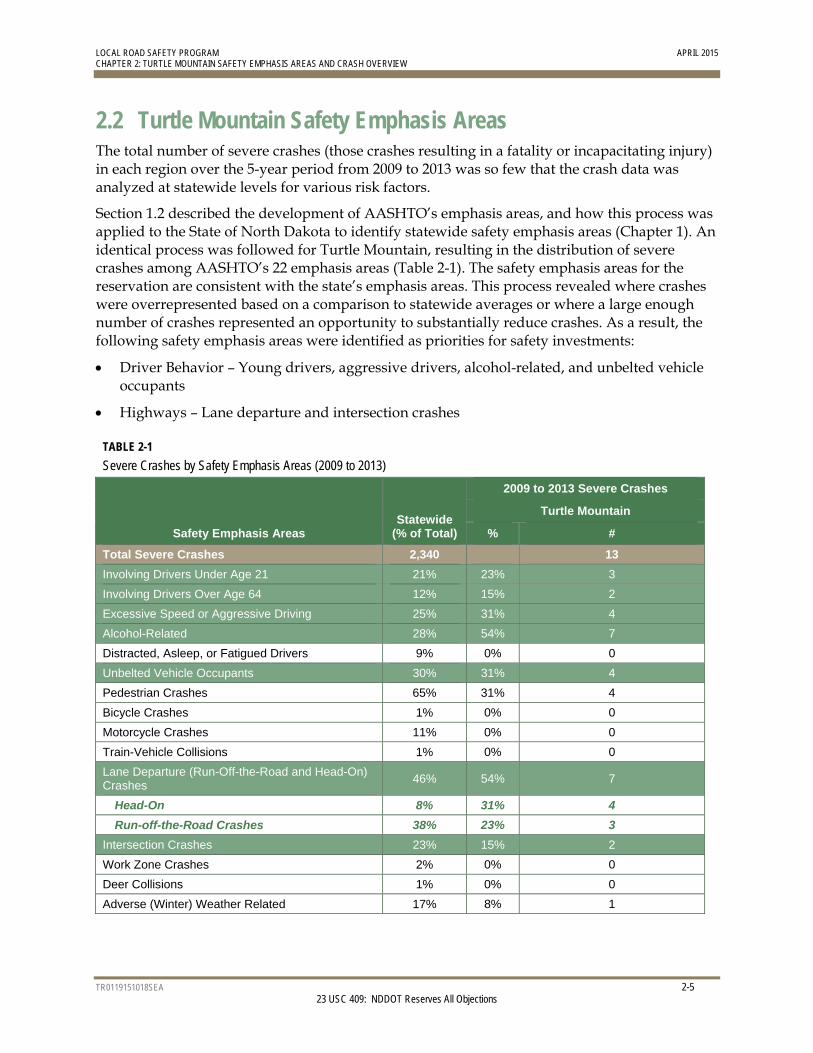
2.2 Turtle Mountain Safety Emphasis Areas The total number of severe crashes (those crashes resulting in a fatality or incapacitating injury) in each region over the 5-year period from 2009 to 2013 was so few that the crash data was analyzed at statewide levels for various risk factors.
Section 1.2 described the development of AASHTO’s emphasis areas, and how this process was applied to the State of North Dakota to identify statewide safety emphasis areas (Chapter 1). An identical process was followed for Turtle Mountain, resulting in the distribution of severe crashes among AASHTO’s 22 emphasis areas (Table 2-1). The safety emphasis areas for the reservation are consistent with the state’s emphasis areas. This process revealed where crashes were overrepresented based on a comparison to statewide averages or where a large enough number of crashes represented an opportunity to substantially reduce crashes. As a result, the following safety emphasis areas were identified as priorities for safety investments:
Driver Behavior – Young drivers, aggressive drivers, alcohol-related, and unbelted vehicle occupants
Highways – Lane departure and intersection crashes
TABLE 2-1
Severe Crashes by Safety Emphasis Areas (2009 to 2013)
Safety Emphasis Areas Statewide
(% of Total)
2009 to 2013 Severe Crashes
Turtle Mountain
% #
Total Severe Crashes 2,340 13
Involving Drivers Under Age 21 21% 23% 3
Involving Drivers Over Age 64 12% 15% 2
Excessive Speed or Aggressive Driving 25% 31% 4
Alcohol-Related 28% 54% 7
Distracted, Asleep, or Fatigued Drivers 9% 0% 0
Unbelted Vehicle Occupants 30% 31% 4
Pedestrian Crashes 65% 31% 4
Bicycle Crashes 1% 0% 0
Motorcycle Crashes 11% 0% 0
Train-Vehicle Collisions 1% 0% 0
Lane Departure (Run-Off-the-Road and Head-On) Crashes
46% 54% 7
Head-On 8% 31% 4
Run-off-the-Road Crashes 38% 23% 3
Intersection Crashes 23% 15% 2
Work Zone Crashes 2% 0% 0
Deer Collisions 1% 0% 0
Adverse (Winter) Weather Related 17% 8% 1
LOCAL ROAD SAFETY PROGRAM APRIL 2015 CHAPTER 2: TURTLE MOUNTAIN SAFETY EMPHASIS AREAS AND CRASH OVERVIEW
TR0119151018SEA 2-6 23 USC 409: NDDOT Reserves All Objections
Strategies to reduce crashes depend on whether a safety emphasis area is infrastructure-based or driver behavior-based. Infrastructure-based emphasis areas refer to characteristics of the location (for example, a roadway segment, curve, or intersection) where crashes occurred. Driver behavior-based emphasis areas refer to motorist characteristics or actions that contribute to crashes. Because driver behavior is tied to laws made at the national and state levels, roadway agencies generally have less ability to address driver-behavior-based emphasis areas. The most effective approach for road authorities to address driver behavior-based emphasis areas is to focus on public education and law enforcement through cooperation and collaboration with other tribe staff. Generally, more opportunities exist for agency road authorities to address infrastructure-based emphasis areas, because many of the associated strategies can be implemented as separate roadway improvement projects, or along with other planned improvements. Specific infrastructure- and driver behavior-based strategies presented to the participants of the safety workshop held for the reservation are provided in Section 3.2.
2.3 Crash Risk Factors The objective of the analytical process is to identify candidates for safety investment based on two criteria: high-crash locations and at-risk locations. A more detailed crash analysis was performed for each priority crash type to identify (1) locations where these priority crash types occur at a rate of one or more severe crashes per year, and (2) basic roadway and traffic characteristics of locations with severe crashes. These characteristics are not considered to be the cause of crashes, but instead are used to determine the risk that a future severe crash may occur at a particular location. Information from historic crashes was used to evaluate the remainder of the reservation’s local road system and prioritize locations for safety investment based on similar characteristics.
2.3.1 Rural Roadway Segments – Crashes on Paved Roads Of the more than 97,500 miles of local road system in North Dakota, only 7 percent of the roads are paved. However, 40 percent of crashes occured on paved roads. Therefore, the focus of the LRSP is on rural paved roadway segments.
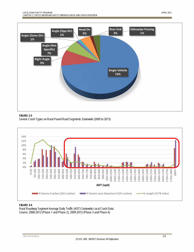
There are 71 miles of studied rural paved roads in the reservation. From 2009 to 2013, 13 severe crashes were reported on these reservation roads. The predominant crash type on these types of roads statewide was single vehicle lane departure (Figure 2-3). The following five risk factors were identified for rural lane departure crashes on paved roads statewide:
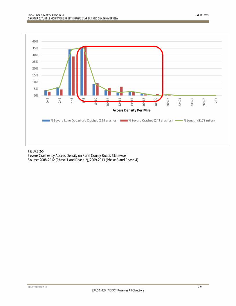
1. Average Daily Traffic (ADT) – Of the rural paved roads, 28 percent of the segment miles have an ADT greater than 450 vehicles per day. However, 60 percent of the severe lane departure crashes occurred at or above this ADT (Figure 2-4). Therefore, any segment with an ADT greater than 450 vehicles per day received a star.
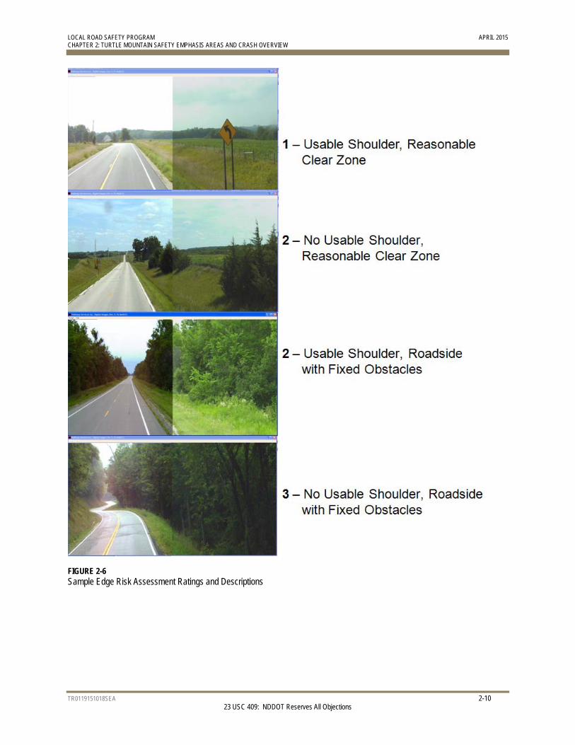
2. Access Density – Nationally, research has shown that an access density of eight or more access points per mile (including field entrances, commercial entrances, roadway access, etc.) increase the likelihood of a severe crash occurring. North Dakota’s review of severe crashes on their rural county roads (shown in Figure 2-5) demonstrates a similar relationship. Therefore, any roadway segment with an access density greater than or equal to eight access points per mile received a star.
LOCAL ROAD SAFETY PROGRAM APRIL 2015 CHAPTER 2: TURTLE MOUNTAIN SAFETY EMPHASIS AREAS AND CRASH OVERVIEW
TR0119151018SEA 2-7 23 USC 409: NDDOT Reserves All Objections
3. Lane Departure Crash Density – The average lane departure crash density for Turtle Mountain was 0.064 crash per mile. Due to this limited number of crashes, any roadway segment where the lane departure crash density was greater than the average for the central region received a star.
4. Critical Radius Curve Density – Nationally, lane departure crashes frequently occur within curves. Curves with radii between 500 and 1,200 feet (that is, critical radius curves) have a higher severe crash rate than other curves and roadway segments with more curves in this range are considered to have greater risk. The risk factor is determined by the number of critical radius curves divided by the length of the segment. The average critical curve radius density for these types of curves along roadway segments was 0.218 curve per mile for the central region. Any segment with a critical radius curve density greater than or equal to the region average received a star.
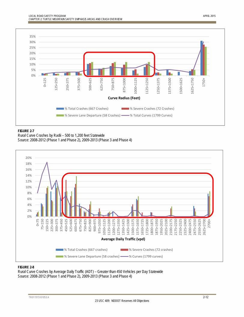
5. Edge Risk Assessment (ERA) – A rating system was developed to categorize the risk level of vehicles leaving the travel lane. Roads with a usable shoulder and reasonable clear zone received a rating of 1. Roads with little or no usable shoulder but with a reasonable clear zone received a rating of 2, as did roads with a usable shoulder but with fixed objects in the clear zone. Roads with no usable shoulder and fixed objects in the clear zone received a rating of 3. Examples of these edge risks are shown in Figure 2-6. Roads with a rating of 2 or 3 received a star.
Detailed segment analyses and results for the reservation are provided in Chapter 4. A prioritization process for each roadway segment was put into place using the five risk factors by giving stars to each risk factor present. The highest priority roadway segments received the most stars. In cases where roadway segments received the same number of stars, the ERA, and ADT were used to break the tie.
LOCAL ROAD SAFETY PROGRAM APRIL 2015 CHAPTER 2: TURTLE MOUNTAIN SAFETY EMPHASIS AREAS AND CRASH OVERVIEW
TR0119151018SEA 2-8 23 USC 409: NDDOT Reserves All Objections
FIGURE 2-3 Severe Crash Types on Rural Paved Road Segments Statewide (2009 to 2013)
FIGURE 2-4 Rural Roadway Segment Average Daily Traffic (ADT) Statewide Local Crash Data Source: 2008-2012 (Phase 1 and Phase 2), 2009-2013 (Phase 3 and Phase 4)
Single Vehicle73%
Right Angle9%
Angle (Not Specific)
7%
Angle (Same Dir)1%
Angle (Opp Dir)1%
Head On5%
Sideswipe Passing1%
Rear End3%
0%
2%
4%
6%
8%
10%
12%
14%
0<50
50<100
100<150
150<200
200<250
250<300
300<350
350<400
400<450
450<500
500<550
550<600
600<650
650<700
700<750
750<800
800<850
850<900
900<950
950<1000
1000<1050
1050<1100
1100<1150
1150<1200
1200<1250
1250<1300
1300<1350
1350<1400
1400<1450
1450<1500
1500<1550
1550<1600
1600<1650
1650<1700
1700<1750
1750<1800
1800+
ADT (vpd)
% Severe Crashes (242 crashes) % Severe Lane Departure (129 crashes) % Length (5178 miles)
LOCAL ROAD SAFETY PROGRAM APRIL 2015 CHAPTER 2: TURTLE MOUNTAIN SAFETY EMPHASIS AREAS AND CRASH OVERVIEW
TR0119151018SEA 2-9 23 USC 409: NDDOT Reserves All Objections
FIGURE 2-5 Severe Crashes by Access Density on Rural County Roads Statewide Source: 2008-2012 (Phase 1 and Phase 2), 2009-2013 (Phase 3 and Phase 4)
0%
5%
10%
15%
20%
25%
30%
35%
40%
0<2
2<4
4<6
6<8
8<10
10<12
12<14
14<16
16<18
18<20
20<22
22<24
24<26
26<28
28+
Access Density Per Mile
% Severe Lane Departure Crashes (129 crashes) % Severe Crashes (242 crashes) % Length (5178 miles)
LOCAL ROAD SAFETY PROGRAM APRIL 2015 CHAPTER 2: TURTLE MOUNTAIN SAFETY EMPHASIS AREAS AND CRASH OVERVIEW
TR0119151018SEA 2-10 23 USC 409: NDDOT Reserves All Objections
FIGURE 2-6 Sample Edge Risk Assessment Ratings and Descriptions

LOCAL ROAD SAFETY PROGRAM APRIL 2015 CHAPTER 2: TURTLE MOUNTAIN SAFETY EMPHASIS AREAS AND CRASH OVERVIEW
TR0119151018SEA 2-11 23 USC 409: NDDOT Reserves All Objections
2.3.2 Rural Curves – Crashes on Paved Roads in Curves Detailed crash analysis included horizontal curves on rural paved local roads. Research indicates horizontal curves with certain characteristics contribute to the overall frequency of lane departure crashes. The 71 miles of rural paved roads in the reservation contain 19 curves totaling approximately 3 miles in length (4 percent of the road system mileage).
With only 2 severe crashes along curves reported from 2009 to 2013, too few crashes occurred on these curves in Turtle Mountain to serve as a reliable indicator of the relative degree of risk. However, data statewide shows the importance of safety improvements on curves to reduce severe crashes since many severe lane departure crashes occur in curves. As a result, the LRSP team used characteristics of curves in the reservation where crashes had occurred, as well as available information from similar analysis of national and statewide data. Results from Cost-Benefit Analysis of In-Vehicle Technologies and Infrastructure Changes to Avoid Crashes Along Curves and Shoulders (compiled by the University of Minnesota and CH2M HILL in June 2009) were also used in curve analysis and prioritization.
Based on a review of these sources, the following five risk factors were identified for crashes along curves:
1. Curve Radius – The reservation did not have enough severe curve crashes to provide insight into North Dakota’s characteristics (Figure 2-7). National data shows that curves with mid-range radii had higher crash densities. An upper limit of 1,200 feet was used for at-risk curves, because 1,200 feet is a 60-mile-per-hour design speed based on AASHTO’s A Policy on Geometric Design of Highways and Streets (commonly referred to as the “Green Book;” 6th edition, 2011). A lower limit of 500 feet was used to represent the severe lane departure crashes that were reported in the region from 2009 to 2013. Any curve with a radius between 500 and 1,200 feet received a star.
2. Average Daily Traffic (ADT) – Traffic volumes over 450 vehicles per day represent a higher risk for crashes (Figure 2-8). Sixty-seven percent of severe lane departure crashes occurred along curves with this ADT and above, while only thirty-two percent of curves are represented in this range. Therefore, curves with an ADT over 450 vehicles per day received a star.
3. Intersection within the Curve – In the reservation, the presence of an intersection within a curve increased the risk for a severe crash. Curves with at least one intersection within the curve received a star.
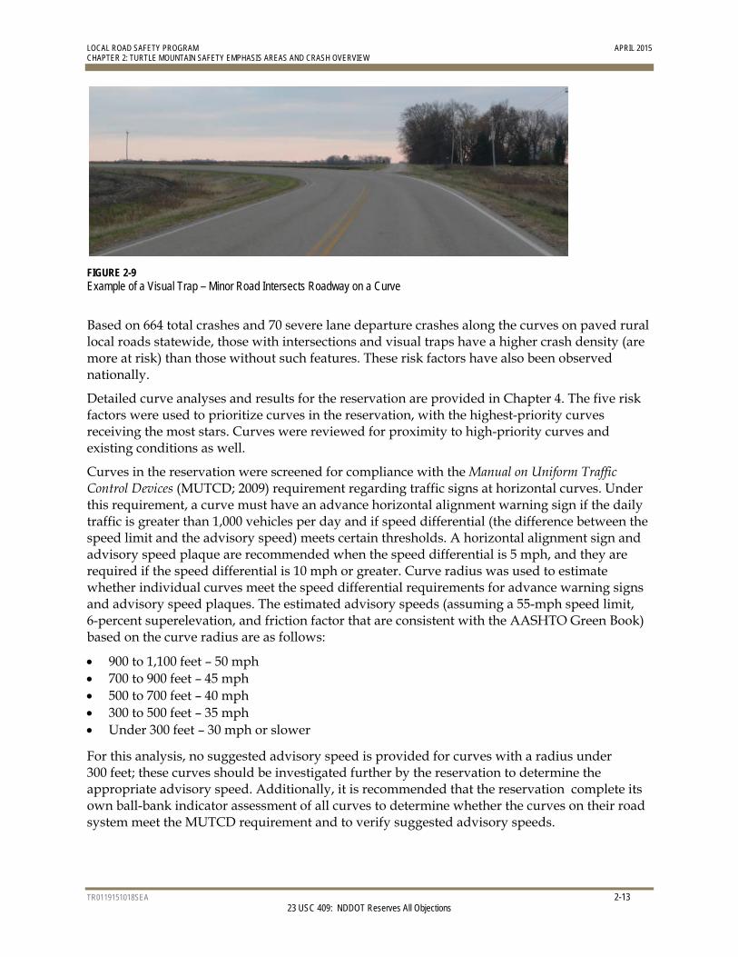
4. Visual Trap – A visual trap exists when the crest of a vertical curve is located before a horizontal curve or where a minor road, tree line, or line of utility poles continues on a tangent to the curve, thereby creating the illusion that the road continues straight ahead (Figure 2-9). The presence of a visual trap increased the risk of crashes in the reservation and, therefore, received a star.
5. Severe Crashes – If a severe crash occurred on a curve between 2009 and 2013, the curve received a star.
LOCAL ROAD SAFETY PROGRAM APRIL 2015 CHAPTER 2: TURTLE MOUNTAIN SAFETY EMPHASIS AREAS AND CRASH OVERVIEW
TR0119151018SEA 2-12 23 USC 409: NDDOT Reserves All Objections
FIGURE 2-7 Rural Curve Crashes by Radii – 500 to 1,200 feet Statewide Source: 2008-2012 (Phase 1 and Phase 2), 2009-2013 (Phase 3 and Phase 4)
FIGURE 2-8 Rural Curve Crashes by Average Daily Traffic (ADT) – Greater than 450 Vehicles per Day Statewide Source: 2008-2012 (Phase 1 and Phase 2), 2009-2013 (Phase 3 and Phase 4)
0%
5%
10%
15%
20%
25%
30%
35%
0<125
125<250
250<375
375<500
500<625
625<750
750<875
875<1000
1000<1125
1125<1250
1250<1375
1375<1500
1500<1625
1625<1750
1750+
Curve Radius (Feet)
% Total Crashes (667 Crashes) % Severe Crashes (72 Crashes)
% Severe Lane Departure (58 Crashes) % Total Curves (1799 Curves)
0%
2%
4%
6%
8%
10%
12%
14%
16%
18%
20%
0<75
75<150
150<225
225<300
300<375
375<450
450<525
525<600
600<675
675<750
750<825
825<900
900<975
975<1050
1050<1125
1125<1200
1200<1275
1275<1350
1350<1425
1425<1500
1500<1575
1575<1650
1650<1725
1725<1800
1800<1875
1875<1950
1950<2025
2025<2100
2100<2175
2175<2250
2250<2325
2325<2400
2400<2475
2475<2550
2550<2625
2625<2700
2700+
Average Daily Traffic (vpd)
% Total Crashes (667 crashes) % Severe Crashes (72 crashes)
% Severe Lane Departure (58 crashes) % Curves (1799 curves)
LOCAL ROAD SAFETY PROGRAM APRIL 2015 CHAPTER 2: TURTLE MOUNTAIN SAFETY EMPHASIS AREAS AND CRASH OVERVIEW
TR0119151018SEA 2-13 23 USC 409: NDDOT Reserves All Objections
FIGURE 2-9 Example of a Visual Trap – Minor Road Intersects Roadway on a Curve
Based on 664 total crashes and 70 severe lane departure crashes along the curves on paved rural local roads statewide, those with intersections and visual traps have a higher crash density (are more at risk) than those without such features. These risk factors have also been observed nationally.
Detailed curve analyses and results for the reservation are provided in Chapter 4. The five risk factors were used to prioritize curves in the reservation, with the highest-priority curves receiving the most stars. Curves were reviewed for proximity to high-priority curves and existing conditions as well.
Curves in the reservation were screened for compliance with the Manual on Uniform Traffic Control Devices (MUTCD; 2009) requirement regarding traffic signs at horizontal curves. Under this requirement, a curve must have an advance horizontal alignment warning sign if the daily traffic is greater than 1,000 vehicles per day and if speed differential (the difference between the speed limit and the advisory speed) meets certain thresholds. A horizontal alignment sign and advisory speed plaque are recommended when the speed differential is 5 mph, and they are required if the speed differential is 10 mph or greater. Curve radius was used to estimate whether individual curves meet the speed differential requirements for advance warning signs and advisory speed plaques. The estimated advisory speeds (assuming a 55-mph speed limit, 6-percent superelevation, and friction factor that are consistent with the AASHTO Green Book) based on the curve radius are as follows:
900 to 1,100 feet – 50 mph 700 to 900 feet – 45 mph 500 to 700 feet – 40 mph 300 to 500 feet – 35 mph Under 300 feet – 30 mph or slower
For this analysis, no suggested advisory speed is provided for curves with a radius under 300 feet; these curves should be investigated further by the reservation to determine the appropriate advisory speed. Additionally, it is recommended that the reservation complete its own ball-bank indicator assessment of all curves to determine whether the curves on their road system meet the MUTCD requirement and to verify suggested advisory speeds.
LOCAL ROAD SAFETY PROGRAM APRIL 2015 CHAPTER 2: TURTLE MOUNTAIN SAFETY EMPHASIS AREAS AND CRASH OVERVIEW
TR0119151018SEA 2-14 23 USC 409: NDDOT Reserves All Objections
If a curve was not selected as a project candidate through the LRSP risk assessment process (although the curve has an ADT greater than 1,000 vehicles per day and a radius under 1,100 feet), the curve was flagged for the reservation to determine the need for additional signs based on MUTCD guidance.
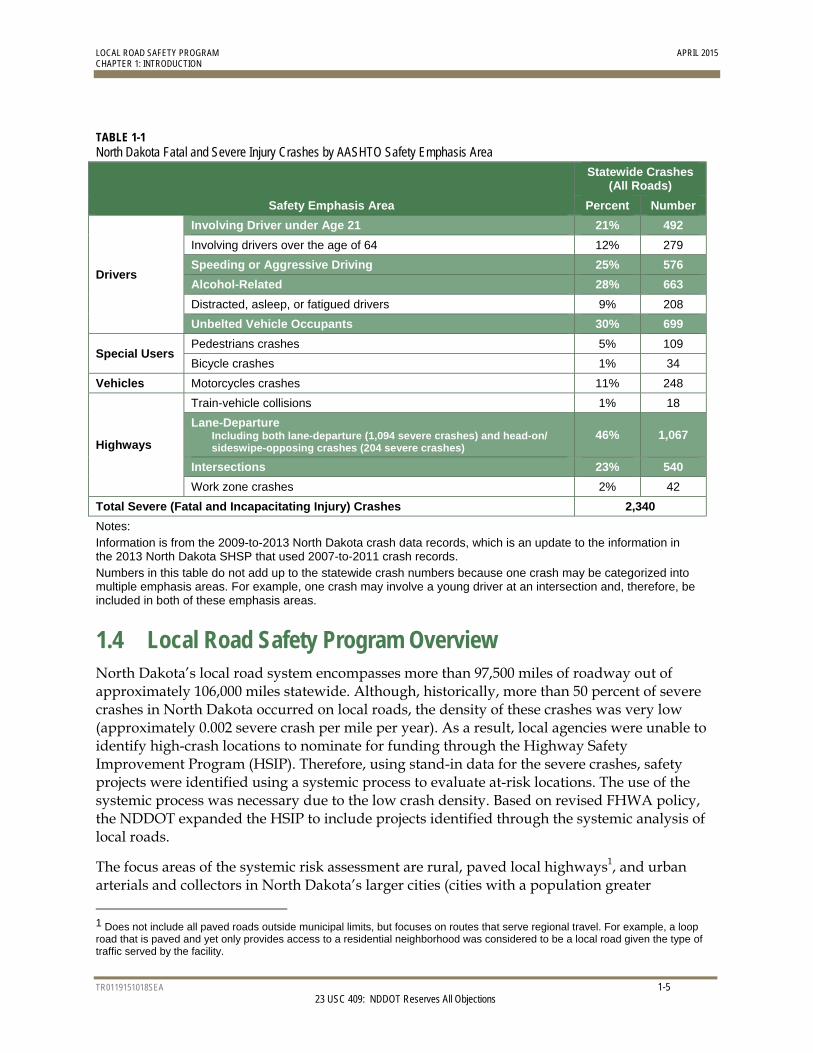
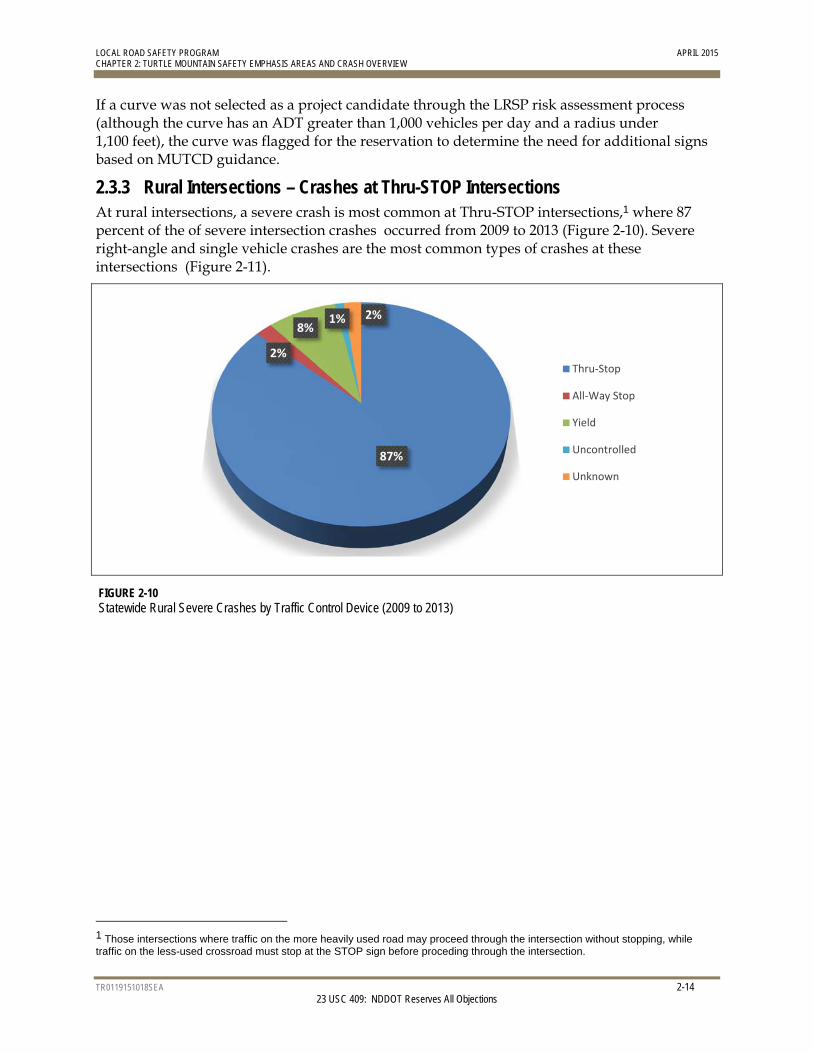
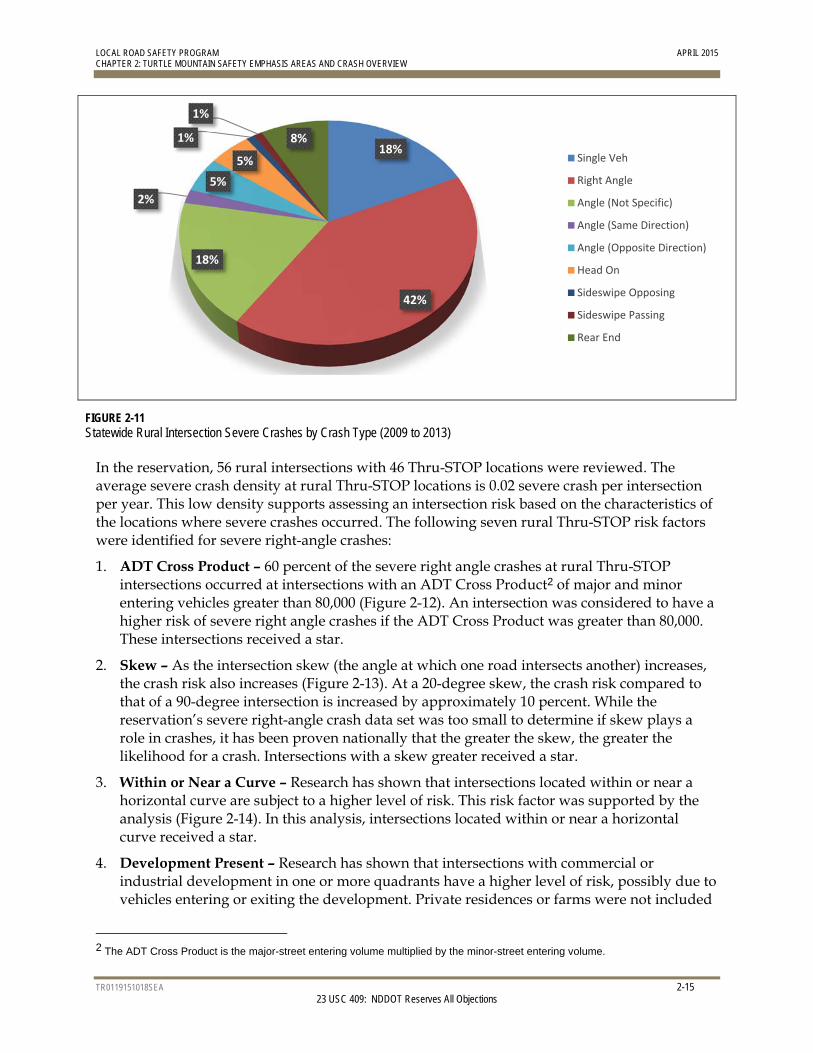
2.3.3 Rural Intersections – Crashes at Thru-STOP Intersections At rural intersections, a severe crash is most common at Thru-STOP intersections,1 where 87 percent of the of severe intersection crashes occurred from 2009 to 2013 (Figure 2-10). Severe right-angle and single vehicle crashes are the most common types of crashes at these intersections (Figure 2-11).
FIGURE 2-10 Statewide Rural Severe Crashes by Traffic Control Device (2009 to 2013)
1 Those intersections where traffic on the more heavily used road may proceed through the intersection without stopping, while traffic on the less-used crossroad must stop at the STOP sign before proceding through the intersection.
87%
2%
8%1% 2%
Thru‐Stop
All‐Way Stop
Yield
Uncontrolled
Unknown
LOCAL ROAD SAFETY PROGRAM APRIL 2015 CHAPTER 2: TURTLE MOUNTAIN SAFETY EMPHASIS AREAS AND CRASH OVERVIEW
TR0119151018SEA 2-15 23 USC 409: NDDOT Reserves All Objections
FIGURE 2-11 Statewide Rural Intersection Severe Crashes by Crash Type (2009 to 2013)
In the reservation, 56 rural intersections with 46 Thru-STOP locations were reviewed. The average severe crash density at rural Thru-STOP locations is 0.02 severe crash per intersection per year. This low density supports assessing an intersection risk based on the characteristics of the locations where severe crashes occurred. The following seven rural Thru-STOP risk factors were identified for severe right-angle crashes:
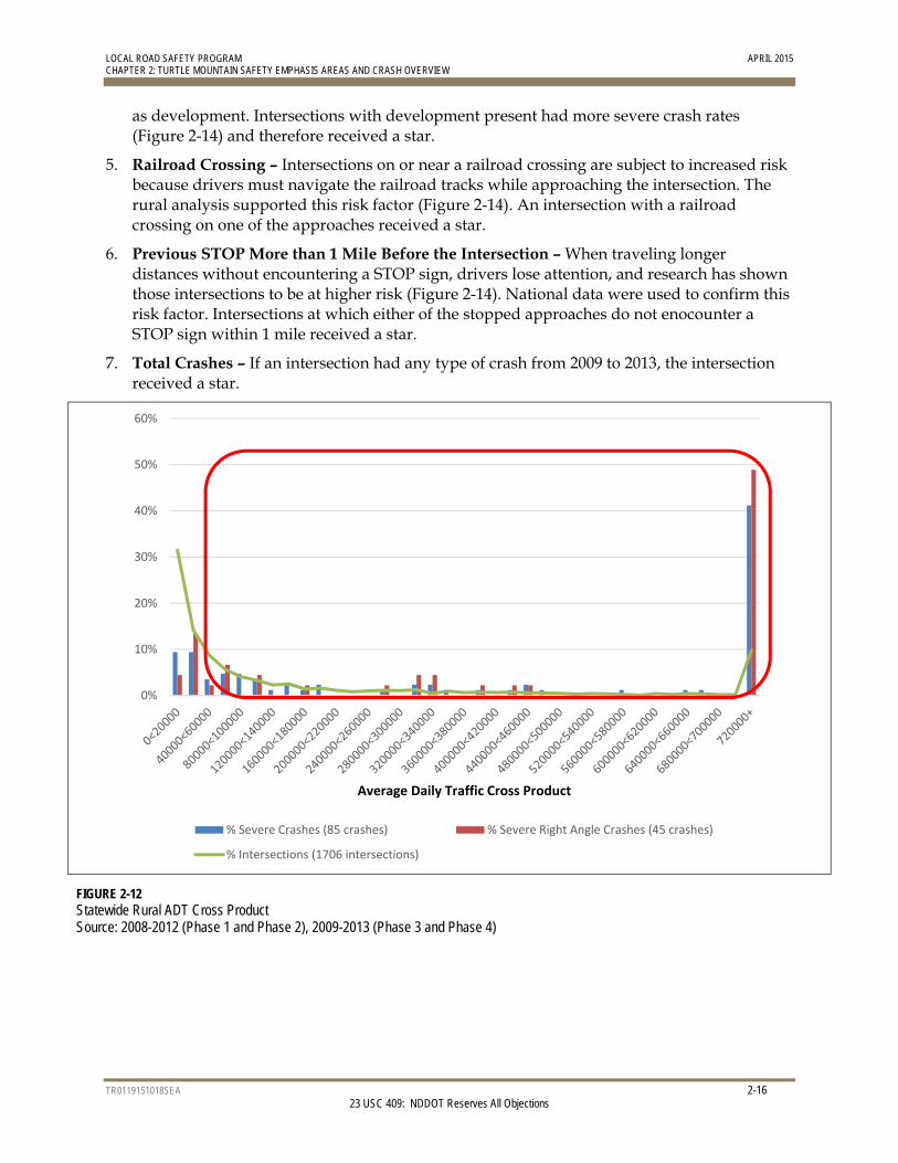
1. ADT Cross Product – 60 percent of the severe right angle crashes at rural Thru-STOP intersections occurred at intersections with an ADT Cross Product2 of major and minor entering vehicles greater than 80,000 (Figure 2-12). An intersection was considered to have a higher risk of severe right angle crashes if the ADT Cross Product was greater than 80,000. These intersections received a star.
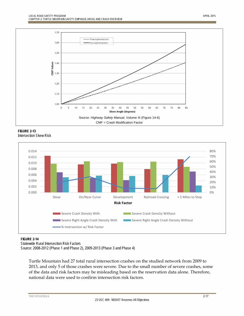
2. Skew – As the intersection skew (the angle at which one road intersects another) increases, the crash risk also increases (Figure 2-13). At a 20-degree skew, the crash risk compared to that of a 90-degree intersection is increased by approximately 10 percent. While the reservation’s severe right-angle crash data set was too small to determine if skew plays a role in crashes, it has been proven nationally that the greater the skew, the greater the likelihood for a crash. Intersections with a skew greater received a star.
3. Within or Near a Curve – Research has shown that intersections located within or near a horizontal curve are subject to a higher level of risk. This risk factor was supported by the analysis (Figure 2-14). In this analysis, intersections located within or near a horizontal curve received a star.
4. Development Present – Research has shown that intersections with commercial or industrial development in one or more quadrants have a higher level of risk, possibly due to vehicles entering or exiting the development. Private residences or farms were not included
2 The ADT Cross Product is the major-street entering volume multiplied by the minor-street entering volume.
18%
42%
18%
2%
5%
5%
1%
1%
8%
Single Veh
Right Angle
Angle (Not Specific)
Angle (Same Direction)
Angle (Opposite Direction)
Head On
Sideswipe Opposing
Sideswipe Passing
Rear End
LOCAL ROAD SAFETY PROGRAM APRIL 2015 CHAPTER 2: TURTLE MOUNTAIN SAFETY EMPHASIS AREAS AND CRASH OVERVIEW
TR0119151018SEA 2-16 23 USC 409: NDDOT Reserves All Objections
as development. Intersections with development present had more severe crash rates (Figure 2-14) and therefore received a star.
5. Railroad Crossing – Intersections on or near a railroad crossing are subject to increased risk because drivers must navigate the railroad tracks while approaching the intersection. The rural analysis supported this risk factor (Figure 2-14). An intersection with a railroad crossing on one of the approaches received a star.
6. Previous STOP More than 1 Mile Before the Intersection – When traveling longer distances without encountering a STOP sign, drivers lose attention, and research has shown those intersections to be at higher risk (Figure 2-14). National data were used to confirm this risk factor. Intersections at which either of the stopped approaches do not enocounter a STOP sign within 1 mile received a star.
7. Total Crashes – If an intersection had any type of crash from 2009 to 2013, the intersection received a star.
FIGURE 2-12 Statewide Rural ADT Cross Product Source: 2008-2012 (Phase 1 and Phase 2), 2009-2013 (Phase 3 and Phase 4)
0%
10%
20%
30%
40%
50%
60%
Average Daily Traffic Cross Product
% Severe Crashes (85 crashes) % Severe Right Angle Crashes (45 crashes)
% Intersections (1706 intersections)
LOCAL ROAD SAFETY PROGRAM APRIL 2015 CHAPTER 2: TURTLE MOUNTAIN SAFETY EMPHASIS AREAS AND CRASH OVERVIEW
TR0119151018SEA 2-17 23 USC 409: NDDOT Reserves All Objections
Source: Highway Safety Manual, Volume III (Figure 14-6)
CMF = Crash Modification Factor
FIGURE 2-13 Intersection Skew Risk
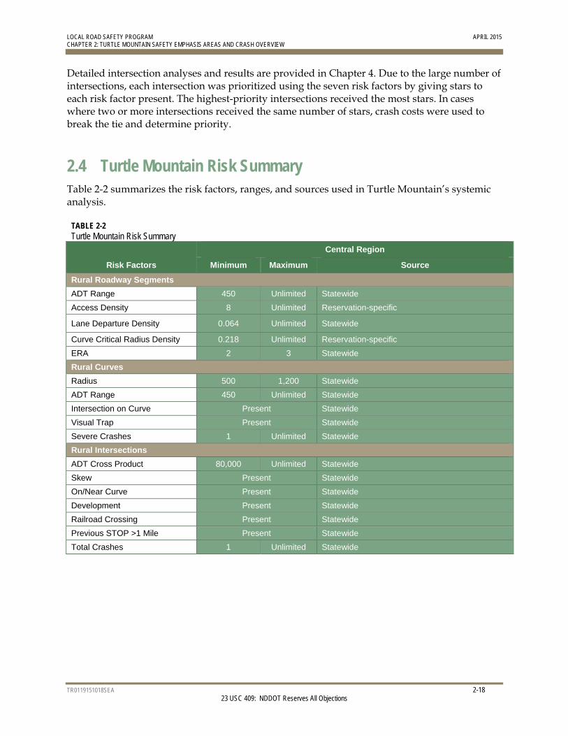
FIGURE 2-14 Statewide Rural Intersection Risk Factors Source: 2008-2012 (Phase 1 and Phase 2), 2009-2013 (Phase 3 and Phase 4)
Turtle Mountain had 27 total rural intersection crashes on the studied network from 2009 to 2013, and only 5 of those crashes were severe. Due to the small number of severe crashes, some of the data and risk factors may be misleading based on the reservation data alone. Therefore, national data were used to confirm intersection risk factors.
0%
10%
20%
30%
40%
50%
60%
70%
80%
0.000
0.002
0.004
0.006
0.008
0.010
0.012
0.014
Skew On/Near Curve Development Railroad Crossing > 5 Miles to Stop
Risk Factor
Severe Crash Density With Severe Crash Density Without
Severe Right Angle Crash Density With Severe Right Angle Crash Density Without
% Intersection w/ Risk Factor
LOCAL ROAD SAFETY PROGRAM APRIL 2015 CHAPTER 2: TURTLE MOUNTAIN SAFETY EMPHASIS AREAS AND CRASH OVERVIEW
TR0119151018SEA 2-18 23 USC 409: NDDOT Reserves All Objections
Detailed intersection analyses and results are provided in Chapter 4. Due to the large number of intersections, each intersection was prioritized using the seven risk factors by giving stars to each risk factor present. The highest-priority intersections received the most stars. In cases where two or more intersections received the same number of stars, crash costs were used to break the tie and determine priority.
2.4 Turtle Mountain Risk Summary Table 2-2 summarizes the risk factors, ranges, and sources used in Turtle Mountain’s systemic analysis.
TABLE 2-2 Turtle Mountain Risk Summary
Risk Factors
Central Region
Minimum Maximum Source
Rural Roadway Segments
ADT Range 450 Unlimited Statewide
Access Density 8 Unlimited Reservation-specific
Lane Departure Density 0.064 Unlimited Statewide
Curve Critical Radius Density 0.218 Unlimited Reservation-specific
ERA 2 3 Statewide
Rural Curves
Radius 500 1,200 Statewide
ADT Range 450 Unlimited Statewide
Intersection on Curve Present Statewide Visual Trap Present Statewide Severe Crashes 1 Unlimited Statewide
Rural Intersections
ADT Cross Product 80,000 Unlimited Statewide
Skew Present Statewide
On/Near Curve Present Statewide Development Present Statewide Railroad Crossing Present Statewide Previous STOP >1 Mile Present Statewide
Total Crashes 1 Unlimited Statewide
TR0119151018SEA 3-1 23 USC 409: NDDOT Reserves All Objections
3.0 Turtle Mountain Priority Safety Strategies
3.1 Background A variety of strategies are available to address each safety emphasis area. The implementation of high-priority strategies will assist state and local agencies in reducing traffic-related fatalities and incapacitating injuries. The primary sources for these strategies are the National Cooperative Highway Research Program (NCHRP) Report 500 series and the National Highway Traffic Safety Administration (NHTSA) Countermeasures That Work: A Highway Safety Countermeasure Guide for State Highway Safety Offices, (Seventh Edition, 2013). Each guide includes a description of the problem, strategies, and model implementation processes. In addition, to assist practitioners in assessing the safety strategies, the guides document the expected effectiveness of each strategy. NCHRP Report 500 series assigns strategies to one of the following categories:
Proven: These strategies have been used in multiple locations with multiple studies, and have been demonstrated to be effective.
Tried: These strategies have been implemented in many locations; however, no rigorous evaluations have been completed to determine their effectiveness.
Experimental: These strategies represent ideas that are considered to be effective; however, the ideas have not been widely implemented or evaluated.
3.2 Initial/Comprehensive List of Potential Strategies NCHRP safety strategies were the basis for identifying safety strategies for the LRSP. For the LRSP process, NDDOT team members sought to identify viable safety strategies for the top safety emphasis areas. The LRSP team reviewed the full range of safety strategies, and did an initial screening based on cost and effectiveness. For example, the NCHRP report lists over 70 potential strategies to address intersection safety. The screening conducted by the LRSP team narrowed the list of strategies for all safety emphasis areas down to strategies considered to be the most applicable in North Dakota.
Behavioral strategies, described in Chapter 5, include information on the expected effectiveness of the strategy to influence driver behavior based on current best practice and evaluation research results when available.
3.3 Prioritizing Safety Strategies The priority infrastructure safety strategies for the LRSP are:
Infrastructure strategies - Lane Departure: Provide enhanced shoulders, lighting, delineation (for example,
Chevrons), or pavement markings for sharp horizontal curves
- Lane Departure: Install edge rumble strips (shoulder or edge line)
- Lane Departure: Install enhanced pavement markings, 6‐inch edge line, or embedded wet‐reflective pavement markings on section with narrow or no paved shoulders
LOCAL ROAD SAFETY PROGRAM APRIL 2015 CHAPTER 3: TURTLE MOUNTAIN PRIORITY SAFETY STRATEGIES
TR0119151018SEA 3-2 23 USC 409: NDDOT Reserves All Objections
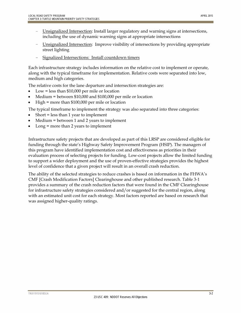
- Unsignalized Intersection: Install larger regulatory and warning signs at intersections, including the use of dynamic warning signs at appropriate intersections
- Unsignalized Intersection: Improve visibility of intersections by providing appropriate street lighting
- Signalized Intersections: Install countdown timers
Each infrastructure strategy includes information on the relative cost to implement or operate, along with the typical timeframe for implementation. Relative costs were separated into low, medium and high categories.
The relative costs for the lane departure and intersection strategies are: Low = less than $10,000 per mile or location Medium = between $10,000 and $100,000 per mile or location High = more than $100,000 per mile or location
The typical timeframe to implement the strategy was also separated into three categories: Short = less than 1 year to implement Medium = between 1 and 2 years to implement Long = more than 2 years to implement
Infrastructure safety projects that are developed as part of this LRSP are considered eligible for funding through the state’s Highway Safety Improvement Program (HSIP). The managers of this program have identified implementation cost and effectiveness as priorities in their evaluation process of selecting projects for funding. Low-cost projects allow the limited funding to support a wider deployment and the use of proven-effective strategies provides the highest level of confidence that a given project will result in an overall crash reduction.
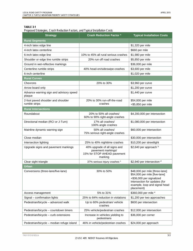
The ability of the selected strategies to reduce crashes is based on information in the FHWA’s CMF [Crash Modification Factors] Clearinghouse and other published research. Table 3-1 provides a summary of the crash reduction factors that were found in the CMF Clearinghouse for infrastructure safety strategies considered and/or suggested for the central region, along with an estimated unit cost for each strategy. Most factors reported are based on research that was assigned higher-quality ratings.
LOCAL ROAD SAFETY PROGRAM APRIL 2015 CHAPTER 3: TURTLE MOUNTAIN PRIORITY SAFETY STRATEGIES
TR0119151018SEA 3-3 23 USC 409: NDDOT Reserves All Objections
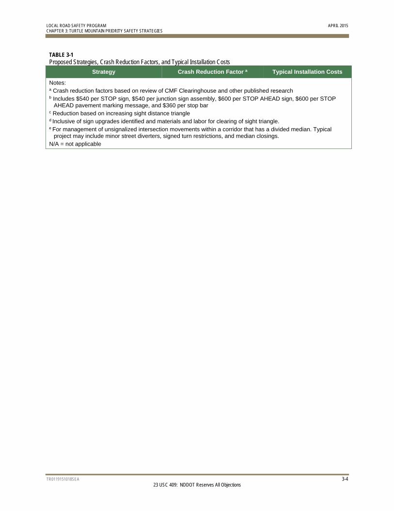
TABLE 3-1 Proposed Strategies, Crash Reduction Factors, and Typical Installation Costs
Strategy Crash Reduction Factor a Typical Installation Costs
Rural Segments
4-inch latex edge line $1,320 per mile
4-inch latex centerline $660 per mile
6-inch latex edge line 10% to 45% all rural serious crashes $1,980 per mile
Shoulder or edge line rumble strips 20% run off road crashes $5,850 per mile
Ground in wet-reflective markings $36,000 per mile
Centerline rumble strips 40% head-on/sideswipe-crashes $3,600 per mile
6-inch centerline $1,020 per mile
Rural Curves
Chevrons 20% to 30% $3,960 per curve
Arrow board only $1,200 per curve
Advance warning sign and advisory speed plaque
$1,440 per curve
2-foot paved shoulder and shoulder rumble strips
20% to 30% run-off-the-road crashes
$54,000 per mile +$5,850 per mile
Rural Intersections
Roundabout 20% to 50% all crashes/ 60% to 90% right-angle crashes
$4,200,000 per intersection
Directional median (RCI or J-Turn) 17% all crashes/ 100% angle crashes
$1,080,000 per intersection
Mainline dynamic warning sign 50% all crashes/ 75% serious right-angle crashes
$60,000 per intersection
Close median $30,000 per intersection
Intersection lighting 25% to 40% nighttime crashes $10,200 per streetlight
Upgrade signs and pavement markings 40% upgrade of all signs and pavement markings/
15% for STOP AHEAD pavement marking
$2,640 per approach b
Clear sight triangle 37% serious injury crashes c $2,940 per intersection d
Urban
Conversions (three-lane/five-lane) 30% to 50% $48,000 per mile [three-lane] $54,000 per mile [five-lane] +$36,000 per signalized intersection for updates (for example, loop and signal head placement)
Access management 5% to 31% $360,000 per mile e
Signal – confirmation lights 25% to 84% reduction in violations $1,200 per two approaches
Pedestrian/bicycle – advanced walk Up to 60% pedestrian/ vehicle crashes
$600 per intersection
Pedestrian/bicycle – countdown timers 25% vehicle/pedestrian crashes $12,000 per intersection
Pedestrian/bicycle – curb extensions Increase in vehicles yielding to pedestrians
$36,000 per corner
Pedestrian/bicycle – median refuge island 46% in vehicle/pedestrian crashes $24,000 per approach
LOCAL ROAD SAFETY PROGRAM APRIL 2015 CHAPTER 3: TURTLE MOUNTAIN PRIORITY SAFETY STRATEGIES
TR0119151018SEA 3-4 23 USC 409: NDDOT Reserves All Objections
TABLE 3-1 Proposed Strategies, Crash Reduction Factors, and Typical Installation Costs
Strategy Crash Reduction Factor a Typical Installation Costs
Notes: a Crash reduction factors based on review of CMF Clearinghouse and other published research b Includes $540 per STOP sign, $540 per junction sign assembly, $600 per STOP AHEAD sign, $600 per STOP
AHEAD pavement marking message, and $360 per stop bar c Reduction based on increasing sight distance triangle d Inclusive of sign upgrades identified and materials and labor for clearing of sight triangle. e For management of unsignalized intersection movements within a corridor that has a divided median. Typical
project may include minor street diverters, signed turn restrictions, and median closings. N/A = not applicable
LOCAL ROAD SAFETY PROGRAM APRIL 2015 CHAPTER 3: TURTLE MOUNTAIN PRIORITY SAFETY STRATEGIES
TR0119151018SEA 3-5 23 USC 409: NDDOT Reserves All Objections
3.4 Safety Strategies Workshop A Safety Planning Workshop was held as part of the LRSP process. The January 7, 2014 meeting in Bismarck included representatives from four of the Indian reservations in North Dakota, the Tribal Technical Assistance Program (TTAP), North Dakota Indian Affairs Commission, and the North Dakota Department of Transportation (NDDOT). The primary focus of the safety workshop was to discuss roadway safety concerns and initiatives, and to discuss the LRSP priority strategies outlined in Table 3-1.
The basic workshop structure included introductions and an overview of the current NDDOT safety program. Mark Nelson (Deputy Director, Driver and Vehicle Services) and Scott Davis (Director, North Dakota Indian Affairs Commission) shared information on funding, enforcement, data, and safety initiatives pertaining to Indian reservations in North Dakota.
Following the overview, the workshop participants discussed concerns and initiatives specific to each reservation, including updates on each tribal safety plan, which is now required by the Bureau of Indian Affairs (BIA) in order to receive funding. The final local speaker was Dennis Trusty of Northern Plains TTAP, who shared roadway safety resources pertaining to driver behavior issues.
Workshop participants included road safety engineering, traffic, enforcement, education, and NDDOT staff in order to include a variety of backgrounds and experiences to enable valuable interaction and discussions during the workshops.
TR0119151018SEA 23 USC 409: NDDOT Reserves All Objections
4.0 Turtle Mountain Infrastructure Safety Projects
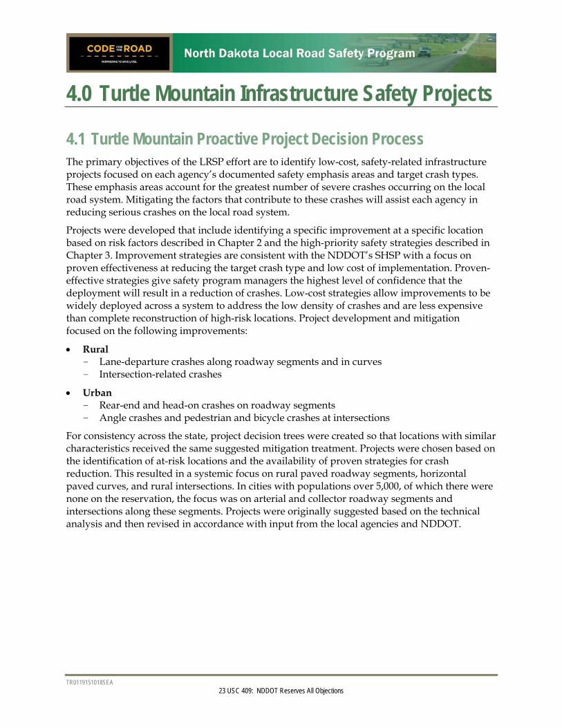
4.1 Turtle Mountain Proactive Project Decision Process The primary objectives of the LRSP effort are to identify low-cost, safety-related infrastructure projects focused on each agency’s documented safety emphasis areas and target crash types. These emphasis areas account for the greatest number of severe crashes occurring on the local road system. Mitigating the factors that contribute to these crashes will assist each agency in reducing serious crashes on the local road system.
Projects were developed that include identifying a specific improvement at a specific location based on risk factors described in Chapter 2 and the high-priority safety strategies described in Chapter 3. Improvement strategies are consistent with the NDDOT’s SHSP with a focus on proven effectiveness at reducing the target crash type and low cost of implementation. Proven-effective strategies give safety program managers the highest level of confidence that the deployment will result in a reduction of crashes. Low-cost strategies allow improvements to be widely deployed across a system to address the low density of crashes and are less expensive than complete reconstruction of high-risk locations. Project development and mitigation focused on the following improvements:
Rural - Lane-departure crashes along roadway segments and in curves - Intersection-related crashes
Urban - Rear-end and head-on crashes on roadway segments - Angle crashes and pedestrian and bicycle crashes at intersections
For consistency across the state, project decision trees were created so that locations with similar characteristics received the same suggested mitigation treatment. Projects were chosen based on the identification of at-risk locations and the availability of proven strategies for crash reduction. This resulted in a systemic focus on rural paved roadway segments, horizontal paved curves, and rural intersections. In cities with populations over 5,000, of which there were none on the reservation, the focus was on arterial and collector roadway segments and intersections along these segments. Projects were originally suggested based on the technical analysis and then revised in accordance with input from the local agencies and NDDOT.
LOCAL ROAD SAFETY PROGRAM APRIL 2015 CHAPTER 4: TURTLE MOUNTAIN INFRASTRUCTURE SAFETY PROJECTS
TR0119151018SEA 4-2 23 USC 409: NDDOT Reserves All Objections
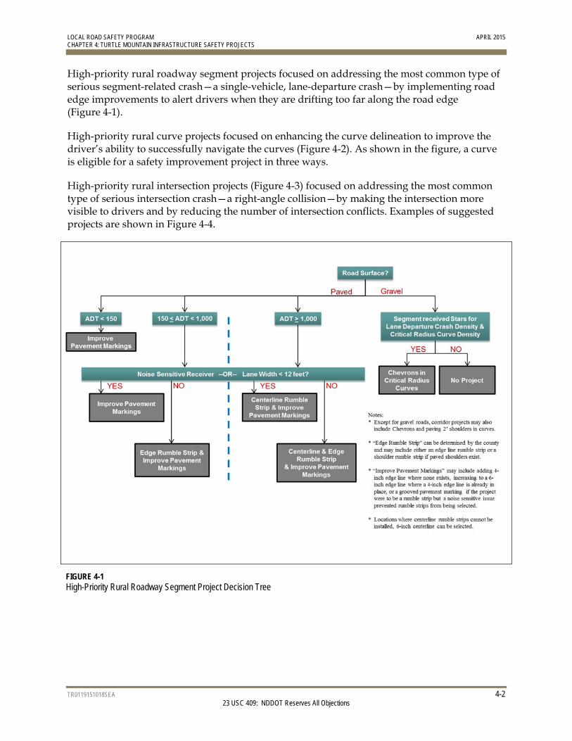
High-priority rural roadway segment projects focused on addressing the most common type of serious segment-related crash—a single-vehicle, lane-departure crash—by implementing road edge improvements to alert drivers when they are drifting too far along the road edge (Figure 4-1).
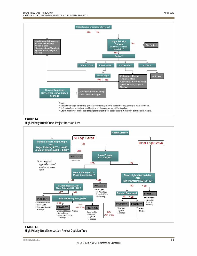
High-priority rural curve projects focused on enhancing the curve delineation to improve the driver’s ability to successfully navigate the curves (Figure 4-2). As shown in the figure, a curve is eligible for a safety improvement project in three ways.
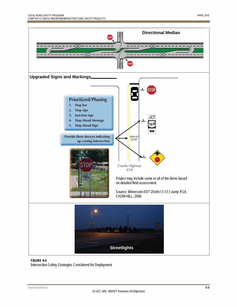
High-priority rural intersection projects (Figure 4-3) focused on addressing the most common type of serious intersection crash—a right-angle collision—by making the intersection more visible to drivers and by reducing the number of intersection conflicts. Examples of suggested projects are shown in Figure 4-4.
FIGURE 4-1 High-Priority Rural Roadway Segment Project Decision Tree
LOCAL ROAD SAFETY PROGRAM APRIL 2015 CHAPTER 4: TURTLE MOUNTAIN INFRASTRUCTURE SAFETY PROJECTS
TR0119151018SEA 4-3 23 USC 409: NDDOT Reserves All Objections
FIGURE 4-2 High-Priority Rural Curve Project Decision Tree
FIGURE 4-3 High-Priority Rural Intersection Project Decision Tree
LOCAL ROAD SAFETY PROGRAM APRIL 2015 CHAPTER 4: TURTLE MOUNTAIN INFRASTRUCTURE SAFETY PROJECTS
TR0119151018SEA 4-4 23 USC 409: NDDOT Reserves All Objections
FIGURE 4-4 Intersection Safety Strategies Considered for Deployment
Directional Median
Upgraded Signs and Markings
Project may include some or all of the items based on detailed field assessment. Source: Minnesota DOT District 3-13 County RSA, CH2M HILL, 2006
Streetlights
LOCAL ROAD SAFETY PROGRAM APRIL 2015 CHAPTER 4: TURTLE MOUNTAIN INFRASTRUCTURE SAFETY PROJECTS
TR0119151018SEA 4-5 23 USC 409: NDDOT Reserves All Objections
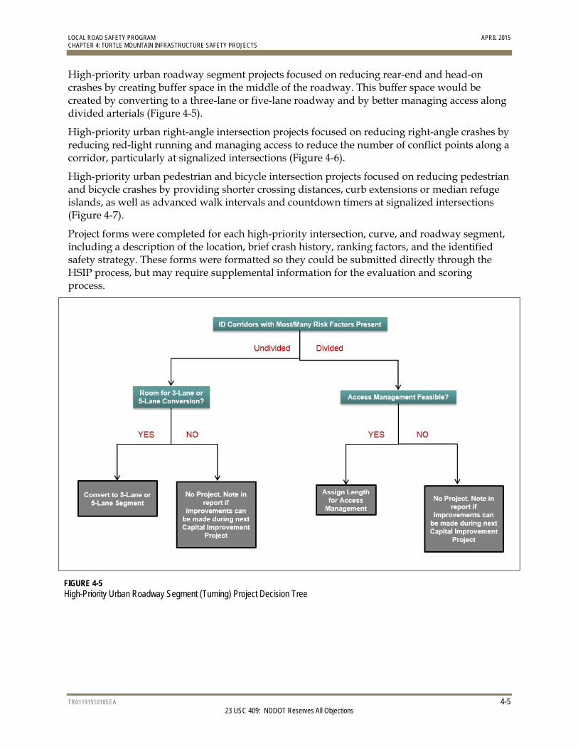
High-priority urban roadway segment projects focused on reducing rear-end and head-on crashes by creating buffer space in the middle of the roadway. This buffer space would be created by converting to a three-lane or five-lane roadway and by better managing access along divided arterials (Figure 4-5).
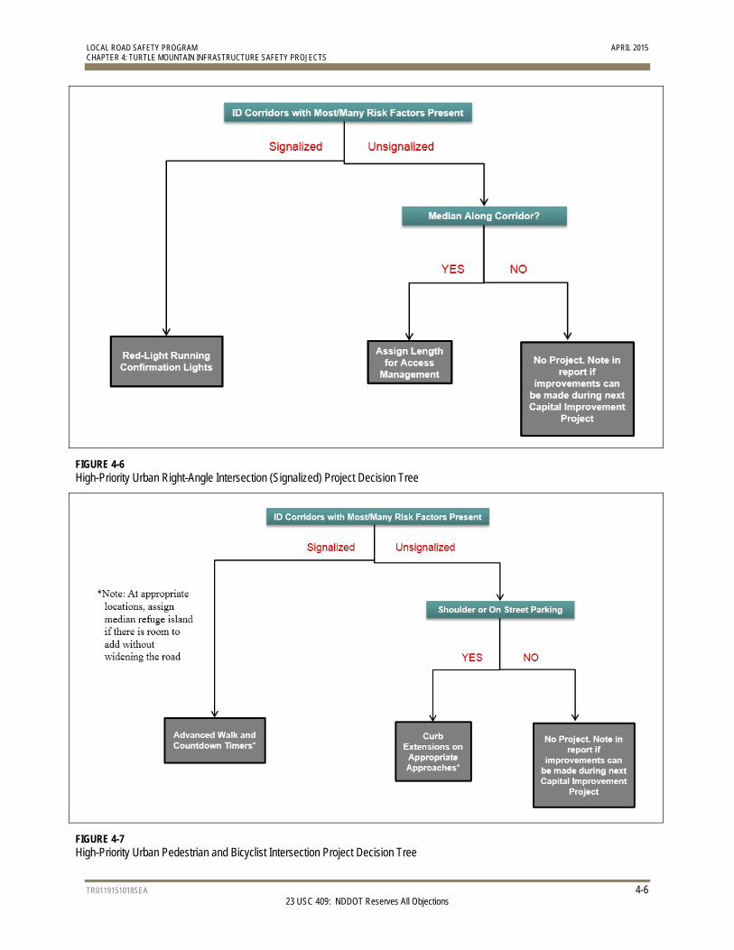
High-priority urban right-angle intersection projects focused on reducing right-angle crashes by reducing red-light running and managing access to reduce the number of conflict points along a corridor, particularly at signalized intersections (Figure 4-6).
High-priority urban pedestrian and bicycle intersection projects focused on reducing pedestrian and bicycle crashes by providing shorter crossing distances, curb extensions or median refuge islands, as well as advanced walk intervals and countdown timers at signalized intersections (Figure 4-7).
Project forms were completed for each high-priority intersection, curve, and roadway segment, including a description of the location, brief crash history, ranking factors, and the identified safety strategy. These forms were formatted so they could be submitted directly through the HSIP process, but may require supplemental information for the evaluation and scoring process.
FIGURE 4-5 High-Priority Urban Roadway Segment (Turning) Project Decision Tree
LOCAL ROAD SAFETY PROGRAM APRIL 2015 CHAPTER 4: TURTLE MOUNTAIN INFRASTRUCTURE SAFETY PROJECTS
TR0119151018SEA 4-6 23 USC 409: NDDOT Reserves All Objections
FIGURE 4-6 High-Priority Urban Right-Angle Intersection (Signalized) Project Decision Tree
FIGURE 4-7 High-Priority Urban Pedestrian and Bicyclist Intersection Project Decision Tree
LOCAL ROAD SAFETY PROGRAM APRIL 2015 CHAPTER 4: TURTLE MOUNTAIN INFRASTRUCTURE SAFETY PROJECTS
TR0119151018SEA 4-7 23 USC 409: NDDOT Reserves All Objections
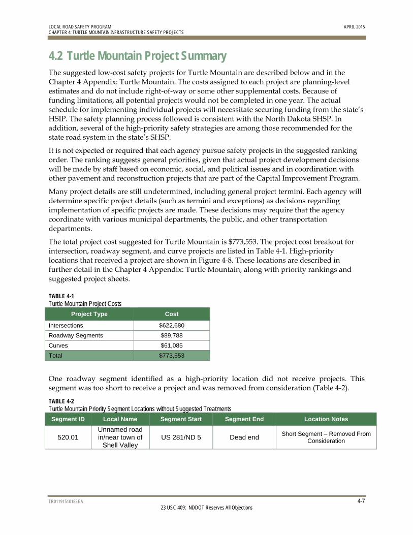
4.2 Turtle Mountain Project Summary The suggested low-cost safety projects for Turtle Mountain are described below and in the Chapter 4 Appendix: Turtle Mountain. The costs assigned to each project are planning-level estimates and do not include right-of-way or some other supplemental costs. Because of funding limitations, all potential projects would not be completed in one year. The actual schedule for implementing individual projects will necessitate securing funding from the state’s HSIP. The safety planning process followed is consistent with the North Dakota SHSP. In addition, several of the high-priority safety strategies are among those recommended for the state road system in the state’s SHSP.
It is not expected or required that each agency pursue safety projects in the suggested ranking order. The ranking suggests general priorities, given that actual project development decisions will be made by staff based on economic, social, and political issues and in coordination with other pavement and reconstruction projects that are part of the Capital Improvement Program.
Many project details are still undetermined, including general project termini. Each agency will determine specific project details (such as termini and exceptions) as decisions regarding implementation of specific projects are made. These decisions may require that the agency coordinate with various municipal departments, the public, and other transportation departments.
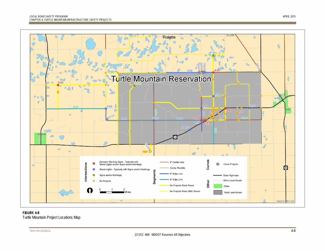
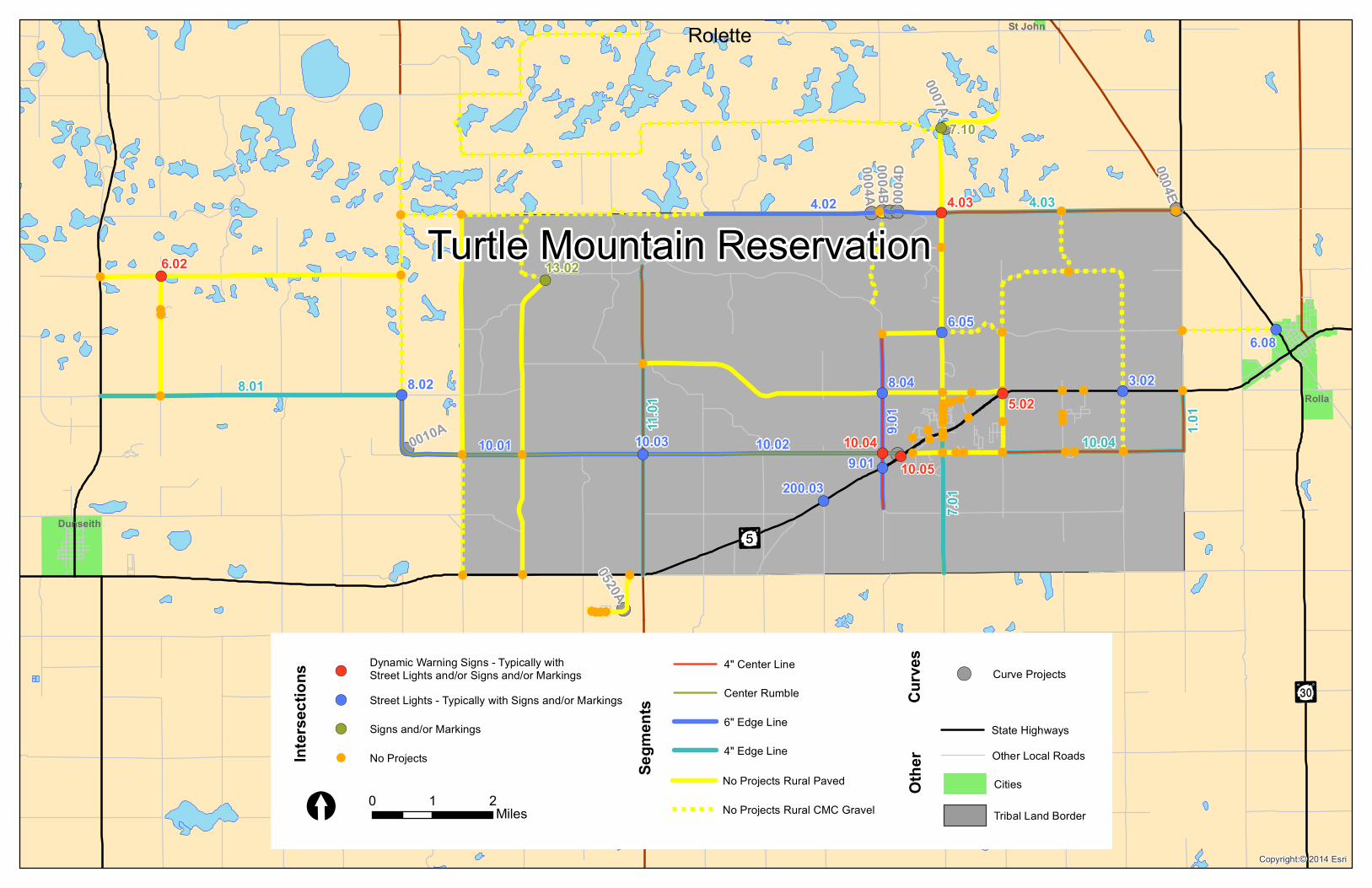
The total project cost suggested for Turtle Mountain is $773,553. The project cost breakout for intersection, roadway segment, and curve projects are listed in Table 4-1. High-priority locations that received a project are shown in Figure 4-8. These locations are described in further detail in the Chapter 4 Appendix: Turtle Mountain, along with priority rankings and suggested project sheets.
TABLE 4-1 Turtle Mountain Project Costs
Project Type Cost
Intersections $622,680
Roadway Segments $89,788
Curves $61,085
Total $773,553
One roadway segment identified as a high-priority location did not receive projects. This segment was too short to receive a project and was removed from consideration (Table 4-2).
TABLE 4-2 Turtle Mountain Priority Segment Locations without Suggested Treatments
Segment ID Local Name Segment Start Segment End Location Notes
520.01 Unnamed road in/near town of
Shell Valley US 281/ND 5 Dead end Short Segment – Removed From
Consideration
LOCAL ROAD SAFETY PROGRAM APRIL 2015 CHAPTER 4: TURTLE MOUNTAIN INFRASTRUCTURE SAFETY PROJECTS
TR0119151018SEA 4-8 23 USC 409: NDDOT Reserves All Objections
FIGURE 4-8 Turtle Mountain Project Locations Map
LOCAL ROAD SAFETY PROGRAM APRIL 2015 APPENDIX - CHAPTER 4: TURTLE MOUNTAIN INFRASTRUCTURE SAFETY PROJECTS
APPENDIX
Turtle Mountain Reservation
23 USC 409
NDDOT Reserves All Objections
!(
!(
!( !(
!(!(!(!( !(
!
!!
!
!!
!!
!
!!
!!!!!!!!
!!!!
!(
!!
!!
! !(
! ! !(
!
!
!(
!(
!(
!
! !
!! !
!!!( !
!!! !(
!(
!
!
!
!
!
!(
!(
!
!! !(
!
!
!(
!
!!
!(
!(
P¿
P¤
Rolette
0004A
0004E0004
D0004B
0520A
0007A0010A
Rolla
St John
Dunseith
4.03
8.01
10.04
7.01
11.01
1.01
9.01
10.02
4.02
10.01
7.10
13.02
200.03
8.02
10.03
6.05
8.04
9.01
6.08
3.02
10.0410.05
5.02
4.03
6.02
Copyright:© 2014 Esri
Turtle Mountain ReservationInt
ersec
tions
!( Street Lights - Typically with Signs and/or Markings
!( Signs and/or Markings
! No Projects
Center Rumble
4" Edge Line
No Projects Rural Paved
No Projects Rural CMC Gravel
!( Curve Projects
Segm
ents
!(Dynamic Warning Signs - Typically withStreet Lights and/or Signs and/or Markings
Othe
rCu
rves
0 1 2Miles[Cities
Other Local RoadsState Highways6" Edge Line
4" Center Line
Tribal Land Border
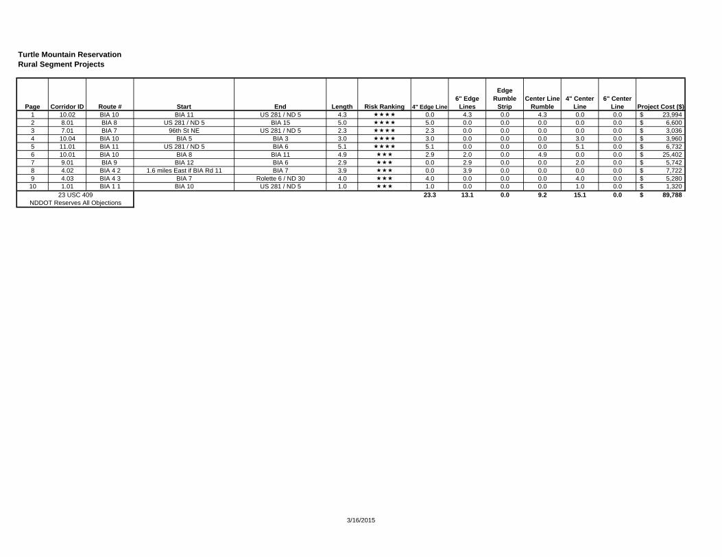
Turtle Mountain ReservationRural Segment Projects
1 10.02 BIA 10 BIA 11 US 281 / ND 5 4.3 0.0 4.3 0.0 4.3 0.0 0.0 23,994$ 2 8.01 BIA 8 US 281 / ND 5 BIA 15 5.0 5.0 0.0 0.0 0.0 0.0 0.0 6,600$ 3 7.01 BIA 7 96th St NE US 281 / ND 5 2.3 2.3 0.0 0.0 0.0 0.0 0.0 3,036$ 4 10.04 BIA 10 BIA 5 BIA 3 3.0 3.0 0.0 0.0 0.0 3.0 0.0 3,960$ 5 11.01 BIA 11 US 281 / ND 5 BIA 6 5.1 5.1 0.0 0.0 0.0 5.1 0.0 6,732$ 6 10.01 BIA 10 BIA 8 BIA 11 4.9 2.9 2.0 0.0 4.9 0.0 0.0 25,402$ 7 9.01 BIA 9 BIA 12 BIA 6 2.9 0.0 2.9 0.0 0.0 2.0 0.0 5,742$ 8 4.02 BIA 4 2 1.6 miles East if BIA Rd 11 BIA 7 3.9 0.0 3.9 0.0 0.0 0.0 0.0 7,722$ 9 4.03 BIA 4 3 BIA 7 Rolette 6 / ND 30 4.0 4.0 0.0 0.0 0.0 4.0 0.0 5,280$ 10 1.01 BIA 1 1 BIA 10 US 281 / ND 5 1.0 1.0 0.0 0.0 0.0 1.0 0.0 1,320$
23.3 13.1 0.0 9.2 15.1 0.0 89,788$ NDDOT Reserves All Objections
23 USC 409
Center Line Rumble
6" Center Line Project Cost ($)
Edge Rumble
StripPage Corridor ID Route #6" Edge
LinesStart End Length Risk Ranking 4" Edge Line
4" Center Line
3/16/2015
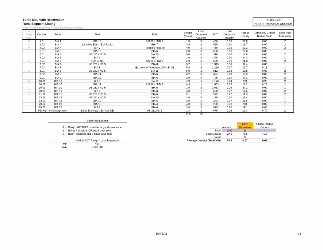
Turtle Mountain ReservationRural Segment Listing*High Priority Segments Project Sheet Page Number
10 1.01 BIA 1 BIA 10 US 281 / ND 5 1.0 0 450 0.00 27.0 0.00 28 4.02 BIA 4 1.6 miles East if BIA Rd 11 BIA 7 3.9 0 525 0.00 11.7 0.00 29 4.03 BIA 4 BIA 7 Rolette 6 / ND 30 4.0 1 460 0.05 13.3 0.00 2
5.01 BIA 5 BIA 10 BIA 6 2.0 0 520 0.00 22.0 0.00 16.01 BIA 6 US 281 / ND 5 BIA 15 5.0 0 310 0.00 14.6 0.00 26.02 BIA 6 BIA 9 BIA 7 1.0 0 490 0.00 44.3 0.00 1
3 7.01 BIA 7 96th St NE US 281 / ND 5 2.3 1 690 0.09 21.8 0.00 27.02 BIA 7 US 281 / ND 5 BIA 8 0.7 1 1,975 0.30 37.4 0.00 17.03 BIA 7 BIA 8 East end of Southern 105th St NE 5.4 2 1,210 0.07 12.7 0.18 1
2 8.01 BIA 8 US 281 / ND 5 BIA 15 5.0 2 812 0.08 13.8 0.00 28.02 BIA 8 BIA 11 BIA 5 6.2 0 324 0.00 15.9 0.00 2
7 9.01 BIA 9 BIA 12 BIA 6 2.9 0 705 0.00 24.1 0.00 26 10.01 BIA 10 BIA 8 BIA 11 4.9 1 1,170 0.04 9.9 0.20 21 10.02 BIA 10 BIA 11 US 281 / ND 5 4.3 1 1,563 0.05 13.2 0.23 2
10.03 BIA 10 US 281 / ND 5 BIA 5 1.5 2 1,633 0.26 37.1 0.00 14 10.04 BIA 10 BIA 5 BIA 3 3.0 1 600 0.07 15.6 0.00 25 11.01 BIA 11 US 281 / ND 5 BIA 6 5.1 7 572 0.27 11.3 0.00 2
13.01 BIA 13 US 281 / ND 5 BIA 10 2.0 0 170 0.00 11.4 0.00 113.02 BIA 13 BIA 10 BIA 6 3.0 1 222 0.07 11.5 0.00 123.02 BIA 23 BIA 10 BIA 4 4.0 0 200 0.00 9.0 0.00 125.01 BIA 25 BIA 8 BIA 6 2.0 2 525 0.20 19.1 0.00 1
520.01 No Designation Dead End near 38th Ave NE US 281/ND 5 1.3 1 675 0.16 10.3 0.79 270.5 23
Edge Risk Legend
3 -- Risky' - NEITHER shoulder or good clear zone AccessLane
DepartureCritical Radius
Curves2 -- Either a shoulder OR good clear zone Total 1082 23 41 -- BOTH shoulder and a good clear zone Total Mileage 70.5 70.5 70.5
Years 5Critical ADT Range - Lane Departure Average Density (Total/Mile) 15.3 0.07 0.06
Min 450Max 1,000,000
Project Sheet Page*
Edge Risk Assesment
Length (miles)
Lane Departure Crashes
CorridorCurves w/ Critical
Radius / MileEndStartRoute
Access Density
23 USC 409
NDDOT Reserves All Objections
ADTLane
Departure Density
3/16/2015 1/2
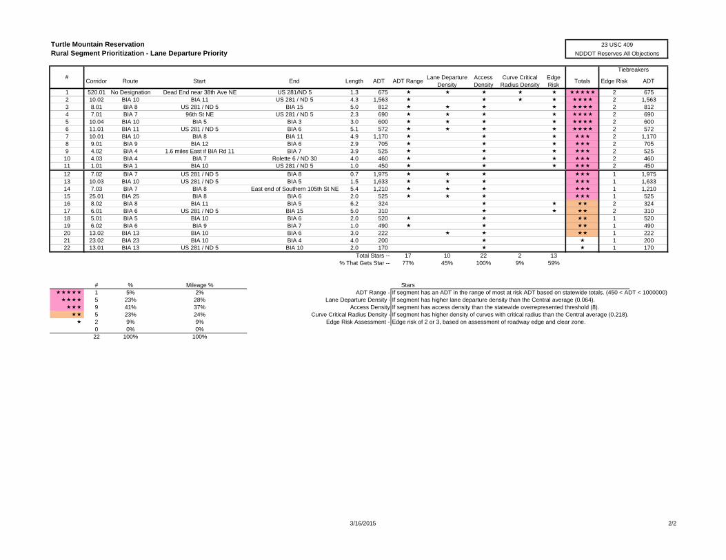
Turtle Mountain ReservationRural Segment Prioritization - Lane Departure Priority
Corridor Route Start End Length ADT ADT RangeLane Departure
DensityAccess Density
Curve CriticalRadius Density
Edge Risk
Totals Edge Risk ADT
1 520.01 No Designation Dead End near 38th Ave NE US 281/ND 5 1.3 675 2 6752 10.02 BIA 10 BIA 11 US 281 / ND 5 4.3 1,563 2 1,5633 8.01 BIA 8 US 281 / ND 5 BIA 15 5.0 812 2 8124 7.01 BIA 7 96th St NE US 281 / ND 5 2.3 690 2 6905 10.04 BIA 10 BIA 5 BIA 3 3.0 600 2 6006 11.01 BIA 11 US 281 / ND 5 BIA 6 5.1 572 2 5727 10.01 BIA 10 BIA 8 BIA 11 4.9 1,170 2 1,1708 9.01 BIA 9 BIA 12 BIA 6 2.9 705 2 7059 4.02 BIA 4 1.6 miles East if BIA Rd 11 BIA 7 3.9 525 2 525
10 4.03 BIA 4 BIA 7 Rolette 6 / ND 30 4.0 460 2 46011 1.01 BIA 1 BIA 10 US 281 / ND 5 1.0 450 2 450
12 7.02 BIA 7 US 281 / ND 5 BIA 8 0.7 1,975 1 1,97513 10.03 BIA 10 US 281 / ND 5 BIA 5 1.5 1,633 1 1,63314 7.03 BIA 7 BIA 8 East end of Southern 105th St NE 5.4 1,210 1 1,21015 25.01 BIA 25 BIA 8 BIA 6 2.0 525 1 52516 8.02 BIA 8 BIA 11 BIA 5 6.2 324 2 32417 6.01 BIA 6 US 281 / ND 5 BIA 15 5.0 310 2 31018 5.01 BIA 5 BIA 10 BIA 6 2.0 520 1 52019 6.02 BIA 6 BIA 9 BIA 7 1.0 490 1 49020 13.02 BIA 13 BIA 10 BIA 6 3.0 222 1 22221 23.02 BIA 23 BIA 10 BIA 4 4.0 200 1 20022 13.01 BIA 13 US 281 / ND 5 BIA 10 2.0 170 1 170
Total Stars -- 17 10 22 2 13% That Gets Star -- 77% 45% 100% 9% 59%
# % Mileage % Stars 1 5% 2% ADT Range - If segment has an ADT in the range of most at risk ADT based on statewide totals. (450 < ADT < 1000000) 5 23% 28% Lane Departure Density - If segment has higher lane departure density than the Central average (0.064). 9 41% 37% Access Density If segment has access density than the statewide overrepresented threshold (8). 5 23% 24% Curve Critical Radius Density - If segment has higher density of curves with critical radius than the Central average (0.218). 2 9% 9% Edge Risk Assessment - Edge risk of 2 or 3, based on assessment of roadway edge and clear zone.
0 0% 0%22 100% 100%
23 USC 409
NDDOT Reserves All Objections
# Tiebreakers
3/16/2015 2/2

HIGHWAY SAFETY IMPROVEMENT PROGRAM (HSIP) PROJECT APPLICATIONNorth Dakota Department of Transportation ProgrammingSFN 59959 (06-2011)
Agency Name: Turtle Mountain Reservation ND DOT District: 3Contact Name: Ron Trottier Work: 701-477-0407 Ext. 223Email Address: [email protected]
Please attach a location map(s). You may use additional sheets to further describe your project.
Location Description
Start: BIA 11 Lane Width: 11'End: US 281 / ND 5 Speed Limit: High
Facility Type: 2-Lane Shoulder Width: 0'ADT: 1563 Shoulder Type: None
Road Type Rural Paved Length (miles): 4.3County Road BIA 10 Rumble Installed: NoLocal Name: BIA 10 Oil Project: No
Describe Current Safety Issues & Systemic Ranking ReviewNorth Dakota Crashes, 2009-2013 5 years
Total Road Dept K+ACrashes 6 1 3
Density (per mile per year) 0.28 0.05 0.14Rate (per MVM) 0.49 0.08 0.24
Value Critical Departure ADT Range 1,563 450≤ADT≤1000000 RD Density 0.046 0.064
Access Density 13.2 8.0 Curve Critical Radius Density 0.232 0.218
Edge Risk 2 2 or 3
Describe Proposed Safety Improvements
Description Type Cost per mi Mileage Cost4" Edge Lines Proactive 1,320$ 0.0 -$ 6" Edge Lines Proactive 1,980$ 4.3 8,514$
Edge Rumble Strip Proactive 5,850$ 0.0 -$ Ground In Wet-Reflective Markings Proactive 36,000$ 0.0 -$
Center Line Rumble Strip Proactive 3,600$ 4.3 15,480$ 4" Center Line Proactive 660$ 0.0 -$ 6" Center Line Proactive 1,020$ 0.0 -$
Project Cost Estimate (attach detailed copy) Proposed Year of Construction
Federal Funds $ 21,595 Local Match (10% of Total project cost) 2,399$
Total Project Cost 23,994$
NDDOT Central Office Only
Project Accepted? Reference Number ID NumberNotes
Page: 1
23 USC 409 Segment ID: 10.02
NDDOT Reserves All Objections Date: 3/16/2015
Curb Aggressive DrivingImprovements to Address Lane Departure CrashesEnhancing Emergency Medical Capabilities to Increase SurvivabilityImprove Intersection Safety
Notes -
BIA 10 from BIA 11 to US 281 / ND 5
Telephone Number:
SHSP Emphasis Area (check all that apply)Reduce Alcohol Impaired DrivingIncrease the Use of Safety Restraints for all OccupantsYounger Driver/Older Driver Safety
Yes No
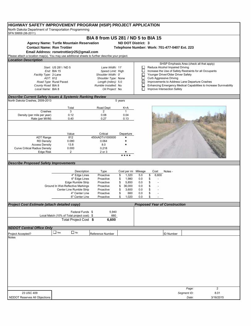
HIGHWAY SAFETY IMPROVEMENT PROGRAM (HSIP) PROJECT APPLICATIONNorth Dakota Department of Transportation ProgrammingSFN 59959 (06-2011)
Agency Name: Turtle Mountain Reservation ND DOT District: 3Contact Name: Ron Trottier Work: 701-477-0407 Ext. 223Email Address: [email protected]
Please attach a location map(s). You may use additional sheets to further describe your project.
Location Description
Start: US 281 / ND 5 Lane Width: 11'End: BIA 15 Speed Limit: High
Facility Type: 2-Lane Shoulder Width: 0'ADT: 812 Shoulder Type: None
Road Type Rural Paved Length (miles): 5.0County Road BIA 8 Rumble Installed: NoLocal Name: BIA 8 Oil Project: No
Describe Current Safety Issues & Systemic Ranking ReviewNorth Dakota Crashes, 2009-2013 5 years
Total Road Dept K+ACrashes 3 2 1
Density (per mile per year) 0.12 0.08 0.04Rate (per MVM) 0.40 0.27 0.13
Value Critical Departure ADT Range 812 450≤ADT≤1000000 RD Density 0.080 0.064
Access Density 13.8 8.0 Curve Critical Radius Density 0.000 0.218
Edge Risk 2 2 or 3
Describe Proposed Safety Improvements
Description Type Cost per mi Mileage Cost4" Edge Lines Proactive 1,320$ 5.0 6,600$ 6" Edge Lines Proactive 1,980$ 0.0 -$
Edge Rumble Strip Proactive 5,850$ 0.0 -$ Ground In Wet-Reflective Markings Proactive 36,000$ 0.0 -$
Center Line Rumble Strip Proactive 3,600$ 0.0 -$ 4" Center Line Proactive 660$ 0.0 -$ 6" Center Line Proactive 1,020$ 0.0 -$
Project Cost Estimate (attach detailed copy) Proposed Year of Construction
Federal Funds $ 5,940 Local Match (10% of Total project cost) 660$
Total Project Cost 6,600$
NDDOT Central Office Only
Project Accepted? Reference Number ID NumberNotes
Page: 2
23 USC 409 Segment ID: 8.01
NDDOT Reserves All Objections Date: 3/16/2015
Curb Aggressive DrivingImprovements to Address Lane Departure CrashesEnhancing Emergency Medical Capabilities to Increase SurvivabilityImprove Intersection Safety
Notes -
BIA 8 from US 281 / ND 5 to BIA 15
Telephone Number:
SHSP Emphasis Area (check all that apply)Reduce Alcohol Impaired DrivingIncrease the Use of Safety Restraints for all OccupantsYounger Driver/Older Driver Safety
Yes No
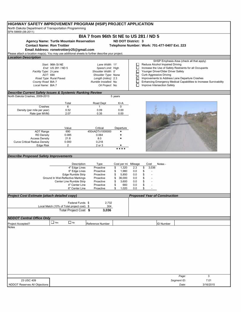
HIGHWAY SAFETY IMPROVEMENT PROGRAM (HSIP) PROJECT APPLICATIONNorth Dakota Department of Transportation ProgrammingSFN 59959 (06-2011)
Agency Name: Turtle Mountain Reservation ND DOT District: 3Contact Name: Ron Trottier Work: 701-477-0407 Ext. 223Email Address: [email protected]
Please attach a location map(s). You may use additional sheets to further describe your project.
Location Description
Start: 96th St NE Lane Width: 11'End: US 281 / ND 5 Speed Limit: High
Facility Type: 2-Lane Shoulder Width: 0'ADT: 690 Shoulder Type: None
Road Type Rural Paved Length (miles): 2.3County Road BIA 7 Rumble Installed: NoLocal Name: BIA 7 Oil Project: No
Describe Current Safety Issues & Systemic Ranking ReviewNorth Dakota Crashes, 2009-2013 5 years
Total Road Dept K+ACrashes 6 1 0
Density (per mile per year) 0.52 0.09 0.00Rate (per MVM) 2.07 0.35 0.00
Value Critical Departure ADT Range 690 450≤ADT≤1000000 RD Density 0.085 0.064
Access Density 21.8 8.0 Curve Critical Radius Density 0.000 0.218
Edge Risk 2 2 or 3
Describe Proposed Safety Improvements
Description Type Cost per mi Mileage Cost4" Edge Lines Proactive 1,320$ 2.3 3,036$ 6" Edge Lines Proactive 1,980$ 0.0 -$
Edge Rumble Strip Proactive 5,850$ 0.0 -$ Ground In Wet-Reflective Markings Proactive 36,000$ 0.0 -$
Center Line Rumble Strip Proactive 3,600$ 0.0 -$ 4" Center Line Proactive 660$ 0.0 -$ 6" Center Line Proactive 1,020$ 0.0 -$
Project Cost Estimate (attach detailed copy) Proposed Year of Construction
Federal Funds $ 2,732 Local Match (10% of Total project cost) 304$
Total Project Cost 3,036$
NDDOT Central Office Only
Project Accepted? Reference Number ID NumberNotes
Page: 3
23 USC 409 Segment ID: 7.01
NDDOT Reserves All Objections Date: 3/16/2015
Curb Aggressive DrivingImprovements to Address Lane Departure CrashesEnhancing Emergency Medical Capabilities to Increase SurvivabilityImprove Intersection Safety
Notes -
BIA 7 from 96th St NE to US 281 / ND 5
Telephone Number:
SHSP Emphasis Area (check all that apply)Reduce Alcohol Impaired DrivingIncrease the Use of Safety Restraints for all OccupantsYounger Driver/Older Driver Safety
Yes No
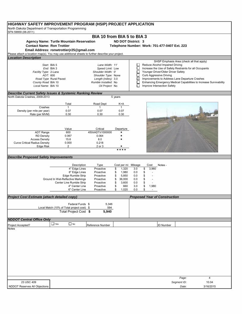
HIGHWAY SAFETY IMPROVEMENT PROGRAM (HSIP) PROJECT APPLICATIONNorth Dakota Department of Transportation ProgrammingSFN 59959 (06-2011)
Agency Name: Turtle Mountain Reservation ND DOT District: 3Contact Name: Ron Trottier Work: 701-477-0407 Ext. 223Email Address: [email protected]
Please attach a location map(s). You may use additional sheets to further describe your project.
Location Description
Start: BIA 5 Lane Width: 11'End: BIA 3 Speed Limit: Low
Facility Type: 2-Lane Shoulder Width: 0'ADT: 600 Shoulder Type: None
Road Type Rural Paved Length (miles): 3.0County Road BIA 10 Rumble Installed: NoLocal Name: BIA 10 Oil Project: No
Describe Current Safety Issues & Systemic Ranking ReviewNorth Dakota Crashes, 2009-2013 5 years
Total Road Dept K+ACrashes 1 1 1
Density (per mile per year) 0.07 0.07 0.07Rate (per MVM) 0.30 0.30 0.30
Value Critical Departure ADT Range 600 450≤ADT≤1000000 RD Density 0.067 0.064
Access Density 15.6 8.0 Curve Critical Radius Density 0.000 0.218
Edge Risk 2 2 or 3
Describe Proposed Safety Improvements
Description Type Cost per mi Mileage Cost4" Edge Lines Proactive 1,320$ 3.0 3,960$ 6" Edge Lines Proactive 1,980$ 0.0 -$
Edge Rumble Strip Proactive 5,850$ 0.0 -$ Ground In Wet-Reflective Markings Proactive 36,000$ 0.0 -$
Center Line Rumble Strip Proactive 3,600$ 0.0 -$ 4" Center Line Proactive 660$ 3.0 1,980$ 6" Center Line Proactive 1,020$ 0.0 -$
Project Cost Estimate (attach detailed copy) Proposed Year of Construction
Federal Funds $ 5,346 Local Match (10% of Total project cost) 594$
Total Project Cost 5,940$
NDDOT Central Office Only
Project Accepted? Reference Number ID NumberNotes
Page: 4
23 USC 409 Segment ID: 10.04
NDDOT Reserves All Objections Date: 3/16/2015
Curb Aggressive DrivingImprovements to Address Lane Departure CrashesEnhancing Emergency Medical Capabilities to Increase SurvivabilityImprove Intersection Safety
Notes -
BIA 10 from BIA 5 to BIA 3
Telephone Number:
SHSP Emphasis Area (check all that apply)Reduce Alcohol Impaired DrivingIncrease the Use of Safety Restraints for all OccupantsYounger Driver/Older Driver Safety
Yes No
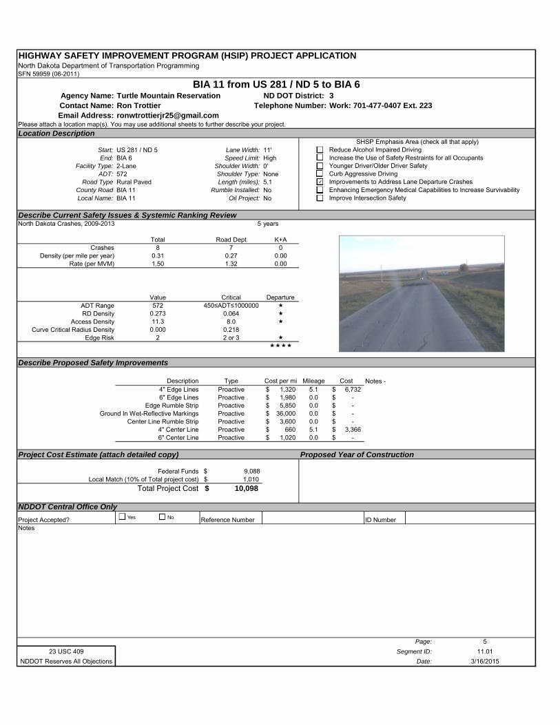
HIGHWAY SAFETY IMPROVEMENT PROGRAM (HSIP) PROJECT APPLICATIONNorth Dakota Department of Transportation ProgrammingSFN 59959 (06-2011)
Agency Name: Turtle Mountain Reservation ND DOT District: 3Contact Name: Ron Trottier Work: 701-477-0407 Ext. 223Email Address: [email protected]
Please attach a location map(s). You may use additional sheets to further describe your project.
Location Description
Start: US 281 / ND 5 Lane Width: 11'End: BIA 6 Speed Limit: High
Facility Type: 2-Lane Shoulder Width: 0'ADT: 572 Shoulder Type: None
Road Type Rural Paved Length (miles): 5.1County Road BIA 11 Rumble Installed: NoLocal Name: BIA 11 Oil Project: No
Describe Current Safety Issues & Systemic Ranking ReviewNorth Dakota Crashes, 2009-2013 5 years
Total Road Dept K+ACrashes 8 7 0
Density (per mile per year) 0.31 0.27 0.00Rate (per MVM) 1.50 1.32 0.00
Value Critical Departure ADT Range 572 450≤ADT≤1000000 RD Density 0.273 0.064
Access Density 11.3 8.0 Curve Critical Radius Density 0.000 0.218
Edge Risk 2 2 or 3
Describe Proposed Safety Improvements
Description Type Cost per mi Mileage Cost4" Edge Lines Proactive 1,320$ 5.1 6,732$ 6" Edge Lines Proactive 1,980$ 0.0 -$
Edge Rumble Strip Proactive 5,850$ 0.0 -$ Ground In Wet-Reflective Markings Proactive 36,000$ 0.0 -$
Center Line Rumble Strip Proactive 3,600$ 0.0 -$ 4" Center Line Proactive 660$ 5.1 3,366$ 6" Center Line Proactive 1,020$ 0.0 -$
Project Cost Estimate (attach detailed copy) Proposed Year of Construction
Federal Funds $ 9,088 Local Match (10% of Total project cost) 1,010$
Total Project Cost 10,098$
NDDOT Central Office Only
Project Accepted? Reference Number ID NumberNotes
Page: 5
23 USC 409 Segment ID: 11.01
NDDOT Reserves All Objections Date: 3/16/2015
BIA 11 from US 281 / ND 5 to BIA 6
Telephone Number:
SHSP Emphasis Area (check all that apply)Reduce Alcohol Impaired DrivingIncrease the Use of Safety Restraints for all OccupantsYounger Driver/Older Driver SafetyCurb Aggressive DrivingImprovements to Address Lane Departure CrashesEnhancing Emergency Medical Capabilities to Increase SurvivabilityImprove Intersection Safety
Notes -
Yes No
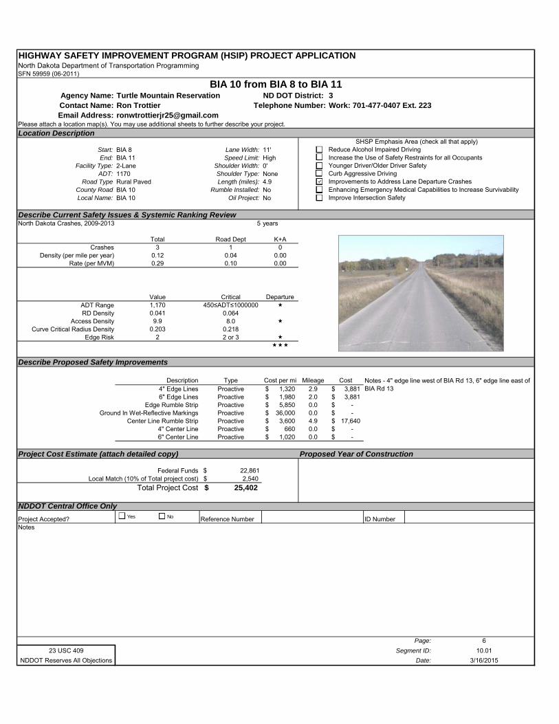
HIGHWAY SAFETY IMPROVEMENT PROGRAM (HSIP) PROJECT APPLICATIONNorth Dakota Department of Transportation ProgrammingSFN 59959 (06-2011)
Agency Name: Turtle Mountain Reservation ND DOT District: 3Contact Name: Ron Trottier Work: 701-477-0407 Ext. 223Email Address: [email protected]
Please attach a location map(s). You may use additional sheets to further describe your project.
Location Description
Start: BIA 8 Lane Width: 11'End: BIA 11 Speed Limit: High
Facility Type: 2-Lane Shoulder Width: 0'ADT: 1170 Shoulder Type: None
Road Type Rural Paved Length (miles): 4.9County Road BIA 10 Rumble Installed: NoLocal Name: BIA 10 Oil Project: No
Describe Current Safety Issues & Systemic Ranking ReviewNorth Dakota Crashes, 2009-2013 5 years
Total Road Dept K+ACrashes 3 1 0
Density (per mile per year) 0.12 0.04 0.00Rate (per MVM) 0.29 0.10 0.00
Value Critical Departure ADT Range 1,170 450≤ADT≤1000000 RD Density 0.041 0.064
Access Density 9.9 8.0 Curve Critical Radius Density 0.203 0.218
Edge Risk 2 2 or 3
Describe Proposed Safety Improvements
Description Type Cost per mi Mileage Cost4" Edge Lines Proactive 1,320$ 2.9 3,881$ 6" Edge Lines Proactive 1,980$ 2.0 3,881$
Edge Rumble Strip Proactive 5,850$ 0.0 -$ Ground In Wet-Reflective Markings Proactive 36,000$ 0.0 -$
Center Line Rumble Strip Proactive 3,600$ 4.9 17,640$ 4" Center Line Proactive 660$ 0.0 -$ 6" Center Line Proactive 1,020$ 0.0 -$
Project Cost Estimate (attach detailed copy) Proposed Year of Construction
Federal Funds $ 22,861 Local Match (10% of Total project cost) 2,540$
Total Project Cost 25,402$
NDDOT Central Office Only
Project Accepted? Reference Number ID NumberNotes
Page: 6
23 USC 409 Segment ID: 10.01
NDDOT Reserves All Objections Date: 3/16/2015
BIA 10 from BIA 8 to BIA 11
Telephone Number:
SHSP Emphasis Area (check all that apply)Reduce Alcohol Impaired DrivingIncrease the Use of Safety Restraints for all OccupantsYounger Driver/Older Driver SafetyCurb Aggressive DrivingImprovements to Address Lane Departure CrashesEnhancing Emergency Medical Capabilities to Increase SurvivabilityImprove Intersection Safety
Notes - 4" edge line west of BIA Rd 13, 6" edge line east of BIA Rd 13
Yes No
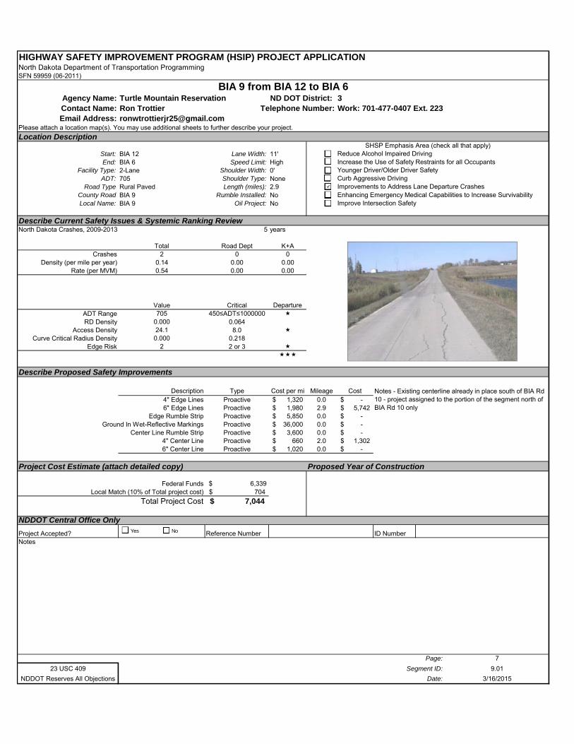
HIGHWAY SAFETY IMPROVEMENT PROGRAM (HSIP) PROJECT APPLICATIONNorth Dakota Department of Transportation ProgrammingSFN 59959 (06-2011)
Agency Name: Turtle Mountain Reservation ND DOT District: 3Contact Name: Ron Trottier Work: 701-477-0407 Ext. 223Email Address: [email protected]
Please attach a location map(s). You may use additional sheets to further describe your project.
Location Description
Start: BIA 12 Lane Width: 11'End: BIA 6 Speed Limit: High
Facility Type: 2-Lane Shoulder Width: 0'ADT: 705 Shoulder Type: None
Road Type Rural Paved Length (miles): 2.9County Road BIA 9 Rumble Installed: NoLocal Name: BIA 9 Oil Project: No
Describe Current Safety Issues & Systemic Ranking ReviewNorth Dakota Crashes, 2009-2013 5 years
Total Road Dept K+ACrashes 2 0 0
Density (per mile per year) 0.14 0.00 0.00Rate (per MVM) 0.54 0.00 0.00
Value Critical Departure ADT Range 705 450≤ADT≤1000000 RD Density 0.000 0.064
Access Density 24.1 8.0 Curve Critical Radius Density 0.000 0.218
Edge Risk 2 2 or 3
Describe Proposed Safety Improvements
Description Type Cost per mi Mileage Cost4" Edge Lines Proactive 1,320$ 0.0 -$ 6" Edge Lines Proactive 1,980$ 2.9 5,742$
Edge Rumble Strip Proactive 5,850$ 0.0 -$ Ground In Wet-Reflective Markings Proactive 36,000$ 0.0 -$
Center Line Rumble Strip Proactive 3,600$ 0.0 -$ 4" Center Line Proactive 660$ 2.0 1,302$ 6" Center Line Proactive 1,020$ 0.0 -$
Project Cost Estimate (attach detailed copy) Proposed Year of Construction
Federal Funds $ 6,339 Local Match (10% of Total project cost) 704$
Total Project Cost 7,044$
NDDOT Central Office Only
Project Accepted? Reference Number ID NumberNotes
Page: 7
23 USC 409 Segment ID: 9.01
NDDOT Reserves All Objections Date: 3/16/2015
BIA 9 from BIA 12 to BIA 6
Telephone Number:
SHSP Emphasis Area (check all that apply)Reduce Alcohol Impaired DrivingIncrease the Use of Safety Restraints for all OccupantsYounger Driver/Older Driver SafetyCurb Aggressive DrivingImprovements to Address Lane Departure CrashesEnhancing Emergency Medical Capabilities to Increase SurvivabilityImprove Intersection Safety
Notes - Existing centerline already in place south of BIA Rd 10 - project assigned to the portion of the segment north of BIA Rd 10 only
Yes No
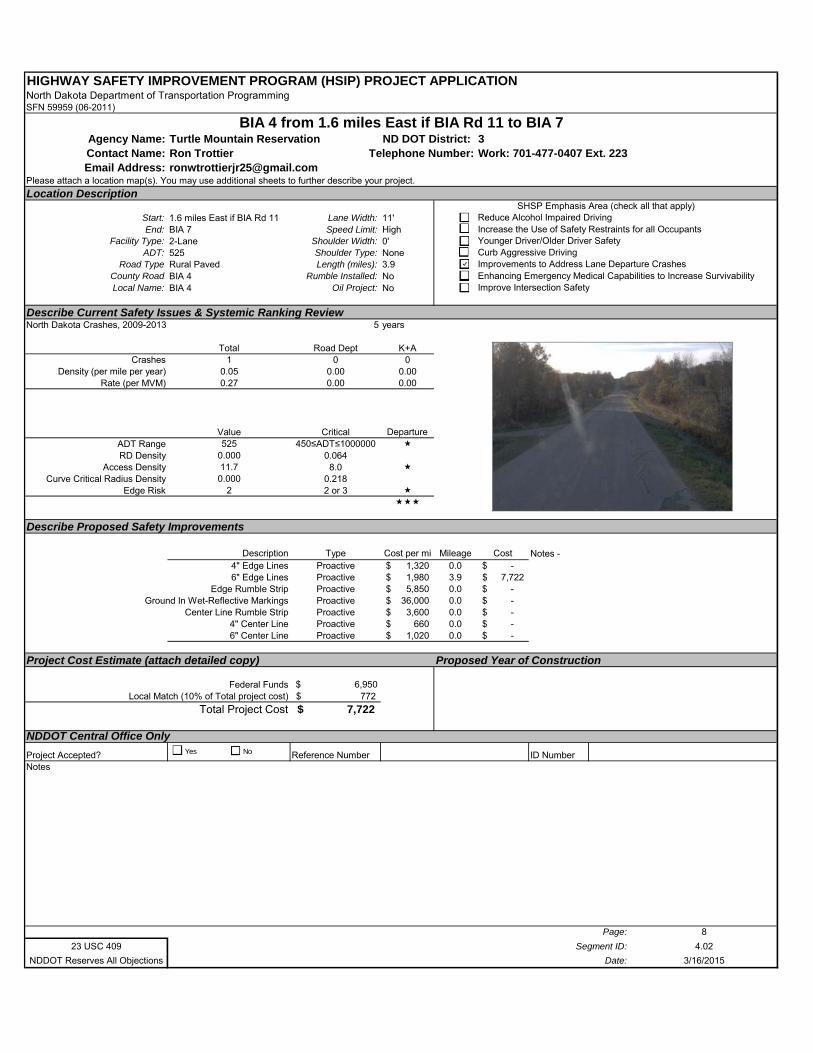
HIGHWAY SAFETY IMPROVEMENT PROGRAM (HSIP) PROJECT APPLICATIONNorth Dakota Department of Transportation ProgrammingSFN 59959 (06-2011)
Agency Name: Turtle Mountain Reservation ND DOT District: 3Contact Name: Ron Trottier Work: 701-477-0407 Ext. 223Email Address: [email protected]
Please attach a location map(s). You may use additional sheets to further describe your project.
Location Description
Start: 1.6 miles East if BIA Rd 11 Lane Width: 11'End: BIA 7 Speed Limit: High
Facility Type: 2-Lane Shoulder Width: 0'ADT: 525 Shoulder Type: None
Road Type Rural Paved Length (miles): 3.9County Road BIA 4 Rumble Installed: NoLocal Name: BIA 4 Oil Project: No
Describe Current Safety Issues & Systemic Ranking ReviewNorth Dakota Crashes, 2009-2013 5 years
Total Road Dept K+ACrashes 1 0 0
Density (per mile per year) 0.05 0.00 0.00Rate (per MVM) 0.27 0.00 0.00
Value Critical Departure ADT Range 525 450≤ADT≤1000000 RD Density 0.000 0.064
Access Density 11.7 8.0 Curve Critical Radius Density 0.000 0.218
Edge Risk 2 2 or 3
Describe Proposed Safety Improvements
Description Type Cost per mi Mileage Cost4" Edge Lines Proactive 1,320$ 0.0 -$ 6" Edge Lines Proactive 1,980$ 3.9 7,722$
Edge Rumble Strip Proactive 5,850$ 0.0 -$ Ground In Wet-Reflective Markings Proactive 36,000$ 0.0 -$
Center Line Rumble Strip Proactive 3,600$ 0.0 -$ 4" Center Line Proactive 660$ 0.0 -$ 6" Center Line Proactive 1,020$ 0.0 -$
Project Cost Estimate (attach detailed copy) Proposed Year of Construction
Federal Funds $ 6,950 Local Match (10% of Total project cost) 772$
Total Project Cost 7,722$
NDDOT Central Office Only
Project Accepted? Reference Number ID NumberNotes
Page: 8
23 USC 409 Segment ID: 4.02
NDDOT Reserves All Objections Date: 3/16/2015
BIA 4 from 1.6 miles East if BIA Rd 11 to BIA 7
Telephone Number:
SHSP Emphasis Area (check all that apply)Reduce Alcohol Impaired DrivingIncrease the Use of Safety Restraints for all OccupantsYounger Driver/Older Driver SafetyCurb Aggressive DrivingImprovements to Address Lane Departure CrashesEnhancing Emergency Medical Capabilities to Increase SurvivabilityImprove Intersection Safety
Notes -
Yes No
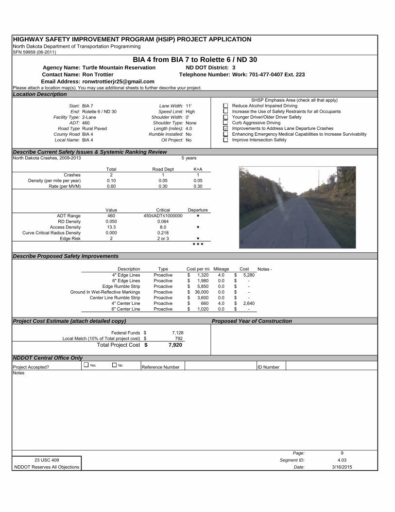
HIGHWAY SAFETY IMPROVEMENT PROGRAM (HSIP) PROJECT APPLICATIONNorth Dakota Department of Transportation ProgrammingSFN 59959 (06-2011)
Agency Name: Turtle Mountain Reservation ND DOT District: 3Contact Name: Ron Trottier Work: 701-477-0407 Ext. 223Email Address: [email protected]
Please attach a location map(s). You may use additional sheets to further describe your project.
Location Description
Start: BIA 7 Lane Width: 11'End: Rolette 6 / ND 30 Speed Limit: High
Facility Type: 2-Lane Shoulder Width: 0'ADT: 460 Shoulder Type: None
Road Type Rural Paved Length (miles): 4.0County Road BIA 4 Rumble Installed: NoLocal Name: BIA 4 Oil Project: No
Describe Current Safety Issues & Systemic Ranking ReviewNorth Dakota Crashes, 2009-2013 5 years
Total Road Dept K+ACrashes 2 1 1
Density (per mile per year) 0.10 0.05 0.05Rate (per MVM) 0.60 0.30 0.30
Value Critical Departure ADT Range 460 450≤ADT≤1000000 RD Density 0.050 0.064
Access Density 13.3 8.0 Curve Critical Radius Density 0.000 0.218
Edge Risk 2 2 or 3
Describe Proposed Safety Improvements
Description Type Cost per mi Mileage Cost4" Edge Lines Proactive 1,320$ 4.0 5,280$ 6" Edge Lines Proactive 1,980$ 0.0 -$
Edge Rumble Strip Proactive 5,850$ 0.0 -$ Ground In Wet-Reflective Markings Proactive 36,000$ 0.0 -$
Center Line Rumble Strip Proactive 3,600$ 0.0 -$ 4" Center Line Proactive 660$ 4.0 2,640$ 6" Center Line Proactive 1,020$ 0.0 -$
Project Cost Estimate (attach detailed copy) Proposed Year of Construction
Federal Funds $ 7,128 Local Match (10% of Total project cost) 792$
Total Project Cost 7,920$
NDDOT Central Office Only
Project Accepted? Reference Number ID NumberNotes
Page: 9
23 USC 409 Segment ID: 4.03
NDDOT Reserves All Objections Date: 3/16/2015
BIA 4 from BIA 7 to Rolette 6 / ND 30
Telephone Number:
SHSP Emphasis Area (check all that apply)Reduce Alcohol Impaired DrivingIncrease the Use of Safety Restraints for all OccupantsYounger Driver/Older Driver SafetyCurb Aggressive DrivingImprovements to Address Lane Departure CrashesEnhancing Emergency Medical Capabilities to Increase SurvivabilityImprove Intersection Safety
Notes -
Yes No
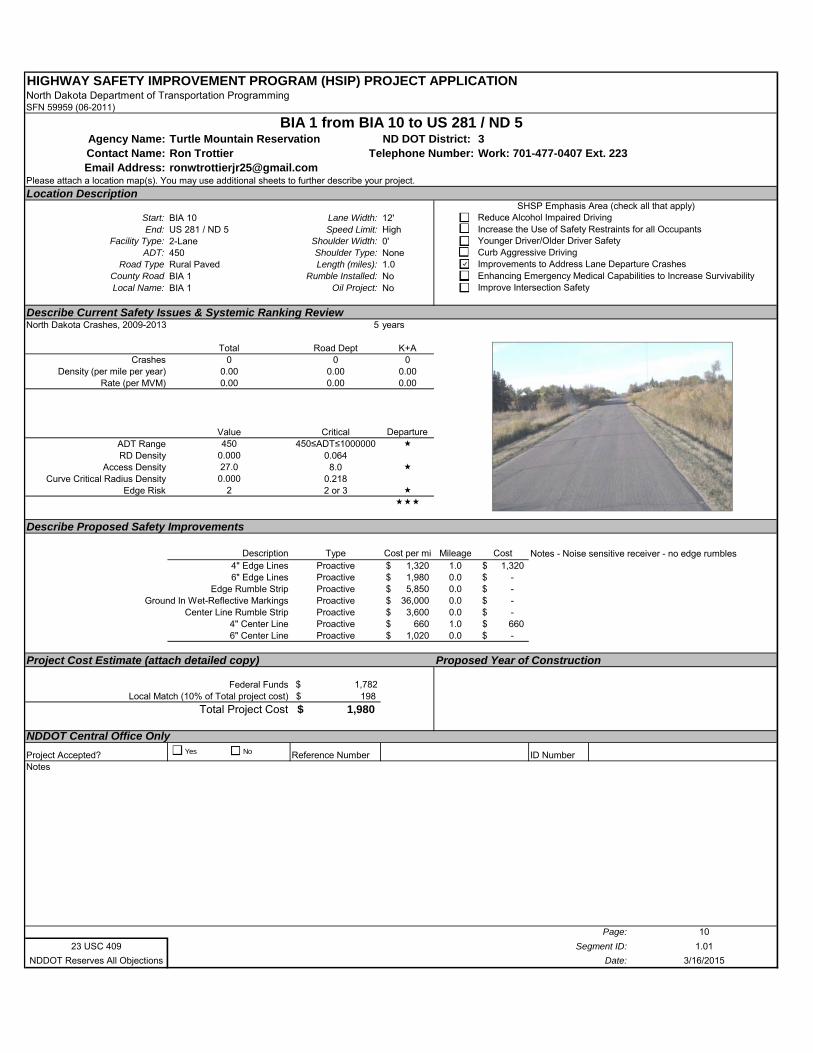
HIGHWAY SAFETY IMPROVEMENT PROGRAM (HSIP) PROJECT APPLICATIONNorth Dakota Department of Transportation ProgrammingSFN 59959 (06-2011)
Agency Name: Turtle Mountain Reservation ND DOT District: 3Contact Name: Ron Trottier Work: 701-477-0407 Ext. 223Email Address: [email protected]
Please attach a location map(s). You may use additional sheets to further describe your project.
Location Description
Start: BIA 10 Lane Width: 12'End: US 281 / ND 5 Speed Limit: High
Facility Type: 2-Lane Shoulder Width: 0'ADT: 450 Shoulder Type: None
Road Type Rural Paved Length (miles): 1.0County Road BIA 1 Rumble Installed: NoLocal Name: BIA 1 Oil Project: No
Describe Current Safety Issues & Systemic Ranking ReviewNorth Dakota Crashes, 2009-2013 5 years
Total Road Dept K+ACrashes 0 0 0
Density (per mile per year) 0.00 0.00 0.00Rate (per MVM) 0.00 0.00 0.00
Value Critical Departure ADT Range 450 450≤ADT≤1000000 RD Density 0.000 0.064
Access Density 27.0 8.0 Curve Critical Radius Density 0.000 0.218
Edge Risk 2 2 or 3
Describe Proposed Safety Improvements
Description Type Cost per mi Mileage Cost4" Edge Lines Proactive 1,320$ 1.0 1,320$ 6" Edge Lines Proactive 1,980$ 0.0 -$
Edge Rumble Strip Proactive 5,850$ 0.0 -$ Ground In Wet-Reflective Markings Proactive 36,000$ 0.0 -$
Center Line Rumble Strip Proactive 3,600$ 0.0 -$ 4" Center Line Proactive 660$ 1.0 660$ 6" Center Line Proactive 1,020$ 0.0 -$
Project Cost Estimate (attach detailed copy) Proposed Year of Construction
Federal Funds $ 1,782 Local Match (10% of Total project cost) 198$
Total Project Cost 1,980$
NDDOT Central Office Only
Project Accepted? Reference Number ID NumberNotes
Page: 10
23 USC 409 Segment ID: 1.01
NDDOT Reserves All Objections Date: 3/16/2015
BIA 1 from BIA 10 to US 281 / ND 5
Telephone Number:
SHSP Emphasis Area (check all that apply)Reduce Alcohol Impaired DrivingIncrease the Use of Safety Restraints for all OccupantsYounger Driver/Older Driver SafetyCurb Aggressive DrivingImprovements to Address Lane Departure CrashesEnhancing Emergency Medical Capabilities to Increase SurvivabilityImprove Intersection Safety
Notes - Noise sensitive receiver - no edge rumbles
Yes No
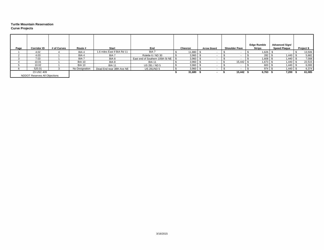
Turtle Mountain ReservationCurve Projects
1 4.02 4 BIA 4 1.6 miles East if BIA Rd 11 BIA 7 11,880$ -$ -$ 1,626$ -$ 13,506$ 2 4.03 1 BIA 4 BIA 7 Rolette 6 / ND 30 3,960$ -$ -$ 282$ 1,440$ 5,682$ 3 7.03 1 BIA 7 BIA 8 East end of Southern 105th St NE 3,960$ -$ -$ 1,608$ 1,440$ 7,008$ 4 10.01 1 BIA 10 BIA 8 BIA 11 3,960$ -$ 15,442$ 1,673$ 1,440$ 22,515$ 5 10.02 1 BIA 10 BIA 11 US 281 / ND 5 3,960$ -$ -$ 600$ 1,440$ 6,000$ 6 520.01 3 No Designation Dead End near 38th Ave NE US 281/ND 5 3,960$ -$ -$ 974$ 1,440$ 6,374$
31,680$ -$ 15,442$ 6,763$ 7,200$ 61,085$
Advanced Sign/ Speed Plaque Project $
23 USC 409NDDOT Reserves All Objections
End Chevron Arrow Board Shoulder PaveEdge Rumble
StripsPage Corridor ID # of Curves Route # Start
3/16/2015
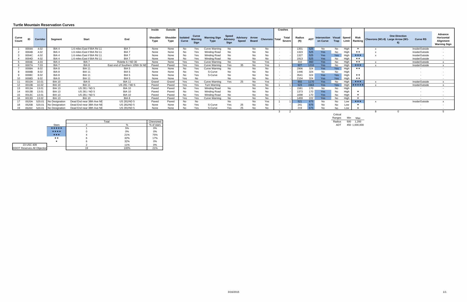
Turtle Mountain Reservation Curves
CurveCount
ID Corridor Segment Start EndShoulder
TypeShoulder
TypeIsolated Curve
Curve Warning
Sign
Warning Sign Type
Speed Advisory
Sign
Advisory Speed
Arrow Board
Chevrons TotalTotal
SevereRadius
(ft)ADT
Intersectionon Curve
VisualTrap
Speed Limit
Risk Ranking
Chevrons (W1-8)One Direction
Large Arrow (W1-6)
Curve RS
Advance Horizontal Alignment
Warning Sign
1 0004A 4.02 BIA 4 1.6 miles East if BIA Rd 11 BIA 7 None None No Yes Curve Warning No No No - - 1301 525 No No High x Inside/Outside -2 0004B 4.02 BIA 4 1.6 miles East if BIA Rd 11 BIA 7 None None No Yes Winding Road No No No - - 1323 525 Yes No High x Inside/Outside -3 0004C 4.02 BIA 4 1.6 miles East if BIA Rd 11 BIA 7 None None No Yes Winding Road No No No - - 1327 525 Yes Yes High x Inside/Outside -4 0004D 4.02 BIA 4 1.6 miles East if BIA Rd 11 BIA 7 None None No Yes Winding Road No No No - - 1913 525 Yes No High Inside/Outside -5 0004E 4.03 BIA 4 BIA 7 Rolette 6 / ND 30 None None Yes Yes Curve Warning No No Yes - - 310 460 Yes No High x Inside/Outside x6 0007A 7.03 BIA 7 BIA 8 East end of Southern 105th St NE Paved Paved Yes Yes Curve Warning Yes 35 No Yes 1 - 927 1210 Yes No High x Inside/Outside x7 0008A 8.02 BIA 8 BIA 11 BIA 5 None None No Yes Curve Warning No No No - - 2906 324 Yes Yes High - -8 0008B 8.02 BIA 8 BIA 11 BIA 5 None None No Yes S-Curve No No No - - 1446 324 No No High - -9 0008C 8.02 BIA 8 BIA 11 BIA 5 None None No Yes S-Curve No No No - - 3541 324 Yes Yes High - -
10 0008D 8.02 BIA 8 BIA 11 BIA 5 None None Yes No No No No - - 2104 324 Yes Yes High - -11 0010A 10.01 BIA 10 BIA 8 BIA 11 Gravel Gravel Yes Yes Curve Warning Yes 25 No Yes - - 955 1170 Yes No High x Inside/Outside x12 0010B 10.02 BIA 10 BIA 11 US 281 / ND 5 Paved Paved Yes Yes Turn Warning No No 1 1 523 1563 Yes Yes High x Inside/Outside x13 0013A 13.01 BIA 13 US 281 / ND 5 BIA 10 Paved Paved No Yes Winding Road No No No - - 1581 170 No No High - -14 0013B 13.01 BIA 13 US 281 / ND 5 BIA 10 Paved Paved No Yes Winding Road No No No - - 1373 170 Yes No High - -15 0013C 13.01 BIA 13 US 281 / ND 5 BIA 10 Paved Paved No Yes Winding Road No No No - - 1698 170 Yes No High - -16 0013D 13.02 BIA 13 BIA 10 BIA 6 Paved Paved Yes Yes Curve Warning No No No - - 1459 222 Yes No High - -17 0520A 520.01 No Designation Dead End near 38th Ave NE US 281/ND 5 Paved Paved No No No No Yes 1 1 521 675 No No Low x Inside/Outside x18 0520B 520.01 No Designation Dead End near 38th Ave NE US 281/ND 5 None None No Yes S-Curve Yes 25 No No - - 241 675 No No Low - -19 0520C 520.01 No Designation Dead End near 38th Ave NE US 281/ND 5 None None No Yes S-Curve Yes 25 No No - - 219 675 No No Low - -
3 2 4 11 5 8 0 5Critical
Ranges Min MaxTotal (ft) Radius 500 1,200
Stars # % % of stars Total (mi) ADT 450 1,000,000 1 5% 0% Average (ft) 0 0% 0% 4 21% 75% 6 32% 17% 6 32% 0%
2 11% 0%19 100% 21%
23 USC 409NDDOT Reserves All Objection
Total Chevroned
Inside Outside Crashes
3/16/2015 1/1
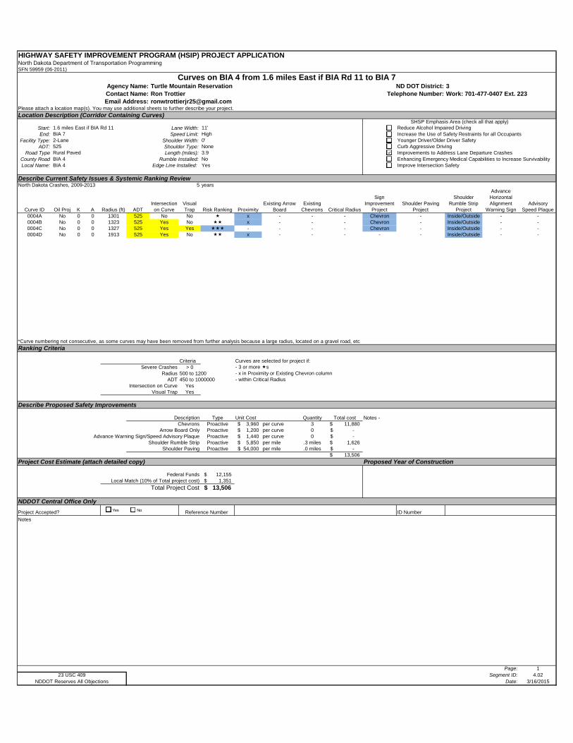
HIGHWAY SAFETY IMPROVEMENT PROGRAM (HSIP) PROJECT APPLICATIONNorth Dakota Department of Transportation ProgrammingSFN 59959 (06-2011)
Turtle Mountain Reservation 3Ron Trottier Work: 701-477-0407 Ext. [email protected]
Please attach a location map(s). You may use additional sheets to further describe your project.
Location Description (Corridor Containing Curves)
Start: Lane Width:End: Speed Limit:
Facility Type: Shoulder Width:ADT: Shoulder Type:
Road Type Length (miles):County Road Rumble Installed:Local Name: Edge Line Installed:
Describe Current Safety Issues & Systemic Ranking ReviewNorth Dakota Crashes, 2009-2013 5 years
Curve ID Oil Proj K A Radius (ft) ADTIntersection
on CurveVisual Trap Risk Ranking Proximity
Existing Arrow Board
Existing Chevrons Critical Radius
Sign Improvement
ProjectShoulder Paving
Project
Shoulder Rumble Strip
Project
Advance Horizontal Alignment
Warning SignAdvisory
Speed Plaque0004A No 0 0 1301 525 No No x - - - Chevron - Inside/Outside - -0004B No 0 0 1323 525 Yes No x - - - Chevron - Inside/Outside - -0004C No 0 0 1327 525 Yes Yes - - - - Chevron - Inside/Outside - -0004D No 0 0 1913 525 Yes No x - - - - - Inside/Outside - -
*Curve numbering not consecutive, as some curves may have been removed from further analysis because a large radius, located on a gravel road, etc
Ranking Criteria
Criteria Curves are selected for project if:Severe Crashes > 0 - 3 or more s
Radius 500 to 1200 - x in Proximity or Existing Chevron columnADT 450 to 1000000 - within Critical Radius
Intersection on Curve YesVisual Trap Yes
Describe Proposed Safety Improvements
Description Type Unit Cost Quantity Total costChevrons Proactive 3,960$ per curve 3 11,880$
Arrow Board Only Proactive 1,200$ per curve 0 -$ Advance Warning Sign/Speed Advisory Plaque Proactive 1,440$ per curve 0 -$
Shoulder Rumble Strip Proactive 5,850$ per mile .3 miles 1,626$ Shoulder Paving Proactive 54,000$ per mile .0 miles -$
13,506$
Project Cost Estimate (attach detailed copy) Proposed Year of Construction
Federal Funds 12,155$ Local Match (10% of Total project cost) 1,351$
Total Project Cost 13,506$
NDDOT Central Office Only
ID Number
Notes
Page: 1Segment ID: 4.02
Date: 3/16/2015
BIA 71.6 miles East if BIA Rd 11
Email Address:
Curves on BIA 4 from 1.6 miles East if BIA Rd 11 to BIA 7Agency Name: ND DOT District:Contact Name: Telephone Number:
SHSP Emphasis Area (check all that apply)Reduce Alcohol Impaired DrivingIncrease the Use of Safety Restraints for all Occupants
11'High
Younger Driver/Older Driver SafetyCurb Aggressive DrivingNone
0'5252-Lane
Improvements to Address Lane Departure CrashesEnhancing Emergency Medical Capabilities to Increase SurvivabilityNo
3.9BIA 4Rural Paved
NDDOT Reserves All Objections23 USC 409
Improve Intersection Safety
Project Accepted? Reference Number
Notes -
YesBIA 4
Yes No
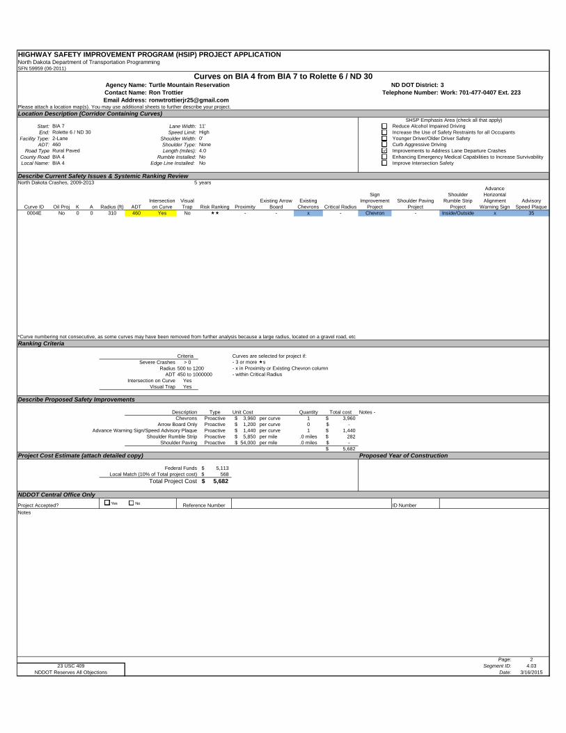
HIGHWAY SAFETY IMPROVEMENT PROGRAM (HSIP) PROJECT APPLICATIONNorth Dakota Department of Transportation ProgrammingSFN 59959 (06-2011)
Turtle Mountain Reservation 3Ron Trottier Work: 701-477-0407 Ext. [email protected]
Please attach a location map(s). You may use additional sheets to further describe your project.
Location Description (Corridor Containing Curves)
Start: Lane Width:End: Speed Limit:
Facility Type: Shoulder Width:ADT: Shoulder Type:
Road Type Length (miles):County Road Rumble Installed:Local Name: Edge Line Installed:
Describe Current Safety Issues & Systemic Ranking ReviewNorth Dakota Crashes, 2009-2013 5 years
Curve ID Oil Proj K A Radius (ft) ADTIntersection
on CurveVisual Trap Risk Ranking Proximity
Existing Arrow Board
Existing Chevrons Critical Radius
Sign Improvement
ProjectShoulder Paving
Project
Shoulder Rumble Strip
Project
Advance Horizontal Alignment
Warning SignAdvisory
Speed Plaque0004E No 0 0 310 460 Yes No - - x - Chevron - Inside/Outside x 35
*Curve numbering not consecutive, as some curves may have been removed from further analysis because a large radius, located on a gravel road, etc
Ranking Criteria
Criteria Curves are selected for project if:Severe Crashes > 0 - 3 or more s
Radius 500 to 1200 - x in Proximity or Existing Chevron columnADT 450 to 1000000 - within Critical Radius
Intersection on Curve YesVisual Trap Yes
Describe Proposed Safety Improvements
Description Type Unit Cost Quantity Total costChevrons Proactive 3,960$ per curve 1 3,960$
Arrow Board Only Proactive 1,200$ per curve 0 -$ Advance Warning Sign/Speed Advisory Plaque Proactive 1,440$ per curve 1 1,440$
Shoulder Rumble Strip Proactive 5,850$ per mile .0 miles 282$ Shoulder Paving Proactive 54,000$ per mile .0 miles -$
5,682$
Project Cost Estimate (attach detailed copy) Proposed Year of Construction
Federal Funds 5,113$ Local Match (10% of Total project cost) 568$
Total Project Cost 5,682$
NDDOT Central Office Only
ID Number
Notes
Page: 2Segment ID: 4.03
Date: 3/16/2015
Rolette 6 / ND 30BIA 7
Email Address:
Curves on BIA 4 from BIA 7 to Rolette 6 / ND 30Agency Name: ND DOT District:Contact Name: Telephone Number:
SHSP Emphasis Area (check all that apply)Reduce Alcohol Impaired DrivingIncrease the Use of Safety Restraints for all Occupants
11'High
Younger Driver/Older Driver SafetyCurb Aggressive DrivingNone
0'4602-Lane
Improvements to Address Lane Departure CrashesEnhancing Emergency Medical Capabilities to Increase SurvivabilityNo
4.0BIA 4Rural Paved
NDDOT Reserves All Objections23 USC 409
Improve Intersection Safety
Project Accepted? Reference Number
Notes -
NoBIA 4
Yes No
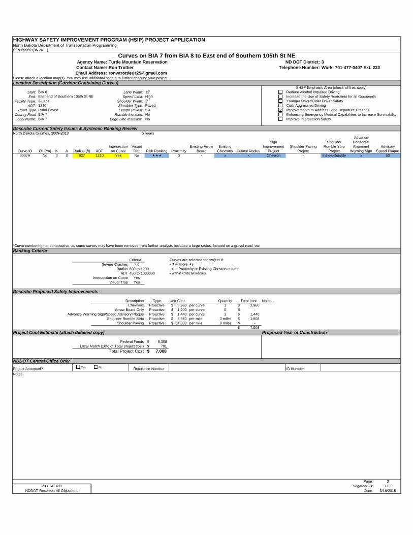
HIGHWAY SAFETY IMPROVEMENT PROGRAM (HSIP) PROJECT APPLICATIONNorth Dakota Department of Transportation ProgrammingSFN 59959 (06-2011)
Turtle Mountain Reservation 3Ron Trottier Work: 701-477-0407 Ext. [email protected]
Please attach a location map(s). You may use additional sheets to further describe your project.
Location Description (Corridor Containing Curves)
Start: Lane Width:End: Speed Limit:
Facility Type: Shoulder Width:ADT: Shoulder Type:
Road Type Length (miles):County Road Rumble Installed:Local Name: Edge Line Installed:
Describe Current Safety Issues & Systemic Ranking ReviewNorth Dakota Crashes, 2009-2013 5 years
Curve ID Oil Proj K A Radius (ft) ADTIntersection
on CurveVisual Trap Risk Ranking Proximity
Existing Arrow Board
Existing Chevrons Critical Radius
Sign Improvement
ProjectShoulder Paving
Project
Shoulder Rumble Strip
Project
Advance Horizontal Alignment
Warning SignAdvisory
Speed Plaque0007A No 0 0 927 1210 Yes No 0 - x x Chevron - Inside/Outside x 50
*Curve numbering not consecutive, as some curves may have been removed from further analysis because a large radius, located on a gravel road, etc
Ranking Criteria
Criteria Curves are selected for project if:Severe Crashes > 0 - 3 or more s
Radius 500 to 1200 - x in Proximity or Existing Chevron columnADT 450 to 1000000 - within Critical Radius
Intersection on Curve YesVisual Trap Yes
Describe Proposed Safety Improvements
Description Type Unit Cost Quantity Total costChevrons Proactive 3,960$ per curve 1 3,960$
Arrow Board Only Proactive 1,200$ per curve 0 -$ Advance Warning Sign/Speed Advisory Plaque Proactive 1,440$ per curve 1 1,440$
Shoulder Rumble Strip Proactive 5,850$ per mile .3 miles 1,608$ Shoulder Paving Proactive 54,000$ per mile .0 miles -$
7,008$
Project Cost Estimate (attach detailed copy) Proposed Year of Construction
Federal Funds 6,308$ Local Match (10% of Total project cost) 701$
Total Project Cost 7,008$
NDDOT Central Office Only
ID Number
Notes
Page: 3Segment ID: 7.03
Date: 3/16/2015
East end of Southern 105th St NEBIA 8
Email Address:
Curves on BIA 7 from BIA 8 to East end of Southern 105th St NEAgency Name: ND DOT District:Contact Name: Telephone Number:
SHSP Emphasis Area (check all that apply)Reduce Alcohol Impaired DrivingIncrease the Use of Safety Restraints for all Occupants
12'High
Younger Driver/Older Driver SafetyCurb Aggressive DrivingPaved
2'12102-Lane
Improvements to Address Lane Departure CrashesEnhancing Emergency Medical Capabilities to Increase SurvivabilityNo
5.4BIA 7Rural Paved
NDDOT Reserves All Objections23 USC 409
Improve Intersection Safety
Project Accepted? Reference Number
Notes -
NoBIA 7
Yes No
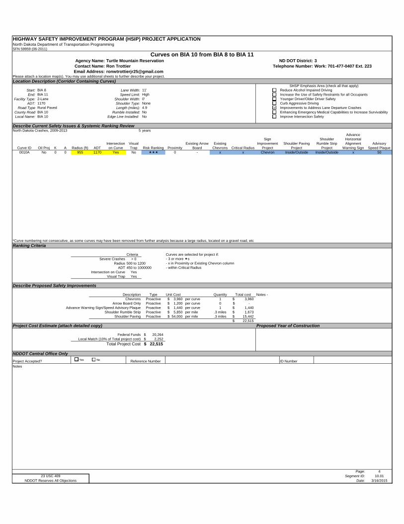
HIGHWAY SAFETY IMPROVEMENT PROGRAM (HSIP) PROJECT APPLICATIONNorth Dakota Department of Transportation ProgrammingSFN 59959 (06-2011)
Turtle Mountain Reservation 3Ron Trottier Work: 701-477-0407 Ext. [email protected]
Please attach a location map(s). You may use additional sheets to further describe your project.
Location Description (Corridor Containing Curves)
Start: Lane Width:End: Speed Limit:
Facility Type: Shoulder Width:ADT: Shoulder Type:
Road Type Length (miles):County Road Rumble Installed:Local Name: Edge Line Installed:
Describe Current Safety Issues & Systemic Ranking ReviewNorth Dakota Crashes, 2009-2013 5 years
Curve ID Oil Proj K A Radius (ft) ADTIntersection
on CurveVisual Trap Risk Ranking Proximity
Existing Arrow Board
Existing Chevrons Critical Radius
Sign Improvement
ProjectShoulder Paving
Project
Shoulder Rumble Strip
Project
Advance Horizontal Alignment
Warning SignAdvisory
Speed Plaque0010A No 0 0 955 1170 Yes No 0 - x x Chevron Inside/Outside Inside/Outside x 50
*Curve numbering not consecutive, as some curves may have been removed from further analysis because a large radius, located on a gravel road, etc
Ranking Criteria
Criteria Curves are selected for project if:Severe Crashes > 0 - 3 or more s
Radius 500 to 1200 - x in Proximity or Existing Chevron columnADT 450 to 1000000 - within Critical Radius
Intersection on Curve YesVisual Trap Yes
Describe Proposed Safety Improvements
Description Type Unit Cost Quantity Total costChevrons Proactive 3,960$ per curve 1 3,960$
Arrow Board Only Proactive 1,200$ per curve 0 -$ Advance Warning Sign/Speed Advisory Plaque Proactive 1,440$ per curve 1 1,440$
Shoulder Rumble Strip Proactive 5,850$ per mile .3 miles 1,673$ Shoulder Paving Proactive 54,000$ per mile .3 miles 15,442$
22,515$
Project Cost Estimate (attach detailed copy) Proposed Year of Construction
Federal Funds 20,264$ Local Match (10% of Total project cost) 2,252$
Total Project Cost 22,515$
NDDOT Central Office Only
ID Number
Notes
Page: 4Segment ID: 10.01
Date: 3/16/2015
BIA 11BIA 8
Email Address:
Curves on BIA 10 from BIA 8 to BIA 11Agency Name: ND DOT District:Contact Name: Telephone Number:
SHSP Emphasis Area (check all that apply)Reduce Alcohol Impaired DrivingIncrease the Use of Safety Restraints for all Occupants
11'High
Younger Driver/Older Driver SafetyCurb Aggressive DrivingNone
0'11702-Lane
Improvements to Address Lane Departure CrashesEnhancing Emergency Medical Capabilities to Increase SurvivabilityNo
4.9BIA 10Rural Paved
NDDOT Reserves All Objections23 USC 409
Improve Intersection Safety
Project Accepted? Reference Number
Notes -
NoBIA 10
Yes No
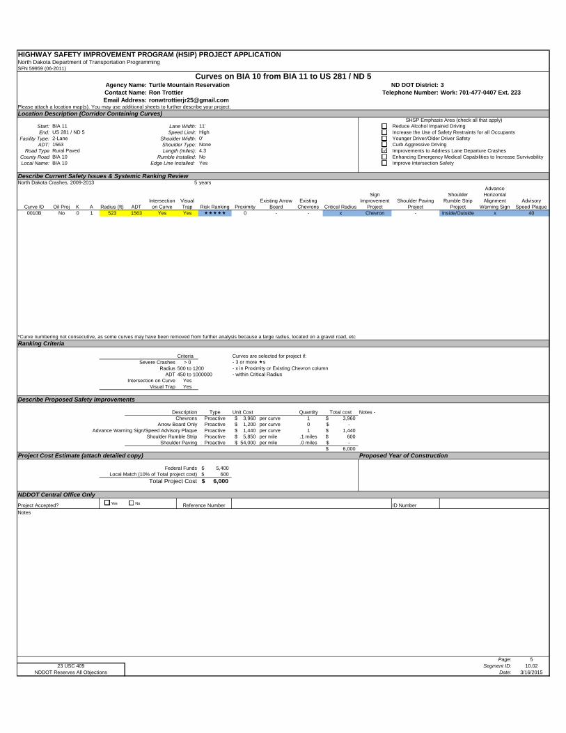
HIGHWAY SAFETY IMPROVEMENT PROGRAM (HSIP) PROJECT APPLICATIONNorth Dakota Department of Transportation ProgrammingSFN 59959 (06-2011)
Turtle Mountain Reservation 3Ron Trottier Work: 701-477-0407 Ext. [email protected]
Please attach a location map(s). You may use additional sheets to further describe your project.
Location Description (Corridor Containing Curves)
Start: Lane Width:End: Speed Limit:
Facility Type: Shoulder Width:ADT: Shoulder Type:
Road Type Length (miles):County Road Rumble Installed:Local Name: Edge Line Installed:
Describe Current Safety Issues & Systemic Ranking ReviewNorth Dakota Crashes, 2009-2013 5 years
Curve ID Oil Proj K A Radius (ft) ADTIntersection
on CurveVisual Trap Risk Ranking Proximity
Existing Arrow Board
Existing Chevrons Critical Radius
Sign Improvement
ProjectShoulder Paving
Project
Shoulder Rumble Strip
Project
Advance Horizontal Alignment
Warning SignAdvisory
Speed Plaque0010B No 0 1 523 1563 Yes Yes 0 - - x Chevron - Inside/Outside x 40
*Curve numbering not consecutive, as some curves may have been removed from further analysis because a large radius, located on a gravel road, etc
Ranking Criteria
Criteria Curves are selected for project if:Severe Crashes > 0 - 3 or more s
Radius 500 to 1200 - x in Proximity or Existing Chevron columnADT 450 to 1000000 - within Critical Radius
Intersection on Curve YesVisual Trap Yes
Describe Proposed Safety Improvements
Description Type Unit Cost Quantity Total costChevrons Proactive 3,960$ per curve 1 3,960$
Arrow Board Only Proactive 1,200$ per curve 0 -$ Advance Warning Sign/Speed Advisory Plaque Proactive 1,440$ per curve 1 1,440$
Shoulder Rumble Strip Proactive 5,850$ per mile .1 miles 600$ Shoulder Paving Proactive 54,000$ per mile .0 miles -$
6,000$
Project Cost Estimate (attach detailed copy) Proposed Year of Construction
Federal Funds 5,400$ Local Match (10% of Total project cost) 600$
Total Project Cost 6,000$
NDDOT Central Office Only
ID Number
Notes
Page: 5Segment ID: 10.02
Date: 3/16/2015
US 281 / ND 5BIA 11
Email Address:
Curves on BIA 10 from BIA 11 to US 281 / ND 5Agency Name: ND DOT District:Contact Name: Telephone Number:
SHSP Emphasis Area (check all that apply)Reduce Alcohol Impaired DrivingIncrease the Use of Safety Restraints for all Occupants
11'High
Younger Driver/Older Driver SafetyCurb Aggressive DrivingNone
0'15632-Lane
Improvements to Address Lane Departure CrashesEnhancing Emergency Medical Capabilities to Increase SurvivabilityNo
4.3BIA 10Rural Paved
NDDOT Reserves All Objections23 USC 409
Improve Intersection Safety
Project Accepted? Reference Number
Notes -
YesBIA 10
Yes No
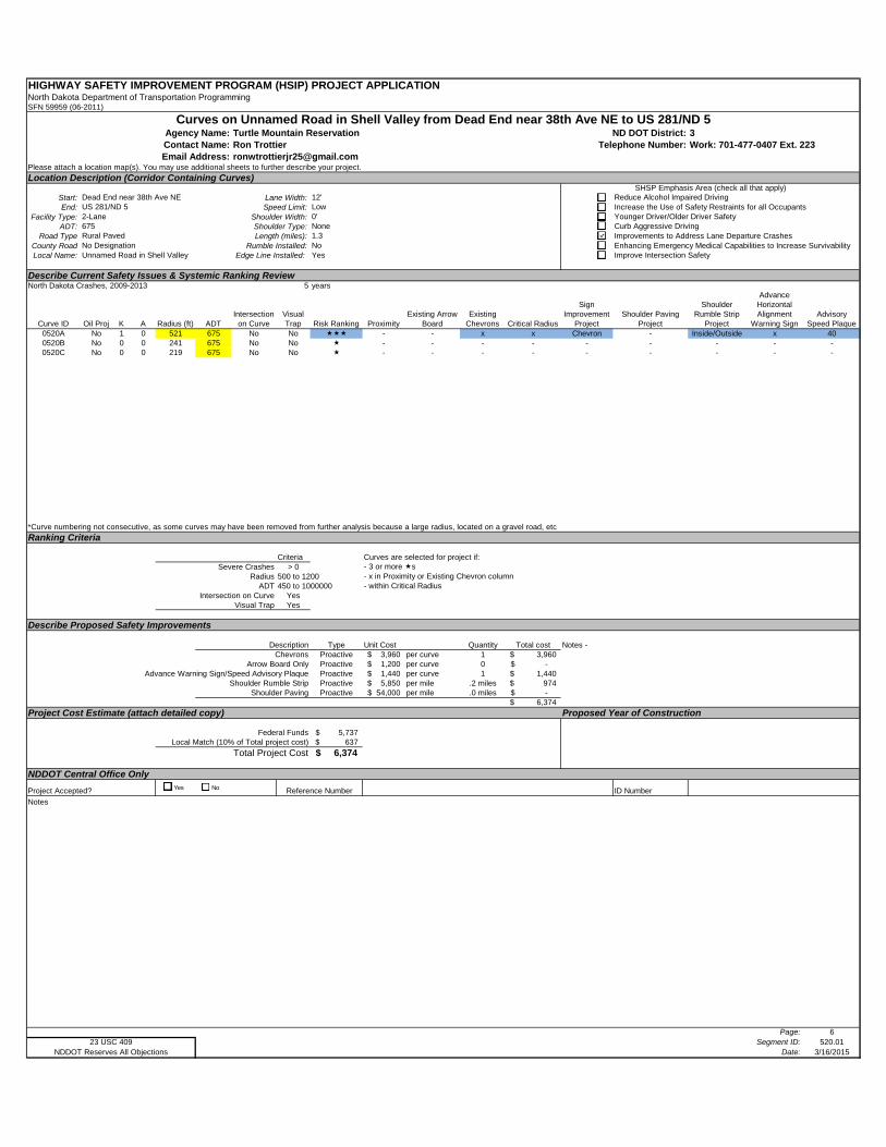
HIGHWAY SAFETY IMPROVEMENT PROGRAM (HSIP) PROJECT APPLICATIONNorth Dakota Department of Transportation ProgrammingSFN 59959 (06-2011)
Turtle Mountain Reservation 3Ron Trottier Work: 701-477-0407 Ext. [email protected]
Please attach a location map(s). You may use additional sheets to further describe your project.
Location Description (Corridor Containing Curves)
Start: Lane Width:End: Speed Limit:
Facility Type: Shoulder Width:ADT: Shoulder Type:
Road Type Length (miles):County Road Rumble Installed:Local Name: Edge Line Installed:
Describe Current Safety Issues & Systemic Ranking ReviewNorth Dakota Crashes, 2009-2013 5 years
Curve ID Oil Proj K A Radius (ft) ADTIntersection
on CurveVisual Trap Risk Ranking Proximity
Existing Arrow Board
Existing Chevrons Critical Radius
Sign Improvement
ProjectShoulder Paving
Project
Shoulder Rumble Strip
Project
Advance Horizontal Alignment
Warning SignAdvisory
Speed Plaque0520A No 1 0 521 675 No No - - x x Chevron - Inside/Outside x 400520B No 0 0 241 675 No No - - - - - - - - -0520C No 0 0 219 675 No No - - - - - - - - -
*Curve numbering not consecutive, as some curves may have been removed from further analysis because a large radius, located on a gravel road, etc
Ranking Criteria
Criteria Curves are selected for project if:Severe Crashes > 0 - 3 or more s
Radius 500 to 1200 - x in Proximity or Existing Chevron columnADT 450 to 1000000 - within Critical Radius
Intersection on Curve YesVisual Trap Yes
Describe Proposed Safety Improvements
Description Type Unit Cost Quantity Total costChevrons Proactive 3,960$ per curve 1 3,960$
Arrow Board Only Proactive 1,200$ per curve 0 -$ Advance Warning Sign/Speed Advisory Plaque Proactive 1,440$ per curve 1 1,440$
Shoulder Rumble Strip Proactive 5,850$ per mile .2 miles 974$ Shoulder Paving Proactive 54,000$ per mile .0 miles -$
6,374$
Project Cost Estimate (attach detailed copy) Proposed Year of Construction
Federal Funds 5,737$ Local Match (10% of Total project cost) 637$
Total Project Cost 6,374$
NDDOT Central Office Only
ID Number
Notes
Page: 6Segment ID: 520.01
Date: 3/16/2015
US 281/ND 5Dead End near 38th Ave NE
Email Address:
Curves on Unnamed Road in Shell Valley from Dead End near 38th Ave NE to US 281/ND 5Agency Name: ND DOT District:Contact Name: Telephone Number:
SHSP Emphasis Area (check all that apply)Reduce Alcohol Impaired DrivingIncrease the Use of Safety Restraints for all Occupants
12'Low
Younger Driver/Older Driver SafetyCurb Aggressive DrivingNone
0'6752-Lane
Improvements to Address Lane Departure CrashesEnhancing Emergency Medical Capabilities to Increase SurvivabilityNo
1.3No DesignationRural Paved
NDDOT Reserves All Objections23 USC 409
Improve Intersection Safety
Project Accepted? Reference Number
Notes -
YesUnnamed Road in Shell Valley
Yes No
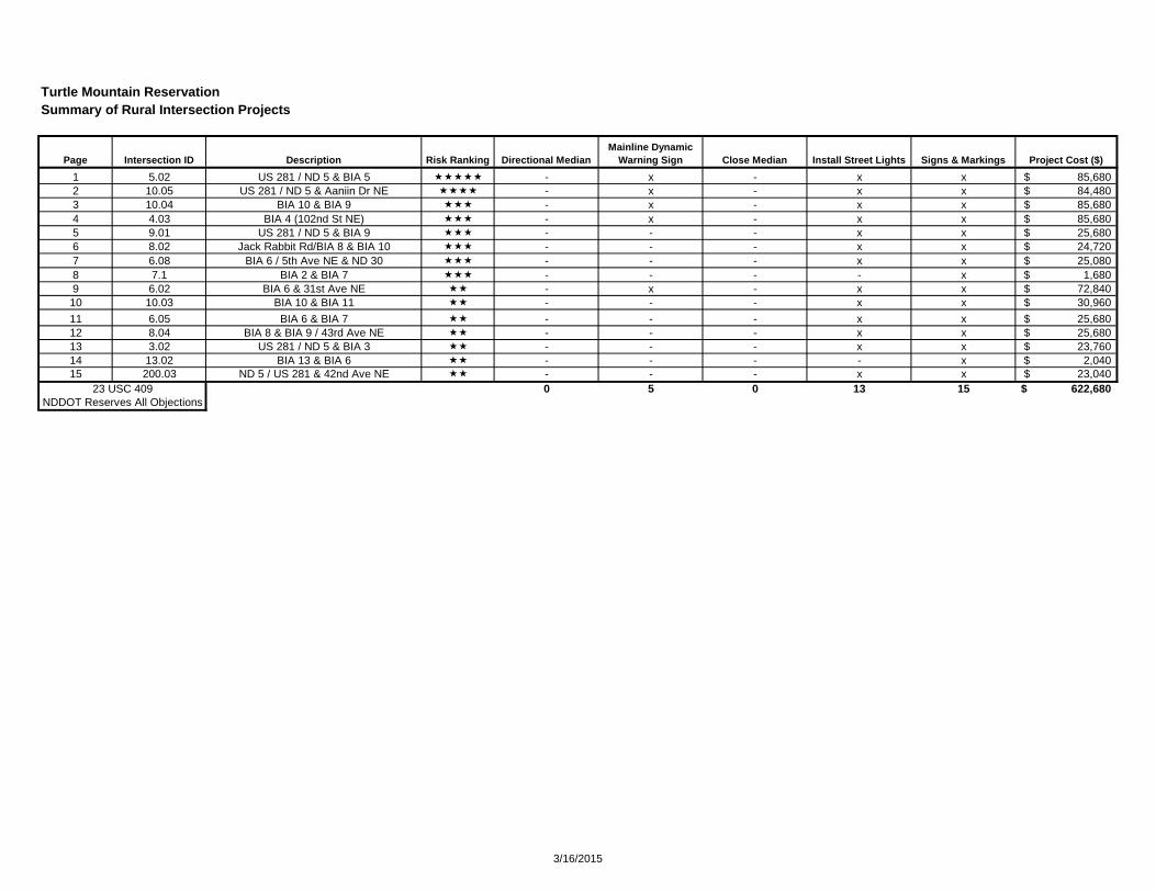
Turtle Mountain ReservationSummary of Rural Intersection Projects
1 5.02 US 281 / ND 5 & BIA 5 - x - x x 85,680$ 2 10.05 US 281 / ND 5 & Aaniin Dr NE - x - x x 84,480$ 3 10.04 BIA 10 & BIA 9 - x - x x 85,680$ 4 4.03 BIA 4 (102nd St NE) - x - x x 85,680$ 5 9.01 US 281 / ND 5 & BIA 9 - - - x x 25,680$ 6 8.02 Jack Rabbit Rd/BIA 8 & BIA 10 - - - x x 24,720$ 7 6.08 BIA 6 / 5th Ave NE & ND 30 - - - x x 25,080$ 8 7.1 BIA 2 & BIA 7 - - - - x 1,680$ 9 6.02 BIA 6 & 31st Ave NE - x - x x 72,840$ 10 10.03 BIA 10 & BIA 11 - - - x x 30,960$
11 6.05 BIA 6 & BIA 7 - - - x x 25,680$ 12 8.04 BIA 8 & BIA 9 / 43rd Ave NE - - - x x 25,680$ 13 3.02 US 281 / ND 5 & BIA 3 - - - x x 23,760$ 14 13.02 BIA 13 & BIA 6 - - - - x 2,040$ 15 200.03 ND 5 / US 281 & 42nd Ave NE - - - x x 23,040$
0 5 0 13 15 622,680$
Install Street LightsDescriptionPage Intersection ID Project Cost ($)Signs & MarkingsClose MedianRisk Ranking Directional MedianMainline Dynamic
Warning Sign
23 USC 409NDDOT Reserves All Objections
3/16/2015
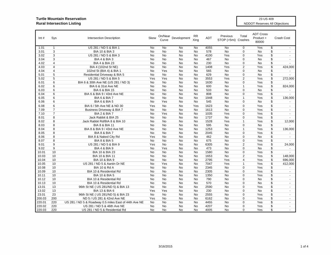
Turtle Mountain ReservationRural Intersection Listing
Int # Sys Intersection Description SkewOn/NearCurve
DevelopmentRR Xing
ADTPrevious
STOP (>5mi)Total
Crashes
ADT Cross Product >
80000Crash Cost
1.01 1 US 281 / ND 5 & BIA 1 No No No No 4055 No 0 Yes -$ 3.01 3 BIA 10 & BIA 3 No No No No 578 No 0 No -$ 3.02 3 US 281 / ND 5 & BIA 3 No No No No 4100 Yes 0 Yes -$ 3.04 3 BIA 4 & BIA 3 No No No No 467 No 0 No -$ 4.02 4 BIA 4 & BIA 23 No No No No 230 No 0 No -$ 4.03 4 BIA 4 (102nd St NE) No No No No 1408 Yes 2 Yes 424,000$ 4.04 4 102nd St (BIA 4) & BIA 1 No Yes No No 565 No 0 No -$ 5.01 5 Residential Driveway & BIA 5 No No No No 629 No 0 No -$ 5.02 5 US 281 / ND 5 & BIA 5 Yes Yes No No 3553 Yes 2 Yes 272,000$ 6.01 6 BIA 6 & 30th Ave NE (US 281 / ND 3) No No No No 1630 No 0 Yes -$ 6.02 6 BIA 6 & 31st Ave NE No No No No 600 No 1 Yes 824,000$ 6.03 6 BIA 6 & BIA 15 No No No No 533 No 0 No -$ 6.04 6 BIA 6 & BIA 9 / 43rd Ave NE No No No No 808 No 0 Yes -$ 6.05 6 BIA 6 & BIA 7 No No No No 1948 No 1 Yes 136,000$ 6.06 6 BIA 6 & BIA 5 No Yes No No 545 No 0 No -$
6.08 6 BIA 6 / 5th Ave NE & ND 30 Yes No No Yes 1623 No 0 Yes -$ 7.09 7 Business Driveway & BIA 7 No No No No 1613 No 0 Yes -$ 7.10 7 BIA 2 & BIA 7 No Yes No No 1035 Yes 0 Yes -$ 8.01 8 Jack Rabbit & BIA 25 No No No No 1737 No 0 Yes -$ 8.02 8 Jack Rabbit Rd/BIA 8 & BIA 10 No No No No 1528 Yes 1 Yes 12,000$ 8.03 8 BIA 8 & BIA 11 No No No No 595 No 0 No -$ 8.04 8 BIA 8 & BIA 9 / 43rd Ave NE No No No No 1253 No 1 Yes 136,000$ 8.05 8 BIA 8 & BIA 7 No No No No 2045 No 0 Yes -$ 8.06 8 BIA 8 & Naked City Rd Yes No No No 462 No 0 No -$ 8.07 8 BIA 8 & BIA 5 No No No No 675 No 0 Yes -$ 9.01 9 US 281 / ND 5 & BIA 9 Yes No No No 6305 No 2 Yes 24,000$ 9.02 9 BIA 4 & BIA 9 No Yes No No 473 No 0 No -$ 10.01 10 BIA 10 & BIA 23 No No No No 1580 No 0 Yes -$ 10.03 10 BIA 10 & BIA 11 No No No No 1653 No 2 Yes 148,000$ 10.04 10 BIA 10 & BIA 9 No No No No 2795 Yes 4 Yes 696,000$ 10.05 10 US 281 / ND 5 & Aaniin Dr NE No Yes No No 7047 Yes 1 Yes 412,000$ 10.08 10 BIA 10 & Rd A No No No No 2345 No 0 Yes -$ 10.09 10 BIA 10 & Residential Rd No No No No 2305 No 0 Yes -$ 10.11 10 BIA 10 & BIA 5 No No No No 1350 No 0 Yes -$ 10.12 10 BIA 10 & Residential Rd No No No No 790 No 0 No -$ 10.13 10 BIA 10 & Residential Rd No No No No 570 No 0 No -$ 13.01 13 96th St NE ( US 281/ND 5) & BIA 13 No No No No 2590 No 0 Yes -$ 13.02 13 BIA 13 & BIA 6 Yes Yes No No 230 No 0 No -$ 23.01 23 96th St NE ( US 281/ND 5) & BIA 23 No No No No 2555 No 0 Yes -$ 200.03 200 ND 5 / US 281 & 42nd Ave NE Yes No No No 6162 No 0 Yes -$ 220.01 220 US 281 / ND 5 & Roadway 0.5 miles East of 44th Ave NE No No No No 4455 No 0 Yes -$ 220.02 220 US 281 / ND 5 & 46th Ave NE No No No No 4207 No 0 Yes -$ 220.03 220 US 281 / ND 5 & Residential Rd No No No No 4005 No 0 Yes -$
23 US 409
NDDOT Reserves All Objections
3/16/2015 1 of 4
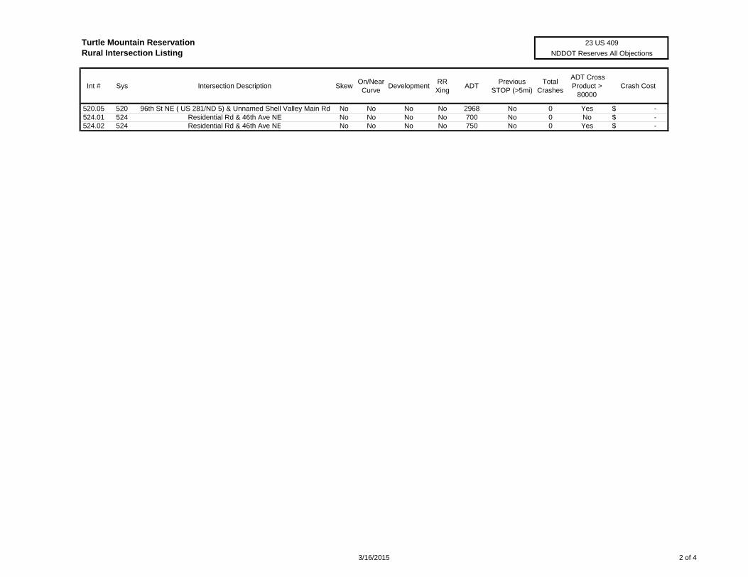
Turtle Mountain ReservationRural Intersection Listing
Int # Sys Intersection Description SkewOn/NearCurve
DevelopmentRR Xing
ADTPrevious
STOP (>5mi)Total
Crashes
ADT Cross Product >
80000Crash Cost
23 US 409
NDDOT Reserves All Objections
520.05 520 96th St NE ( US 281/ND 5) & Unnamed Shell Valley Main Rd No No No No 2968 No 0 Yes -$ 524.01 524 Residential Rd & 46th Ave NE No No No No 700 No 0 No -$ 524.02 524 Residential Rd & 46th Ave NE No No No No 750 No 0 Yes -$
3/16/2015 2 of 4
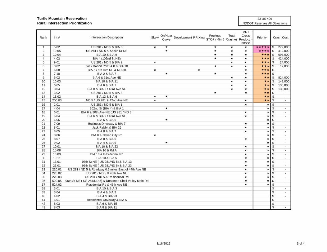
Turtle Mountain ReservationRural Intersection Prioritization
Rank Int # SkewOn/NearCurve
Development RR XingPrevious
STOP (>5mi)Total
Crashes
ADT Cross
Product > 80000
Priority Crash Cost
1 5.02 272,000$ 2 10.05 412,000$ 3 10.04 696,000$ 4 4.03 424,000$ 5 9.01 24,000$ 6 8.02 12,000$ 7 6.08 -$ 8 7.10 -$ 9 6.02 824,000$ 10 10.03 148,000$ 11 6.05 136,000$ 12 8.04 136,000$ 13 3.02 -$ 14 13.02 -$ 15 200.03 -$
16 1.01 -$ 17 4.04 -$ 18 6.01 -$ 19 6.04 -$ 20 6.06 -$ 21 7.09 -$ 22 8.01 -$ 23 8.05 -$ 24 8.06 -$ 25 8.07 -$ 26 9.02 -$ 27 10.01 -$ 28 10.08 -$ 29 10.09 -$ 30 10.11 -$ 31 13.01 -$ 32 23.01 -$ 33 220.01 -$ 34 220.02 -$ 35 220.03 -$ 36 520.05 -$ 37 524.02 -$ 38 3.01 -$ 39 3.04 -$ 40 4.02 -$ 41 5.01 -$ 42 6.03 -$ 43 8.03 -$
BIA 6 & BIA 15BIA 8 & BIA 11
Residential Rd & 46th Ave NEBIA 10 & BIA 3BIA 4 & BIA 3BIA 4 & BIA 23
Residential Driveway & BIA 5
96th St NE ( US 281/ND 5) & BIA 23US 281 / ND 5 & Roadway 0.5 miles East of 44th Ave NE
US 281 / ND 5 & 46th Ave NEUS 281 / ND 5 & Residential Rd
96th St NE ( US 281/ND 5) & Unnamed Shell Valley Main Rd
BIA 10 & BIA 23BIA 10 & Rd A
BIA 10 & Residential RdBIA 10 & BIA 5
96th St NE ( US 281/ND 5) & BIA 13
Jack Rabbit & BIA 25BIA 8 & BIA 7
BIA 8 & Naked City RdBIA 8 & BIA 5BIA 4 & BIA 9
102nd St (BIA 4) & BIA 1BIA 6 & 30th Ave NE (US 281 / ND 3)
BIA 6 & BIA 9 / 43rd Ave NEBIA 6 & BIA 5
Business Driveway & BIA 7
BIA 8 & BIA 9 / 43rd Ave NEUS 281 / ND 5 & BIA 3
BIA 13 & BIA 6ND 5 / US 281 & 42nd Ave NE
US 281 / ND 5 & BIA 1
BIA 6 / 5th Ave NE & ND 30BIA 2 & BIA 7
BIA 6 & 31st Ave NEBIA 10 & BIA 11BIA 6 & BIA 7
US 281 / ND 5 & Aaniin Dr NEBIA 10 & BIA 9
BIA 4 (102nd St NE)US 281 / ND 5 & BIA 9
Jack Rabbit Rd/BIA 8 & BIA 10
Intersection Description
23 US 409
NDDOT Reserves All Objections
US 281 / ND 5 & BIA 5
3/16/2015 3 of 4
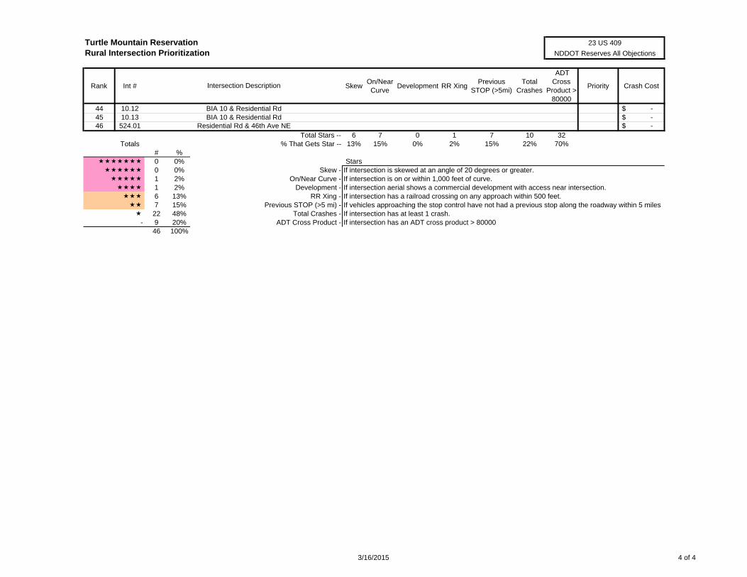
Turtle Mountain ReservationRural Intersection Prioritization
Rank Int # SkewOn/NearCurve
Development RR XingPrevious
STOP (>5mi)Total
Crashes
ADT Cross
Product > 80000
Priority Crash CostIntersection Description
23 US 409
NDDOT Reserves All Objections
44 10.12 -$ 45 10.13 -$ 46 524.01 -$
Total Stars -- 6 7 0 1 7 10 32Totals % That Gets Star -- 13% 15% 0% 2% 15% 22% 70%
# % 0 0% Stars 0 0% Skew - If intersection is skewed at an angle of 20 degrees or greater. 1 2% On/Near Curve - If intersection is on or within 1,000 feet of curve. 1 2% Development - If intersection aerial shows a commercial development with access near intersection. 6 13% RR Xing - If intersection has a railroad crossing on any approach within 500 feet. 7 15% Previous STOP (>5 mi) - If vehicles approaching the stop control have not had a previous stop along the roadway within 5 miles 22 48% Total Crashes - If intersection has at least 1 crash.
- 9 20% ADT Cross Product - If intersection has an ADT cross product > 8000046 100%
BIA 10 & Residential RdBIA 10 & Residential Rd
Residential Rd & 46th Ave NE
3/16/2015 4 of 4
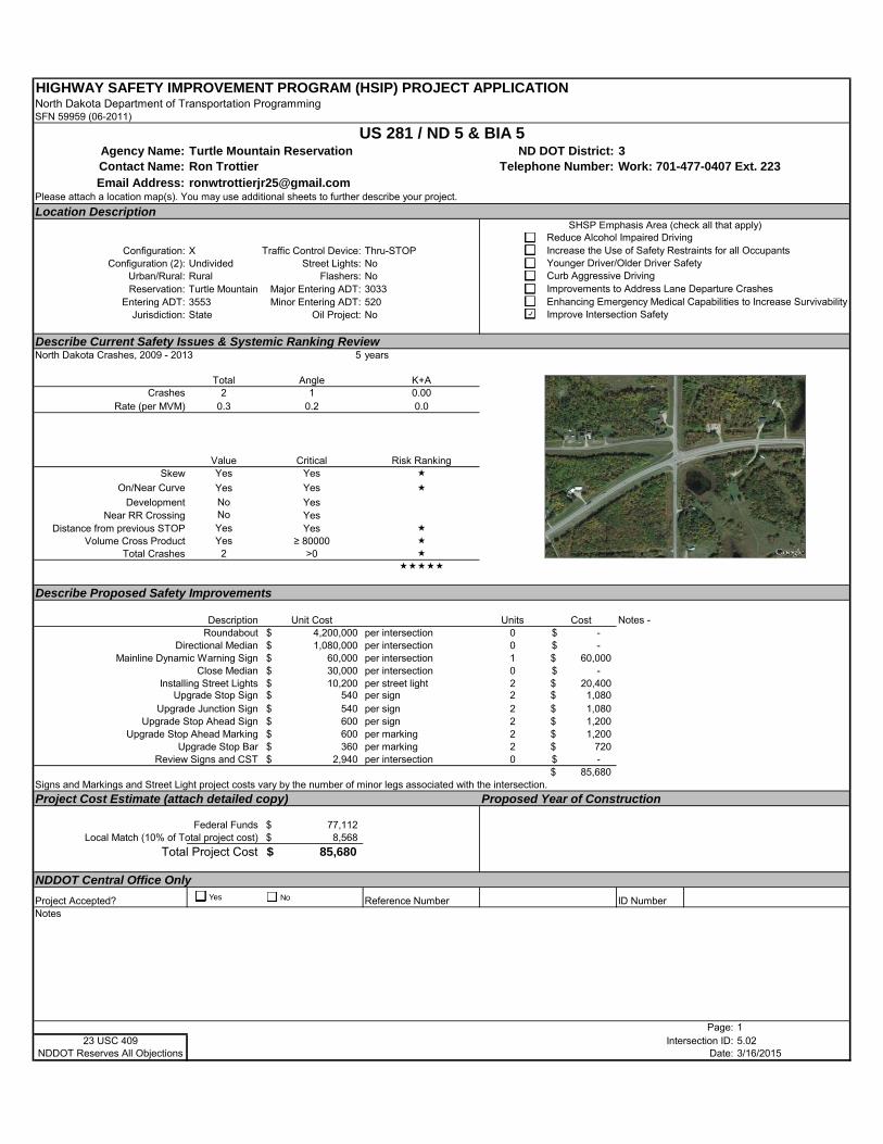
HIGHWAY SAFETY IMPROVEMENT PROGRAM (HSIP) PROJECT APPLICATIONNorth Dakota Department of Transportation ProgrammingSFN 59959 (06-2011)
Agency Name: Turtle Mountain Reservation ND DOT District: 3Contact Name: Ron Trottier Telephone Number: Work: 701-477-0407 Ext. 223Email Address: [email protected]
Please attach a location map(s). You may use additional sheets to further describe your project.
Location Description
Configuration: X Traffic Control Device: Thru-STOPConfiguration (2): Undivided Street Lights: No
Urban/Rural: Rural Flashers: NoReservation: Turtle Mountain Major Entering ADT: 3033
Entering ADT: 3553 Minor Entering ADT: 520Jurisdiction: State Oil Project: No
Describe Current Safety Issues & Systemic Ranking ReviewNorth Dakota Crashes, 2009 - 2013 5 years
Total Angle K+ACrashes 2 1 0.00
Rate (per MVM) 0.3 0.2 0.0
Value Critical Risk RankingSkew Yes Yes
On/Near Curve Yes Yes
Development No YesNear RR Crossing No Yes
Distance from previous STOP Yes Yes Volume Cross Product Yes ≥ 80000
Total Crashes 2 >0
Describe Proposed Safety Improvements
Description Unit Cost Units CostRoundabout 4,200,000$ per intersection 0 -$
Directional Median 1,080,000$ per intersection 0 -$ Mainline Dynamic Warning Sign 60,000$ per intersection 1 60,000$
Close Median 30,000$ per intersection 0 -$ Installing Street Lights 10,200$ per street light 2 20,400$
Upgrade Stop Sign 540$ per sign 2 1,080$ Upgrade Junction Sign 540$ per sign 2 1,080$
Upgrade Stop Ahead Sign 600$ per sign 2 1,200$ Upgrade Stop Ahead Marking 600$ per marking 2 1,200$
Upgrade Stop Bar 360$ per marking 2 720$ Review Signs and CST 2,940$ per intersection 0 -$
85,680$ Signs and Markings and Street Light project costs vary by the number of minor legs associated with the intersection.
Project Cost Estimate (attach detailed copy) Proposed Year of Construction
Federal Funds 77,112$ Local Match (10% of Total project cost) 8,568$
Total Project Cost 85,680$
NDDOT Central Office Only
Project Accepted? Reference Number ID NumberNotes
Page: 123 USC 409 Intersection ID: 5.02
NDDOT Reserves All Objections Date: 3/16/2015
US 281 / ND 5 & BIA 5
Notes -
SHSP Emphasis Area (check all that apply)Reduce Alcohol Impaired DrivingIncrease the Use of Safety Restraints for all OccupantsYounger Driver/Older Driver SafetyCurb Aggressive DrivingImprovements to Address Lane Departure CrashesEnhancing Emergency Medical Capabilities to Increase SurvivabilityImprove Intersection Safety
Yes No
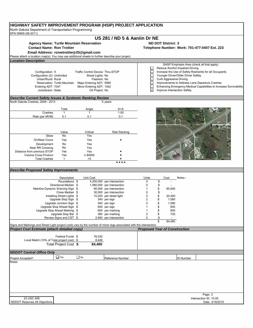
HIGHWAY SAFETY IMPROVEMENT PROGRAM (HSIP) PROJECT APPLICATIONNorth Dakota Department of Transportation ProgrammingSFN 59959 (06-2011)
Agency Name: Turtle Mountain Reservation ND DOT District: 3Contact Name: Ron Trottier Telephone Number: Work: 701-477-0407 Ext. 223Email Address: [email protected]
Please attach a location map(s). You may use additional sheets to further describe your project.
Location Description
Configuration: X Traffic Control Device: Thru-STOPConfiguration (2): Undivided Street Lights: No
Urban/Rural: Rural Flashers: NoReservation: Turtle Mountain Major Entering ADT: 5995
Entering ADT: 7047 Minor Entering ADT: 1052Jurisdiction: State Oil Project: No
Describe Current Safety Issues & Systemic Ranking ReviewNorth Dakota Crashes, 2009 - 2013 5 years
Total Angle K+ACrashes 1 1 1.00
Rate (per MVM) 0.1 0.1 0.1
Value Critical Risk RankingSkew No Yes
On/Near Curve Yes Yes
Development No YesNear RR Crossing No Yes
Distance from previous STOP Yes Yes Volume Cross Product Yes ≥ 80000
Total Crashes 1 >0
Describe Proposed Safety Improvements
Description Unit Cost Units CostRoundabout 4,200,000$ per intersection 0 -$
Directional Median 1,080,000$ per intersection 0 -$ Mainline Dynamic Warning Sign 60,000$ per intersection 1 60,000$
Close Median 30,000$ per intersection 0 -$ Installing Street Lights 10,200$ per street light 2 20,400$
Upgrade Stop Sign 540$ per sign 2 1,080$ Upgrade Junction Sign 540$ per sign 2 1,080$
Upgrade Stop Ahead Sign 600$ per sign 1 600$ Upgrade Stop Ahead Marking 600$ per marking 1 600$
Upgrade Stop Bar 360$ per marking 2 720$ Review Signs and CST 2,940$ per intersection 0 -$
84,480$ Signs and Markings and Street Light project costs vary by the number of minor legs associated with the intersection.
Project Cost Estimate (attach detailed copy) Proposed Year of Construction
Federal Funds 76,032$ Local Match (10% of Total project cost) 8,448$
Total Project Cost 84,480$
NDDOT Central Office Only
Project Accepted? Reference Number ID NumberNotes
Page: 223 USC 409 Intersection ID: 10.05
NDDOT Reserves All Objections Date: 3/16/2015
US 281 / ND 5 & Aaniin Dr NE
Notes -
SHSP Emphasis Area (check all that apply)Reduce Alcohol Impaired DrivingIncrease the Use of Safety Restraints for all OccupantsYounger Driver/Older Driver SafetyCurb Aggressive DrivingImprovements to Address Lane Departure CrashesEnhancing Emergency Medical Capabilities to Increase SurvivabilityImprove Intersection Safety
Yes No
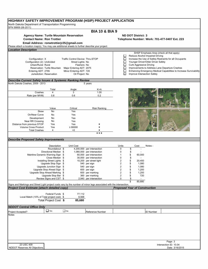
HIGHWAY SAFETY IMPROVEMENT PROGRAM (HSIP) PROJECT APPLICATIONNorth Dakota Department of Transportation ProgrammingSFN 59959 (06-2011)
Agency Name: Turtle Mountain Reservation ND DOT District: 3Contact Name: Ron Trottier Telephone Number: Work: 701-477-0407 Ext. 223Email Address: [email protected]
Please attach a location map(s). You may use additional sheets to further describe your project.
Location Description
Configuration: X Traffic Control Device: Thru-STOPConfiguration (2): Undivided Street Lights: No
Urban/Rural: Rural Flashers: NoReservation: Turtle Mountain Major Entering ADT: 2075
Entering ADT: 2795 Minor Entering ADT: 720Jurisdiction: Reservation Oil Project: No
Describe Current Safety Issues & Systemic Ranking ReviewNorth Dakota Crashes, 2009 - 2013 5 years
Total Angle K+ACrashes 4 3 1.00
Rate (per MVM) 0.8 0.6 0.2
Value Critical Risk RankingSkew No Yes
On/Near Curve No Yes
Development No YesNear RR Crossing No Yes
Distance from previous STOP Yes Yes Volume Cross Product Yes ≥ 80000
Total Crashes 4 >0
Describe Proposed Safety Improvements
Description Unit Cost Units CostRoundabout 4,200,000$ per intersection 0 -$
Directional Median 1,080,000$ per intersection 0 -$ Mainline Dynamic Warning Sign 60,000$ per intersection 1 60,000$
Close Median 30,000$ per intersection 0 -$ Installing Street Lights 10,200$ per street light 2 20,400$
Upgrade Stop Sign 540$ per sign 2 1,080$ Upgrade Junction Sign 540$ per sign 2 1,080$
Upgrade Stop Ahead Sign 600$ per sign 2 1,200$ Upgrade Stop Ahead Marking 600$ per marking 2 1,200$
Upgrade Stop Bar 360$ per marking 2 720$ Review Signs and CST 2,940$ per intersection 0 -$
85,680$ Signs and Markings and Street Light project costs vary by the number of minor legs associated with the intersection.
Project Cost Estimate (attach detailed copy) Proposed Year of Construction
Federal Funds 77,112$ Local Match (10% of Total project cost) 8,568$
Total Project Cost 85,680$
NDDOT Central Office Only
Project Accepted? Reference Number ID NumberNotes
Page: 323 USC 409 Intersection ID: 10.04
NDDOT Reserves All Objections Date: 3/16/2015
BIA 10 & BIA 9
Notes -
SHSP Emphasis Area (check all that apply)Reduce Alcohol Impaired DrivingIncrease the Use of Safety Restraints for all OccupantsYounger Driver/Older Driver SafetyCurb Aggressive DrivingImprovements to Address Lane Departure CrashesEnhancing Emergency Medical Capabilities to Increase SurvivabilityImprove Intersection Safety
Yes No
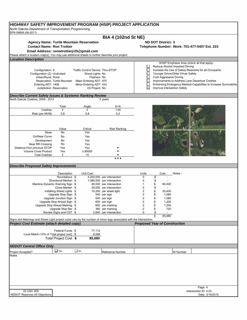
HIGHWAY SAFETY IMPROVEMENT PROGRAM (HSIP) PROJECT APPLICATIONNorth Dakota Department of Transportation ProgrammingSFN 59959 (06-2011)
Agency Name: Turtle Mountain Reservation ND DOT District: 3Contact Name: Ron Trottier Telephone Number: Work: 701-477-0407 Ext. 223Email Address: [email protected]
Please attach a location map(s). You may use additional sheets to further describe your project.
Location Description
Configuration: X Traffic Control Device: Thru-STOPConfiguration (2): Undivided Street Lights: No
Urban/Rural: Rural Flashers: NoReservation: Turtle Mountain Major Entering ADT: 975
Entering ADT: 1408 Minor Entering ADT: 433Jurisdiction: Reservation Oil Project: No
Describe Current Safety Issues & Systemic Ranking ReviewNorth Dakota Crashes, 2009 - 2013 5 years
Total Angle K+ACrashes 2 2 1.00
Rate (per MVM) 0.8 0.8 0.4
Value Critical Risk RankingSkew No Yes
On/Near Curve No Yes
Development No YesNear RR Crossing No Yes
Distance from previous STOP Yes Yes Volume Cross Product Yes ≥ 80000
Total Crashes 2 >0
Describe Proposed Safety Improvements
Description Unit Cost Units CostRoundabout 4,200,000$ per intersection 0 -$
Directional Median 1,080,000$ per intersection 0 -$ Mainline Dynamic Warning Sign 60,000$ per intersection 1 60,000$
Close Median 30,000$ per intersection 0 -$ Installing Street Lights 10,200$ per street light 2 20,400$
Upgrade Stop Sign 540$ per sign 2 1,080$ Upgrade Junction Sign 540$ per sign 2 1,080$
Upgrade Stop Ahead Sign 600$ per sign 2 1,200$ Upgrade Stop Ahead Marking 600$ per marking 2 1,200$
Upgrade Stop Bar 360$ per marking 2 720$ Review Signs and CST 2,940$ per intersection 0 -$
85,680$ Signs and Markings and Street Light project costs vary by the number of minor legs associated with the intersection.
Project Cost Estimate (attach detailed copy) Proposed Year of Construction
Federal Funds 77,112$ Local Match (10% of Total project cost) 8,568$
Total Project Cost 85,680$
NDDOT Central Office Only
Project Accepted? Reference Number ID NumberNotes
Page: 423 USC 409 Intersection ID: 4.03
NDDOT Reserves All Objections Date: 3/16/2015
BIA 4 (102nd St NE)
Notes -
SHSP Emphasis Area (check all that apply)Reduce Alcohol Impaired DrivingIncrease the Use of Safety Restraints for all OccupantsYounger Driver/Older Driver SafetyCurb Aggressive DrivingImprovements to Address Lane Departure CrashesEnhancing Emergency Medical Capabilities to Increase SurvivabilityImprove Intersection Safety
Yes No
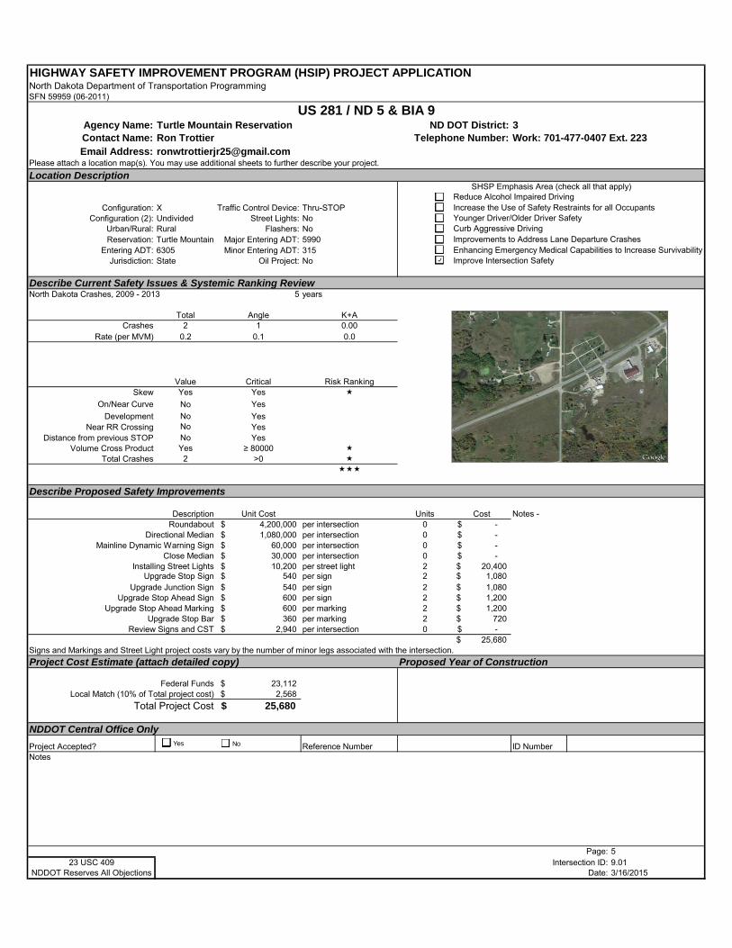
HIGHWAY SAFETY IMPROVEMENT PROGRAM (HSIP) PROJECT APPLICATIONNorth Dakota Department of Transportation ProgrammingSFN 59959 (06-2011)
Agency Name: Turtle Mountain Reservation ND DOT District: 3Contact Name: Ron Trottier Telephone Number: Work: 701-477-0407 Ext. 223Email Address: [email protected]
Please attach a location map(s). You may use additional sheets to further describe your project.
Location Description
Configuration: X Traffic Control Device: Thru-STOPConfiguration (2): Undivided Street Lights: No
Urban/Rural: Rural Flashers: NoReservation: Turtle Mountain Major Entering ADT: 5990
Entering ADT: 6305 Minor Entering ADT: 315Jurisdiction: State Oil Project: No
Describe Current Safety Issues & Systemic Ranking ReviewNorth Dakota Crashes, 2009 - 2013 5 years
Total Angle K+ACrashes 2 1 0.00
Rate (per MVM) 0.2 0.1 0.0
Value Critical Risk RankingSkew Yes Yes
On/Near Curve No Yes
Development No YesNear RR Crossing No Yes
Distance from previous STOP No YesVolume Cross Product Yes ≥ 80000
Total Crashes 2 >0
Describe Proposed Safety Improvements
Description Unit Cost Units CostRoundabout 4,200,000$ per intersection 0 -$
Directional Median 1,080,000$ per intersection 0 -$ Mainline Dynamic Warning Sign 60,000$ per intersection 0 -$
Close Median 30,000$ per intersection 0 -$ Installing Street Lights 10,200$ per street light 2 20,400$
Upgrade Stop Sign 540$ per sign 2 1,080$ Upgrade Junction Sign 540$ per sign 2 1,080$
Upgrade Stop Ahead Sign 600$ per sign 2 1,200$ Upgrade Stop Ahead Marking 600$ per marking 2 1,200$
Upgrade Stop Bar 360$ per marking 2 720$ Review Signs and CST 2,940$ per intersection 0 -$
25,680$ Signs and Markings and Street Light project costs vary by the number of minor legs associated with the intersection.
Project Cost Estimate (attach detailed copy) Proposed Year of Construction
Federal Funds 23,112$ Local Match (10% of Total project cost) 2,568$
Total Project Cost 25,680$
NDDOT Central Office Only
Project Accepted? Reference Number ID NumberNotes
Page: 523 USC 409 Intersection ID: 9.01
NDDOT Reserves All Objections Date: 3/16/2015
US 281 / ND 5 & BIA 9
Notes -
SHSP Emphasis Area (check all that apply)Reduce Alcohol Impaired DrivingIncrease the Use of Safety Restraints for all OccupantsYounger Driver/Older Driver SafetyCurb Aggressive DrivingImprovements to Address Lane Departure CrashesEnhancing Emergency Medical Capabilities to Increase SurvivabilityImprove Intersection Safety
Yes No

HIGHWAY SAFETY IMPROVEMENT PROGRAM (HSIP) PROJECT APPLICATIONNorth Dakota Department of Transportation ProgrammingSFN 59959 (06-2011)
Agency Name: Turtle Mountain Reservation ND DOT District: 3Contact Name: Ron Trottier Telephone Number: Work: 701-477-0407 Ext. 223Email Address: [email protected]
Please attach a location map(s). You may use additional sheets to further describe your project.
Location Description
Configuration: X Traffic Control Device: Thru-STOPConfiguration (2): Undivided Street Lights: No
Urban/Rural: Rural Flashers: NoReservation: Turtle Mountain Major Entering ADT: 1088
Entering ADT: 1528 Minor Entering ADT: 440Jurisdiction: Reservation Oil Project: No
Describe Current Safety Issues & Systemic Ranking ReviewNorth Dakota Crashes, 2009 - 2013 5 years
Total Angle K+ACrashes 1 1 0.00
Rate (per MVM) 0.4 0.4 0.0
Value Critical Risk RankingSkew No Yes
On/Near Curve No Yes
Development No YesNear RR Crossing No Yes
Distance from previous STOP Yes Yes Volume Cross Product Yes ≥ 80000
Total Crashes 1 >0
Describe Proposed Safety Improvements
Description Unit Cost Units CostRoundabout 4,200,000$ per intersection 0 -$
Directional Median 1,080,000$ per intersection 0 -$ Mainline Dynamic Warning Sign 60,000$ per intersection 0 -$
Close Median 30,000$ per intersection 0 -$ Installing Street Lights 10,200$ per street light 2 20,400$
Upgrade Stop Sign 540$ per sign 2 1,080$ Upgrade Junction Sign 540$ per sign 2 1,080$
Upgrade Stop Ahead Sign 600$ per sign 2 1,200$ Upgrade Stop Ahead Marking 600$ per marking 1 600$
Upgrade Stop Bar 360$ per marking 1 360$ Review Signs and CST 2,940$ per intersection 0 -$
24,720$ Signs and Markings and Street Light project costs vary by the number of minor legs associated with the intersection.
Project Cost Estimate (attach detailed copy) Proposed Year of Construction
Federal Funds 22,248$ Local Match (10% of Total project cost) 2,472$
Total Project Cost 24,720$
NDDOT Central Office Only
Project Accepted? Reference Number ID NumberNotes
Page: 623 USC 409 Intersection ID: 8.02
NDDOT Reserves All Objections Date: 3/16/2015
Jack Rabbit Rd/BIA 8 & BIA 10
Notes - Mainline dynamic warning sign project not assigned.
SHSP Emphasis Area (check all that apply)Reduce Alcohol Impaired DrivingIncrease the Use of Safety Restraints for all OccupantsYounger Driver/Older Driver SafetyCurb Aggressive DrivingImprovements to Address Lane Departure CrashesEnhancing Emergency Medical Capabilities to Increase SurvivabilityImprove Intersection Safety
Yes No
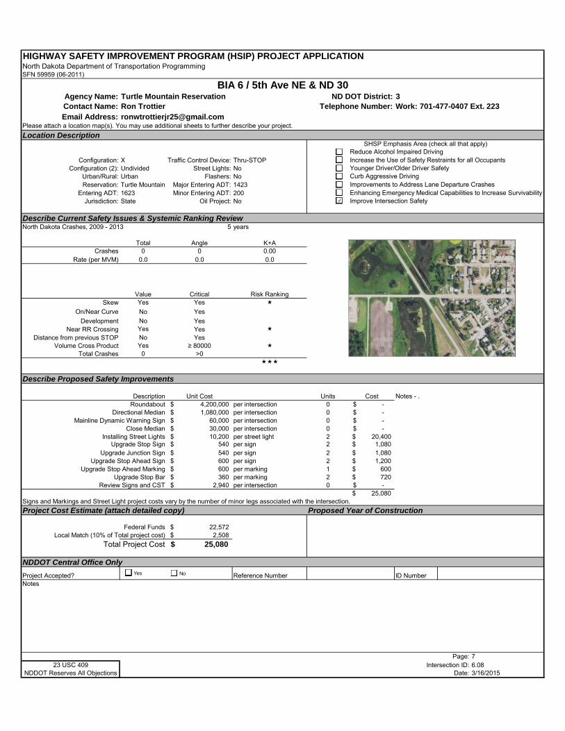
HIGHWAY SAFETY IMPROVEMENT PROGRAM (HSIP) PROJECT APPLICATIONNorth Dakota Department of Transportation ProgrammingSFN 59959 (06-2011)
Agency Name: Turtle Mountain Reservation ND DOT District: 3Contact Name: Ron Trottier Telephone Number: Work: 701-477-0407 Ext. 223Email Address: [email protected]
Please attach a location map(s). You may use additional sheets to further describe your project.
Location Description
Configuration: X Traffic Control Device: Thru-STOPConfiguration (2): Undivided Street Lights: No
Urban/Rural: Urban Flashers: NoReservation: Turtle Mountain Major Entering ADT: 1423
Entering ADT: 1623 Minor Entering ADT: 200Jurisdiction: State Oil Project: No
Describe Current Safety Issues & Systemic Ranking ReviewNorth Dakota Crashes, 2009 - 2013 5 years
Total Angle K+ACrashes 0 0 0.00
Rate (per MVM) 0.0 0.0 0.0
Value Critical Risk RankingSkew Yes Yes
On/Near Curve No Yes
Development No YesNear RR Crossing Yes Yes
Distance from previous STOP No YesVolume Cross Product Yes ≥ 80000
Total Crashes 0 >0
Describe Proposed Safety Improvements
Description Unit Cost Units CostRoundabout 4,200,000$ per intersection 0 -$
Directional Median 1,080,000$ per intersection 0 -$ Mainline Dynamic Warning Sign 60,000$ per intersection 0 -$
Close Median 30,000$ per intersection 0 -$ Installing Street Lights 10,200$ per street light 2 20,400$
Upgrade Stop Sign 540$ per sign 2 1,080$ Upgrade Junction Sign 540$ per sign 2 1,080$
Upgrade Stop Ahead Sign 600$ per sign 2 1,200$ Upgrade Stop Ahead Marking 600$ per marking 1 600$
Upgrade Stop Bar 360$ per marking 2 720$ Review Signs and CST 2,940$ per intersection 0 -$
25,080$ Signs and Markings and Street Light project costs vary by the number of minor legs associated with the intersection.
Project Cost Estimate (attach detailed copy) Proposed Year of Construction
Federal Funds 22,572$ Local Match (10% of Total project cost) 2,508$
Total Project Cost 25,080$
NDDOT Central Office Only
Project Accepted? Reference Number ID NumberNotes
Page: 723 USC 409 Intersection ID: 6.08
NDDOT Reserves All Objections Date: 3/16/2015
BIA 6 / 5th Ave NE & ND 30
Notes - .
SHSP Emphasis Area (check all that apply)Reduce Alcohol Impaired DrivingIncrease the Use of Safety Restraints for all OccupantsYounger Driver/Older Driver SafetyCurb Aggressive DrivingImprovements to Address Lane Departure CrashesEnhancing Emergency Medical Capabilities to Increase SurvivabilityImprove Intersection Safety
Yes No
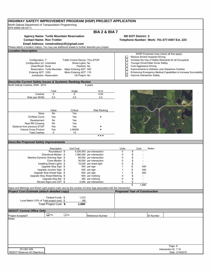
HIGHWAY SAFETY IMPROVEMENT PROGRAM (HSIP) PROJECT APPLICATIONNorth Dakota Department of Transportation ProgrammingSFN 59959 (06-2011)
Agency Name: Turtle Mountain Reservation ND DOT District: 3Contact Name: Ron Trottier Telephone Number: Work: 701-477-0407 Ext. 223Email Address: [email protected]
Please attach a location map(s). You may use additional sheets to further describe your project.
Location Description
Configuration: T Traffic Control Device: Thru-STOPConfiguration (2): Undivided Street Lights: No
Urban/Rural: Rural Flashers: NoReservation: Turtle Mountain Major Entering ADT: 925
Entering ADT: 1035 Minor Entering ADT: 110Jurisdiction: Reservation Oil Project: No
Describe Current Safety Issues & Systemic Ranking ReviewNorth Dakota Crashes, 2009 - 2013 5 years
Total Angle K+ACrashes 0 0 0.00
Rate (per MVM) 0.0 0.0 0.0
Value Critical Risk RankingSkew No Yes
On/Near Curve Yes Yes
Development No YesNear RR Crossing No Yes
Distance from previous STOP Yes Yes Volume Cross Product Yes ≥ 80000
Total Crashes 0 >0
Describe Proposed Safety Improvements
Description Unit Cost Units CostRoundabout 4,200,000$ per intersection 0 -$
Directional Median 1,080,000$ per intersection 0 -$ Mainline Dynamic Warning Sign 60,000$ per intersection 0 -$
Close Median 30,000$ per intersection 0 -$ Installing Street Lights 10,200$ per street light 0 -$
Upgrade Stop Sign 540$ per sign 1 540$ Upgrade Junction Sign 540$ per sign 1 540$
Upgrade Stop Ahead Sign 600$ per sign 1 600$ Upgrade Stop Ahead Marking 600$ per marking 0 -$
Upgrade Stop Bar 360$ per marking 0 -$ Review Signs and CST 2,940$ per intersection 0 -$
1,680$ Signs and Markings and Street Light project costs vary by the number of minor legs associated with the intersection.
Project Cost Estimate (attach detailed copy) Proposed Year of Construction
Federal Funds 1,512$ Local Match (10% of Total project cost) 168$
Total Project Cost 1,680$
NDDOT Central Office Only
Project Accepted? Reference Number ID NumberNotes
Page: 823 USC 409 Intersection ID: 7.10
NDDOT Reserves All Objections Date: 3/16/2015
BIA 2 & BIA 7
Notes -
SHSP Emphasis Area (check all that apply)Reduce Alcohol Impaired DrivingIncrease the Use of Safety Restraints for all OccupantsYounger Driver/Older Driver SafetyCurb Aggressive DrivingImprovements to Address Lane Departure CrashesEnhancing Emergency Medical Capabilities to Increase SurvivabilityImprove Intersection Safety
Yes No
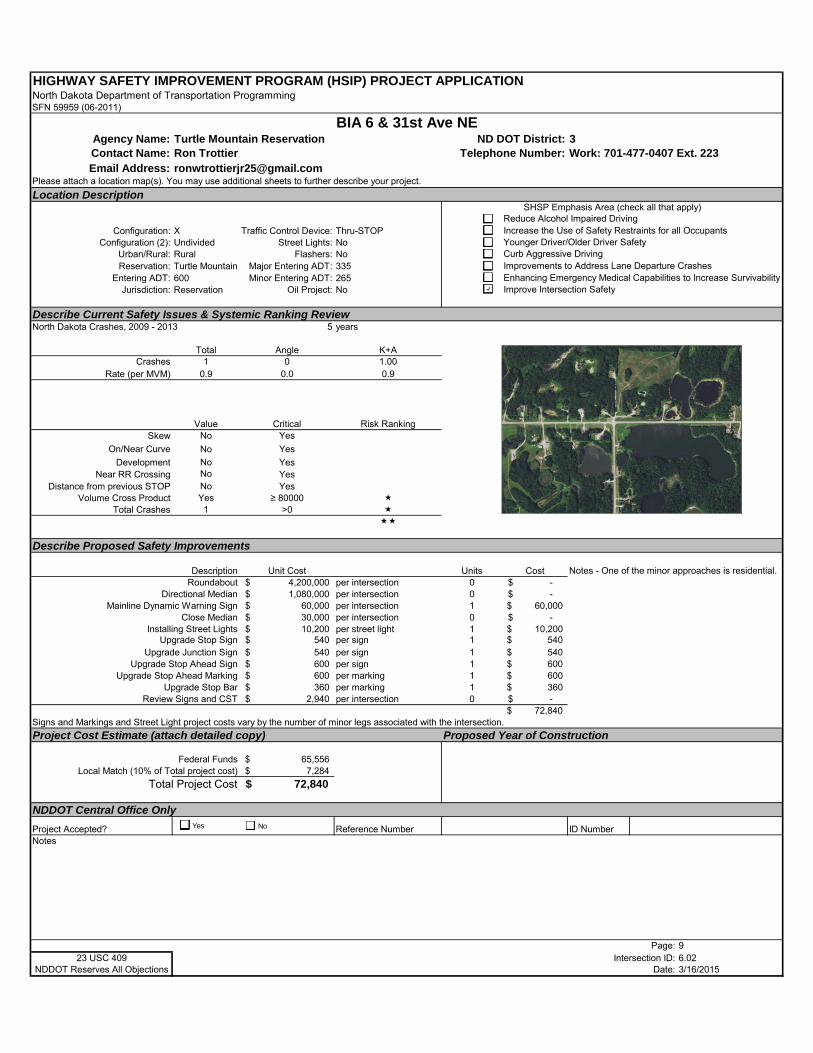
HIGHWAY SAFETY IMPROVEMENT PROGRAM (HSIP) PROJECT APPLICATIONNorth Dakota Department of Transportation ProgrammingSFN 59959 (06-2011)
Agency Name: Turtle Mountain Reservation ND DOT District: 3Contact Name: Ron Trottier Telephone Number: Work: 701-477-0407 Ext. 223Email Address: [email protected]
Please attach a location map(s). You may use additional sheets to further describe your project.
Location Description
Configuration: X Traffic Control Device: Thru-STOPConfiguration (2): Undivided Street Lights: No
Urban/Rural: Rural Flashers: NoReservation: Turtle Mountain Major Entering ADT: 335
Entering ADT: 600 Minor Entering ADT: 265Jurisdiction: Reservation Oil Project: No
Describe Current Safety Issues & Systemic Ranking ReviewNorth Dakota Crashes, 2009 - 2013 5 years
Total Angle K+ACrashes 1 0 1.00
Rate (per MVM) 0.9 0.0 0.9
Value Critical Risk RankingSkew No Yes
On/Near Curve No Yes
Development No YesNear RR Crossing No Yes
Distance from previous STOP No YesVolume Cross Product Yes ≥ 80000
Total Crashes 1 >0
Describe Proposed Safety Improvements
Description Unit Cost Units CostRoundabout 4,200,000$ per intersection 0 -$
Directional Median 1,080,000$ per intersection 0 -$ Mainline Dynamic Warning Sign 60,000$ per intersection 1 60,000$
Close Median 30,000$ per intersection 0 -$ Installing Street Lights 10,200$ per street light 1 10,200$
Upgrade Stop Sign 540$ per sign 1 540$ Upgrade Junction Sign 540$ per sign 1 540$
Upgrade Stop Ahead Sign 600$ per sign 1 600$ Upgrade Stop Ahead Marking 600$ per marking 1 600$
Upgrade Stop Bar 360$ per marking 1 360$ Review Signs and CST 2,940$ per intersection 0 -$
72,840$ Signs and Markings and Street Light project costs vary by the number of minor legs associated with the intersection.
Project Cost Estimate (attach detailed copy) Proposed Year of Construction
Federal Funds 65,556$ Local Match (10% of Total project cost) 7,284$
Total Project Cost 72,840$
NDDOT Central Office Only
Project Accepted? Reference Number ID NumberNotes
Page: 923 USC 409 Intersection ID: 6.02
NDDOT Reserves All Objections Date: 3/16/2015
BIA 6 & 31st Ave NE
Notes - One of the minor approaches is residential.
SHSP Emphasis Area (check all that apply)Reduce Alcohol Impaired DrivingIncrease the Use of Safety Restraints for all OccupantsYounger Driver/Older Driver SafetyCurb Aggressive DrivingImprovements to Address Lane Departure CrashesEnhancing Emergency Medical Capabilities to Increase SurvivabilityImprove Intersection Safety
Yes No
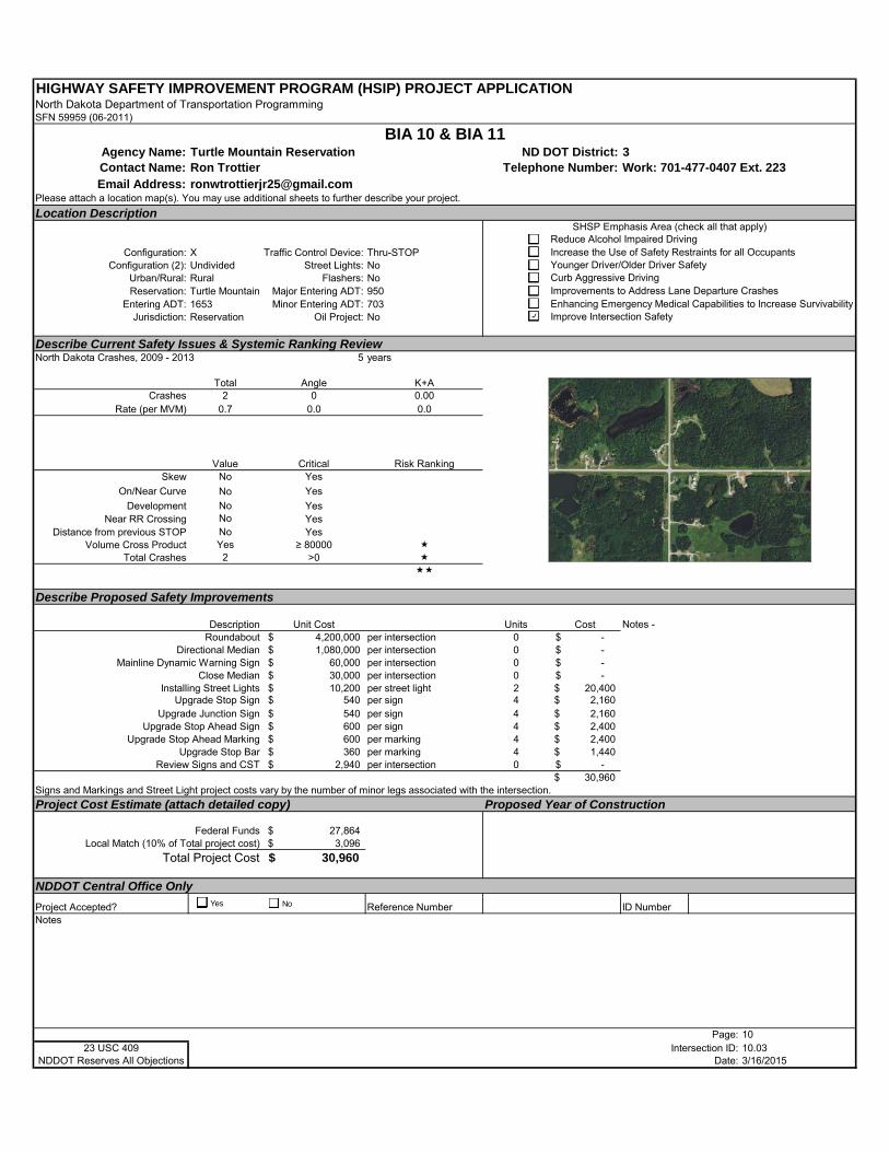
HIGHWAY SAFETY IMPROVEMENT PROGRAM (HSIP) PROJECT APPLICATIONNorth Dakota Department of Transportation ProgrammingSFN 59959 (06-2011)
Agency Name: Turtle Mountain Reservation ND DOT District: 3Contact Name: Ron Trottier Telephone Number: Work: 701-477-0407 Ext. 223Email Address: [email protected]
Please attach a location map(s). You may use additional sheets to further describe your project.
Location Description
Configuration: X Traffic Control Device: Thru-STOPConfiguration (2): Undivided Street Lights: No
Urban/Rural: Rural Flashers: NoReservation: Turtle Mountain Major Entering ADT: 950
Entering ADT: 1653 Minor Entering ADT: 703Jurisdiction: Reservation Oil Project: No
Describe Current Safety Issues & Systemic Ranking ReviewNorth Dakota Crashes, 2009 - 2013 5 years
Total Angle K+ACrashes 2 0 0.00
Rate (per MVM) 0.7 0.0 0.0
Value Critical Risk RankingSkew No Yes
On/Near Curve No Yes
Development No YesNear RR Crossing No Yes
Distance from previous STOP No YesVolume Cross Product Yes ≥ 80000
Total Crashes 2 >0
Describe Proposed Safety Improvements
Description Unit Cost Units CostRoundabout 4,200,000$ per intersection 0 -$
Directional Median 1,080,000$ per intersection 0 -$ Mainline Dynamic Warning Sign 60,000$ per intersection 0 -$
Close Median 30,000$ per intersection 0 -$ Installing Street Lights 10,200$ per street light 2 20,400$
Upgrade Stop Sign 540$ per sign 4 2,160$ Upgrade Junction Sign 540$ per sign 4 2,160$
Upgrade Stop Ahead Sign 600$ per sign 4 2,400$ Upgrade Stop Ahead Marking 600$ per marking 4 2,400$
Upgrade Stop Bar 360$ per marking 4 1,440$ Review Signs and CST 2,940$ per intersection 0 -$
30,960$ Signs and Markings and Street Light project costs vary by the number of minor legs associated with the intersection.
Project Cost Estimate (attach detailed copy) Proposed Year of Construction
Federal Funds 27,864$ Local Match (10% of Total project cost) 3,096$
Total Project Cost 30,960$
NDDOT Central Office Only
Project Accepted? Reference Number ID NumberNotes
Page: 1023 USC 409 Intersection ID: 10.03
NDDOT Reserves All Objections Date: 3/16/2015
BIA 10 & BIA 11
Notes -
SHSP Emphasis Area (check all that apply)Reduce Alcohol Impaired DrivingIncrease the Use of Safety Restraints for all OccupantsYounger Driver/Older Driver SafetyCurb Aggressive DrivingImprovements to Address Lane Departure CrashesEnhancing Emergency Medical Capabilities to Increase SurvivabilityImprove Intersection Safety
Yes No
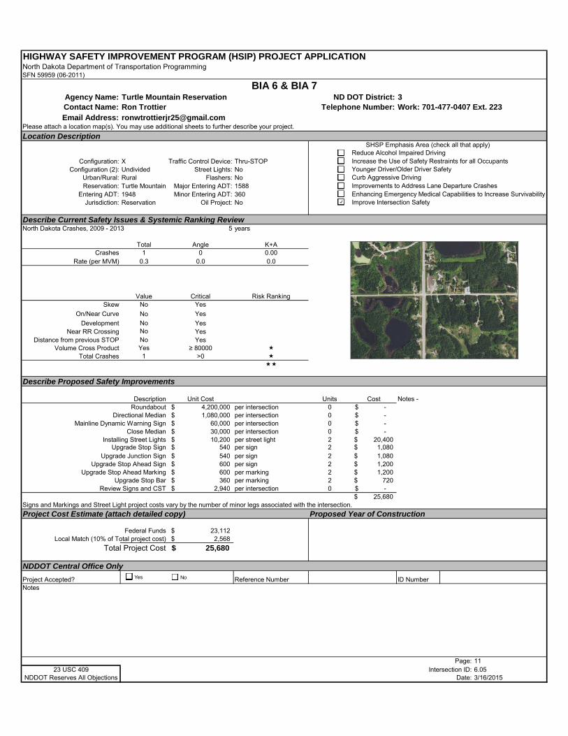
HIGHWAY SAFETY IMPROVEMENT PROGRAM (HSIP) PROJECT APPLICATIONNorth Dakota Department of Transportation ProgrammingSFN 59959 (06-2011)
Agency Name: Turtle Mountain Reservation ND DOT District: 3Contact Name: Ron Trottier Telephone Number: Work: 701-477-0407 Ext. 223Email Address: [email protected]
Please attach a location map(s). You may use additional sheets to further describe your project.
Location Description
Configuration: X Traffic Control Device: Thru-STOPConfiguration (2): Undivided Street Lights: No
Urban/Rural: Rural Flashers: NoReservation: Turtle Mountain Major Entering ADT: 1588
Entering ADT: 1948 Minor Entering ADT: 360Jurisdiction: Reservation Oil Project: No
Describe Current Safety Issues & Systemic Ranking ReviewNorth Dakota Crashes, 2009 - 2013 5 years
Total Angle K+ACrashes 1 0 0.00
Rate (per MVM) 0.3 0.0 0.0
Value Critical Risk RankingSkew No Yes
On/Near Curve No Yes
Development No YesNear RR Crossing No Yes
Distance from previous STOP No YesVolume Cross Product Yes ≥ 80000
Total Crashes 1 >0
Describe Proposed Safety Improvements
Description Unit Cost Units CostRoundabout 4,200,000$ per intersection 0 -$
Directional Median 1,080,000$ per intersection 0 -$ Mainline Dynamic Warning Sign 60,000$ per intersection 0 -$
Close Median 30,000$ per intersection 0 -$ Installing Street Lights 10,200$ per street light 2 20,400$
Upgrade Stop Sign 540$ per sign 2 1,080$ Upgrade Junction Sign 540$ per sign 2 1,080$
Upgrade Stop Ahead Sign 600$ per sign 2 1,200$ Upgrade Stop Ahead Marking 600$ per marking 2 1,200$
Upgrade Stop Bar 360$ per marking 2 720$ Review Signs and CST 2,940$ per intersection 0 -$
25,680$ Signs and Markings and Street Light project costs vary by the number of minor legs associated with the intersection.
Project Cost Estimate (attach detailed copy) Proposed Year of Construction
Federal Funds 23,112$ Local Match (10% of Total project cost) 2,568$
Total Project Cost 25,680$
NDDOT Central Office Only
Project Accepted? Reference Number ID NumberNotes
Page: 1123 USC 409 Intersection ID: 6.05
NDDOT Reserves All Objections Date: 3/16/2015
BIA 6 & BIA 7
Notes -
SHSP Emphasis Area (check all that apply)Reduce Alcohol Impaired DrivingIncrease the Use of Safety Restraints for all OccupantsYounger Driver/Older Driver SafetyCurb Aggressive DrivingImprovements to Address Lane Departure CrashesEnhancing Emergency Medical Capabilities to Increase SurvivabilityImprove Intersection Safety
Yes No

HIGHWAY SAFETY IMPROVEMENT PROGRAM (HSIP) PROJECT APPLICATIONNorth Dakota Department of Transportation ProgrammingSFN 59959 (06-2011)
Agency Name: Turtle Mountain Reservation ND DOT District: 3Contact Name: Ron Trottier Telephone Number: Work: 701-477-0407 Ext. 223Email Address: [email protected]
Please attach a location map(s). You may use additional sheets to further describe your project.
Location Description
Configuration: X Traffic Control Device: Thru-STOPConfiguration (2): Undivided Street Lights: No
Urban/Rural: Rural Flashers: NoReservation: Turtle Mountain Major Entering ADT: 913
Entering ADT: 1253 Minor Entering ADT: 340Jurisdiction: Reservation Oil Project: No
Describe Current Safety Issues & Systemic Ranking ReviewNorth Dakota Crashes, 2009 - 2013 5 years
Total Angle K+ACrashes 1 1 0.00
Rate (per MVM) 0.4 0.4 0.0
Value Critical Risk RankingSkew No Yes
On/Near Curve No Yes
Development No YesNear RR Crossing No Yes
Distance from previous STOP No YesVolume Cross Product Yes ≥ 80000
Total Crashes 1 >0
Describe Proposed Safety Improvements
Description Unit Cost Units CostRoundabout 4,200,000$ per intersection 0 -$
Directional Median 1,080,000$ per intersection 0 -$ Mainline Dynamic Warning Sign 60,000$ per intersection 0 -$
Close Median 30,000$ per intersection 0 -$ Installing Street Lights 10,200$ per street light 2 20,400$
Upgrade Stop Sign 540$ per sign 2 1,080$ Upgrade Junction Sign 540$ per sign 2 1,080$
Upgrade Stop Ahead Sign 600$ per sign 2 1,200$ Upgrade Stop Ahead Marking 600$ per marking 2 1,200$
Upgrade Stop Bar 360$ per marking 2 720$ Review Signs and CST 2,940$ per intersection 0 -$
25,680$ Signs and Markings and Street Light project costs vary by the number of minor legs associated with the intersection.
Project Cost Estimate (attach detailed copy) Proposed Year of Construction
Federal Funds 23,112$ Local Match (10% of Total project cost) 2,568$
Total Project Cost 25,680$
NDDOT Central Office Only
Project Accepted? Reference Number ID NumberNotes
Page: 1223 USC 409 Intersection ID: 8.04
NDDOT Reserves All Objections Date: 3/16/2015
BIA 8 & BIA 9 / 43rd Ave NE
Notes -
SHSP Emphasis Area (check all that apply)Reduce Alcohol Impaired DrivingIncrease the Use of Safety Restraints for all OccupantsYounger Driver/Older Driver SafetyCurb Aggressive DrivingImprovements to Address Lane Departure CrashesEnhancing Emergency Medical Capabilities to Increase SurvivabilityImprove Intersection Safety
Yes No
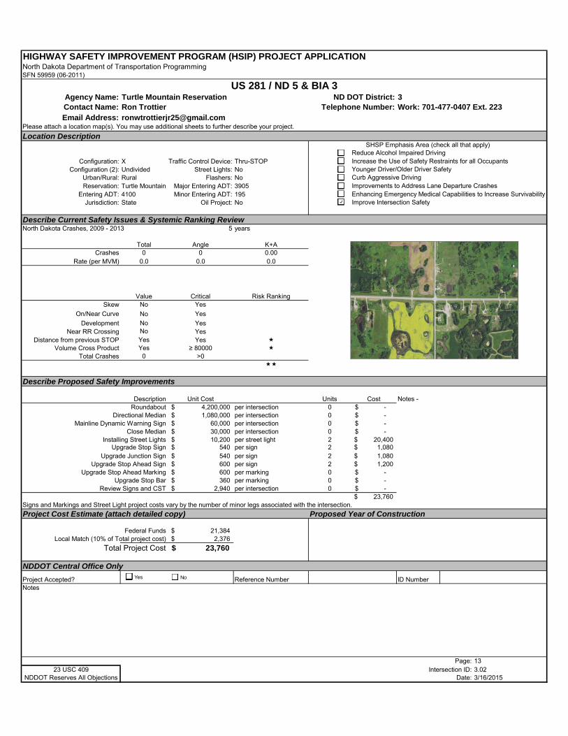
HIGHWAY SAFETY IMPROVEMENT PROGRAM (HSIP) PROJECT APPLICATIONNorth Dakota Department of Transportation ProgrammingSFN 59959 (06-2011)
Agency Name: Turtle Mountain Reservation ND DOT District: 3Contact Name: Ron Trottier Telephone Number: Work: 701-477-0407 Ext. 223Email Address: [email protected]
Please attach a location map(s). You may use additional sheets to further describe your project.
Location Description
Configuration: X Traffic Control Device: Thru-STOPConfiguration (2): Undivided Street Lights: No
Urban/Rural: Rural Flashers: NoReservation: Turtle Mountain Major Entering ADT: 3905
Entering ADT: 4100 Minor Entering ADT: 195Jurisdiction: State Oil Project: No
Describe Current Safety Issues & Systemic Ranking ReviewNorth Dakota Crashes, 2009 - 2013 5 years
Total Angle K+ACrashes 0 0 0.00
Rate (per MVM) 0.0 0.0 0.0
Value Critical Risk RankingSkew No Yes
On/Near Curve No Yes
Development No YesNear RR Crossing No Yes
Distance from previous STOP Yes Yes Volume Cross Product Yes ≥ 80000
Total Crashes 0 >0
Describe Proposed Safety Improvements
Description Unit Cost Units CostRoundabout 4,200,000$ per intersection 0 -$
Directional Median 1,080,000$ per intersection 0 -$ Mainline Dynamic Warning Sign 60,000$ per intersection 0 -$
Close Median 30,000$ per intersection 0 -$ Installing Street Lights 10,200$ per street light 2 20,400$
Upgrade Stop Sign 540$ per sign 2 1,080$ Upgrade Junction Sign 540$ per sign 2 1,080$
Upgrade Stop Ahead Sign 600$ per sign 2 1,200$ Upgrade Stop Ahead Marking 600$ per marking 0 -$
Upgrade Stop Bar 360$ per marking 0 -$ Review Signs and CST 2,940$ per intersection 0 -$
23,760$ Signs and Markings and Street Light project costs vary by the number of minor legs associated with the intersection.
Project Cost Estimate (attach detailed copy) Proposed Year of Construction
Federal Funds 21,384$ Local Match (10% of Total project cost) 2,376$
Total Project Cost 23,760$
NDDOT Central Office Only
Project Accepted? Reference Number ID NumberNotes
Page: 1323 USC 409 Intersection ID: 3.02
NDDOT Reserves All Objections Date: 3/16/2015
US 281 / ND 5 & BIA 3
Notes -
SHSP Emphasis Area (check all that apply)Reduce Alcohol Impaired DrivingIncrease the Use of Safety Restraints for all OccupantsYounger Driver/Older Driver SafetyCurb Aggressive DrivingImprovements to Address Lane Departure CrashesEnhancing Emergency Medical Capabilities to Increase SurvivabilityImprove Intersection Safety
Yes No

HIGHWAY SAFETY IMPROVEMENT PROGRAM (HSIP) PROJECT APPLICATIONNorth Dakota Department of Transportation ProgrammingSFN 59959 (06-2011)
Agency Name: Turtle Mountain Reservation ND DOT District: 3Contact Name: Ron Trottier Telephone Number: Work: 701-477-0407 Ext. 223Email Address: [email protected]
Please attach a location map(s). You may use additional sheets to further describe your project.
Location Description
Configuration: T Traffic Control Device: Thru-STOPConfiguration (2): Undivided Street Lights: No
Urban/Rural: Rural Flashers: NoReservation: Turtle Mountain Major Entering ADT: 180
Entering ADT: 230 Minor Entering ADT: 50Jurisdiction: Reservation Oil Project: No
Describe Current Safety Issues & Systemic Ranking ReviewNorth Dakota Crashes, 2009 - 2013 5 years
Total Angle K+ACrashes 0 0 0.00
Rate (per MVM) 0.0 0.0 0.0
Value Critical Risk RankingSkew Yes Yes
On/Near Curve Yes Yes
Development No YesNear RR Crossing No Yes
Distance from previous STOP No YesVolume Cross Product No ≥ 80000
Total Crashes 0 >0
Describe Proposed Safety Improvements
Description Unit Cost Units CostRoundabout 4,200,000$ per intersection 0 -$
Directional Median 1,080,000$ per intersection 0 -$ Mainline Dynamic Warning Sign 60,000$ per intersection 0 -$
Close Median 30,000$ per intersection 0 -$ Installing Street Lights 10,200$ per street light 0 -$
Upgrade Stop Sign 540$ per sign 1 540$ Upgrade Junction Sign 540$ per sign 1 540$
Upgrade Stop Ahead Sign 600$ per sign 1 600$ Upgrade Stop Ahead Marking 600$ per marking 0 -$
Upgrade Stop Bar 360$ per marking 1 360$ Review Signs and CST 2,940$ per intersection 0 -$
2,040$ Signs and Markings and Street Light project costs vary by the number of minor legs associated with the intersection.
Project Cost Estimate (attach detailed copy) Proposed Year of Construction
Federal Funds 1,836$ Local Match (10% of Total project cost) 204$
Total Project Cost 2,040$
NDDOT Central Office Only
Project Accepted? Reference Number ID NumberNotes
Page: 1423 USC 409 Intersection ID: 13.02
NDDOT Reserves All Objections Date: 3/16/2015
BIA 13 & BIA 6
Notes -
SHSP Emphasis Area (check all that apply)Reduce Alcohol Impaired DrivingIncrease the Use of Safety Restraints for all OccupantsYounger Driver/Older Driver SafetyCurb Aggressive DrivingImprovements to Address Lane Departure CrashesEnhancing Emergency Medical Capabilities to Increase SurvivabilityImprove Intersection Safety
Yes No

HIGHWAY SAFETY IMPROVEMENT PROGRAM (HSIP) PROJECT APPLICATIONNorth Dakota Department of Transportation ProgrammingSFN 59959 (06-2011)
Agency Name: Turtle Mountain Reservation ND DOT District: 3Contact Name: Ron Trottier Telephone Number: Work: 701-477-0407 Ext. 223Email Address: [email protected]
Please attach a location map(s). You may use additional sheets to further describe your project.
Location Description
Configuration: X Traffic Control Device: Thru-STOPConfiguration (2): Undivided Street Lights: No
Urban/Rural: Rural Flashers: NoReservation: Turtle Mountain Major Entering ADT: 5990
Entering ADT: 6162 Minor Entering ADT: 172Jurisdiction: State Oil Project: No
Describe Current Safety Issues & Systemic Ranking ReviewNorth Dakota Crashes, 2009 - 2013 5 years
Total Angle K+ACrashes 0 0 0.00
Rate (per MVM) 0.0 0.0 0.0
Value Critical Risk RankingSkew Yes Yes
On/Near Curve No Yes
Development No YesNear RR Crossing No Yes
Distance from previous STOP No YesVolume Cross Product Yes ≥ 80000
Total Crashes 0 >0
Describe Proposed Safety Improvements
Description Unit Cost Units CostRoundabout 4,200,000$ per intersection 0 -$
Directional Median 1,080,000$ per intersection 0 -$ Mainline Dynamic Warning Sign 60,000$ per intersection 0 -$
Close Median 30,000$ per intersection 0 -$ Installing Street Lights 10,200$ per street light 2 20,400$
Upgrade Stop Sign 540$ per sign 1 540$ Upgrade Junction Sign 540$ per sign 1 540$
Upgrade Stop Ahead Sign 600$ per sign 1 600$ Upgrade Stop Ahead Marking 600$ per marking 1 600$
Upgrade Stop Bar 360$ per marking 1 360$ Review Signs and CST 2,940$ per intersection 0 -$
23,040$ Signs and Markings and Street Light project costs vary by the number of minor legs associated with the intersection.
Project Cost Estimate (attach detailed copy) Proposed Year of Construction
Federal Funds 20,736$ Local Match (10% of Total project cost) 2,304$
Total Project Cost 23,040$
NDDOT Central Office Only
Project Accepted? Reference Number ID NumberNotes
Page: 1523 USC 409 Intersection ID: 200.03
NDDOT Reserves All Objections Date: 3/16/2015
ND 5 / US 281 & 42nd Ave NE
Notes - North leg is driveway access - no signs and markings on that approach
SHSP Emphasis Area (check all that apply)Reduce Alcohol Impaired DrivingIncrease the Use of Safety Restraints for all OccupantsYounger Driver/Older Driver SafetyCurb Aggressive DrivingImprovements to Address Lane Departure CrashesEnhancing Emergency Medical Capabilities to Increase SurvivabilityImprove Intersection Safety
Yes No
TR0119151018SEA 5-1 23 USC 409: NDDOT Reserves All Objections
5.0 Behavioral Safety Strategies
5.1 Purpose of Driver Behavior Safety Strategies North Dakota’s Local Road Safety Program (LRSP) recognizes that driver behavior is a significant factor contributing to a majority of the severe crashes on North Dakota’s local and tribal roads. Traffic crashes may result from any combination of overlapping crash factors, such as the roadway, the vehicle, and driver behavior. Research supports and experts agree that in most cases driver behavior—risky decisions, driver error, lapses of attention, and driver limitations—is a chief factor contributing to traffic crashes (Lerner et al., 2010). Severe traffic crashes in North Dakota’s Central Region can be largely prevented and reduced if motorists, with an emphasis on younger drivers, were persuaded to engage in key safe driving practices to buckle up, drive at safe speeds, pay attention, and plan ahead to avoid impaired driving. For maximum safety benefit, these measures should be undertaken in addition to adopting infrastructure safety strategies to help ensure the safest and most forgiving roadway possible.
5.2 Overview of Behavioral Crash Data for Turtle Mountain Band of Chippewa Indians
Unbelted Vehicle Occupants: Traffic safety research demonstrates that a motorist’s seat belt is the most effective defense in the event of a crash. When lap and shoulder seat belts are used, the risk of fatal injury to front-seat passenger car occupants is reduced by 45 percent and the risk of moderate-to-critical injury is reduced by 50 percent (NHTSA, 2001). Safety benefits are even greater for light-truck occupants, with seat belts reducing fatalities by 60 percent and moderate-to-critical injury by 65 percent (NHTSA, 2009). Seat belts are extremely effective in preventing occupant ejection from the vehicle, the most injurious of crash outcomes (NHTSA, 2014). Reducing unbelted severe crashes is one of Turtle Mountain’s greatest opportunities to strengthen safety on reservation roadways. The trend of severe unbelted crashes is increasing statewide. However, Turtle Mountain is below the 55 percent statewide-unbelted severe crashes with 31% percent of the reservation’s severe crashes involving unbelted motorists.
Alcohol-Related Crashes: Nationally, although impaired driving fatalities have decreased since 2007, the percentage of alcohol-impaired fatalities in the U.S. has remained essentially unchanged (NHTSA, 2012). Similarly, over the last decade, each year nearly half of motor vehicle fatalities statewide in North Dakota continue to be alcohol-related. For Turtle Mountain, alcohol-related severe crashes are much higher at 54 percent than the statewide alcohol-related crashes at 34 percent.
Young Driver-Involved: Young drivers typically have the highest involvement in fatal crashes of any age group. Nationally, the fatal crash involvement of drivers age 16 to 20 is nearly twice that of drivers’ age 21 and older (NHTSA, 2012a). Key underlying factors to their high crash risk are the developmental and behavioral issues of adolescence coupled with driving inexperience. Young drivers too often immaturely take risks while driving without thinking through the potential consequences of their life-threatening decisions (Keating, 2007). Such high-risk behaviors typically include lack of seat belt use, aggressive driving/speeding, and distractions
LOCAL ROAD SAFETY PROGRAM APRIL 2015 CHAPTER 5: BEHAVIORAL STATEGIES
TR0119151018SEA 5-2 23 USC 409: NDDOT Reserves All Objections
while driving. Although severe injury crashes involving young drivers have gradually declined statewide, young drivers under the age of 21 continue to be overrepresented in severe crashes. Turtle Mountain’s severe crashes involving young drivers are similar to the statewide young driver crashes at 23 percent and 24 percent respectively.
Excessive Speed: Speeding is common and the percentage of speeding-related fatal crashes has changed littler over the years. Although drivers generally acknowledge that speeding is an unsafe behavior, speeding remains common because the perceived risk of injury is low relative to the perceived benefits of driving fast such as saving time and driving pleasure (Lerner et al., 2010). Excessive or inappropriate speeds result from two basic problems: drivers choosing to drive above the posted speed limit and drivers driving too fast and failing to adjust speed for accommodate existing road conditions. Consequently, the percentage of speeding-related fatal crashes has remained essentially unchanged over the years and remains a contributing factor in 31 percent of traffic fatalities in the U.S. (NHTSA, 2012b). Speeding and aggressive driving continue to account for 29 percent of all severe crashes in North Dakota. For Turtle Mountain, speed or aggressive driving accounts for 31 percent of its severe injury crashes.
5.3 Importance of Traffic Safety Culture Change 5.3.1 The Influence of Traffic Safety Culture Turtle Mountain, together with its traffic safety partners, seeks to develop and implement traffic safety strategies within the broader societal context of motorists’ behavior and the reservation’s traffic safety culture. Traffic safety culture can be defined as the implicit shared values, beliefs, and perceptions that shape motorists’ behavior.
5.3.2 Social Norms Inhibiting a Strong Traffic Safety Culture At the core of the nation’s and tribal reservations’ traffic safety challenge is complacency toward risk-taking by drivers and a tolerance for traffic crashes and the resulting deaths and serious injuries. Contributing factors include a sense of individual driver invulnerability, perceived driving skills and vehicle control, and a sense of anonymity and entitlement on the road. The latest data from the 2012 Traffic Safety Culture Index Survey reports that, as in previous years, the safety culture in the United States surrounding distracted driving can best be described as “do as I say, not as I do” — due to the high numbers of people who object to certain behaviors, yet will admit that they, themselves, engage in them (AAA, 2012). Real progress in traffic safety depends largely on addressing and changing this culture of indifference to effectively implement and see results from tribal safety strategies.
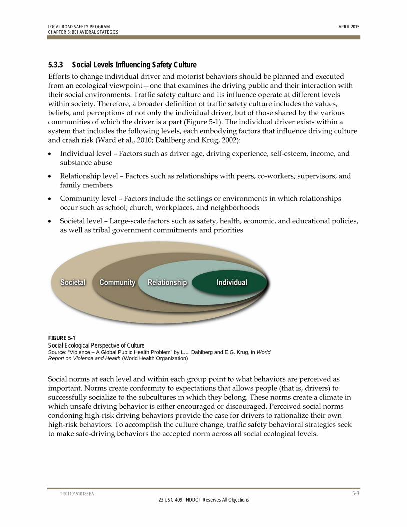
LOCAL ROAD SAFETY PROGRAM APRIL 2015 CHAPTER 5: BEHAVIORAL STATEGIES
TR0119151018SEA 5-3 23 USC 409: NDDOT Reserves All Objections
5.3.3 Social Levels Influencing Safety Culture Efforts to change individual driver and motorist behaviors should be planned and executed from an ecological viewpoint—one that examines the driving public and their interaction with their social environments. Traffic safety culture and its influence operate at different levels within society. Therefore, a broader definition of traffic safety culture includes the values, beliefs, and perceptions of not only the individual driver, but of those shared by the various communities of which the driver is a part (Figure 5-1). The individual driver exists within a system that includes the following levels, each embodying factors that influence driving culture and crash risk (Ward et al., 2010; Dahlberg and Krug, 2002):
Individual level – Factors such as driver age, driving experience, self-esteem, income, and substance abuse
Relationship level – Factors such as relationships with peers, co-workers, supervisors, and family members
Community level – Factors include the settings or environments in which relationships occur such as school, church, workplaces, and neighborhoods
Societal level – Large-scale factors such as safety, health, economic, and educational policies, as well as tribal government commitments and priorities
FIGURE 5-1 Social Ecological Perspective of Culture Source: “Violence – A Global Public Health Problem” by L.L. Dahlberg and E.G. Krug, in World Report on Violence and Health (World Health Organization)
Social norms at each level and within each group point to what behaviors are perceived as important. Norms create conformity to expectations that allows people (that is, drivers) to successfully socialize to the subcultures in which they belong. These norms create a climate in which unsafe driving behavior is either encouraged or discouraged. Perceived social norms condoning high-risk driving behaviors provide the case for drivers to rationalize their own high-risk behaviors. To accomplish the culture change, traffic safety behavioral strategies seek to make safe-driving behaviors the accepted norm across all social ecological levels.
LOCAL ROAD SAFETY PROGRAM APRIL 2015 CHAPTER 5: BEHAVIORAL STATEGIES
TR0119151018SEA 5-4 23 USC 409: NDDOT Reserves All Objections
The implication of the social ecological model for LRSP and tribal road safety efforts is that implementation plans should attempt to:
Increase perceived social pressure to comply with traffic safety laws and practices, thereby, producing safety behavioral norms (Ward et al., 2010)
Shift the social acceptance of high-risk behaviors to one of perceived unacceptance by significant others and one’s peers.
5.4 Behavioral Safety Strategies 5.4.1 Role of Policy, Education, and Enforcement Techniques or strategies to change driver behavior essentially fall into one of three categories: 1) policy change or change to tribal traffic safety codes, regulations, sanctions and penalties; 2) enforcement of the laws; and 3) education or public information, media, and training. These three categories of behavioral safety strategies work together to have the greatest impact on changing risky driver behavior. The degree of effectiveness of any one strategy on behavioral change depends not only on how effectively the strategy is implemented, but also on how these three categories of policy, enforcement, and education are working together.
For example, if Turtle Mountain is seeking to increase motorists’ seat belt use and decides to use a “buckle up” public information campaign (behavioral change strategy). The effectiveness of the campaign not only depends on the quality of the education or public information campaign (relevance to target group, duration, saturation of the messaging), but also the strength of the tribal law in place (primary vs. secondary seat belt law; all passengers vs. front seat only; higher penalty/fee vs. low penalty/fee) and, most important, the degree of seat belt use enforcement (enforcement coverage, intensity, visible by the public).
Consequently, the strength of driver safety policy, enforcement, and education surrounding a behavioral strategy selected greatly impact its effectiveness. Therefore, when selecting and implementing a behavioral strategy, tribal leaders must examine the related policy or tribal laws, enforcement available, and the supporting educational and public outreach available to support the strategy and explore ways to strengthen each, as appropriate, to gain the most safety benefit from a selected strategy.
Finally, it is critically important that traffic safety enforcement is viewed as a priority within the tribal community and its leadership, the tribal council. It is imperative that tribal leaders actively address political and community resistance and provide a pathway to deploy the leading safety strategy to save lives on Turtle Mountain’s roadways—effective traffic enforcement coupled with public outreach. By advocating for enforcement, educating tribal council members, and equipping officers to effectively enforce traffic safety laws, Turtle Mountain will reap far greater life-saving outcomes from its local safety initiatives.
5.4.2 Effective Use of Public Information Strategies Public information (education) strategies are often popular among communities seeking to change risky driving behaviors. Education or public information campaigns can range from brochures and mailings to peer-to-peer safety messaging. Brochures and mailings are a passive approach, while peer-to-peer messaging provides a more effective behavioral change approach. In general, a key challenge in influencing driver behavior is that most drivers know what they
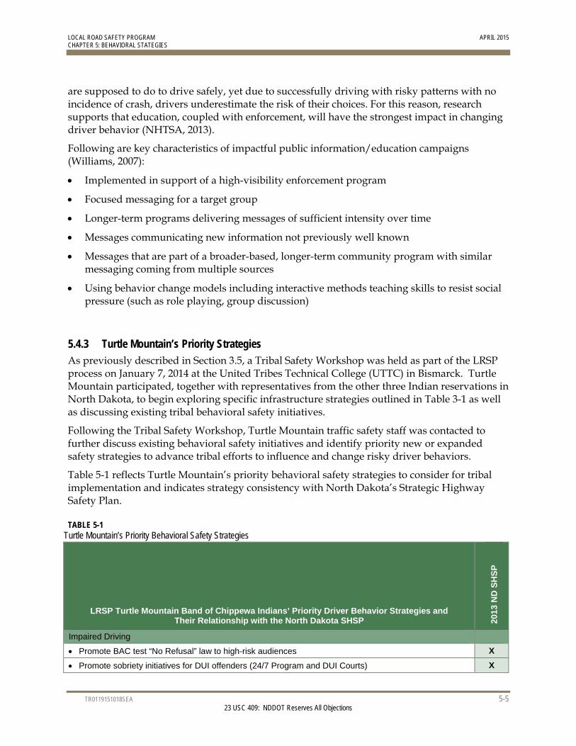
LOCAL ROAD SAFETY PROGRAM APRIL 2015 CHAPTER 5: BEHAVIORAL STATEGIES
TR0119151018SEA 5-5 23 USC 409: NDDOT Reserves All Objections
are supposed to do to drive safely, yet due to successfully driving with risky patterns with no incidence of crash, drivers underestimate the risk of their choices. For this reason, research supports that education, coupled with enforcement, will have the strongest impact in changing driver behavior (NHTSA, 2013).
Following are key characteristics of impactful public information/education campaigns (Williams, 2007):
Implemented in support of a high-visibility enforcement program
Focused messaging for a target group
Longer-term programs delivering messages of sufficient intensity over time
Messages communicating new information not previously well known
Messages that are part of a broader-based, longer-term community program with similar messaging coming from multiple sources
Using behavior change models including interactive methods teaching skills to resist social pressure (such as role playing, group discussion)
5.4.3 Turtle Mountain’s Priority Strategies As previously described in Section 3.5, a Tribal Safety Workshop was held as part of the LRSP process on January 7, 2014 at the United Tribes Technical College (UTTC) in Bismarck. Turtle Mountain participated, together with representatives from the other three Indian reservations in North Dakota, to begin exploring specific infrastructure strategies outlined in Table 3-1 as well as discussing existing tribal behavioral safety initiatives.
Following the Tribal Safety Workshop, Turtle Mountain traffic safety staff was contacted to further discuss existing behavioral safety initiatives and identify priority new or expanded safety strategies to advance tribal efforts to influence and change risky driver behaviors.
Table 5-1 reflects Turtle Mountain’s priority behavioral safety strategies to consider for tribal implementation and indicates strategy consistency with North Dakota’s Strategic Highway Safety Plan.
TABLE 5-1 Turtle Mountain’s Priority Behavioral Safety Strategies
LRSP Turtle Mountain Band of Chippewa Indians’ Priority Driver Behavior Strategies and Their Relationship with the North Dakota SHSP 20
13
ND
SH
SP
Impaired Driving
Promote BAC test “No Refusal” law to high-risk audiences X
Promote sobriety initiatives for DUI offenders (24/7 Program and DUI Courts) X
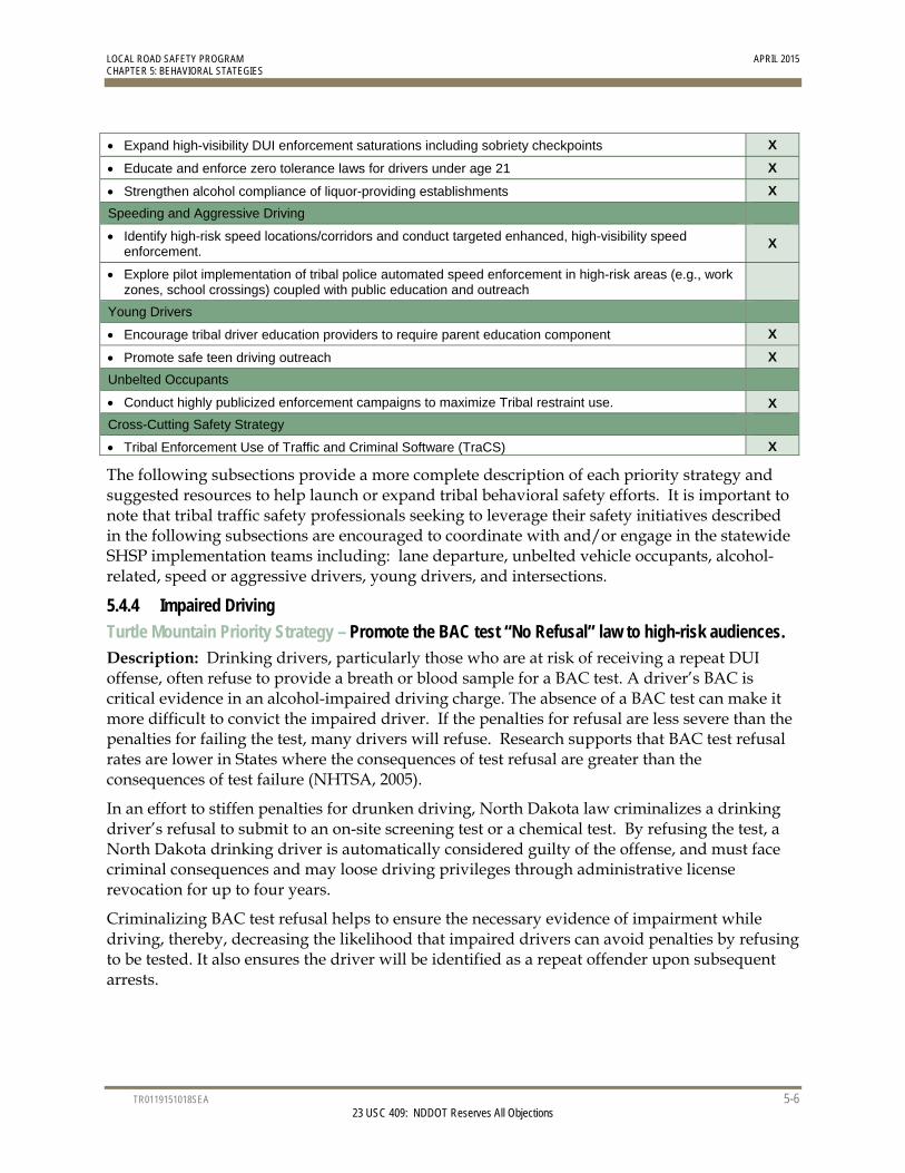
LOCAL ROAD SAFETY PROGRAM APRIL 2015 CHAPTER 5: BEHAVIORAL STATEGIES
TR0119151018SEA 5-6 23 USC 409: NDDOT Reserves All Objections
Expand high-visibility DUI enforcement saturations including sobriety checkpoints X
Educate and enforce zero tolerance laws for drivers under age 21 X
Strengthen alcohol compliance of liquor-providing establishments X
Speeding and Aggressive Driving
Identify high-risk speed locations/corridors and conduct targeted enhanced, high-visibility speed enforcement.
X
Explore pilot implementation of tribal police automated speed enforcement in high-risk areas (e.g., work zones, school crossings) coupled with public education and outreach
Young Drivers
Encourage tribal driver education providers to require parent education component X
Promote safe teen driving outreach X
Unbelted Occupants
Conduct highly publicized enforcement campaigns to maximize Tribal restraint use. X
Cross-Cutting Safety Strategy
Tribal Enforcement Use of Traffic and Criminal Software (TraCS) X
The following subsections provide a more complete description of each priority strategy and suggested resources to help launch or expand tribal behavioral safety efforts. It is important to note that tribal traffic safety professionals seeking to leverage their safety initiatives described in the following subsections are encouraged to coordinate with and/or engage in the statewide SHSP implementation teams including: lane departure, unbelted vehicle occupants, alcohol-related, speed or aggressive drivers, young drivers, and intersections.
5.4.4 Impaired Driving
Turtle Mountain Priority Strategy – Promote the BAC test “No Refusal” law to high-risk audiences. Description: Drinking drivers, particularly those who are at risk of receiving a repeat DUI offense, often refuse to provide a breath or blood sample for a BAC test. A driver’s BAC is critical evidence in an alcohol-impaired driving charge. The absence of a BAC test can make it more difficult to convict the impaired driver. If the penalties for refusal are less severe than the penalties for failing the test, many drivers will refuse. Research supports that BAC test refusal rates are lower in States where the consequences of test refusal are greater than the consequences of test failure (NHTSA, 2005).
In an effort to stiffen penalties for drunken driving, North Dakota law criminalizes a drinking driver’s refusal to submit to an on-site screening test or a chemical test. By refusing the test, a North Dakota drinking driver is automatically considered guilty of the offense, and must face criminal consequences and may loose driving privileges through administrative license revocation for up to four years.
Criminalizing BAC test refusal helps to ensure the necessary evidence of impairment while driving, thereby, decreasing the likelihood that impaired drivers can avoid penalties by refusing to be tested. It also ensures the driver will be identified as a repeat offender upon subsequent arrests.
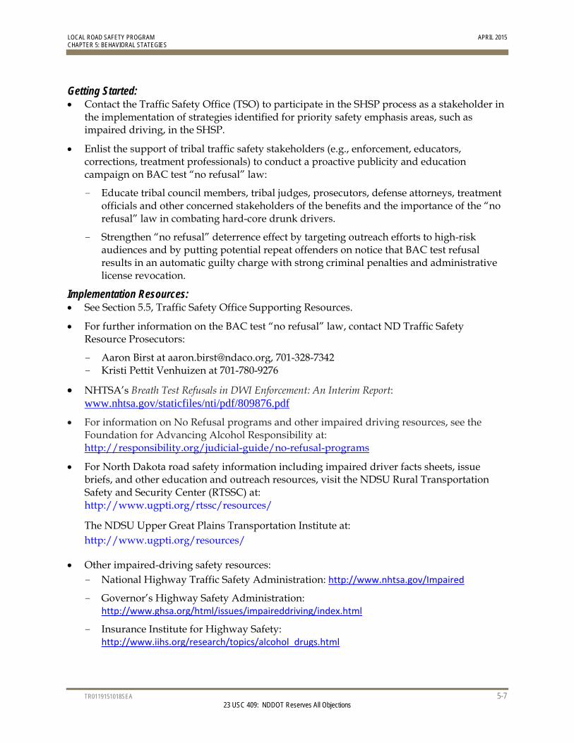
LOCAL ROAD SAFETY PROGRAM APRIL 2015 CHAPTER 5: BEHAVIORAL STATEGIES
TR0119151018SEA 5-7 23 USC 409: NDDOT Reserves All Objections
Getting Started: Contact the Traffic Safety Office (TSO) to participate in the SHSP process as a stakeholder in
the implementation of strategies identified for priority safety emphasis areas, such as impaired driving, in the SHSP.
Enlist the support of tribal traffic safety stakeholders (e.g., enforcement, educators, corrections, treatment professionals) to conduct a proactive publicity and education campaign on BAC test “no refusal” law:
- Educate tribal council members, tribal judges, prosecutors, defense attorneys, treatment officials and other concerned stakeholders of the benefits and the importance of the “no refusal” law in combating hard-core drunk drivers.
- Strengthen “no refusal” deterrence effect by targeting outreach efforts to high-risk audiences and by putting potential repeat offenders on notice that BAC test refusal results in an automatic guilty charge with strong criminal penalties and administrative license revocation.
Implementation Resources: See Section 5.5, Traffic Safety Office Supporting Resources.
For further information on the BAC test “no refusal” law, contact ND Traffic Safety Resource Prosecutors:
- Aaron Birst at [email protected], 701-328-7342 - Kristi Pettit Venhuizen at 701-780-9276
NHTSA’s Breath Test Refusals in DWI Enforcement: An Interim Report: www.nhtsa.gov/staticfiles/nti/pdf/809876.pdf
For information on No Refusal programs and other impaired driving resources, see the Foundation for Advancing Alcohol Responsibility at: http://responsibility.org/judicial-guide/no-refusal-programs
For North Dakota road safety information including impaired driver facts sheets, issue briefs, and other education and outreach resources, visit the NDSU Rural Transportation Safety and Security Center (RTSSC) at: http://www.ugpti.org/rtssc/resources/
The NDSU Upper Great Plains Transportation Institute at: http://www.ugpti.org/resources/
Other impaired-driving safety resources: - National Highway Traffic Safety Administration: http://www.nhtsa.gov/Impaired
- Governor’s Highway Safety Administration: http://www.ghsa.org/html/issues/impaireddriving/index.html
- Insurance Institute for Highway Safety: http://www.iihs.org/research/topics/alcohol_drugs.html
LOCAL ROAD SAFETY PROGRAM APRIL 2015 CHAPTER 5: BEHAVIORAL STATEGIES
TR0119151018SEA 5-8 23 USC 409: NDDOT Reserves All Objections
Turtle Mountain Priority Strategy – Promote Sobriety Initiatives for DUI Offenders – 24/7 and DUI Courts. Description: To reduce impaired driving on tribal roadways, in addition to regular high-visibility DUI enforcement saturation patrols and DUI sobriety checkpoints, Turtle Mountain is encouraged to further incorporate 24/7 program components and explore DUI court programs to effectively monitor hardcore DUI offenders. Most hardcore repeat DUI offenders are alcohol dependent and often unable to control their drinking and driving behavior. For this reason, these programs are proven effective in combating impaired driving.
24/7 – North Dakota’s 24/7 Sobriety Program provides an alternative to jail time for DUI offenders charged with or convicted of two or more or drunk driving offenses; first-time drunk driving offenders under the age of 18 are also required to participate in the 24/7 program. The program requires offenders to abstain from alcohol use and submit to sobriety testing twice per day through preliminary breath test (PBTs) or through continuous monitoring via a SCRAM; requiring sobriety 24 hours per day, 7 days per week. If the arrestee’s test registers any alcohol use then he or she is immediately taken into custody. If the arrestee fails to show for testing, his or her jail bond is revoked. An offender may participate in the 24/7 Sobriety Program as a condition of bond or pre-trial release and to participate in the program as a condition of sentence or probation.
DUI Courts – North Dakota’s four Drug/DUI Courts are hybrid courts; namely, they are drug courts that also work with DUI offenders. North Dakota Drug/DUI Courts are an effective tool to combat the hardcore impaired driver by using intensive supervision and treatment to change the offender’s behavior. DUI Courts use all the criminal justice stakeholders (judge, prosecutor, defense attorney, law enforcement, probation, and treatment) using a cooperative approach to change the offender’s behavior by meeting regularly as a team to discuss the status of each offender’s case and to assure that alcohol treatment and all sentencing requirements are satisfied. With the input of all parties, tribal judges are more informed and can immediately revise restrictions when necessary.
Getting Started: Contact the Traffic Safety Office (TSO) to participate in the SHSP process as a stakeholder in
the implementation of strategies identified for priority safety emphasis areas, such as impaired driving, in the SHSP.
Enlist the support of tribal traffic safety stakeholders to conduct a proactive publicity and education campaign on 24/7 and DUI Courts to:
- Educate tribal council members, tribal judges, prosecutors, defense attorneys, treatment officials and other concerned stakeholders of the importance of 24/7 and DUI court programs in combating hard core drunk drivers.
- Educate the public on the nature of the impaired driving problem on the reservations and how these tools will provide necessary sanctions on the offenders as well as enhance the safety of all roadway users; and
- Act as a general deterrent by putting potential offenders on notice that if they are arrested for impaired driving they may become subject to a highly supervised sanction with the costs and stigma associated with its use.
LOCAL ROAD SAFETY PROGRAM APRIL 2015 CHAPTER 5: BEHAVIORAL STATEGIES
TR0119151018SEA 5-9 23 USC 409: NDDOT Reserves All Objections
Explore the tribal adoption of ignition interlock devices preventing DUI offenders from operating a vehicle if the offender has been drinking. Before starting the vehicle, the driver must breathe into the device and if the driver’s breath alcohol reading is above a preset blood alcohol concentration (BAC) limit, the interlock device will not allow the vehicle to start. In North Dakota, the use of alcohol ignition interlocks is discretionary for all DUI offenders.
Implementation Resources: See Section 5.5, Traffic Safety Office Supporting Resources.
For assistance with ND sobriety initiatives (24/7, DUI/Drug Courts) and for DUI data sources, contact ND Traffic Safety Resource Prosecutors:
- Aaron Birst at [email protected], 701-328-7342 - Kristi Pettit Venhuizen at 701-780-9276
For location information on ND DUI/Drug Courts, see: http://ndadcp.org/courts.html
For information on the North Dakota’s 24/7 Program: http://www.ag.nd.gov/TwentyFourSeven/
The National Center for DWI Courts provides quick reference information for traffic safety stakeholders and policy makers on what they need to know about DUI courts: http://www.dwicourts.org/sites/default/files/ncdc/The%20Bottom%20Line.pdf http://www.dwicourts.org/node/98
For a helpful overview of alcohol interlocks and their use as well as public outreach talking points, see Ignition Interlocks - What You Need to Know: A Toolkit for Policymakers, Highway Safety Professionals, and Advocates at: http://www.nhtsa.gov/staticfiles/nti/pdf/IgnitionInterlocks_811883.pdf
For North Dakota road safety information including impaired driver facts sheets, issue briefs, and other education and outreach resources, visit the NDSU Rural Transportation Safety and Security Center (RTSSC) at: http://www.ugpti.org/rtssc/resources/
The NDSU Upper Great Plains Transportation Institute at: http://www.ugpti.org/resources/
Other impaired-driving safety resources: - National Highway Traffic Safety Administration: http://www.nhtsa.gov/Impaired
- Governor’s Highway Safety Administration: http://www.ghsa.org/html/issues/impaireddriving/index.html
- Insurance Institute for Highway Safety: http://www.iihs.org/research/topics/alcohol_drugs.html
Turtle Mountain Priority Strategy – Expand the use of high-visibility DUI enforcement saturation patrols including sobriety checkpoints. Description: High-visibility DUI enforcement is a high-priority, proven safety strategy to reduce alcohol-impaired severe crashes across the reservation. The most effective way to deter
LOCAL ROAD SAFETY PROGRAM APRIL 2015 CHAPTER 5: BEHAVIORAL STATEGIES
TR0119151018SEA 5-10 23 USC 409: NDDOT Reserves All Objections
impaired driving is through a highly visible enforcement effort to reinforce the tribal members’ belief that impaired drivers are at high risk of being arrested, prosecuted, and adjudicated. High-visibility enforcement consists of multiple jurisdictions and/or multiple squads patrolling a segment of roadway at the same time, often using brightly colored vests and signs. Planned enforcement is publicized extensively through tribal community kickoff events involving the media, social media, and public education campaigns about the enforcement. In addition to deterring driving after drinking by increasing the perceived risk of arrest, high-visibility enforcement extends the safety impact of the enforcement campaign for a longer period following the campaign.
What are saturation patrols? Saturation patrols, also known as “dedicated DUI patrols,” are stepped-up enforcement involving a greater number of enforcement officers patrolling a specific area for a set time to identify and arrest impaired drivers. Multiple agencies often combine and concentrate their resources with a defined roadway segment to conduct saturation patrols.
What are sobriety checkpoints? At sobriety checkpoints, tribal enforcement officials evaluate drivers for signs of alcohol or drug impairment at certain points on the roadway. Vehicles are stopped in a specific sequence, such as every other vehicle or every fourth, fifth, etc. The frequency of which vehicles are stopped depends on the traffic conditions and the number of enforcement personnel available to staff the checkpoint.
Getting Started: Contact the Traffic Safety Office (TSO) to participate in the SHSP process as a stakeholder in
the implementation of strategies identified for priority safety emphasis areas, such as impaired driving, in the SHSP.
Explore enforcement saturation and high-visibility enforcement cooperative agreements through piloting limited weekend agreements between tribal police and ND Highway Patrol, BIA, and/or local sheriff and police to strengthen enforcement presence and community impact.
Tribal law enforcement, together with Tribal behavioral safety and traffic engineering staff, attend Tribal Council and community leadership meetings to speak on the importance of reducing impaired driving and the important role of both enforcement and engineering safety strategies working together to save lives on Tribal roads.
Utilize Traffic Safety Office’s DUI campaign materials to conduct community outreach on high-visibility enforcement campaigns.
Implementation Resources: For crash data to focus DUI enforcement efforts, contact the NDDOT Traffic Safety Office
(TSO) at (701) 328-4692.
To learn about traffic safety enforcement activities and enforcement grant opportunities, contact the TSO and the TSO Law Enforcement Liaison.
See Section 5.5, Traffic Safety Office Supporting Resources.

LOCAL ROAD SAFETY PROGRAM APRIL 2015 CHAPTER 5: BEHAVIORAL STATEGIES
TR0119151018SEA 5-11 23 USC 409: NDDOT Reserves All Objections
For statewide impaired-driving enforcement mobilizations, the TSO distributes media outreach materials to enforcement agencies, which may include press releases, talking points, camera-ready artwork and posters, impaired driving fact sheets, handouts for the public at checkpoints, a print public service announcement (PSA), and live-read radio PSAs. (Note: TSO to assemble available information resources.)
For guidance on planning and publicizing saturation patrols and sobriety checkpoints:
- Saturation Patrols & Sobriety Checkpoints: A How-to Guide for Planning and Publicizing Impaired Driving Enforcement Efforts, NHTSA, Report No. DOT HS 809 063, revised October 2002. http://www.nhtsa.gov/people/injury/alcohol/saturation_patrols/
- Low-Staffing Sobriety Checkpoints. NHTSA, Report No. DOT HS 810 590, 2006. http://www.nhtsa.gov/people/injury/enforce/LowStaffing_Checkpoints/
For information on the effective adjudication of DUI arrests and to inquire about DUI data sources, contact ND Traffic Safety Resource Prosecutors:
- Aaron Birst at [email protected], 701-328-7342 - Kristi Pettit Venhuizen at 701/780-9276
For North Dakota road safety information including impaired driver facts sheets, issue briefs, and other education and outreach resources, visit the NDSU Rural Transportation Safety and Security Center (RTSSC) at: http://www.ugpti.org/rtssc/resources/
The NDSU Upper Great Plains Transportation Institute at: http://www.ugpti.org/resources/
Other impaired-driving safety resources:
- National Highway Traffic Safety Administration: http://www.nhtsa.gov/Impaired
- Governor’s Highway Safety Administration: http://www.ghsa.org/html/issues/impaireddriving/index.html
- Insurance Institute for Highway Safety: http://www.iihs.org/research/topics/alcohol_drugs.html
LOCAL ROAD SAFETY PROGRAM APRIL 2015 CHAPTER 5: BEHAVIORAL STATEGIES
TR0119151018SEA 5-12 23 USC 409: NDDOT Reserves All Objections
Turtle Mountain Region Priority Strategy – Educate and Enforce Zero Tolerance Laws for Drivers under Age 21 Description: Turtle Mountain has a zero tolerance standard for anyone under the age of 21 operating a motor vehicle. Under North Dakota’s “Use/Lose Laws,” when minors measure a BAC of 0.02 or above, there is loss of driving privileges. The North Dakota Highway Patrol receives and distributes Enforcement of Underage Drinking Laws (EUDL) funds provided by the North Dakota Department of Human Services (federal Office of Juvenile Justice and Delinquency Prevention [OJJDP] funding). These funds are used by the Highway Patrol and dispersed to local law enforcement to facilitate underage drinking enforcement efforts across the state. The Highway Patrol participates with local law enforcement in multiagency efforts to stop underage drinking and driving using the following strategies to enforce Zero Tolerance Laws:
Cops in Shops Shoulder Tap Operations Party Patrol Operations Compliance Checks Underage Alcohol–Related Fatality Investigations
In addition, Turtle Mountain enforcement participates in the national impaired driving prevention campaign, Driver Sober or Get Pulled Over, to ensure high visibility enforcement including North Dakota’s zero-tolerance law for those under age 21.
In addition to enforcement, research demonstrates the primary role of parents in shaping their children’s decision to not drink. To support parents’ healthy influence, North Dakota’s comprehensive Parents LEAD (Listen, Educate, Ask, Discuss) program is a primary resource for local traffic safety partners to engage parents to discuss the topic of underage drinking on an ongoing basis with their younger and adult children. Finally, OJJDP program outreach also provides information on social hosting, parental involvement, and consequences of underage drinking.
Getting Started Contact the Traffic Safety Office (TSO) to participate in the SHSP process as a stakeholder in
the implementation of strategies identified for priority safety emphasis areas, such as impaired driving, in the SHSP.
Inquire about and support Tribal enforcement efforts to actively enforce laws and programs that fight underage drinking. For example, when an underage drinker is involved in a traffic crash, find out how the youths obtained the alcohol, then hold whoever gave or sold it to them accountable.
The TSO may offer grant funds for law enforcement to conduct alcohol compliance checks and server training programs; other communities conduct server training as required through city or county ordinances including Dickinson, Fargo, Grand Forks and Williston.
The North Dakota Department of Human Services (DHS) administers funds from the Federal Office of Juvenile Justice and Delinquency Prevention (OJJDP) which allowed state and local law enforcement to deter underage drinking through various enforcement strategies (compliance checks, shoulder taps, saturation, and party patrols). OJJDP program
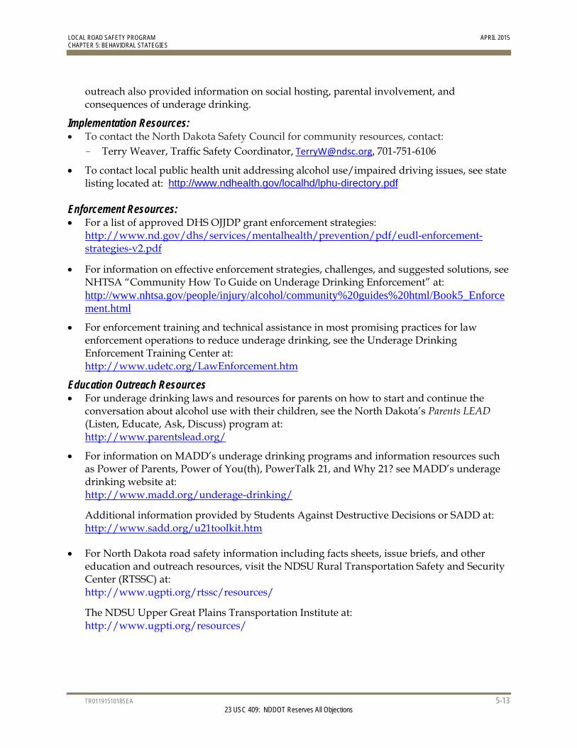
LOCAL ROAD SAFETY PROGRAM APRIL 2015 CHAPTER 5: BEHAVIORAL STATEGIES
TR0119151018SEA 5-13 23 USC 409: NDDOT Reserves All Objections
outreach also provided information on social hosting, parental involvement, and consequences of underage drinking.
Implementation Resources: To contact the North Dakota Safety Council for community resources, contact:
- Terry Weaver, Traffic Safety Coordinator, [email protected], 701-751-6106
To contact local public health unit addressing alcohol use/impaired driving issues, see state listing located at: http://www.ndhealth.gov/localhd/lphu-directory.pdf
Enforcement Resources: For a list of approved DHS OJJDP grant enforcement strategies:
http://www.nd.gov/dhs/services/mentalhealth/prevention/pdf/eudl-enforcement-strategies-v2.pdf
For information on effective enforcement strategies, challenges, and suggested solutions, see NHTSA “Community How To Guide on Underage Drinking Enforcement” at: http://www.nhtsa.gov/people/injury/alcohol/community%20guides%20html/Book5_Enforcement.html
For enforcement training and technical assistance in most promising practices for law enforcement operations to reduce underage drinking, see the Underage Drinking Enforcement Training Center at: http://www.udetc.org/LawEnforcement.htm
Education Outreach Resources For underage drinking laws and resources for parents on how to start and continue the
conversation about alcohol use with their children, see the North Dakota’s Parents LEAD (Listen, Educate, Ask, Discuss) program at: http://www.parentslead.org/
For information on MADD’s underage drinking programs and information resources such as Power of Parents, Power of You(th), PowerTalk 21, and Why 21? see MADD’s underage drinking website at: http://www.madd.org/underage-drinking/
Additional information provided by Students Against Destructive Decisions or SADD at: http://www.sadd.org/u21toolkit.htm
For North Dakota road safety information including facts sheets, issue briefs, and other education and outreach resources, visit the NDSU Rural Transportation Safety and Security Center (RTSSC) at: http://www.ugpti.org/rtssc/resources/
The NDSU Upper Great Plains Transportation Institute at: http://www.ugpti.org/resources/
LOCAL ROAD SAFETY PROGRAM APRIL 2015 CHAPTER 5: BEHAVIORAL STATEGIES
TR0119151018SEA 5-14 23 USC 409: NDDOT Reserves All Objections
Turtle Mountain Priority Strategy – Strengthen alcohol compliance of liquor-providing establishments. Description: Liquor-providing establishments include bars, restaurants, and retail (convenience and liquor) stores. Strengthening the compliance of alcohol-related laws by these establishments includes advocating for responsible alcohol server and retailer training and compliance checks along with promoting judicial monitoring of “last place of drink” for bar-related DUI offenders and notifying establishments of their over-serving.
Responsible alcohol servers engage in alcohol sales policies and practices that prevent or discourage restaurant and bar patrons from drinking to excess, which can prevent patrons from driving while impaired. Likewise, responsible servers and retailers do not sell to underage people (NCHRP, 2005). Mandatory training programs can teach servers how to recognize the signs of intoxication and how to prevent intoxicated patrons from further drinking and from driving. With this knowledge, servers can refuse additional alcohol sales and assist with arranging alternative transportation. Training can also decrease the likelihood that alcohol will be sold to people under the legal drinking age. To achieve maximum effectiveness, employee training must be supported and promoted by management policies and programs such as limits on cheap drinks and other promotions, support for designated driver programs, strong commitment to server training, and strong support for servers who refuse alcohol to intoxicated patrons. Strong advocacy for training and associated policies will help to encourage management support for and compliance with responsible beverage service practices.
Tribal enforcement officers can conduct frequent compliance checks to reduce the likelihood that servers and retailers sell alcohol to underage people. To conduct a compliance check, officers watch as underage people attempt to purchase alcohol and cite the server or retailer for a violation if a sale is made (NHTSA, 2013). Because an effective compliance check program works primarily through deterrence, the goal is to increase the perception of being caught by sellers and purchasers (NHTSA, 2013). Strong and continued advocacy for compliance checks will help reduce the likelihood that underage people have access to alcohol and the potential to drive while impaired.
“Last place of drink” is a program in which tribal enforcement officers record the establishment (bar or restaurant) where a person involved in a DUI incident consumed their last alcoholic beverage prior to driving (Kringen, Mikkelson, Nesbitt). Review of this documentation can highlight alcohol-related trends including day of week, time, and particular establishments that have the highest frequencies of serving the last drink. With this information, officers can better focus their efforts in both educating and enforcing retailers about their violations and work with them to improve their serving practices. More responsible beverage service could reduce the potential for alcohol-related crashes on the reservation.
Getting Started: Contact the NDDOT Traffic Safety Office (TSO) to participate in the SHSP process as a
stakeholder in the implementation of strategies identified for priority safety emphasis areas, such as speeding and aggressive driving, in the SHSP.
Explore tribal ordinances requiring all liquor establishment owners, managers, and servers complete a standardized responsible beverage service training course as a condition for an
LOCAL ROAD SAFETY PROGRAM APRIL 2015 CHAPTER 5: BEHAVIORAL STATEGIES
TR0119151018SEA 5-15 23 USC 409: NDDOT Reserves All Objections
alcohol retailer obtaining and maintaining a license (or permit). Note: Several North Dakota cities mandate server training within city limits.
Promote tribal enforcement and on-sale liquor establishments identified as having higher levels of customer drinking and driving incidents to develop and implement preventative action plans.
Support tribal enforcement to strengthen compliance checks of alcohol retailers for sales to underage patrons.
Implementation Resources: For a standardized curriculum for server training programs used by Safe Communities and
law enforcement, contact the NDDOT Traffic Safety Office (701) 328-4692.
For a sample presentation for responsible beverage service prepared by the Minnesota Department of Public Safety, Office of Alcohol and Gambling Enforcement Division, see: https://dps.mn.gov/pages/Results.aspx?k=responsible%20beverage%20service%20training
For information about on-line responsible beverage service training and certification, see: http://www.suresellnow.com/
For descriptions of alcohol control policies to reduce youth access to alcohol from both social and commercial sources as well as links to resources including the Alcohol Compliance Check Manual, see: http://www.aep.umn.edu/index.php/aep-tools/underage-access
For information on implementing a “last place of drink” program, contact Minnesota Department of Public Safety Alcohol and Gambling Enforcement Division: Brian Kringen, [email protected]
5.4.5 Speed and Aggressive Driving
Turtle Mountain Priority Strategy – Identify high-risk speed locations/corridors and conduct targeted enhanced, high-visibility speed enforcement. Description: Identifying problem locations that have a high rate of speeding-related crashes are at the heart of an effective speed enforcement program. Enforcement and the associated public outreach efforts are most successful when deployed at specific locations or corridors and times when speeding is most likely to occur. Strengthened analysis of the following sources of data and information provides the focus needed for more effective, targeted enforcement and public outreach to reduce speed-related severe crashes:
1. Current and historical crash records and citation data 2. Engineering traffic and speed data 3. Law enforcement experience 3. Tribal council and member input
See Section 5.4.4 priority strategy, Expand the use of high-visibility DUI enforcement saturation patrols including sobriety checkpoints, for a full description of high-visibility/highly publicized enforcement campaigns.
LOCAL ROAD SAFETY PROGRAM APRIL 2015 CHAPTER 5: BEHAVIORAL STATEGIES
TR0119151018SEA 5-16 23 USC 409: NDDOT Reserves All Objections
North Dakota law enforcement agencies (state, county, city, and tribal) participate in the state’s cooperative enforcement programs to reduce speeding-related fatalities and incapacitating injuries by stepped up enforcement of aggressive drivers of cars and trucks primarily in oil-production-impacted counties. For aggressive driving enforcement, officers focus on drivers who commit a combination of moving traffic violations such speeding, following too closely, and/or running red lights that endanger other persons or property.
Getting Started: Contact the Traffic Safety Office (TSO) to participate in the SHSP process as a stakeholder in
the implementation of strategies identified for priority safety emphasis areas, such as speed and aggressive driving, in the SHSP.
Contact Tribal transportation engineering staff for assistance with analyzing crashes and traffic data to identify locations with speed and aggressive driving-related crash involvement for high-visibility enforcement.
Experience in other states suggests that rural road segments or corridors that have a higher density of road departure crashes have also been found to have a higher density for speed/aggressive driving and other behavioral-related crashes. Therefore, for suggested locations for enhanced enforcement, see tribal-specific priority locations for rural road segments at risk for lane departure in this report’s Chapter 4 Appendix. (Note: HSIP flex funds may be used for overtime enforcement at at-risk locations for lane departure.)
Note on at-risk lane departure infrastructure safety strategies: To reduce lane departure severe crashes on rural paved roads, the Turtle Mountain may be deploying infrastructure safety improvements (e.g., centerline rumble strips, edge line rumble strips, adding or widening edge lines, high visibility pavement markings) at select at-risk corridors. To maximize the expected safety benefit of the road improvements, integrating increased enforcement presence at targeted at-risk locations and timeframes will reduce risky driver behaviors through strengthening the public’s perceived risk of being stopped.
Tribal law enforcement, together with tribal behavioral safety and traffic engineering staff, attend Tribal Council and community leadership meetings to speak on the importance of enforcing the speed limits and reducing aggressive driving and the importance of enforcement and engineering safety strategies working together to save lives on Tribal roads.
Collaborate with highway patrol, local law enforcement, community health officials, and local traffic safety stakeholders to use NDDOT Traffic Safety Office speed campaign materials to conduct community outreach on the speed enforcement campaign.
Implementation Resources: For crash data and analysis to focus speed enforcement efforts, which may include the
development of electronic pin maps of speed-related crash locations, contact the NDDOT Traffic Safety Office (TSO) at (701) 328-4692.
To learn about local traffic safety enforcement initiatives and enforcement grant opportunities, contact the TSO and the state’s Law Enforcement Liaison at (701) 328-4692. Enforcement grant application information for overtime speed enforcement can be found at: https://www.dot.nd.gov/divisions/safety/trafficsafety.htm
LOCAL ROAD SAFETY PROGRAM APRIL 2015 CHAPTER 5: BEHAVIORAL STATEGIES
TR0119151018SEA 5-17 23 USC 409: NDDOT Reserves All Objections
See Section 5.5, Traffic Safety Office Supporting Resources.
For speed-related crash data by County, see: 2013 North Dakota Crash Summary see: http://www.dot.nd.gov/divisions/safety/docs/crash-summary.pdf
For a successful model of data-driven traffic enforcement, see Washington State’s Target Zero Team project where planners use GIS mapping software to guide Target Zero patrols to where crashes were occurring and which roads led to high-collision areas at: http://www.wsp.wa.gov/targetzero/targetzero.htm#tzt
For guidance on data-driven speed enforcement, see:
NHTSA’s Speed Enforcement Program Guidelines at: http://safety.fhwa.dot.gov/speedmgt/ref_mats/fhwasa09028/resources/Speed%20Enforcement%20Program%20Guidelines.pdf#page=1
National Cooperative Highway Research Program (NCHRP) Report 500, Vol. 23: Guidance for Implementation of the AASHTO Strategic Highway Safety Plan: A Guide for Reducing Speeding-Related Crashes at: http://onlinepubs.trb.org/onlinepubs/nchrp/nchrp_rpt_500v23.pdf
For guidance for law enforcement on planning and publicizing local speed saturation patrols and successful case examples, see NHTSA’s Guidelines for Developing a Municipal Speed Enforcement Program at: http://www.nhtsa.dot.gov/people/injury/enforce/program.htm
For a summary of successful aggressive driving enforcement programs deployed at the local and state-level across the country, see NHTSA’s Aggressive Driving Enforcement: Strategies for Implementing Best Practices at: http://www.nhtsa.gov/people/injury/enforce/aggressdrivers/aggenforce/
Other speed-related safety resources:
Governor’s Highway Safety Administration: http://www.ghsa.org/html/issues/speeding.html
Insurance Institute for Highway Safety: http://www.iihs.org/iihs/topics/t/speed/topicoverview
For North Dakota road safety information including speed facts sheets, issue briefs, and other education and outreach resources, visit the NDSU Rural Transportation Safety and Security Center (RTSSC) at: http://www.ugpti.org/rtssc/resources/
The NDSU Upper Great Plains Transportation Institute at: http://www.ugpti.org/resources/
Turtle Mountain Priority Strategy – Explore pilot implementation of Tribal police automated speed enforcement in high-risk areas coupled with public education and outreach. Description: To encourage compliance with posted speed limits and improve the efficiency and effectiveness of enforcing them, automated speed enforcement can be deployed simultaneously at multiple locations across the reservation. The devices are ideally located on high-speed roads
LOCAL ROAD SAFETY PROGRAM APRIL 2015 CHAPTER 5: BEHAVIORAL STATEGIES
TR0119151018SEA 5-18 23 USC 409: NDDOT Reserves All Objections
where speeding is a known issue and on roads where traditional traffic stops are difficult or dangerous. Automated speed enforcement is a tool that helps to maximize limited available tribal traffic safety enforcement resources on the reservation. Because the devices can operate 24 hours a day/7 days a week, they enable BIA and/or tribal police to have a greater impact on improving traffic safety without increasing personnel or operating costs.
These devices, known as speed cameras or photo radar, record a vehicle’s speed using radar or some other type of speed measuring instrumentation. When the vehicle speed exceeds a threshold limit set by tribal staff and/or law enforcement (such as 10 miles per hour 10 [mph] over the posted speed limit), the camera takes a photograph of the vehicle license plate (NHTSA, 2013). The photograph and recorded data about speed, time, and date are electronically sent to tribal law enforcement personnel. Speeding citations can then be automatically issued to the vehicle owner (it is difficult to identify the driver from the photograph and, therefore, less effective to issue citations to the driver).
Studies conducted in the United States indicate that speed cameras are proven effective in reducing vehicle travel speeds (TRB, 2009). The cameras’ presence strengthens the public’s perception that if driving above a speed limit threshold, a speed citation will be issued. Studies suggest that a successful introduction of automated speed enforcement promotes public support (TRB, 2009). Therefore, it is suggested that tribal engineering and enforcement staff, explore pilot implementation of speed camera located where the public perceives speeding to be of greater concern, such as school crossings, work zones, and neighborhoods. Strong public education and outreach on the public safety benefits is critical for successful tribal community adoption of automated speed enforcement cameras.
Getting Started: Contact the Traffic Safety Office (TSO) to participate in the SHSP process as a stakeholder in
the implementation of strategies identified for priority safety emphasis areas, such as speeding and aggressive driving, in the SHSP.
Tribal law enforcement and traffic safety engineering staff collaborate with NDDOT Traffic Operations Section to explore suggested pilot speed camera project locations from a traffic crash history perspective. Contact NDDOT Traffic Operations Section, Shawn Kuntz, (701) 328-2673.
Tribal law enforcement, together with tribal behavioral safety and traffic engineering staff, attend Tribal Council and community leadership meetings to educate about the community safety benefits and to develop support for automated speed enforcement and the pilot application of the technology in high-risk tribal areas.
Tribal law enforcement and traffic safety engineering staff to meet with tribal court personnel to promote understanding of automated speed technology, the pilot demonstration locations, and to promote the willingness to prosecute violators and the court’s upholding of charges and conviction of violators.
Implementation Resources: For supporting crash data and analysis to focus automated enforcement efforts, contact the
NDDOT Traffic Safety Office (TSO) at (701) 328-4692.
LOCAL ROAD SAFETY PROGRAM APRIL 2015 CHAPTER 5: BEHAVIORAL STATEGIES
TR0119151018SEA 5-19 23 USC 409: NDDOT Reserves All Objections
Work with NDDOT staff regarding specific design features of the system. Contact NDDOT Traffic Operations Section, Shawn Kuntz, (701) 328-2673.
See Section 5.5, Traffic Safety Office Supporting Resources.
Transportation Research Board: Special Report 254 Managing Speed. http://onlinepubs.trb.org/onlinepubs/sr/sr254.pdf.
Intelligent Transportation Systems Institute: Final Report Identifying Issues Related to Automated Speed Enforcement. http://safety.fhwa.dot.gov/speedmgt/ref_mats/fhwasa1304/1_48.htm.
National Highway Traffic Safety Administration: Speed Enforcement Program Guidelines.
Other speed-related safety resources:
Governor’s Highway Safety Administration: http://www.ghsa.org/html/issues/speeding.html
Insurance Institute for Highway Safety: http://www.iihs.org/iihs/topics/t/speed/topicoverview
For North Dakota road safety information including speed facts sheets, issue briefs, and other education and outreach resources, visit the NDSU Rural Transportation Safety and Security Center (RTSSC) at: http://www.ugpti.org/rtssc/resources/
The NDSU Upper Great Plains Transportation Institute at: http://www.ugpti.org/resources/
5.4.6 Young Drivers
Turtle Mountain Priority Strategy – Encourage tribal driver education providers (local schools and private providers) to require a parent education component Description: Effective parental monitoring of teen driving can go a long way in helping to keep novice drivers safe on the roadway. Programs offering teen driver safety materials together with facilitated guidance help parents make the important connection between teen driving restrictions and teen driving risks. Without a required parent component for teen driver education, parents lack awareness of graduated driver license (GDL) safety provisions, don’t fully recognize teen driving risks, are often anxious to be relieved from shuttling their teens, may be reluctant to invest the necessary time to instruct and supervise their teen’s driving, and often believe their teen is the exception and is a good and safe driver. Incorporating a parent education component into driver education programs is demonstrating promising results in overcoming these parent challenges and more effectively engaging parents.
Key components of a good parent education program include:
Discusses risks for novice teen drivers Explains how and why GDL works to address the driving risks for young drivers Reviews the critical role parents play in teaching, supporting, and managing their novice
drivers
LOCAL ROAD SAFETY PROGRAM APRIL 2015 CHAPTER 5: BEHAVIORAL STATEGIES
TR0119151018SEA 5-20 23 USC 409: NDDOT Reserves All Objections
Explains the importance of and provides an opportunity to try out a parent/teen driving agreement
Delivery by trained, educated facilitators Emphasizes parents and teens working together for safety
Getting Started: Contact the Traffic Safety Office (TSO) to participate in the SHSP process as a stakeholder in
the implementation of strategies identified for priority safety emphasis areas, such as young drivers, in the SHSP.
With local law enforcement and driver educators, Tribal Council and community leadership meetings to promote the tribal initiative to incorporate parent education into driver education programs to more fully engage parents and reduce severe young driver crashes.
Post information on teen driving laws on tribal school websites or request school resource officer to send information to parents highlighting driving risks for teens and existing North Dakota teen driver laws.
Consider linking parent-teen participation in a teen-driving program to school parking privileges.
Implementation Resources: See Section 5.5, Traffic Safety Office Supporting Resources.
For educational materials for parents of teen drivers including guidelines to ensure teen drivers are educated on safe driving practices as well as The North Dakota Parent Guide to Teen Driving and the Parent Teen Driver Agreement, see the Teen Drivers & Parents section of the NDDOT website: http://www.dot.nd.gov/divisions/safety/teens-parents.htm
For a free mobile app for parents and teens to automatically track and log their supervised driving and includes tracking night driving, type of roads traveled and weather conditions, see: http://www.roadreadyapp.com/
For an example parent-teen class outline and discussion guide, download the Minnesota Department of Public Safety, Office of Traffic Safety’s Teen Drivers: The Parent’s Role at: https://dps.mn.gov/divisions/ots/teen-driving/Documents/Parent-class-leaders-guide-july-2013.doc
The Minnesota Office of Traffic Safety developed, Point of Impact: Teen Driver Safety Parent Awareness Program, as a community-based class for parents and their soon-to-be teen drivers. The Point of Impact Leader's Guide is a resource for implementing the class. The Point of Impact video is an important component of the program. A PowerPoint presentation and other information are available by contacting Gordy Pehrson at [email protected].
For information on the nationally recognized University of Michigan’s Checkpoints program offering facilitated parent education: http://youngdriverparenting.org/ and http://www.saferdrivingforteens.org/
LOCAL ROAD SAFETY PROGRAM APRIL 2015 CHAPTER 5: BEHAVIORAL STATEGIES
TR0119151018SEA 5-21 23 USC 409: NDDOT Reserves All Objections
For a comprehensive guide to strengthen parental roles in teen safe driving, see the Governors Highway Safety Association’s (GHSA’s) Promoting Parent Involvement in Teen Driving: An In-Depth Look at the Importance and the Initiatives. http://www.ghsa.org/html/publications/pdf/sfteens13.pdf
For additional information on mandated and voluntary parent/teen education programs in Connecticut, Massachusetts, Georgia, and select Virginia counties, see GHSA’s Curbing Teen Driver Crashes: An In-Depth Look at State Initiatives. http://www.ghsa.org/html/publications/pdf/sfteens12.pdf
For age-specific information and resources for parents on how to start and continue the conversation about alcohol use with their children, see the North Dakota’s Parents LEAD program (Listen, Educate, Ask, Discuss). http://www.parentslead.org/
For PowerPoint presentations, parent/teen activities and other tools to be adopted for driver education providers, see Teendriversource: Research Put into Action. www.teendriversource.org
For information on Teen Driving Parents/Alive at 25 that includes a 1-hour parent, 4-hour teen driving program including a comprehensive publication, Teen Driver; A Family Guide to Teen Safe Driving. http://www.nsc.org/products_training/Products/MotorVehicleSafety/Pages/TeenDriving.aspx
For information in Utah’s award winning “Don’t Drive Stupid” Parent Night Program. http://publicsafety.utah.gov/highwaysafety/documents/smart.pdf http://www.ghsa.org/html/meetings/awards/2013/13utah.html
For information on Parents are the Key and free downloadable resources that can be customized. www.cdcgov/ParentsAreTheKey/
Other young driver-related safety resources:
Governor’s Highway Safety Administration: http://www.ghsa.org/html/issues/speeding.html
Insurance Institute for Highway Safety: http://www.iihs.org/iihs/topics/t/speed/topicoverview
For North Dakota road safety information including speed facts sheets, issue briefs, and other education and outreach resources, visit the NDSU Rural Transportation Safety and Security Center (RTSSC) at: http://www.ugpti.org/rtssc/resources/
The NDSU Upper Great Plains Transportation Institute at: http://www.ugpti.org/resources/
Turtle Mountain Priority Strategy – Promote safe teen driving outreach. Description: In addition to following traditional rules for operating and navigating vehicles on roadways, safe teen driving includes complying with driver behavior norms such as being
LOCAL ROAD SAFETY PROGRAM APRIL 2015 CHAPTER 5: BEHAVIORAL STATEGIES
TR0119151018SEA 5-22 23 USC 409: NDDOT Reserves All Objections
substance-free, limiting distractions within the vehicle, driving safe speeds, and using seat belts. Outreach to teen drivers and passengers is necessary to educate them about transportation safety issues and their potential consequences, and to encourage compliance with safe driving practices. Several materials, messages, and campaigns have been developed at a national level for use in teen outreach. However, to be effective, these materials need to be modified so the outreach effort is relevant to the Turtle Mountain culture.
Considerations for Tribal traffic safety outreach activities include: (1) culturally appropriate media activities, including news releases, news conferences, live radio and television remotes, television and radio interviews, etc., (2) culturally appropriate internet marketing activities, including blogging, postings to social networking websites like Facebook, email blasts, etc., and (3) other culturally appropriate public awareness activities, such as partnerships with local entities pertinent to the target populations including businesses, sports venues, health and social services programs, community and faith-based organizations, and other locally identified venues that would appropriately advance the campaign messages.
Outreach can be conducted by stakeholders associated with these activities, law enforcement, school administrators, and parents/family members. Successful teen driving outreach necessarily includes outreach to parents and adult family members so they understand the critical role they can play in their teen’s safe driving practices. When parents/family members set, monitor and enforce safe driving practices, teens are less likely to crash or violate the law. Teens are more likely to drive safely if they have involved parents/family members that set high expectations and continue to educate and encourage their safe driving practices.
“Code for the Road” is a traffic safety campaign developed by the state of North Dakota. The campaign encourages drivers to police themselves about following the rules of the road and engaging in safe driver behaviors. To provide additional emphasis to teen drivers, high school activity ads, posters, web banners, and fact sheets were created to convey the message. Also, national materials (such as billboards, posters, and brochures) can be tailored to the Turtle Mountain culture by using local leaders or community members and local artistry to deliver the safety messages. Community members have the knowledge to develop materials that will connect with their teens. Getting Started: Contact the Traffic Safety Office (TSO) to participate in the SHSP process as a stakeholder in
the implementation of strategies identified for priority safety emphasis areas, such as speeding and aggressive driving, in the SHSP.
Establish a committee of tribal teen safety stakeholders for the purpose of modifying national and state teen driver outreach materials to be culturally relevant.
Implementation Resources:
Contact other tribes that have implemented transportation safety programs for young drivers, such as the Turtle Mountain Sioux Tribe and the Rosebud Sioux Tribe.
LOCAL ROAD SAFETY PROGRAM APRIL 2015 CHAPTER 5: BEHAVIORAL STATEGIES
TR0119151018SEA 5-23 23 USC 409: NDDOT Reserves All Objections
For North Dakota’s traffic safety education campaign, Code for the Road, providing extensive resources for safety stakeholders to help cultivate a stronger traffic safety culture, see: http://www.ndcodefortheroad.org/about/
For a proven, peer-to-peer outreach program, Teens in the Driver Seat, addresses risky driving behaviors of teens and relies on teens developing and delivering traffic safety messaging to their peers, see: http://www.t‐driver.com/
For information about parental involvement in preventing teen substance abuse and impaired driving in North Dakota, see http://www.parentslead.org/
To access the Governors Highway Safety Association Teen Driver Publications, see: http://www.ghsa.org/html/publications/teens/index.html
For information about teen driving and resources from the National Highway Traffic Safety Administration, see http://www.nhtsa.gov/Teen‐Drivers
5.4.7 Unbelted Occupants
Turtle Mountain Priority Strategy – Conduct highly publicized enforcement campaigns to maximize Tribal restraint use. Description: See Section 5.4.5 for a description of high-visibility/highly publicized enforcement campaigns.
North Dakota law enforcement agencies (state, county, city, and tribal) participate in the state’s Click It or Ticket mobilization program to boost seat belt use and reduce highway fatalities through stepped up enforcement of unrestrained occupants. The mobilization is supported by national and local paid advertising and earned media campaigns aimed at raising awareness before the enforcement saturation. North Dakota conducts four annual Click It or Ticket campaigns—including participation in the national campaign in May around the Memorial Day holiday. North Dakota has increased its focus on nighttime seat belt use because fewer motorists buckle up at night resulting in a greater number of nighttime severe-injury crashes.
Getting Started: Contact the Traffic Safety Office (TSO) to participate in the SHSP process as a stakeholder in
the implementation of strategies identified for priority safety emphasis areas, such as unbelted crashes, in the SHSP.
Contact Tribal transportation engineering staff for assistance with analyzing crashes and traffic data to identify locations with unbelted occupant-speed related crash involvement for high-visibility enforcement.
Tribal law enforcement, together with tribal behavioral safety and traffic engineering staff, attend Tribal Council and community leadership meetings to educate about the community safety benefits and to strengthen support for tribal seat belt enforcement and the issuing of citations for lack of belt use.
Collaborate with tribal enforcement, community health officials, and local traffic safety stakeholders to use TSO seat belt use campaign materials to conduct community outreach on the enforcement campaign.
LOCAL ROAD SAFETY PROGRAM APRIL 2015 CHAPTER 5: BEHAVIORAL STATEGIES
TR0119151018SEA 5-24 23 USC 409: NDDOT Reserves All Objections
Implementation Resources: For crash data and analysis to focus seat belt enforcement efforts, contact the NDDOT
Traffic Safety Office (TSO) at (701) 328-4692.
To learn about local traffic safety enforcement initiatives, secondary enforcement strategies, and enforcement grant opportunities, contact the TSO and the state’s Law Enforcement Liaison at (701) 328-4692. Enforcement grant application information for overtime belt enforcement can be found at: https://www.dot.nd.gov/divisions/safety/trafficsafety.htm
See Section 5.5, Traffic Safety Office Supporting Resources.
For statewide belt use mobilizations, the TSO distributes media outreach materials to local enforcement agencies which may include: press releases, talking points, camera-ready artwork and posters, belt-use fact sheets, a print public service announcement (PSA), and live-read radio PSAs. (Note: TSO to assemble available information resources.)
For information on strategies and recommendations for effective enforcement of secondary belt use:
How States Achieve High Seat Belt Use Rates http://www-nrd.nhtsa.dot.gov/Pubs/810962.pdf
Innovative Seat Belt Demonstration Programs in Kentucky, Mississippi, North Dakota, and Wyoming, NHTSA, Report No. DOT HS 811 080, April 2009. http://www.nhtsa.gov/Driving+Safety/Occupant+Protection
Avoiding “Tween” Tragedies: Demonstration Project to Increase Seat Belt Use Among 8- to 15-year-old Motor Vehicle Occupants, NHTSA, Report No. DOT HS 811 096, June 2012. http://www.nhtsa.gov/Driving+Safety/Occupant+Protection
For guidance on planning and publicizing belt-use saturation patrols:
NHTSA 2014 national seat belt enforcement Products for Enforcement Action Kit (PEAK) to help enforcement rally officers and alert the public to prepare for maximum high-visibility seat belt enforcement during the day and also at night. http://www.trafficsafetymarketing.gov/CIOT-PEAK
Nighttime Enforcement of Seat Belt Laws: An Evaluation of Three Community Programs, NHTSA, Report No. DOT HS 811 189, August 2009.
For the above and other belt enforcement and information outreach resources: http://www.nhtsa.gov/Driving+Safety/Occupant+Protection
LOCAL ROAD SAFETY PROGRAM APRIL 2015 CHAPTER 5: BEHAVIORAL STATEGIES
TR0119151018SEA 5-25 23 USC 409: NDDOT Reserves All Objections
For North Dakota road safety information including facts sheets, issue briefs, and other education and outreach resources, visit the North Dakota State University (NDSU) Rural Transportation Safety and Security Center (RTSSC) at: http://www.ugpti.org/rtssc/resources/
The NDSU Upper Great Plains Transportation Institute at: http://www.ugpti.org/resources/
Other seat-belt safety resources:
Center for Disease Control and Prevention seat belt briefing: http://www.cdc.gov/motorvehiclesafety/seatbeltbrief/
Governor’s Highway Safety Administration: http://www.ghsa.org/html/issues/occprotection/index.html
The NDSU Upper Great Plains Transportation Institute at: http://www.ugpti.org/resources/
5.4.8 Cross-Cutting Safety Strategy
Turtle Mountain Priority Strategy – Tribal Enforcement Use of Traffic and Criminal Software (TraCS) Description: The analysis of timely, complete, and accurate tribal crash data provides the ability of tribal traffic safety enforcement, engineering, road maintenance, and driver behavior professionals to more accurately and clearly identify severe crash patterns and safety issues. Equipped with crash data-driven problem identification, tribal traffic safety team members can more effectively: 1) identify safety strategies having the greatest potential to reduce severe crashes, 2) focus limited resources on priority safety investments, and 3) better determine effective strategy implementation plans to achieve the expected safety impact—reduced fatalities and severe injuries on reservation roadways.
A reliable and complete tribal crash database begins with data collected from crash reports at the time of the incident when a crash involves fatalities, injuries, or at least $1,000 in property damage. More often, this crash information is collect by tribal enforcement officers, but depending on tribal procedures, may also be collected by emergency response personnel such as fire or ambulance staff.
A single and standardized, easy-to-use, in-the-field electronic reporting system is the best means for crash data collection and provides a mechanism for important crash data sharing, based on established Memorandum of Understandings, for more complete analysis of critical crash patterns and trends within Turtle Mountain, across the state of North Dakota, and other tribal communities in North Dakota and in the nation.
The NDDOT, together with the National Highway Transportation Safety Administration (NHTSA) and the Federal Highway Administration (FHWA), supports through grant funds, the installation of Traffic and Criminal Software or TraCS through and provides technical assistance and training to local agency and tribal law enforcement to effectively deploy TraCS for in-the-field incident reporting.

LOCAL ROAD SAFETY PROGRAM APRIL 2015 CHAPTER 5: BEHAVIORAL STATEGIES
TR0119151018SEA 5-26 23 USC 409: NDDOT Reserves All Objections
Getting Started: Contact the NDDOT Traffic Safety Office for further information on TraCS and the available
tribal support for TraCS installation, training and on-going technical assistance.
Explore creating a Memorandum Of Agreement (MOA) on crash reporting among Turtle Mountain and the State of North Dakota DOT and the Highway Patrol to exchange crash data between the tribe and the state to improve highway safety.
Strengthen training for law enforcement officers on tribal lands on crash reporting including its role in traffic crash problem identification and the determination and implementation of safety strategies.
Implementation Resources: See Section 5.5, Traffic Safety Office Supporting Resources.
For an overview of crash reporting and data sharing challenges and recommendations, see Improving Crash Reporting Study of Crash Reporting Practice on Nine Indian Reservations at: http://www.ttap.mtu.edu/library/ImprovingCrashReportingStudyofCrashReportingPractice‐NineIndianRes.pdf
For information offering guidance for state agencies and tribal leaders on effective crash Reporting, see NCHRP Report 788: Guide for Effective Tribal Crash Reporting, at: http://onlinepubs.trb.org/onlinepubs/nchrp/nchrp_rpt_788.pdf
5.5 Traffic Safety Office Supporting Resources Unless otherwise indicated, for technical assistance and supporting resources contact the NDDOT Traffic Safety Office (TSO) at (701) 328-4692.
5.5.1 TSO Grant Program Application Process The TSO solicits grant applications from eligible state, local, and tribal agencies and for-profit and non-profit organizations that address North Dakota’s problem solution plans or PSPs. PSPs reflect the state’s greatest opportunities for behavioral safety improvement. Grant applications are due June 30th of each year and are evaluated based on: (1) response to identified problems, (2) proposed evidenced-based strategy, (3) clear objectives, (4) comprehensive evaluation plans, and (5) cost-effective budgets. Selected projects are included in TSO’s Highway Safety Plan and once approved by NHTSA, grant contracts are generally effective October 1 through September 30th.
5.5.2 Technical Assistance
County Outreach Program
The TSO, in cooperation with the North Dakota Association of Counties, offers a county-based Traffic Safety Outreach program to provide advocacy and community mobilization, media support, public outreach, and training to address seat belt use, impaired driving, speeding, and distracted driving at the county level. County participants include county employees, county officials, law enforcement, transportation engineering, public health, schools, businesses, nonprofit agencies, media, and other entities.
LOCAL ROAD SAFETY PROGRAM APRIL 2015 CHAPTER 5: BEHAVIORAL STATEGIES
TR0119151018SEA 5-27 23 USC 409: NDDOT Reserves All Objections
5.5.3 Traffic Records/Crash Data
Traffic and Criminal Software or TraCS
The quality of traffic safety problem identification and decision-making regarding effective safety strategies and their implementation is based on the quality and timeliness of crash data.
To assist law enforcement in providing timely, complete, and accurate crash reports, the NDDOT Traffic Safety Office (TSO) supports the installation of Traffic and Criminal Software or TraCS and provides technical assistance and training to local agency and tribal law enforcement to effectively deploy TraCS for in-the-field incident reporting.
Local and tribal enforcement agencies are strongly encouraged to utilize the convenience of TraCS for the electronic submission of crash reports to the NDDOT. Key benefits to participating agencies and tribes are the reduced officer time and effort required for duplicate entry into local and state crash databases, reduced need for data entry resources and administrative support, as well as improving the overall quality and timeliness of the crash report.
Annual Crash Summary
The NDDOT annually publishes the Crash Summary to identify and describe the annual crash data and historical crash trends in North Dakota including the description of factors contributing to the occurrence of traffic crashes and the resulting injuries and fatalities. The Crash Summary is a valuable reference resource for local agencies and their safety partners for problem identification, safety strategy planning, targeted strategy implementation, program evaluation, and media inquiries, and is located at: http://www.dot.nd.gov/divisions/safety/docs/crash-summary.pdf
LOCAL ROAD SAFETY PROGRAM APRIL 2015 CHAPTER 5: BEHAVIORAL STATEGIES
TR0119151018SEA 5-28 23 USC 409: NDDOT Reserves All Objections
References AAA Foundation for Traffic Safety (AAA), 2012. 2012 Traffic Safety Culture Index.
Washington DC. January.
Dahlberg, Linda L., and Etienne G. Krug, 2002. “Chapter 1. Violence-a Global Public Health Problem.” World Report on Violence and Health. Edited by Etienne G. Krug, Linda L. Dahlberg, James A. Mercy, Anthony B. Zwi, and Rafael Lozano. World Health Organization: Geneva, Switzerland.
Goodwin, A., Foss, R., Hedlund, J. Hosn, J., Pfefer, R., Neuman, T., Slack, K. and Hardy, K., 2005. Guidance for Implementation of the AASHTO Strategic Highway Safety Plan Volume 16: A Guide for Reducing Alcohol-Related Collisions. National Cooperative Highway Research Program (NCHRP) 500 Report. Transportation Research Board. Washington DC.
Keating, Daniel P., 2007. “Understanding Adolescent Development: Implications for Driving Safety.” Journal of Safety Research. Vol. 38, Issue 2. Pages 147-157.
Kringen, B., Long, J., Mikkelson, S., and Nesbitt, S. Identifying and Addressing Overservice of Alcohol: POLD and RAVE. Presentation.
Lerner, Neil, Jeremiah Singer, and James Jenness, 2010. “Safer Drivers.” White Papers for: Toward Zero Deaths: A National Strategy on Highway Safety. White Paper No. 3. July 12.
National Highway Traffic Safety Administration (NHTSA), 2014. Traffic Safety Facts, 2012: Occupant Protection. Report No. DOT HS 811 892. Washington DC.
National Highway Traffic Safety Administration (NHTSA), 2013. Countermeasures that Work: A Highway Safety Countermeasure Guide for Sate Highway Safety Offices. 7th Edition. Report No. DOT HS 811 727. Washington DC. April.
National Highway Traffic Safety Administration (NHTSA), 2012. Traffic Safety Facts 2010: A Compilation of Motor Vehicle Crash Data from the Fatality Analysis Reporting System and the General Estimates System. Report No. DOT HS 811 659. Washington DC.
National Highway Traffic Safety Administration (NHTSA), 2012a. Traffic Safety Facts, 2010 Data: Young Drivers. Report No. DOT HS 811 622. National Center for Statistics and Analysis. Washington DC. May.
National Highway Traffic Safety Administration (NHTSA), 2012b. Traffic Safety Facts, 2010 Data: Speeding. Report No. DOT HS 811 636. National Center for Statistics and Analysis. Washington DC. August.
National Highway Traffic Safety Administration (NHTSA), 2009. Traffic Safety Facts, 2008 Data: Occupant Protection. Report No. DOT HS 811 160. National Center for Statistics and Analysis. Washington DC.
National Highway Traffic Safety Administration (NHTSA), 2007. Screening and Brief Intervention Tool Kit for College and University Campuses, Report No. DOT HS 810 751. Washington DC. February.
LOCAL ROAD SAFETY PROGRAM APRIL 2015 CHAPTER 5: BEHAVIORAL STATEGIES
TR0119151018SEA 5-29 23 USC 409: NDDOT Reserves All Objections
National Highway Traffic Safety Administration (NHTSA), 2005. Breath Test Refusals in DWI Enforcement: An Interim Report. Report No. DOT HS 809 876. Washington, DC.
National Highway Traffic Safety Administration (NHTSA), 2001. Effectiveness of Occupant Protection Systems and Their Use. Fifth/Sixth Report to Congress. Report No. DOT HS 809 442. Washington DC. November.
Neuman, T., Slack, K., Hardy, K. Bond, V., Potts, I., and Lerner, N., 2009. Guidance for Implementation of the AASHTO Strategic Highway Safety Plan Volume 23: A Guide for Reducing Speeding-Related Crashes. National Cooperative Highway Research Program (NCHRP) 500 Report. Transportation Research Board. Washington DC.
Shults, RA, Beck, LF, 2012. Self-reported seatbelt use, United States, 2002-2010: Does prevalence vary by state and type of seatbelt law? Journal of Safety Research; 43 (5-6): 417–42
Ward, Nicholas J., Jeff Linkenback, Sarah N. Keller, and Jay Otto, 2010. “White Paper on Traffic Safety Culture.” White Paper No. 2. White Papers for: Toward Zero Deaths: A National Strategy on Highway Safety. Western Transportation Institute, College of Engineering, Montana State University. July 7.
Williams, Allan F., 2007. Public Information and Education in the Promotion of Highway Safety. Research Results Digest 322. National Cooperative Highway Research Program (NCHRP). Washington DC. August.
ND