Embed Size (px)
Citation preview
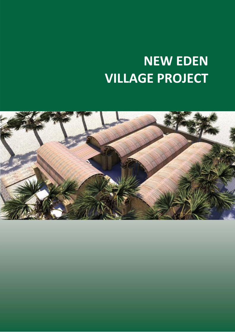
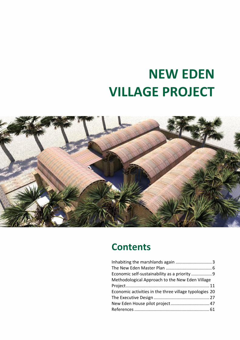
NEW EDEN
VILLAGE PROJECT
NEW EDEN
VILLAGE PROJECT
Contents Inhabiting the marshlands again .............................. 3 The New Eden Master Plan ...................................... 6 Economic self‐sustainability as a priority ................. 9 Methodological Approach to the New Eden Village Project ..................................................................... 11 Economic activities in the three village typologies 20 The Executive Design .............................................. 27 New Eden House pilot project ................................ 47 References .............................................................. 61
3
3
Background
Inhabiting the marshlands again Why human settlements are necessary to bring the Marshlands back to life
The marshes of southern Iraq represent a rare and very early example of an ecosystem where human activities were so integrated and fine‐tuned within the environment that the laws of supply and demand maintained a successful balance. To this extent, serious economic output was constantly produced and sold in terms of fish, dairy products, furniture and other products from reed pulp, to which a variety of other crops and wildlife were harvested by Marsh families.
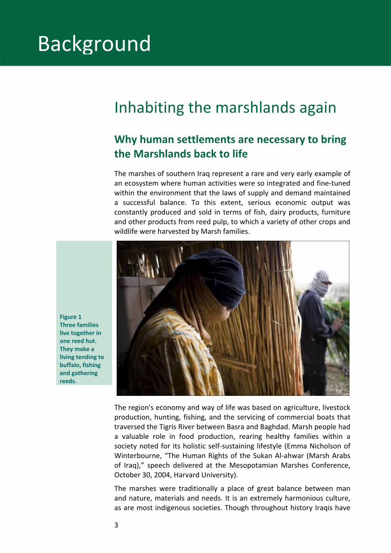
Figure 1 Three families live together in one reed hut. They make a living tending to buffalo, fishing and gathering reeds.
The region's economy and way of life was based on agriculture, livestock production, hunting, fishing, and the servicing of commercial boats that traversed the Tigris River between Basra and Baghdad. Marsh people had a valuable role in food production, rearing healthy families within a society noted for its holistic self‐sustaining lifestyle (Emma Nicholson of Winterbourne, “The Human Rights of the Sukan Al‐ahwar (Marsh Arabs of Iraq),” speech delivered at the Mesopotamian Marshes Conference, October 30, 2004, Harvard University).
The marshes were traditionally a place of great balance between man and nature, materials and needs. It is an extremely harmonious culture, as are most indigenous societies. Though throughout history Iraqis have
4
4
Background
tended to leave rural areas for urban life, people from the marshes have either stayed or opted to return after an absence.
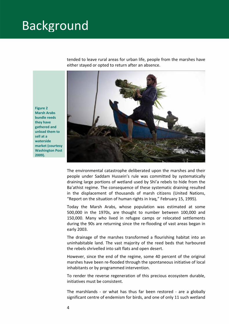
Figure 2 Marsh Arabs bundle reeds they have gathered and unload them to sell at a waterside market (courtesy Washington Post 2009).
The environmental catastrophe deliberated upon the marshes and their people under Saddam Hussein’s rule was committed by systematically draining large portions of wetland used by Shi’a rebels to hide from the Ba’athist regime. The consequence of these systematic draining resulted in the displacement of thousands of marsh citizens (United Nations, “Report on the situation of human rights in Iraq,” February 15, 1995).
Today the Marsh Arabs, whose population was estimated at some 500,000 in the 1970s, are thought to number between 100,000 and 150,000. Many who lived in refugee camps or relocated settlements during the 90s are returning since the re‐flooding of vast areas began in early 2003.
The drainage of the marshes transformed a flourishing habitat into an uninhabitable land. The vast majority of the reed beds that harboured the rebels shrivelled into salt flats and open desert.
However, since the end of the regime, some 40 percent of the original marshes have been re‐flooded through the spontaneous initiative of local inhabitants or by programmed intervention.
To render the reverse regeneration of this precious ecosystem durable, initiatives must be consistent.
The marshlands ‐ or what has thus far been restored ‐ are a globally significant centre of endemism for birds, and one of only 11 such wetland
5
5
Background
centres identified worldwide. The lakes and marshes of lower Mesopotamia were one of the most important wintering areas for migratory waterbirds in western Eurasia (M.I. Evans, excerpt from: “The Iraqi Marshlands: A Human and Environmental Study,” eds. Peter Clark and Sean Magee, the AMAR International Charitable Foundation, 2001).
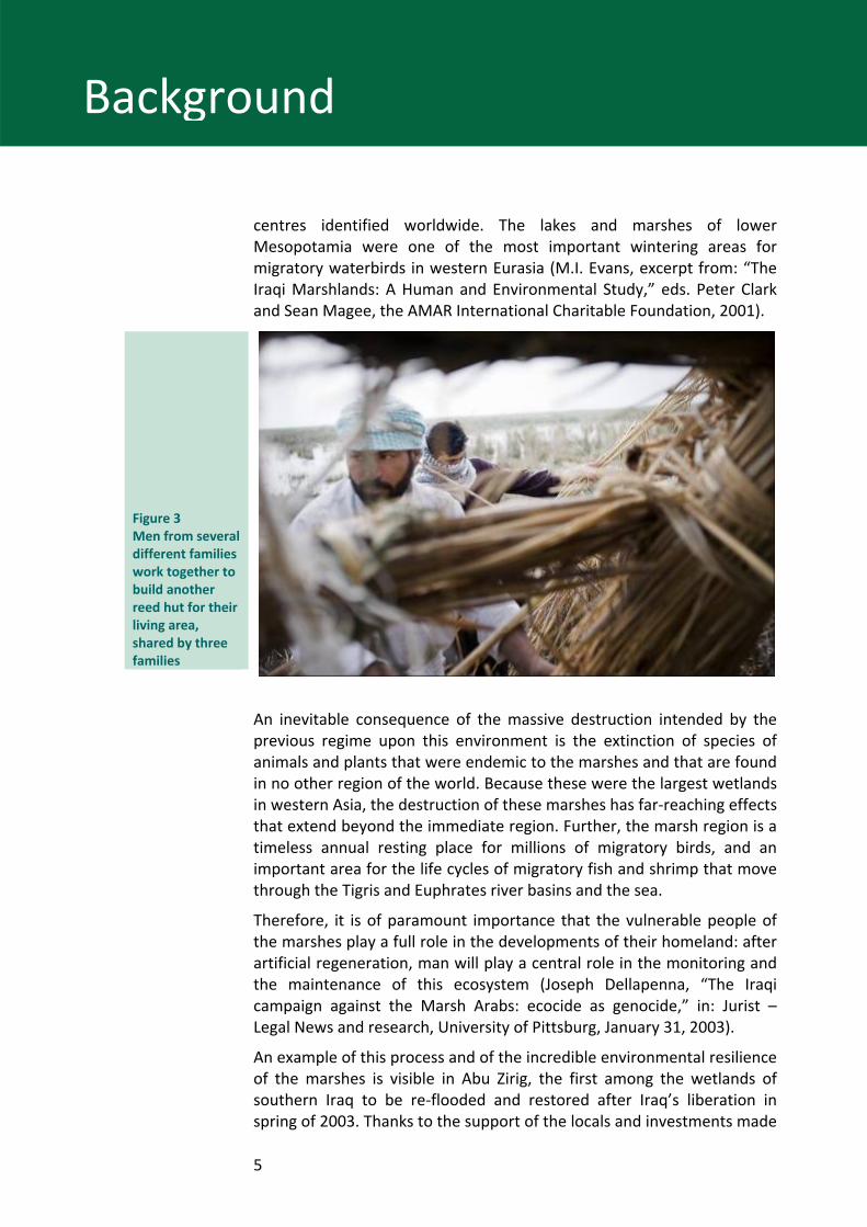
Figure 3 Men from several different families work together to build another reed hut for their living area, shared by three families
An inevitable consequence of the massive destruction intended by the previous regime upon this environment is the extinction of species of animals and plants that were endemic to the marshes and that are found in no other region of the world. Because these were the largest wetlands in western Asia, the destruction of these marshes has far‐reaching effects that extend beyond the immediate region. Further, the marsh region is a timeless annual resting place for millions of migratory birds, and an important area for the life cycles of migratory fish and shrimp that move through the Tigris and Euphrates river basins and the sea.
Therefore, it is of paramount importance that the vulnerable people of the marshes play a full role in the developments of their homeland: after artificial regeneration, man will play a central role in the monitoring and the maintenance of this ecosystem (Joseph Dellapenna, “The Iraqi campaign against the Marsh Arabs: ecocide as genocide,” in: Jurist – Legal News and research, University of Pittsburg, January 31, 2003).
An example of this process and of the incredible environmental resilience of the marshes is visible in Abu Zirig, the first among the wetlands of southern Iraq to be re‐flooded and restored after Iraq’s liberation in spring of 2003. Thanks to the support of the locals and investments made

6
6
Background
throughout a pilot project carried out since June 2003, currently more then 120 square kilometres of the original marsh are a healthy wetland, with reeds growing higher than two metres.
The regenerated marshes provide a great potential for the establishment of permanent wetlands, partly regaining the original rich biodiversity and its stability, where human activities and the ecosystem can flourish together. Indeed, the monitoring of the project has proved the capacity of recovery of the ecosystem from the base of the food web to game, traditionally hunted by marsh dwellers.
In this context, the New Eden Village project has as the main objective to create a renewed, replicable habitative option for the Iraqi Marshlands.
Background of New Eden Village Project Since May 2003, the Italian Ministry for the Environment, Land and Sea Territory (IMELS) has being providing continuous financial and institutional support to the government of Iraq in the difficult endeavour of restoring the marshes of southern Mesopotamia.
This work has been coordinated with the Iraqi Ministries of Environment, Water Resources, and Municipalities and Public Works as well as other donor countries and gave birth to the New Eden Project. The work has been implemented by the New Eden Team, composed by two leading Iraqi NGOs ‐‐ the Free Iraq Foundation (IF) and Nature Iraq (NI) ‐‐ and Italian experts.
In the framework of the New Eden Project, the New Eden Master Plan is one of the most important project finalized, the New Eden Village project, object of the present report, makes stock of the Master Plan’s result, which are summarized up in following pages.
The New Eden Master Plan The purpose of the New Eden Master Plan for Integrated Water Resources Management in the Marshlands Area (hereafter the Plan) is to assist Iraqi Policy Makers by providing sound information and analytical tools with which to make reasoned choices regarding water resource allocation and environmental management decisions. Accordingly, the Plan pursues a holistic and integrated approach to address multiple issues simultaneously. The issues addressed include improvement in water utilization efficiency, environmental restoration, economic enhancement, flood control, and community building for returning peoples.
7
7
Background
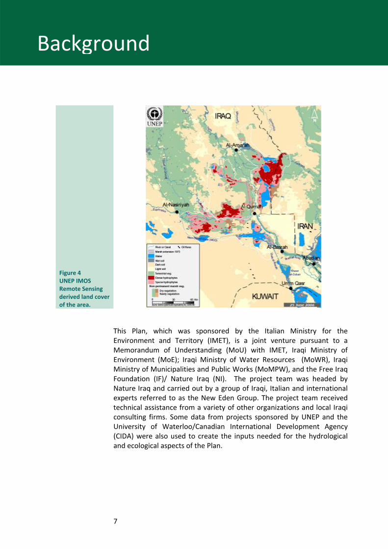
Figure 4 UNEP IMOS Remote Sensing derived land cover of the area.
This Plan, which was sponsored by the Italian Ministry for the Environment and Territory (IMET), is a joint venture pursuant to a Memorandum of Understanding (MoU) with IMET, Iraqi Ministry of Environment (MoE); Iraqi Ministry of Water Resources (MoWR), Iraqi Ministry of Municipalities and Public Works (MoMPW), and the Free Iraq Foundation (IF)/ Nature Iraq (NI). The project team was headed by Nature Iraq and carried out by a group of Iraqi, Italian and international experts referred to as the New Eden Group. The project team received technical assistance from a variety of other organizations and local Iraqi consulting firms. Some data from projects sponsored by UNEP and the University of Waterloo/Canadian International Development Agency (CIDA) were also used to create the inputs needed for the hydrological and ecological aspects of the Plan.
8
8
Background
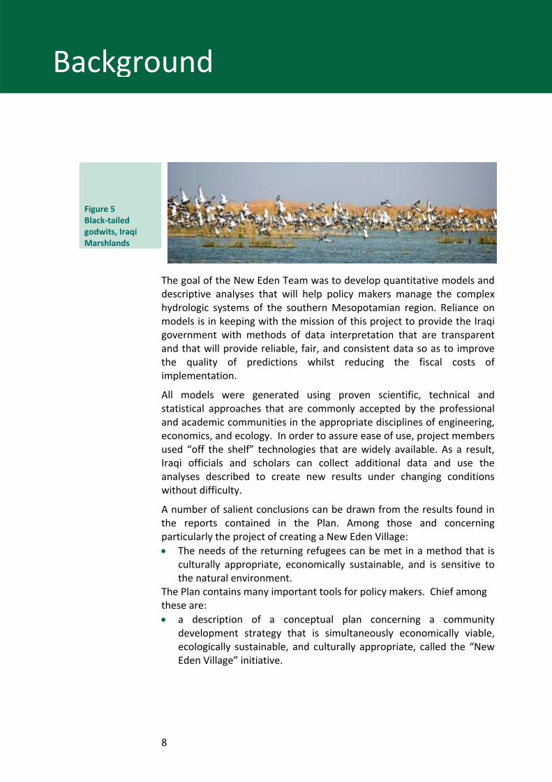
Figure 5 Black‐tailed godwits, Iraqi Marshlands
The goal of the New Eden Team was to develop quantitative models and descriptive analyses that will help policy makers manage the complex hydrologic systems of the southern Mesopotamian region. Reliance on models is in keeping with the mission of this project to provide the Iraqi government with methods of data interpretation that are transparent and that will provide reliable, fair, and consistent data so as to improve the quality of predictions whilst reducing the fiscal costs of implementation.
All models were generated using proven scientific, technical and statistical approaches that are commonly accepted by the professional and academic communities in the appropriate disciplines of engineering, economics, and ecology. In order to assure ease of use, project members used “off the shelf” technologies that are widely available. As a result, Iraqi officials and scholars can collect additional data and use the analyses described to create new results under changing conditions without difficulty.
A number of salient conclusions can be drawn from the results found in the reports contained in the Plan. Among those and concerning particularly the project of creating a New Eden Village: • The needs of the returning refugees can be met in a method that is
culturally appropriate, economically sustainable, and is sensitive to the natural environment.
The Plan contains many important tools for policy makers. Chief among these are: • a description of a conceptual plan concerning a community
development strategy that is simultaneously economically viable, ecologically sustainable, and culturally appropriate, called the “New Eden Village” initiative.
9
New Eden Village‐Feasibility Study
Economic self‐sustainability as a priority
Realization scenarios
Economic self‐sustainability was the priority of the New Eden Village Feasibility Study, released in 2006. It represents the number one scenario for the life of the settlements, doubtless long‐term, as infrastructure bridges the actual gap for longevity in the area to trigger large‐scale development.
As mentioned above, this is the reason the project delivers accurate indications on resource allocation, and why the project is fine tuned to include environmental instances that played such an important role in the area’s economy as its thriving past has revealed. If the final goal is to help regenerate the regional economic system as a whole, then planning must abide by a high degree of self‐sustainability, since the start‐up phase.
That said, self‐sustainability has shaped all aspects of the project, at each scale of planning. Resumption of traditional building techniques for housing, for example, has implications far beyond the creation of a pleasant environment, an instance that is at least under consideration, and that is earmarked of high importance. Case in point, the slump in cane handicraft production, subsequent to the curtailment in reed growth due to the drainage of large portions of marsh, has meant the loss of traditional professional skills that once strongly contributed to the dwellers’ economy, the very example of a circumstance the Feasibility Study intends to reverse.
On a larger scale, the Feasibility Study has identified various types of resources wholly capable of playing a role in economic regeneration. Landscape, the environment and culture of each place that includes knowledge and expertise of local people are acknowledged as mainstays with strategic potential. New Eden Village has built its rationale around a holistic combination derived from thorough research of the history of the region taking into account its past and future potential.
New Eden Villages includes a broad overall strategy for the region with the possibility of realizing divisions and phases for flexibility in accordance with the needs and opportunities that arise periodically within any given area.
10
New Eden Village‐Feasibility Study
Public utilities and network services are provided to settlements with minor differences in technique that in some way engulf customary support from village to village. In the meantime, returning populations can supply the workforce for ongoing construction. The area’s economy can slowly shift from self‐sustainability to income generation and then begin to broaden its base, with plans for varying types of “New Eden Villages” constructed in areas across the planned strip.
In a long‐term scenario, a post‐war reconstruction would result in vast infrastructures at the regional scale, and if already re‐developed, nearby areas that included a system of New Eden Villages, might make the most of proximity to lines of communication.
As above‐mentioned, the overall scheme is blueprinted as highly flexible and suitable throughout the strip, particularly taking into account favourable conditions within a given area designated as an ideal location to build a village.
For this reason, New Eden Villages are considered a model for future housing, a feasible project, and a tool for definition of priorities with respect to infrastructure and resource allocation that can be implemented in stages of various operational phases, beginning with the construction of a single village.
Each type of village can then be realized independent of the proposed settlement system, yet within the working system, allowing for changes in the future and for individual perspectives.
Despite the idea for constructive autonomy amid a fledging system, consideration of a decision‐making process aimed at defining priorities and setting rules for a pilot settlement is immediately attainable.
11
New Eden Village‐Feasibility Study
Methodological Approach to the New Eden Village Project
Methodology and territorial organization To accomplish the complex task to recreate such an environment, an interdisciplinary approach is required that includes expertise in ecological restoration, with knowledge of the traditional way of life in the marshes, and with modern technologies available to accommodate the needs and desires of today’s dwellers.
Engineers, ecologists, and ethnologists together with land planners and architects bring a collective expertise to the common table to develop a sustainable and thriving human and ecological environment. This provides a tremendous opportunity to restore not only an ecosystem, but to build a sustainable lifestyle that matches the best of the past and the present.
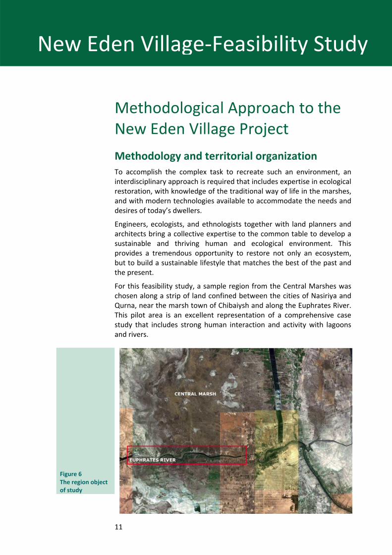
For this feasibility study, a sample region from the Central Marshes was chosen along a strip of land confined between the cities of Nasiriya and Qurna, near the marsh town of Chibaiysh and along the Euphrates River. This pilot area is an excellent representation of a comprehensive case study that includes strong human interaction and activity with lagoons and rivers.
Figure 6 The region object of study
12
New Eden Village‐Feasibility Study
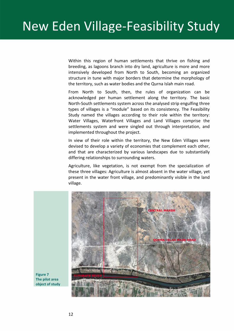
Within this region of human settlements that thrive on fishing and breeding, as lagoons branch into dry land, agriculture is more and more intensively developed from North to South, becoming an organized structure in tune with major borders that determine the morphology of the territory, such as water bodies and the Qurna Islah main road.
From North to South, then, the rules of organization can be acknowledged per human settlement along the territory. The basic North‐South settlements system across the analysed strip engulfing three types of villages is a “module” based on its consistency. The Feasibility Study named the villages according to their role within the territory: Water Villages, Waterfront Villages and Land Villages comprise the settlements system and were singled out through interpretation, and implemented throughout the project.
In view of their role within the territory, the New Eden Villages were devised to develop a variety of economies that complement each other, and that are characterized by various landscapes due to substantially differing relationships to surrounding waters.
Agriculture, like vegetation, is not exempt from the specialization of these three villages: Agriculture is almost absent in the water village, yet present in the water front village, and predominantly visible in the land village.
Figure 7 The pilot area object of study
13
New Eden Village‐Feasibility Study
Created for a complex territory, and born of its interpretation, the basic module of the three settlements is devised to fit into and implement the territory that it originates from.
As any patterned structure, this scheme can be modified and applied elsewhere in the region, beyond the strip.
Thus, the project’s structure is derived through thorough study and an understanding of the territory and its organization, choosing existing resources and structuring them within accommodating systems.
This process was only possible through the use of remote sensing techniques.
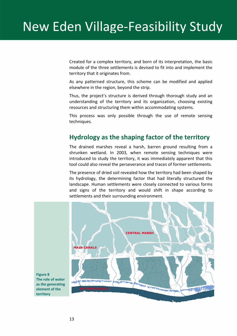
Hydrology as the shaping factor of the territory The drained marshes reveal a harsh, barren ground resulting from a shrunken wetland. In 2003, when remote sensing techniques were introduced to study the territory, it was immediately apparent that this tool could also reveal the perseverance and traces of former settlements.
The presence of dried soil revealed how the territory had been shaped by its hydrology, the determining factor that had literally structured the landscape. Human settlements were closely connected to various forms and signs of the territory and would shift in shape according to settlements and their surrounding environment.
Figure 8 The role of water as the generating element of the territory
14
New Eden Village‐Feasibility Study
Significant modifications could also be ascribed to manmade structural changes such as road construction. Indeed, given the same territorial conditions, the images reveal the repetition of such settlement systems running from north to south, which share strong features of similitude in their structure.
Utterly pervasive throughout the region, water is the element that has literally determined the nature of these lands and cannot be dispensed with when devising any future development. Water represents more than just a system. Water bodies have shaped and strongly characterize this territory: The Euphrates river, canals connecting the river to the Central Marsh, internal lagoons between the river and the main road linking Basra to Nasiriya and the Central Marsh.
Presently, the marshes can no longer function as in the past, when large floods created the necessary hydro‐period that made biodiversity possible in these regions. Today, a complex system of dams and reservoirs exercise a complete level of control from what was once a natural system. New Eden Villages could be a successful example of the socio‐economical re‐birth of these regions, but only if water is carefully managed. To this extent, a number of large civil‐engineering structures have been studied and proposed within the New Eden Master Plan. Such structures have been designed to manage available water and re‐produce the natural cycle of water expanding and retreating over the marshlands, where water levels inside canals and inner lagoons have considerably changed over time.
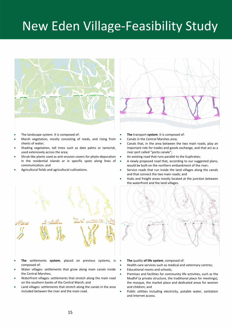
Systems defining the territory The territory within the study area is organized into four main systems described as follows: • The landscape system; • The transport system • The settlements system • The quality of life system.
15
New Eden Village‐Feasibility Study
• The landscape system. It is composed of: • Marsh vegetation, mostly consisting of reeds, and rising from
sheets of water; • Shading vegetation, tall trees such as date palms or tamerisk,
used extensively across the area; • Shrub‐like plants used as anti‐erosion covers for phyto‐depuration
in the residential islands or in specific spots along lines of communication; and
• Agricultural fields and agricultural cultivations.
• The transport system. It is composed of: • Canals in the Central Marshes area; • Canals that, in the area between the two main roads, play an
important role for trades and goods exchange, and that act as a river port called “porto canale”;
• An existing road that runs parallel to the Euphrates; • A newly proposed road that, according to our suggested plans,
would be built on the northern embankment of the river; • Service roads that run inside the land villages along the canals
and that connect the two main roads; and • Hubs and freight areas mostly located at the junction between
the waterfront and the land villages.
• The settlements system, placed on previous systems, is composed of:
• Water villages: settlements that grow along main canals inside the Central Marshes;
• Waterfront villages: settlements that stretch along the main road on the southern banks of the Central Marsh; and
• Land villages: settlements that stretch along the canals in the area included between the river and the main road.
• The quality of life system, composed of: • Health‐care services such as medical and veterinary centres; • Educational rooms and schools; • Premises and facilities for community life activities, such as the
Mudhif (a private structure, the traditional place for meetings), the mosque, the market place and dedicated areas for women and children; and
• Public utilities including electricity, potable water, sanitation and Internet access.
16
New Eden Village‐Feasibility Study
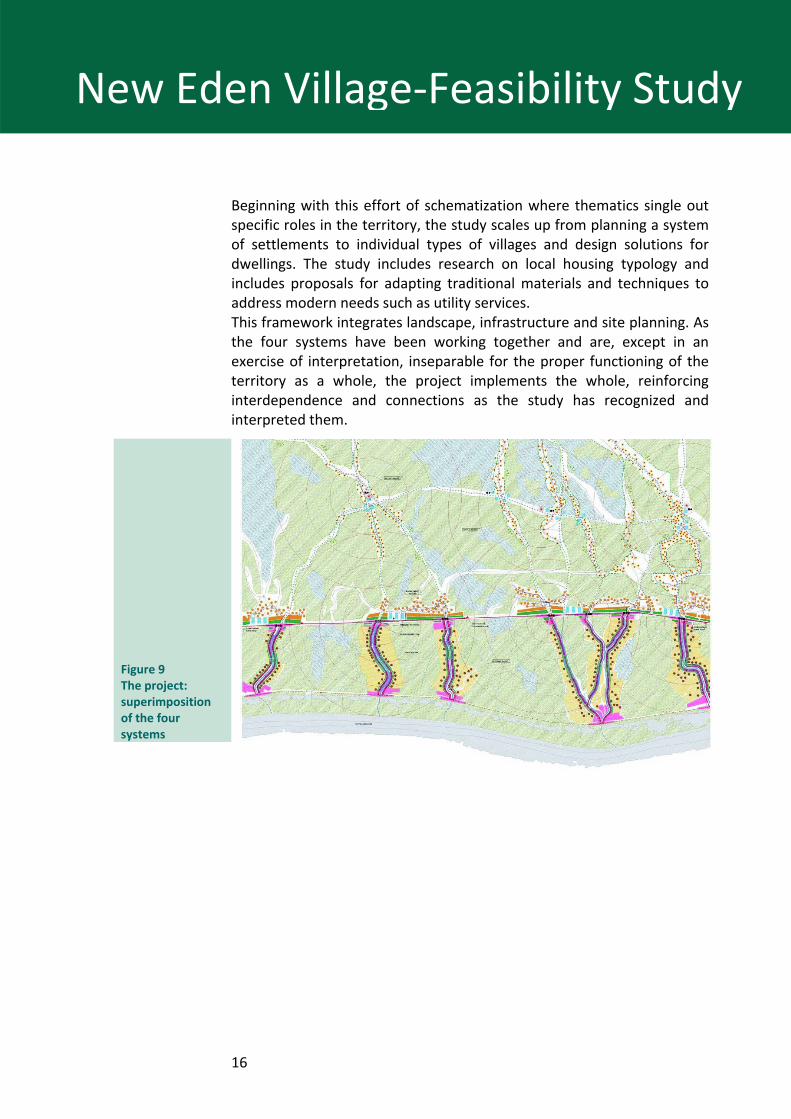
Beginning with this effort of schematization where thematics single out specific roles in the territory, the study scales up from planning a system of settlements to individual types of villages and design solutions for dwellings. The study includes research on local housing typology and includes proposals for adapting traditional materials and techniques to address modern needs such as utility services. This framework integrates landscape, infrastructure and site planning. As the four systems have been working together and are, except in an exercise of interpretation, inseparable for the proper functioning of the territory as a whole, the project implements the whole, reinforcing interdependence and connections as the study has recognized and interpreted them.
Figure 9 The project: superimposition of the four systems
17
New Eden Village‐Feasibility Study
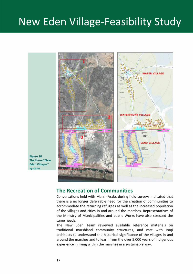
Figure 10 The three “New Eden Villages” systems
The Recreation of Communities Conversations held with Marsh Arabs during field surveys indicated that there is a no longer deferrable need for the creation of communities to accommodate the returning refugees as well as the increased population of the villages and cities in and around the marshes. Representatives of the Ministry of Municipalities and public Works have also stressed the same needs. The New Eden Team reviewed available reference materials on traditional marshland community structures, and met with Iraqi architects to understand the historical significance of the villages in and around the marshes and to learn from the over 5,000 years of indigenous experience in living within the marshes in a sustainable way.
18
New Eden Village‐Feasibility Study
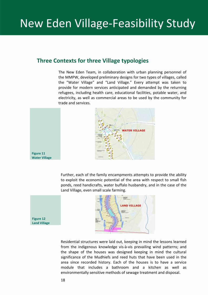
Three Contexts for three Village typologies
The New Eden Team, in collaboration with urban planning personnel of the MMPW, developed preliminary designs for two types of villages, called the “Water Village” and “Land Village.” Every attempt was taken to provide for modern services anticipated and demanded by the returning refugees, including health care, educational facilities, potable water, and electricity, as well as commercial areas to be used by the community for trade and services.
Figure 11 Water Village
Further, each of the family encampments attempts to provide the ability to exploit the economic potential of the area with respect to small fish ponds, reed handicrafts, water buffalo husbandry, and in the case of the Land Village, even small scale farming.
Figure 12 Land Village
Residential structures were laid out, keeping in mind the lessons learned from the indigenous knowledge vis‐à‐vis prevailing wind patterns; and the shape of the houses was designed keeping in mind the cultural significance of the Mudhiefs and reed huts that have been used in the area since recorded history. Each of the houses is to have a service module that includes a bathroom and a kitchen as well as environmentally sensitive methods of sewage treatment and disposal.
19
New Eden Village‐Feasibility Study
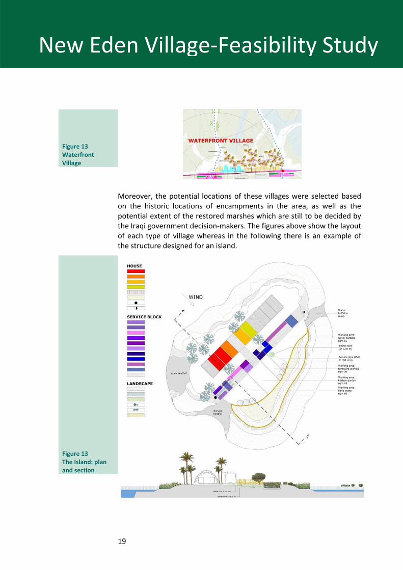
Figure 13 Waterfront Village
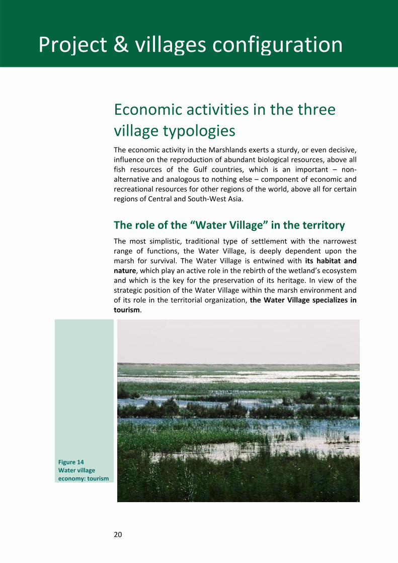
Moreover, the potential locations of these villages were selected based on the historic locations of encampments in the area, as well as the potential extent of the restored marshes which are still to be decided by the Iraqi government decision‐makers. The figures above show the layout of each type of village whereas in the following there is an example of the structure designed for an island.
Figure 13 The Island: plan and section
20
Project & villages configuration
Economic activities in the three village typologies The economic activity in the Marshlands exerts a sturdy, or even decisive, influence on the reproduction of abundant biological resources, above all fish resources of the Gulf countries, which is an important – non‐alternative and analogous to nothing else – component of economic and recreational resources for other regions of the world, above all for certain regions of Central and South‐West Asia.
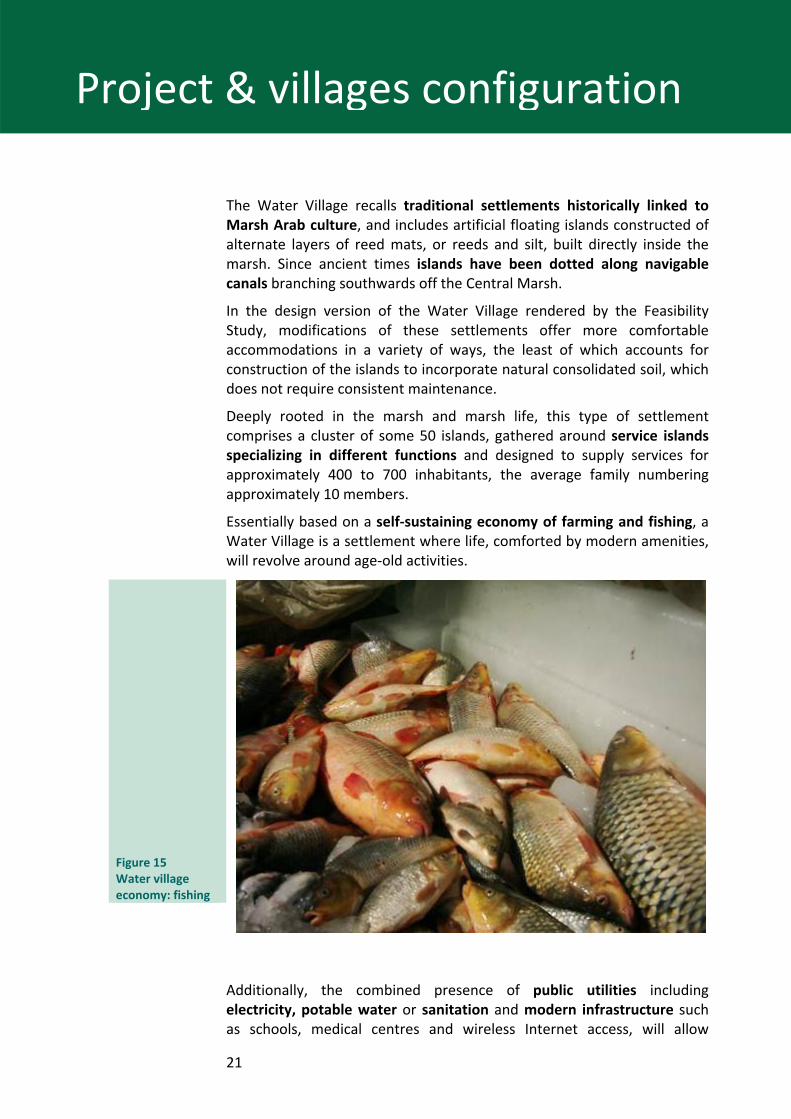
The role of the “Water Village” in the territory The most simplistic, traditional type of settlement with the narrowest range of functions, the Water Village, is deeply dependent upon the marsh for survival. The Water Village is entwined with its habitat and nature, which play an active role in the rebirth of the wetland’s ecosystem and which is the key for the preservation of its heritage. In view of the strategic position of the Water Village within the marsh environment and of its role in the territorial organization, the Water Village specializes in tourism.
Figure 14 Water village economy: tourism
21
Project & villages configuration
The Water Village recalls traditional settlements historically linked to Marsh Arab culture, and includes artificial floating islands constructed of alternate layers of reed mats, or reeds and silt, built directly inside the marsh. Since ancient times islands have been dotted along navigable canals branching southwards off the Central Marsh.
In the design version of the Water Village rendered by the Feasibility Study, modifications of these settlements offer more comfortable accommodations in a variety of ways, the least of which accounts for construction of the islands to incorporate natural consolidated soil, which does not require consistent maintenance.
Deeply rooted in the marsh and marsh life, this type of settlement comprises a cluster of some 50 islands, gathered around service islands specializing in different functions and designed to supply services for approximately 400 to 700 inhabitants, the average family numbering approximately 10 members.
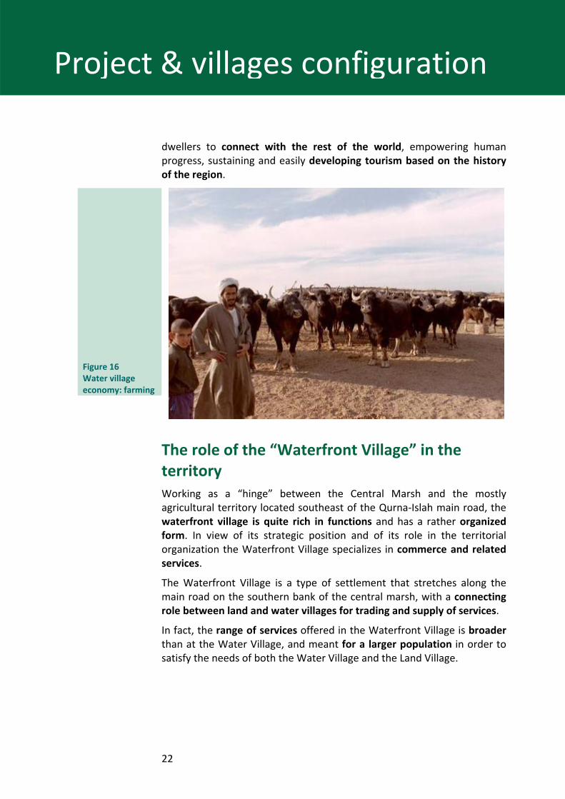
Essentially based on a self‐sustaining economy of farming and fishing, a Water Village is a settlement where life, comforted by modern amenities, will revolve around age‐old activities.
Figure 15 Water village economy: fishing
Additionally, the combined presence of public utilities including electricity, potable water or sanitation and modern infrastructure such as schools, medical centres and wireless Internet access, will allow
22
Project & villages configuration
dwellers to connect with the rest of the world, empowering human progress, sustaining and easily developing tourism based on the history of the region.
Figure 16 Water village economy: farming
The role of the “Waterfront Village” in the territory Working as a “hinge” between the Central Marsh and the mostly agricultural territory located southeast of the Qurna‐Islah main road, the waterfront village is quite rich in functions and has a rather organized form. In view of its strategic position and of its role in the territorial organization the Waterfront Village specializes in commerce and related services.
The Waterfront Village is a type of settlement that stretches along the main road on the southern bank of the central marsh, with a connecting role between land and water villages for trading and supply of services.
In fact, the range of services offered in the Waterfront Village is broader than at the Water Village, and meant for a larger population in order to satisfy the needs of both the Water Village and the Land Village.
23
Project & villages configuration
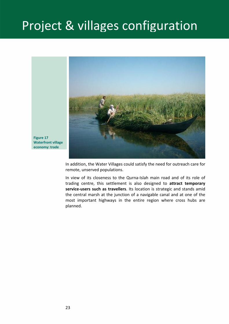
Figure 17 Waterfront village economy: trade
In addition, the Water Villages could satisfy the need for outreach care for remote, unserved populations.
In view of its closeness to the Qurna‐Islah main road and of its role of trading centre, this settlement is also designed to attract temporary service‐users such as travellers. Its location is strategic and stands amid the central marsh at the junction of a navigable canal and at one of the most important highways in the entire region where cross hubs are planned.
24
Project & villages configuration
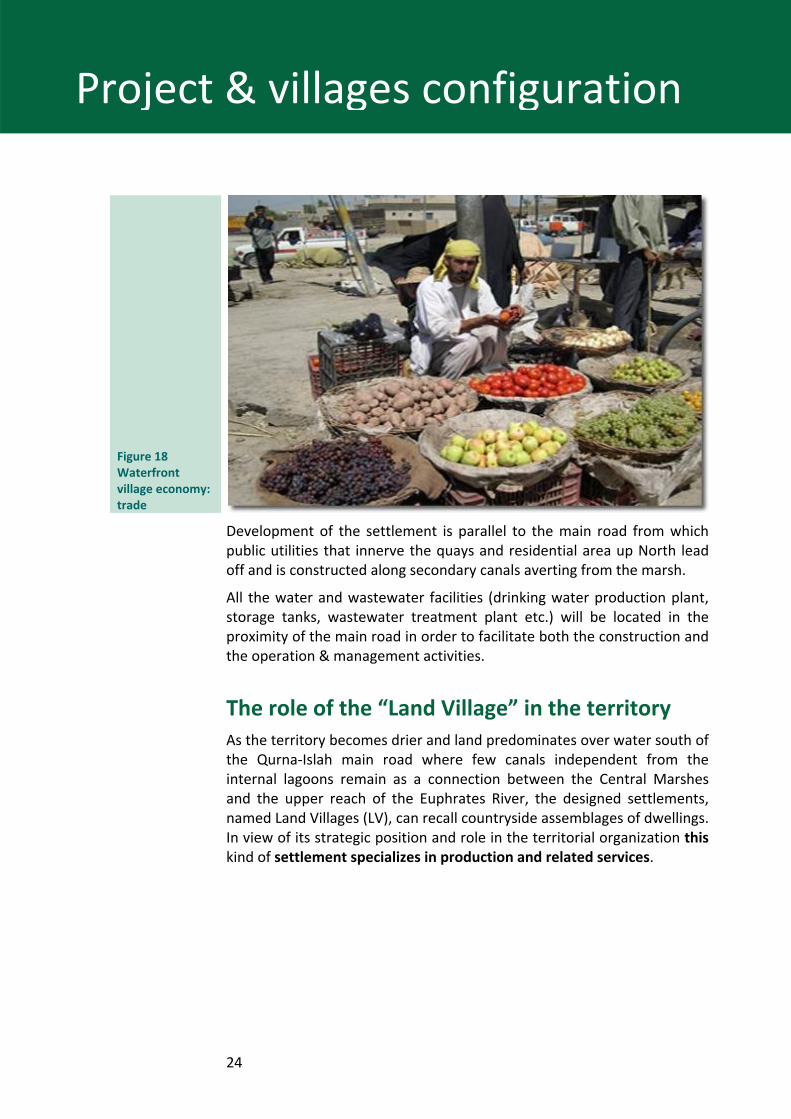
Figure 18 Waterfront village economy: trade
Development of the settlement is parallel to the main road from which public utilities that innerve the quays and residential area up North lead off and is constructed along secondary canals averting from the marsh.
All the water and wastewater facilities (drinking water production plant, storage tanks, wastewater treatment plant etc.) will be located in the proximity of the main road in order to facilitate both the construction and the operation & management activities.
The role of the “Land Village” in the territory As the territory becomes drier and land predominates over water south of the Qurna‐Islah main road where few canals independent from the internal lagoons remain as a connection between the Central Marshes and the upper reach of the Euphrates River, the designed settlements, named Land Villages (LV), can recall countryside assemblages of dwellings. In view of its strategic position and role in the territorial organization this kind of settlement specializes in production and related services.
25
Project & villages configuration
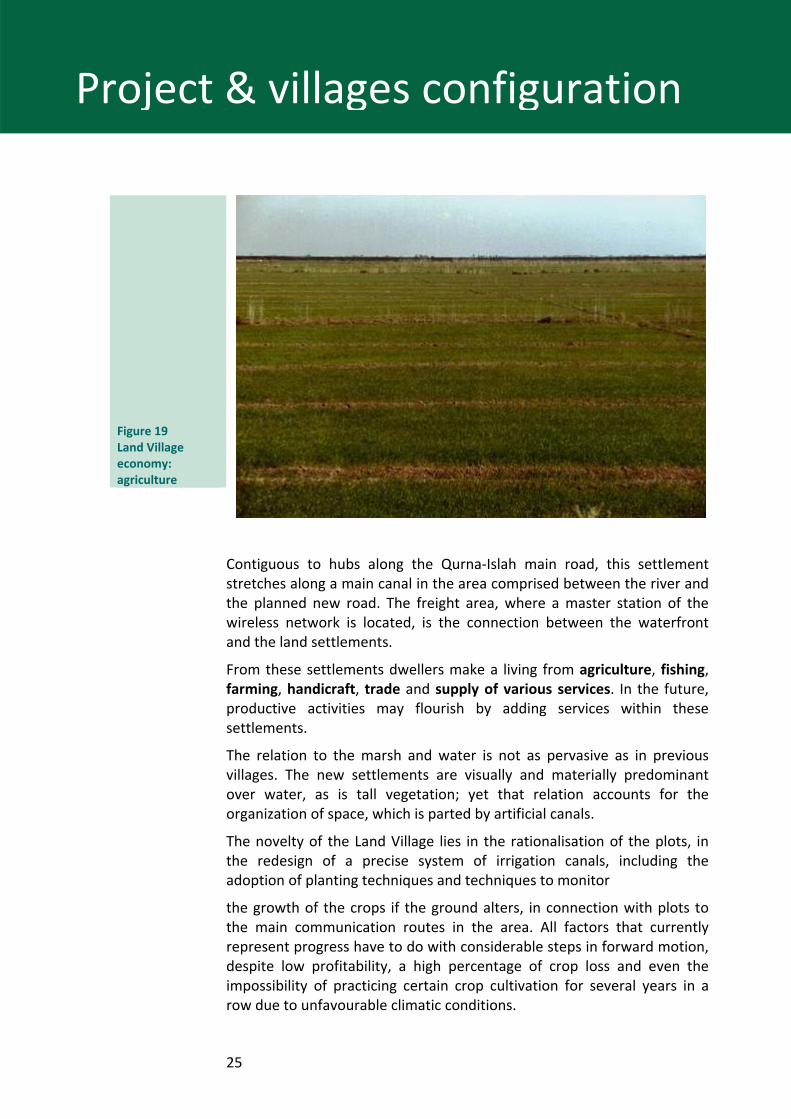
Figure 19 Land Village economy: agriculture
Contiguous to hubs along the Qurna‐Islah main road, this settlement stretches along a main canal in the area comprised between the river and the planned new road. The freight area, where a master station of the wireless network is located, is the connection between the waterfront and the land settlements.
From these settlements dwellers make a living from agriculture, fishing, farming, handicraft, trade and supply of various services. In the future, productive activities may flourish by adding services within these settlements.
The relation to the marsh and water is not as pervasive as in previous villages. The new settlements are visually and materially predominant over water, as is tall vegetation; yet that relation accounts for the organization of space, which is parted by artificial canals.
The novelty of the Land Village lies in the rationalisation of the plots, in the redesign of a precise system of irrigation canals, including the adoption of planting techniques and techniques to monitor
the growth of the crops if the ground alters, in connection with plots to the main communication routes in the area. All factors that currently represent progress have to do with considerable steps in forward motion, despite low profitability, a high percentage of crop loss and even the impossibility of practicing certain crop cultivation for several years in a row due to unfavourable climatic conditions.
26
Project & villages configuration
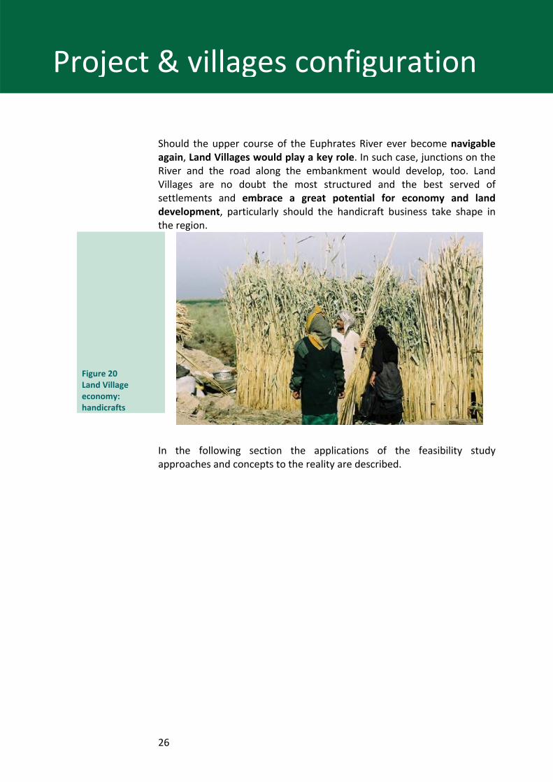
Should the upper course of the Euphrates River ever become navigable again, Land Villages would play a key role. In such case, junctions on the River and the road along the embankment would develop, too. Land Villages are no doubt the most structured and the best served of settlements and embrace a great potential for economy and land development, particularly should the handicraft business take shape in the region.
Figure 20 Land Village economy: handicrafts
In the following section the applications of the feasibility study approaches and concepts to the reality are described.
27
New Eden Village‐ The Project
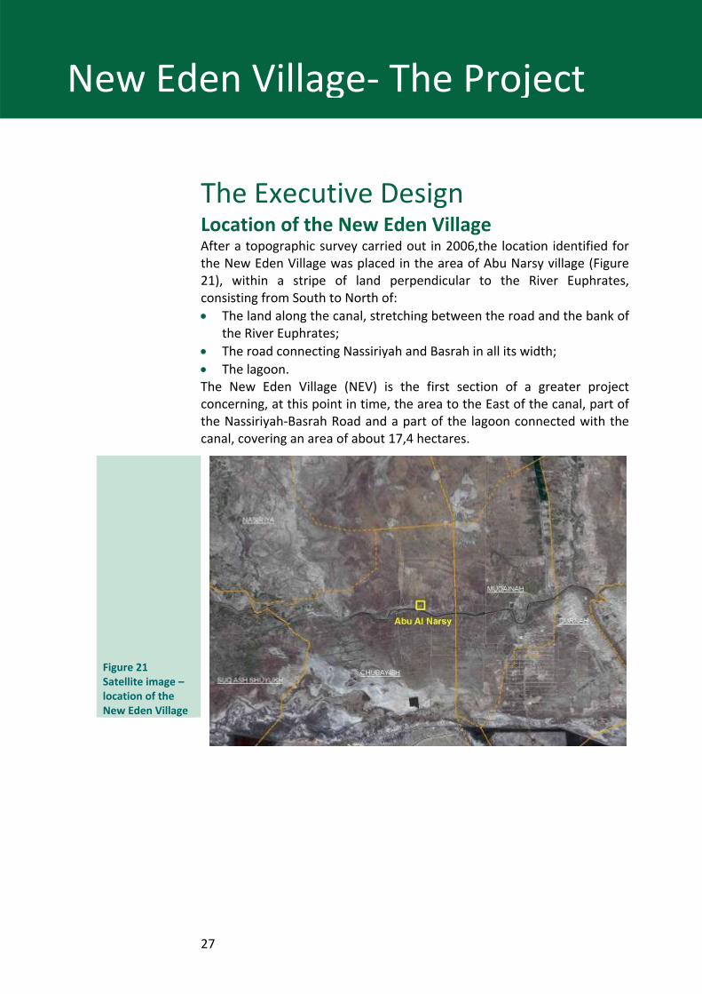
The Executive Design Location of the New Eden Village After a topographic survey carried out in 2006,the location identified for the New Eden Village was placed in the area of Abu Narsy village (Figure 21), within a stripe of land perpendicular to the River Euphrates, consisting from South to North of: • The land along the canal, stretching between the road and the bank of
the River Euphrates; • The road connecting Nassiriyah and Basrah in all its width; • The lagoon. The New Eden Village (NEV) is the first section of a greater project concerning, at this point in time, the area to the East of the canal, part of the Nassiriyah‐Basrah Road and a part of the lagoon connected with the canal, covering an area of about 17,4 hectares.
Figure 21 Satellite image – location of the New Eden Village
28
New Eden Village‐ The Project
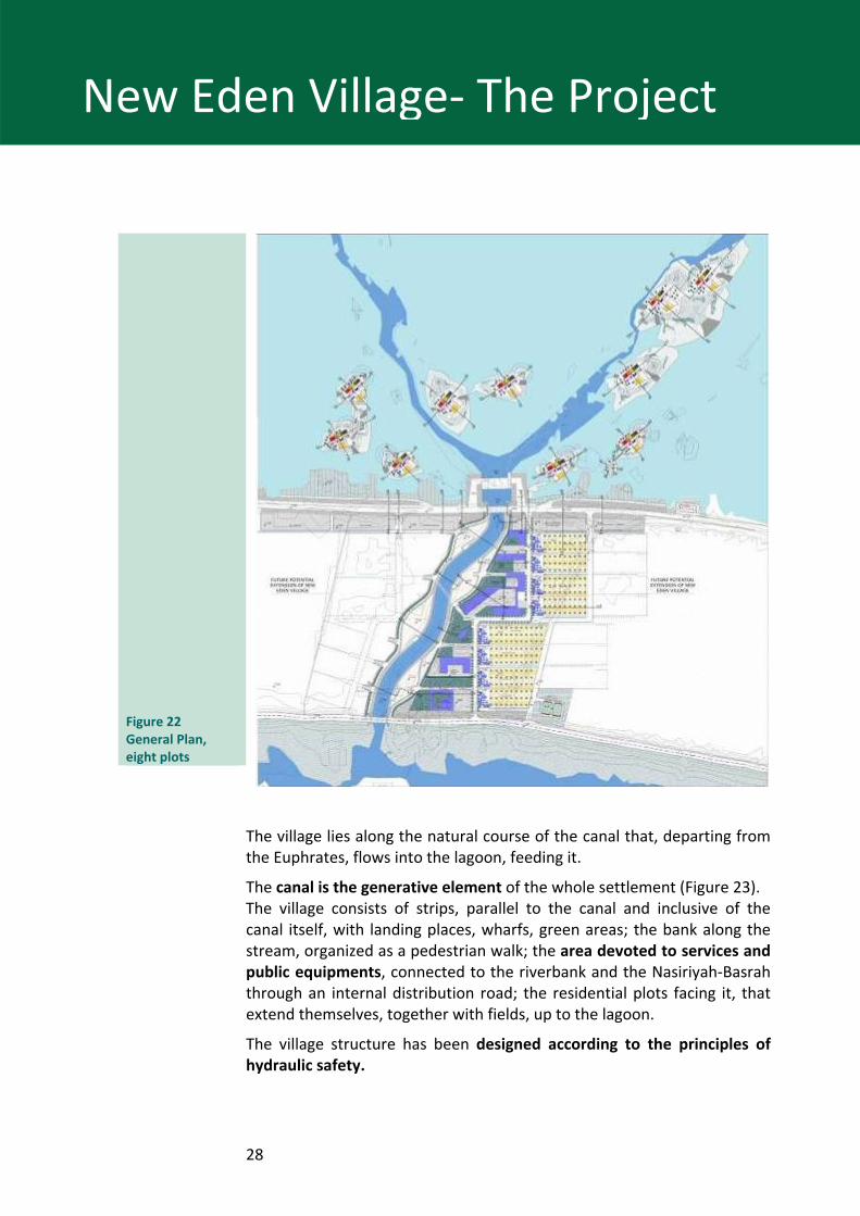
Figure 22 General Plan, eight plots
The village lies along the natural course of the canal that, departing from the Euphrates, flows into the lagoon, feeding it.
The canal is the generative element of the whole settlement (Figure 23). The village consists of strips, parallel to the canal and inclusive of the canal itself, with landing places, wharfs, green areas; the bank along the stream, organized as a pedestrian walk; the area devoted to services and public equipments, connected to the riverbank and the Nasiriyah‐Basrah through an internal distribution road; the residential plots facing it, that extend themselves, together with fields, up to the lagoon.
The village structure has been designed according to the principles of hydraulic safety.
29
New Eden Village‐ The Project
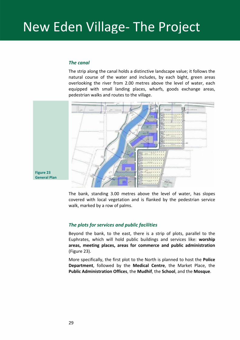
The canal
The strip along the canal holds a distinctive landscape value; it follows the natural course of the water and includes, by each bight, green areas overlooking the river from 2.00 metres above the level of water, each equipped with small landing places, wharfs, goods exchange areas, pedestrian walks and routes to the village.
Figure 23 General Plan
The bank, standing 3.00 metres above the level of water, has slopes covered with local vegetation and is flanked by the pedestrian service walk, marked by a row of palms.
The plots for services and public facilities
Beyond the bank, to the east, there is a strip of plots, parallel to the Euphrates, which will hold public buildings and services like: worship areas, meeting places, areas for commerce and public administration (Figure 23).
More specifically, the first plot to the North is planned to host the Police Department, followed by the Medical Centre, the Market Place, the Public Administration Offices, the Mudhif, the School, and the Mosque.
30
New Eden Village‐ The Project
Figure 24 Services – Land lots for Public facilities
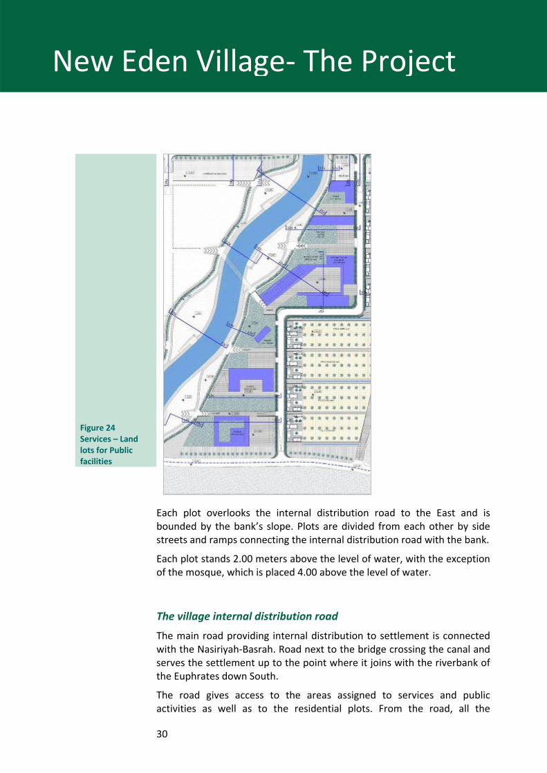
Each plot overlooks the internal distribution road to the East and is bounded by the bank’s slope. Plots are divided from each other by side streets and ramps connecting the internal distribution road with the bank.
Each plot stands 2.00 meters above the level of water, with the exception of the mosque, which is placed 4.00 above the level of water.
The village internal distribution road
The main road providing internal distribution to settlement is connected with the Nasiriyah‐Basrah. Road next to the bridge crossing the canal and serves the settlement up to the point where it joins with the riverbank of the Euphrates down South.
The road gives access to the areas assigned to services and public activities as well as to the residential plots. From the road, all the
31
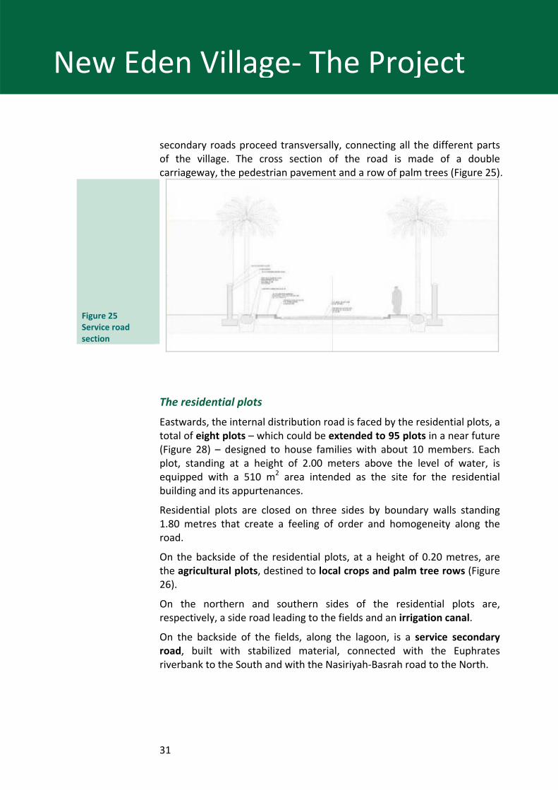
New Eden Village‐ The Project
secondary roads proceed transversally, connecting all the different parts of the village. The cross section of the road is made of a double carriageway, the pedestrian pavement and a row of palm trees (Figure 25).
Figure 25 Service road section
The residential plots
Eastwards, the internal distribution road is faced by the residential plots, a total of eight plots – which could be extended to 95 plots in a near future (Figure 28) – designed to house families with about 10 members. Each plot, standing at a height of 2.00 meters above the level of water, is equipped with a 510 m2 area intended as the site for the residential building and its appurtenances.
Residential plots are closed on three sides by boundary walls standing 1.80 metres that create a feeling of order and homogeneity along the road.
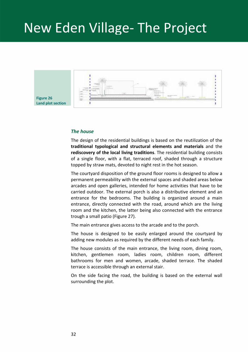
On the backside of the residential plots, at a height of 0.20 metres, are the agricultural plots, destined to local crops and palm tree rows (Figure 26).
On the northern and southern sides of the residential plots are, respectively, a side road leading to the fields and an irrigation canal.
On the backside of the fields, along the lagoon, is a service secondary road, built with stabilized material, connected with the Euphrates riverbank to the South and with the Nasiriyah‐Basrah road to the North.
32
New Eden Village‐ The Project
Figure 26 Land plot section
The house
The design of the residential buildings is based on the reutilization of the traditional typological and structural elements and materials and the rediscovery of the local living traditions. The residential building consists of a single floor, with a flat, terraced roof, shaded through a structure topped by straw mats, devoted to night rest in the hot season.
The courtyard disposition of the ground floor rooms is designed to allow a permanent permeability with the external spaces and shaded areas below arcades and open galleries, intended for home activities that have to be carried outdoor. The external porch is also a distributive element and an entrance for the bedrooms. The building is organized around a main entrance, directly connected with the road, around which are the living room and the kitchen, the latter being also connected with the entrance trough a small patio (Figure 27).
The main entrance gives access to the arcade and to the porch.
The house is designed to be easily enlarged around the courtyard by adding new modules as required by the different needs of each family.
The house consists of the main entrance, the living room, dining room, kitchen, gentlemen room, ladies room, children room, different bathrooms for men and women, arcade, shaded terrace. The shaded terrace is accessible through an external stair.
On the side facing the road, the building is based on the external wall surrounding the plot.
33
New Eden Village‐ The Project
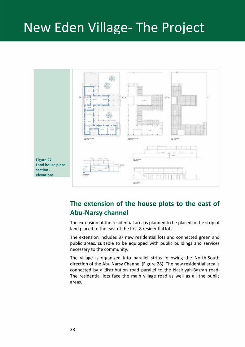
Figure 27 Land house plans ‐section ‐ elevations
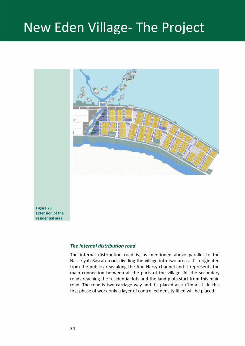
The extension of the house plots to the east of Abu‐Narsy channel The extension of the residential area is planned to be placed in the strip of land placed to the east of the first 8 residential lots.
The extension includes 87 new residential lots and connected green and public areas, suitable to be equipped with public buildings and services necessary to the community.
The village is organized into parallel strips following the North‐South direction of the Abu Narsy Channel (Figure 28). The new residential area is connected by a distribution road parallel to the Nasiriyah‐Basrah road. The residential lots face the main village road as well as all the public areas.
34
New Eden Village‐ The Project
Figure 28 Extension of the residential area
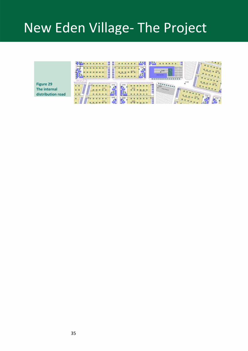
The internal distribution road
The internal distribution road is, as mentioned above parallel to the Nassiriyah‐Basrah road, dividing the village into two areas. It’s originated from the public areas along the Abu Narsy channel and it represents the main connection between all the parts of the village. All the secondary roads reaching the residential lots and the land plots start from this main road. The road is two‐carriage way and it’s placed at a +1m a.s.l.. In this first phase of work only a layer of controlled density filled will be placed.
35
New Eden Village‐ The Project
Figure 29 The internal distribution road
36
New Eden Village‐ The Project
The residential lots
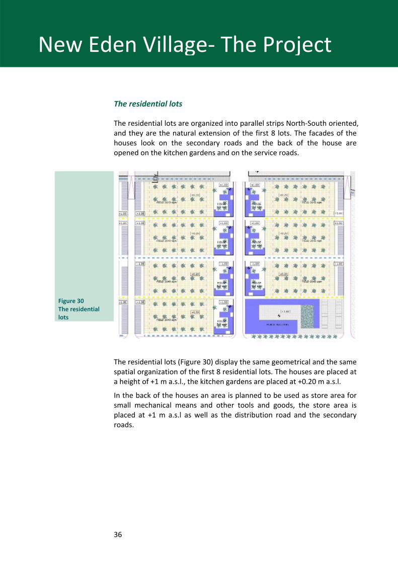
The residential lots are organized into parallel strips North‐South oriented, and they are the natural extension of the first 8 lots. The facades of the houses look on the secondary roads and the back of the house are opened on the kitchen gardens and on the service roads.
Figure 30 The residential lots
The residential lots (Figure 30) display the same geometrical and the same spatial organization of the first 8 residential lots. The houses are placed at a height of +1 m a.s.l., the kitchen gardens are placed at +0.20 m a.s.l.
In the back of the houses an area is planned to be used as store area for small mechanical means and other tools and goods, the store area is placed at +1 m a.s.l as well as the distribution road and the secondary roads.
37
New Eden Village‐ The Project
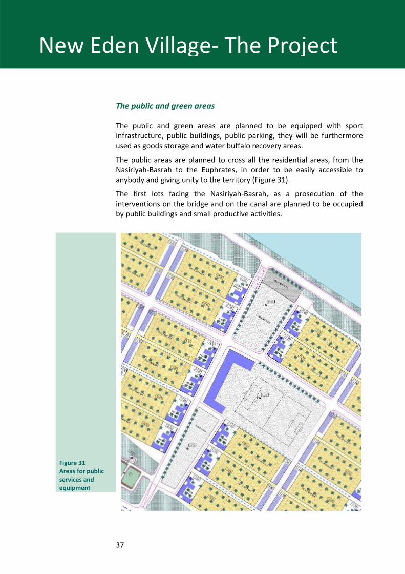
The public and green areas
The public and green areas are planned to be equipped with sport infrastructure, public buildings, public parking, they will be furthermore used as goods storage and water buffalo recovery areas.
The public areas are planned to cross all the residential areas, from the Nasiriyah‐Basrah to the Euphrates, in order to be easily accessible to anybody and giving unity to the territory (Figure 31).
The first lots facing the Nasiriyah‐Basrah, as a prosecution of the interventions on the bridge and on the canal are planned to be occupied by public buildings and small productive activities.
Figure 31 Areas for public services and equipment
38
New Eden Village‐ The Project
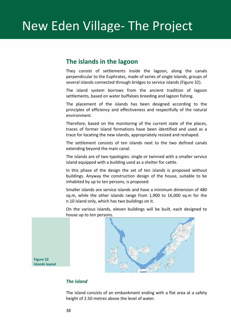
The islands in the lagoon They consist of settlements inside the lagoon, along the canals perpendicular to the Euphrates, made of series of single islands, groups of several islands connected through bridges to service islands (Figure 32).
The island system borrows from the ancient tradition of lagoon settlements, based on water buffaloes breeding and lagoon fishing.
The placement of the islands has been designed according to the principles of efficiency and effectiveness and respectfully of the natural environment.
Therefore, based on the monitoring of the current state of the places, traces of former island formations have been identified and used as a trace for locating the new islands, appropriately resized and reshaped.
The settlement consists of ten islands next to the two defined canals extending beyond the main canal.
The islands are of two typologies: single or twinned with a smaller service island equipped with a building used as a shelter for cattle.
In this phase of the design the set of ten islands is proposed without buildings. Anyway the construction design of the house, suitable to be inhabited by up to ten persons, is proposed.
Smaller islands are service islands and have a minimum dimension of 480 sq.m, while the other islands range from 1,900 to 16,000 sq.m for the n.10 island only, which has two buildings on it.
On the various islands, eleven buildings will be built, each designed to house up to ten persons.
Figure 32 Islands layout
The island
The island consists of an embankment ending with a flat area at a safety height of 2.50 metres above the level of water.
39
New Eden Village‐ The Project
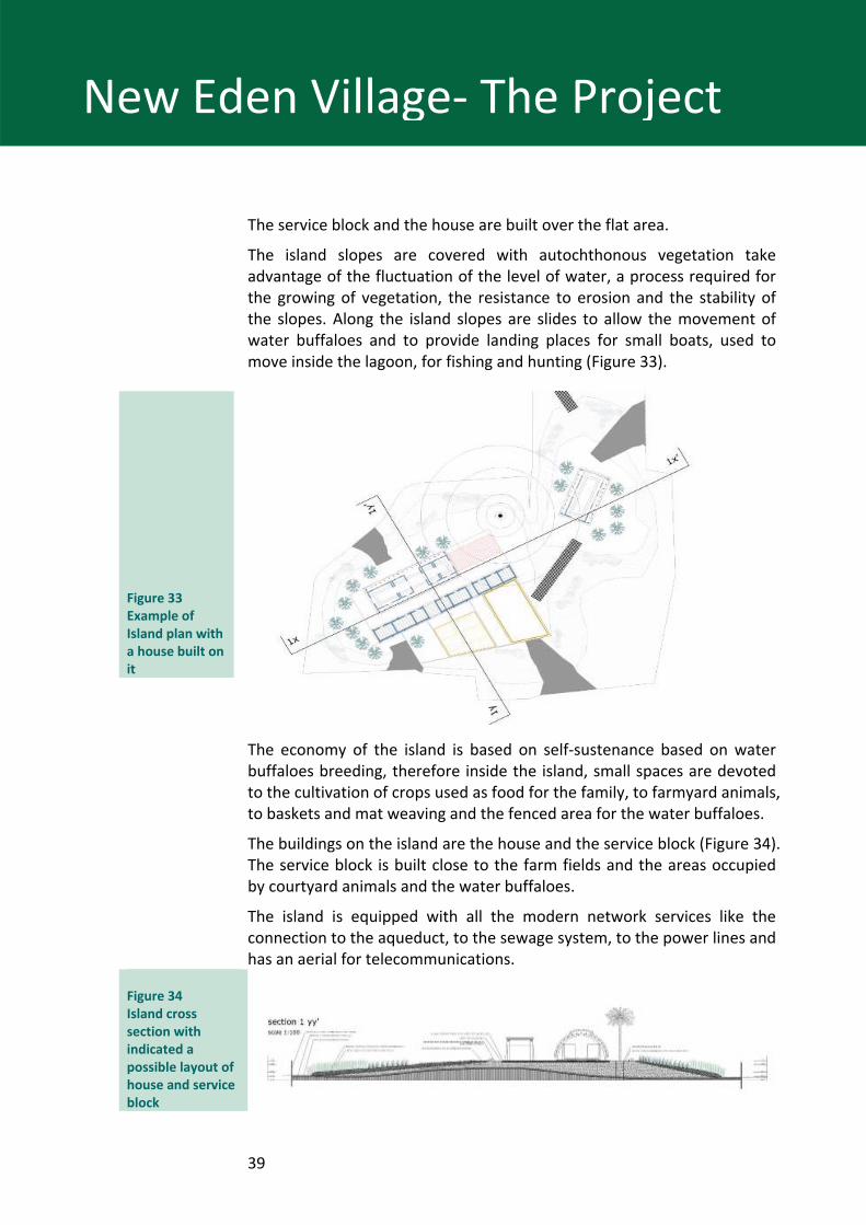
The service block and the house are built over the flat area.
The island slopes are covered with autochthonous vegetation take advantage of the fluctuation of the level of water, a process required for the growing of vegetation, the resistance to erosion and the stability of the slopes. Along the island slopes are slides to allow the movement of water buffaloes and to provide landing places for small boats, used to move inside the lagoon, for fishing and hunting (Figure 33).
Figure 33 Example of Island plan with a house built on it
The economy of the island is based on self‐sustenance based on water buffaloes breeding, therefore inside the island, small spaces are devoted to the cultivation of crops used as food for the family, to farmyard animals, to baskets and mat weaving and the fenced area for the water buffaloes.
The buildings on the island are the house and the service block (Figure 34). The service block is built close to the farm fields and the areas occupied by courtyard animals and the water buffaloes.
The island is equipped with all the modern network services like the connection to the aqueduct, to the sewage system, to the power lines and has an aerial for telecommunications.
Figure 34 Island cross section with indicated a possible layout of house and service block
40
New Eden Village‐ The Project
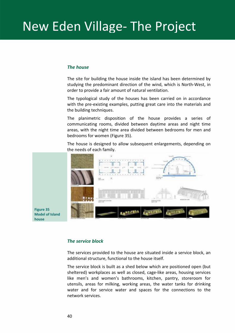
The house
The site for building the house inside the island has been determined by studying the predominant direction of the wind, which is North‐West, in order to provide a fair amount of natural ventilation.
The typological study of the houses has been carried on in accordance with the pre‐existing examples, putting great care into the materials and the building techniques.
The planimetric disposition of the house provides a series of communicating rooms, divided between daytime areas and night time areas, with the night time area divided between bedrooms for men and bedrooms for women (Figure 35).
The house is designed to allow subsequent enlargements, depending on the needs of each family.
Figure 35 Model of Island house
The service block
The services provided to the house are situated inside a service block, an additional structure, functional to the house itself.
The service block is built as a shed below which are positioned open (but sheltered) workplaces as well as closed, cage‐like areas, housing services like men’s and women’s bathrooms, kitchen, pantry, storeroom for utensils, areas for milking, working areas, the water tanks for drinking water and for service water and spaces for the connections to the network services.
41
New Eden Village‐ The Project
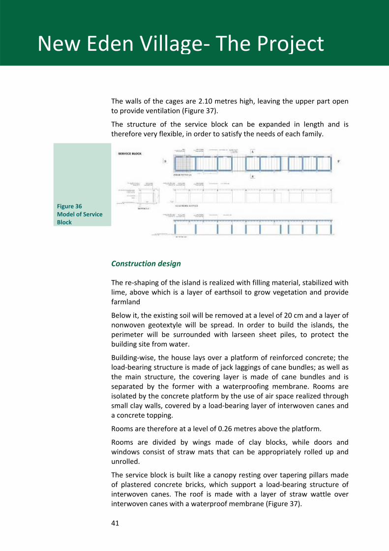
The walls of the cages are 2.10 metres high, leaving the upper part open to provide ventilation (Figure 37).
The structure of the service block can be expanded in length and is therefore very flexible, in order to satisfy the needs of each family.
Figure 36 Model of Service Block
Construction design
The re‐shaping of the island is realized with filling material, stabilized with lime, above which is a layer of earthsoil to grow vegetation and provide farmland
Below it, the existing soil will be removed at a level of 20 cm and a layer of nonwoven geotextyle will be spread. In order to build the islands, the perimeter will be surrounded with larseen sheet piles, to protect the building site from water.
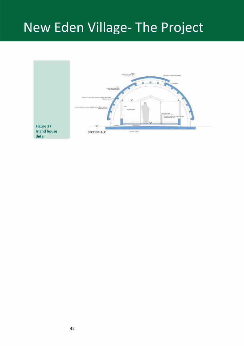
Building‐wise, the house lays over a platform of reinforced concrete; the load‐bearing structure is made of jack laggings of cane bundles; as well as the main structure, the covering layer is made of cane bundles and is separated by the former with a waterproofing membrane. Rooms are isolated by the concrete platform by the use of air space realized through small clay walls, covered by a load‐bearing layer of interwoven canes and a concrete topping.
Rooms are therefore at a level of 0.26 metres above the platform.
Rooms are divided by wings made of clay blocks, while doors and windows consist of straw mats that can be appropriately rolled up and unrolled.
The service block is built like a canopy resting over tapering pillars made of plastered concrete bricks, which support a load‐bearing structure of interwoven canes. The roof is made with a layer of straw wattle over interwoven canes with a waterproof membrane (Figure 37).
42
New Eden Village‐ The Project
Figure 37 Island house detail
43
New Eden Village‐ The Project
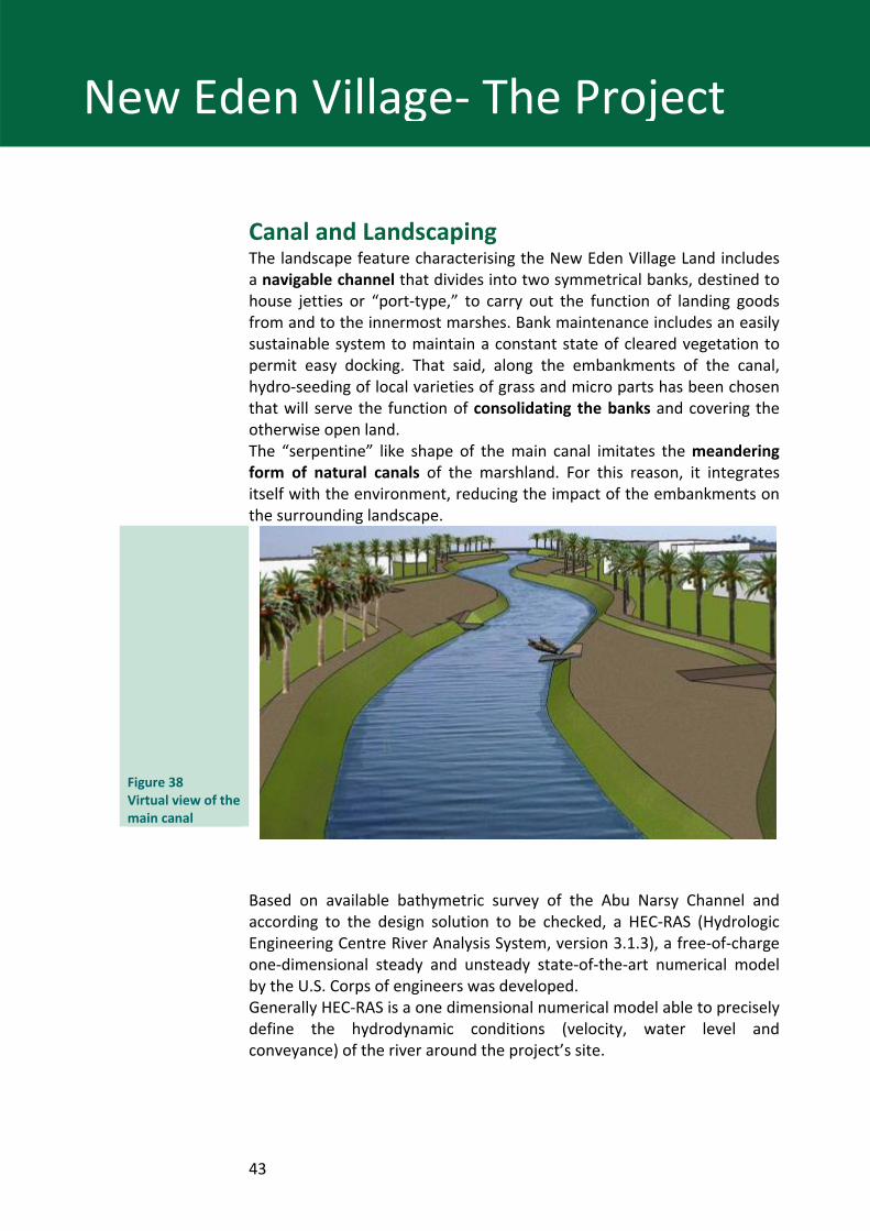
Canal and Landscaping The landscape feature characterising the New Eden Village Land includes a navigable channel that divides into two symmetrical banks, destined to house jetties or “port‐type,” to carry out the function of landing goods from and to the innermost marshes. Bank maintenance includes an easily sustainable system to maintain a constant state of cleared vegetation to permit easy docking. That said, along the embankments of the canal, hydro‐seeding of local varieties of grass and micro parts has been chosen that will serve the function of consolidating the banks and covering the otherwise open land. The “serpentine” like shape of the main canal imitates the meandering form of natural canals of the marshland. For this reason, it integrates itself with the environment, reducing the impact of the embankments on the surrounding landscape.
Figure 38 Virtual view of the main canal
Based on available bathymetric survey of the Abu Narsy Channel and according to the design solution to be checked, a HEC‐RAS (Hydrologic Engineering Centre River Analysis System, version 3.1.3), a free‐of‐charge one‐dimensional steady and unsteady state‐of‐the‐art numerical model by the U.S. Corps of engineers was developed. Generally HEC‐RAS is a one dimensional numerical model able to precisely define the hydrodynamic conditions (velocity, water level and conveyance) of the river around the project’s site.
44
New Eden Village‐ The Project
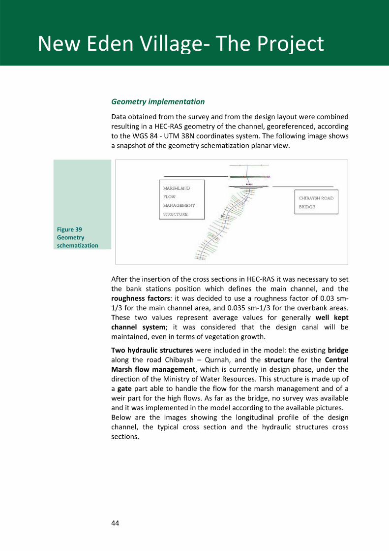
Geometry implementation
Data obtained from the survey and from the design layout were combined resulting in a HEC‐RAS geometry of the channel, georeferenced, according to the WGS 84 ‐ UTM 38N coordinates system. The following image shows a snapshot of the geometry schematization planar view.
Figure 39 Geometry schematization
After the insertion of the cross sections in HEC‐RAS it was necessary to set the bank stations position which defines the main channel, and the roughness factors: it was decided to use a roughness factor of 0.03 sm‐1/3 for the main channel area, and 0.035 sm‐1/3 for the overbank areas. These two values represent average values for generally well kept channel system; it was considered that the design canal will be maintained, even in terms of vegetation growth.
Two hydraulic structures were included in the model: the existing bridge along the road Chibaysh – Qurnah, and the structure for the Central Marsh flow management, which is currently in design phase, under the direction of the Ministry of Water Resources. This structure is made up of a gate part able to handle the flow for the marsh management and of a weir part for the high flows. As far as the bridge, no survey was available and it was implemented in the model according to the available pictures. Below are the images showing the longitudinal profile of the design channel, the typical cross section and the hydraulic structures cross sections.
45
New Eden Village‐ The Project
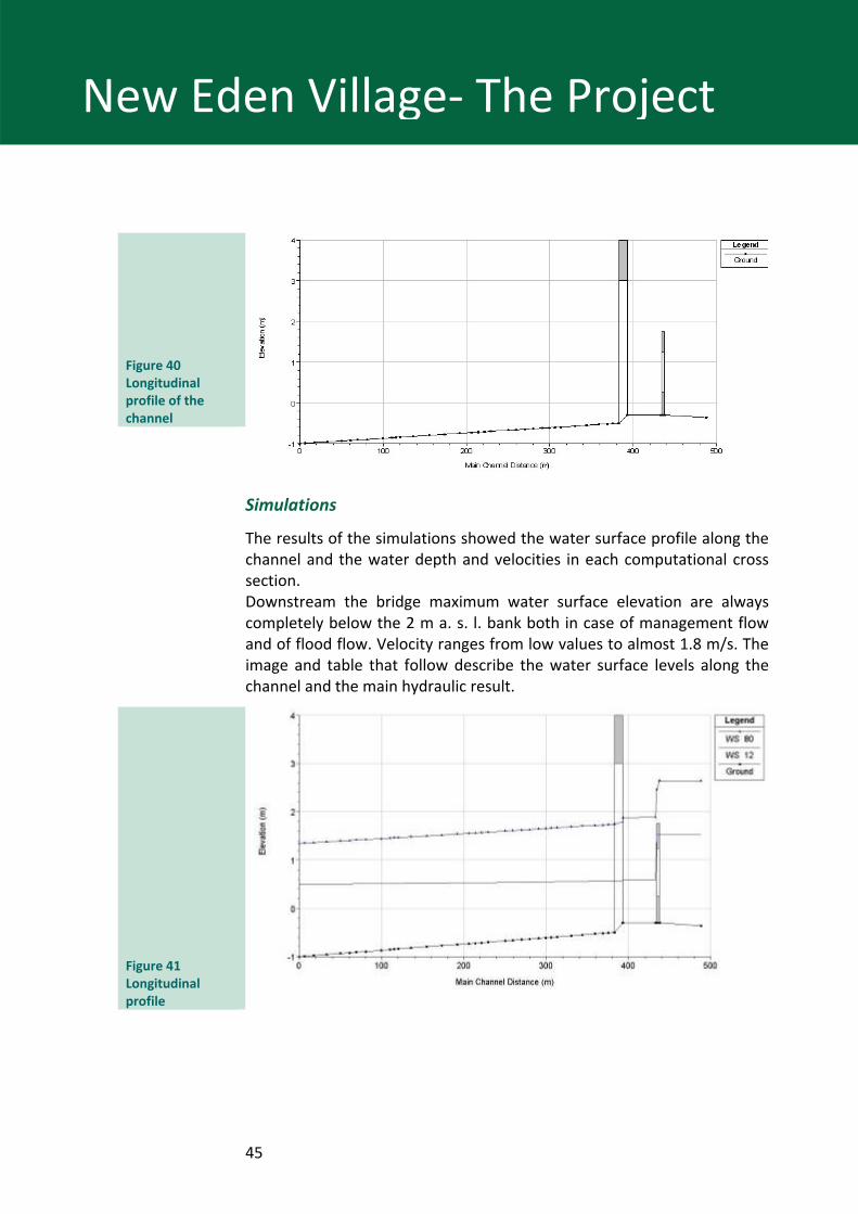
Figure 40 Longitudinal profile of the channel
Simulations
The results of the simulations showed the water surface profile along the channel and the water depth and velocities in each computational cross section. Downstream the bridge maximum water surface elevation are always completely below the 2 m a. s. l. bank both in case of management flow and of flood flow. Velocity ranges from low values to almost 1.8 m/s. The image and table that follow describe the water surface levels along the channel and the main hydraulic result.
Figure 41 Longitudinal profile
46
New Eden Village‐ The Project
Flood due to Euphrates
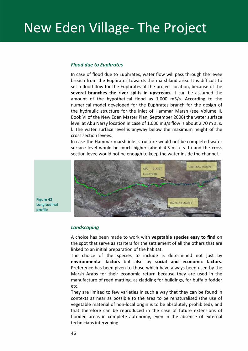
In case of flood due to Euphrates, water flow will pass through the levee breach from the Euphrates towards the marshland area. It is difficult to set a flood flow for the Euphrates at the project location, because of the several branches the river splits in upstream. It can be assumed the amount of the hypothetical flood as 1,000 m3/s. According to the numerical model developed for the Euphrates branch for the design of the hydraulic structure for the inlet of Hammar Marsh (see Volume II, Book VI of the New Eden Master Plan, September 2006) the water surface level at Abu Narsy location in case of 1,000 m3/s flow is about 2.70 m a. s. l. The water surface level is anyway below the maximum height of the cross section levees. In case the Hammar marsh inlet structure would not be completed water surface level would be much higher (about 4.3 m a. s. l.) and the cross section levee would not be enough to keep the water inside the channel.
Figure 42 Longitudinal profile
Landscaping
A choice has been made to work with vegetable species easy to find on the spot that serve as starters for the settlement of all the others that are linked to an initial preparation of the habitat. The choice of the species to include is determined not just by environmental factors but also by social and economic factors. Preference has been given to those which have always been used by the Marsh Arabs for their economic return because they are used in the manufacture of reed matting, as cladding for buildings, for buffalo fodder etc. They are limited to few varieties in such a way that they can be found in contexts as near as possible to the area to be renaturalised (the use of vegetable material of non‐local origin is to be absolutely prohibited), and that therefore can be reproduced in the case of future extensions of flooded areas in complete autonomy, even in the absence of external technicians intervening.
47
Prototype house
New Eden House pilot project
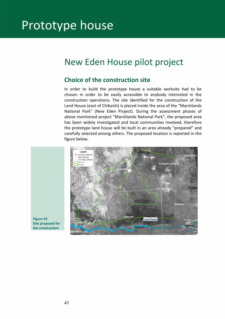
Choice of the construction site In order to build the prototype house a suitable worksite had to be chosen in order to be easily accessible to anybody interested in the construction operations. The site identified for the construction of the Land House (east of Chibaish) is placed inside the area of the “Marshlands National Park” (New Eden Project). During the assessment phases of above mentioned project “Marshlands National Park”, the proposed area has been widely investigated and local communities involved, therefore the prototype land house will be built in an area already “prepared” and carefully selected among others. The proposed location is reported in the figure below.
Figure 43 Site proposed for the construction
48
Prototype house
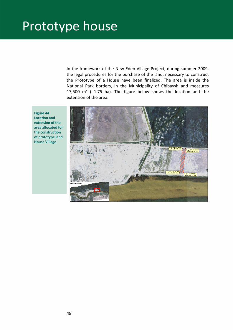
In the framework of the New Eden Village Project, during summer 2009, the legal procedures for the purchase of the land, necessary to construct the Prototype of a House have been finalized. The area is inside the National Park borders, in the Municipality of Chibaysh and measures 17,500 m2 ( 1.75 ha). The figure below shows the location and the extension of the area.
Figure 44 Location and extension of the area allocated for the construction of prototype land House Village
49
Prototype house
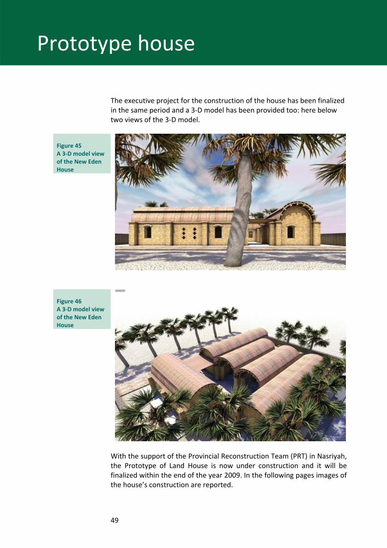
The executive project for the construction of the house has been finalized in the same period and a 3‐D model has been provided too: here below two views of the 3‐D model.
Figure 45 A 3‐D model view of the New Eden House
Figure 46 A 3‐D model view of the New Eden House
With the support of the Provincial Reconstruction Team (PRT) in Nasriyah, the Prototype of Land House is now under construction and it will be finalized within the end of the year 2009. In the following pages images of the house’s construction are reported.
50
Prototype house
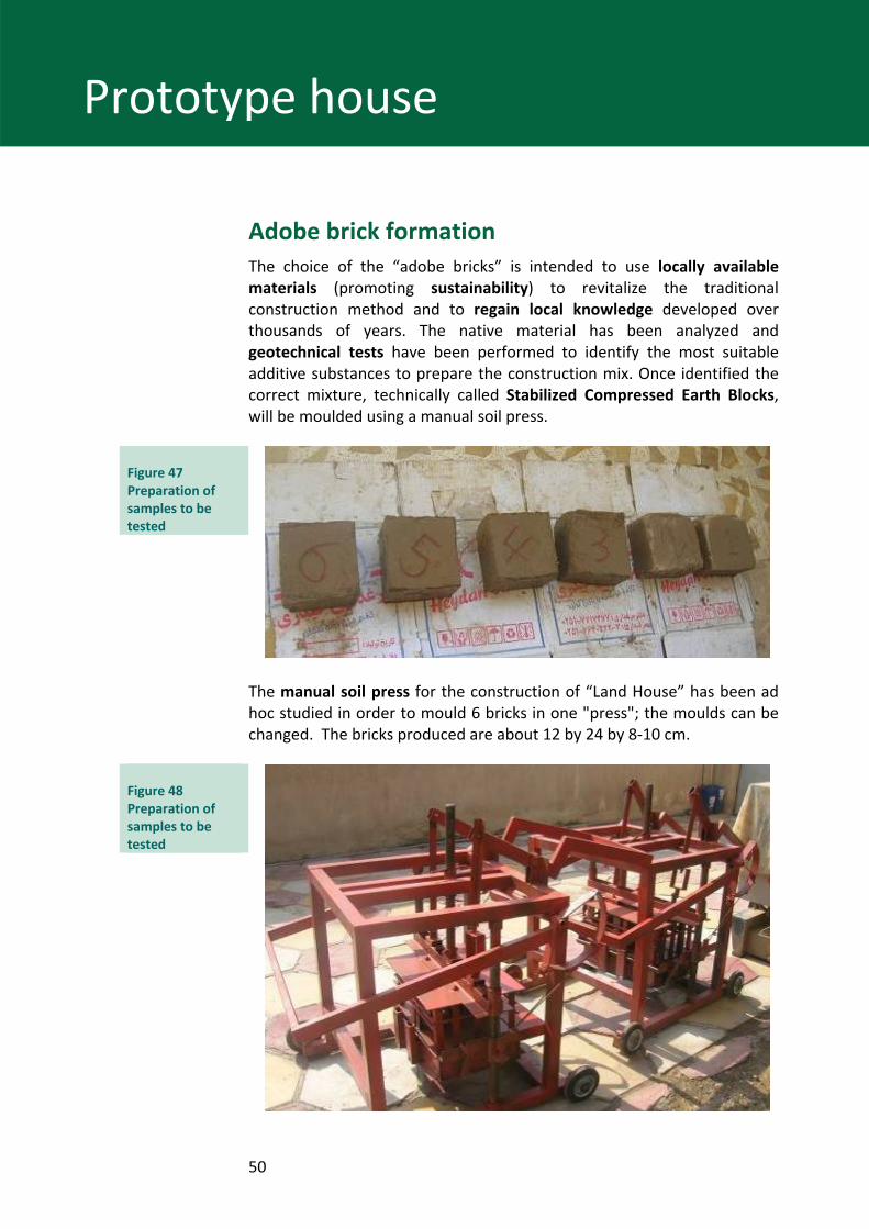
Adobe brick formation The choice of the “adobe bricks” is intended to use locally available materials (promoting sustainability) to revitalize the traditional construction method and to regain local knowledge developed over thousands of years. The native material has been analyzed and geotechnical tests have been performed to identify the most suitable additive substances to prepare the construction mix. Once identified the correct mixture, technically called Stabilized Compressed Earth Blocks, will be moulded using a manual soil press.
Figure 47 Preparation of samples to be tested
The manual soil press for the construction of “Land House” has been ad hoc studied in order to mould 6 bricks in one "press"; the moulds can be changed. The bricks produced are about 12 by 24 by 8‐10 cm.
Figure 48 Preparation of samples to be tested
51
Prototype house
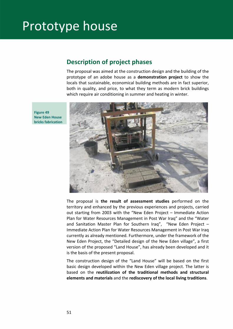
Description of project phases The proposal was aimed at the construction design and the building of the prototype of an adobe house as a demonstration project to show the locals that sustainable, economical building methods are in fact superior, both in quality, and price, to what they term as modern brick buildings which require air conditioning in summer and heating in winter.
Figure 49 New Eden House bricks fabrication
The proposal is the result of assessment studies performed on the territory and enhanced by the previous experiences and projects, carried out starting from 2003 with the “New Eden Project – Immediate Action Plan for Water Resources Management in Post War Iraq” and the “Water and Sanitation Master Plan for Southern Iraq”, “New Eden Project – Immediate Action Plan for Water Resources Management in Post War Iraq currently as already mentioned. Furthermore, under the framework of the New Eden Project, the “Detailed design of the New Eden village”, a first version of the proposed “Land House”, has already been developed and it is the basis of the present proposal.
The construction design of the “Land House” will be based on the first basic design developed within the New Eden village project. The latter is based on the reutilization of the traditional methods and structural elements and materials and the rediscovery of the local living traditions.
52
Prototype house
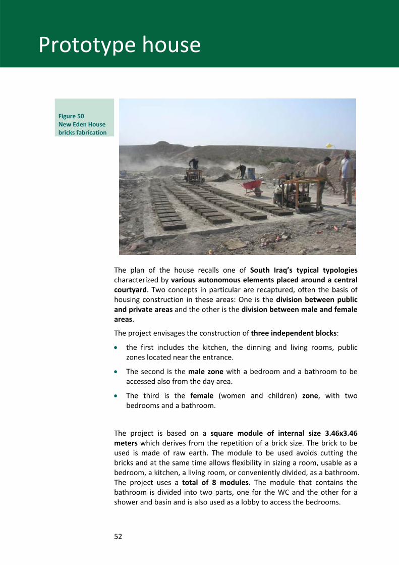
Figure 50 New Eden House bricks fabrication
The plan of the house recalls one of South Iraq’s typical typologies characterized by various autonomous elements placed around a central courtyard. Two concepts in particular are recaptured, often the basis of housing construction in these areas: One is the division between public and private areas and the other is the division between male and female areas.
The project envisages the construction of three independent blocks:
• the first includes the kitchen, the dinning and living rooms, public zones located near the entrance.
• The second is the male zone with a bedroom and a bathroom to be accessed also from the day area.
• The third is the female (women and children) zone, with two bedrooms and a bathroom.
The project is based on a square module of internal size 3.46x3.46 meters which derives from the repetition of a brick size. The brick to be used is made of raw earth. The module to be used avoids cutting the bricks and at the same time allows flexibility in sizing a room, usable as a bedroom, a kitchen, a living room, or conveniently divided, as a bathroom. The project uses a total of 8 modules. The module that contains the bathroom is divided into two parts, one for the WC and the other for a shower and basin and is also used as a lobby to access the bedrooms.
53
Prototype house
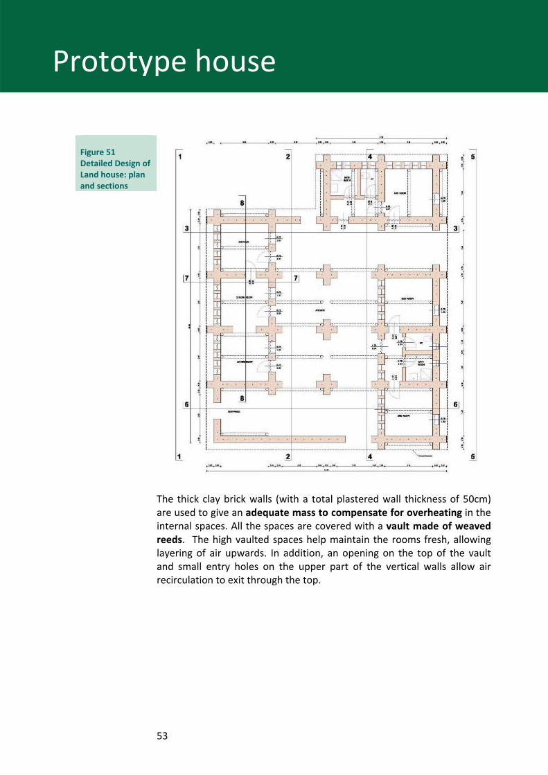
Figure 51 Detailed Design of Land house: plan and sections
The thick clay brick walls (with a total plastered wall thickness of 50cm) are used to give an adequate mass to compensate for overheating in the internal spaces. All the spaces are covered with a vault made of weaved reeds. The high vaulted spaces help maintain the rooms fresh, allowing layering of air upwards. In addition, an opening on the top of the vault and small entry holes on the upper part of the vertical walls allow air recirculation to exit through the top.
54
Prototype house
Figure 52 Iron bars arrangement
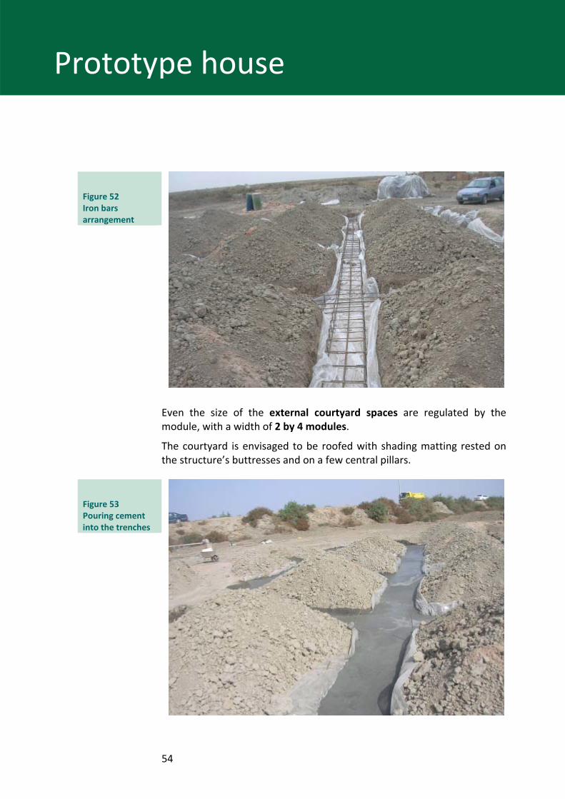
Even the size of the external courtyard spaces are regulated by the module, with a width of 2 by 4 modules.
The courtyard is envisaged to be roofed with shading matting rested on the structure’s buttresses and on a few central pillars.
Figure 53 Pouring cement into the trenches
55
Prototype house
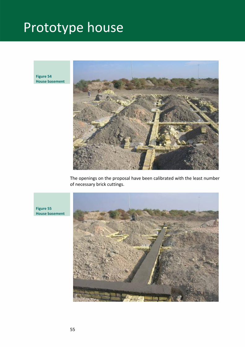
Figure 54 House basement
The openings on the proposal have been calibrated with the least number of necessary brick cuttings.
Figure 55 House basement
56
Prototype house
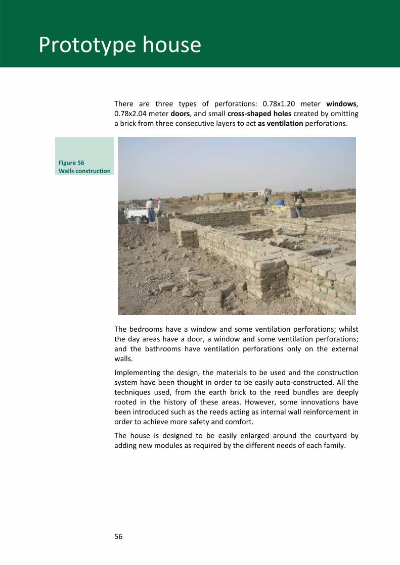
There are three types of perforations: 0.78x1.20 meter windows, 0.78x2.04 meter doors, and small cross‐shaped holes created by omitting a brick from three consecutive layers to act as ventilation perforations.
Figure 56 Walls construction
The bedrooms have a window and some ventilation perforations; whilst the day areas have a door, a window and some ventilation perforations; and the bathrooms have ventilation perforations only on the external walls.
Implementing the design, the materials to be used and the construction system have been thought in order to be easily auto‐constructed. All the techniques used, from the earth brick to the reed bundles are deeply rooted in the history of these areas. However, some innovations have been introduced such as the reeds acting as internal wall reinforcement in order to achieve more safety and comfort.
The house is designed to be easily enlarged around the courtyard by adding new modules as required by the different needs of each family.
57
Prototype house
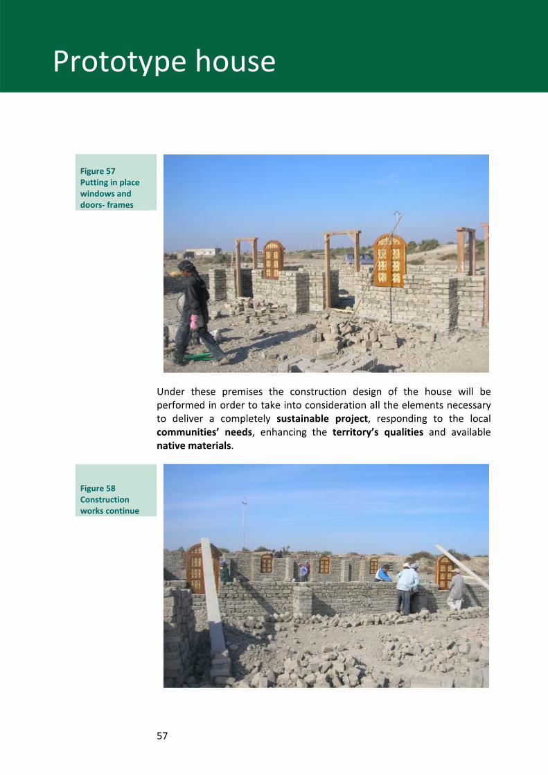
Figure 57 Putting in place windows and doors‐ frames
Under these premises the construction design of the house will be performed in order to take into consideration all the elements necessary to deliver a completely sustainable project, responding to the local communities’ needs, enhancing the territory’s qualities and available native materials.
Figure 58 Construction works continue
58
Prototype house
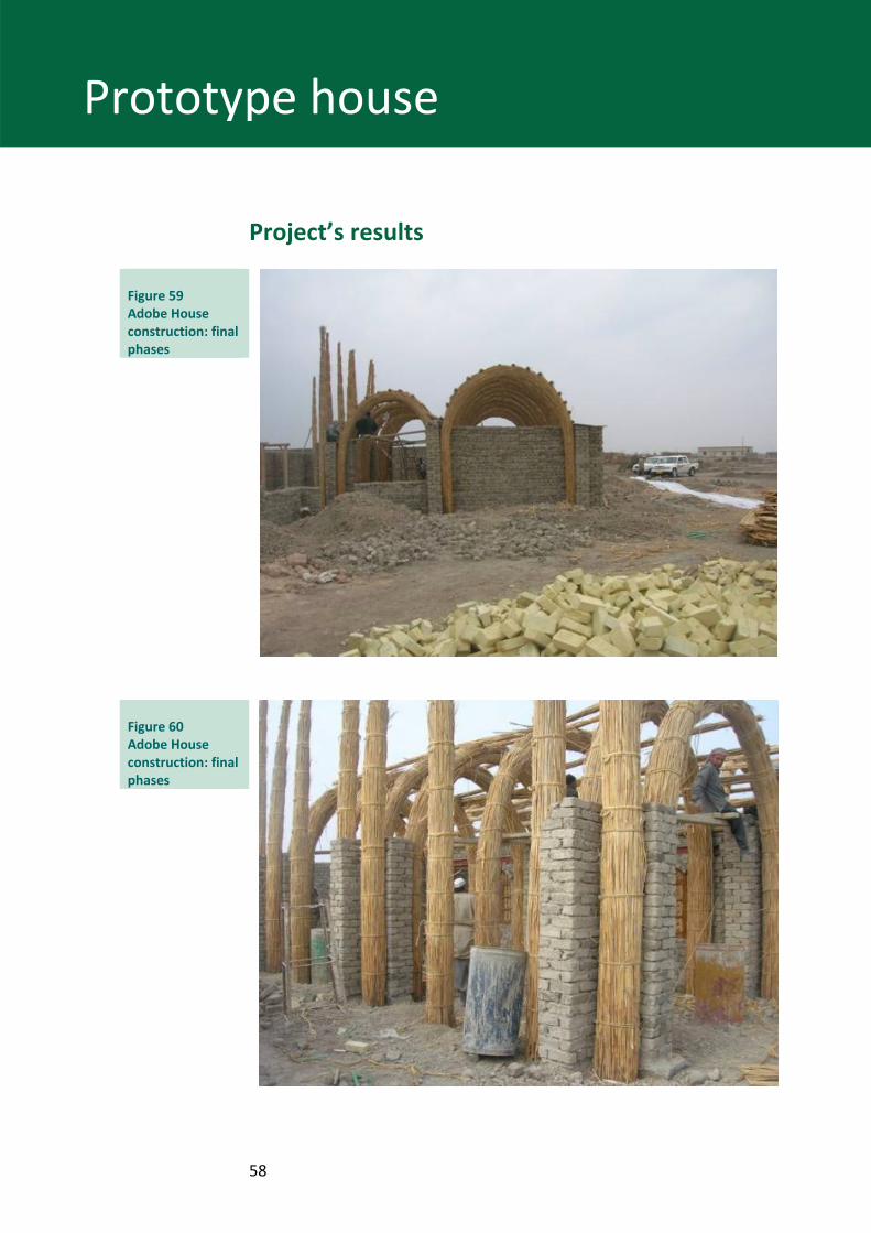
Project’s results
Figure 59 Adobe House construction: final phases
Figure 60 Adobe House construction: final phases
59
Prototype house
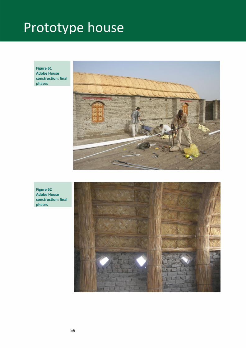
Figure 61 Adobe House construction: final phases
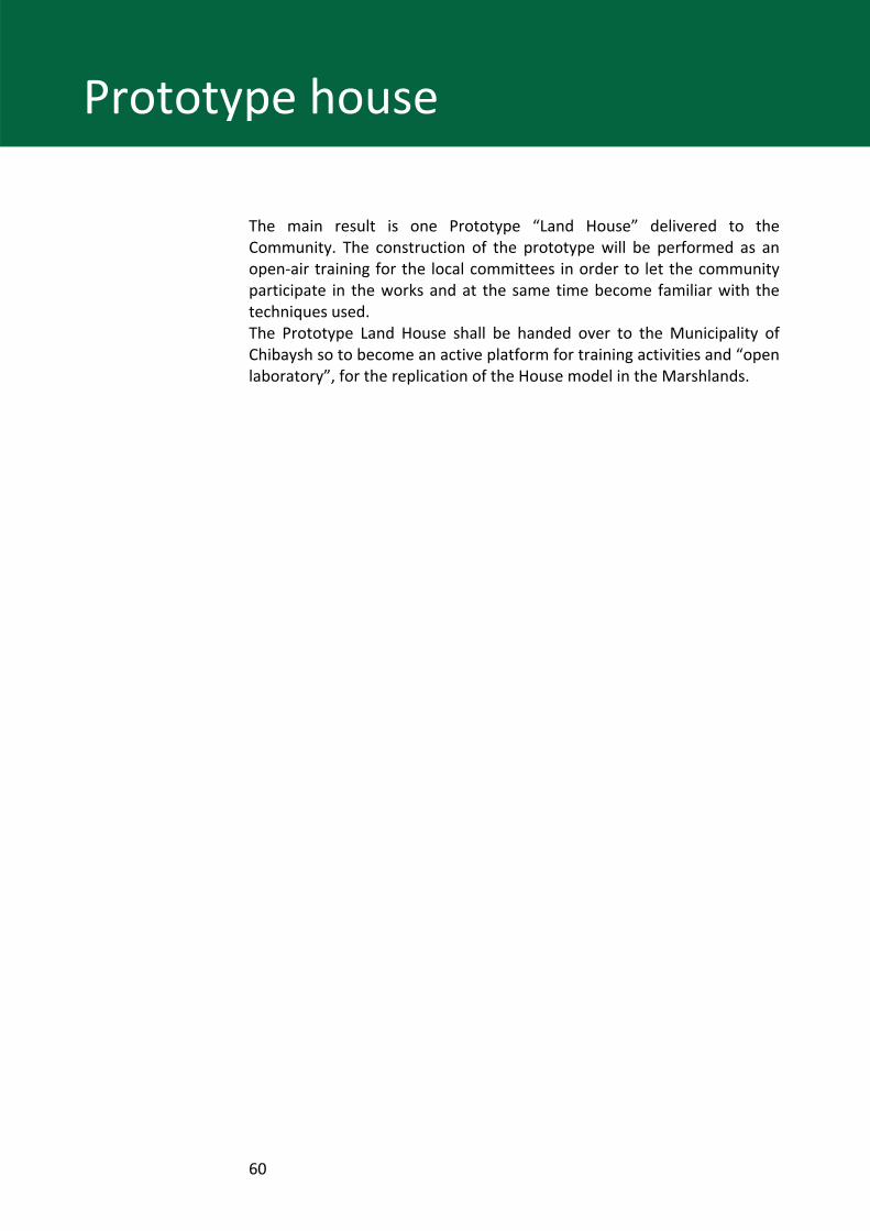
Figure 62 Adobe House construction: final phases
60
Prototype house
The main result is one Prototype “Land House” delivered to the Community. The construction of the prototype will be performed as an open‐air training for the local committees in order to let the community participate in the works and at the same time become familiar with the techniques used. The Prototype Land House shall be handed over to the Municipality of Chibaysh so to become an active platform for training activities and “open laboratory”, for the replication of the House model in the Marshlands.
61
References References
Study,” eds. Peter Clark and Sean Magee Alexander Tkachenko, “The Iraqi Marshlands: A Human and Environmental, the AMAR International Charitable Foundation, 2001
Italian Ministry for the Environment and Territory, Free Iraq Foundation/Nature Iraq, New Eden Master Plan for Integrated Water Resources Management in the Marshlands Area, 15 September 2006, Italy.
IRAQI MINISTRIES of Water Resources, Municipalities and Public Works (in cooperation with The Italian Ministry for the Environment Land and Sea and Free Iraq Foundation): Detailed design of New Eden Village URBAN LAYOUT, ITALY ‐ IRAQ April 2008.
IRAQI MINISTRIES of Water Resources, Municipalities and Public Works (in cooperation with The Italian Ministry for the Environment Land and Sea and Free Iraq Foundation): Detailed design of New Eden Village The layout of the canal and landscaping, Italy ‐ Iraq April 2008.
Washington Post, Iraq’s Marsh Arabs. http://www.washingtonpost.com/wp‐dyn/content/gallery/2009/07/23/GA2009072303612.html