Embed Size (px)
Citation preview
Newborough Forest
Management Plan
2010-15

Newborough Forest Management Plan – FINAL v1.0
- 2 -
This page has been left intentionally blank

Newborough Forest Management Plan – FINAL v1.0
- 3 -
TABLE OF CONTENTS
Page
SECTION 1: Background ……………………..…..…………………………………………. 4
1.1 Ownership ………………………………………………………………………………………………………….. 41.2 Context of this Plan ………………………………………………………………………………………….. 41.3 Legal and Other Issues …………………………………………………………………………………….. 5
SECTION 2: Management Plan Features ……………………………………………….. 10
2.1 List of Features ………………..……….………………………………………………………………………. 102.2 Rationale for Choosing Each Feature ……………………………………………………………. 112.3 Description of Each Feature …………………………………………………………………………….. 12
SECTION 3: Vision for Newborough Forest and Coast……………………………… 18
3.1 Long-term vision for how the forest and coast should be in
20 to 50 years’ time …………………………………………………………………………………………. 18
SECTION 4: Desired Characteristics of Each Feature .………….…………………. 19
4.1 Desired Characteristics of the Forest Feature ……………………………………………. 194.2 Desired Characteristics of the Sand Dunes Feature ………………………………….. 204.3 Desired Characteristics of the Shore Dock Feature …………………………………… 214.4 Desired Characteristics of the Recreation Feature ……………………………………. 224.5 Desired Characteristics of the Community Involvement Feature ………….. 244.6 Desired Characteristics of the Geology & Geomorphology Feature ……….. 25
SECTION 5: General Approach to Managing Each Feature ………………..……. 26
5.1 General Approach to Managing the Forest Feature ………………………………….. 265.2 General Approach to Managing the Sand Dunes Feature ………………………… 305.3 General Approach to Managing the Shore Dock Feature …………………………. 325.4 General Approach to Managing the Recreation Feature ………………………….. 335.5 General Approach to Managing the Community Involvement Feature …. 345.6 General Approach to Managing the Geology & Geomorphology Feature . 36
SECTION 6: Operational Priorities for Managing Each Feature ………………… 37
6.1 Proposed Actions for the Forest Feature ……………………………………………………… 376.2 Proposed Actions for the Sand Dunes Feature ……………………………………………. 466.3 Proposed Actions for the Shore Dock Feature …………………………………………….. 486.4 Proposed Actions for the Recreation Feature ………………………………………………. 506.5 Proposed Actions for the Community Involvement Feature …………………….. 546.6 Proposed Actions for the Geology & Geomorphology Feature …………………..55
SECTION 7: APPENDICES …………………………………………………………………… 56
APPENDIX 1: Newborough Forest Statistics …………………………………………. 56
APPENDIX 2: Special Areas of Conservation (SACs) ………………………………. 58
APPENDIX 2A: Abermenai to Aberffraw Dunes SAC ……………………… 58
APPENDIX 2B: Anglesey Coast Saltmarsh SAC …………………………….. 59
APPENDIX 2C: Glan-traeth SAC …………………………………………………. 60
APPENDIX 2D: HRA Screening for Newborough Forest …………………. 61
APPENDIX 3: Isle of Anglesey LBAP ……………………………………………………. 64
APPENDIX 4: Trees Potentially Suitable for Planting at Newborough ………. 65
APPENDIX 5: List of Abbreviations ………………………………………………………. 70
APPENDIX 6: Map of Newborough Forest ……………………………………………… 72

Newborough Forest Management Plan – FINAL v1.0
- 4 -
SECTION 1: BACKGROUND
1.1 Ownership
1.1.1 Name of the forest: Newborough Forest1.1.2 Name of owner / occupier: National Assembly for Wales
(transferred from the Secretary of State for Wales –deeds LR378 & LR395 – and Ministry of AgricultureFood & Fisheries – deeds LR35, LR36, LR50 & LR74)
1.1.3 Basic details of the forest See Appendix 11.1.4 Map of the forest See Appendix 61.1.5 Management of the forest Managed on behalf of the Welsh Assembly
Government by Forestry Commission Wales1.1.6 Address (of local office): Forestry Commission Wales,
Coed y Mynydd Forest District,Government Buildings, Arran Road, Dolgellau,Gwynedd, LL40 1LW
The freehold of Newborough Forest rests with the National Assembly for Wales (NAW)and is managed on behalf of the Welsh Assembly Government (WAG) by ForestryCommission Wales (FCW). The people of Wales, the local communities around thevillage of Newborough and visitors to the forest are therefore important stakeholders inthe management of Newborough Forest.
The Countryside Council for Wales (CCW) leases the area of the shoreline between themean high water mark and the base of the dunes, also a large area of saltmarsh to thenorth-west of the forest, both areas being managed as part of the National NatureReserve (NNR). CCW also has an access lease for nature conservation purposes over therest of Newborough Forest and leases Ynys Llanddwyn (Llanddwyn Island) from Isle ofAnglesey County Council (IoACC). IoACC leases Newborough Beach (between the meanhigh water mark and mean low water mark) from Crown Estates.
1.2 Context of this Plan
1.2.1 Preparation of this draft of the Management Plan:
Name:
Position:
Address:
Phone Number:
Email:
John BrowneDistrict Forester PlanningAs above0300 068 [email protected]
Point of contact for this plan: District Forester Planning, details as above
1.2.2 About the forest:
Location: Newborough, Isle of AngleseyTotal area of plan / of forest: 951 hectares / 689 hectaresSite designations: SSSI, SAC, AONB
• SAC documentation in Appendix 2• LBAP in Appendix 3Note that the small section of forest north east of theA4080 is outwith the SSSI, SAC and AONB (see Map1.1 below)
Grid reference: SH 414649 (Main entrance to the forest)
Newborough Forest Management Plan – FINAL v1.0
- 5 -
This management plan is required because Newborough Forest lies within a Special Areaof Conservation (SAC) and is adjacent to two further SACs. The importance of this isexplained further in Section 1.3 below, and more detailed information about the SACscan be found in Appendix 2. This coverage by SACs means that the forest is part of thewider Natura 2000 Network, a European designation aimed at conserving globalbiodiversity in line with international obligations. The objective of SACs is to enablevulnerable habitats and species – of which there are some 230 threatened habitat typesand 1,000 listed species within Europe – to be maintained, or where necessary, restoredto favourable conservation status. The Natura 2000 Network presently contains around25,000 sites, or almost a fifth of the European territory. In Wales there are 90 sitesincluding marine SACs but covering a total land area of some 187,614 hectares, oraround 9% of the land area of Wales.
This management plan fulfils the function of a formal Forest Design Plan (FDP), arequirement for the management of all woodlands within the Assembly Woodland Estate(AWE). An FDP is also required for compliance with the UK Woodland CertificationScheme (UKWAS), a standard that enables FCW to market its range of products ascertified under its two certification schemes: The Forestry Stewardship Council Scheme(FSC) and the Programme for the Endorsement of Forest Certification Schemes (PEFC).
The EU Habitats Directive guidance recommends using management plans to helpestablish dialogue between all interested parties and to communicate practicalmanagement solutions. This plan will be used to keep the Newborough LiaisonPartnership (NLP) – and in due course its successor group – informed of developmentsand to seek the group’s comments and guidance. The NLP was established in 2005 andinitially met with a facilitator to debate the community aspirations from NewboroughForest, producing its recommendations in December 2006. These recommendationsinform this management plan and where possible are incorporated within it. It isexpected that the NLP will reform itself into a further liaison group to assist themanagement of the forest and dunes once this management plan is approved. Thispoint will be explored further by the NLP in due course.
This plan acknowledges the work carried out by the Newborough Forest Science Reviewover the period 2009-10, which has involved scientists from the Newborough ForestPartnership (NFP) and is chaired by CCW. At the time of writing the science review is inarbitration, but when this process has concluded and is signed off by the WelshAssembly Government (WAG) then this plan will be updated to incorporate WAGdecisions on the forest. The science review is covered further in Section 1.3.1 below.
1.3 Legal and Other Issues
The main legislation applying to the forest is:
• The Habitats Regulations (Conservation (Natural Habitats &c.) Regulations, 1994),which transpose the EU Habitats Directive 1992 (Council Directive 92/43/EEC) intoUK law and establish protective regimes both for European sites and Europeanprotected species (EPS). The Regulations were further amended in 2007 and 2010(The Conservation of Habitats and Species Regulations 2010). The main Special Areaof Conservation (SAC) covering Newborough Forest – the Abermenai to AberffrawDunes Special Area of Conservation (SAC Reference UK0020021) – was designatedunder EC Habitats Directive 1992 in 2004.
• The Natural Environment & Rural Communities Act 2006 (Sections 40 & 42 regardingbiodiversity duties).
• The Countryside & Rights of Way Act 2000 (regarding open access, also Schedule 85regarding the AONB).
• The Environmental Impact Assessment (Forestry) (England and Wales) Regulations
1999 [SI 1999/2228], updated 2006.

Newborough Forest Management Plan – FINAL v1.0
- 6 -
• The Wildlife & Countryside Act 1981 (as amended by Schedule 9 of the Countryside &Rights of Way Act 2000).
• The Forestry Act 1967 as amended.
Newborough Forest lies almost completely within one Special Area of Conservation(Abermenai to Aberffraw Dunes SAC); has a slither within a second SAC (Anglesey CoastSaltmarsh SAC); and is adjacent to a third SAC (Glan-traeth SAC). Maps of these SACsare shown in Figure 1.1 below. The entire forest south of the A4080 is within the YnysLlanddwyn-Newborough Warren Site of Special Scientific Interest (SSSI), and there areother SSSIs nearby (see Figure 1.2). The proximity of SACs is a further importantconsideration in carrying out the Habitats Regulations Assessment (HRA) on theoperations proposed within this management plan.
Figure 1.1: Boundary maps of SACs covering & adjacent to Newborough Forest
Map 1.1a: Abermenai to Aberffraw Dunes SAC
Figure 1.2: Areas of SSSIs around Newborough Forest
Maps copyright Ordnance Survey; produced with permission from CCW
SAC designation requires European member states to establish conservation measurescorresponding to the ecological requirements of the Annex I habitats and Annex IIspecies present on the site (Article 6.1), and to take appropriate steps to avoiddeterioration of the natural habitats and habitats of species as well as significantdisturbance of the species for which the site is designated (Article 6.2). This includes theHRA of the implications of any plans or projects that, alone or in combination, are likelyto have a significant effect on the site in view of the site’s conservation objectives(Article 6.3). Details of the 3 SACs illustrated in Figure 1.1 can be found in Appendix 2.
1.3.1 Abermenai to Aberffraw Dunes SAC
The Abermenai to Aberffraw Dunes SAC was designated in 2004 for the following habitattypes and species listed in Annexes I & II of the 1992 EC Habitats Directive:
• Embryonic shifting dunes
Key: Notified Site of Special Scientific Interest (SSSI)
Map1.1b: Anglesey Coast Saltmarsh SAC
Map1.1c: Glan-traeth SAC

Newborough Forest Management Plan – FINAL v1.0
- 7 -
• Shifting dunes along the shoreline with Ammophila arenaria (‘white dunes’)• Fixed dunes with herbaceous vegetation (‘grey dunes’)• Dunes with Salix repens spp. argentea (Salicion arenariae)• Humid dune slacks• Petalwort (Petalophyllum ralfsii)• Shore dock (Rumex rupestris)
CCW has advised FCW that to comply with Article 6.1 of the Directive and to move thefive sand dune habitats and two species listed above towards favourable conservationstatus the trees in a limited area of Newborough forest need to be removed. CCW saythat this is to allow the restoration of a natural dune zonation behind the shoreline andto address the perceived impacts of the forest on the hydrology of the designatedhabitats. The definition of favourable conservation status is given in Table 1.1 below:
Table 1.1: Definition of favourable conservation status (Article 1)
Figure 1.3 below shows how Newborough Forest fits within the wider area of SACs(Abermenai to Aberffraw Dunes SAC, Anglesey Coast Saltmarsh SAC and Glan-traethSAC). The 728 hectares of Newborough Forest within SAC represents 39% of the area
of the Abermenai to Aberffraw Dunes SAC. The forest is therefore a significantfeature within this SAC.
Figure 1.3 also shows the proportion of the SAC dune foreshore that is occupied by theforest, the forested foreshore being 30% of the SAC shoreline.
SAC guidelines for identifying and managing Natura 2000 sites suggest a 5% tolerancefactor for areas that are unlikely ever to be brought within favourableconservation status. The fixed features of the forest, in particular the car parks, cometo 3ha, or 0.1% of the SAC area, which is well within this tolerance.
Article 1(e): The conservation status of a natural habitat will be taken as‘favourable’ when:• its natural range and areas it covers within that range are stable or
increasing, and;• the specific structure and functions which are necessary for its long-term
maintenance exist and are likely to continue to exist for the foreseeablefuture, and;
• the conservation status of its typical species is favourable as defined inArticle 1(i).
Article 1(i) The conservation status will be taken as ‘favourable’ when:• population dynamics data on the species concerned indicate that it is
maintaining itself on a long-term basis as a viable component of its naturalhabitats, and;
• the natural range of the species is neither being reduced nor is likely to bereduced for the foreseeable future, and;
• there is, and will probably continue to be, a sufficiently large habitat tomaintain its populations on a long-term basis.

Newborough Forest Management Plan – FINAL v1.0
- 8 -
Figure 1.3: Proportion of SAC occupied by Newborough Forest
Key
CCW’s advice to FCW on compliance with Article 6.1 of the Directive has been challengedby some members of the public, a challenge which has included the suggestion that theforest should not be part of the protected dune habitat. The Welsh AssemblyGovernment (WAG) has therefore requested that the science underpinning CCW’s advicebe examined further, which is being done by CCW and involving scientists from theNewborough Forest Partnership (NFP). Five meetings of the Newborough Forest ScienceReview took place between November 2009 and August 2010 and although the notes ofthe meetings record agreement in many areas it has not been possible to reach overallagreement. The matter has now been referred to an independent arbitration panel.
The arbitration panel will look at the legal obligations, the intent of the Directive (inparticular Articles 2, 4 & 6) and the interpretation of the accompanying N2K (Natura2000) data form. The panel will also make recommendations as to the extent to whichthe sand dune habitats should be restored to favourable conservation status.
As the science review is in arbitration at the time of writing (November 2010) no furtherplans for action can be made through this management plan until the outcome of thearbitration panel is known. The map included in Figure 5.1 is purely to provide anindication of the possible extent of any clearfelling that may be required, and to providesome indication of possible scale. Inclusion of this map in the plan is not intended toanticipate or prejudge the outcome of the review in any way. As the terms of referenceof the arbitration panel are not known at the time of writing it is inappropriate tocomment further on how the findings of the panel may subsequently be incorporatedinto this plan. For now the plan stands alone independently of this review.
Sections 4 & 5 of this management plan contain statements on the desiredcharacteristics and general approach to managing each of the SAC features, and thesestatements are used in HRA (Habitats Regulations Assessment) screening (see Appendix2) to determine the likely significant effect of these proposals. This was done by
SAC BoundariesCoastal FrontageNewborough Forest Frontage
Newborough Forest Management Plan – FINAL v1.0
- 9 -
presenting the earlier draft management plan to CCW, the Newborough LiaisonPartnership (NLP) and the wider public for information and comment, and thereafter toFCW Grants & Regulations, the forest industry regulator and legally defined competentauthority, for HRA and Forest Design Plan approval.
1.3.2 Isle of Anglesey AONB
Newborough Forest is a major feature in the landscape of southern Anglesey and isespecially visible when viewed across the Menai Strait from Caernarfon. With theexception of the section of forest to the north of the A4080 the forest lies within the Isleof Anglesey Area of Outstanding Natural Beauty (AONB).
The coastal zone of Anglesey was designated as an AONB in 1966 to protect Anglesey’scoastal landscape and habitats from inappropriate development. The AONB wasconfirmed in 1967, and at 21,500 hectares is the largest AONB in Wales, covering almostone third of the island.
1.3.3 Anglesey LBAP
The Local Biodiversity Action Plan (LBAP) under the UK Biodiversity Action Plan (UKBAP)for Anglesey is Working for the Wealth of Wildlife - Anglesey's Local Biodiversity ActionPlan. The UKBAP describes the biological diversity resources of the UK and sets out adetailed plan for their conservation. The Anglesey LBAP contains action plans for anumber of species and habitats (see Appendix 3 for details).
The loss of biodiversity worldwide and wider performance against the 2010 biodiversitytargets has been extensively covered in the press in recent months and does not needfurther elaboration here.

Newborough Forest Management Plan – FINAL v1.0
- 10 -
SECTION 2: MANAGEMENT PLAN FEATURES
2.1 List of Features
The following six features are regarded as qualifying features for the purpose of thismanagement plan, which is for the forested section of the SAC:
2.1 Newborough Forest2.2 Sand Dunes2.3 Shore Dock2.4 Recreation2.5 Community Involvement2.6 Geology & Geomorphology
Figure 2.1: Diagram showing how Features relate to policy & long-term vision
ManagementPlan
Features
DesiredCharacteristics of
the Feature
Factors affectingthe managementof the Feature
...Comprises one ormore...
...whichhelps todefine the... ...and...
For each Desired Characteristicand Factor we define:� Current Level� Target Limits� Monitoring Requirements
Long-termvision
...for eachFeature wedescribe a...
Generalapproach to
management ofthe Feature
...describing theapproach that will betaken to bring aboutthe Long-term vision
...and a...
Operationalpriorities
...finally the...
...set out the work thatneeds to be done on
this Feature in the nextfive years.

Newborough Forest Management Plan – FINAL v1.0
- 11 -
2.2 Rationale for Choosing Each Feature
These six features have been selected to cover what are regarded as the core aspects ofmanagement within Newborough Forest. These are the forest itself; the sand dunes &shore dock (features for which the SAC was designated); recreation (which isrecognised as a major use of the forest), community involvement (because of thestrong interests here); and geology & geomorphology (which are nationally importantand part of the reason the area is designated as an SSSI). Further details of these 6features together with a brief rationale for their selection are contained in Table 2.1.
Table 2.1: The six management plan features
Feature Status Factors Rationale for Selection
2.1 Forest Within SAC,SSSI &AONB
Resilience to pests &diseases and toclimate change,European protectedspecies (especiallybats & amphibians),red squirrels, ravens,dune flora, transitionto dunes & saltmarsh
The forest itself is of keypublic interest because ofits social and economicimportance[Note: Some consultees tothe plan have asked
whether the forest would
be better placed as a factor
to the sand dune feature]2.2 Dunes* Within SAC,
SSSI &AONB
Embryo, mobile andfixed dunes, duneslacks & petalwort;SSSI features offlora, invertebrates &hibians
Key EU legal requirement
2.3 Shore dock* Within SAC,SSSI &AONB
Only population ofshore dock in NorthWales
Distinct SAC feature foundonly within the forest andneeds specific considerationwithin this managementplan. Note that petalwort,also a SAC feature, doesnot occur within the forest
2.4 Recreation Walking, riding,cycling, nature study
Key public interest of socialand economic importance
2.5 Community
Involvement
Local stakeholders havestrong interest here, alsoopen governmentrequirement to follow openand inclusive processes
2.6 Geology* /
Geomorphology*
SSSI(GeologicalConservationReview(GCR)status)
Solid rock,landforms, geologicalprocesses
Distinct features of nationalimportance & driver ofdune features. The GeoMônproject (described furtherbelow) will develop furthereconomic linkages
* SAC/SSSI qualifying features
This plan looks at the desired characteristics of each of these 6 features together withthe key factors also affecting the feature and develops a rationale for its management.The management plan describes the operational priorities necessary to deliver theoperational priorities and the monitoring which will provide information onmanagement progress. Feedback from the monitoring will enable the effectiveness ofmanagement actions to be measured, and where necessary for management actions tobe adjusted.
Newborough Forest Management Plan – FINAL v1.0
- 12 -
2.3 Description of Each Feature
2.3.1 Description of the Newborough Forest Feature
a. The Nature of Newborough Forest
Newborough Forest is 951 hectares in size, of which approximately 689ha is currentlywooded and the remainder is salt marsh, existing open areas and recreational facilities.88% of the forest was established between the late 1940s and the beginning of the1970s, with Corsican pine being the predominant species at 93% of the tree cover.Newborough Forest is managed on behalf of the Welsh Assembly Government byForestry Commission Wales (FCW).
b. Current Characteristics of the Forest Feature at Newborough Forest
• Species composition mostly Corsican pine with very little age structure and only asmall proportion of other native woodland species.
• Poorly adapted to withstand climate change.• Monoculture under threat from red band needle blight (RBNB).• Capacity to sequester carbon in the timber crop.• Extent of the forest makes this a dominant feature in the landscape, including the
aesthetic value of the tall pine trees from within the forest itself.• Provides both a sheltered environment (the forest) for recreation as well as shelter
for the exposed environment (the beach and sea).• Lack of connectivity with other areas of woodland within Anglesey.• Population of red squirrels, which are important at a Wales and GB level.• Overwintering and roosting sites for ravens, although numbers are declining.• Open rides and roadsides. There is relatively poor invertebrate fauna in the forest
except in clearfelled areas, where warm bare sand creates ideal conditions forColeoptera (beetles) & Hymenoptera (sawflies, wasps, bees & ants) on a par with theopen dune slacks.
• Open dune slacks and ponds with associated flora and fauna, e.g. great crested newt.• Linear transition to sand dunes over a substantial length of the forested shoreline.• Natural transition to (Cefni) saltmarsh through willow and alder scrub.• Several key species of sand dune flora within the forest, such as dune helleborine.• Some key non-native invasive species of plant.
c. Surrounding Context of Newborough Forest
Newborough Forest is an extensive area of low-lying pine forest on stabilised sand duneson the southernmost tip of the Isle of Anglesey. To the seaward side is one of Wales’finest beaches; to the south is an area of mobile sand dunes of high conservationinterest; and to the north is the Cefni estuary, with its mudflats and saltmarsh. This isall part of the Newborough Warren–Ynys Llanddwyn National Nature Reserve (NNR) thatis managed by CCW.
Newborough Forest is of significant recreation and conservation value supporting over170,000 visits each year to the beach car park and used all year round by localresidents. The forest is increasingly seen as a tourist destination; facilities include carparks, toilets, interpretation boards, recreational paths and trails. There is access alongthe beach to the popular visitor destination of Ynys Llanddwyn (Llanddwyn Island), whichis managed by Isle of Anglesey County Council (IoACC) and CCW.
In 2001 the section of forest, open land and saltmarsh to the south of the A4080 – some890ha of land managed by FCW – was proposed as part of the Abermenai to AberffrawDunes candidate Special Area of Conservation (cSAC) and Anglesey Coast SaltmarshcSAC. The sites were formally designated as SAC in 2004, which initiated a greatlyincreased focus on managing this area for conservation. Despite this increased focus the
Newborough Forest Management Plan – FINAL v1.0
- 13 -
2008 Core Management Plan for the SACs records many of the features as requiringaction to bring them into favourable conservation status.
In recent years red squirrels have been reintroduced into the forest as part of a largerred squirrel conservation plan, which includes working towards the eradication of greysquirrels from Anglesey. Current monitoring suggests there are around 80 reds withinthe forest.
In 2005 the Newborough Liaison Partnership was established, and produced in 2006 aset of recommendations for the future management of the forest.
d. Management History of Newborough Forest
Newborough Forest was established between the late 1940s and the beginning of the1970s with the main objectives of stabilising the sand dune system to prevent sand fromblowing into the village of Newborough, creating a strategic reserve of timber andproviding post war employment. Initially marram grass was used to stabilise the sanddunes and along Traeth Penrhos (Penrhos Beach) thatched fences and artificial duneswere created (see Appendix 1 for more details). Over the same period other dunes havebecome stable under grass as a result of natural cycles, possibly augmented by nitrogenpollution and the decline in rabbit populations.
Since its establishment Newborough Forest has been actively managed with regularthinning interventions and some clearfelling coupes, the latter being restockedpredominately with Corsican pine.
Recreation has increased in importance in recent years with the forest now attractinglarge numbers of people for activities such as walking, riding and cycling and for familyactivities on the beach. FCW has responded to this demand by providing several carparks including the main beach car park, toilet facilities and numerous waymarked trailsthroughout the woodland.
The Site of Special Scientific Interest (SSSI) and SAC designations give particularimportance to conservation objectives in the management of the forest and since 2000FCW and CCW have been discussing how best to manage the forest with thesedesignations in mind. This has taken some time with the result that in recent years themanagement of the forest has been less intensive than would otherwise have been thecase. The last clearfell and restocking took place in 2002, the last thinning in 2005.
2.3.2 Description of the Sand Dunes Feature at Newborough Forest
a. Qualifying Features of the Sand Dunes at Newborough Forest
The SAC citation defines 7 key features – 6 of which occur within the forest – and thereare 2 key SSSI features of particular relevance within the forest area as follows:
Table 2.2: Sand Dune SAC & SSSI Qualifying Features
Sand Dune Features Ref Description
2.1 SAC Features (1) Embryonic dunes(2) Shifting dunes along the shoreline(3) Fixed dunes with herbaceous vegetation(4) Dunes with Salix repens ssp argentea(5) Humid dune slacks(6) Shore dock (Rumex rupestris)(7) Petalwort (Petalophyllum ralfsii) -not generally in forest
2.2 Relevant SSSI (1) Solid geology - coastal landforms
Newborough Forest Management Plan – FINAL v1.0
- 14 -
Features
(6) Strandline, foredune and mobile dune communitiesNote: Ravens, amphibians, flora etc are all considered compatible factors with the
management of the listed key features
The forest will be treated as a single feature for the purposes of this management plan.
b. Current Characteristics of the Sand Dunes Feature at Newborough Forest
• Lack of active landform processes and consequently lack of dune zonation.• Fossilised sand dune features.• Wet slacks.• Bat species and bat hibernaculum present.• Species composition with an absence of negative indicator species.
c. The Nature of the Sand Dunes at Newborough Forest
The porous structure of sandy beaches and dunes absorbs and dissipates wave energy,and sand stored in the fore dunes provides additional material, which re-enters themarine transport system and forms a new beach profile after erosion events. Thesenatural processes allow sandy coasts to adapt their morphology and maintain theirnatural coastal defence role with minimal human intervention, providing there is spacefor natural dynamics to operate.
Sand dunes comprise a UK Biodiversity Action Plan priority habitat (see Appendix 3 formore details). Despite their apparent abundance on Anglesey they remain a rare andvulnerable habitat in the UK and western Europe. The juxtaposition of arid (dune) andwetland (slack) sub-habitat and the constantly changing, mobile nature creates a largerange of ecological niches and a corresponding high biodiversity, particularly for plants,fungi and invertebrates. They also represent a unique geological environment in whichactive processes (wind and water, erosion and deposition) shape the landscape andprovide evidence of Holocene landscape change. There are two aspects to this: theeffect that the forest has on the sand dunes by restricting dune mobility and hydrologicalfunctions and the effect that the dunes have on the forest through inundation.
Embryonic dunes depend on organic strandline material and mobile sand. Shifting dunesdepend on organic strandline material and mobile sand and the growth of, in particular,marram and lyme grasses.
d. Hydrology of the Sand Dunes at Newborough Forest
Groundwater level is important in determining the formation and ecology of dune slacks,the level determining the base of wind erosion and subsequent colonisation by wetlandplants and animals. Winter flooding is particularly important in preventing colonisationby grasses. In simple terms there is concern that trees use more water than othervegetation cover, which may cause a lowering of the water table through the greateruptake of water and increased interception of rainfall.
e. Nature of the Soils at Newborough Forest
These dune soils are characterised by low levels of nutrients (N,P,K,) and high levels ofcalcium. Any form of fertilisation, including atmospheric Nitrogen Oxide (NOx) pollution,encourages the growth of coarse grasses at the expense of desired species so the use ofany form of artificial fertiliser should be avoided. Calcareous material tends to beremoved from the upper horizons by acid waters but is returned to the surface throughwind erosion and rabbit burrowing. Acid soils commonly develop under conifers due tothe nature of their leaf litter. Stabilised dunes can also develop acid soils, which overtime may lead to valuable dune heath habitat. This was formerly found naturally atNewborough in areas that were later afforested.

Newborough Forest Management Plan – FINAL v1.0
- 15 -
2.3.3 Description of the Shore Dock Feature at Newborough Forest
a. The Nature of Shore Dock at Newborough Forest
The SAC citation defines shore dock (Rumex rupestris) as a qualifying feature and keyspecies within the management area of the forest. The SSSI citation also lists a largenumber of plant species – including dune helleborine (Epipactis dunensis) for example –which are also important and need to be considered as part of the management of theforest. This management plan will therefore regard these SSSI species as factorsimpacting on the management of the plan features, not as features in their own right.Shore dock is treated as a feature as this species only occurs within the forested area ofthe SAC. Petalwort (Petalophyllum ralfsii), although defined a SAC feature, does notgenerally occur within the forest and is therefore not considered further in thismanagement plan.
b. Current Characteristics of the Shore Dock Feature at Newborough Forest
• Stable population of ≤100 plants.• Occurs in 3 isolated locations within the forest that were formerly on the shoreline.• Absence of a larger metapopulation (scattered colonies which can withstand local
extinction by recolonisation from neighbouring areas) in a mobile environment.• No opportunity for marine dispersal.• Requires maintenance of a supply of freshwater.• Requires maintenance of open ground and reduced competition.
This is the world’s rarest dock, found at its most northerly European location, thoughstrangely isolated from the shore, probably due to the growth of the dunes and thesubsequent growth of the forest. Factors causing wider loss or decline include loss ofhabitat for recreational and sea defence purposes, ‘coastal squeeze’ caused by sea-levelrise and increased storminess, and competition from established non-native speciesincluding bramble and other invasive species. Populations at Newborough occur in threelocations north of the central rock ridge. Some of these are managed by grazing tomaintain the required open light and the bare disturbed ground necessary to encourageregular germination. The genetic isolation and small population size of the colony is apotential problem.
2.3.4 Description of the Recreation Feature at Newborough Forest
a. Use of Newborough Forest for Recreation
Newborough Forest is heavily used for a wide range of recreational activities frominformal dog walking to tourists who have travelled from the main urban centres ofLiverpool and Manchester and beyond for day trips or for holidays to North Wales.Figures suggest that there are over 170,000 visits each year to the forest. Therecreational experience is therefore an important element of this management plan.
b. Current Characteristics of the Recreation Feature at Newborough Forest
• High visitor numbers of over 170,000 visits per annum to the forest.• Limited capture of local economic potential.• Main car park with moderate easy access to the beach; space for 350 vehicles; public
toilets; vehicle flows cause safety concerns.• Further parking for 20 vehicles at each of the three smaller car parks: Cwningar,
Malltraeth Estuary and Llyn Parc Mawr.• There is also a private car park for residents of Newborough village, which is under
threat from coastal erosion.

Newborough Forest Management Plan – FINAL v1.0
- 16 -
• Access to the forest controlled by a Hydrakerb barrier.• Some conflict between user groups managed through separation and signage.• Threat from random barbecues and beach fires• Visitor access impact on village in high season due to limited parking.• Increasing natural dune formation may become a barrier to beach access.• Informal sheltered recreation within the forest.• The forest provides some shelter to the beach and the sea as well as providing an
attractive setting for this recreation.• Information boards to inform and educate visitors.• Leaflets describing riding, walking and cycling routes, and the all-ability trail. The
following trails occur within the forest: Isle of Anglesey Coastal Path, Pines Trail,Hendai Trail, Newborough Geology Trail, Newborough Orienteering Course, Lon LasCefni cycle route (which starts on the edge of the forest), and several horse andcarriage routes.
• Adjacent Blue Flag beach (managed by Isle of Anglesey County Council).
Newborough Forest also has numerous informal trails and rides including a wide range ofgeneral public footpaths. The forest is declared open access land under the Countryside& Rights of Way Act 2000 with the only restrictions to pedestrian access being for safetyreasons during forestry operations.
2.3.5 Description of Community Involvement at Newborough Forest
a. Community Involvement at Newborough Forest
The local community of Newborough is very active with a strong sense of cynefin or‘ownership’ of the dunes and forest and with strong views over its management. Thereis a long history of community involvement, including a famous mass trespass in the1930s to establish a claim over the route to Ynys Llanddwyn, and later involvement ofthe Community Council in a Joint Management Committee for the area. The communityforms an important role within the Newborough Liaison Partnership, which produced thedocument Newborough Forest and Warren–Conclusions and Recommendations in 2006.
This document noted ‘…because of the range of different interests in the area there isnot a single clear direction for the future management of Newborough Forest and Warren
that would suit everyone. People attach different values to various habitats and species;
there are differing views also about the suitability of various recreational uses and ways
of managing these to avoid conflict. There are also contrasting views about the
implications of increasing economic activity in the area, about aesthetics and about the
likely impact of long-term changes in the landscape’. This is why CommunityInvolvement is treated as a separate feature within this management plan, valuing theinterest, energy and enthusiasm that this represents and that can be harnessed to assistthe management protection and understanding of the area.
a. Current Characteristics of the Community Involvement Feature at
Newborough Forest
• Strong local community associations with the area which go back many years.• A separate forum – the Newborough Liaison Partnership – exists to support the
management of the forest, but there are also other interest groups.• Volunteers are involved in assisting the management of the site.• The community is keen to engage with the management of the forest on an ongoing
and continuing basis. Concerns over antisocial behavior have also been highlighted.• There is a need to maintain the residents’ car park and access through the forest as
particular privileges of the local community.
Newborough Forest Management Plan – FINAL v1.0
- 17 -
The community both local and wider takes great interest in the management of theforest. Some will seek involvement and look to participate in events perhaps asvolunteer wardens while others become involved when concerned with proposedmanagement actions.
2.3.6 Description of Geology & Geomorphology
a. SSSI Features of the Geology & Geomorphology Feature at Newborough
Forest
The geology & geomorphology SSSI features are:
• Precambrian rocks exposed in coastal cliffs, foreshore exposures and inland outcropsincluding fluid inclusions in hydrothermically precipitated quartz-filled drainagecavities of basaltic lava, i.e. traces of Precambrian ocean composition and early life.
• Coastal landforms and the active processes controlling beach and dune development.
The SSSI has Geological Conservation Review (GCR) status and the SSSI citationdescribes the solid rocks within the wider forest area as an earth science feature. GCR isproduced by the Joint Nature Conservation Committee (JNCC) and identifies sites withinthe UK that display sediments, rocks, fossils and features of the landscape that increaseunderstanding of Earth science, the geological history of the UK stretching back forhundreds of millions of years. Scientists are able to study the incursions of paleoseawater that were captured in the crystallising process of the quartz, which precipitatedaround 550 million years ago. During this geological period many important earthevents occurred, including the snowball earth event and the Cambrian explosion oforganisms. The study of the quartz-filled drainage cavities of basaltic lava in YnysLlanddwyn is therefore very important and of great interest to universities and collectors.
The SSSI citation notes the quality of the Precambrian bedrock geology at YnysLlanddwyn and although these rocks are well exposed on the island the rock ridge alsooutcrops through the centre of the forest. The SSSI citation also highlights the beachand dune landforms and the land forming processes as an important earth sciencefeature.
b. Current Characteristics of the Geology & Geomorphology Feature at
Newborough Forest
• Visible rock formations and landforms.• Active geomorphological processes (on the beach and dunes).• Fossilised landforms under forest cover.
The geological and geomorphological interest at Ynys Llanddwyn is also important forunderpinning biological interests as well as being a significant recreational and economicinterest in its own right.
Newborough Forest Management Plan – FINAL v1.0
- 18 -
SECTION 3: VISION FOR NEWBOROUGH FOREST AND COAST
3.1 Long-term vision for how the forest and coast should be in 20 to 50years’ time
Newborough Forest will be a well managed and healthy forest made up of more diversestands of native and non-indigenous tree species. These stands will be managed toproduce a range of social, environmental and economic benefits and where possible todeliver these benefits locally and regionally. The nature of the forest will change inplaces to become more native in character with opportunities sought to create the firstrepresentative site for Atlantic dune woodland in Wales.
The forest will continue to be managed through low impact silvicultural systems (LISS)to deliver a high quality environment better adapted to the impacts of a changingclimate. It will accommodate a range of woodland and non-woodland species withspecific qualities for the conservation of locally, regionally and internationally importantspecies; for example breeding populations of red squirrels will continue to thrive in theforest.
Opportunities for forest expansion will continue to be explored with partners beyond theboundaries of existing land ownership to support the health and vigour of the woodlandenvironment.
The forest will have an open and welcoming quality with safe, ongoing and improvedaccess to both forest and coast where access and recreation facilities make the most ofthis, using and interpreting the natural environment for local people and visitors whilstbringing positive economic and health benefits.
Management of the forest and reviews of actions will continue to recognise the high levelof local interest in this area and the desire for local people to continue to haveinvolvement in crafting management decisions and being represented in activities whichdeliver day-to-day management. The site will continue to have the support from thecommunity through representation on a land management forum.
The extent of the existing forest is expected to reduce over time to a degree. The exactextent and nature of any reductions will be determined in the shorter term by thescience review when this has concluded. In the longer term natural processes are alsoexpected to have their impact on the forest and dunes, giving rise to coastal retreat to adegree that cannot be precisely determined. Currently fixed dunes on parts of theseaward edge are expected to become exposed to more natural processes allowing forimproved representation of a more complete dune system over a greater proportion ofthe designated coastline. Subject to the outcome of the science review some clearfellingmay take place over a limited area after establishing a protected transition zone of newlyestablished woodland and scrub to establish a more windfirm and robust tract ofwoodland. Parts of the forested coastline will be left to natural processes where limitedintervention will keep the areas safe for visitors. The changes will be monitored andactivity reviewed to ensure the dune habitat and associated species meet the requiredconservation conditions for this designated habitat.

Newborough Forest Management Plan – FINAL v1.0
- 19 -
SECTION 4: DESIRED CHARACTERISTICS OF EACH FEATURE
4.1 Desired Characteristics of the Forest Feature
Desired
characteristics
Current level Target level
(& timescale)
Suggested actions (&
monitoring requirements)
Diverse mixture ofspecies
PredominantlyCorsican pine
Diverse forestemulating
Atlantic dunewoodland(ADW)
(start in thisplan period)
FCW to follow prescriptionsin this management plan,this to include theunderplanting of Zone 5 (seeFigure 5.1) with suitableshade tolerant ADW species(monitor over plan period)
Resilient to climatechange
Limited speciesand agestructure
Considerablymore diverseand reducedincidence ofdisease e.g.
RBNB(vision period)
As a first step FCW to followthe prescriptions in thismanagement plan, then torenew these in the next plan(monitor over plan periodand extend to next)
Sequester carbon Important role inclimate change
mitigation
Retain currentlevels of C
sequestration(vision period)
Monitor using the new FCpilot ‘Woodland CarbonCode’ (2010), including theeffects of changing species(monitor at start of planperiod then periodicallythereafter)
Retain dominancein landscape
Dominant,especially theeffect of the
pines
Remaindominance butwith greaterdiversity
(vision period)
FCW to follow prescriptionsin this management plan(monitor over plan period)
Improveconnectivity withexternal woodlands& habitats
Currently poor Some potentialto improve
(vision period)
Potential to target woodlandgrants to land adjacent tothe forest through the newGlastir grant system (FCW toliaise with Menter Mon &Coed Cymru, to consider EPSand to monitor periodically)
Maintain populationof red squirrels
Population 80 Population ≥80(plan period)
Anglesey Red SquirrelProject to monitor numbersand control greys(liaise with ARSP andmonitor periodically)
Maintain habitat forover-winteringravens
250 (in 2009-10) Populationdetermined byextraneous
factors beyondlocal control(plan period)
CCW & RSPB to continue tocarry out their census(CCW & RSPB to monitorover plan period)
Increase thenumber of openrides and roadsides
Limited innumber
Scope toimprove
(plan period)
FCW to follow prescriptionsin this management plan.Open areas will also benefitthe invertebrate population(warm, bare sand is ideal for

Newborough Forest Management Plan – FINAL v1.0
- 20 -
Coleoptera (beetles) &Hymenoptera (sawflies,wasps, bees & ants)(monitor over plan period)
Maintain open duneslacks and ponds(and associatedflora and fauna)
Great crestednewts found nearwater bodies
Maintain habitatfor GCN andprevent
damaging ops(plan period)
CCW & University of Bangorto contribute to work plans(CCW & UoB to monitorgreat crested newt numbersover plan period)
Improve thetransition betweenforest and sanddunes (bothbetween forest &shore and forest &warren)
Absent oversubstantiallength of theshoreline andalongside theopen warren.Straight lines
typical
95% shorelinewith typicaldune zones,ragged /indentedboundary
between duneand forest
FCW & CCW to incorporate aprecautionary buffer zonealong the dunes andinvestigate the hydrologicalimpact of forest further(FCW & CCW to monitoraerial photography over planperiod)
Improve thetransition betweenforest andsaltmarsh
Largely absent Improvetransition
through naturalregeneration(plan period)
Encourage further naturalregeneration of willow andalder scrub between theboundary of the forest andthe saltmarsh. Removeinvasive species such aswhite poplar (Salix alba)(monitor over plan period)
Provide protectionfor sand dune flora
Suite of dunespecies presentincluding dunehelleborine, earlysand-grass(Mibora minima)and yellow bird’snest (Monotropahypopitys)
Maintain thissuite of dunespecies presentincluding – asalready – dunehelleborine,early sand
grass & yellowbird’s nest
(plan period)
FCW to maintain presentpopulation of vulnerablesand dune species inc dunehelleborine(Epipactisdunensis), also rare dunewoodland species such asnarrow-leaved helleborine(Cephalanthera longifolia)(monitor over plan period)
Adequate control ofinvasive plantspecies
Inadequate Concentrate onkey species
FCW to follow prescriptionsin this management plan(monitor over plan period)
4.2 Desired Characteristics for the Sand Dune Feature
Desired
characteristics
Current level Target level
(& timescale)
Suggested actions (&
monitoring requirements)
Favourableconservation statusto be achieved forthe SAC
Not being met To be met asper SAC coremanagementplan – seeAppendix 2(plan period)
FCW to follow prescriptionsin this management plan(monitor over plan period)
Range of differenttypes of sanddunes to berepresented in theforested section of
Although thesecan presently befound in the
forested sectiontheir natural
All types ofsand dune tobe present andtheir naturaldistribution
The determination of thesand dune profiles will bedetermined by naturalprocesses(CCW to monitor over plan

Newborough Forest Management Plan – FINAL v1.0
- 21 -
the SAC distribution isconstrained
unconstrainedexcept wherecapital assets
occur(initial start inplan period)
period)
Sand Dune Flora Abundant Maintain thepresent
abundance ofsand dune flora(plan period)
(CCW to monitor over planperiod)
Invertebrates Invertebrates ofopen dunes are
presentlyconfined to thenarrow coastal
belt
Typical duneinvertebrates tobe widespread
on site(plan period)
The target level will beachieved by creating moreopen areas of dune withinthe forest.(monitoring by CCW andspecialist recorders over planperiod)
Amphibians Although theforest has all theexpected speciesof amphibiansthe populations
are notsufficientlyrobust
Maintain thepresent full
suite of nativespecies of
amphibians andcreate strongerpopulations(plan period)
This desired characteristicwill be achieved when theprescriptions in thismanagement plan arefollowed(monitoring to be carried outby CCW and University ofBangor over plan period)
4.3 Desired Characteristics for the Shore Dock Feature
Desired
characteristics
Current level Target level
(& timescale)
Suggested actions (&
monitoring requirements)
Meeting favourableconservation status
Not being met Cannot be metbecause oflimiting
geography(immediatedecision)
This management plancontains proposals forincreasing the degree of wetground, which will favourthis species. Naturaldispersal is not realisticthough as shore dock’slocation is uncharacteristic (monitor over plan period)
Population mobility Fixed More mobile(plan period)
(CCW to monitor over planperiod)
Numbers of shoredock plants
≤100 100 All efforts will be made tomaintain a stable population(CCW to monitor over planperiod)
Control of roughherbage
Grazed Increasegrazing
(plan period)
Grazing animals to continueto be managed by CCW(CCW to monitor over planperiod)

Newborough Forest Management Plan – FINAL v1.0
- 22 -
4.4 Desired Characteristics for the Recreation Feature
Desired
characteristics
Current level Target level
(& timescale)
Suggested actions (&
monitoring requirements)
Increase carparking at mainbeach car park
Present capacityfor 350 cars
Capacity for450 cars
(ideally withinone year but
morerealistically
within 3 years)
The 450 spaces will include27 disabled access bays.FCW to seek funding fromEU funded Communities andNature project (see OPTION3 below). Note that many
of the proposed actions in
this section will require
planning permission from
IoACC
(monitor over plan period)Improve carparking facilities atmain beach carpark
Presentinfrastructureinadequate
Improveinfrastructure
to meet modernrequirements(plan period)
Sign a one-way systemaround the beach car parkand install a help button atthe Hydrakerb barrier. FCWto seek funding from EUfunded Communities andNature project(monitor over plan period)
Maintain carparking at theother 3 car parks
Present capacityfor 20 cars at
each of the other3 car parks
Maintaincapacity for 20cars at each ofthe other 3 car
parks(plan period)
FCW to monitor these carparks to ensure they remainin good condition(monitor over plan period)
Residents’ car park On vulnerableposition byforeshore
Relocate to newposition backfrom foreshore(to be decided)
FCW to monitor the situationand take appropriate actionin liaison with the residents(monitor over plan period)
Improve forest roadlinking main beachcar park withresidents’ car park
Presently belowacceptable safety
standards
Improve tomake
acceptable(timescale asfor above
characteristic)
The link road to be slimmeddown and traffic to beseparated from walkers andcyclists(monitor over plan period)
Improve toiletfacilities at mainbeach car park
Toilets at mainbeach car park
not DDAcompliant
Toilets at mainbeach car parkto become DDA
compliant(as soon aspossible)
FCW to seek funding fromEU funded Communities andNature project. This will beto improve all ability accessto these toilets, also to layout nearby disabled parkingbays with tarmac(monitor over plan period)
Improve picnickingfacilities at mainbeach car park
Picnic facilitiesare presentlyinadequate
Construct apurpose built
picnic area withfixed barbecue
facilities(plan period)
FCW to seek funding fromEU funded Communities andNature project(monitor over plan period)
Improve otherfacilities at mainbeach car park
Other facilitiesare presentlyinadequate
Improve otherfacilities to
bring them up
Improvements are requiredas follows: improve dog binand litter signage; provide

Newborough Forest Management Plan – FINAL v1.0
- 23 -
to modernstandards
(plan period)
information for campers toprevent overnight stays;provide a bin store tocontain litter once this hasbeen collected. FCW to seekfunding from EU fundedCommunities and Natureproject(monitor over plan period)
Improve otherfacilities (PHASE 1)
Some existingfacilities areinadequate
Improve someexisting
facilities tobring them upto the standardvisitors expect(as soon aspracticable)
Create waymarked horseroutes; open and maintainall public rights of way;create a waymarked circularroute at Llyn Parc Mawr;install a trim trail; install abench and create willowscreen in place of the birdhides removed in early 2010.FCW to fund these activitiesfrom existing resources.OPTION 1(monitor over plan period)
Improve otherfacilities (PHASE 2)
Some existingfacilities areinadequate
Improve someexisting
facilities tobring them upto the standardvisitors expect(as soon aspracticable)
Maintain easyaccess to the
beach
Create an all ability accessboardwalk with viewingplatform and picnic area tolink the main beach car parkwith the beach and foresttrails; install a flexible andmobile boardwalk (not all-ability access) from theviewing area to the beach;create all-ability accesspathways throughout the carpark to create safe accessroutes; & install an outsideshower for washing off sand.FCW to seek funding fromEU funded Communities andNature project. OPTION 2(£150k of funding – includesOPTION 1 above too)(monitor over plan period)
Improve otherfacilities (PHASE 3)
Some existingfacilities areinadequate
Improve someexisting
facilities tobring them upto the standardvisitors expect(as soon aspracticable)
Develop new siteinterpretation leaflets andboards; waymark two familycycle routes; commission afocal point artwork orsculpture in the car park todraw people to a siteorientation and welcomearea; provide benchesaround the forest trails atkey points; increase the carpark capacity to 450 spacesincluding 27 disabled accessbays; create a drainagesystem for the car park to
Newborough Forest Management Plan – FINAL v1.0
- 24 -
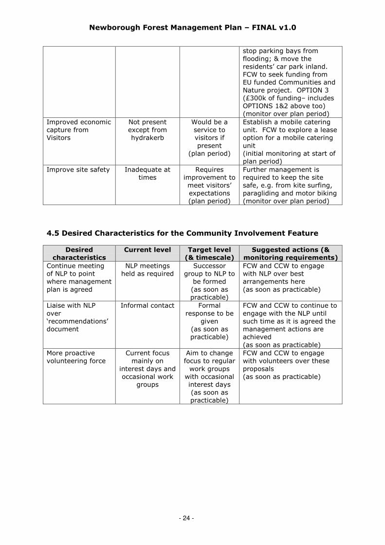
stop parking bays fromflooding; & move theresidents’ car park inland.FCW to seek funding fromEU funded Communities andNature project. OPTION 3(£300k of funding– includesOPTIONS 1&2 above too)(monitor over plan period)
Improved economiccapture fromVisitors
Not presentexcept fromhydrakerb
Would be aservice tovisitors ifpresent
(plan period)
Establish a mobile cateringunit. FCW to explore a leaseoption for a mobile cateringunit(initial monitoring at start ofplan period)
Improve site safety Inadequate attimes
Requiresimprovement tomeet visitors’expectations(plan period)
Further management isrequired to keep the sitesafe, e.g. from kite surfing,paragliding and motor biking(monitor over plan period)
4.5 Desired Characteristics for the Community Involvement Feature
Desired
characteristics
Current level Target level
(& timescale)
Suggested actions (&
monitoring requirements)
Continue meetingof NLP to pointwhere managementplan is agreed
NLP meetingsheld as required
Successorgroup to NLP to
be formed(as soon aspracticable)
FCW and CCW to engagewith NLP over bestarrangements here(as soon as practicable)
Liaise with NLPover‘recommendations’document
Informal contact Formalresponse to be
given(as soon aspracticable)
FCW and CCW to continue toengage with the NLP untilsuch time as it is agreed themanagement actions areachieved(as soon as practicable)
More proactivevolunteering force
Current focusmainly on
interest days andoccasional work
groups
Aim to changefocus to regularwork groups
with occasionalinterest days(as soon aspracticable)
FCW and CCW to engagewith volunteers over theseproposals(as soon as practicable)

Newborough Forest Management Plan – FINAL v1.0
- 25 -
4.6 Desired Characteristics for the Geology & Geomorphology Feature
Desired
characteristics
Current level Target level
(& timescale)
Suggested actions (&
monitoring requirements)
Protect vulnerablegeologicalspecimens
Permissions totake samples are
refused
Continue torefuse
permissions(immediate)
FCW to monitor this withinNewborough Forest and toliaise with CCW & IoACC forconsistency with YnysLlanddwyn(monitor over plan period)
Coastal processesoperating withoutconstraints
Constrained byforest, car parks
and over-development ofdune vegetation
95% of SACcoastal frontageunconstrained.Exceptions forcar parks,roads etc.
(plan period)
(CCW to monitor at 5-yearintervals to coincide withmanagement plan renewalperiod)
Improveinterpretation
Inadequate,especially on
geomorphology
Improved(plan period)
FCW to make bid for funds(monitor over plan period)

Newborough Forest Management Plan – FINAL v1.0
- 26 -
SECTION 5: GENERAL APPROACH TO MANAGING EACH FEATURE
5.1 General Approach to Managing the Forest Feature
5.1.1 Vision for the Forest Feature
• Manage the forest feature for a range of benefits, social, environmental andeconomic, and manage it to increase its resilience to the possible effects of climatechange.
• Maintain a large core area of woodland and manage this for increased diversification,both structurally (through thinning) and species composition (through planting andnatural regeneration).
• Enable more shifting dunes between the sea and the forest along the western edge ofthe forest and south-eastern corner. Only dangerous trees to be removed from theremainder of the southern seaward edge of the forest in this initial plan period.
• Increasing species diversity will move the composition of the forest towards anAtlantic dune woodland in line with the UKBAP.
• Ensure connectivity within the forest canopy to facilitate the movement of redsquirrels, provide sufficient food sources for reds and control greys.
• Continue to consider the roosting sites of the various bat species and the populationof roosting ravens, although the latter is currently declining rapidly in number.
• The forest will be managed to increase its resilience to climate change.
CCW has advised that in order to comply with Article 6.1 of the EC Habitats Directive andto achieve favourable conservation status over the wider area of the Abermenai toAberffraw Dunes SAC, the trees in a limited area of Newborough forest need to beremoved. This is to restore a natural dune zonation behind the shoreline and addressthe perceived impacts of the forest on the hydrology of the designated habitats.
The Newborough Forest science review is currently in arbitration and the followingactions are given solely to provide an indication of what might be appropriate after thereview. Note once again that this is not intended to anticipate or prejudge the outcomeof the review in any way. The following actions may be appropriate:
• Fell 50 to 100 metres along the forest-warren boundary to addresslandscaping and hydrological concerns (this is subject to further consultation).
• Fell a small area of circa 4ha as part of a hydrological experiment onceadequate scientific rigour has been applied to the methodology. This area may beincorporated within the forest-warren landscape felling but is acknowledged thatthe objectives of these two operations are potentially separate and would only becombined if there were obvious synergies from doing so.
• Fell the 22.5 hectares of shoreline felling previously identified in a draft ForestDesign Plan (comprising 17.2ha along the western seaboard and 5.3ha in the bottomsouth-eastern corner) to begin the remobilisation of this section of dune if required.The results of these fellings – only to be carried out if supported by the sciencereview – would be monitored before any further amendments were made to the plan.These proposed clearfells are along the seaboard as these are the areas most likelyto respond to increased sand dune mobilisation. Zone 1 is of particular interest tohydrologists due to its proximity to Newborough Warren.
Again, as stressed above, none of these areas will be scheduled for felling until thescience review has concluded and these actions are supported. These proposals are onlysuggested as a possible means of addressing CCW’s concerns proportionate to thepresently perceived level of risk pending availability of more reliable scientific data.
The proposed areas of felling can be found in Figure 5.1 below, which together representapproximately 4% of the forested area at Newborough.

Newborough Forest Management Plan – FINAL v1.0
- 27 -
Figure 5.1: Proposed areas of clearfelling and pre-emptive underplanting
Key
Zone Description
1* Clearfell and partial destumping. Encourage natural processes.2* Realignment of forest boundary with the warren (indicative felling edge)3* Low-intervention. Monitor and review over the plan period4 Natural processes to be allowed to occur. Area of limited intervention.5 Forest protection. Underplant to create an Atlantic dune woodland (ADW).
*Subject to the conclusion of the Newborough Forest Science Review 2010
The area within the purple line (Zone 5) in Figure 5.1 above is the indicativeunderplanting zone of transition, which represents the point from where the remainingforest inland will be protected. This zone follows some ride features on the ground in thewest, avoids areas already understocked and therefore potentially unsuitable for furtherplanting, runs beyond the road linking the main car park with the residents’ car park,and links in with the original proposed area of clearfelling in the south-eastern corner.This zone has been selected for its practicality on the ground, but note that not all areaswill be planted. Dune slacks and potential dune slacks within this area deemed to haveconservation value for their open space will be left, as will areas of the rock ridge so thatoutcrops which have become valuable landscape features are not obscured. The exactboundaries of Zone 5 may be redefined once the science review has concluded.
Areas of clearfelling to restore to mobile dunes*Realignment of forest boundary with warren* = proposed area of hydrological experiment*Pre-emptive planting of ADW species as buffer against dune incursion

Newborough Forest Management Plan – FINAL v1.0
- 28 -
The original areas of red (Zone 1) in Figure 5.1 are the potential clearfelling coupes thatwill be scheduled for felling only once WAG is content with the conclusions of this aspectof the science review. It is anticipated that no felling will be carried out here untilunderplanting work has started in the forest protection area (Zone 5). The remainingarea (Zone 3) between Zones 1 & 5 will be monitored for natural sand duneremobilisation following any felling and decisions made about any intervention when thismanagement plan is subsequently reviewed. During the plan period only dangeroustrees will be removed in Zone 4 and intervention will be limited to reducing dangerouscliffing of the dunes. If in the longer term a sufficient range in the natural dune profile(particularly in Zone 1 but also in Zones 3 & 4) is not considered to be forming then theoption to fell further areas of dune currently fixed by the forest within this middle zonewill be revisited. All of this is dependent on the outcome of the science review.
5.1.2 Rationale for the Objectives for the Forest
At present 93% of the forest consists of a single species, Corsican pine (see Appendix 1,Figure 1), which does not regenerate freely and is susceptible to red band needle blight(RBNB), a disease caused by the fungus Dothistroma septosporum. The damage thisdisease has already caused and has the potential to cause is giving rise to great concernat present and has resulted in a moratorium on the further planting of Corsican pineacross the United Kingdom. Many other pine species look as if they might be similarlysusceptible, but two pine species, maritime pine (Pinus pinaster) and Macedonian pine(Pinus peuce), appear to be more resistant and may have some potential here (seeAppendix 4 for more details).
Climate change predictions suggest a high risk of pest and disease impacts, with existingpests and diseases potentially becoming more severe and new ones becomingestablished. Such attack can lead to reduced growth or even the complete removal ofsome tree species, so increasing tree species diversity is a necessary adaptationmeasure to this potential threat. Regular surveillance is essential to identify damage atan early stage and to allow suitable management to take place.
Newborough Forest is also structurally poor with 65% of the forested area planted in a15-year period (see Appendix 1, Figure 3). Key actions are therefore to introducefurther species of tree and shrub and to increase structural (age) diversity. Thepresence of RBNB removes the option of planting further Corsican pine, a species thathad been so well suited to these conditions, so whatever is planted will similarly need tobe able to grow well on sand and to be tolerant to salt. A list of potential species to plancan be found in Appendix 4. As red squirrels are a desired component of the forest anyreduction in planting pine species will have some impact on food supplies, but this canbe counter-balanced by providing additional food from other trees and shrubs togetherwith maintaining the current zero policy on grey squirrels. The tree species selected alsomust not have adverse ecological impacts, such as being vigorous colonisers,threatening open areas within the forest or understorey, or impacting on the adjacentopen warren. Invasive species such as Himalayan cotoneaster (Cotoneaster simonsii)can rapidly colonise the shrub layer to the exclusion of native species and make someareas impenetrable. Control of this and other invasive species such as white poplar(Salix alba), Montbretia, swamp stonecrop and tor-grass needs to be carried out usingboth mechanical and chemical treatments. Although the value of Cotoneaster for foodfor birds is recognised there is a strong need to control this invasive species. There willhowever always be some autumn food available for birds from the areas of Cotoneasternot controlled within any given season.
Adopting the above factors should considerably increase the forest’s resilience to climatechange but this does not answer the question of how fast this change process should

Newborough Forest Management Plan – FINAL v1.0
- 29 -
occur. The long-term projections involved in climate change modelling make it difficultto provide accurate predictions of the likely outcomes from climate change scenarios, butit is the long-term nature of forestry itself that makes the early adoption of thisdiversification policy so important. Further management plan revisions will allow themanagement strategy of increasing species and age diversity to be monitored andadapted as required.
Catastrophic events such as windblow may become more frequent, and althoughcontinuous cover forest management may help to reduce these impacts there will be aneed to deal with unforeseen impacts on the forest. The coastline is likely to be affectedby sea level rise, which may not occur in a linear fashion rather the complex dunetopography may cause sudden and significant changes to the degree and impact ofinundation by water. Studies also indicate that a moderate retreat of the shorelineinland over the course of the 21st century is likely. The main focus of managementtherefore will be to ensure that the forest is resilient to change but will accommodatenatural change events when these happen.
The forest also has a role in contributing to climate change mitigation, sequesteringcarbon in its timber for use in construction (long-term removal of carbon from theatmosphere) or for biomass (immediate impact as a substitute for fossil fuels).Compared with the other services the forest provides, such as biodiversity conservationand recreation, carbon sequestration may not seem a major benefit, but as the mostextensive area of forest on Anglesey it does nevertheless provide an importantcontribution in mitigating against climate change.
5.1.3 Securing the Forest
Our overriding objective in the management of Newborough Forest therefore is to securethe forest over the longer term so that a wide range of benefits can be achieved fromthe forest over time. Low impact silvicultural systems (LISS) will be used as an initialmeasure to create structural diversity. Increased species diversity will arise where newspecies of tree and shrub are introduced, whether from underplanting or where ‘gaps’ inthe existing crops are restocked following the creation of ‘holes’ in the canopy. Suchplantings are likely to be considerably smaller in size than the clearfelled areas of thepast. Where RBNB is assessed as a likely problem then ‘crown thinning’ will beundertaken to remove the ‘sub-dominants’ and any clearly diseased trees, and to openup the crop to allow increased airflow. This increase in air circulation is expected toreduce the impact of RBNB but will be done in such a way as to maintain canopyconnectivity for red squirrels to move around above ground level. Crown thinning alsoenables more light to reach the understorey and forest floor encouraging regenerationand aiding underplanting, but this will take place in a controlled way to limit the growthof bramble (Rubus fruticosus) in particular. Although extensive growth of bramble cansmother new planting, in smaller amounts this can protect young trees as well as beinga useful food source for red squirrels.
Where RBNB is assessed as ‘not present’ an irregular shelterwood system of LISS will beused where gaps no larger than 0.25ha, but more typically around 0.1ha in size, will becreated and planted with suitable species depending on objectives. No further gaps willbe created (typically on a 5-year cycle) adjacent to existing gaps until those gaps areestablished and canopy connectivity re-established. Approximately 100 hectares offorest per year will be thinned on average.
5.1.4 Environment
Maintaining over 600 hectares of forest with sufficient canopy connectivity shouldprovide a sufficiently large habitat for red squirrels. Although research carried out by
Newborough Forest Management Plan – FINAL v1.0
- 30 -
Forest Research into creating the best conditions for red squirrels over greys hashighlighted the need to minimise the numbers of large-seeded broadleaves the presentwork of the Anglesey Red Squirrel Project (ARSP) in eradicating greys is another way totackle this issue and is especially appropriate on an island. The list of tree species to beplanted (see Appendix 4) contains both native and non-native species and given thepolicy in the Woodlands for Wales Strategy 2009 for increased species diversity everyopportunity will be taken to plant as wide a range of species as possible. The treespecies to be planted in Newborough Forest need to be able to withstand and prosper inthe extreme prevailing conditions, but increasing the numbers of tree species andencouraging greater structural diversity will also assist in habitat and food sources forother species, including bat species and ravens. The UKBAP target for Atlantic dunewoodland will also be considered here (see Appendices 3 & 4).
Further consideration will be given to designating an area of natural reserve at a futurepoint, but not within the period of this plan. Areas of natural reserve are an importantaspect of good forest management and UKWAS requires a minimum of 1% of the forestestate to be so designated, but this is not a requirement of individual forests within thewider estate. The need to diversify the species and structural composition of the forest,the number of invasive species (from grey squirrel to tor-grass and Cotoneaster, all ofwhich require intervention), and the need to manage high levels of public recreationmake this designation unsuitable at present.
Areas of open space will provide suitable habitat for species such as shore dock (whichrequires a dynamic mobile landscape), medicinal leech, great crested newts (which onlyrequire small amounts of open space) and a number of dune plants. These areas will bekept clear of scrub vegetation. Recent studies have demonstrated the importance ofmaintaining open, scuffed, bare areas of sand in Newborough Forest for invertebrates.Where possible, open unplanted areas will be extended and joined to provideconnections between these patches, and possibly also with the open warren and the foredunes. The existing open slacks within the forest will be allowed to flood in winter andany drains that currently take water away from these areas will be blocked and thewater table levels monitored to assess any impacts the forest might be having here.
The thinning programmes referred to in Section 5.1.3 above will allow attention to begiven to the micro-design of the forest. Opportunities will be taken to break up the walleffect of the forest alongside public roads, forest roads and trails, also along long linearfeatures such as the forest-warren boundary (the exact felling boundaries of which arestill to be determined). The open areas so created will be maintained as open areasalong with the open areas in glades and in wider rides.
5.1.5 Heritage
The heritage features within the forest are well mapped and have agreed workprogrammes to keep them free from scrub encroachment.
5.2 General Approach to Managing the Sand Dunes Feature
5.2.1 Vision for the Sand Dunes Feature
• The areas of fixed dunes presently to be found on sections of the seaward edge, inparticular the western seaward edge, to be exposed to more natural processesallowing for improved representation of a more complete dune system over more ofthe SAC coastline.
• Felling will take place over a limited area with a protected transition zone of newlyestablished forest and scrub to establish a more wind-firm and robust tract of trees.
Newborough Forest Management Plan – FINAL v1.0
- 31 -
• Parts of the forested coastline will be left to natural processes where limitedintervention will keep this area safe for visitors. The changes will be monitored andactivity reviewed to ensure the dune habitat meets the required conservationcondition for this designated habitat.
5.2.2 Rationale for the Objectives for the Sand Dunes Feature
CCW has advised FCW that this habitat is presently in an unfavourable condition becausethe required range of zones from embryonic dunes through yellow dunes to fixedgrassland is not present along the required 95% of the SAC frontage. The SAC coremanagement plan gives the reason for this as the forest truncating the zonation andsuggests restoration of the natural zonation by restoring ‘embryonic shifting dunes’,‘shifting dunes along the shoreline with Ammophila arenaria’ and ‘fixed dunes withherbaceous vegetation (grey dunes)’. The NFP and CCW have debated the definition of95% zonation as part of the science review and whether this should apply to the wholesite or just the part of the site already exhibiting zonation, and have been unable toreach a consensus view. The calculation in Section 1.3.1 (page 7) above has been doneover the entire length of the SAC coastline to put the forest in perspective. 30% of the
windward SAC coastline is backed by coniferous forest.
Subject to the outcome of the science review if the seaward areas identified for fellingare felled then some existing stumps will be removed on selected windward faces ofdunes. A degree of mechanical stirring of the sand will also be inevitable, but note thatthere is no intention to carry out major sand engineering works here.
The core management plan states that ‘fixed dunes with herbaceous vegetation (greydunes)’ and ‘dunes with Salix repens ssp. argentea (Salicion arenariae)’ require lightgrazing to maintain open conditions. While this is not yet appropriate within the areas ofclearfelling referred to in Section 5.1.1 above there are other parts of the forest wheregrazing is appropriate as a management tool. Grazing will continue to be used within adefined and agreed programme in areas such as Canada Pool and Dune Slack Pool andwithin areas of the forest where rough herbage is to be controlled.
The SAC core management plan notes that a restored water table would assist in themanagement of the ‘dunes with Salix repens ssp. argentea (Salicion arenariae)’. It istherefore proposed that existing slacks within the forest be further monitored, includingPandy Slack, Parnassus Slack, Dune Slack, Gullery, Brown Moss Bog and two furtherunnamed slacks, and that drains are blocked to raise the level of the water table in theseareas. Maps of these areas can be found in Figure 6.5 (on page 47).
Artificial structures such as car parks and their access roads can also restrict naturalprocesses. Where these are strategically important – for example the main beach carpark and its access road, and the residents’ car park and its linking road – they will bekept functioning as far as possible without major intervention. Proposals are containedin this plan for a landward development of the main beach car park and to move theresidents’ car park further inland. Natural processes will not be restricted at TraethPenrhos, where some sand dune restoration is to be undertaken, so the road there maybecome buried by sand.
The Newborough Liaison Partnership (NLP) has expressed a desire to see greaterintegration of landscape and habitats, and one area in particular where the contrastbetween closed and open is especially marked is along the forest-warren boundary. Theoriginal intention had been to create small scallops along the linear boundary betweenforest and warren but this will now be replaced with the hydrological felling identified inSection 5.1.1 (page 27) above.

Newborough Forest Management Plan – FINAL v1.0
- 32 -
5.3 General Approach to Managing the Shore Dock Feature
5.3.1 Vision for the Shore Dock Feature
• Bring shore dock to a favourable conservation status, where all of the followingconditions are satisfied:
• The population of shore dock to be stable or increasing (stream sites A & B ≥ 70individuals; pond site ≥ 30 individuals).
• Shore dock to occur in at least 3 locations across the site (stream sites A & B andpond site).
• Some opportunities to be created for the dispersal of seed if this is possible.• Maintain adequate habitats – open streamsides, coastal soft cliff seepages or
dune slack pool habitat – for its survival.• Maintain an adequate freshwater supply.• Maintain bare ground or disturbed areas (e.g. by grazing animals) to permit
germination.• Control competition (including shading) from other species (no Phragmites or
scrub or overhanging trees).• Control all factors affecting the achievement of the above conditions.
Shore dock requires bare ground for seed to germinate. This can be provided throughnatural erosion or livestock poaching.
Figure 5.2: Shore Dock Locations
5.3.2 Rationale for the Objectives for Shore Dock
The successful management of shore dock requires habitat maintenance and restorationmanagement. Because of lack of knowledge on the genetic diversity of the Newboroughpopulation conservation work will concentrate on habitat improvement and maintenancearound the extant populations and adjacent areas of potential habitat (e.g. Dune SlackPool).
Habitat Management.
For all three sites the required disturbance is not presently happening because thepopulations are located deep within the conifer forest and away from areas exposed to
Newborough Forest Management Plan – FINAL v1.0
- 33 -
natural erosion. Each of the three locations has in the past shown signs of becomingscrubbed over. In order to create disturbance a grazing regime will be established at thestreamside locations. This will be done at the pond site by hand or machine as part ofthe annual work programme.
The hydrology characteristic is fulfilled at all three locations as fresh water is available,although there is a lack of lateral movement at the pond site as the pond is fed bynatural seepage. The water quality characteristic is fulfilled at all three locations. Itmay be helpful to increase the relative proportion of broadleaves in the canopy aroundthese sites to assist the water regime.
5.4 General Approach to Managing the Recreation Feature
5.4.1 Vision for the Recreation Feature
• Maintain the access and recreational uses that are currently permitted and acceptedin the forest and improve them where possible.
• The forest will have open access on foot to those areas where management permits;this will include all-ability access to enable everyone to experience the uniquecharacteristics of the site.
• The forest will continue to provide some shelter to beach users to maintain theparticular attraction of this site.
• Paid vehicular access will be provided to the beach car park and for the residents ofNewborough to the residents’ car park by permit.
• Recreation management will help minimise conflict between users of the forest.There will be waymarked routes and interpretation of the site will be aided by theprovision of suitable information about to the site. FCW will improve local and visitorknowledge of access routes and facilities at Newborough in a way that is compatiblewith maintaining the quiet, wild nature of the area.
• The Blue Flag Beach status will be supported.
5.4.2 Rationale for the Objectives for the Recreation Feature
Recreation at Newborough Forest is an extremely important feature of the site and onewhich has been successfully managed up to this point. Recreation is important atNewborough because the forest offers the opportunity for a wide range of recreationalactivities in a peaceful and tranquil environment that can hold large numbers of peoplewhilst providing a feeling of isolation. On stormy days it offers shelter and on calm daysit acts as the gateway to a majestic beach. The proximity of forest, beach and sea isimportant to those who use it. Any recreation management must retain thesecharacteristics and not compromise them.
Recreation management will ensure that the site remains an attractive destination forvisitors, whether local or from afar, and that facilities are provided such as access, carparking and waymarked trails with appropriate interpretation.
Open access on foot throughout the forest will be encouraged, and in those areas wherethis is not possible, for example where livestock is grazing, appropriate discreet signagewill be provided. Public motorised access will only be permitted along the access roadbetween the Hydrakerb and the beach car park and by permit for local residents to theresidents’ car park.
FCW will maintain the access and recreational uses that are currently permitted andaccepted on the site and improve them where possible through improved micro-designof the forest and annual assessments of their condition and their ability to cater for all

Newborough Forest Management Plan – FINAL v1.0
- 34 -
abilities. Where there are currently deficiencies, such as in the provision of all-abilityaccess, action will be taken to correct this.
FCW will not look to develop dedicated mountain bike facilities within the forest asNewborough is not identified as one of the centres within the FCW Mountain BikeStrategy, rather it is believed that the numerous forest roads provide excellent familymountain bike experience and link in with the Lon Las Cefni Bike Trail.
Actual conflicts between different recreational uses - or indeed with antisocial uses too –are rare (e.g. between horse riding and mountain biking, or kite surfing and family beachuse, or all-night use of the beach car park). Where conflicts or antisocial usage areidentified management actions will be put in place to deal with these (e.g. by providing adedicated barbecue area to discourage associated fire risks in other areas of the forest).
Interpretation is an important aspect of the recreation experience and one that requiresimprovements within the forest and dunes. A dedicated interpretation plan will beproduced in partnership with CCW. Improved interpretation could also add value acrossthe range of archaeological features and the protected species and habitats present onthe site.
Congestion in the village on certain weekends caused by the beach car park being fullneeds to be addressed. FCW will put forward proposals to expand the capacity of thebeach car park whilst not expanding its footprint. There is potential for this to berelocated inland to free up the coastal zone.
The local community considers there is currently little direct economic benefit derivedfrom Newborough Forest but there is scope for local enterprises to benefit economicallyfrom the large numbers of users of the forest, particularly through the provision ofaccommodation, food, hire of mountain bikes, and so on. There is potential for RhosyrCommunity Council together with FCW, CCW and Menter Mon to develop a strategy forsustainable economic development. Contact will be made with Isle of Anglesey CountyCouncil’s (IoACC) Economic Development Unit to assist with their work on a coastalfootpath strategy for economic development.
There have been discussions recently regarding a possible visitor centre in theNewborough area. There are no firm proposals on the table but a feasibility study hasbeen undertaken. This suggestion is looking unlikely in the present economic climate.
An established procedure exists for issuing permissions within the forest for activitiesother than pedestrian access (which is permitted under Countryside & Rights of Way Act2000). The permissions procedure controls access to the forest for larger events andrepeat activities. Permits for horseriding are issued through the Newborough RidingAssociation.
5.5 General Approach to Managing the Community Involvement Feature
5.5.1 Vision for the Community Involvement Feature
• FCW and CCW to continue to liaise with local stakeholders (for now through the NLP)and to consider the issues raised, also to continue to respect local issues and providea means for views to be expressed.
• FCW & CCW to act on the recommendations set out in the NLP report and ifundeliverable provide justification and dialogue.
• The forest to meet a wide range of objectives that contribute to local environmental,economic and recreational interests.
Newborough Forest Management Plan – FINAL v1.0
- 35 -
• The community to continue to play an important role in educating others anddisseminating knowledge about the forest.
• The local community to retain its preferential access to the beach through theresidents’ car park and access road.
• The village not to suffer negatively from any traffic congestion as a result of thebeach car park being full.
• No sand to blow into the village of Newborough.
5.5.2 Rationale for the Objectives for the Community Involvement Feature
Continued effective community involvement in the management of Newborough Forest isextremely important. A large proportion of the local community uses the forest on adaily basis, has an active interest in its management or a deep knowledge of its pasthistory. Experience has shown that it is essential for the community to be involved notjust in the decision-making process but also in the management of the forest.Community involvement will therefore be central to the management of the forestthrough the community council and NLP, or the latter’s successor forum onceestablished.
The community and others have expressed through the NLP what they value about theforest and the future developments they would like to see. FCW recognises the effortthat has gone into the development of the NLP recommendations and has incorporatedthese where possible into this management plan. FCW will always seek to avoidcompromising any aspect of the forest’s special characteristics of tranquility, beauty,shelter, feeling of isolation, recreation opportunities in all weathers, close proximity ofsea, beach and forest, walks and paths and open access on foot. If it is felt that this isunavoidable then justification will be given.
The residents’ car park with its associated access is historically important to thecommunity and FCW will retain this facility; however the natural shoreline erosion that isundermining the current car park will eventually force its relocation back from the beach.Proposals are included in this plan to relocate this car park to the barrier at the junctionwith the residents’ access road.
Preventing sand incursion into the village was one of the original reasons for plantingNewborough Forest and FCW will ensure that the forest continues to deliver thisobjective by identifying strategically important parts of the forest. It is noted that sandincursion is not a significant problem behind the open sand dunes and the sand incursionthat occurred in the 1940s and ‘50s is now thought to be much less likely.
On certain days, usually during the summer or on bank holidays, the beach car parkdoes not have enough capacity to accommodate all the visitors wishing to use it. Onthese occasions the traffic can back up all the way to the crossroads in the village andcause congestion. Proposals will be developed which seek ways to avoid this happeningin the future.
Newborough Forest Management Plan – FINAL v1.0
- 36 -
5.6 General Approach to Managing the Geology & Geomorphology
Feature
5.6.1 Vision for the Geology and Geomorphology Feature
• The physical composition, morphology and internal structure of the key landformsand sediments to remain intact and undisturbed by human interventions.
• Natural geomorphological processes to be unimpeded as far as possible, the levels ofactivity of these processes and their spatial domain to have the capacity to operateacross their full range of natural variability.
• The extent of the key geomorphological features not to be diminished throughphysical damage or fragmentation.
• The small area of the rock ridge between the isthmus and the forest road is a GCR(Geological Conservation Review) feature and to continue to be given the highestdegree of protection; the rest of the ridge is a Regionally Important Geological Site(RIGS), which will also be protected.
5.6.2 Rationale for the Objectives for Geology and Geomorphology
The coastal landforms should demonstrate the natural processes of sediment transferand deposition within the local coastal system. These geomorphological processes(which move sand and mud to create beaches, dunes, slacks and estuarine flats) alsocreate the physical template upon which biological features develop. These processeswill be aided by minimising any activities or structures that would interrupt the naturalmovement of sediment and directly or indirectly cause damage to coastal landforms.
Natural erosion of the bedrock on Ynys Llanddwyn is negligible and has no effect on thesite interest. Natural movement of sand in the vicinity of the island leading to thecovering of rock will be tolerated. Movement of sand by coastal processes may revealnew exposures around Gwddw Llanddwyn and further inland, but note that most of thegeological interest here lies outwith the Newborough Forest management boundary. Ifnew exposures do arise these will need to be mapped and may reveal fresh examples ofminerals which are depleted elsewhere.
Mineral and specimen collecting is a major threat to the geological interest on YnysLlanddwyn and adjacent areas and there is a presumption against collecting geologicalspecimens within the Newborough Forest management boundary. Visiting geologistsshould not be allowed to use hammers or drills in the forest and adjacent beachoutcrops. As many universities already have specimens and sections from this areathere will be a presumption against further collection unless demonstrably for newresearch.
Scrub will not be allowed to develop on the rock ridge and as thinning takes placearound this feature the opportunity will be taken to draw back the tree cover whereappropriate.
FCW will work with CCW to develop interpretation of the landforms and geology toensure that there is a wider appreciation in this area. FCW will also link in with theGeoMôn project, which aims to promote the geological diversity of Anglesey and has won‘Geoparc’ status for the island. GeoMôn is developing a number of initiatives to developinterpretation, education, conservation and appreciation of the geological heritage of thearea. It also aims to increase economic activity within Anglesey through ‘geotourism’.

Newborough Forest Management Plan – FINAL v1.0
- 37 -
SECTION 6: OPERATIONAL PRIORITIES FOR MANAGING EACH FEATURE
The majority of the recommendations from the NLP report 2006 will be found under the
sections on Recreation Feature and Community Involvement Feature (Sections 6.4 & 6.5
respectively) below.
6.1 Proposed Actions for the Forest Feature
ACTIONS RELATING PRIMARILY TO PEOPLE
AP 6.1.1: Undertake tree safety checks throughout the forest to maintain public safety.Target within 1 year: Checks initially to focus on main roads and trails within theforest and to follow the procedures contained within FC internal document OGB1.Monitoring activity: Checks to be carried out annually.Timescale (start/duration): Within a year / Plan period.
AP 6.1.2: Any trees that are removed along the shoreline in Zone 4, for example forsafety reasons, will not result in a new linear tree line, rather the opportunity will betaken to follow contours and link in with fixed assets such as the car parks. As few treesas possible will be taken. NLP Recommendation No. D.1(ii).
The following extract map from Figure 5.1 shows Zone 4, which lies between thesouthern foreshore and the forest road between the main beach car park and theresidents’ car park.
Target within 1 year: Carry out regular visual assessments along the forest roadbetween the main beach car park and the residents’ car park and along the beachfront.Monitoring activity: Reassess at same time each year thereafter.Timescale (start/duration): Within a year / Plan period.
AP 6.1.3: Agree an education strategy for the forest and organise interpretation andeducation activities to increase understanding of both the forest and the warren. NLPRecommendation No. B.1(ii).Target within 1 year: Agree terms of reference for a strategy in liaison with the FCWeducation team and CCW.Monitoring activity: Check progress with this annually.Timescale (start/duration): Within a year / Plan period.
ACTIONS RELATING PRIMARILY TO THE ENVIRONMENT
AP 6.1.4: All dune habitat restoration will be managed to fit in with the natural patternof sand dune zonation. NLP Recommendation No. D.1(iii). The areas most likely tobe affected by this action point are the two areas of clearfell in Zone 1, although thiswork will only be carried out following the outcome of the science review.
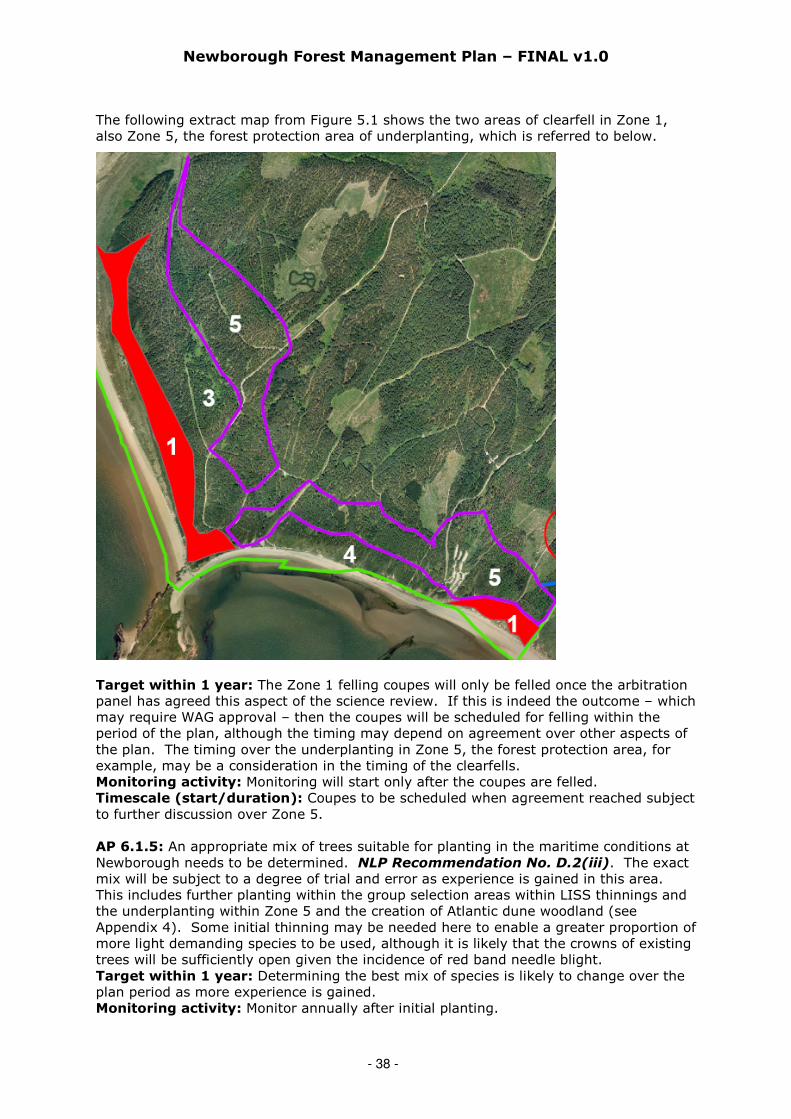
Newborough Forest Management Plan – FINAL v1.0
- 38 -
The following extract map from Figure 5.1 shows the two areas of clearfell in Zone 1,also Zone 5, the forest protection area of underplanting, which is referred to below.
Target within 1 year: The Zone 1 felling coupes will only be felled once the arbitrationpanel has agreed this aspect of the science review. If this is indeed the outcome – whichmay require WAG approval – then the coupes will be scheduled for felling within theperiod of the plan, although the timing may depend on agreement over other aspects ofthe plan. The timing over the underplanting in Zone 5, the forest protection area, forexample, may be a consideration in the timing of the clearfells.Monitoring activity: Monitoring will start only after the coupes are felled.Timescale (start/duration): Coupes to be scheduled when agreement reached subjectto further discussion over Zone 5.
AP 6.1.5: An appropriate mix of trees suitable for planting in the maritime conditions atNewborough needs to be determined. NLP Recommendation No. D.2(iii). The exactmix will be subject to a degree of trial and error as experience is gained in this area.This includes further planting within the group selection areas within LISS thinnings andthe underplanting within Zone 5 and the creation of Atlantic dune woodland (seeAppendix 4). Some initial thinning may be needed here to enable a greater proportion ofmore light demanding species to be used, although it is likely that the crowns of existingtrees will be sufficiently open given the incidence of red band needle blight.Target within 1 year: Determining the best mix of species is likely to change over theplan period as more experience is gained.Monitoring activity: Monitor annually after initial planting.

Newborough Forest Management Plan – FINAL v1.0
- 39 -
Timescale (start/duration): As soon as possible within the plan period / Plan period.
AP 6.1.6: Explore the potential for the forest as a carbon sink. NLP RecommendationNo. D.2(vi).Target within 1 year: To be considered as part of a wider exercise for the FD usingForestry Commission Information Note 48, ‘Forests, Carbon and Climate Change: the UKContribution’. The use of the new FC pilot ‘Woodland Carbon Code’ (2010) in assistinghere will be investigated.Monitoring activity: Monitor as part of annual UKWAS audit.Timescale (start/duration): Within a year / Maintain records for plan period.
AP 6.1.7: Engage with Local Biodiversity Action Plan (LBAP) and Local GeodiversityAction Plan (LGAP) contacts (including the IoACC Biodiversity Officer) for monitoringresults of action plans (see Appendix 3).Target within 1 year: Develop a species monitoring plan and agree the frequency ofmonitoring required for key species with the Local Record Centre (LRC).Monitoring activity: Annually or as appropriate (with assistance from expertvolunteers).Timescale (start/duration): Within a year / Plan period. Report back to LBAP / LRC.
AP 6.1.8: Further consideration to be given to designating an area of natural reserve inNewborough Forest not now, but as part of the full plan revision in 10 years’ time.Creating Atlantic dune woodland may help to fulfil this objective in years to come.NLP Recommendation No. D.2(v).Target within 1 year: No further action at present.Monitoring activity: No further action at present.Timescale (start/duration): Consider further at end of plan period.
AP 6.1.9: Contribute to the development of a viable red squirrel population on Angleseyin line with relevant strategies. NLP Recommendation No. D.1(iv). FCW will liaisewith the Anglesey Red Squirrel Project to produce a project plan for red squirrels inNewborough that links in with the Squirrel Conservation Plan launched by Jane Davidsonand Elin Jones in February 2010. This project plan will include the requirement for forestmanagement measures (adequate connectivity in the forest and food sources) andadequate control measures (of grey squirrels, with this work being funded and controlledthrough the Anglesey Red Squirrel Project).Target within 1 year: Agree the basis for a project plan with the Anglesey Red SquirrelProject.Monitoring activity: Annually through the Anglesey Red Squirrel Project.Timescale (start/duration): Within a year / Plan period.
AP 6.1.10: Raise the water table to encourage more winter flooding of dune slacks bychanging the existing drainage. NLP Recommendation No. B.1(vii). Up to 3.2km ofdrains within the forest and a further length of drains outside of the forested area on thesaltmarsh will be stopped up to see if this encourages winter flooding within the slacks(highlighted in green in the map below). The blocking of drains and raising water tablelevels is likely to benefit dune slack habitat and aquatic species and vegetation, andshould lead to greater connectivity within the forest. This will benefit aquatic speciesincluding great crested newts, common toad, shore dock and water voles.

Newborough Forest Management Plan – FINAL v1.0
- 40 -
Figure 6.1: Locations of Drains to be Blocked
Target within 1 year: The stopping up of the drains will be scheduled for carrying outwithin the plan period.Monitoring activity: Monitoring to commence once work has been completed.Environment Agency Wales will be involved in the specification of the ditch stoppingwork, also in monitoring to gauge increases in aquatic connectivity within the forest.Timescale (start/duration): Within plan period / Monitor progress annually thereafter.
AP 6.1.11: Survey the forest to determine the extent of invasive species so that anannual programme of work can be devised and implemented. Invasive species toinclude Cotoneaster, sea buckthorn, white poplar, Rhododendron, swamp stonecrop andtor-grass. Plan to cover the entire forest in a five-year rolling programme.Target within 1 year: Survey to be carried out within a year.Monitoring activity: Annually within the business plan timescale.Timescale (start/duration): Within a year of plan approval / Plan period.
AP 6.1.12: Agree and implement a grazing programme with CCW.Target within 1 year: Agree a 5-year grazing programme.Monitoring activity: Annually.Timescale (start/duration): Within a year of plan approval / Plan period.
AP 6.1.13: All archaeological features will be clearly marked on the ground and havetheir own management plans consisting of a simple description of the feature and a briefstatement of management actions. Provide interpretation for at least two archaeologicalfeatures, perhaps at Hendai and Pandy Mill.Target within 1 year: Management plans to be completed within plan period.Monitoring activity: Business plan submissions to be made annually.Timescale (start/duration): First plans within a year / All plans by end of plan period.
ACTIONS RELATING PRIMARILY TO ECONOMIC FACTORS
Note that a separate document titled ‘ANNEX to Newborough Forest Management Plan
v1.0’ is also available on request to inform this section. This annex is not reproduced
here as its size is potentially disproportionate to this main management plan document.
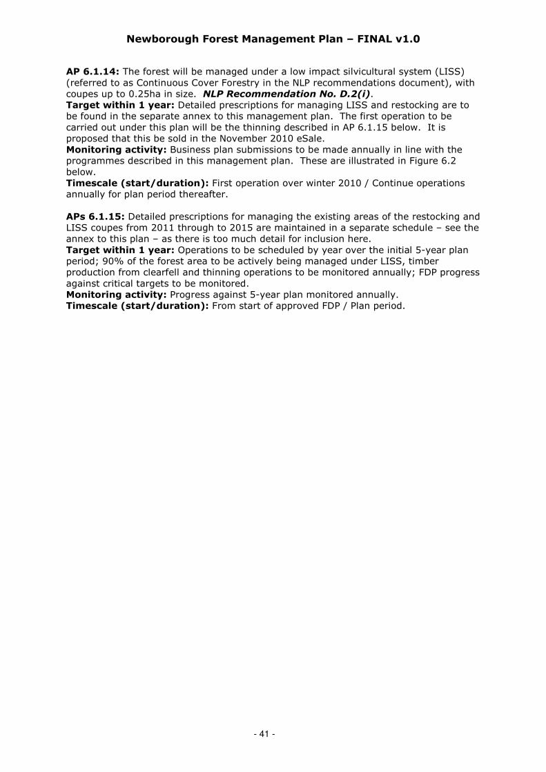
Newborough Forest Management Plan – FINAL v1.0
- 41 -
AP 6.1.14: The forest will be managed under a low impact silvicultural system (LISS)(referred to as Continuous Cover Forestry in the NLP recommendations document), withcoupes up to 0.25ha in size. NLP Recommendation No. D.2(i).Target within 1 year: Detailed prescriptions for managing LISS and restocking are tobe found in the separate annex to this management plan. The first operation to becarried out under this plan will be the thinning described in AP 6.1.15 below. It isproposed that this be sold in the November 2010 eSale.Monitoring activity: Business plan submissions to be made annually in line with theprogrammes described in this management plan. These are illustrated in Figure 6.2below.Timescale (start/duration): First operation over winter 2010 / Continue operationsannually for plan period thereafter.
APs 6.1.15: Detailed prescriptions for managing the existing areas of the restocking andLISS coupes from 2011 through to 2015 are maintained in a separate schedule – see theannex to this plan – as there is too much detail for inclusion here.Target within 1 year: Operations to be scheduled by year over the initial 5-year planperiod; 90% of the forest area to be actively being managed under LISS, timberproduction from clearfell and thinning operations to be monitored annually; FDP progressagainst critical targets to be monitored.Monitoring activity: Progress against 5-year plan monitored annually.Timescale (start/duration): From start of approved FDP / Plan period.

Newborough Forest Management Plan – FINAL v1.0
- 42 -
Figure 6.2: Proposed Thinning Operations by Financial Year*
*Financial year is the year to 31 March from 1 April of the year before. A financial year
of 2011 for example refers to the period 1 April 2010 to 31 March 2011.
Areas of light green in the above map represent thicket stage crops. In due coursethese will be ‘recruited’ to this thinning map and allocated a thinning year.
AP 6.1.16: The forest needs urgent thinning to increase air circulation within the crownsto reduce the impact of red band needle blight (RBNB) but care will be taken to ensureadequate connectivity is maintained in the canopy for red squirrels. The maps of theplanned operations in 2010-11 and 2011-12 are shown below.Target within 1 year: The first thinning parcel (see Figure 6.3 below) to be sold in theNovember 2010 eSale with an immediate start to minimise the impact on breedinganimals (from great crested newts to red squirrels), also so that the timber is notaffected by blue stain fungus.Monitoring activity: By FCW as part of normal operational activity.Timescale (start/duration): Sell in November 2010 / Complete by spring 2011.

Newborough Forest Management Plan – FINAL v1.0
- 43 -
Figure 6.3: Proposed Thinning Operations for 2010-11 & 2011-12
Method statement for the first (2010-11) of the thinning operations above:The aim of thinning this coupe (10041) is to:
• Open up the crop to increase airflow and reduce the incidence of RBNB• Retain as much aerial connectivity as possible for the resident population of red
squirrel (but note that RBNB is a major limiting factor in maintaining connectivity dueto crown dieback).
All trees to be removed by thinning and small-scale group fellings (up to 0.25ha in size),carried out to marginal intensity using predominately feller-selection. Pre-markedsample areas to be used as a guide. Timber to be felled as shortwood.
Compartment 20 a-g to be worked first as this area is ideal to allow the operator tobecome familiar with the prescriptions (i.e. to get their ‘eye in’). All dead and dyingtrees to be removed from the thinning coupe in the first instance.
Sub-compartments d & f were poorly thinned in the past and therefore require rackingand an intermediate thinning within the matrix. The aim is to remove 25% of thevolume from this area, and the same proportion of woodland edge trees.
There is an existing ride that separates these sub-compartments from the rest, which isnot to be used for extraction along its length due to the diversity of existing regenerationof hawthorn, holly, yew and rowan. The ride to be crossed in several places though.
Within Sub-compartments a-c & e there will be more group felling with little or nothinning of the matrix, the aim being to create group fellings of approximately 20 x 20metres (= 0.04 hectares per group). The exact areas felled will depend upon the crop,the topography and existing regeneration, but will be placed with the following factors inmind (in the following order of importance):
• firstly targeting groups of trees that are dead, dying or severely affected by RBNB;
Right: Proposed 2010-11 Thinning(Coupe 10041, 106 hectares)
Below: Proposed 2011-12 Thinning

Newborough Forest Management Plan – FINAL v1.0
- 44 -
• to ‘release’ areas of existing regeneration of any tree species;• within crops of poor canopy connectivity;• lastly within crops of good health where removal is not deemed detrimental to the
aims of the intervention and is evenly spaced away from adjacent groups.
The aim will be to cut three of these group areas per hectare (= 49 m3obs per ha), butthis prescription is flexible and will be determined by nearby group sizes and whetherany of the volume to be removed per hectare has already been removed in the matrix.
Some groups will be created along the fenceline in order to break up the straightness ofthe woodland edge.
Damage to known dipwell sites will be avoided. The locations of the various dipwellsscattered throughout the forest have been provided to FCW.
The timber, after felling, will be extracted to forest roadside, where it will be stackedawaiting dispatch by timber lorry.
No specialised forest machinery is required on this site as it is completely flat and has nosite obstacles; similarly no preparatory civil engineering, such as tracks or roadextensions, is required.
The site will be worked over the winter months to minimise the impacts on fauna. Thepresent draft contract period is set at 1 January 2010 to the end of April 2011 but anearlier start in December 2010 will be encouraged. The individual trees are large at overa cubic metre per tree, and there are no physical obstacles to harvesting.
Staff from the forest district planning unit will maintain a strong initial presence and beavailable to give guidance to operators and site supervisors throughout the initialthinning area. Once Compartment 20 has been thinned the above prescriptions willapply to the remaining thinning coupe area
Figure 6.4: Great Crested Newt considerations with proposed thinning ops
Right: Great Crested Newt considerationswith proposed 2010-11 Thinning
Below: Great Crested Newt considerationswith proposed 2011-12 Thinning
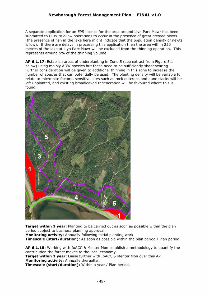
Newborough Forest Management Plan – FINAL v1.0
- 45 -
A separate application for an EPS licence for the area around Llyn Parc Mawr has beensubmitted to CCW to allow operations to occur in the presence of great crested newts(the presence of fish in the lake here might indicate that the population density of newtsis low). If there are delays in processing this application then the area within 250metres of the lake at Llyn Parc Mawr will be excluded from the thinning operation. Thisrepresents around 5% of the thinning volume.
AP 6.1.17: Establish areas of underplanting in Zone 5 (see extract from Figure 5.1below) using mainly ADW species but these need to be sufficiently shadebearing.Further consideration will be given to additional thinning in this zone to increase thenumber of species that can potentially be used. The planting density will be variable torelate to micro-site factors, sensitive sites such as rock outcrops and dune slacks will beleft unplanted, and existing broadleaved regeneration will be favoured where this isfound.
Target within 1 year: Planting to be carried out as soon as possible within the planperiod subject to business planning approval.Monitoring activity: Annually following initial planting work.Timescale (start/duration): As soon as possible within the plan period / Plan period.
AP 6.1.18: Working with IoACC & Menter Mon establish a methodology to quantify thecontribution the forest makes to the local economy.Target within 1 year: Liaise further with IoACC & Menter Mon over this AP.Monitoring activity: Annually thereafter.Timescale (start/duration): Within a year / Plan period.
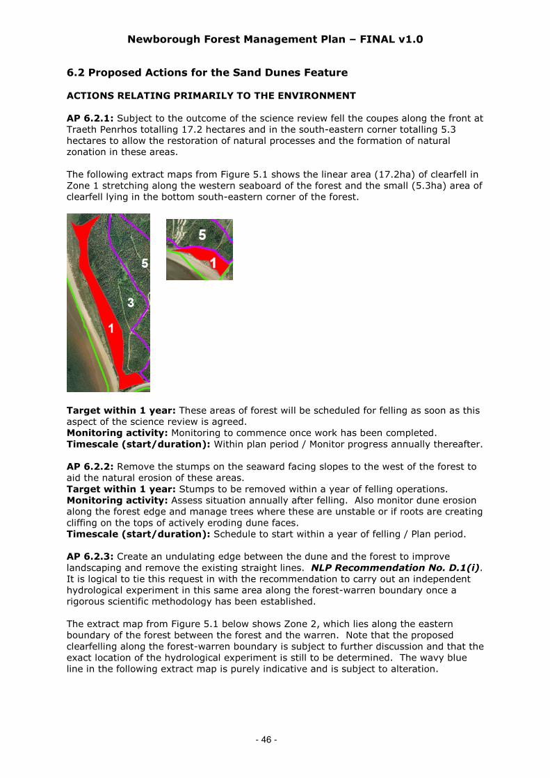
Newborough Forest Management Plan – FINAL v1.0
- 46 -
6.2 Proposed Actions for the Sand Dunes Feature
ACTIONS RELATING PRIMARILY TO THE ENVIRONMENT
AP 6.2.1: Subject to the outcome of the science review fell the coupes along the front atTraeth Penrhos totalling 17.2 hectares and in the south-eastern corner totalling 5.3hectares to allow the restoration of natural processes and the formation of naturalzonation in these areas.
The following extract maps from Figure 5.1 shows the linear area (17.2ha) of clearfell inZone 1 stretching along the western seaboard of the forest and the small (5.3ha) area ofclearfell lying in the bottom south-eastern corner of the forest.
Target within 1 year: These areas of forest will be scheduled for felling as soon as thisaspect of the science review is agreed.Monitoring activity: Monitoring to commence once work has been completed.Timescale (start/duration): Within plan period / Monitor progress annually thereafter.
AP 6.2.2: Remove the stumps on the seaward facing slopes to the west of the forest toaid the natural erosion of these areas.Target within 1 year: Stumps to be removed within a year of felling operations.Monitoring activity: Assess situation annually after felling. Also monitor dune erosionalong the forest edge and manage trees where these are unstable or if roots are creatingcliffing on the tops of actively eroding dune faces.Timescale (start/duration): Schedule to start within a year of felling / Plan period.
AP 6.2.3: Create an undulating edge between the dune and the forest to improvelandscaping and remove the existing straight lines. NLP Recommendation No. D.1(i).It is logical to tie this request in with the recommendation to carry out an independenthydrological experiment in this same area along the forest-warren boundary once arigorous scientific methodology has been established.
The extract map from Figure 5.1 below shows Zone 2, which lies along the easternboundary of the forest between the forest and the warren. Note that the proposedclearfelling along the forest-warren boundary is subject to further discussion and that theexact location of the hydrological experiment is still to be determined. The wavy blueline in the following extract map is purely indicative and is subject to alteration.
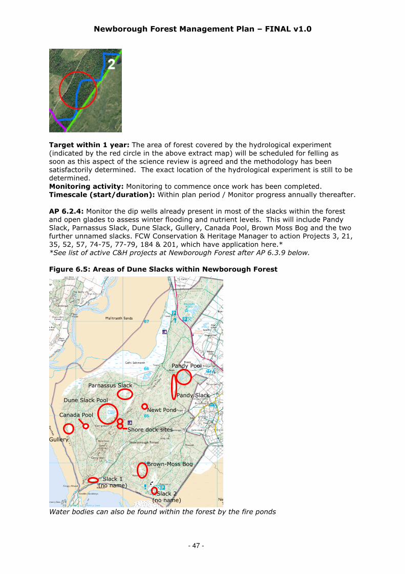
Newborough Forest Management Plan – FINAL v1.0
- 47 -
Target within 1 year: The area of forest covered by the hydrological experiment(indicated by the red circle in the above extract map) will be scheduled for felling assoon as this aspect of the science review is agreed and the methodology has beensatisfactorily determined. The exact location of the hydrological experiment is still to bedetermined.Monitoring activity: Monitoring to commence once work has been completed.Timescale (start/duration): Within plan period / Monitor progress annually thereafter.
AP 6.2.4: Monitor the dip wells already present in most of the slacks within the forestand open glades to assess winter flooding and nutrient levels. This will include PandySlack, Parnassus Slack, Dune Slack, Gullery, Canada Pool, Brown Moss Bog and the twofurther unnamed slacks. FCW Conservation & Heritage Manager to action Projects 3, 21,35, 52, 57, 74-75, 77-79, 184 & 201, which have application here.**See list of active C&H projects at Newborough Forest after AP 6.3.9 below.
Figure 6.5: Areas of Dune Slacks within Newborough Forest
Water bodies can also be found within the forest by the fire ponds
Brown-Moss Bog
Slack 1(no name)
Pandy Slack
Pandy Pool
Newt Pond
Parnassus Slack
Dune Slack Pool
Canada Pool
Gullery
Shore dock sites
Slack 2(no name)

Newborough Forest Management Plan – FINAL v1.0
- 48 -
6.3 Proposed Actions for the Shore Dock Feature
ACTIONS RELATING PRIMARILY TO PEOPLE
AP 6.3.1: Ensure no permissions are issued or recreation activities permitted whichwould endanger the three shore dock locations.Target within 1 year: Instruction to be given to FCW staff dealing with permissionsfrom start of plan.Monitoring activity: Spot checks to be carried out by FCW Conservation & HeritageManager.Timescale (start/duration): From start of plan / Plan period.
ACTIONS RELATING PRIMARILY TO THE ENVIRONMENT
AP 6.3.2: Assess the impact of the mature conifers and broadleaves at the pond locationand remove where these are casting shade.Target within 1 year: Assessment to be carried out within a year.Monitoring activity: Monitoring by FCW Conservation & Heritage Manager.Timescale (start/duration): From start of plan / Plan period.
AP 6.3.3: Manage the regenerating trees and invasive plants at the three shore docklocations by cutting and grazing.Target within 1 year: Initial work to be carried out within two years.Monitoring activity: Monitoring by FCW Conservation & Heritage Manager.Timescale (start/duration): From start of plan / Plan period.
AP 6.3.4: Agree the specification for the fence at the open shore dock site with CCW. Ifthe present fence is not stockproof then replace this and commence a programme ofcontrolled grazing to control vegetation and create ground disturbance.Target within 1 year: Initial work to be carried out within two years.Monitoring activity: Monitoring by FCW Conservation & Heritage Manager.Timescale (start/duration): From start of plan / Plan period.
AP 6.3.5: FCW Conservation & Heritage Manager to action Project 57a* on great crestednewts and to expand this project to include shore dock management at the pond site.Ensure there is some disturbance of the bankside and that the pond shore dock site doesnot become shaded. Consider the role of debris piles as hibernacula for amphibians andbroadleafed woodland as adult forage areas.Target within 1 year: Initial work to be carried out within two years.Monitoring activity: Monitoring by FCW Conservation & Heritage Manager.Timescale (start/duration): From start of plan / Plan period.*See list of active C&H projects at Newborough Forest after AP 6.3.9 below.
AP 6.3.6: FCW Conservation & Heritage Manager to liaise with Environment AgencyWales and CCW over the likely spread of Crassula helmsii (known variously as NewZealand pygmyweed or Australian swamp stonecrop) within forest ponds and its likelyimpact on great crested newts and pond ecology.Target within 1 year: Agreement to be reached with Environment Agency Wales andCCW over methods for eradicating Crassula helmsii.Monitoring activity: Monitoring by FCW Conservation & Heritage Manager, EAW &CCW..Timescale (start/duration): From start of plan / Plan period.
AP 6.3.7: Map the watercourses leading into and from the three shore dock locations.This will assist in determining seed movement and supply of fresh water.Target within 1 year: Map to be produced within two years.Monitoring activity: Monitoring by FCW Conservation & Heritage Manager.

Newborough Forest Management Plan – FINAL v1.0
- 49 -
Timescale (start/duration): From start of plan / Plan period.
AP 6.3.8: Put forward proposals for monitoring the hydrological regime at the threeshore dock locations to ensure the water table is high enough to allow flow of water.Target within 1 year: Proposals to be produced in consultation with CCW within twoyears.Monitoring activity: Monitoring by FCW Conservation & Heritage Manager.Timescale (start/duration): Within two years from start of plan / Plan period.
AP 6.3.9: More broadleaves would impact on the hydrology by allowing higher winterflows so ensure that the LISS restocking operations in Coupe 7 (2012) and Coupe 16(2015) include broadleaves adjacent to the three shore dock locations.Target within 1 year: Ensure the relevant details within this management plan aretransferred to operational plans so that the work is scheduled to be programmed.Monitoring activity: FCW District Forester Planning to oversee this work.Timescale (start/duration): From start of plan / Year 1.
AP 6.3.10: The FCW Conservation & Heritage Manager will monitor the numbers ofshore dock plants annually, also the levels of disturbance, water quality, availability offreshwater and the vegetation structure.Target within 1 year: Initial work to be carried out within two years.Monitoring activity: Monitoring by FCW Conservation & Heritage Manager.Timescale (start/duration): From start of plan / Plan period.
Figure 6.1: Conservation & Heritage projects currently in place at Newborough
Proposed Project Year
(5-year period)*Project
RefProject Title
11 12 13 14 15
003Manage scrub development in slack – PandySlack
X X X X X
004Manage Brachypodium pinnatum (tor-grass) –Newborough Forest
X X X
007 Manage sea buckthorn – Newborough Forest X X
013Mow selected forest road verges – NewboroughForest
X X X X X
021 Scrub management – Parnassus Slack X X X
035 Maintain open slack area – Brown Moss Bog. X X
039 Manage Cotoneaster – Newborough Forest X X X X X
052Clear scrub development from open slack –Gullery
X X
057 Clean out quarter of pond vegetation - Newt Pool X X X
074Vegetation management – graze open area withponies – Pandy Slack
X X X X X
075Vegetation management – graze open area withponies – Dune Slack Pool
X X X X X
077Vegetation management – graze open area withponies – Leech Pool
X X X X X
078Vegetation management – graze open area withponies – Brown Moss Bog
X X X X X
079Install/renew fences in grazed areas – CanadaPool
X

Newborough Forest Management Plan – FINAL v1.0
- 50 -
164Site assessment – photo record – review SAMmanagement plan – Hendai
X
184Install/renew fences in grazed areas – DuneSlack Pool & Parnassus Slack
X
201Scrub management around pool – Newt Pool -Newborough
X X X
*e.g. 11 = financial year 2011 (= 1 April 2010 to 31 March 2011)
6.4 Proposed Actions* for the Recreation Feature
*See also the list of projects submitted to the EU funded Communities and Nature
project after AP 6.4.11 below.
ACTIONS RELATING PRIMARILY TO PEOPLE
Note that several of the following actions will require planning permission from IoACC.
AP 6.4.1: Improve footpaths and circular routes. NLP Recommendation No. A.1(i).Target within 1 year: Bid to be submitted by FCW Local Area Manager for funding.Monitoring activity: FCW Local Area Manager to liaise with CCW.Timescale (start/duration): From start of plan / Plan period.
AP 6.4.2: Provide an all-ability access route from the main beach car park to the beach.NLP Recommendation No. A.1(i).Target within 1 year: Bid to be submitted by FCW Local Area Manager for funding.Monitoring activity: FCW Local Area Manager to liaise with CCW.Timescale (start/duration): From start of plan / Plan period.
AP 6.4.3: Consider the creation of a circular boardwalk onto the Cefni saltmarsh fromMalltraeth car park. NLP Recommendations No. A.1 (i) & (iii). This will requirefurther liaison with CCW as previous activity in this area by cockle fishing gangs hascaused damage in the past. Also create an additional route from the Hendai picnic areato provide elevated views. NLP Recommendation No. A.1(i).Target within 1 year: FCW Local Area Manager to liaise further with CCW and toconsider submitting a bid for funding.Monitoring activity: FCW Local Area Manager to liaise with CCW.Timescale (start/duration): From start of plan / Plan period.
AP 6.4.4: Provide better information and maps of routes from all car parks and accesspoints. NLP Recommendation No. A.1(ii).Target within 1 year: Bid to be submitted by FCW Local Area Manager for funding.Interpretation requirements also to be looked at by a cross-organisational group.Monitoring activity: FCW Local Area Manager to liaise with CCW.Timescale (start/duration): From start of plan / Plan period.
AP 6.4.5: Provide additional car parking at Malltraeth car park for horseriders. NLPRecommendation No. A.2(iv).Target within 1 year: Bid to be submitted by FCW Local Area Manager for funding.Monitoring activity: FCW Local Area Manager to liaise with CCW.Timescale (start/duration): From start of plan / Plan period.

Newborough Forest Management Plan – FINAL v1.0
- 51 -
Figure 6.6: Proposed horseriding routes and linkage with Malltraeth car park
AP 6.4.6: Create an orienteering course. NLP Recommendation No. A.2(v).Target within 1 year: Plans to be developed by FCW Local Area Manager. Somezoning will be required to avoid particularly sensitive times of the year.Monitoring activity: FCW Local Area Manager to liaise with CCW.Timescale (start/duration): From start of plan / Plan period.
AP 6.4.7: Although some thought has gone into the creation of further mountain bikingopportunities (NLP Recommendation No. A.2(vi)) the present aim is to developfamily cycling on forest roads throughout the forest and linking in with the Sustransroute that goes through part of the forest.Target within 1 year: Plans to be developed by FCW Local Area Manager.Monitoring activity: FCW Local Area Manager to liaise with CCW.Timescale (start/duration): From start of plan / Plan period.
Figure 6.7: Proposed cycle routes at Newborough
Key: Different colours on map showdifferent abilities of route.These routes are still being developed.
Key: Different colours on map showdifferent abilities of route.These routes are still being developed.

Newborough Forest Management Plan – FINAL v1.0
- 52 -
AP 6.4.8: Work up proposals for a dedicated barbecue area. NLP RecommendationNo. A.2(x)
Target within 1 year: FCW has already identified preferred locations for barbecueareas. Local Area Manager to work these into more definite plans.Monitoring activity: FCW Local Area Manager to monitor.Timescale (start/duration): Within one year from start of plan / Start of plan period.
AP 6.4.9 Exclude motorised vehicles including quad bikes, motorbikes, 4x4s andtractors, also all vehicular access to launch boats except where agreed under existingrights and privileges. This is to avoid impacts on other site users, wildlife disturbanceand footpath erosion, as well as avoiding undue interruption to the tranquillity of thelocation. Some vehicles however will be allowed further access to the forest in order totake the less mobile to remoter areas. NLP Recommendations No. A.2(xii) & (vii)respectively.Target within 1 year: Both aspects of this action point to be put immediately intoplace. Extending access to certain vehicles will be controlled through the permissionsprocess.Monitoring activity: Ongoing by FCW Local Area Manager.Timescale (start/duration): From start of plan / Plan period.
AP 6.4.10 Increase the capacity in the main beach car park. NLP RecommendationNo. C.1(viii). This will also have a positive impact on the management of traffic thatcan otherwise back up into the village of Newborough. NLP Recommendation No.C.1(vi).
Figure 6.8: Proposed Car Park Improvements and Extension
Target within 1 year: Plans are in place to extend the main beach car park from itspresent capacity of 350 vehicles to 450.Monitoring activity: Currently being worked on by FCW Local Area Manager.Timescale (start/duration): From start of plan / Plan period.

Newborough Forest Management Plan – FINAL v1.0
- 53 -
AP 6.4.11: Clarify the key aspects surrounding the provision of a new visitor centre atNewborough and share this information with the Newborough Liaison Partnership.Target within 1 year: Continue to liaise with IoACC and Menter Mon. Menter Mon hascommissioned a consultant’s report on this.Monitoring activity: FCW Forest District Manager to consider funding issues.Timescale (start/duration): Current economic climate is likely to preclude overlyambitious plans here but opportunities will still be taken to investigate sources ofEuropean funding / Plan period.
Figure 6.2: The 3 Options currently being considered for funding (Sep 2010)
Option 1: Covers legal requirements & improvements based on existing budgets
General • Maintain existing recreation infrastructure within the forestToilet Block • Improve all-ability access to the toilet block and lay out
dedicated disabled car parking bays with tarmacPicnic Area • Install a purpose built picnic area with fixed barbecue
facilities by the side of the car parkCar Park • Improve dog bin and litter facilities and their signage
• Provide information for campers to tackle overnight stays• Provide a bin store to contain litter once collected• Sign a one way system around the beach car park• Install help button by the Hydrakerb barrier
Forest Infrastructure • Slim down the link road between the main beach andresidents’ car parks and separate vehicular traffic fromwalkers and cyclists
• Create waymarked horse routes• Open and maintain all public rights of way• Create a waymark circular route in Llyn Parc Mawr• Install a trim trail• Install a bench and create a willow screen in place of the
bird hides that were removed in early 2010Volunteers • Aim to change the focus from mainly interest days and
occasional work groups to regular work groups withoccasional interest days
Option 2: Based on Option 1 plus £150,000 in additional funding
All-ability access
boardwalk
• Maintain existing recreation infrastructure within the forest
Mobile boardwalk • Install a flexible and mobile boardwalk (not all-abilityaccess) from the viewing area to beach
All-ability access
pathways
• Create all-ability access pathways throughout the car parkto create safe access routes and to link all facilities
Outside shower • Install an outside shower for washing off sand
Option 3: Based on £300,000 in additional funding (includes Options 1 & 2)
Interpretation
leaflets and boards
• Develop new site interpretation leaflets and boards
Family cycle routes • Waymark two family cycle routesArtwork / Sculpture • Commission a focal point artwork or sculpture in the car
park to draw visitors to a site orientation & welcome areaBenches • Provide benches at key points around the forest trailsIncreasing the
capacity of the main
beach car park
• Increase the car park capacity to 450 spaces, this figure toinclude 27 disabled access bays
Newborough Forest Management Plan – FINAL v1.0
- 54 -
Preventing flooding
within the main
beach car park
• Create a drainage system for the main beach car park toprevent some of the parking bays from flooding
Relocating the
residents’ car park
• Move the residents’ car park inland
6.5 Proposed Actions for the Community Involvement Feature
ACTIONS RELATING PRIMARILY TO PEOPLE
AP 6.5.1: Get involved with as many activity groups as possible to build theirunderstanding of the acceptable ways the forest can be used without causing difficultiesto other users. Options here might include zoning different activities. Work with Isle ofAnglesey County Council coastal wardens and Coastal Development Project. NLPRecommendation No. A.2(viii).Target within 1 year: Initial work to be carried out by FCW Local Area Manager andWoodland Manager.Monitoring activity: Monitoring by FCW Local Area Manager using the Eyes and Earsproject as far as possible to build relationships.Timescale (start/duration): From start of plan / Plan period.
AP 6.5.2: Investigate the potential use of the forest and warren as a local training andcareer development initiative, relating to environmentally sensitive harvesting,processing and use of local timber and development of ecological and visitormanagement skills. NLP Recommendation No. B.1(iii).Target within 1 year: The FCW Forest District Manager will consider any suggestionssubmitted on this. All proposals must be non-polluting and not damage the forest.Monitoring activity: Monitoring by FCW Forest District Manager.Timescale (start/duration): From start of plan / Plan period.
AP 6.5.3: Keep residents and visitors regularly informed of site-related topics andactivities. NLP Recommendation No. B.2(i). The FCW Local Area Manager to co-ordinate a regular newsletter through the FCW and CCW communications teams. FCWDistrict Forester Planning to update the dedicated web pages. The FCW Local AreaManager also to consider ads in papers and information transfer through site wardensand volunteers as appropriateTarget within 1 year: At least two newsletters to be produced and circulated.Monitoring activity: Monitoring by FCW Local Area Manager.Timescale (start/duration): From start of plan / Plan period.
AP 6.5.4: Investigate the potential for local people to be involved in the management ofthe forest and warren, especially at weekends. NLP Recommendation No. A.2(vi).Target within 1 year: FCW Local Area Manager and Woodland Manager to considerpossibilities here, including a possible joint wardening scheme, new volunteer initiativesand the possibility of working closer with other agencies.Monitoring activity: Monitoring by FCW Local Area Manager.Timescale (start/duration): From start of plan / Plan period.
AP 6.5.5: Investigate ways for local people to supply goods and services withoutcommercialising the site, for example wardening services, litter collection, forestmanagement, facilities maintenance and other small, local and appropriate commercialventures.Target within 1 year: The FCW Forest District Manager will consider any suggestionssubmitted on this. All proposals must be non-polluting and not damage the forest.Monitoring activity: Monitoring by FCW Forest District Manager.Timescale (start/duration): From start of plan / Plan period.
Newborough Forest Management Plan – FINAL v1.0
- 55 -
AP 6.5.6: Agree with interested parties the future of the Newborough LiaisonPartnership and the structure of a future group. Ensure regular meetings that are run inconjunction with CCW to cover ‘whole’ site (i.e. the warren as well as the forest).Target within 1 year: FCW Forest District Manager to discuss with the NLP & CCWdirectly.Monitoring activity: Monitoring by FCW Forest District Manager.Timescale (start/duration): Following start of plan / Within Year 1 of plan.
6.6 Proposed Actions for the Geology & Geomorphology Feature
ACTIONS RELATING PRIMARILY TO PEOPLE
AP6.6.1: Develop a circular geological trail to encompass the sand dune landforms aswell as some of the rocks which are exposed on the shore and the rock ridge within theforest. NLP Recommendation No. D.3(i). The trail should incorporategeomorphology too and there needs to be further interpretation.Target within 1 year: FCW Local Area Manager to liaise with Isle of Anglesey CountyCouncil (IoACC) and GeoMôn.Monitoring activity: Monitoring by FCW Local Area Manager.Timescale (start/duration): Start within a year / Plan period.
AP 6.6.2: As a general rule no permissions to be given for geological specimencollection, in particular the use of hammers is forbidden. Some concession may be givenfor the collection of loose material, and permits for more extensive work of academicmerit may be given to universities. At time of writing the latter will be initiallyconsidered through the FCW permissions procedure and then link in with the OLDSI(Operations Likely to Damage the Special Interest) system for SSSIs. Note that OLDSIwas formerly known as PDO (Potentially Damaging Operations). This mechanism to bereviewed in due course to make it more efficient.Target within 1 year: Instruction to be given to FCW staff dealing with permissionsfrom start of plan and to be reviewed thereafter as required.Monitoring activity: Spot checks to be carried out by FCW Forest District Manager.Timescale (start/duration): From start of plan / Plan period.
AP 6.6.3: Assess the risk to part of the geology trail as part of its route is in an area ofsand dune restoration.Target within 1 year: Assessment of risk to be carried out in liaison with CCW &GeoMôn.Monitoring activity: Monitoring by FCW Local Area Manager.Timescale (start/duration): From start of plan / Plan period.
ACTIONS RELATING PRIMARILY TO THE ENVIRONMENT
AP 6.6.4: Establish the extent of scrub and tree regeneration on the geological featureand devise an annual programme of work. Monitor and remove scrub and treeregeneration on the geological feature.Target within 1 year: Survey to be carried out within a year.Monitoring activity: Annually within the business plan timescale.Timescale (start/duration): Within a year of plan approval / Plan duration.

Newborough Forest Management Plan – FINAL v1.0
- 56 -
SECTION 7: APPENDICES
APPENDIX 1: Newborough Forest Statistics
Stock Map of Newborough Forest
Figure 1 shows how the forest consists predominately of Corsican pine (Pinus nigra ssplaricio) [also known as Pinus nigra ssp salzmannii var corsicana and Pinus nigra sspmaritima)] with very few native species.
Figure 1: Species Area
0
100
200
300
400
500
600
CP Other Pines Other Cons Broadleaves
HA
Figure 2 shows that the forest is predominately high forest. The open areas are existingslacks, newly created open areas within the forest for conservation reasons or recreationareas such as car parks.
Figure 2: Land Use Area
0
100
200
300
400
500
600
700
Felled Open Water High Forest
HA
Figure 3 shows the age structure of the forest is dominated by the plantings that tookplace between the late 1940s and the beginning of the 1970s.
Figure 3: Planting Years
0
50
100
150
200
250
300
350
1940's 1950's 1960's 1970's 1980's 1990's 2000's
HA
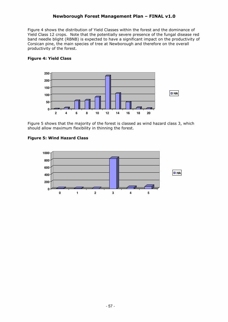
Newborough Forest Management Plan – FINAL v1.0
- 57 -
Figure 4 shows the distribution of Yield Classes within the forest and the dominance ofYield Class 12 crops. Note that the potentially severe presence of the fungal disease redband needle blight (RBNB) is expected to have a significant impact on the productivity ofCorsican pine, the main species of tree at Newborough and therefore on the overallproductivity of the forest.
Figure 4: Yield Class
0
50
100
150
200
250
2 4 6 8 10 12 14 16 18 20
HA
Figure 5 shows that the majority of the forest is classed as wind hazard class 3, whichshould allow maximum flexibility in thinning the forest.
Figure 5: Wind Hazard Class
0
200
400
600
800
1000
0 1 2 3 4 5
HA
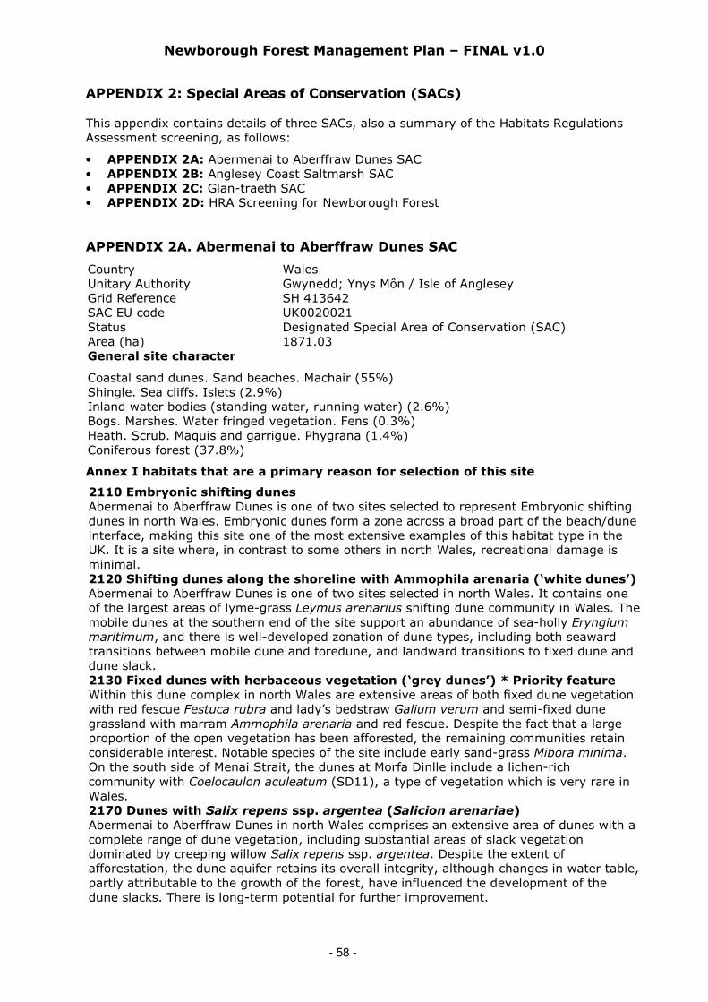
Newborough Forest Management Plan – FINAL v1.0
- 58 -
APPENDIX 2: Special Areas of Conservation (SACs)
This appendix contains details of three SACs, also a summary of the Habitats RegulationsAssessment screening, as follows:
• APPENDIX 2A: Abermenai to Aberffraw Dunes SAC• APPENDIX 2B: Anglesey Coast Saltmarsh SAC• APPENDIX 2C: Glan-traeth SAC• APPENDIX 2D: HRA Screening for Newborough Forest
APPENDIX 2A. Abermenai to Aberffraw Dunes SAC
Country WalesUnitary Authority Gwynedd; Ynys Môn / Isle of AngleseyGrid Reference SH 413642SAC EU code UK0020021Status Designated Special Area of Conservation (SAC)Area (ha) 1871.03General site character
Coastal sand dunes. Sand beaches. Machair (55%)Shingle. Sea cliffs. Islets (2.9%)Inland water bodies (standing water, running water) (2.6%)Bogs. Marshes. Water fringed vegetation. Fens (0.3%)Heath. Scrub. Maquis and garrigue. Phygrana (1.4%)Coniferous forest (37.8%)
Annex I habitats that are a primary reason for selection of this site
2110 Embryonic shifting dunes
Abermenai to Aberffraw Dunes is one of two sites selected to represent Embryonic shiftingdunes in north Wales. Embryonic dunes form a zone across a broad part of the beach/duneinterface, making this site one of the most extensive examples of this habitat type in theUK. It is a site where, in contrast to some others in north Wales, recreational damage isminimal.2120 Shifting dunes along the shoreline with Ammophila arenaria (‘white dunes’)
Abermenai to Aberffraw Dunes is one of two sites selected in north Wales. It contains oneof the largest areas of lyme-grass Leymus arenarius shifting dune community in Wales. Themobile dunes at the southern end of the site support an abundance of sea-holly Eryngiummaritimum, and there is well-developed zonation of dune types, including both seawardtransitions between mobile dune and foredune, and landward transitions to fixed dune anddune slack.2130 Fixed dunes with herbaceous vegetation (‘grey dunes’) * Priority feature
Within this dune complex in north Wales are extensive areas of both fixed dune vegetationwith red fescue Festuca rubra and lady’s bedstraw Galium verum and semi-fixed dunegrassland with marram Ammophila arenaria and red fescue. Despite the fact that a largeproportion of the open vegetation has been afforested, the remaining communities retainconsiderable interest. Notable species of the site include early sand-grass Mibora minima.On the south side of Menai Strait, the dunes at Morfa Dinlle include a lichen-richcommunity with Coelocaulon aculeatum (SD11), a type of vegetation which is very rare inWales.2170 Dunes with Salix repens ssp. argentea (Salicion arenariae)
Abermenai to Aberffraw Dunes in north Wales comprises an extensive area of dunes with acomplete range of dune vegetation, including substantial areas of slack vegetationdominated by creeping willow Salix repens ssp. argentea. Despite the extent ofafforestation, the dune aquifer retains its overall integrity, although changes in water table,partly attributable to the growth of the forest, have influenced the development of thedune slacks. There is long-term potential for further improvement.
Newborough Forest Management Plan – FINAL v1.0
- 59 -
2190 Humid dune slacks
Abermenai to Aberffraw Dunes represents Humid dune slacks in north Wales. There arelarge areas of open dune vegetation and many Humid dune slacks remain, although therehave been changes in the water table that are partly attributable to the growth of thecommercial forest. The changes have influenced the development of humid dune slacks,which nonetheless retain most the essential features of the habitat type.
Annex I habitats present as a qualifying feature, but not a primary reason forselection of this site
3150 Natural eutrophic lakes with Magnopotamion or Hydrocharition-type
vegetation
Annex II species that are a primary reason for selection of this site
1395 Petalwort (Petalophyllum ralfsii)
Abermenai to Aberffraw Dunes is an extensive complex of sand dunes, dune slacks, marsh,shingle and cliffs in south-west Anglesey, north Wales. There is a large population ofpetalwort Petalophyllum ralfsii here that was first recorded in 1828. This historicalcontinuity indicates that the site is especially favourable for the survival of this species.Although partly afforested, the open dunes have a very rich bryophyte flora, including themosses Amblyodon dealbatus, Catoscopium nigritum and the liverwort Southbya tophacea,particularly in damp, calcareous slacks and flats.1441 Shore dock (Rumex rupestris)
Abermenai to Aberffraw Dunes in north Wales is important as it represents shore dockRumex rupestris at the far north-west of its geographical range. It is remote from otherknown sites for this species, and shore dock occurs in an unusual situation: along a smallstream bed and on damp pond edges, formerly in duneland, now in a clearing in a coniferplantation. There are two small colonies, which held 21 flowering plants in 1994, 26 in1995 and 53 in 1996.
Annex II species present as a qualifying feature, but not a primary reason for
site selection: Not applicable (but note that great crested newt, otter and lesserhorseshoe bat are all present).
APPENDIX 2B. Anglesey Coast Saltmarsh SAC
Country WalesUnitary Authority Ynys Môn/ Isle of AngleseyGrid Reference SH380655SAC EU code UK0020025Status Designated Special Area of Conservation (SAC)Area (ha) 1058General site character
Tidal rivers. Estuaries. Mud flats. Sand flats. Lagoons (including saltwork basins) (80%)Salt marshes. Salt pastures. Salt steppes (15%)Shingle. Sea cliffs. Islets (5%)
Annex I habitats that are a primary reason for selection of this site
1310 Salicornia and other annuals colonising mud and sand
This is part of a complex of saltmarsh and dune habitats lying either side of the dunesystems at Newborough Warren, north Wales. It is therefore important in terms of thestructural integrity of the site, which has been selected primarily for a range of sand duneAnnex I types. The most significant stands of Salicornia spp. saltmarsh occur on MalltraethSands in the Cefni estuary.1330 Atlantic salt meadows (Glauco-Puccinellietalia maritimae)
This site, which includes both the Braint and Cefni estuaries, forms a complex of saltmarshand dune habitats lying either side of the dune systems at Newborough Warren. Atlantic
Newborough Forest Management Plan – FINAL v1.0
- 60 -
salt meadows form the bulk of the saltmarsh vegetation, but much of it is far fromtypical. In the Braint estuary the vegetation is characterised by unusually large amounts ofgreater sea-spurrey Spergularia media, whilst in the Cefni estuary the more typical Atlanticsalt meadow is subordinate to saltmarsh dominated by sea rush Juncus maritimus. In fact,this is one of the largest stands of Juncus maritimus saltmarsh in Britain, and has affinitieswith 1410 Mediterranean salt meadows (Juncetalia maritimi), an Annex I vegetationtype that is not now considered to occur in the UK.Annex I habitats present as a qualifying feature, but not a primary reason for selectionof this site1130 Estuaries
1140 Mudflats and sandflats not covered by seawater at low tide
Annex II species that are a primary reason for selection of this site: Notapplicable.
Annex II species present as a qualifying feature, but not a primary reason for
site selection: Not applicable.
APPENDIX 2C. Glan-traeth SAC (adjacent to Newborough Forest)
Country WalesUnitary Authority Ynys Môn/ Isle of AngleseyGrid Reference SH417666SAC EU code UK0030042Status Designated Special Area of Conservation (SAC)Area (ha) 14.1General site character
Coastal sand dunes. Sand beaches. Machair (90%)Inland water bodies (standing water, running water) (10%)
Annex I habitats that are a primary reason for selection of this site: Notapplicable
Annex I habitats present as a qualifying feature, but not a primary reason forselection of this site: Not applicable.
Annex II species that are a primary reason for selection of this site
1166 Great crested newt (Triturus cristatus)
Situated in north-west Wales, high counts since the mid-1980s confirm the presence of alarge and viable great crested newt (Triturus cristatus) population occupying water-filled depressions that have resulted from sand extraction from the dune system. Glan-traeth is lightly grazed by domestic livestock, thereby maintaining the open terrestrialhabitat required for feeding and sheltering of adults.
Annex II species present as a qualifying feature, but not a primary reason forsite selection: Not applicable

Newborough Forest Management Plan – FINAL v1.0
- 61 -
APPENDIX 2D. HRA Screening for Newborough Forest
1. Habitats Regulations Assessment for Likely Significant Effects of aForest Design Plan (FPD) Renewal on a European (or Ramsar) Site
Habitats Regulations Assessment of forestry operations / activities likely to have a significant effect on a European siteunder Regulation 48 of the Conservation (Natural Habitats, &c.) Regulations 1994 and in accordance with the HabitatsDirective (Council Directive 92/43/EEC).
1. Proposed operation / activity: Programmed felling/thinning/forest management operations and subsequentrestocking as per the agreed (2010) Newborough Forest Management Plan.
2. HRA reference no:
3. Site name / ref: Newborough Forest4. Location grid ref: SH4016525. Brief description of proposal: a. To fell/thin the crop trees and remove all merchantable conifer produce
from the programmed coupes.b. Re-plant some areas as per the agreed (2010) Newborough Forest
Management Plan.c. Carry out forest management operations e.g. forest road edge mowing
and the creation/management of recreation facilities as described in the(2010) Newborough Forest Management Plan.
6. European site name and status: a. Glannau Mon: Cors heli / Anglesey Coast: Saltmarsh SAC;b. Y Twyni o Abermenai i Aberffraw / Abermenai to Aberffraw Dunes SAC;c. Glan-traeth.
7. List of Interest Features whichmay be affected:
1. Embryonic dunes2. Shifting dunes along the shoreline3. Fixed dunes with herbaceous vegetation4. Dunes with Salix repens ssp argentea5. Humid dune slacks6. Shore dock (Rumex rupestris)7. Great crested newt
SCREENING
8. Is the whole of the proposal directly connected with or necessary to the management of the Site
for nature conservation? The answer here should only be ‘No’. An application for AA should not be made ifthe proposals are directly connected with the management of the European or Ramsar site.
No
9. What potential hazards are likely to affect the interest features?
Interest Feature Potential Hazard Mitigation
1. Embryonic dunes[Outside ofoperation area].
• Damage caused byharvesting vehiclesaccessing operation area.
• Brash and harvestingdebris dropped on to thefeature.
• Vehicles will not need access over this feature. However,ensure this is included in all documentation e.g. operationalcontract to specify the need to keep all vehicles off theseareas.
• During the felling operation any brash/lop & top thatincidentally falls onto this feature must be removed beforethe end of each day.
2. Shifting dunesalong the shoreline[within Zone 1 &4].
• Damage caused byharvesting vehiclesaccessing operation area.
• Brash and harvestingdebris dropped on to thefeature.
• Vehicle access will only be required where any tree cover ispresent. Access should be limited to the area behind thedunes (furthest from the sea).
• Some areas where any tree cover has been removed mayalso require stump removal. All associated debris will beremoved from this feature.
3. Fixed dunes withherbaceousvegetation [withinZones 3,4,5 &LISS]
• Localised accumulation ofbrash and harvestingdebris.
• Operational damage toexisting open ‘green’areas.
• Planting into existing openareas where desirablebotanical species presentlyoccur and which require anopen aspect.
• All lop & top will be distributed (rather than used as brashmats) throughout the operation areas in order to reducelocalised increase of dominant species i.e. bramble etc.
• No vehicles to travel across/through existing vegetatedareas. Also, trees must be felled away from these areas.
• Existing open habitat deemed to be valuable for existingdesirable botanical species will not be planted.
4. Dunes with Salixrepens sspargentea [withinZones 3,4,5 &LISS]
• Localised accumulation ofbrash and harvestingdebris.
• Operational damage toexisting open ‘green’areas.
• Planting into existing openareas where desirablebotanical species presentlyoccur and which require anopen aspect.
• All lop & top should be distributed (opposed to the use ofbrash mats) throughout the operation areas in order toreduce localised increase of dominant species i.e. brambleetc.
• No vehicles to travel across/through existing vegetatedareas. Also, trees must be felled away from these areas.
• Existing open habitat deemed to be valuable for existingdesirable botanical species will not be planted.
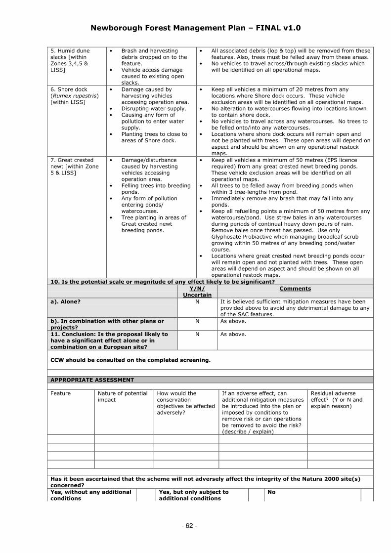
Newborough Forest Management Plan – FINAL v1.0
- 62 -
5. Humid duneslacks [withinZones 3,4,5 &LISS]
• Brash and harvestingdebris dropped on to thefeature.
• Vehicle access damagecaused to existing openslacks.
• All associated debris (lop & top) will be removed from thesefeatures. Also, trees must be felled away from these areas.
• No vehicles to travel across/through existing slacks whichwill be identified on all operational maps.
6. Shore dock(Rumex rupestris)[within LISS]
• Damage caused byharvesting vehiclesaccessing operation area.
• Disrupting water supply.• Causing any form of
pollution to enter watersupply.
• Planting trees to close toareas of Shore dock.
• Keep all vehicles a minimum of 20 metres from anylocations where Shore dock occurs. These vehicleexclusion areas will be identified on all operational maps.
• No alteration to watercourses flowing into locations knownto contain shore dock.
• No vehicles to travel across any watercourses. No trees tobe felled onto/into any watercourses.
• Locations where shore dock occurs will remain open andnot be planted with trees. These open areas will depend onaspect and should be shown on any operational restockmaps.
7. Great crestednewt [within Zone5 & LISS]
• Damage/disturbancecaused by harvestingvehicles accessingoperation area.
• Felling trees into breedingponds.
• Any form of pollutionentering ponds/watercourses.
• Tree planting in areas ofGreat crested newtbreeding ponds.
• Keep all vehicles a minimum of 50 metres (EPS licencerequired) from any great crested newt breeding ponds.These vehicle exclusion areas will be identified on alloperational maps.
• All trees to be felled away from breeding ponds whenwithin 3 tree-lengths from pond.
• Immediately remove any brash that may fall into anyponds.
• Keep all refuelling points a minimum of 50 metres from anywatercourse/pond. Use straw bales in any watercoursesduring periods of continual heavy down pours of rain.Remove bales once threat has passed. Use onlyGlyphosate Probiactive when managing broadleaf scrubgrowing within 50 metres of any breeding pond/watercourse.
• Locations where great crested newt breeding ponds occurwill remain open and not planted with trees. These openareas will depend on aspect and should be shown on alloperational restock maps.
10. Is the potential scale or magnitude of any effect likely to be significant?
Y/N/Uncertain
Comments
a). Alone? N It is believed sufficient mitigation measures have beenprovided above to avoid any detrimental damage to anyof the SAC features.
b). In combination with other plans orprojects?
N As above.
11. Conclusion: Is the proposal likely tohave a significant effect alone or incombination on a European site?
N As above.
CCW should be consulted on the completed screening.
APPROPRIATE ASSESSMENT
Feature Nature of potentialimpact
How would theconservationobjectives be affectedadversely?
If an adverse effect, canadditional mitigation measuresbe introduced into the plan orimposed by conditions toremove risk or can operationsbe removed to avoid the risk?(describe / explain)
Residual adverseeffect? (Y or N andexplain reason)
Has it been ascertained that the scheme will not adversely affect the integrity of the Natura 2000 site(s)concerned?
Yes, without any additionalconditions
Yes, but only subject toadditional conditions
No

Newborough Forest Management Plan – FINAL v1.0
- 63 -
If Yes, without additional conditions, scheme can be approved.
If Yes, but only subject to additional conditions, scheme can be approved subject to the following conditions:
Condition 1
Condition 2
12. Name and address of assessor:
Date:
13: CCW comments on assessment:
2. 14. Name of CCW officer: Date:
3. ATTACHMENTS:
Approval by Grants &Regulations, ForestryCommission Wales (theCompetent Authority)
NAME:POSITION:
Signed on behalf of Forestry Commission WalesConditions:
1.2.3.
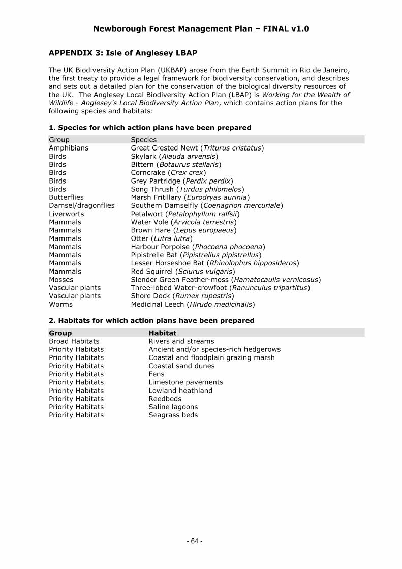
Newborough Forest Management Plan – FINAL v1.0
- 64 -
APPENDIX 3: Isle of Anglesey LBAP
The UK Biodiversity Action Plan (UKBAP) arose from the Earth Summit in Rio de Janeiro,the first treaty to provide a legal framework for biodiversity conservation, and describesand sets out a detailed plan for the conservation of the biological diversity resources ofthe UK. The Anglesey Local Biodiversity Action Plan (LBAP) is Working for the Wealth ofWildlife - Anglesey's Local Biodiversity Action Plan, which contains action plans for thefollowing species and habitats:
1. Species for which action plans have been prepared
Group SpeciesAmphibians Great Crested Newt (Triturus cristatus)Birds Skylark (Alauda arvensis)Birds Bittern (Botaurus stellaris)Birds Corncrake (Crex crex)Birds Grey Partridge (Perdix perdix)Birds Song Thrush (Turdus philomelos)Butterflies Marsh Fritillary (Eurodryas aurinia)Damsel/dragonflies Southern Damselfly (Coenagrion mercuriale)Liverworts Petalwort (Petalophyllum ralfsii)Mammals Water Vole (Arvicola terrestris)Mammals Brown Hare (Lepus europaeus)Mammals Otter (Lutra lutra)Mammals Harbour Porpoise (Phocoena phocoena)Mammals Pipistrelle Bat (Pipistrellus pipistrellus)Mammals Lesser Horseshoe Bat (Rhinolophus hipposideros)Mammals Red Squirrel (Sciurus vulgaris)Mosses Slender Green Feather-moss (Hamatocaulis vernicosus)Vascular plants Three-lobed Water-crowfoot (Ranunculus tripartitus)Vascular plants Shore Dock (Rumex rupestris)Worms Medicinal Leech (Hirudo medicinalis)
2. Habitats for which action plans have been prepared
Group Habitat
Broad Habitats Rivers and streamsPriority Habitats Ancient and/or species-rich hedgerowsPriority Habitats Coastal and floodplain grazing marshPriority Habitats Coastal sand dunesPriority Habitats FensPriority Habitats Limestone pavementsPriority Habitats Lowland heathlandPriority Habitats ReedbedsPriority Habitats Saline lagoonsPriority Habitats Seagrass beds

Newborough Forest Management Plan – FINAL v1.0
- 65 -
APPENDIX 4 – Trees Potentially Suitable for Planting at Newborough
General
Tree planting at Newborough will be done to encourage greater diversity asdiversification is considered the best way to plan for a future with an uncertain climate(by avoiding ‘all eggs in one basket’). The choice of tree and shrub species to be chosenfor planting will endeavour to create Atlantic dune woodland, which although endemicto parts of the Atlantic seaboard is not known to have occurred at Newborough in thedistant past.
There will be a considerable amount to learn about the best ways to create this type ofwoodland so the prescriptions outlined are of necessity only indicative at this stage. Asmore is learned through experience and practise, including overcoming technical issuessuch as obtaining appropriate stock and successfully establishing new species of trees,then these proposals can be sharpened up over time. This includes the preciseproportions of different species of tree (including the balance between broadleaves andconifers) and which trees to plant in which conditions (e.g. more shade-bearing speciesbeneath existing tree canopies and pines in more open areas).
Table 1: Likely species of tree & shrub to plant to create ADW
Species of Tree & Shrub
Willow, various species (Salix spp) [but not S. alba]Alder (Alnus glutinosa)Downy birch (Betula pubescens)Ash (Fraxinus excelsior)Sycamore (Acer pseudoplatanus) [will be accepted as naturalregeneration but will not be planted]
Oak, various species (Quercus spp)Elm (Ulmus glabra)Hazel (Corylus avellana)Elder (Sambucus nigra)Hawthorn (Crataegus monogyna)OTHER species of broadleaves, including rowan (Sorbus aucuparia),bullace (Prunus domestica var institia), wild cherry (Prunus avium),crab apple (Malus spp) [Consultees have expressed mixed views on useof beech (Fagus sylvatica); sweet chestnut (Castanea sativa) has also
been suggested as a possible species)]Pine, various species (Pinus spp)
Many of the species in Table 1 above will be expected to come in naturally to a degree,and natural regeneration will be encouraged as a silvicultural tool at Newborough asmuch as possible, in particular broadleaved regeneration. Other species, includingspecies of pine, some of which may have self-regeneration capability, will be controlledthrough ongoing management.
Although use will be made of natural regeneration where possible there will also be aconsiderable amount of planting at Newborough. The species – and provenances –chosen need to be presently well suited to the site and be likely to remain suited to thesite under most climate change predictions. All species of trees are expected to copebetter with the effects of climate change once they have become established (aftermoving from thicket stage to pole stage). This fact also supports not delaying thecreation of a more diverse forest, a process that should take place over a period of timebut not be delayed in starting.

Newborough Forest Management Plan – FINAL v1.0
- 66 -
Table 2 shows information published by Forest Research (FR) on likely suitable speciesfor site type and climatic zone at Newborough, which is ‘warm and dry below 50 metresasl’. It is also noted that soil fertility is a factor that can become limiting to a degree.
Table 2: Species recommended for sandy soils by Forest Research
Soil Type Broadleaves Conifers
Skeletal /Rankers
Downy birch (Betula pubescens)Sycamore (Acer pseudoplatanus)Alder (Alnus glutinosa)Rowan (Sorbus aucuparia)
Macedonian pine (Pinus peuce)lodgepole pine (Pinus contorta)Scots pine (Pinus sylvestris)Pines, various (Pinus spp)
Possible use of other pines at Newborough
The susceptibility of Corsican pine (Pinus nigra ssp laricio) [also known as Pinus nigrassp salzmannii var corsicana and Pinus nigra ssp maritima)] to red band needle blight(RBNB) has already been mentioned. The Pinus genus is known to fare well in hostilemaritime environments and given that there are many other pine species in existencealternative species need to be investigated. Table 3 below categorises a large number ofspecies of pine into different levels of susceptibility. Some species come into more thanone category.
Table 3: Table showing susceptibilities of different species of pine to RBNB
Susceptibility
Category*
Species of Pine
Highlysusceptible
P. attenuata, P. x attenuradiata, P. brutia, P. canariensis, P.cembroides, P. contorta var. latifolia, P. engelmannii, P. halepensis, P.jeffreyi, P. muricata, P. nigra ssp laricio, P. nigra ssp. nigra, P. pinea,P. ponderosa, P. radiata, P. sabineana, P. sylvestris, P. thunbergii
Moderatelysusceptible
P. bungeana, P. canariensis, P. caribaea, P. coulteri, P. cubensis, P.
densiflora, P. echinata, P. echinata x taeda, P. elliottii, P. flexilis, P.jeffreyi, P. kesiya, P. lambertiana, P. massoniana, P. monticola, P.
mugo ssp. mugo, P. muricata, P. occidentalis, P. palustris, P. pinaster,P. pungens, P. radiata var. binata, P. resinosa, P. roxburghii, P.strobiformis, P. strobus, P. taeda, P. thunbergii
Slightlysusceptible
P. aristata, P. ayacahuite, P. contorta, P. coulteri, P. devoniana, P.
elliottii, P. elliottii var. densa, P. hartwegii, P. heldreichii, P. koraiensis,P. merkusii, P. montezumae, P. monticola, P. nigra ssp. nigra, P.oocarpa, P. patula, P. pseudostrobus, P. rigida, P. sabineana, P.
serotina, P. sibirica, P. strobus, P. strobus L. var. chiapensis, P.sylvestris, P. tabuliformis, P. taeda, P. torreyana, P. wallichiana
Susceptibilityunknown
P. albicaulis, P. arizonica var. cooperi, P. banksiana, P. cembra, P.clausa, P. contorta x banksiana, P. contorta var. contorta, P. kesiyavar. kesiya, P. maximinoi, P. mugo ssp. rotundata, P. mugo subsp.uncinata, P. peuce, P. sylvestris var mongolica, P.tecunumanii
*Some of the pine species above come into more than one susceptibility category
Note that there is much still to be learned about the susceptibility of different pinespecies to RBNB, also in how susceptibility changes with different factors such as soiltype, micro-climate, stress factors, etc. The above table is therefore only indicative atthis stage.

Newborough Forest Management Plan – FINAL v1.0
- 67 -
Some of these pine species are known to regenerate freely but within the context of theforest this can be managed through cleaning and thinning in the early years of a crop’smanagement. Problems can also arise when freely regenerating species produce largequantities of seed or start to sucker. For these reasons any species of pine that haspotential invasive tendencies will be kept away from open dunes and dune slacks withinthe forest (see Figure 6.5 on page 46 above).
It should be noted however that pine regeneration may not always occur as expected.Corsican pine (Pinus nigra ssp laricio) for example hardly regenerates at all atNewborough although this species normally freely regenerates. Lodgepole pine (Pinuscontorta), on the other hand, does regenerate freely at Newborough but the are of thispine species is relatively small.
There is presently a moratorium on planting Corsican pine due to red band needle blight(RBNB) but two other pine species, maritime pine (Pinus pinaster) and Macedonian pine(Pinus peuce), appear to be more resistant to this disease and may have some potentialfor planting at Newborough.
Earlier literature suggests that the performance of maritime pine at Newborough wasconsidered inferior to Corsican pine but this appears to have been based on limitedtrialling and, being a coastal pine that is widely planted on the sands of south-westFrance, will be given further consideration. Provenance testing is being included inForest Research’s new series of species trials, and it is presently intended to includefurther plots of this species at Newborough.
Macedonian pine has also only had limited trialling at Newborough and there is anexisting plot of this species that shows potential for this species. Two other pines –Monterey pine (P. radiata) and bishop pine (P. muricata) – have been trialled here butboth are too susceptible to RBNB now to be planted. There is little specific informationon the performance of Scots pine (Pinus sylvestris) at Newborough, presumably becausethe decision was made to go with Corsican pine from the start.
A number of species plots were established many years ago in Newborough Forest andwere visited once again by Forest Research in 2007 to assess their value for RBNBstudies. It was noted at the time that RBNB was well established in the forest and thatthe crowns of Corsican pine were generally looking thin.
Table 4: Pine provenance trials at Newborough
Compartment Notes on the various pine species (2007)
Newboroughpinetum, Cpt 13
This pinetum originally had 25 plots of various pine species planted1949-60 of which only remnants now remain. There are some largespecimens of Monterey pine (P. radiata) (P51) and relatively intactplots of Virginia pine (P. virginiana) (P52) and Japanese red pine (P.densiflora) (P60), both of which are relatively small. There is a largeplot of reasonably uniform Macedonian pine (P. peuce) (P58) and afew scattered remnants of Jeffrey pine (P. jeffreyi) (P57). Thepinetum will be retained and may even be considered as part of aminor arboretum.
NewboroughCpt 12, P75
This compartment contains plots of Corsican pine (Pinus nigra ssplaricio), Monterey pine (P. radiata), and bishop pine (P. muricata).One plot of Monterey pine was high pruned in the 1990s for thePotential Plantation Species programme. The trees are all inreasonable condition but are probably too old for use in RBNBstudies. This experiment will be retained for long-term retention.
Species plots This compartment contains a series of species plots close to the large

Newborough Forest Management Plan – FINAL v1.0
- 68 -
Cpt 30 plot of Macedonian pine (P. peuce) (see below). The plots containAbies, Picea and Thuja species but no pines. The origin of these plotsis uncertain as no experiments with these species are recorded on thedatabase under Newborough (but they could be a under a differentforest name, which requires further investigation). These plots are oflimited value for RBNB studies.
Pinus peuceCpt 30
This large plot of Macedonian pine (P. peuce) is marked only as XP onthe stock map and is probably P59. The trees are variably spaced,have slow growth, and most have good form, are apparently healthy,and regenerating. A useful plot of this potential plantation species.
There are also plots of other conifers already established at Newborough which areworthy of further scrutiny in deciding which coniferous species are likely to be bestsuited to plant from here on.
Table 5: Susceptibility of other conifer species to RBNB
Susceptibility
Category
Other Species of Conifer (other than Pine)
Not known(but thought tobe of lowsusceptibility)
Norway spruce (Picea abies)Serbian spruce (Picea omorika)Colorado blue spruce (Picea pungens)Sitka spruce (Picea sitchensis)Schrenk’s spruce (Picea schrenkiana)Douglas fir (Pseudotsuga menziesi)European larch (Larix decidua)[Note that Japanese larch (Larix kaempferi) is now known to
be susceptible to Phytophthora ramorum, which is why there is
presently a moratorium on planting this species, but the
situation with European larch is less clear]
At present the susceptibility of other conifer species to RBNB is largely unknown.
Forest Research is continuing its research into the suitability of new species andprovenances of pine as part of the climate change adaption programme. It is alsoacknowledged that other species and provenances – in particular oak species – needmore work.
The list of species likely to be deemed suitable for creating Atlantic dune woodland(Table 1 supplemented by the species in Tables 2, 3 & 5 above) at Newborough is likelyto become refined over time as our experience of planting new species develops. It isimportant to give an indication of any new species that will be required as soon as theseare known as many species will take time to source or to grow from seed in the nursery.Macedonian pine for example will take 4 years to grown from seed.
Atlantic dune woodland
Tree planting at Newborough will be carried out predominantly to favour the creation ofAtlantic dune woodland (ADW), which in the Atlantic region is defined as ‘wooded dunes’or ‘coastal dunes with near-natural woodland’.
ADW consists of natural or semi-natural forests within the Atlantic region coastal duneswith a well-developed woodland structure and an assemblage of characteristic woodlandspecies. It corresponds to oak groves and beech-oak groves with birch on acid soils.
Newborough Forest Management Plan – FINAL v1.0
- 69 -
Pioneer stages are open forests with Betula spp. and Crataegus monogyna, mixedforests with Fraxinus excelsior, Quercus robur, Ulmus glabra and Acer pseudoplatanusor, in wet dune slacks, pioneer forests with Salix alba which develop into humid mixedforests or marsh forests.
In the UK, the Joint Nature Conservation Committee (JNCC) considers there to be nosubstantive examples of this habitat at the present time in the UK. The UK Sand DuneBAP recognises that it may formerly have been present and proposes the selection of 5sites for the experimental creation of Atlantic dune woodland.
Atlantic dune woodland at Newborough:
With regard to Newborough Forest the key element of the definition is ‘natural or semi-natural forests (long established)...with a well developed woodland structure and anassemblage of characteristic woodland species’. Newborough Forest is presently none ofthese things; it is not natural or semi-natural having been planted mainly less than 50years ago and comprising mainly non-native tree species. It has a poor woodlandstructure lacking a diversity of age classes, understorey or ground layer. Many of theplant species within the forest are relicts from the earlier dune flora and only thelandward portions are beginning to acquire common woodland plants by (mostly) naturalcolonisation. Some areas are also acquiring an interesting fungus flora but nowhere arethere indicators of ancient woodland.
Atlantic dune woodland can potentially develop at Newborough in time, with birch, oakand sycamore being the main species. The dune slacks will probably become willowdominated with alder perhaps less abundant due to its limited dispersal in this terrain.Ash might occur where water levels are stable and an understorey of shrubby speciesincluding hazel, elder and hawthorn can be expected. The varied topography of theterrain is likely to lead to quite sudden spatial variation (e.g. from oak/birch to willowdominance at the edges of slacks) and a diverse mosaic of vegetation types. Corsicanpine – RBNB permitting – is likely to remain as the overlying structure of the forest for aperiod to come but the dominance of this species is expected to reduce fairly rapidly asnew species are introduced.

Newborough Forest Management Plan – FINAL v1.0
- 70 -
APPENDIX 5 – Abbreviations
• AA: Appropriate Assessment, required as part of Habitats Regulations Assessment• ADW: Atlantic Dune Woodland, a type of woodland native to the Atlantic region• AP: Action point. These are covered in Section 6, proposed actions• ASL: Above Sea Level, the altitude above mean sea level usually measured in metres• AONB: Area of Outstanding Natural Beauty• ARSP: Anglesey Red Squirrel Project• AWE: Assembly Woodland Estate, the area of woodland owned by the National
Assembly for Wales and managed by Forestry Commission Wales• BAP: Biodiversity Action Plan, see Appendix 3• CCW: Countryside Council for Wales• CEH: Centre for Ecology & Hydrology• DDA: Disability Discrimination Act• EPS: European Protected Species, defined species given protection under the
Habitats Directive• FCW: Forestry Commission Wales• FD: Forest District, the management unit of FCW, here Coed y Mynydd FD• FDM: Forest District Manager, the manager for Coed y Mynydd FD and an FCW
employee• FDP: Forest Design Plan• FSC: Forestry Stewardship Council, a certification body• FR: Forest Research, an agency of the Forestry Commission• GCN: Great Crested Newt, a species of amphibian which is also an EPS (see above)• GCR: Geological Conservation Review• HRA: Habitats Regulations Assessment, see also AA above• IoACC: Isle of Anglesey County Council• IPCC: Intergovernmental Panel on Climate Change• JNCC: Joint Nature Conservation Committee• LA: Local Area, a management unit of Coed y Mynydd FD, here Eryri LA• LAM: Local Area Manager, the manager for the Eryri LA and an FCW employee• LISS: Low Impact Silvicultural System, a method of continuous cover forestry• LRC: Local Record Centre• m3obs: Cubic metres overbark standing, a measure of standing volume of timber• MTI: Management Table Intensity, the amount of timber that should be removed in
thinnings – given declared parameters such as species and growth rate – accordingto FC Booklet 48
• N2K: Natura 2000• NAW: National Assembly for Wales• NFP: Newborough Forest Partnership, officially formed in 2005• NLP: Newborough Liaison Partnership• NNR: National Nature Reserve• OGB: Operational Guidance Booklets, internal guidance information for FC staff;
OGB1 covers tree safety• OLDSI: Operations Likely to Damage the Special Interest. This was formerly known
as PDO (Potentially Damaging Operations)• PEFC: Programme for the Endorsement of Forestry Certification, a certification body• PDO: Potentially Damaging Operations• RBNB: Red Band Needle Blight, a disease caused by the fungus Dothistroma
septosporum which attacks pine, in particular Corsican pine although other pines aresimilarly susceptible.
• RIGS: Regionally Important Geological Site• SAC: Special Area of Conservation [cSAC: Candidate SAC]• SAM: Scheduled Ancient Monument• SSSI: Site of Special Scientific Interest

Newborough Forest Management Plan – FINAL v1.0
- 71 -
• UKWAS: UK Woodland Assurance Scheme, the certification standard used by FCW.The second edition of the standard was introduced in 2006 and a third edition isexpected in 2011
• YC: Yield Class, a measure of the growth rate of crops (YC14 for example refers to agross growth rate of 14m3 overbark standing per hectare per year. The amount oftimber to be removed in one hectare of a marginal intensity thinning in this examplewould be 14m3 x 1ha x 5 years (or other thinning cycle) ÷ 1.21 (conversion fromm3obs to tonnes))

Newborough Forest Management Plan – FINAL v1.0
- 72 -
APPENDIX 6 – Map of Newborough Forest