Embed Size (px)
Citation preview

OneGeology- Behind the Hypeand why it’s good for GA
OneGeology- Behind the Hypeand why it’s good for GA
Ollie Raymond
with Lesley Wyborn, Simon Cox, Paul Buckley, Robyn Gallagher, Dale Percival, Wade Randall, Aaron Sedgmen, David Wu
Ollie Raymond
with Lesley Wyborn, Simon Cox, Paul Buckley, Robyn Gallagher, Dale Percival, Wade Randall, Aaron Sedgmen, David Wu

193 years from this… …to this
OneGeology Launch – 33rd IGC, Oslo
20081815
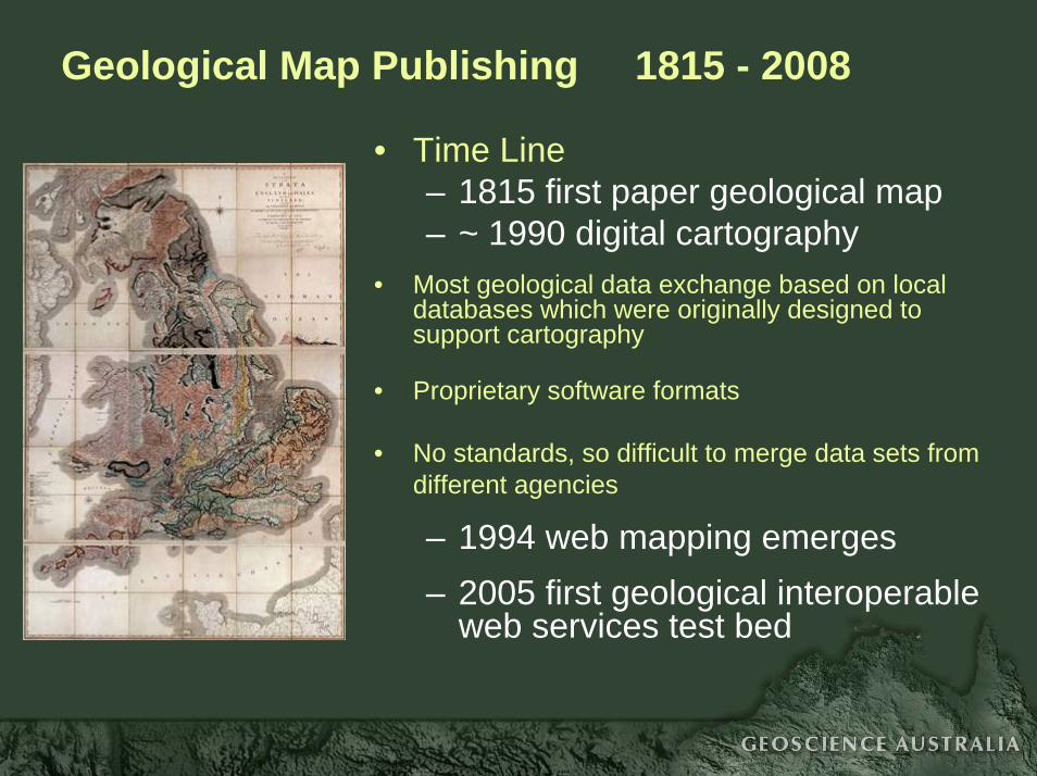
Geological Map Publishing 1815 - 2008
• Time Line– 1815 first paper geological map– ~ 1990 digital cartography
• Most geological data exchange based on local databases which were originally designed to support cartography
• Proprietary software formats
• No standards, so difficult to merge data sets from different agencies
– 1994 web mapping emerges– 2005 first geological interoperable
web services test bed

Web services?
Que?
A software system that supports interoperable, machine-to-machine interaction (eg, exchanging data between computers) over a network
• data broadcast to the internet using standard internet protocols, and open source, non-proprietary data standards
• accessed by a service URL and standard requests• eg, http://www.ga.gov.au/wms/getmap?dataset=national&request=getCapabilities

OGC Web ServicesWeb Map Service vs Web Feature Service
WMS• an image (typically gif or png) of the map data• display coloured or symbolised legends• display or overlay map layers in a web browser• designed for generating and viewing maps online• point-and-click query function for simple attribute data• not designed to download the data for complex analysis• standard format for serving and requesting images of
maps, but no standard attribute structure within the data• fast delivery, simple data

OGC Web ServicesWeb Map Service vs Web Feature Service
WFS• all of the data behind the map
- may include complex, hierarchical attribute data- may include coordinates of point/line/polygon shapes- ASCII (text) format delivery for vector data
• can perform complex queries on complex data• not designed for rendering complex map shapes;
slow delivery to a map window compared to WMS images• can download the data to your desktop application• attribute structure and content governed by standard data
transfer models (eg, GeoSciML)

The OneGeology Portal

OneGeology is more than a digital map…..
• Free access to globally distributed geological data through a single internet portal
• Geological data are in a single standardised format from any OneGeology participant
• Data conforms to generic ISO and OGC standards - WMS (Web Map Service)- WFS (Web Feature Service)- GML (Geography Markup Language)
• Uses GeoSciML for WFS - a standard data transfer model and encoding for geological attribute data

The delivery model
Web
ClientWMS WFS
WMSWFS
WMSWFS
WMS WFS
WMS WFS
GA
BRGM
BGS
USGS
GSCGSC mapping
GeoSciML
GeoSciML
GeoSciML
GeoSciML
GeoSciML
GeoSciML format
USGS mapping
BGS mapping
GA mapping
BRGM mapping
Database to GeoSciML schema mapping
Canada
USA
UK
OneGeologyportalFrance
Australia
Data sources OGC Services

3D model service
and a few tools
2D map service
Fluid modelling service
80+ countries only need… 1 Portal…

OneGeology – levels of participation
• OneGeology - Level 1 - WMS; easy to set up using the cookbook provided- basic map attributes (eg, using a shapefile)- no standard attribute structure, except for a general request for attributes describing lithology and age
• OneGeology - Level 2- WFS; data transfer using GeoSciML- compliance to standard data structures and vocabularies- more complex IM and software infrastructure required
Demands of WFS delivery can expose limitations in existing information systems
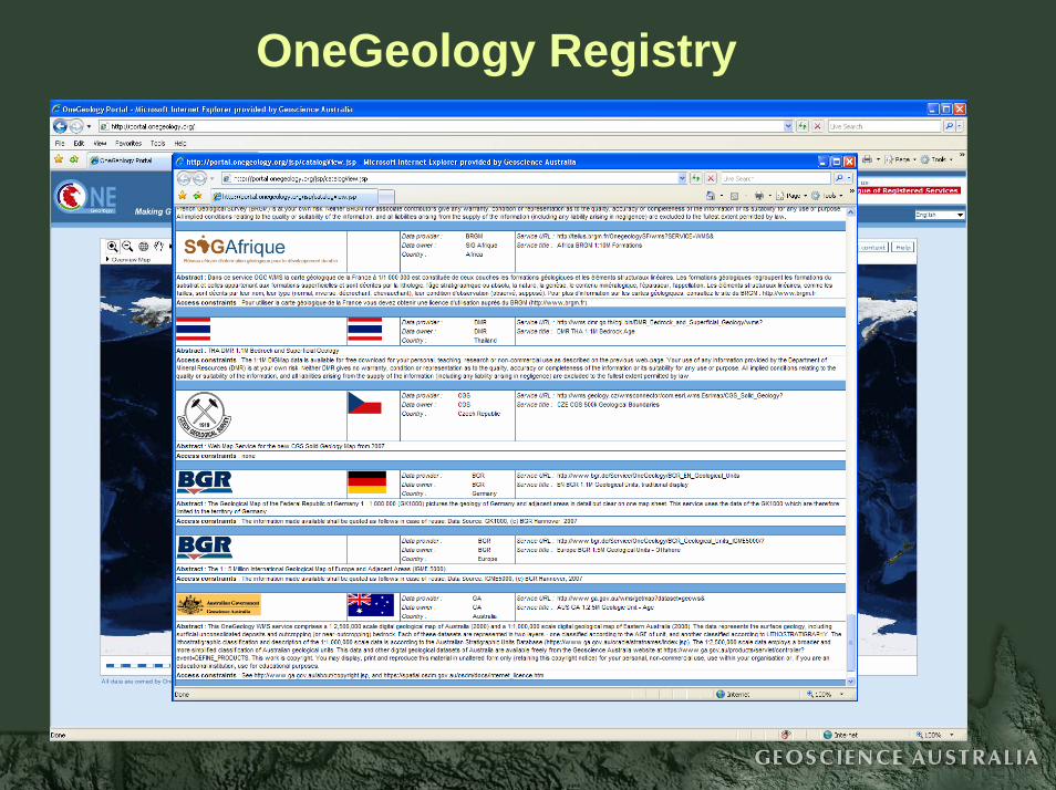
OneGeology Registry

OneGeology – Level 1

OneGeology – Level 1

OneGeology – Level 1

OneGeology – Level 1

OneGeology – Level 2
GML
GeoSciML

Interaction and Integration of Earth Science data
• Similar international initiatives to OneGeology in other domains
– topography, water, marine and climate domains– same technology framework as OneGeology
- GML, WMS, WFS, Catalog Services, etc– OneGeology will integrate with these domains

OneGeology – where to from here?
• More sophisticated uses of Web Map Services and GeoSciML Web Feature Services
• Examples from the GeoSciML Testbed #3
- also demonstrated at 33rd IGC, Oslo

GeoSciML Testbed 3

Resymbolise a web map – Style Layer Descriptor (SLD)

Resymbolise a web map – Style Layer Descriptor (SLD)

Registry of standard vocabularies

Registry of standard vocabularies

Registry of standard vocabularies

Registry of WMS and WFS services

Download a WFS dataset

Query a geological WFS using a standard vocabulary- hierarchical, multilingual
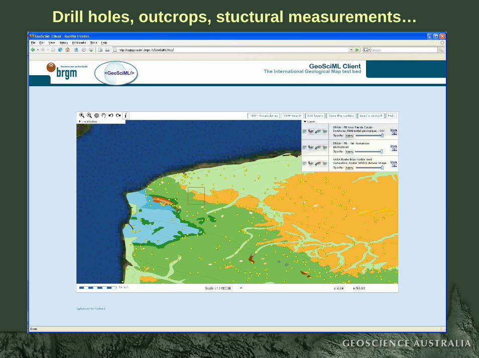
Drill holes, outcrops, stuctural measurements…

Drill holes, outcrops, stuctural measurements…

Drill holes, outcrops, stuctural measurements…

Drill holes, outcrops, stuctural measurements…

GeoSciML data in commercial applications
• ArcGIS- ESRI- and GA-developed import tool
• Oracle• GeoModeller• GSI3D• BRGM Borehole viewer

GeoSciML WFS data in ArcGIS

So why is OneGeology good forGA and Australia?
Because OneGeology is the same model for geoscience data delivery that we are aiming for in Australia.
We now have an operating infrastructure model that we can copy for our own.
The pretty coloured map of Cameroon?

WesternAustralia
Description
Label
Age
Why does Australia need a WFS data delivery model?
Why does Australia need a WFS data delivery model?
NorthernTerritory
ESRI MAPINFOESRI MAPINFO

Government Geoscience OnlineGovernment Geoscience Online
• 8 online geoscience delivery systems
• 8 data structures
• 2 proprietary (software-specific) data formats
• cannot view, query or download more than oneagency’s data at a time
• 8 online geoscience delivery systems
• 8 data structures
• 2 proprietary (software-specific) data formats
• cannot view, query or download more than oneagency’s data at a time

Where to next in Australia ?
Australian Geoscience Portal
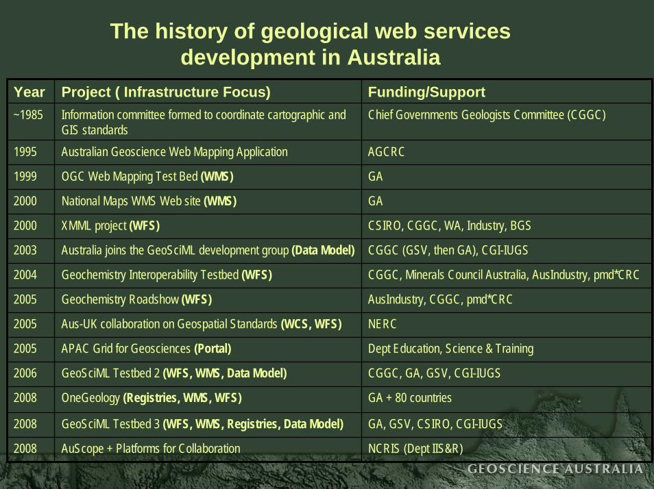
The history of geological web services development in Australia
Year Project ( Infrastructure Focus) Funding/Support~1985 Information committee formed to coordinate cartographic and
GIS standardsChief Governments Geologists Committee (CGGC)
2005 Geochemistry Roadshow (WFS) AusIndustry, CGGC, pmd*CRC
2008 GeoSciML Testbed 3 (WFS, WMS, Registries, Data Model) GA, GSV, CSIRO, CGI-IUGS
2008 AuScope + Platforms for Collaboration NCRIS (Dept IIS&R)
1995 Australian Geoscience Web Mapping Application AGCRC
1999 OGC Web Mapping Test Bed (WMS) GA
2000 National Maps WMS Web site (WMS) GA
2000 XMML project (WFS) CSIRO, CGGC, WA, Industry, BGS
2005 Aus-UK collaboration on Geospatial Standards (WCS, WFS) NERC
2005 APAC Grid for Geosciences (Portal) Dept Education, Science & Training
2003 Australia joins the GeoSciML development group (Data Model) CGGC (GSV, then GA), CGI-IUGS
2004 Geochemistry Interoperability Testbed (WFS) CGGC, Minerals Council Australia, AusIndustry, pmd*CRC
2006 GeoSciML Testbed 2 (WFS, WMS, Data Model) CGGC, GA, GSV, CGI-IUGS
2008 OneGeology (Registries, WMS, WFS) GA + 80 countries


Geological data types for an Australian Geoscience Portal
• Geological maps - GeoSciML
• Field sites - GeoSciML, O&M
• Drill holes - GeoSciML, O&M
• Mineral deposits - data model currently being tested
• Geochemistry - data model currently under development
• Geochronology - data model currently under development
• Geophysics - web coverage services (WCS) and other technologies
• Tenements - model to be developed
In conclusion…
Web services for geological data have arrived- no longer a pipe dream
• OneGeology and the GeoSciML Testbed are showcasing how WMS and WFS can be used to deliver distributed geological data in standard formats using standard protocols
• Now is the time for the Australian geological surveys to build our own ‘OneGeology’ and showcase our vast array of government geological data to the world