Embed Size (px)
Citation preview
IMPRESSUM
Nakladnik | Editore | Publisher | HerausgeberTuristička zajednica Grada Buzeta | Ente turistico dellà citta di Buzet | Buzet Tourist Office | Tourismusverband BuzetŠetalište Vladimira Gortana 9, HR-52420 Buzet, CroatiaT. +385 52 662 343, F. +385 52 662 [email protected], www.tz-buzet.hr
Turistička zajednica Općine Motovun | Ente comunale per il turismo di Montona | Tourist Association - Motovun | Motovun TouristichegemeinschaftTrg Andrea Antico 1, HR-52424 Motovun, CroatiaT. +385 52 681 [email protected], www.tz-motovun.hr
Turistička zajednica Središnje Istre | Ente per il turismo Istria centrale |
Central Istria Tourist Board | Tourismusverband Zentral IstrienVeli Jože 1, HR-52000 Pazin, CroatiaT. +385 52 622 460, F. +385 52 616 [email protected], www.central-istria.com
IRTA d.o.o.Bike & Outdoor DMCPionirska 1a, HR-52440 Poreč, Croatia
Za nakladnika | Per l’editoreFor the publisher | Für den HerausgeberSiniša Žulić, Iva Jeletić Prodan, Sanja Kantaruti
Partneri | Partners | Partner | PartnerOdjel za turizam Istarske županije | Assessorato al turismo della Regione Istria | Department for Tourism of the Istrian Region | Verwaltungsbüro für Fremdenverkehr der Region IstrienPartizanska 5a, HR-52440 Poreč, Croatia
Turistička zajednica Istarske županije | Ente per il turismo dell’Istria |Istria Tourist Board | Tourismusverband IstrienPionirska 1, HR-52440 Poreč, CroatiaT. +385 52 452 797
Suradnici na projektu | Collaboratori al progettoProject collaborators | Projekt MiratbeiterSerđo Peruško, Massimo Ferrara, Alen Paliska
Urednik | Redattore | Editor | RedakteurMartin Čotar
Koncept | Idea grafica | Concept | Konzept Studio Sonda, Vižinada
Grafičko oblikovanje | Allestimento grafico | Graphic design | Gestaltung Lastik studio, Žminj
Fotografije | Fotografie | Photo credits | FotosIRTA d.o.o. - Bike&Outdoor DMC, TZG Buzet, TZO Motovun, LuxAir Media
Tisak | Stampa | Print | Druck06/2017
Atrakcije / Luoghi da visitare / Highlights / Höhepunkte:
Atrakcije / Luoghi da visitare / Highlights / Höhepunkte:
Atrakcije / Luoghi da visitare / Highlights / Höhepunkte:
Atrakcije / Luoghi da visitare / Highlights / Höhepunkte:
Atrakcije / Luoghi da visitare / Highlights / Höhepunkte:
Atrakcije / Luoghi da visitare / Highlights / Höhepunkte:
1 SOVINJAK − Podno stoljetna kestena vrijeme odbrojava kameni sunčani sat. Dvorište velike župne crkve krije pogled prema uskoj dolini Mirne, uspavanim mlunskim poljima i vinogradima te prema osamljenoj Ćićariji na sjeveru. To je Sovinjak. Predaja kaže da je rimska carica Livia Drusilla naručivala i pila isključivo vino Pucinum iz Sovinjaka, otuda i njegova slava. Osim po proizvodnji vina, Sovinjak je znan i po proizvodnji vrhunskog „tekućeg zlata“ - maslinovog ulja. Početkom listopada svake godine, u tom malom gradiću održava se Bela nedeja, pučka fešta kada se mogu degustirati vina i pjenušci.
SOVINJAK − La tradizione dice che l’imperatrice romana Livia Drusilla beveva solamente il vino Pucinum di Sovignacco e da qui la sua notorietà. Accanto alla produzione di vino Sovinjak (Sovignacco) è conosciuta anche per la produzione dell’„oro liquido“- l’olio d’oliva. A Sovinjak c’è la chiesetta del Quattrocento i cui affreschi sono stati dipinti da Domenico da Udine, 1571. Ogni anno all’inizio di ottobre a Sovignacco si tiene la sagra „Bela nedeja“ (La domenica bianca) con degustazione di vini locali.
SOVINJAK − In Sovinjak, under the hundred-year old chestnut tree, the stone sun-clock counts time. The courtyard of the large parochial church reveals the view of the narrow Mirna Valley, the sleepy Mlunska Polja and the vineyards towards the north of the lonely Ćićarija. Legend has it that the Roman empress Livia Drusilla ordered and drank exclusively the wine Pucinum from Sovinjak, which made it so famous. In addition to wine production, Sovinjak is also well-known for the production of top quality “liquid gold” - olive oil. At the beginning of October every year this small town hosts White Sunday, the folk festival of wine and sparkling wine.
SOVINJAK − Der Legende nach, hätte die römische Kaiserin Livia Drusilla aus-schließlich den Wein Pucinum aus Sovinjak bestellt, daher sein Ruhm. Neben der Weinproduktion ist Sovinjak auch für die Produktion der goldenen Spitzenflüssigkeit bekannt, des Olivenöls. In Sovinjak befindet sich das Kirchlein des Hl. Rochus, des-sen Interieur Domenico aus Udine im Jahr 1571 bemalt hat. Anfang Herbst jedes Jahres findet in diesem Ort die sogenannte „Bela nedeja“ statt. Es handelt sich um ein Volksfest, auf dem man verschiedene Weine und Sekte probieren kann.
2 VRH − Maleni istarski gradić smjestio se na vrhu brda sjeverno od jezera Butoniga. Ovaj izuzetan položaj omogućuje Vam da sa vrha zvonika vidite više od 130 gradova, gradića, sela i crkava na istarskom poluotoku. Vrhuvština broji 17 sela u kojima živi 700 - tinjak stanovnika. Sam gradić ima 40 kuća smještenih oko župne crkve Marijina Uznesenja. U Vrhu, u župnoj crkvi Uznesenja Marijina iz 1231. g. nalazi se najznačajniji spomenik tzv. kamena kustodija s likovima prikazanim u dekorativnom ukrasu i glagoljskim natpisom. Drugi stari arhitektonski spomenik Vrha je kapela Sv. Antuna opata, podignuta u XV. st., a obnovljena 1894. godine uz prilaznu cestu južno od naselja. Danas je na kapelici vidljiva kamena ploča s glagoljskim natpisom koji donosi godinu gradnje, ime graditelja te župnika i laičkih upravitelja crkvene imovine.
VRH − Il piccolo borgo istriano situato in cima al colle nei pressi del lago di accu-mulo Butoniga, in direzione nord. Il paese è cosi’ meravigliosamente posizionato che da qui si possono scorgere ben 130 cittadine, paeselli e campanili della pe-nisola istriana. L’intera zona della Vrhovština conta 17 paesi e circa 700 abitanti. Il paese di Vrh ha una quarantina di case tutte situate nei pressi della chiesa parrochiale inaugurata all’Assunzione della Vergine Maria. Nella chiesa che data il 1231 vi si trova un monumento, una custodia in pietra con volti rappresentati da delle decorazioni e attorniati da scritte glagolitiche.
VRH − This small Istrian town is perched on a hill north of Butoniga Lake. This exceptional position enables you to see over 130 towns, villages and churches of the Istrian peninsula from its bell tower. The area of Vrh known as Vrhuvština comprises 17 villages with about 700 inhabitants. The town has 40 houses situ-ated around the parish church of the Assumption of the Virgin Mary. The parish church of the Assumption of the Virgin Mary from 1231 houses the most important monument known as the stone repository with decorative figures and a Glago-litic inscription. Another old architectural monument in Vrh is the chapel of St. Anthony the Abbot, built in the 15th century and reconstructed in 1894 which lies along the road, south of the town. On the chapel is a stone plaque with Glagolitic inscription indicating the year of construction, name of builder, priest and laymen who managed the church property.
VRH − Ein winziger istrischer Ort am Hügelgipfel, nördlich von dem Butonigasee. Die außerordentliche Lage ermöglicht, dass man vom Turmgipfel über 130 Städte, Städtchen, Dörfer und Kirchen der Halbinsel sieht. Die Gegend von Vrh zählt 17 Dörfer, in welchen ungefähr 700 Einwohner leben. Allein die Stadt hat ungefähr 40 Häuser, alle in der Nähe der Pfarrkirche Mariä Himmelfahrt. In der Pfarrkirche von Vrh aus dem Jahre 1231 befindet sich ein pretiöses Denkmal, eine Steinwache, auf der Figuren und eine glagolitische Inschrift im Reliefkunst dargestellt sind. Das zweite architektonische Bauwerk ist die Kapelle des Hl. Antons Abtes. Das Gebäude befindet sich an der Zufahrtsstraße, und wurde im XV. Jhr. gebaut, und im Jahr 1894 renoviert. Heute ist auf der Außenseite der Kapelle eine glagolitische Inschrift sichtbar, die das Baujahr, den Namen des Baumeisters, des Pfarrers und des laischen Verwalters des Kircheneigentums aufweist.
Atrakcije / Luoghi da visitare / Highlights / Höhepunkte:
1 KALDIR, VINO I VOĆE − Blaga, gotovo primorska klima, koja na ovaj kraj utječe dolinom rijeka Mirne pogoduje poljoprivredi, poglavito voćarstvu, koje njeguje veći broj domaćinstava u okolici Kladira. Zahvaljujući njima Kaldir je postao najpoznatiji voćarski kraj u Istri, a Kaldirština daje gotovo 70 posto voćarske proizvodnje u Istri. Na ovom prostoru zajedno uspijevaju kontinentalne sorte: jabuke, šljive, kruške, breskve i marelice, te medi-teranske sorte: masline, smokve i trešnje, a u okolici se pronalaze i tartufi. Kaldir je poznat i po vrhunskim vinima. Povoljan geografski položaj, pedološke karakteristike i mikroklima pogoduju uzgoju raznim sortama vinove loze od čijih plodova marni vinari proizvode odlična vina. Osim voćara i vinara u ovoj „Maloj istarskoj Kaliforniji“ kako u šali znaju reći Kaldirci djeluju i pčelari koju u ovakvom okruženju mogu proizvesti samo vrhunski med.
1 POKLON − Prijevoj na Učki na povijesnom hodočasničkom putu iz Istre na Trsat, na mjestu gdje se hodočasnicima prvi puta otvara pogled na zavjetnu crkvu Gospe Trsatske, gdje se prekriže i poklone, od čega potječe i ime ovog 922 metra visokog prijevoja. Ujedno je to i lokacija istoimenog planinarskog doma te info centra Parka prirode Učka, otvorenog u toplijem dijelu godine.
POKLON − Sella sul Monte Maggiore (Učka) sullo storico percorso di pellegrinaggio dall’Istria a Tersatto ed il punto da dove si apriva la prima vista sulla chiesa votiva della Madonna di Tersatto alla quale i pellegrini s’inchinarono e fecero il segno della croce. È da qui che deriva il nome di questo passo alto 922 metri, poklon significa inchino. Oggi Poklon è anche la posizione del rifugio omonimo e del Centro informazioni del Parco Naturale Učka, aperto durante i mesi più caldi dell’anno.
POKLON − The 922 meter high pass between the mountains of Učka and Ćićarija on the historic pilgrimage route from Istria to Trsat. The point from where the first view of the votive church of Our Lady of Trsat opened to the pilgrims who then bowed to the church and made the sign of the cross. It is from this tradition that the pass’s name derives, poklon means bow. Today Poklon is also the position of the homonymous refuge and of the Information Center of the Nature Park Učka, open during the warmer months of the year.
POKLON − Der 922 Meter hohe Pass zwischen den Bergen von Učka und Ćićarija auf dem historischen Pilgerweg von Istrien nach Trsat. Der Punkt, von wo aus der erste Blick auf die Votivkirche Unserer Lieben Frau von Trsat den Pilgern zugeöffnet wurde, die sich dann zur Kirche verbeugten und das Zeichen des Kreuzes machten. Es ist von dieser Tradition, dass der Name des Passes ableitet, poklon bedeutet Bogen. Heute ist Poklon auch die Position der gleichnamigen Zuflucht und des Informationszentrums des Naturparks Učka, die in den wärmeren Monaten des Jahres geöffnet ist.
2 LUPOGLAV − Smješten podno Ćićarije, na 384 metara visine, po prvi puta spominje se u darovnici njemačko-rimskoga cara Henrika IV. iz 1064. kao Lompaga. Od najranijih vremena koristi se i hrvatski oblik imena, dok je njemačka inačica Mährenfels nastala kasnije. Danas je sjedište općine i važno prometno čvorište te ishodište planinarskih pohoda na obližnju Učku i Ćićariju (Park prirode Učka).
LUPOGLAV - LUPOGLIANO − Situato ai piedi della Cicceria, all’altezza di 384 metri, viene menzionato per la prima volta nel 1064, nella concessione dell’Imperatore del Sacro Romano impero Enrico IV, come Lompaga. Fin dai primi tempi il posto viene indicato con la forma croata del nome come Lupoglav, mentre la versione tedesca, Mahrenfels, viene usata successivamente. Oggi Lupogliano è sede del comune, un importante snodo stradale ed il punto d’inizio di percorsi escursionistici verso il vicino Monte Maggiore e le Cicceria (Parco Naturale Učka).
LUPOGLAV − Located at the slopes of the Ćićarija mountainous plateau, at the height of 384 meters, it’s mentioned for the first time as Lompaga in 1064, in the granting document of Henry IV, Emperor of the Holy Roman Empire. From the earliest times the place is also known by its Croatian form of the name as Lupoglav, while the German version, Mahrenfels, is used subsequently. Today, Lupoglav is the center of the municipality, at the crossing of the roads where the main route from Trieste to Rijeka branches towards the centre of the peninsula and is the starting point of hiking trails to the nearby Učka and the Ćićarija mountain area (Nature Park Učka).
LUPOGLAV − An den Hängen des Ćićarija-Bergplateaus, auf der Höhe von 384 Metern, wird es zum ersten Mal als Lompaga im Jahre 1064 erwähnt, in der Schen-kungskunde von Heinrich IV., Kaiser des Heiligen Römischen Reiches. Von den frühesten Zeiten an ist der Ort auch in seiner kroatischen Form des Namens als Lupoglav bekannt, während die deutsche Version Mahrenfels später verwendet wird. Heute ist Lupoglav das Zentrum der Gemeinde, an der Kreuzung der Straßen, wo die Hauptroute von Triest nach Rijeka zum Zentrum der Istrische Halbinsel führt und ist der Ausgangspunkt für Wanderwege zum nahe gelegenen Učka und dem Ćićarija Berggebiet (Natur Park Učka).
3 NOVI KAŠTEL LUPOGLAV − Ladanjski je dvorac plemićke obitelji Brigido, sagra-đen nakon što su 1634. odlučili napustiti stari dvorac koji se nalazio na brijegu. Na svom su imanju uspješno uvodili nove načine proizvodnje naročito u stočarstvu, npr. uzgoj merino ovce, egipatske ovce i angorske koze. Bio je to idealan model imanja toga vremena te su istarski zemljoposjednici upravo k njima slali svoje nasljednike da nauče praktične poslove vezane uz upravljanje imanjem, poljoprivredu i seosko gospodarstvo, kako bi jednog dana i sami postali sposobni upravitelji.
CASTEL NUOVO BRIGIDO − Dimora rurale della nobile famiglia Brigido, di antica ori-gine capuana, la cui costruzione risale al 1634. Sulla proprietà vennero introdotti con successo nuovi modi di produzione soprattutto nell’allevamento del bestiame, ad es. allevamento ovino di Merino, pecore d’Egitto e capre d’angora. Fu una fattoria modello dell’epoca e vari proprietari terrieri dell’Istria inviarono i loro successori ad imparare lavori pratici relativi alla gestione della proprietà, l’agricoltura e l’economia rurale.
BRIGIDO CASTLE − A rural residence of the Brigido, a noble family of ancient Capua origin, which dates back to 1634. New models of production were successfully intro-duced on the estate, especially in livestock production systems and management, eg. Merino and egyptian sheep and angora goats production. It was a model farm at that time and various landowners of Istria sent their successors to learn practical work related to the management of the estate, agriculture and rural economy.
DAS BRIGIDO SCHLOSS − Eine ländliche Residenz der Brigido, eine adlige Familie der alten Capua Herkunft, die aus dem Jahr 1634 stammt. Neue Modelle der Pro-duktion wurden erfolgreich auf dem Anwesen eingeführt, vor allem in Viehproduk-tion Systeme und Management, z. B.. Merino und ägyptische Schafe und Angora Ziegen Produktion. Es war damals ein Modelfarm, und verschiedene Landbesitzer von Istrien schickten ihre Nachfolger, um praktische Arbeit im Zusammenhang mit der Verwaltung des Nachlasses, der Landwirtschaft und der ländlichen Wirtschaft zu erlernen.
4 STARI KAŠTEL LUPOGLAV (MÄHRENFELS) − Ostaci ostataka još se uvijek na-ziru na brežuljku iznad sela Mariškići. Od groblja do ostataka kaštela vodi markirana planinarska staza koja se u konačnici spaja s biciklističkom stazom.
IL VECCHIO CASTELLO DI LUPOGLAV (MAHRENFELS) − I resti dei resti sono an-cora visibili sulla collina sopra il paese di Mariškići. Dal cimitero ai resti del castello conduce un sentiero segnalato che infine si collega al percorso ciclabile.
THE MAHRENFELS CASTLE − The remains of the remains are still visible on the hill above the village of Mariškići. A marked path leads from the cemetery to the remains of the castle and it ultimately connects to the marked bike path.
DAS MAHRENFELS SCHLOSS − Die Überreste der Überreste sind noch auf dem Hü-gel oberhalb des Dorfes Mariškići sichtbar. Ein markierter Weg führt vom Friedhof zu den Resten des Schlosses und verbindet sich schließlich mit dem markierten Radweg.
PARENZANA − Početkom 20. stoljeća, 1902.g., otvorna je pruga koja je Trst spojila s Porečom, a prolazila je kroz Kopar, Piran, Buje, Grožnjan, Završje, Livade, Motovun, Karojbu, Vižinadu i Višnjan. Trasa duga 123 kilometra, prelazila je preko jedanaest mosto-va, šest vijadukata i kroz devet tunela. Osim putnika njome su se prevozili poljoprivredni proizvodi sjeverozapadne Istre: vino, voće, povrće, žito u Trst, što je značajnije utjecalo na razvitak cijelog kraja. Uvođenjem jeftinijeg autobusnog prijevoza, pruga je postala nerentabilna, a vlak je njome posljednji put prometovao 31. kolovoza 1935. godine. Parenzana je potom razmontirana, vagoni i lokomotive su rasprodani, a tračnice su 1940. u Kopru ukrcane na brod koji ih je trebao prevesti do Abesinije, današnje Etiopije. Teret nažalost nikad nije stigao na odredište jer je brod potopljen, pa ostaci pruge i danas leže negdje na dnu Sredozemnog mora. Danas se trasom Parenzane održavaju MTB utrke i biciklijade.
PARENZANA − All’inizio del 20o secolo, nel 1920 è stata messa in funzione la linea fer-roviaria che ha collegato Trieste con Parenzo e la quale passava per Capodistria, Pirano, Buie, Grisignana, Piemonte d’Istria, Levade, Montona, Caroiba, Visinada e Visignano. La linea ferroviaria era lunga 123 km, passava per undici ponti, sei viadotti e nove tunnel. I treni trasportavano fino a Trieste i viaggiatori ed anche i prodotti agricoli tipici della zona: il vino, la frutta, la verdure, il grano. Il trasporto era molto importante per lo sviluppo dell’intera regione. Con l’avvenire degli autobus la linea ferroviaria non era piu il metodo piu ecconomico per trasportare beni. L’ultimo viaggio in treno su questa linea è avenuto il 31 agosto del 1935. La linea ferroviaria Parenzana subito dopo è stata smontata, le locomotive e le carrozze ferroviarie sono state vendute, i binari ferroviari sono stati caricati su una nave a Capodistria e dovevano essere trasportati ad Abissinia, oggi Etiopia. Ma la nave è affondata nel Mare Mediterraneo con I binari ferroviari com-presi. Oggi il tratto della Parenzana viene usato per le corse MTB e tour in bicicletta.
PARENZANA − In 1902, a railroad was opened which connected Trieste with Porec, passing through Kopar, Piran, Buje, Groznjan, Zavrsje, Livade, Karojba, Vizinada and Visnjan. The tracks measured 123 km in total, and crossed eleven bridges, passed six viaducts and went through nine tunnels. Aside from the passengers, agricultural produce was also transported from north-west Istria to Trieste, namely wine, fruit, vegetables and grain, which had an important effect on the development of the whole area. With the introduction of cheaper transport by bus, the railroad became unprofitable and unsupportable, and the last train to complete this route was on the 31st August 1935. The Parenzana was disassembled and the trains and carriages sold. In 1940, the tracks were loaded onto a boat in Kopar, which was meant to take them to Abyssinia (today’s Ethiopia). The cargo never arrived, as unfortunately the boat was sunk; the remainder of the tracks today lie somewhere at the bottom of the Mediterranean sea. Today, what remains of the route is used for mountain biking competitions.
PARENZANA − Anfang des 20. Jahrhunderts, im Jahr 1902, wurde eine Bahnstrecke eröffnet, die Triest mit Poreč verband, und die durch die Ortschaften Kopar, Piran, Buje, Grožnjan, Završje, Livade, Motovun, Karojba, Vižinada und Višnjan fuhr. Die 123 km lange Strecke führte über elf Brücken, sechs Viadukte und neun Tunnels. Neben den Passagieren transportierte man mit der Bahn auch landwirtschaftliche Produkte aus Nordwestistrien: Wein, Obst, Gemüse und Korn nach Triest, was einen bedeutenden Einfluss auf die Entwicklung der ganzen Region hatte. Durch den Einsatz des billigeren Bustransports wurde die Strecke unrentabel, und die Eisenbahn fuhr am 31. August 1935 zum letzten Mal. Danach wurde die Parenzana abmontiert, die Waggons und die Lokomotiven verkauft, und die Schienen 1940 in Kopar auf ein Schiff geladen, der sie nach Abessinien, das heutige Äthiopien, befördern sollte. Leider kam die Fracht nie dort an, weil das Schiff versenkt wurde, so dass die Überreste der Schienen heute noch irgendwo am Grund des Mittelmeeres liegen. Heute werden auf der Strecke der Parenzana MTB Rennen und Fahrradtouren abgehalten.
Sovinjak (22,5 km)
Asfalt/ Makadam, Asfalto/ Sterrato,Asphalt/ Macadam, Asphalt/ Schotterweg: 22,5 km / 0 km
Visinska razlika, Dislivello, Altitude, Höhenunterschied: 697 m
Najviša točka, Punto massimo, Highest point, Höchster Punkt: 393 m
Najniža točka, Punto minimo, Lowest point, Niedrigster Punkt: 87 m
Vrijeme vožnje, Tempo di guida, Riding time, Fahrzeit: 1:30 h
502 Put maslina i vina
Buzet - Sv. Ivan � Hum � Kotli � Buzet - Sv. Ivan (25,3 km)
Asfalt/ Makadam, Asfalto/ Sterrato,Asphalt/ Macadam, Asphalt/ Schotterweg: 7 km / 18,3 km
Visinska razlika, Dislivello, Altitude, Höhenunterschied: 395 m
Najviša točka, Punto massimo, Highest point, Höchster Punkt: 392 m
Najniža točka, Punto minimo, Lowest point, Niedrigster Punkt: 97 m
Vrijeme vožnje, Tempo di guida, Riding time, Fahrzeit: 2:00 h
Buzet − Rijeka Mirna − Rijeka Bračana − Štrped − Buzet (21,7 km)
Asfalt/ Makadam, Asfalto/ Sterrato,Asphalt/ Macadam, Asphalt/ Schotterweg: 6,1 km / 15,6 km
Visinska razlika, Dislivello, Altitude, Höhenunterschied: 290 m
Najviša točka, Punto massimo, Highest point, Höchster Punkt: 144 m
Najniža točka, Punto minimo, Lowest point, Niedrigster Punkt: 21 m
Vrijeme vožnje, Tempo di guida, Riding time, Fahrzeit: 1:30 h
514 Dolinom Mirne i Bračane
Motovun (20,5 km)
Asfalt/ Makadam, Asfalto/ Sterrato,Asphalt/ Macadam, Asphalt/ Schotterweg: 3,7 km / 16,8 km
Visinska razlika, Dislivello, Altitude, Höhenunterschied: 390 m
Najviša točka, Punto massimo, Highest point, Höchster Punkt: 160 m
Najniža točka, Punto minimo, Lowest point, Niedrigster Punkt: 9 m
Vrijeme vožnje, Tempo di guida, Riding time, Fahrzeit: 1:30 - 2:00 h
601 Veli Jože
Motovun − Vižinada (21,3 km)
Asfalt/ Makadam, Asfalto/ Sterrato,Asphalt/ Macadam, Asphalt/ Schotterweg: 3 km / 18,3 km
Visinska razlika, Dislivello, Altitude, Höhenunterschied: 355 m
Najviša točka, Punto massimo, Highest point, Höchster Punkt: 266 m
Najniža točka, Punto minimo, Lowest point, Niedrigster Punkt: 14 m
Vrijeme vožnje, Tempo di guida, Riding time, Fahrzeit: 1:30 - 2:00 h
Motovun − Kaldir (20,5 km)
Asfalt/ Makadam, Asfalto/ Sterrato,Asphalt/ Macadam, Asphalt/ Schotterweg: 10,5 km / 10 km
Visinska razlika, Dislivello, Altitude, Höhenunterschied: 460 m
Najviša točka, Punto massimo, Highest point, Höchster Punkt: 371 m
Najniža točka, Punto minimo, Lowest point, Niedrigster Punkt: 23 m
Vrijeme vožnje, Tempo di guida, Riding time, Fahrzeit: 1:30 h
602 Voćni put
Poklon (25 km)
Asfalt/ Makadam, Asfalto/ Sterrato,Asphalt/ Macadam, Asphalt/ Schotterweg: 1,3 km / 23,7 km
Visinska razlika, Dislivello, Altitude, Höhenunterschied: 468 m
Najviša točka, Punto massimo, Highest point, Höchster Punkt: 1060 m
Najniža točka, Punto minimo, Lowest point, Niedrigster Punkt: 620 m
Vrijeme vožnje, Tempo di guida, Riding time, Fahrzeit: 3 h
Tinjan (26 km)
Asfalt/ Makadam, Asfalto/ Sterrato,Asphalt/ Macadam, Asphalt/ Schotterweg: 8 km / 18 km
Visinska razlika, Dislivello, Altitude, Höhenunterschied: 290 m
Najviša točka, Punto massimo, Highest point, Höchster Punkt: 377 m
Najniža točka, Punto minimo, Lowest point, Niedrigster Punkt: 261 m
Vrijeme vožnje, Tempo di guida, Riding time, Fahrzeit: 1:30 - 1:45 h
Učka bike-staza 7
BOUTIQUE BIKE HOTEL MOTOVUN:Hotel Kaštel, Trg Andrea Antico 7, Motovun
BIKE & BED MOTOVUN: Apartmani Motovun 1, Kanal 10, Motovun
BIKE POINT MOTOVUN (self service) Kanal 4, Motovun
BIKE & BED BUZET: Hotel Fontana, Trg Fontana 1, Buzet; Dolores Zornada, Roč 57, Roč; Cerovac, Roč 58, Roč
1 KAŠTEL PETRAPILOSA − Kaštel Petrapilosa nalazi se 6 km zapadno od Buzeta, nedaleko ceste koja vodi uz rijeku Mirnu prema Livadama i Motovunu. Srednjovje-kovni dvorac smjestio se na visokoj hridi koja dominira širim područjem uz rječicu Bračanu. Stoljećima je predstavljao odličan vojno - obrambeni položaj s kojeg se kontroliralo svako kretanje poljem ili cestom širom doline. Prvi pisani izvori spominju utvrdu - Ruin, još u X.st. Od tada pa do početka XIII.st., u Istri su se izmjenjivala raz-doblja dugotrajnih borbi za nasljedno pravo vlasti između germanskih feudalnih obi-telji, akvilejskih i gradeških patrijarha. Akvilejski patrijarh preuzeo je zamak 1208.g. i držao ga je u posjedu sve do 1420. g. kada ga je oduzela Venecija. Ime feudalca Vulingiusa de Petrapilosa, kao akvilejskog vazala, prvi se put pojavilo u spisu 1210.g. Nakon 1420.g. kaštel Petrapilosa je prešao pod upravu Serenissime. Godine 1440. mletački je dužd dodijelio Nicoli Gravisiju iz Pirana Castrum Petrapillosae u „vječni feud“ koji je sačinjavalo 12 sela na oko 89 km2 zemlje. Od tada su se izmijenili brojni nasljednici, a Kaštel je opstao sve do kraja XVIII. st., iako je prema nekim izvorima Kaštel izgorio u drugom desetljeću XVII. st. i poslije nije više bio obnavljan. Crkva Sv. Marije Magdalene koja se nalazi u sklopu kaštela Petrapilose ostala je u funkciji sve do 1793. g., iako se život u utvrdi ranije ugasio. U crkvici su nakon početka obnavlja-nja 1999. g., pronađeni brojni ostatci srednjovjekovnih fresaka koji se danas čuvaju u Zavičajnom muzeju u Buzetu.
CASTELLO PETRAPILOSA − Il castello di Petrapilosa si trova a 6 km da Buzet (Pin-guente), andando verso ovest, a poca distanza dalla strada che lungo il fiume Mirna (Quieto) porta a Livade (Levade) e a Motovun (Montona). Il castello medievale è si-tuato su un alto scoglio che domina l’intera valle del fiumiccello Bračana. Per secoli il castello fungeva da ottimo punto di difesa perché da qui si potevano controllare tutti i movimenti nelle campagne e sulle strade della valle. Le prime testimonianze scritte denominano il bastione come Ruin, già nel IX sec. La chiesetta di Santa Mad-dalena, parte del complesso del castello di Petrapilosa, è rimasta in funzione fino al 1793, anche dopo che il bastione fu abbandonato. Nella chiesetta all’inizio del suo restauro nel 1999 sono stati ritrovati molti resti di affreschi medievali che oggi vengono custoditi nel Museo civico di Buzet (Pinguente).
PETRAPILOSA CASTLE − Petrapilosa Castle lies 6 km west of Buzet, close to the road along the Mirna river in the direction of Livade or Motovun. This medieval cas-tle is situated on a high cliff that dominates the entire area of the Bračana river. For centuries it held an excellent military and defensive position from which all move-ments through the field or along the road could be controlled. The fortification Ruin was first mentioned in written documents as early as the 10th century. Mass was celebrated for the last time in the castle chapel of St. Mary Magdalene in 1793, even though the entire complex had been abandoned long before. After the restoration work began in the chapel in 1999, numerous remains of medieval frescoes have been found. Today they are displayed in the Regional Museum in Buzet.
SCHLOSS PETRAPILOSA − Das Kastell Petrapilosa befindet sich 6 Km westlich von Buzet, unweit der Straße, die entlang des Flusses Mirna in Richtung Livade und Motovun führt. Das mittelalterliche Schloss steht auf einem hohen Felsen, der über die breite Landschaft des Bračana-Tals dominiert. Für Jahrhunderte fungierte das Schloss als ausgezeichneter Militärverteidigungspunkt, von wo man jede Be-weglichkeit sowohl auf den Feldern als auch auf den Straßen im Tal kontrollieren könnte. Die ersten schriftlichen Quellen erwähnen die Befestigung „Ruin“ noch im X. Jh. Zum Komplex des Schlosses Petrapilosa gehört die Kirche der Hl. Maria-Mag-dalena, die bis zum Jahre 1793 im Einsatz war, auch nach dem das Leben in den Ruin erlöschte. In dem Kirchlein wurden im Renovierungsjahr 1999 mehrere Reste der mittelalterlichen Fresken gefunden, die heute in dem Heimatmuseum von Buzet aufbewahrt worden sind.
1 HUM (CHOLM, COLMO, HLM) − Najmanji grad na svijetu. Prema legendi
nastao je kada su divovi gradili gradove u dolini Mirne te od preostaloga kamenja
izgradili Hum. Današnji izgled u osnovnim konturama dobio je već u 11. stoljeću
kada je sagrađen kaštel te prvi niz kuća. Tijekom stoljeća Hum se razvijao unutar
zidina, a značajne promjene doživio je tijekom XVI. i XVII. stoljeća za vrijeme
Venecije. Tada su obnovljene zidine koje su ojačane dvjema kulama, izgrađena
su gradska vrata, gradska loža i nova župna crkva na mjestu starije romaničke
crkvice Sv. Marije (današnja župna crkva izgrađena je 1892.godine). Obzirom da
Hum sadrži sve značajne objekte za upravne i javne djelatnosti, a ima i vlastitoga
župana, dobio je epitet „najmanjeg grada na svijetu“. Hum je, uz Roč i Buzet,
bio jedan od najznačajnijih hrvatskih glagoljaških središta, te se stoga u Humu
mogu naći razni spomenici glagoljici, kao što su, primjerice, Humski grafit u crkvi
Sv.Jeronima i humski glagoljski natpisi u prizemlju Polače. Crkva Sv. Jeronima je
romanička crkvica sagrađena u XII. stoljeću, obnovljena 1904.godine. Sadrži dra-
gocjene freske iz XII.stoljeća nastale pod jakim utjecajem bizantskoga slikarstva
te glagoljske grafite XII.-XVI.st. Glavna gradska vrata datiraju iz razdoblja XI. i XII.
st., a današnji izgled dobila su 1562.g. Godine 1981. ugrađena su nova bakrena
dvokrilna vrata s težačkim kalendarijem, golemim rukohvatima u obliku volovskih
rogova te alkama. Lapidarij sadrži tri sačuvana humska glagoljska natpisa. U
gradskoj lođi nalazi se županski stol, a to je mjesto gdje se od 16. stoljeća bira
župan Huma na leto dan. Običaj je obnovljen 1977.g. i traje do današnjih dana.
Župna crkva Uznesenja Blažene Djevice Marije barokna je crkva podignuta 1802.g.
na mjestu starije iz XIII. st. koja je bila preuređena 1609.g. Posebnu vrijednost
predstavlja srebrno i pozlaćeno liturgijsko posuđe.
HUM (CHOLM, COLMO, HLM) − Secondo la leggenda la città di Hum è stata
fondata quando ai giganti, dopo aver costruito le città nella valle del fiume Mirna
(Quieto), sono rimaste delle pietre, con le quali hanno costruito la città di Hum.
L’aspetto odierno nelle linee fondamentali risale al XI secolo quando fu costruito
il castello e la prima serie di edifici. Durante i secoli la città di Hum si è sviluppata
all’interno delle mura, e ha subito dei cambiamenti significativi durante il XVI-XVII
secolo, quando sotto il dominio di Venezia, furono ricostruite le mura, rinforzate
da due torri, e furono costruite le porta della città, la loggia e una nuova chiesa
parrocchiale che andò a sostituire la chiesa precedente, di stile romanico, di Santa
Maria (l’odierna chiesa parrocchiale fu costruita nel 1892). Visto che a Hum vengono
svolte tutte le attività amministrative e pubbliche, ed inoltre ha il proprio Conte,
ha ottenuto l’epiteto „la città più piccola del mondo“. Assieme a Roč e Buzet,
Hum era uno dei centri principali dell’alfabeto glagolitico in Croazia, e perciò a
Hum si possono trovare tanti monumenti dedicati all’alfabeto glagolitico, come ad
esempio i Graffiti di Hum nella Chiesa di S. Gerolamo e le iscrizioni glagolitice di
Hum al piano terra della Polača. La Chiesa di San Gerolamo è Chiesetta romanica
costruita nel XII secolo, restaurata nel 1904. Conserva affreschi di grande valore
del XII secolo creati sotto forte influsso dell’arte bizzantina, ed inoltre graffiti in
caratteri glagolitici (XII-XVI secolo). La Porta principale cittadina risale al XI-XII sec.,
ma acquista l’aspetto attuale nel 1562. Nel 1981 è stata posta una nuova porta in
bronzo a due battenti con il calendario dei lavori agricoli, con picchiotti ed enormi
corrimani a forma di corna di bue. Il lapidario contiene tre iscrizioni glagolitiche
di Hum. Polača è il luogo dedito alla risoluzione delle questioni pubbliche riguar-
danti Hum e i dintorni. La loggia Cittadina e il tavolo del Conte è luogo in cui dal
secolo XVI avviene la scelta dello Conte di Colmo per un anno. L’usanza venne
ripresa nel 1977 e prosegue tuttora. La Chiesa Parrocchiale dell’Assunzione di
Maria è Chiesa barocca costruita nel 1802 al posto dell’originaria del XIII secolo,
rinnovata nel 1609. Di grande valore sono l’argenteria e i servizi liturgici dorati.
HUM (CHOLM, COLMO, HLM) − According to the legend, giants built Hum from
rocks left after building other towns in the valley of the river Mirna. The basic
outlines of the present-day Hum date from the 11th century, when the castle
was built along with the first row of houses. During the next centuries, Hum
was developing within the walls while the crucial changes happened in the 16th
and 17th centuries, when the walls were restored and fortified by two towers.
The double main gate and the Town Loggia were built as well as a new parish
church on the place of a previous Romanesque church (the present-dax parish
church was built in 1802). Since Hum contains administrative facilities, facilities
for public affairs and has its own mayor, it is regarded as the world’s smallest
town. Hum was, alongside Roč and Buzet, one of the most important glagolitic
centres. Therefore, in Hum one can find various glagolitic artefacts such as rhe
hum graffito in the Church of St. Jerome, and Glagolitic inscriptions on the ground
floor of the Polača. Church of St. Jerome is Romanesque church built in the 12th
century and restored in 1904. It houses priceless frescoes from the 12th century
which were painted under the sagnificant influence of the Byzantine style painting
and Glagolitic graffiti from the period between the 12th an 16th century. Main town
Gate dates from 11th/12th century but got today’s look in 1562. In 1981 the new
cooper wings were provided - they show peasants calendar and huge ox-horn
shaped knobs. In lapidaruim are three preserved hum Glagolitic incriptions. Polača
is a place where public affairs were discussed. In the Venetian times (16th and the
17th centuries) the Loggia and the stone table were the heart of the city’s public
life. Parich church of the assumption of the Blessed Virgin Mary is a baroque
church built in 1802 as the site of an older one from the 13th century, rebuilt in
1609. Silver and gilded ceremonial vessels are of exceptional worth.
HUM (CHOLM, COLMO, HLM) − Entstand einer Legende nach als die Riesen
Städte im Tal des Flusses Mirna bauten und aus dem übriggebliebenen Gestein
Hum erbauten. Das heutige Aussehen erhielt es in den Grundkonturen bereits im
11. Jahrhundert, als die Festung und die erste Reihe an Häusern erbaut wurde.
Über die Jahrhunderte entwickelte sich Hum innerhalb der Mauern und bedeu-
tendere Änderungen durchlebte es während des 16. und 17. Jahrhunderts zur
Zeit Venedigs, als die Mauern erneuert und durch zwei Türme verstärkt wurden,
das Stadttor, die städtische Loge und eine neue Pfarrkirche am Ort des alten
romanischen Kirchleins der Hl. Maria (die heutige Pfarrkirche wurde im Jahr
1892 erbaut) gebaut wurden. Mit Rücksicht darauf, dass Hum alle wichtigen
Objekte für behördliche und öffentliche Tätigkeiten beinhaltet und auch einen
eigenen Gespannen hat, erhielt es das Epitheton‚ kleinste Stadt der Welt‘. Hum
war, neben Roč und Buzet, eines der bedeutendsten kroatischen glagolithischen
Zentren, daher kann man in Hum verschiedene glagolithische Denkmäler finden,
wie zum Beispiel das Grafit von Hum in der Kirche des Hl. Hieronymus und die
glagolithischen Inschriften von Hum im Erdgeschoss von Polača. Kirche des Hei-
ligen Hieronymus - Das romanische Kirchlein wurde im 12. Jahrhundert erbaut
und im Jahr 1904 erneuert. Es enthält wertvolle Fresken aus dem 12. Jahrhundert,
entstanden unter starkem Einfluss der byzantinischen Malerei, sowie glagolithi-
sche Grafite vom 12. bis zum 14. Jahrhundert. Das Stadttor - datiert aus dem
11. - 12. Jahrhundert und sein heutiges Aussehen erhielt es im Jahr 1562. Im Jahr
1981 wurden neue zweiflügelige Türen aus Kupfer mit Taglöhner Kalender und
riesigen Handgriffen in Form von Ochsenhörnern und Türklopfer eingebaut. Das
Lapidarium - beinhaltet drei erhaltene glagolithische Inschriften von Hum. Polača
- Ort, wo ein Teil der öffentlichen Fragen, gebunden an Hum und das Gebiet von
Hum, gelöst wurde. Die Stadtloggia und der Gemeindetisch - Ort, wo seit dem 16.
Jahrhundert der Gespann von Hum für ein Jahr gewählt wird. Der Brauch wurde
im Jahr 1977 erneuert und dauert bis heute. Gemeindekirche der Himmelfahrt
Marias - Die barocke Kirche wurde im Jahr 1802 am Ort der älteren aus dem 13.
Jahrhundert erhoben und im Jahr 1609 umgebaut. Einen besonderen Wert stellt
das silberne und vergoldete liturgische Geschirr dar.
BISKA je domaća rakija koja se sprema od domaće komovice, bijele imele i četiri
vrste trava. Recept je star otprilike dvije tisuće godina, te je ostatak druidske magije
starih Kelta koji su nekada živjeli na ovim prostorima. Bijela imela (viscum album)
je bila kultna biljka starih Kelta. Inače biska ima ljekovita svojstva, jedan je od
najboljih prirodnih lijekova protiv arterioskleroze i za regulaciju visokog i niskog
tlaka. Najpoznatija je humska biska, koja se sprema prema recepturi pokojnog
humskog župnika, vrsnog travara, Josipa Vidala. Osim što je poznat kao najmanji
grad na svijetu, Hum odnedavno nosi i naziv Grada biske.
LA BISKA è una grappa casereccia che si prepara con acquavite di vinacce e
l’aggiunta del vischio. La ricetta provviene dalla magia dei Druidi, antichi sacer-
doti celtici i quali abitavano questo territorio. Proprio la Biska di Colmo (Hum)
è quella più nota e viene preparata secondo la ricetta del defunto parroco del
luogo, Giuseppe Vidal.
BISKA is a homemade brandy which is prepared from grape brandy and white
mistletoe. The recipe is about 2000 years old and it is a reminder of Druid magic
of ancient Celts who once inhabitated these parts. The most famous is biska from
Hum. The recipe for its production was given by the late Hum priest Josip Vidal.
Der Schnaps BISKA ist ein einheimischer Schnaps und wird aus Treberschnaps
und Mistel zubereitet. Die Rezeptur ist schon 2000 Jahre alt und stammt von
den kultischen Handlungen der keltischen Priestern, den Druiden, die einst hier
lebten. Die bekannteste Biska ist die Biska aus Hum, die nach dem Rezept von
Josip Vidal, einem verstorbenen Pfarrer aus Hum, zubereitet wird.
VELI JOŽE − Najpoznatija motovunska legenda jest ona o divu Veli Jože koji je boravio u Motovunu. Tako je hrvatski književnik Vladimir Nadzor predstavio diva u istoimenom romanu „Veli Jože“ još 1908. godine. Ona govori o divu koji je napunio tristo godina, čiji je vanjski izgled toliko zastrašujući da izgleda poput zvijeri. Ali iza te snažne pojave krije se dobroćudno biće koje je uvijek vrijedno i marljivo radilo i pomagalo Motovunjanima, a kao nagradu je dobivao pečenog vola. Divu u čast u Motovunu se održava Festival „Dani Velog Jože“ svake godine početkom lipnja.
VELI JOŽE − Una delle più famose legende di Montona è quella che racconta la storia del gigante Veli Jože che viveva a Montona. Il scrittore Vladimir Nazor ha scritto il romanzo Veli Jože nel 1908. Il romanzo narra la storia di un gigante vecchio trecento anni, il quale possiede un fisico spaventoso e il quale assomiglia ad un animale. Però dietro questa apparenza robusta si nasconde una creatura benigna, che sempre aiutava i cittadini di Montona nei lavori fisici. Si diceva che Veli Jože per il lavoro svolto riceveva come compensa un intero bue arrosto. Ogni anno all’inizio di giugno si tiene un festival a Montona chiamato Dani Velog Jože in onore su detto gigante.
VELI JOZE − The most famous local legend in Motovun is that of the giant Veli Joze, who lived in Motovun. That’s how Croatian author Vladimir Nazor introduced the giant in his novel of the same name, ‘Veli Joze’, written in 1908. According to the legend this giant was 300 years old, with an outward appearance so terrifying that he more resembled a beast than a man. But behind his fearsome appearance hid a good-natured creature, who always worked diligently to help the residents of Motovun; legend has it that in return for his work, they would reward him with roast ox. To this day, residents gather together each year at the beginning of June to celebrate a festival called ‘The Days of Veli Joze’ in his honour.
VELI JOŽE − Die bekannteste Legende in Motovun handelt vom Riesen Veli Jože, der dort gelebt haben soll. So stellte der kroatische Schriftsteller Vladimir Nazor den Riesen in seinem gleichnamigen Roman „Veli Jože“ noch im Jahr 1908 vor. Die Legende handelt vom Riesen, der ein Alter von dreihundert Jahren erlebte, und des-sen Äußeres so schreckerregend war, dass er wie eine Bestie aussah. Aber hinter dieser kraftvollen Erscheinung verbarg sich ein gutmütiges Wesen, das immer fleißig und emsig arbeitete und den Einwohnern von Motovun behilflich war. Als Lohn für diese Hilfe erhielt er stets einen gebratenen Ochsen. Diesem Riesen zu Ehren wird in Motovun das Festival „Tage des Veli Jože“ jedes Jahr Anfang Juni abgehalten.
1 STAROGRADSKA JEZGRA MOTOVUNA − U starogradskoj jezgri nalazi se Crkva Svetog Stjepana iz 17.st pokraj koje se nalazi Zvonik - kula iz 13.st visok 27 m. Gradske zidine su jedne od najsačuvanijih srednjovjekovnih u Hrvatskoj i datiraju u 13.st. Osim glavne crkve u starogradskoj jezgri nalazi se još Crkva Blažene djevice Marije iz 16.st, Crkva Svetog Antuna Padovanskog iz 15.st, Crkva Svetog Ivana Baptiste i Svete Marije od vrata iz 14.st. Motovun krase dvoja gradska vrata iz 14. i 16.st, a od davnina je bitno okupljalište bila i Gradska Lođa iz 17.st. U starogradskoj jezgri nalaze se i bunari iz 15.st., te Komunalna palača iz 13.st. Glavni trg Andrea Antico središnje je mjesto svih događanja u Motovunu te sve popularnija lokacija za vjenčanja.Poznate ličnosti koje se povezuju s Motovunom su: Mario Andretti (automobilist), Andrea Antico (skladatelj, nakladnik, grafičar i tiskar), Josef Ressel (šumar i izumitelj), Vladimir Nazor (Veli Jože) i Miroslav Šutej (umjetnik).
CITTÀ VECCHIA − La chiesa parocchiale di Santo Stefano si trova nel centro della città vecchia. La chiesa è stata costruita nel 17o secolo. Vicino la chiesa c’è il campa-nile - torre di 27 metri che risale al 13o secolo. Le murra cittadine sono famose per essere le mura meglio conservate di tutta la Croazia risalenti al 13o secolo. A parte la chiesa parocchiale nel centro della città vecchia si trova anche la chiesa della Madonna dei Servi che risale al 16o secolo, la chiesa di Sant’ Antonio di Padova che risale al 15o secolo, la chiesa di San Giovanni Battisa e della Madonna delle Porte che risalgono al 14o secolo. L’entrata della città è arricchita dalle splendide porti cittadine che risalgono al 14o e 16o secolo. Gradska Lođa (la Loggia) che risale al 17o secolo da tanto tempo è stata luogo d’incontro di molta gente. Nel centro della città vecchia si trova anche il pozzo che risale al 15o secolo e il Palazzo comunale che risale al 13o secolo. La piazza principale Andrea Antico è il centro di tutti gli eventi a Montona ed è anche molto popolare come luogo per celebrare i matrimoni.Le persone famose riconducibili a Montona sono: Mario Andretti (automobilista), Andrea Antico (compositore, editore), Josef Ressel (guardia forestale, inventore), Vladimir Nazor (scrittore del libro Veli Jože) e Miroslav Šutej (artista).
THE OLD CITADEL − The Church of Saint Stephen, dating back to the 17th century, is located in the old citadel. Next to it stands the 13th century bell tower, measuring 27m in height. The surrounding medieval city walls also date back to the 13th century and are some of the best-preserved examples in Croatia. In addition to the main church, the old city is also home to others: the Church of the Blessed Virgin Maria (16th century), the Church of Saint Anthony of Padua (15th century) and the Church of Saint John the Baptist and Saint Mary of the Gate (14th century). Motovun also boasts two city gates, from the 14th and 16th centuries, and another place worthy of mention is the former meeting point known as the City Loggia (17th century). The old citadel is also home to a number of 15th century wells, the 13th century City Palace and the main square, named for Andrea Antico, which is still the centre of all happenings in Motovun and becoming increasingly popular as a venue for weddings.Famous people with connections to Motovun include: Mario Andretti (racing driver), Andrea Antico (composer, publisher, graphic artist and printer), Josef Ressel (forester and inventor), Vladimir Nazor (the author of the book about Veli Jože) and Miroslav Šutej (artist).
DER ALTE STADTKERN − Im alten Stadtkern befindet sich die Kirche des hl. Stjepan aus dem 17. Jahrhundert, mit einem 27 m hohen Glockenturm aus dem 13. Jahrhundert. Die Stadtmauern gehören zu den am besten erhaltenen mittel-alterlichen Mauern in Kroatien und stammen ebenfalls aus dem 13. Jahrhundert. Neben der Domkirche sehen wir im alten Stadtkern noch die Kirche der Jungfrau Maria aus dem 16. Jahrhundert, die Kirche des hl. Antonius von Padua aus dem 15. Jahrhundert, sowie die Kirche des hl. Johannes des Täufers und der hl. Maria vom Tor aus dem 14. Jahrhundert. Motovun hat zwei Stadttore aus dem 14. Und 16. Jahrhundert, und seit je her war auch die Stadtloggia aus dem 17. Jahrhundert ein Hauptversammlungsplatz. Im alten Stadtkern kann man auch Brunnen aus dem 15. Jahrhundert und den Kommunalpalast aus dem 13. Jahrhundert besichtigen. Der Hauptplatz der Stadt Andrea Antico ist der zentrale Platz aller Events in Motovun, und ist neuerdings ein immer populärer Ort an dem Hochzeiten stattfinden.Bekannte Persönlichkeiten, die mit Motovun in Verbindung stehen sind: Mario Andretti (Automobilrennfahrer), Andrea Antico (Komponist, Verleger, Grafiker und Drucker), Josef Ressel (Forstingenieur und Erfinder), Vladimir Nazor (Veli Jože) und Miroslav Šutej (Künstler).
KALDIER, IL VINO E LA FRUTTA − Il clima mite e la valle del fiume Mirna favorisce allo svi-luppo del agricoltura, specialmente per la frutta mediteranea della quale si occupano molti cittadini di Kaldier e dei vilaggi che lo circondano. Kaldier è considerato la zona fruttifera più famosa dell’Istria. Kaldier è responsabile per la produzione del 70% di frutti dell’Istria. In questa zona si coltivano i seguenti tipi di frutta: le mele, le pere, le prugne, le pesce, le ciliegie, le albiccoche, i fichi, gli olivi. Lì si trovano anche i tartufi. Kaldier è conosciuto per i vini di buona qualità. La sorta di vino Teran è la più conosciuta sorta di vino che si produce a Montona e a Kaldier. A Kaldier eccetto la frutta la gente tratta anche l’apicoltura.
KALDIR - WINES AND FRUIT − The mild, coastal climate, which flows through the valley of the River Mirna, is good for agriculture, especially orchards, which many households in the Kaldir area plant and tend. Thanks to these orchards, Kaldir has become the most popular fruit-growing area in Istria, and supplies the region with almost 70% of its fruit produce. In this area, they succeed in growing both continental and Mediterranean fruit simultaneously, the continental being apples, pears, peaches and apricots and the Mediterranean olives, figs and cherries. The same area is also where truffles are found. Kaldir is also famous for its outstanding wines; the favourable geographic position, soil conditions and microclimate combine to make the area ideal for various types of vine and grape, the fruits of which are turned into excellent wines. The most famous wine associated with Motovun and Kaldir is called Teran. On top of all these gifts of nature, Kaldir also produces honey and other products derived from bees.
KALDIR, WEIN UND OBST − Das sanfte Mittelmeerklima, die sich auf diese Gegend durch das Tal des Flusses Mirna auswirkt, begünstigt die Landwirtschaft, vor allem den Obstanbau, mit dem sich die meisten Familien in der Umgebung von Kaldir befassen. Durch ihr Engagement wurde Kaldir das bekannteste Obstanbauzentrum in Istrien, und hier werden fast 70% der Obstproduktion in Istrien geerntet. Auf diesem Raum gedeihen zusammen kontinentale Sorten wie Äpfel, Pflaumen, Birnen, Pfirsiche und Aprikosen, sowie mediterrane Sorten: Oliven, Feigen und Kirschen. In der Umgebung kann man Trüffeln finden. Kaldir ist auch ein bekanntes Weinanbaugebiet, wo Spitzenweine kul-tiviert werden. Die günstige geografische Lage, bodenkundige Eigenschaften und sein Mikroklima begünstigen den Anbau vieler Weinsorten, aus denen die fleißigen Winzer hervorragende Weine herstellen. Teran ist die bekannteste Sorte, die sowohl Motovun als auch Kaldir verbindet. In Kaldir kann man, neben der zahlreichen Obstsorten, auch Honig und Bienenprodukte finden.
Pazin (39 km)
Asfalt/ Makadam, Asfalto/ Sterrato,Asphalt/ Macadam, Asphalt/ Schotterweg: 38 km / 1 km
Visinska razlika, Dislivello, Altitude, Höhenunterschied: 860 m
Najviša točka, Punto massimo, Highest point, Höchster Punkt: 438 m
Najniža točka, Punto minimo, Lowest point, Niedrigster Punkt: 123 m
Vrijeme vožnje, Tempo di guida, Riding time, Fahrzeit: 2:15 - 2:30 h
614 Staza vodopada
Il percorso degli olivi e vino, The trail of olives and wine, Strecke der Oliven und Weine
509 Put biske MTBIl percorso di vischio, Biska trail, Strecke der Biska
Valle di Mirna e Bracana, The Mirna and Bračana rivers valley trail, Strecke des Mirnatals und Bračana
Buzet (5 km)
Asfalt/ Makadam, Asfalto/ Sterrato,Asphalt/ Macadam, Asphalt/ Schotterweg: 0,5 km / 4,5 km
Visinska razlika, Dislivello, Altitude, Höhenunterschied: 30 m
Najviša točka, Punto massimo, Highest point, Höchster Punkt: 56 m
Najniža točka, Punto minimo, Lowest point, Niedrigster Punkt: 42 m
Vrijeme vožnje, Tempo di guida, Riding time, Fahrzeit: 0:45 h
515 Tombasina
Strada della frutta, Fruit trail, Strecke des Obstes
603 Stara ferataVechia ferrovia, The old railway, Alte Bahnstrecke
www.istria-bike.com
SREDIŠNJA ISTRACENTRAL ISTRIA
BuzetMotovun
Pazin
Percorso delle cascate, Trail of waterfalls, Rund um Wasserfallen
615 Od lokve do lokveDa pozzo a pozzo, From old pool to old pool, Von pfütze bis pfütze
[email protected] | www.istra.com
www.istria-bike.com
www.istria-outdoor.com
611
611
611
611
611
611
611
646646
646
Tupljak
614614
614
614
614
614
614
615
615
615
615
615
502
502
502
502
1
2
1
509
509
509
509
509
514
514
514
514
1 515
515
601
601
601
1
1
601603
603
603
603
603
602
602
602
602U7
U7
U7
U7
2
3
4
1
Motovun
Sovinjak
Kaldir
Hum
Buzet
Vižinada
Poklon
Tinjan
Pazin
Lupoglav
Kartografski podaci / Map data:OpenStreetMap contributors,www.osm.org
Projekcija / Projection:EPSG:3857 - WGS84 Web MercatorVisinski izvor / Elevations source:SRTM ~30m
Kartografija / Cartography:Hrvoje Bogner, www.hbogner.com
Slojnice su ekstrapolirane iz mreže točaka svakih 30m te predstavljaju oblik terena, a ne točne visine.
Contours are extrapolated from 30m point grid and represent terrain shape and not exact heights.
Poziv u nuždi / Emergency: 112
www.istria-bike.com
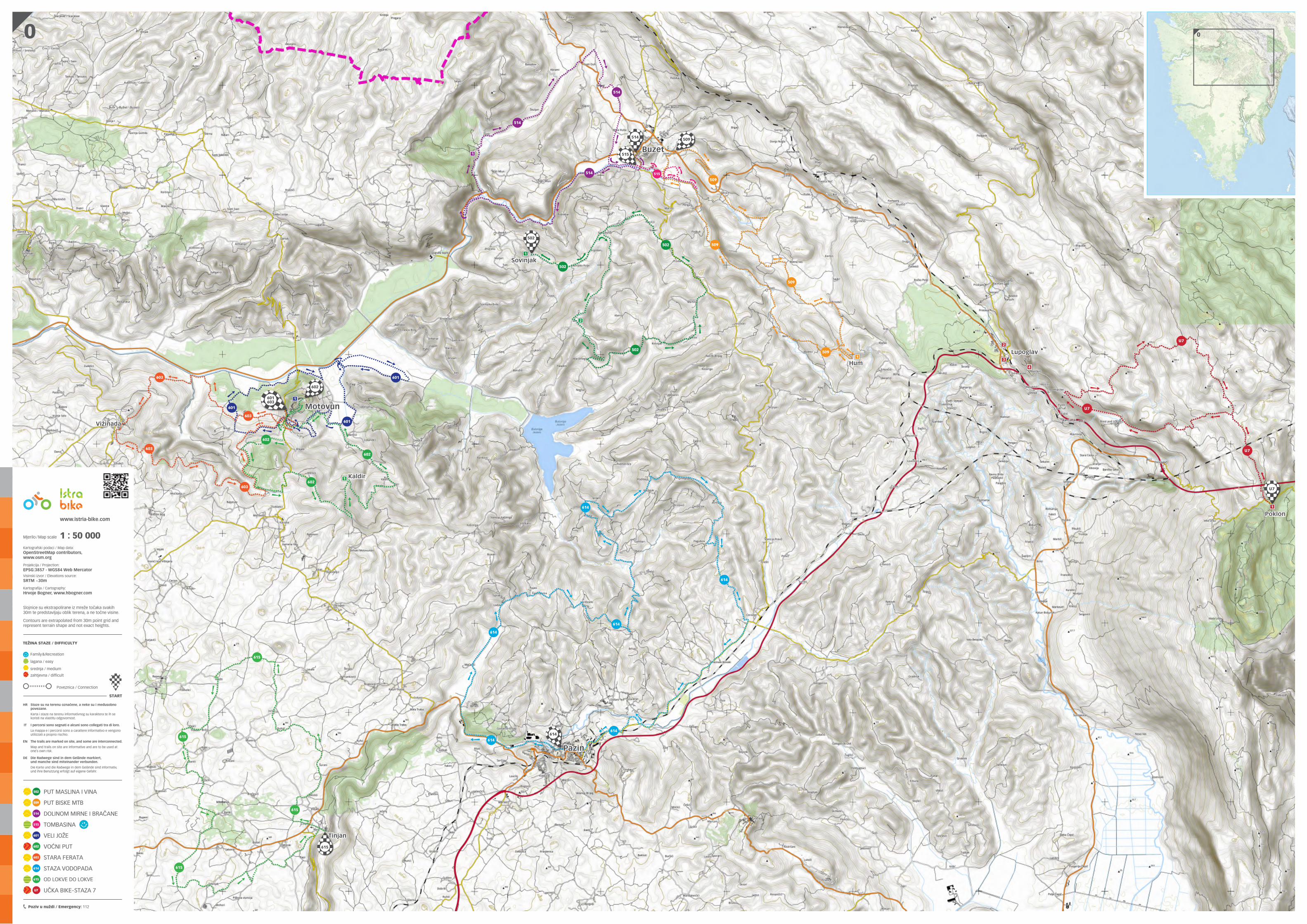
Mjerilo /Map scale 1 : 50 000
HR Staze su na terenu označene, a neke su i međusobno povezane.
Karta i staze na terenu informativnog su karaktera te ih se koristi na vlastitu odgovornost.
IT I percorsi sono segnati e alcuni sono collegati tra di loro.
La mappa e i percorsi sono a carattere informativo e vengono utilizzati a proprio rischio.
EN The trails are marked on site, and some are interconnected.
Map and trails on site are informative and are to be used at one’s own risk.
DE Die Radwege sind in dem Gelände markiert, und manche sind miteinander verbunden.
Die Karte und die Radwege in dem Gelände sind informativ, und ihre Benutzung erfolgt auf eigene Gefahr.
502 PUT MASLINA I VINA
509 PUT BISKE MTB
514 DOLINOM MIRNE I BRAČANE
515 TOMBASINA
601 VELI JOŽE
602 VOĆNI PUT
603 STARA FERATA
614 STAZA VODOPADA
615 OD LOKVE DO LOKVE
U7 UČKA BIKE-STAZA 7
TEŽINA STAZE / DIFFICULTY
Family&Recreation
lagana / easy
srednja / medium
zahtjevna / difficult
Poveznica / Connection