Embed Size (px)
DESCRIPTION
This is an Informational Book explaining weather...
Citation preview

Weather... What is It?
By: Vignesh J. And Nicole J.
995 × 822 - vectorjungle.com
700 × 470 - atmos.illinois.edu
640 × 480 - wanderer.com

What are the layers of the atmosphere and how does it affect weather?
● The troposphere is the layer closest to Earth, it 0-10 kilometers in elevation.
● The stratosphere sits on top of the troposphere and it is 11-25 kilometers.
● The mesosphere is 26-100 kilometers.● The thermosphere is the huge layer of the
atmosphere and ranges from 101-400 kilometers. this layer is like our shield and burns up meteorites! This is where the northern lights happen!

How was our atmosphere formed?The atmosphere was formed by the volcanoes released carbon dioxide which decided to mixwith the water. This water cooled and made rain. This rain fell down and destroyed the carbon dioxide. In this bigger, better ocean a plant called algae formed and created oxygen, the gas we breathe. This process repeated over, and over, and over again causing our atmosphere to form!

What is wind? Wind is a air motion caused by the uneven heating of the atmosphere.The equator gets hit with suns rays directly, this causes the air to get hot and rise forming wind currents at about 30 degrees north and South of the equator, where this hotair cools. ● Trade winds are breezes that move toward the equator.● Doldrums are wind slightly North of the
equator and are formed by the trade winds meeting. They are calm winds.
Wind currents

● Prevailing westerlies are located at 30 to 60 degrees latitude, they move toward the poles and to the East. They cause most of the weather in the USA and Canada.
● The polar easterlies occur at 60 degrees latitude and travel upward to the poles, when this air cools it goes away from the poles and formes the coriolis effect.
~Nicole
Wind Currents cont'd

Convection is when hot and cold things fight against each-other. This only happens because of the sun heating fluids, such as wind or water... This heating and cooling forms convection currents, which can happen in the air or in water. In the air this causes fronts, while in water this causes waves, and currents...
Convection

IsothermMap

You may be thinking what does that mean? Well an isotherm map uses lines across the area to display or show the surface temperature. The surface temperature is the temperature on the ground. This map connects points that have the same surface temperature. Now you know what an isotherm map is but what does isotherm mean? The word Isotherm comes form the word Isothermal which means a constant temperature.
Isotherm Map Explanation
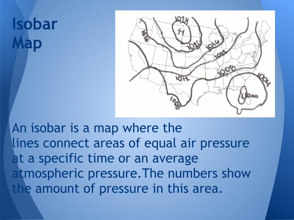
An isobar is a map where the lines connect areas of equal air pressure at a specific time or an average atmospheric pressure.The numbers show the amount of pressure in this area.
Isobar Map
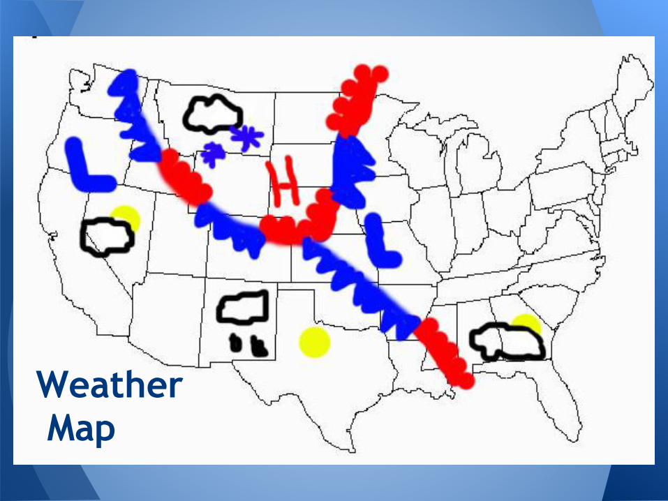
Weather Map

You may not even realize this, but you have probably already seen a weather map without even knowing... The red lines with the rounded edges show a warm front; while the blue lines with pointed ends show a cold front...The yellow circles show the sun, or cloudy days, or these can even have temperatures on them...
Weather Map Explanation
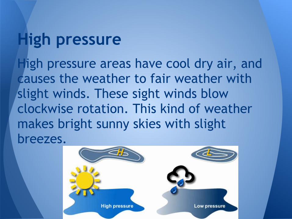
High pressure areas have cool dry air, and causes the weather to fair weather with slight winds. These sight winds blow clockwise rotation. This kind of weather makes bright sunny skies with slight breezes.
High pressure

Low pressure areas have warm moist air, and cause the weather to be bad weather areas with winds. These winds blow in a counter-clockwise rotation. This kind of weather makes stormy skies with heavy winds.
Low Pressure

What is a front? Well a front is a huge air mass that moves across the land and the ocean, they do bump into each other but normally don't mix. Why? because one has high density while the other has low density, causing them not to mix.The four types of fronts are cold fronts, warm fronts, stationary fronts ,and occluded fronts.
Fronts all 4 types

Cold fronts form when a cold air mass moves underneath a warm air mass forcing the warm air to rise. This kind of front brings Precipitation. A warm front forms when warm air moves over cold air, this brings light showers and humid air. In winter a warm front brings snow.
Cold and Warm fronts
● A stationary front is where to air masses meet but don't have enough force to move each other. Causes weather to become cloudy with precipitation.
● Occluded fronts form when cool air mass and cold air mass come together, the warm air caught between them and is forced upward.Makes the weather cloudy and snowy.
Stationary and Occluded fronts
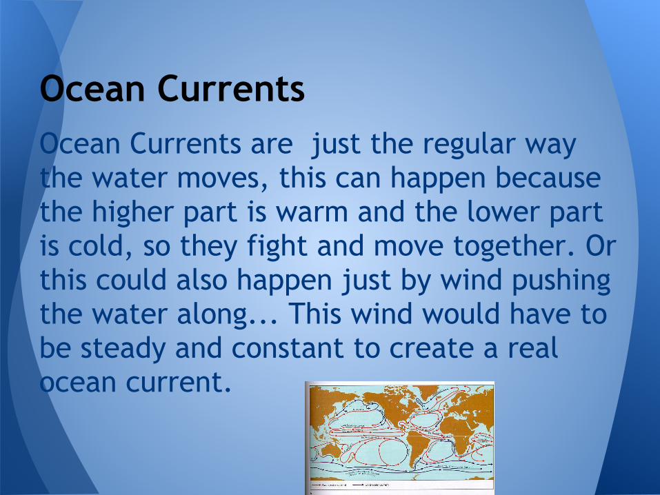
Ocean Currents are just the regular way the water moves, this can happen because the higher part is warm and the lower part is cold, so they fight and move together. Or this could also happen just by wind pushing the water along... This wind would have to be steady and constant to create a real ocean current.
Ocean Currents

A tornado is an intense rotating column of air that reaches from the ground to the thunderstorm in the clouds.These storms have winds up to 300 miles per hour! They can get up to a mile wide and 50 miles long creating a path of destruction. many tornadoes form from thunderstorms, they require warm, moist air from the gulf of mexico and cold dry air from Canada to form a tornado in America.
Tornados

A hurricane happens when air from surrounding areas with higher air pressure pushes in to the low pressure area. Then that "new" air becomes warm and moist and rises, too. As the warm air continues to rise, the surrounding air swirls in to take its place. As the warmed, moist air rises and cools off, the water in the air forms clouds. The whole system of clouds and wind spins and grows, fed by the ocean's heat and water evaporating from the surface.Storms that form north of the equator spin counterclockwise. Storms south of the equator spin clockwise. This difference is because of Earth's rotation on its axis.As the storm system rotates faster and faster, an eye forms in the center. It is very calm and clear in the eye, with very low air pressure. Higher pressure air from above flows down into the eye.The spinning air slowly turns into a very wet tornado...
Hurricanes

Precipitation is just a really long word for rain... but it cannot be called rain, since it also means anything that falls from the sky. What it actually is determined by the temperatures in the atmosphere. Suppose that it is very moist and warm, you will have rain. With very cold you will get hail, with cold you will get snow, and with mild you might get sleet.(Sleet is Uncommon)
Precipitation

There are three main types of clouds; Cirrus, Cumulus, and Stratus. Cirrus Clouds are delicate white strands of ice crystals that often form, what is referred to as mares tails. Cumulus Clouds are large, billowy cotton balls of clouds with dark bottoms and bright white tops that can reach 10,000 feet high. They may produce brief showers. And Stratus clouds are wispy clouds of fog that hang a few hundred feet above the ground and often bring drizzle.
Clouds

How exactly do scientists get images like this? Well, its actually quite simple... They just have satellites all up in our atmosphere, (which are also used for GPS) that take pictures of the ground from great heights and with very detailed cameras, providing a clean and precise photo...
Scientist Images

The sun provides us with many things...One of the main things that the sun provides us with,(besides light, and warmth) is energy, this energy is transferred through radiation, which is a method of heat transfer. This comes in many different forms; the forms are measured in wavelengths, this is just the length of the wave...Ultraviolet Light has the shortest wavelength, it then goes up through violet through many other colors and wavelengths until it gets to Red which has the second-longest wavelength, Infrared has the Longest wavelength. And the Shorter the wavelength the worse the light is for your eyes. Infrared isn't bad for your eyes at all while Ultraviolet can be...
The Sun and its Energy

A dew point is the temperature at which air becomes saturated and produces dew. This is the point where water vapor condenses into water droplets. This point rises when the temperature rises because hot air can hold more moisture.
Dew point

● Thermometer- used by scientist to measure the temperature they are normally glass tubes filled with mercury (a red fluid.)
● Barometer- shows air pressure, which helps to tell if the weather will be sunny or cloudy.
● Rain gauge- shows the amount of ● rain that has fallen.
Meteorological instruments used by scientist

● A sling psychrometer- measures relative humidity (how much water the air can hold) is made up of two thermometer and a wet cloth and if water on the cloth evaporates then one of the thermometers temperature will go down causing the scientist to know the relative humidity.● Wind vane- measures the direction the wind is blowing● Anemometer- measures wind speed with cups that turn the instrument, causing the dial to show the wind speed.● Weather maps- show large weather and atmospheric
changes.(look on page 10)● Hygrometer- measures the amount of water vapor in the
air a.k.a humidity● Weather balloon- measures the weather from higher up in
the atmosphere. ● Our eyes- one of the most accurate things for finding the current weather! they are almost always right!!

● http://www.williamsclass.com/EighthScienceWork/Atmosphere/HighLowPressure.jpg● https://encrypted-tbn0.gstatic.com/images?q=tbn:ANd9GcRF5klHZ-
iDXT_UMqKyiHNrch681rFGsWSHPf0XsinzYWaoN6RH● http://www.weatherwizkids.com/● http://www.vtaide.com/png/images/atmosphere.jpg● http://thumbs.dreamstime.com/thumblarge_508/12752096263cmT3Y.jpg● http://sfaulhafer.files.wordpress.com/2012/03/wind202.gif\● http://us.123rf.com/400wm/400/400/sermax55/sermax551010/sermax55101000013/7978058-
thermometer-icon.jpg● http://www.weatherwizkids.com/weather-instruments.htm● https://encrypted-tbn0.gstatic.com/images?q=tbn:ANd9GcRVaSvWjQCF-
M1WGvSWxLzsPNJMp_4U_nmAD2f1v9kIGh9Nn7YP● http://upload.wikimedia.org/wikipedia/commons/thumb/6/61/Wea00920.jpg/220px-
Wea00920.jpg● http://www.illustrationsof.com/royalty-free-eyes-clipart-illustration-223949.jpg● http://earth.usc.edu/~stott/Catalina/images/Oceanography/surface%20currents.jpg● http://www.weatherwizkids.com/
Bib.

Vignesh NicoleConvection AtmosphereWeather Maps WindsOcean Currents Iso-Therm+BarLow Pressure FrontsHurricane TornadoesPrecipitation Dew PointClouds InstrumentsSun High PressureScientist Images
Pictures
T-Chart