Embed Size (px)
Citation preview

Camp SEA Lab Teacher Resource Guide 100 Campus Center, Bldg 42, Seaside, CA 93955
831.582.3681 www.campsealab.org
Residential Outdoor School
Pre-Camp Teacher Resource Guide
Camp SEA Lab Teacher Resource Guide 100 Campus Center, Bldg 42, Seaside, CA 93955
831.582.3681 www.campsealab.org
2
Table of Contents
Introduction Teacher Time Ideas Camp SEA Lab Ecosystems & their Inhabitants Sandy Beaches Estuaries Common Organisms Before Camp SEA Lab
Activity 1: Apples & Oceans Activity 2: Only One Ocean Activity 3: Ocean Currents Activity 4: Build a Habitat & Creature Research
Introduction Hello and welcome to Camp SEA Lab’s Outdoor School program. As you begin to prepare your students for their Camp SEA Lab program, you may want to glance over the following curriculum guide to prepare your students for their visit. We depend on your students being adequately prepared for camp and the subjects we present, and being familiar with our vocabulary. Camp SEA Lab is for the students. The curriculum and schedule are based on this philosophy. Please try to keep this in mind as your program progresses. All lessons, evening programs, meals, and rules are conceived with the students’ interest, safety, and well-being in mind. The more time in preparation that you spend in the classroom before arriving on campus, the richer the experience can be for your students. This guide has been developed and designed to enhance the students’ program. Our goals at Camp SEA Lab are as follows: • Hands-on Education: We seek to get out campers out, on and in the waters around the central
coast. • Stewardship & Conservation: Campers gain knowledge and insight on the issues facing the marine
environment and Monterey Bay. • Emphasis in Career Development: Campers are exposed to many avenues that can lead them into a
marine science career. • Support Diversity: Our program is designed to serve all youth regardless of ethnic or socio-
economic background.
Camp SEA Lab Teacher Resource Guide 100 Campus Center, Bldg 42, Seaside, CA 93955
831.582.3681 www.campsealab.org
3
Teacher Time Ideas Teachers have an hour with their students each afternoon. This time can be spent in any way; however, we have some suggestions for activities. WRITING ACTIVITIES
• Write a letter home • Write a poem (see ideas in logbook) • Write letters to themselves or students in lower grade about camp; collect and re-distribute later • Write questions for an environmental quiz bowl and play the environmental quiz bowl in teams the
following day • Make up crossword puzzles/word searches from Camp SEA Lab vocabulary • Write about the different ways students had to change their life during Camp SEA Lab and how they
feel about it • Create a class newspaper or video project about the week. Students can write science articles,
interview each other or camp staff, and draw cartoons to represent aspects of their experience at Camp SEA Lab.
DISCUSSION & PUBLIC SPEAKING
• Share the day’s experiences • Discuss feelings about camp & living with classmates • Talk about any problems and discuss ways to solve them • Talk about ideas to promote cooperation • Discuss possible conservation projects to be undertaken at school • Have students sit alone for 10-15 minutes to observe nature, then share what each observed • Work on a debate or hearing on an environmental situation real or imaginary (this could be a good
post-activity) OTHER ACTIVITIES
• Environmental coat of arms (students divide a shield shape into quadrants. They will draw their representation of a different ecosystems or organisms they’ve encountered during Camp SEA Lab activities in each quadrant.
• Read or tell a story to your class • Play animal charades with individuals or groups • Play environmental Pictionary • Play the 60-second contest (students write as many new things new things they’ve learned as they
can to fit into categories you give them in 60 seconds) • Play 20 questions • Take a walk on the beach. (At least one teacher must accompany students to the beach and be
responsible for their safety while there.)

Camp SEA Lab Teacher Resource Guide 100 Campus Center, Bldg 42, Seaside, CA 93955
831.582.3681 www.campsealab.org
4
Ecosystems & their Inhabitants Sandy Beaches
Along the coast of Central California is the often-visited marine habitat of the sandy beach. The sand-covered area where the land meets the sea is a physically harsh habitat with only a small number of living organisms in comparison to other shoreline habitats. The daily ebb and flow of the tides and the action of waves and currents keeps water in constant motion, while below the sand shifts. The sandy beach begins underwater in the subtidal region, continues up through the crashing waves of the surf zone, into the swash zone where the waves cover and uncover the sand regularly, and extends to the cliffs or sand dunes. Specialized animals inhabit this turbulent habitat. The ability to move quickly to stay above the waterline or to burrow in the sand is a common adaptation among beach animals. Most beach animals make a living by filtering meals from the organic material that washes in with each wave. Beach organisms are vulnerable to human impact that often causes changes in physical environment. These changes can be the result of pollution, careless building, or overuse. Humans that interact with the sandy beach must be mindful of the factors that are important to its health. Sand and Water Beaches range from sand only to sand with cobbles or boulders. The slope of the beach and the size of the sand particles indicate the power of the waves that strike it. Steep slopes and larger-sized grains mean big waves. The high-energy beach is cleaned of the small particles because fast moving water can carry them easily. Wide, gradually sloped beaches have finer sand and smaller surf. The low energy beach allows finer grains to accumulate. The sandy beach can change appearance seasonally. Bigger waves during winter storms pull sand offshore to form bars, leaving behind only the larger gravel or cobble. When the gentler seas of summer return, sand is re-deposited on the beach. The day-to-day appearance of a sandy beach may not change, but it is always in motion. Each breaker lifts millions of grains from one spot and deposits them at another. When the prevailing wave direction strikes the beach at an angle, sand grains are deposited by the receding backwash a short distance down the beach in the direction of the wind. Life at the Sandy Beach One of the most difficult obstacles that sandy beach organisms face is the lack of stable ground on which to hold. It is a swim, burrow, or be swept away habitat. Burrowing beneath the sand protects animals from predation, wave impact, drying out, and extreme temperatures. Yet, life in the sand presents the problems of finding food. The sandy beach habitat provides little shelter or cover to avoid predation. During low tide, shorebirds, small mammals, and insects prey on sand crabs and other animals in the swash zone. High tide brings in another group of predators – fish, crabs, shrimp, and worms feed on the animals in the sand. Very little food grows in the sandy beach habitat. What photosynthesis there is at the sandy beach is from the microscopic algae in the top few centimeters of the sand. Most sandy beach animals depend on organic debris, called detritus, grown in other habitats. Kelp and other large algae are washed to the shore where they are broken into small pieces. Clams and crabs filter plankton and detritus kept suspended in the water by wave action for their food. In the spring when the upwelling of cold, nutrient-rich waters along the Pacific coast is at its highest, waves turn dark green indicating very abundant phytoplankton. When prevailing winds slacken or shift, the surf may carry a
Camp SEA Lab Teacher Resource Guide 100 Campus Center, Bldg 42, Seaside, CA 93955
831.582.3681 www.campsealab.org
5
brown froth often mistaken for pollution. This foam is the concentrated remains of phytoplankton. At the highest reach of the tide is beach wrack, where the debris from the ocean is left onshore. The beach wrack reflects what lives just offshore. Kelp and other algae are the biggest contributors to the wrack on the Central California beaches. Beach wrack also contains the dead and dying remains of fish, birds, and the formless masses of jellies. Small shrimp-like amphipods, commonly called beach hoppers, eat the rich food of beach wrack. Their gills function almost like lungs yet must be kept wet from the damp sand to function. In the Swash Zone Commonly called the sand crab, Emerita analoga is the epitome of burrowing efficiency. While other crabs are able to move in any direction, the sand crab can only move backwards. Its rear legs are modified as paddles, which gives it very good swimming capability, an essential skill when it is stirred out of the sand by crashing waves. The sand crab burrows tail first into the sand, with its head near the surface facing seaward. Only its eyes and antennae are held above the sand. When a wave recedes, its large antennae are unfurled to capture phytoplankton. The entire population moves up and down the beach with the tides. Beyond the Tides Though unseen by the beach stroller, there are several fish species that live in the sandy beach habitat. Skates, rays, and other flatfish patrol for prey just beyond the waves. When the tide is in, they have access to the inter-tidal crabs, clams, and worms. By flapping their “wings,” they create their own surf-like action to blow away the sand and expose their prey. Some fish feed just behind the leading edge of the breaking waves. Surfperch and sand eels take advantage of waves forces to grab crabs and worms otherwise unobtainable. Above the Tides Probably the most familiar birds of the sandy beach are the little Sanderlings. These are the birds that move like little wind-up toys, darting back and forth at the edge of the crashing surf. Sanderlings seem as anxious to avoid getting wet as they do to snatch an exposed mole crab or worm. They aren’t equipped to probe deep into the sand, so they try to find prey as it is stirred up by the waves and before it can re-burrow. The larger Willets with longer bills are less restricted to find loosened prey at the sand surface. The tips of their bills are sensitive and are able to feel tiny vibrations that indicate prey deeper in the sand. Higher on the beach small Snowy Plovers chase about in the dry sand and beach wrack to snatch insects and beach hoppers from the surface. The most noticeable birds of the beach, and certainly the loudest, are the gulls. These scavengers feed on most any food item tossed on the shore – whether by wave or human. Human Impact Beaches are in constant motion, with sand moving seasonally on and offshore and along the coast in the prevailing direction of wind and waves. A shoreline that moves 25 meters in 50 years gets noticed when it is near a man-made structure. Seawalls and groins have been used in the past to try to control the natural processes of erosion and deposition of sand. Building of structures in many coastal areas is controlled, because it is very hard to correctly predict how the sand and water will flow around the new structure. The sandy beach is a major deposition area for not only beach wrack but for anything that floats at the surface – debris from merchant vessels and uprooted trees. Plastic and garbage on the beach may be mistaken for food by birds. Oil from spills and chronic pollution washes onto sandy beaches and coats the sand grains and animals. Toxic chemicals in oil kill many animals and may pollute the sandy beach for years.
Excerpted from Gulf of the Farallones materials http://limpetsmonitoring.org/resources_sb.php
Camp SEA Lab Teacher Resource Guide 100 Campus Center, Bldg 42, Seaside, CA 93955
831.582.3681 www.campsealab.org
6
Ecosystems & their Inhabitants Estuaries
What is an estuary? There are a number of definitions for an estuary, primarily because there are so many types of coastal wetlands on Earth; here is one that is reasonably inclusive. An estuary is a partially enclosed coastal body of water, which is either permanently or periodically open to the sea. In addition, during some periods there is a measurable variation in salinity, due to the mixture of seawater with fresh water from land. This mixing may be continual, as in San Francisco Bay or the delta around the Mississippi River, or it may be seasonal, as in many southern California systems or many mangrove forests. For this discussion, let’s divide an estuary into two habitats, the mudflat and the salt marsh. The mudflat, sometimes called a tidal flat, is composed of mud and/or sand usually between the extreme low tide zone and the mid-high tide zone. Mud flats are created here because mud is composed primarily of very light, very small particles that only settle out in such calm, protected environments as an estuary. At least part of the mudflat is daily exposed with each low tide, though the lowest parts may only be exposed on very low tides. Most mudflats are bisected by channels, which contain either seawater or freshwater. Salt marshes are found adjacent to the mudflats from the mid-high tide zone to the extreme high tide line. Typically, salt marshes contain a number of salt tolerant plants, able to withstand at least some repeated immersion in salt water. How are they formed? Many estuaries in the United States, particularly along the East coast, have been formed by the combination of rising sea level and the subsidence of the land. These are often called “drowned river valleys” and Elkhorn Slough, Chesapeake Bay, and Hudson River Valley are good examples. Tectonic forces formed some Pacific Coast estuaries. San Francisco Bay filled with water because of faulting and subsidence of the land during earthquakes. Estuaries are also formed by the creation of shallow, wave-protected areas behind bay mouths or within river deltas. Whatever their cause, many of today’s estuaries were formed only recently, particularly over the last 10,000 years. Estuary Characteristics Shape: The extent of salt marsh and mudflat in an estuary is directly related to the area protected from wave action. Waves are the killers of salt marshes and mudflats; by briskly moving water about, they carry away the small particles of clay and organic matter, which form mud and which allow for the creation of salt marshes. The quieter the habitat, the more the lighter particles will settle out and the softer the mud will be. Fresh Water Input: The amount and timing of fresh water inflow, from rivers, streams or run-off, has a profound effect on an estuary and the organisms that live there. First, organisms that live in an area of high fresh water flow face severe osmotic problems. A body responds differently when in salt water (water tends to leave it), than in fresh (water tends to absorb into it). Organisms that live in estuaries with high, often seasonal or tidal, changes in fresh water levels have to be able to cope with these changes, often on a daily basis. Lots of fresh water also means that high levels of nutrients may flow into the system while the water is rushing in. High nutrient levels may or may not be a positive event for estuarine organisms. Nutrients feed many food chains, but on the other hand, some algae can produce toxins. Running fresh water can also have a flushing effect on a system, carrying off pollutants or decaying vegetation. It can also carry away the

Camp SEA Lab Teacher Resource Guide 100 Campus Center, Bldg 42, Seaside, CA 93955
831.582.3681 www.campsealab.org
7
lighter particles, which form mud, depositing instead heavier sand grains. This can completely alter the substrate and the substrate-dwelling organisms within an estuary. Tides: Tides are a major force in estuaries. They help dictate how long organisms are under water and, perhaps more importantly, how long they are exposed to predators and desiccation. Tides are rhythmic, predictable, periodic changes in the height of a body of water, caused by a combination of the pulls of the sun and moon, and the motion and terrain of the Earth. Throughout the year, tides vary in their heights and times. Tidal variability, over days, months and seasons, means that organisms which live in estuaries must be prepared to withstand exposure to the atmosphere and immersion in water (of varying salinities) as much as twice a day. Water Movement: There are three major circulation patterns, salt wedge, well-mixed, and reverse. In salt wedge estuaries, a rapidly flowing large river enters the ocean where tidal ranges are low or moderate. When this happens, the lighter fresh water tends to flow out to sea on the surface, and the heavier seawater flows into the estuary near the bottom (forming a salt-water wedge). Well-mixed systems occur when a river flows slowly or at low levels and where the tidal range is moderate to high. In this case, the tides stir the fresh and salt water together. When this occurs, water is saltiest at the ocean end of the estuary and becomes fresher towards the head of the system. Reverse estuaries form along hot, arid coasts, particularly lagoons, where there is little or no river flow. In these embayments, the seawater in the uppermost portions evaporates, causing water to flow in from the ocean. The result is that, compared to the water near the mouth, the salinity is actually higher in the upper reaches of the estuary. The Big Stewpot The point to remember about estuaries is that they are extremely productive. In concrete terms, this means that a great amount of plant life (algae, phytoplankton, seagrasses, mangroves, etc) thrives there and thus, all the organisms that eat, decay, rest in, or live on plants are very abundant. Why are estuaries some of the most productive environments on Earth? The most important reason is that estuaries are great nutrient sinks; they are continually filled with nutrients (nitrogen & phosphorus) plants need to grow and reproduce. Most of these nutrients come from the streams or rivers that empty into the estuaries. However what is a key factor in an estuary is that the slow-moving water allows the nutrients to be retained in the estuary, giving the attached plants and drifting phytoplankton a chance to absorb the nutrients. This allows for rapid and luxuriant plant growth, and if plants do well, the organisms that depend on them do well also. The massive amounts of nutrients and subsequent phytoplankton growth make an estuary an ideal location for larval organisms, which feed on phytoplankton. This is one of the reasons that estuaries tend to be nursery grounds for a wide variety of organisms. The fate of dead organisms in an estuary also increases the richness of that environment. In protected estuaries, dead organisms often remain in the system and enrich it. The high level of decomposition in an estuary leads to massive amounts of bacteria that, along with plants, form the basis of the estuarine food webs. There is so much bacterial activity in the sediments of estuaries that many organisms, particularly shrimp and worms, just eat mud. In fact, this rich, soupy, microorganism-rich mud is a major reason that estuaries are so loaded with life.
Excerpted from MARE Wetlands materials
“The Most Excellent MARE Teacher’s Guide to Wetlands” by Milton Love http://www.lawrencehallofscience.org/mare

Camp SEA Lab Teacher Resource Guide 100 Campus Center, Bldg 42, Seaside, CA 93955
831.582.3681 www.campsealab.org
8
Animals that might be seen while at Camp SEA Lab: Sandy beach ecosystem: Common Dolphin Delphinus delphis
Pacific Harbor Seal Phoca vitulina Southern Sea Otter Enhydra lutris CA Sea Lion Zalophus californianus
Sanderling Calidris alba Long-billed Curlew Numenius americanus Marbled Godwit Limosa fedoa Surf Scoter Melanitta perspicillata
Brown Pelican Pelecanus occidentalis Turkey Vulture Cathartes aura
Barred Surfperch Amphistichus argenteus Silver Surfperch Hyperprosopon ellipticum Pacific Sand Crab Emerita analoga
Spiny Sand Crab Blepharipoda occidentalis Beach Hopper or Sand Flea Orchestoidea californiana
Scud Amphipoda sp. Beach Pill bug Tylos punctatus Kelp Fly Coelopa vanduzeei Pile Worm Nereis succinea Blood Worm Euzonus mucronata Sea Gooseberry Jelly Pleurobrachia pileus Lewis's Moon Snail Polinices lewisii
Bean Clams Donax gouldi Basket Cockle Clinocardium nuttallii
Estuary Ecosystem: Pacific Harbor Seal Phoca vitulina Southern Sea Otter Enhydra lutris CA Sea Lion Zalophus californianus Double-crested Cormorant Phalacrocorax auritus Caspian Tern Hydroprogne caspia
Western Gull Larus occidentalis CA Gull Larus californicus Marbled Godwit Limosa fedoa
Brown Pelican Pelecanus occidentalis Rock Dove Columba livia Sanderling Calidris alba
Western Snowy Plover Charadrius alexandrinus Long-billed Curlew Numenius americanus Leopard Shark Triakis semifasciata
Bat Ray Myliobatis californica Moon Jelly Aurelia aurita
Purple-striped Jelly Chrysaora colorata Various phyto- & zooplankton
Scud Amphipoda sp. Ghost Anemone Metridium senile Club-tipped Anemone Corynactis californica Skeleton Shrimp Caprellid sp.

Camp SEA Lab Teacher Resource Guide 100 Campus Center, Bldg 42, Seaside, CA 93955
831.582.3681 www.campsealab.org
9
Activity 1: Apples & Oceans Excerpted and adapted from the MARE Teacher’s Guide to Ocean Currents
Full curriculum kit available for check-out from Camp SEA Lab
Background In this activity, students are introduced to our planet’s one, interconnected ocean; to the importance of the ocean to all life on Earth; and to the very limited resources we depend on from the land and sea. Most of our planet is covered by ocean, but only a small fraction of the ocean supports large concentrations of life.
Concepts: • Most of the planet is covered by water • People get food and water from the ocean • About ½ of the oxygen we breathe comes from plants in the ocean • The ocean plays a major role in moderating our climate. Without an ocean, the surface of our
planet would freeze at night and be too hot for most life to exist during the day.
CA Science Standards Ocean Literacy Standards 5th: 3a, 3d, 4a, 4b 1: a, c, e, h 6th: 2b, c, 4a, 5a-c, 5e, 6a, 6b 6: b, c
Activity 1: Brainstorming Materials: 7 sheets of chart paper, masking tape, colored markers. Optional: inflatable globe & ocean pictures Procedure: 1. Divide students into teams of 4-6. Prompt their ocean thinking by distributing globes, pictures of the
ocean, and posting posters. Play ocean sounds, if available. 2. Write the following questions on the board and ask each team to discuss them as you circulate:
a. What do you know and enjoy about the ocean? b. How do people depend on the ocean? c. What are the things people do that affect the ocean and the things that live there? d. What areas of the ocean do you think contain the most life? e. Where do you think are the best spots in the ocean to catch fish?
3. Have each team share and discuss their answers and record them on the board or chart paper. Try to draw out the ideas expressed in the Concepts list.
4. Pull out a globe and show the class the western hemisphere. Ask them what they can tell about the world from this perspective (i.e. big continents surrounded by water). Now, turn the globe to show the eastern hemisphere. Ask what this view tells about the world (i.e. most of the earth is covered by ocean).
Activity 2: Apples Materials: 1 each apple, knife, and plate per team. Optional: inflatable globe & laminated map
Procedure: 1. Make sure students are familiar with fractions and pie graphs. 2. Tell students that now they are going to find out even more information about the critical resources
that we depend on from the ocean. Hold up an apple and explain that they will use an apple to better understand the amount of resources available on our planet.
3. Pair students and set each team up with 1 apple, a knife, a plate, a paper towel, and colored markers. Keep a set to use for demonstration. As you demonstrate each step, have student pairs repeat your actions as you go, and use a pie graph on the wall to convert your steps into graph form.

Camp SEA Lab Teacher Resource Guide 100 Campus Center, Bldg 42, Seaside, CA 93955
831.582.3681 www.campsealab.org
10
4. Land: Cut your apple into four equal pieces from top to bottom. Three of those pieces represent the aquatic environment. (3/4 of the Earth’s surface is covered with water) Set these 3 pieces aside and mark these “ocean”. The remaining one fourth of the Earth’s surface is the terrestrial environment. Label this “land”.
5. Cut your land into 2 equal pieces. One piece represents all the land that is too dry, too wet, too cold or too hot for humans. Label this uninhabitable land. The other piece of land or 1/8 of the Earth’s surface is habitable by humans.
6. Cut your habitable land into four pieces. Set aside 3 of these pieces, the remaining piece, 1/32 of the Earth’s surface, represents the portion of the habitable land in which humans can grow food.
7. Take this 1/32 piece and cut off a thin slice. This represents 3/100 of 1% of the Earth’s surface. All of our drinkable water comes from this area. 99.5% of the fresh water on the Earth is locked up in ice caps and glaciers and is therefore unusable. Compare this piece of the apple with the entire apple to begin a discussion about the Earth’s finite resources and the need to protect the environment.
8. Ocean: Set the terrestrial part of the Earth aside and get the aquatic portions of your apple.
9. Take one of the quarters and cut it in half. This piece, 1/8 of the Earth’s surface, represents the productive zones of the ocean. Many regions of the world’s oceans are not very productive and support very little life. This small portion represents the amount of the ocean that can support life.
10. Cut this 1/8 piece in half. This 1/16 represents the most productive coastal zones of the ocean. This is where most commercial fishing takes place (think Deadliest Catch). Looking at this, you can see that only a tiny portion of the ocean produces most of the seafood we eat!
11. Cut this 1/16 portion in half to get a 1/32 piece. This represents the photic zone, the top 100 meters (300') of the ocean through which light can penetrate and support photosynthesis. Almost all of the ocean’s life is concentrated in this narrow surface region. Ask the students how we should treat our earth considering that only a small portion of the terrestrial and aquatic environments are capable of supporting the needs of more than 5 billion humans.
12. Now cut a tiny sliver off to represent ¾,000 of the world’s surface. This represents the six tremendously productive upwelling areas found within the coastal zone. Upwelling is a process that brings very cold, nutrient-rich water from deep down in the ocean up to the surface during certain seasons on the west coasts of six continents. These are the prime destinations for migrating birds and marine mammals, as they provide huge sources of food. The Central California coast is one of these upwelling regions, which explains our frequent whale sightings and our position on many migration routes. National Marine Sanctuaries have been created, in part, to protect upwelling areas.
13. Use a map or globe to show where these upwelling zones are: 14. Wrap-up: have students hold up the two smallest slices they saved. One sliver
represents our drinkable water, the resource necessary for all life on land; the other represents all the upwelling zones, among the most productive places on Earth. Ask students to compare and discuss the sizes of these slices compared to the whole. {These two pieces of our planet support nearly all of its life. They also represent the parts of the land and ocean that humans come in contact with, use, and affect the most. These two critical resources need to be protected to ensure a healthy future for our planet.}
15. Eat the apples! {Since there’s so little farmable land on which to grow our food, we might not want to waste what we get from it.}

Camp SEA Lab Teacher Resource Guide 100 Campus Center, Bldg 42, Seaside, CA 93955
831.582.3681 www.campsealab.org
11
Activity 2: Only One Ocean Summary: Students will determine that all of the world’s oceans are connected.
Student Learning Outcomes: Students will: • become oriented to the overall geography of the globe • become familiar with the connection points of the oceans • understand the concept that there is one, interconnected, world ocean
Materials:
• Inflatable Globes • Vis-à-vis markers
Directions and Procedure 1. (Optional) Discussion (10 minutes)
• Ask students to share what they already know about the ocean. They can use this time to share personal experiences, things they’ve read, and things they’ve seen on TV.
2. Global Exploration (20-30 minutes)
• Divide the students into the same number of teams as globes that you have. • Give each team one of the globes and give them a chance to explore it. Focus Questions (these questions can be given verbally or written on a dry erase board).:
1. Find a view of the Earth that shows mostly land. Which continents does it include? 2. Find a view of the Earth that shows mostly ocean. Which oceans does it include? 3. It’s often said that there are “seven seas”. How many do you find? 4. Can you find the line where the Pacific Ocean ends and the Atlantic begins? 5. Can you find the edges of the Antarctic Ocean?
• Using the globes, briefly discuss how to read lines of latitude and longitude. This will be covered more in depth later.
• Once they’ve finished exploring and are ready to focus, ask them to do the following (these questions can be given verbally or written on a dry erase board). These questions can be answered on a blank page in their journal.:
1. “See how far around the globe you can draw a line without lifting the pen. Now describe your longest route (the farthest you can go without lifting the pen) including where you started, where you ended, and the continents you crossed.” How many lines of latitude did they cross? How many lines of longitude?
2. “See how far around the globe you can draw a line without lifting the pen, always staying on water. Now, record in words the longest route you could find including a description of where you started, which bodies of water you went through, and which continents you passed by. “How many lines of latitude did they cross? How many lines of longitude?
3. What mode of travel would you use for your trip? 4. How long do you think it would take?
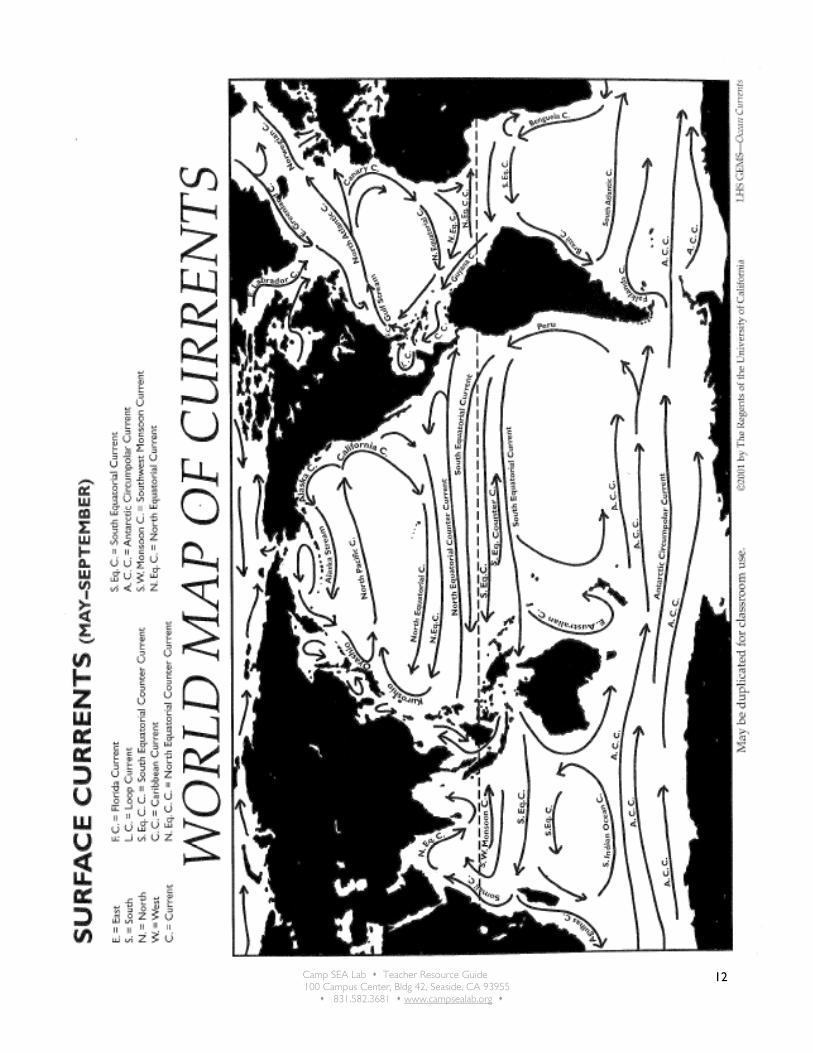
2. Discussion: During the next few activities, we’ll learn about how water moves between the different oceans. How do the students think this happens? Hand out or display a copy of the map that follows. Can any student find a path that a water molecule might follow with the currents all the way around the globe? How about a path that would take that molecule past each of the seven continents?
Camp SEA Lab Teacher Resource Guide 100 Campus Center, Bldg 42, Seaside, CA 93955
831.582.3681 www.campsealab.org
12
Camp SEA Lab Teacher Resource Guide 100 Campus Center, Bldg 42, Seaside, CA 93955
831.582.3681 www.campsealab.org
13
Activity 3: Ocean Currents (Optional: requires some advanced vocabulary & attention)
Summary: Students will determine that all of the world’s oceans are connected.
Student Learning Outcomes: Students will: • become oriented to some advanced ocean current vocabulary • become familiar with the concepts of upwelling and downwelling • understand some of the larger influences on ocean currents
Materials:
• Video & projector or TV/VCR • Handouts of the questions below & pencils
Background Info: Currents and Marine Life
Currents are powerful physical forces in the seas. They move water and heat around the globe, and help determine the chemical make-up of the water column. Currents also are a major factor in ocean ecosystems. Two types of current motion, upwelling and downwelling, strongly influence the distribution and abundance of marine life. Upwelling: Currents play a huge role in marine productivity, through a process called upwelling. Sea life is concentrated in the sunlit waters near the surface, but most organic matter is far below, in deep waters and on the sea floor. When currents upwell, or flow up to the surface from beneath, they sweep vital nutrients back to where they're needed most. Nowhere is the link between ocean circulation and productivity more evident than around Antarctica. There, strong currents pump nitrogen and phosphate up from the deep sea to fuel vast blooms of algae and other plants. These plankton are eaten by swarms of shrimp-like crustaceans called krill. Because of upwelling nutrients, krill are abundant enough to feed the largest animals on earth, baleen whales, as well as myriad penguins, seals, and seabirds. In fact, despite the harsh conditions, the biomass of Antarctic krill is thought to be greater than that of any other animal on Earth. Downwelling: The importance of upwelling to surface organisms is matched by the need of sea bottom life for downwelling, or the sinking of surface water. Surface water can be forced downward by the pressure of the “pile” of water that forms where currents converge or wind drives the sea against a coastline. But for bottom dwellers, the sinking of water caused by density changes is especially noteworthy. The global conveyer belt takes oxygen-rich surface water and flushes it through the deep sea. Without this renewal, the dissolved oxygen in bottom sediments and waters would quickly be used up by the decay of organic matter. Anaerobic bacteria would take over decomposition, leading to a build up of hydrogen sulfide. Few benthic animals would survive such toxic conditions. In the most extreme cases, a lack of downwelling may lead to mass extinctions. Paleontologists have suggested that 250 million years ago, deep circulation slowed nearly to a stop, and the ocean began to stagnate. Low oxygen, sulfide and methane-rich waters filled the ocean deeps and then spread onto the continental shelves, wiping out 95% of all marine species in the greatest extinction event in Earth history.

Camp SEA Lab Teacher Resource Guide 100 Campus Center, Bldg 42, Seaside, CA 93955
831.582.3681 www.campsealab.org
14
Instructions: In this activity, you will explore the differences between upwelling and downwelling. Study the graphics and photographs illustrating upwelling and downwelling, then answer the questions about each process. Maps of the world’s major surface and deep currents are included as resources to help you understand where and how upwelling and downwelling occur. Display or distribute the following questions (answers are available here: http://www.learningdemo.com/noaa/lesson08/l8la2_1.htm):
Upwelling
1. Most primary productivity in the ocean occurs in surface waters, but most of the organic matter is at the bottom of the sea. Explain.
2. What causes upwelling? 3. Why is nutrient upwelling so powerful around Antarctica? 4. What other conditions near the South Pole help plants to growth?
Downwelling
1. What causes downwelling? 2. Where does most downwelling occur? 3. Life on Earth nearly died out at the end of the Paleozoic Era 250 million years ago. At that
time, all of the continents had just come together to form a supercontinent called Pangaea, and a single superocean called Panthalassa. The global climate had warmed by several degrees, especially at the poles. How do you think these conditions might have affected ocean circulation, and led to low oxygen levels in the sea?
Information Video: Show the following video: http://www.learningdemo.com/noaa/lesson08.html and have students write down the answers as they discover them.

Camp SEA Lab Teacher Resource Guide 100 Campus Center, Bldg 42, Seaside, CA 93955
831.582.3681 www.campsealab.org
15
Activity 4: Build a Habitat & Creature Research Adapted from Ocean Immersion: Grade 5, Regents of the University of California, 2002
Overview: Students research ocean organisms and make presentations to the class. They compile an ecosystem field guide, then design and construct their organism to add to a 3D classroom ocean ecosystem. Students discover that the ocean is home to many different organisms that interact with one another as predators, prey, or competitors. CA Science Standards Ocean Literacy Standards 5th: 6a, g, I 6th: 5a, b, c 7th:b, d 5c, d, e, I; 6b Materials:
• Craft supplies (colored construction paper, plastic wrap, ribbons, colored tissue paper, blue and brown butcher paper, tempera paint, blue cellophane, pipe cleaners, etc.)
• Species List copies • Field Guide page copies • Ocean sounds or music & player (opt) • Tape, glue & staple
Key Concept; The open ocean is home to many different organisms that interact with one another as predators, prey, and competitors. Setting the Stage:
1. Choose which ocean ecosystem you’d like to focus this activity on and make several copies of a species list for that ecosystem. That ecosystem will be referred to as “(chosen ecosystem)” throughout this activity write-up.
a. Information on sandy beach and estuary is provided at the beginning of this packet. If you choose another ecosystem (e.g. Deep sea, open ocean), you’ll need to compile a list of organisms found in that ecosystem. You’ll want to include large and small organisms, as well as producers (e.g. kelp and sea grasses), predators, and prey organisms in your list.
2. Determine whether you’d like students to work alone or in pairs for this activity
3. Collect materials to be used in creating your 3D backdrop and creatures. Students can sometimes bring in great materials from home recycling, and such.
Introduction:
4. Review good interviewing and listening behaviors with students
5. Partner students in pairs or small groups. Partners will ask each other the following questions that will be posted on the board:
a. Describe what the words “(chosen ecosystem)” means to you? b. How is the “(chosen ecosystem)” different from other ocean habitats? c. What are all the “(chosen ecosystem)” organisms that you can think of? d. If you could be any “(chosen ecosystem)” animal, which one would you be and why? e. If you were a SCUBA diver, how would you describe what the “(chosen ecosystem)” looks like
and feels like to dive in? f. Why do scientists say, “There is only one ocean”? g. What questions do you still have about the “(chosen ecosystem)”?
6. Debrief as you go or at the end of the sharing activity. Record responses to #3 and #7
7. Tell students they will be creating their own “(chosen ecosystem)” and a field guide to that ecosystem. If you have chosen an ecosystem not covered while at Camp SEA Lab, show students a video that will introduce the class to the “(chosen ecosystem)”. Many videos are available for checkout from Camp SEA Lab.

Camp SEA Lab Teacher Resource Guide 100 Campus Center, Bldg 42, Seaside, CA 93955
831.582.3681 www.campsealab.org
16
a. During the video, have students take “field notes” on the following:
• Count the number of organisms • List the names of organisms (called a Sighting List) • Choose 3 organisms and describe where you saw each organism in the ocean (bottom, mid-
water, surface) • Describe the actions of the 3 organisms • Describe interactions between your 3 organisms and other organisms in the video • Sketch the habitat • Sketch an organism
b. Give students a few minutes to discuss what they saw
c. Once the sketches are completed, post them on the wall and allow students to see what their classmates have drawn. These drawings can be used as inspiration for the final backdrop
d. Lead a class discussion and list on the board all the organisms from the students’ notes. Have students help you make a cluster diagram from the species list, grouping together organisms with like characteristics. Possible clusters could include animal groups, algae groups, zones, colors, or sizes.
e. Add any organisms that your students found to be important to your species list Setting the Stage:
8. Tell students they are now ready to discuss the design of their 3D version of their “(chosen ecosystem)”. Have students work in cooperative groups, with one student acting as recorder, to discuss the following questions:
• Which animals should be included? • Where should it be located? (our room, hallway, etc) • What are the possibilities for the overall design? (overhead, in a corner, along the side, etc) • Will it be actual size, or at a smaller scale? • What materials in the classroom can we use? • What materials do we need to find? • What else do we need to decide?
9. Record and discuss ideas with the class as a whole
10. Once that conversation is completed and students have moved on the their research stage, you can begin creating the backdrop. The simplest way is to use large pieces of colored butcher paper. String can be strung in front of this or across the ceiling to create a more 3D feel. Hang strips of blue or brown cellophane to create water or sand layers and/or hang the organisms from the string to show more depth.
Researching the Organisms:
11. Distribute copies of the species list to student pairs or individuals and give them time to look though the information.
12. Have each pair or individual decide on an organism they would like to know more about. Have them limit their exploration at first to one or two organisms so they can go into greater depth.
13. After everyone has chosen (or been assigned) an organism(s), have them tell the rest of the class which organisms they are interested in and why. Individuals or pairs of students choosing the same organism may like to join together to share information and resources.
14. Ask the class if there are any important organisms that were not chosen. Make a list of these organisms and have the class determine if they are important enough that they should not be left out. Ask if there are volunteers to work on these creatures.

Camp SEA Lab Teacher Resource Guide 100 Campus Center, Bldg 42, Seaside, CA 93955
831.582.3681 www.campsealab.org
17
15. Have students undertake their research (library, internet, or classroom reference books) to answer the questions about their organism and fill in their page of the class field guide.
* Consider the source! Ask students how they might know information they are getting from the internet is reliable. You can usually assume it is reliable if it is taken from a museum or university, etc. Remind students that anyone can make a web page – whether that person is an expert or not.
16. Collect the pages and compile them into a binder or notebook, to be used as the class Field Guide Construction:
17. Tell students that they can now design a 3D version of their organism to put in the “(chosen ecosystem)”. Describe the classroom materials available for them to use and remind them to make their organism the correct relative size as decided by the class. If their organism is very tiny, they may choose to put in under a paper magnifier for the diorama.
18. Discuss with the students their ideas before they start on the actual product. Tell them they will need to decide how many copies of their organism they should make for their “(chosen ecosystem)” to be realistic (e.g. if a student is building a sardine, that is a schooling fish and would not be found alone for very long. That student would want to find a way to build several sardines to create a school of them). They should also determine if their organism is so connected with other organisms that they need to work together with other students (e.g. krill and blue whales)
19. Models may be presented to the class once finished, or simply placed into the ecosystem.

Camp SEA Lab Teacher Resource Guide 100 Campus Center, Bldg 42, Seaside, CA 93955
831.582.3681 www.campsealab.org
18
Ocean Organism Field Guide Classification Common Name
Scientific Name
Phylum & Class
Who are some of its closest relatives and what do they all have in common?
Ecological Relationships What does it eat and how does it capture its food?
Who eats it and how does it escape being eaten?
Name 3 other organisms it interacts with:
Range and Distribution In what habitats can this organism be found?
Where does it live within its habitat? (attached to objects, free swimming in mid-water, etc.)
Other Information Do people use this organism in any way? What ways?
What else did you find interesting about this organism?
What resource materials did you use to find information? How do you know that your source of information is reliable?
Characteristics Size & Shape
Color & Patterning
Other distinguishing characteristics (number of legs, shell, scales, etc)

Camp SEA Lab Teacher Resource Guide 100 Campus Center, Bldg 42, Seaside, CA 93955
831.582.3681 www.campsealab.org
19
Creature Feature Draw your organism, its habitat, and label its parts below