Embed Size (px)
Citation preview
n¢
p
pp
p
p
p
p
p
p
p
p
pp
p
p
p
p
pp
p
p
p
p
p
p
p
p
p
p
!
!.
!R
!R
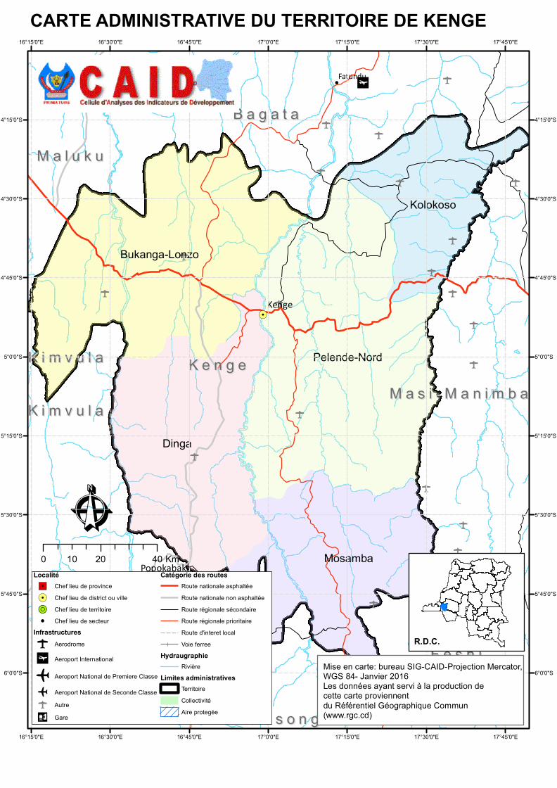
Dinga
Pelende-Nord
Mosamba
Bukanga-Lonzo
Kolokoso
K e n g eK e n g e
B a g a t aB a g a t a
P o p o k a b a k aP o p o k a b a k a
F e s h iF e s h i
M a l u k uM a l u k u
K a s o n g o - L u n d aK a s o n g o - L u n d a
K w a m o u t hK w a m o u t h
M a s i - M a n i m b aM a s i - M a n i m b aK i m v u l aK i m v u l a
K i m v u l aK i m v u l a
Kenge
Popokabaka
Fatundu
17°45'0"E
17°45'0"E
17°30'0"E
17°30'0"E
17°15'0"E
17°15'0"E
17°0'0"E
17°0'0"E
16°45'0"E
16°45'0"E
16°30'0"E
16°30'0"E
16°15'0"E
16°15'0"E
4°15'0"S 4°15'0"S
4°30'0"S 4°30'0"S
4°45'0"S 4°45'0"S
5°0'0"S 5°0'0"S
5°15'0"S 5°15'0"S
5°30'0"S 5°30'0"S
5°45'0"S 5°45'0"S
6°0'0"S 6°0'0"S
CARTE ADMINISTRATIVE DU TERRITOIRE DE KENGE
ÊLocalité"/ Chef lieu de province!. Chef lieu de district ou ville!R Chef lieu de territoire! Chef lieu de secteur
Infrastructuresp Aerodrome
n¢ Aeroport International
o Aeroport National de Premiere Classe
o Aeroport National de Seconde Classep Autre
n¤ Gare
Catégorie des routesRoute nationale asphaltéeRoute nationale non asphaltéeRoute régionale sécondaireRoute régionale prioritaireRoute d'interet localVoie ferree
HydraugraphieRivière
Limites administrativesTerritoireCollectivitéAire protegée
Mise en carte: bureau SIG-CAID-Projection Mercator, WGS 84- Janvier 2016Les données ayant servi à la production de cette carte proviennent du Référentiel Géographique Commun (www.rgc.cd)
0 20 4010 Km
R.D.C.