Embed Size (px)
Citation preview
Rapid Assessment of Circum-Arctic Ecosystem Resilience (RACER)
WESTERN GREENLAND
WWF Report
WWF – Denmark, May 2014
Ilulissat, West Greenland. Photo: Eva Garde
2
Report Rapid Assessment of Circum-Arctic Ecosystem Resilience (RACER). Western Greenland. Published by WWF Verdensnaturfonden, Svanevej 12, 2400 København NV Telefon: +45 35 36 36 35 – E-mail: [email protected] Project The RACER project is a three-year project funded by Mars Nordics A/S. This report is one of two reports that are the result of the work included within the project. Front page photo Ilulissat, West Greenland. Photo by Eva Garde. Author Eva Garde, M.Sc./Ph.D in Biology. Contributors Nina Riemer Johansson, M.Sc. in Biology, and Sascha Veggerby Nicolajsen, bachelor student in Biology. Comments to this report by: Charlotte M. Moshøj. This report can be downloaded from: WWF: www.wwf.dk/arktis
3
TABLE OF CONTENT
RAPID ASSESSMENT OF CIRCUMARCTIC ECOSYSTEM RESILIENCE 4
FOREWORD 5
ENGLISH ABSTRACT 6
IMAQARNERSIUGAQ 7
RESUMÉ 9
A TERRESTRIAL STUDY: WESTERN GREENLAND 10
KEY FEATURES IMPORTANT FOR RESILIENCE 13
ECOREGION CHARACTERISTICS 18
RACER EXPERT WORKSHOP, JANUARY 2014 21
KEY FEATURES 24
1. INGLEFIELD LAND 25
2. QAANAAQ AREA/INGLEFIELD BREDNING 27
3. THE NORTHWEST COASTAL ZONE 29
4. SVARTENHUK PENINSULA, NUUSSUAQ PENINSULA AND DISKO ISLAND 33
5. LAND AREA BETWEEN NORDRE STRØMFJORD AND NORDRE ISORTOQ FJORD 36
6. THE PAAMIUT AREA 38
7. INLAND NORDRE STRØMFJORD AREA 41
8. INNER GODTHÅBSFJORD AREA 43
9. GRØNNEDAL AREA 45
10. SOUTH GREENLAND 48
APPENDICES 50
LITERATURE CITED 59

4
RAPID ASSESSMENT OF CIRCUMARCTIC ECOSYSTEM RESILIENCE
WWF’S RAPID ASSESSMENT OF CIRCUMARCTIC ECOSYSTEM RESILIENCE (RACER) presents a new tool
for identifying and mapping places of conservation importance throughout the Arctic.
Recognizing that conservation efforts targeting the vulnerability of arctic habitats and species are not
keeping pace with accelerating climate change, RACER instead locates sources of ecological strength.
RACER finds places that generate what scientists call ecosystem resilience to fortify the wider
ecological regions in which these places are found. RACER then looks ahead to whether these
wellsprings of resilience will persist in a climate-altered future.
The RACER method has two parts. The first part maps the current location of land or sea features (such
as mountains, wetlands, polynyas, river deltas, etc.) that are home to exceptional growth of vegetation
and animals (productivity) and varieties of living things and habitats (diversity). These key features are
especially productive and diverse because the characteristics that make them up (e.g., the terrain of
mountains or the outflow at river mouths) act as drivers of ecological vitality. The exceptional vitality
of these key features–in the places where they are currently found–is what makes them local sources
of resilience for the ecosystems and ecosystem services of their wider regions (ecoregions). The
second part of RACER tests whether these key features will continue to provide region-wide resilience
despite predicted climate-related changes to temperature, rain, snowfall, sea ice, and other
environmental factors important to living systems. Changes to these climate variables affect the
drivers of ecological vitality (which depend on these variables) at key features. RACER uses forecast
changes to these climate variables to predict the future vitality of key features and the likely
persistence of ecosystem resilience for arctic ecoregions through the remainder of this century.
RACER's new method focuses conservation and management attention on the importance of
minimizing environmental disturbance to places that are–and will be for the remainder of this century
– sources of ecosystem resilience in the Arctic. In particular, RACER’s ecosystem-based approach
equips resource managers and conservationists with new targets for their efforts–managing not just
our impact on species and habitats but on the combinations of geographical, climatic, and ecological
characteristics that drive ecosystem functioning in the Far North. Identifying the sources of resilience
for region-wide arctic ecosystems and nurturing them into the future may be the best hope for the
survival of the Arctic’s unique identity—including its habitats, plants, animals and the ecological
services that northern people and cultures depend upon.
Source: Christie, P. and Sommerkorn, M. 2012. RACER: Rapid Assessment of Circum-Arctic Ecosystem
Resilience, 2nd ed. Ottawa, Canada: WWF Global Arctic Program. 72 pp.
5
FOREWORD
The Greenland nature, wildlife and human way of life are unique to the Arctic regions. The nature in
these remote regions is as grand and harsh as it is delicate and vulnerable – vulnerable to changes and
to disturbances. The Arctic wildlife is exceptional and so well adapted to the cold and icy elements of
this part of the world that changes in the environment can have severe impacts, in worst case fatal, on
the populations living here. Also the traditional way that people have lived for centuries in the Arctic is
threatened by climate change and new developing industries. The nature and wildlife of the Arctic
deserve to be safeguarded into a future of change, so that all of our children’s children also can enjoy
the rare wonders of the Arctic.
This report puts focus on terrestrial West Greenland, a region we call the Western Greenland
ecoregion. This ecoregion stretches from the southern tip of Greenland to the most northerly locations
in the high Arctic. The region is home to a variety of flora and fauna species including endemic Arctic
species as well as more temperate species. The Greenlandic people, inhabiting the region, are
dependent on the living resources harvested here. They fish in lakes and streams, hunt near towns
and settlements or in more remote locations far from the beaten track, and collect edible wild plants
and berries. These traditional activities contribute significantly to the income of the many families
living in small and larger settlements in Western Greenland. Today, Greenland faces new
developments as changes in climate allows for new industrial activities, e.g. mineral extraction. Often
these developmental activities are placed in areas essential for the Arctic wildlife and near traditional
hunting and fishing grounds, potentially creating conflicts of interests.
This report points at ten areas within the terrestrial Western Greenland ecoregion that show above-
average productivity and diversity. We hope with this report to put focus on these ten terrestrial areas
in Western Greenland and that the results will be useful as a contribution to designation of important
nature areas in Greenland. Relevant issues to discuss include:
• During the course of data collection and analyses for this report we realized that there is a general
knowledge-gap regarding the terrestrial ecosystems in Greenland. We therefore suggest further
scientific research in terrestrial biological and physical conditions as well as mapping of traditional
land-use that can be used in designation and conservation of important land areas in Western
Greenland. The ten designated areas in this report can be used as input and inspiration for selection of
such important land areas.
• Improved public involvement in mineral resource activities and mining projects.
• Long-term management plans that ensure sustainable use of the land and its resources.
• Establishment of zones without any mining activities within designated conservation areas.
Gitte Seeberg, CEO WWF Denmark
6
ENGLISH ABSTRACT The Western Greenland ecoregion is the stretch of land from the tip of Greenland in the south at Kap
Farvel (60°N) to the far north of Greenland at Inglefield Land (78°N). It lies in between the Greenland
Ice Cap and the marine West Greenland Shelf and covers more than 2000 km from low Arctic areas in
the south to High Arctic areas at the top of the world. The region spans three climatic zones: subarctic,
low Arctic, and high Arctic, and large differences in climate, soil conditions, and ecosystems are found
within the region. Also, Greenland is intersected by the Arctic Circle why there is considerable variation
in day length and light conditions across the region. Primary productivity on land in Greenland is
limited by low summer temperatures and a short growing season. Across the ecoregion as well as
locally there are large differences in climate and topography and the magnitude of net primary
productivity and distribution of flora varies greatly as a consequence.
The ecoregion is home to a variety of fish, birds, and mammals, from annually migrating species
to indigenous species. Among the terrestrial mammals, indigenous species include e.g. caribou
(Rangifer tarandus), Arctic hare (Lepus arcticus) and Arctic fox (Alopex lagopus), whereas the musk ox
(Ovibos moschatus) originally were introduced from East Greenland to West Greenland, where it now
thrives at various places throughout the region.
Inuit peoples have inhabited West Greenland for millennia, where they have lived off the land
and sea. In recent years, there have been a growing interest in industrial developments and mining
activities for iron, gemstone, gold, and rare earth minerals are either up-and-running or about to
become a reality. Also recreational human activity on land and on sea is increasing. These new human
activities pose a potential risk for the vulnerable Arctic habitats, the sensitive vegetation, some of the
animal populations, and the traditional way of life in Greenland.
The present RACER report of the Western Greenland ecoregion involves analysis of satellite
remote sensing data, relevant scientific literature and reports, and expert evaluation. The data used
reflects landscape heterogeneity, biodiversity, and the location of local communities. Ten terrestrial
key features have been identified based on their medium or high levels of productivity, their varied
topography/landscape heterogeneity, and/or more direct evidence of high biodiversity. As such the
ten key features represent sites of potentially conservation importance. The ten designated key
features are: 1. Inglefield Land; 2. Qaanaaq area/Inglefield Bredning; 3. The Northwest Coastal Zone; 4.
Part of Svartenhuk peninsula, Nussuaq peninsula, Disko Island; 5. Coastal land area between Nordre
Strømfjord and Nordre Isortoq fjord; 6. Paamiut area; 7. Inner Nordre Strømfjord area; 8. Inner
Godthåbsfjord area; 9. Grønnedal area; and 10. South Greenland. An evaluation of the likelihood that
key features will continue to contribute to region-wide resilience for the next century was not included
in this report as it was concluded that this was not feasible due to insufficient data and a general
knowledge-gap regarding the terrestrial ecosystems in Greenland.
The designated key features and the results within this report are intended to inform discussions
about the best management approaches to safeguard the productivity and diversity of these unique
places in Western Greenland.

7
IMAQARNERSIUGAQ
Kalaallit Nunaata kimmut sineriaata nunataani uumasoqatigiiaarfik, kujataani Nunap Isuaniit
(Avannarpasissuseq 60°N) avannarpasinnerpaaq Inglefield Land (Avannarpasissuseq 78°N) tikillugu,
Kalaallit Nunaata kimmut sineriaata avataani uumasoqatigiiaarfik, Sermersuup nunavissuullu kimmut
killingata akornaniittoq, 2000 kilometerinik isorartussuseqarpoq. Nunap immikkoortortaa tamanna
silap pissusaa naapertorlugu pingasunut immikkoortiternikuuvoq: Issittup kiannerulaartortaa kiisalu
Issittorsuaq Avannarleq Kujallerlu, nunamilu tamaani silap pissusaa, nunami pissutsit
uumasoqatigiiaallu eqqarsaatigalugit annertuumik assigiinngissuseqarput. Kalaallit Nunaata qeqqani
avannarpasissuseq 66°N Qaasuitsup avannamut killeqarfigaa, taamaammallu nunap immikkoortortaani
taakkunani ullukkut qanoq sivisutigisumik qaamasarnera qanorlu qaammaaritsigisarnera
eqqarsaatigalugit pissutsit assigiinngeqalutik. Kalaallit Nunaata killeqarfiata iluani nunavissuarmi,
tunngaviusumik uumassuseqarfiusumi aasakkut nillertarnera pissutigalugu, piffissaq uumassusillit
naaniarfigalugulu kinguaassiorfigisinnaasaat sivikitsuararsuusarpoq. Nunap immikkoortortaani
sumiiffinni assigiinngitsuni pissutsit nunallu qanoq iluseqarnera assigiinngeqimmata, sumiiffinni
assigiinngitsuni uumassusillit pingaarnertut tunngaviusumik naasarlutillu kinguaassiortartut qanoq
annertutigisumik naallutillu kinguaassiortigisarnerat assigiinngeqaaq.
Kalaallit Nunaata kitaani aalisakkat, timmissat miluumasullu assigiinnitsorpasuupput, taakkualu
ilaat ukiut tamaasa kiannerusumut kujavartertarput ilaalli avannaaniiginnartarlutik. Nunataani
miluumasut soorlu tuttut (Rangifer tarandus), ukallit (Lepus arcticus) teriannissallu (Alopex lagopus)
tamarmik avannaaniiginnartuupput umimmaallu (Ovibos moschatus) Tunumiit Kitaanut
nuunneqarnikut Kitaata kujasinnerusuani immikkuutitaarlutik peqqillutik kinguaassiortuarput.
Naggueqatigiit Inuit Kalaallit Nunaata kitaani ukiuni tusintilinni arlalinni najugaqarlutik nunami
immamilu uumasunik isumalluuteqarsimapput. Ukiuni kingullerni Kalaallit Nunaanni
suliffissuaqarnikkut ineriartortitsinissaq soqutigineqaraluttuinnarpoq taamaammallu saviminissaq,
ujaqqat erlinnartut, kuulti nunalu qaqutigoortunik akulik atorluarniarlugit ingerlataqalerniarnerit ilaat
piviusunngoreerput ilaallu piariilerlutik. Sukisaarsarnermut atatillugu nunami imaanilu aaqqissuussat
aamma amerliartorput. Suliniutit tamakkua tamarmik issittumi uumassusilinnik naasunillu
sunnerneqariaannarnik assigiinngiiaanik kiisalu inuiaat piniarnermikkut inooriaatsimikkullu ileqquinik
nalorninartorsiortitsilersinnaapput.
Kalaallit Nunaata kimmut sineriaani sumiiffinni assigiinngitsuni qulini uumassusillit qulinut
immikkuutitaarneranni qaammataasatigut, ilisimatuussutsikkullu paasissutissatigut nalunaarusiatigullu
tunngavilersuutaasinnaasut, kiisalu immikkut ilisimasallit naliliineri aallaavigalugit
misissueqqissaarnerit matumani nalunaarusiarineqarput. Nunap ilusaata assigiiaarneranut,
uumassusillit assigiinngitsut amerlassusaannut kiisalu inuit najugaqarfigisaasa sumiinnerinut
paasissutissat tunngavigineqarput. Nunap immikkoortortaani qulini uumassusullit suuneri qanorlu
kinguaassiortigisarneri kiisalu nunap ilusaata assigiiaarnera/assiga kiisalu/imalt. uumassusillit
assigiinngiiaat amerlassusaat, immikkoortitaarinermi nalilersuutigalugit toqqartuisoqarpoq. Tamakkua
tunngavigalugit nunap immikkoortortai toqqarneqartut qulit eriagisassatut
8
naliliiffigisariaqalersinnaapput. Sumiiffiit assigiinngitsut taakkua tassaapput: 1. Avanersuarmi Inglefield
Land; 2. Qaanaap eqqaani/timaani ikeq Inglefield Bredning; 3. Kalaallit Nunaata avannaata-kitaani
sineriammut qanittoq; 4. Sigguup ilaa, Nuussuaq Qeqertarsuarlu; 5. Nassuttuup Isortullu akornanni
nuna avasinneq; 6. Paamiut eqqaa; 7. Nassuttuup timaa; 8. Nuup Kangerluata timaa; 9. Kangilinnguit
eqqaat; kiisalu 10. Kalaallit Nunaata kujasinnersaa. Silap pissusaata allanngornera pissutigalugu
sumiiffinni taakkunani qulini pissutsit allanngorsinnaanerannut paasissutissat
tunngavigineqarsinnaasut naammanngitsutut nalilerneqarmata, kiisalu nunavissuarmi Kalaallit
Nunaata inissisimaffiani pinngortitami ataqatigiinerit ataatsimut isigalugit ilisimasakippallaarneq
pissutigalugu, nalunaarusiami matumani naliliisoqanngikkallarpoq.
Sumiiffiit matumani toqqarneqartut nalunaarusiamilu matumani inerniliinernut allanut
tunngavigineqartut aallaavigalugit, Kalaallit Nunaata kitaani sumiiffinni uumassusillit
kinguaassiortuarnissaat assigiinngiiaartullu immikkuullarissut ikiliartunnginnissaat qulakkeerniarlugit,
ingerlatsinermi periuseriniakkat oqallissigineqarsinnaapput.

9
RESUMÉ
Den terrestriske Vestgrønlandske økoregion er landstrækningen fra spidsen af Grønland i syd ved Kap
Farvel (60°N) til den nordligste del af Grønland ved Inglefield Land (78°N). Denne landstrækning ligger
mellem Indlandsisen og den marine Vestgrønlandske kontinentalsokkel økoregion og dækker et
område på mere end 2000 km fra lav arktiske egne syd til høj arktiske egne i nord. Regionen dækker
tre klimazoner: sub Arktis, lav Arktis og høj Arktis, og på tværs af regionen findes store forskelle i klima,
jordbundsforhold og økosystemer. Polarcirklen gennemskærer Grønland ved 66°N, og der er således
stor variation i dagslængde og lysforhold indenfor regionen. Den terrestriske primærproduktivitet i
Grønland er begrænset af lave sommertemperaturer og en kort vækstsæson. På grund af de store
regionale, såvel som lokale, forskelle i klima og topografi er graden af netto primærproduktionen og
fordelingen af vegetationen over regionen varierende.
Vestgrønland er hjemsted for mange forskellige arter af fisk, fugle og pattedyr, hvoraf nogle
migrerer til området hvert år fra sydligere egne og andre er oprindelige, hjemmehørende arter. Blandt
landpattedyrene, omfatter hjemmehørende arter for eksempel rensdyr (Rangifer tarandus), snehare
(Lepus arcticus) og polarræv (Alopex lagopus), mens moskusoksen (Ovibos moschatus) oprindeligt blev
introduceret fra Østgrønland til Vestgrønland, hvor den nu trives flere steder i regionen.
Inuit har været bosat i Vestgrønland i årtusinder, hvor de har ernæret sig af de levende
ressourcer på land og til vands. I de senere år har der i Grønland været en stigende interesse indenfor
industriel udvikling og minedrift efter jern, ædelsten, guld og sjældne jordarter er allerede en realitet
eller er ved at blive det. Også rekreative aktiviteter på land og til vands er stigende. Alle disse nye tiltag
udgør en potentiel risiko for de sårbare arktiske økosystemer og den arktiske vegetation, for nogle af
dyrebestandene og for den traditionelle levemåde i Grønland.
I denne rapport er anvendt analyser af satellitdata, relevant videnskabelig litteratur og rapporter
samt ekspertvurderinger til udpegelsen af ti områder indenfor den Vestgrønlandske økoregion. De
anvendte data afspejler heterogenitet i landskabet, biodiversitet, og placering af lokalsamfund. De ti
terrestriske udpegede områder er blevet identificeret ud fra deres medium til høje produktivitet, deres
varierede landskab heterogenitet/topografi, og/eller høj biodiversitet. De ti udpegede områder er på
denne baggrund potentielt bevaringsværdige. Områderne er: 1. Inglefield Land; 2. Qaanaaq
området/Inglefield Bredning; 3. Den nordvestlige kystnære zone; 4. Dele af Svartenhuk, Nuussuaq, og
Disko; 5. Det kystnære landområde mellem Nordre Strømfjord og Nordre Isortoq fjord; 6. Paamiut
området; 7. Indlandsområdet ved Nordre Strømfjord; 8. Indlandsområdet ved Godthåbsfjord; 9.
Grønnedal området; og 10. Sydgrønland. En evaluering af sandsynligheden for, at de ti områder fortsat
vil bidrage til hele regionens modstandskraft, trods klimaændringer, er ikke inkluderet i rapporten, da
det blev konkluderet, at dette ikke var muligt på grund af et utilstrækkeligt datagrundlag og en generel
mangel på viden om de terrestriske økosystemer i Grønland.
De udpegede områder samt øvrige resultater i denne rapport kan bruges som grundlag for
diskussioner om forvaltningstiltag for at sikre den produktivitet og diversitet som findes på disse
unikke steder i det vestlige Grønland.

10
A TERRESTRIAL STUDY: WESTERN GREENLAND
THE WESTERN GREENLAND ECOREGION is a biologically and geographically varied thin strip of land that lies in between the Greenland Ice Cap and the marine West Greenland Shelf. It stretches more than 2000 km from the low Arctic areas in the south to the High Arctic at the top of the world.
11
The Greenland Ice Cap covers approximately 80% of Greenland and only a narrow edge of land along
the rim of the coast line is ice free. The Western Greenland ecoregion is the stretch of land from the
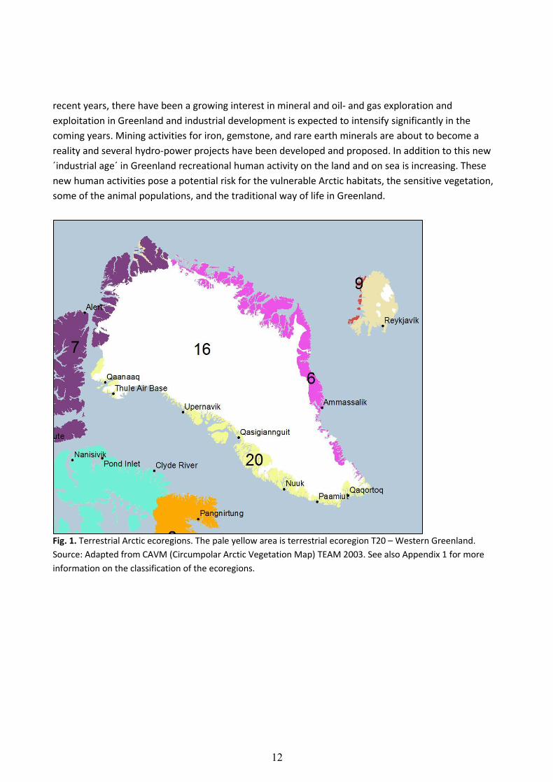
tip of Greenland in the south at Kap Farvel (60° N) to the top of Greenland in the far north (78° N) (Fig.
1; Appendix 1). The largest ice-free land areas in the ecoregion are found between 65-68°N. The coast
line is characterized by deep fjords, high mountains and a countless number of islands and skerries.
The ecoregion spans three climatic zones: subarctic, low Arctic, and high Arctic, and large differences
in climate, soil conditions, and ecosystems are found within the region. Greenland is intersected by the
Arctic Circle (66° 33′ 39″ N), where areas north of the circle have midnight sun for a period in summer
and polar darkness in winter. Thus the region experiences considerable variation in day length and
light conditions (Jensen 2003).
Generally, primary productivity on land in Greenland is low, limited by low summer
temperatures and a short growing season. However, because of large differences in climate and
topography/landscape heterogeneity throughout the region, the magnitude of net primary
productivity and distribution of vegetation varies greatly across the ecoregion as well as locally. Most
land areas have only relatively recently been exposed following ice sheet retreat and pioneer species
with low nutrient requirements typically dominate in these areas. In the mid-southern parts of the
Western Greenland ecoregion, where the ice cap is smaller and areas have been ice-free for millennia,
the diversity of plants is higher (Jensen 2003). The ecoregion is home to a variety of fish, birds, and
mammals. Among the anadromous freshwater fish found in rivers and lakes are Atlantic salmon (Salmo
salar) and Arctic char (Salvelinus alpines) (Appendix 2). Birds of prey includes peregrine falcon (Falco
peregrinus), gyrfalcon (Falco rusticolus), and white-tailed eagle (Haliaeetus albicilla). The rock
ptarmigan (Lagopus mutus) and raven (Corvus corax) are found throughout the year in the region,
while the arrival of the small snow bunting (Plectrophenax nivalis) announces the coming of spring.
Indigenous land mammals include caribou (Rangifer tarandus spp.), Arctic hare (Lepus arcticus), Arctic
fox (Alopex lagopus), Arctic wolf (Canis lupus arctos), and polar bear (Ursus Maritimus) that have
denning areas in the far north. Muskoxen (Ovibos moschatus) were introduced from East Greenland in
the 1960’s and have thrived at various places in West Greenland ever since. Semi-domestic reindeer
were introduced in the last century and through releases or failure of husbandry feral populations now
exist in the Qaanaaq area, at the Nuussuaq peninsula and in the Nuuk areas, where they coexist or mix
with indigenous caribou (Appendix 2). Reindeer husbandry continues today in the most southern part
of the ecoregion.
Humans have inhabited Greenland for millennia, where they have lived off the land and sea.
Today, the Inuit population in Greenland is mainly concentrated along the West Greenland coast with
a few settlements sparsely located in the North and on the East coast. In Northeast Greenland the
world's largest national park is found1. It was established in 1974 and covers an area of 972.000 km². In
1 The area is a National Park according to Greenland's own definition but does not meet the IUCN international criteria
for National Parks because of, among other things, mining activities in the area. The area is also designated as a
UNESCO Biosphere Reserve. http://naalakkersuisut.gl/da/Naalakkersuisut/Departementer/Natur-og-
Miljoe/Naturafdelingen/Nationalparken-i-Nord-og-Oestgroenland.
12
recent years, there have been a growing interest in mineral and oil- and gas exploration and
exploitation in Greenland and industrial development is expected to intensify significantly in the
coming years. Mining activities for iron, gemstone, and rare earth minerals are about to become a
reality and several hydro-power projects have been developed and proposed. In addition to this new
´industrial age´ in Greenland recreational human activity on the land and on sea is increasing. These
new human activities pose a potential risk for the vulnerable Arctic habitats, the sensitive vegetation,
some of the animal populations, and the traditional way of life in Greenland.
Fig. 1. Terrestrial Arctic ecoregions. The pale yellow area is terrestrial ecoregion T20 – Western Greenland.
Source: Adapted from CAVM (Circumpolar Arctic Vegetation Map) TEAM 2003. See also Appendix 1 for more
information on the classification of the ecoregions.
13
KEY FEATURES IMPORTANT FOR RESILIENCE
The present RACER report of the Western Greenland ecoregion involves analysis of satellite remote
sensing data (Box 1), relevant scientific literature and reports, and expert evaluation. The data used
reflects landscape heterogeneity, biodiversity, and the location of local communities (reflecting
traditional land-use and use of natural resources). Ten terrestrial key features have been identified.
The ten key features were designated by WWF together with experts into Arctic biology.
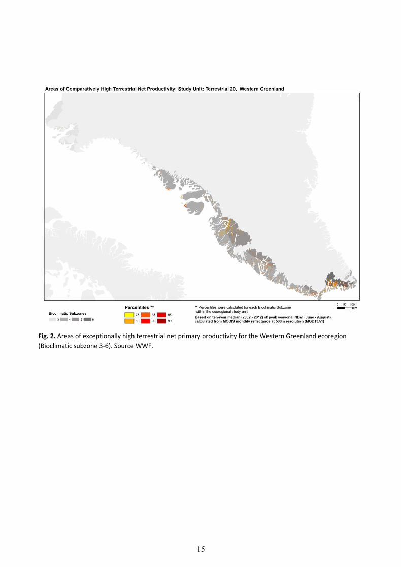
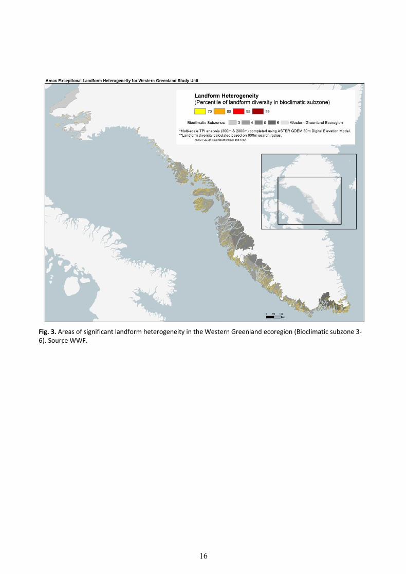
Distinguished by their medium or high levels of productivity (Fig. 2), their varied topography/
landscape heterogeneity (Fig. 3), and/or high biodiversity, the ten key features represent sites of
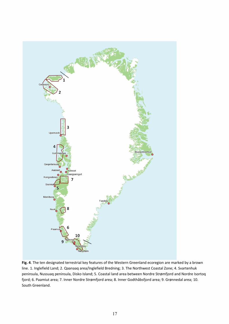
potentially conservation importance. The key feature map (Fig. 4) is intended to inform discussions
about the best management approaches to safeguard the productivity and diversity of these unique
places.
Within the RACER method lays an evaluation of the likelihood that key features will continue to
contribute to region-wide resilience when 21st century climate change affects the drivers at work in
ecologically vital places. Drivers include those susceptible to the impacts of climate change, such as
temperature, precipitation, soil moisture, as well as those impervious to climate effects (on a
centennial time scale/for the next 100 years), such as topography and soil type. RACER uses forecasts
from current General Circulation Models (GCMs) to predict climate-related changes to ecologically
significant variables within ecoregions for the remainder of this century (Appendix 3). However, this
evaluation is not included in the report. It was concluded by the experts at a RACER workshop in
January 2014 that it was not feasible to obtain reliable assessments of the persistence of key features
and their future above-average productivity/diversity based on the available data and the current
knowledge of the terrestrial ecosystems in Greenland (see section RACER Expert Workshop, p. 19).
14
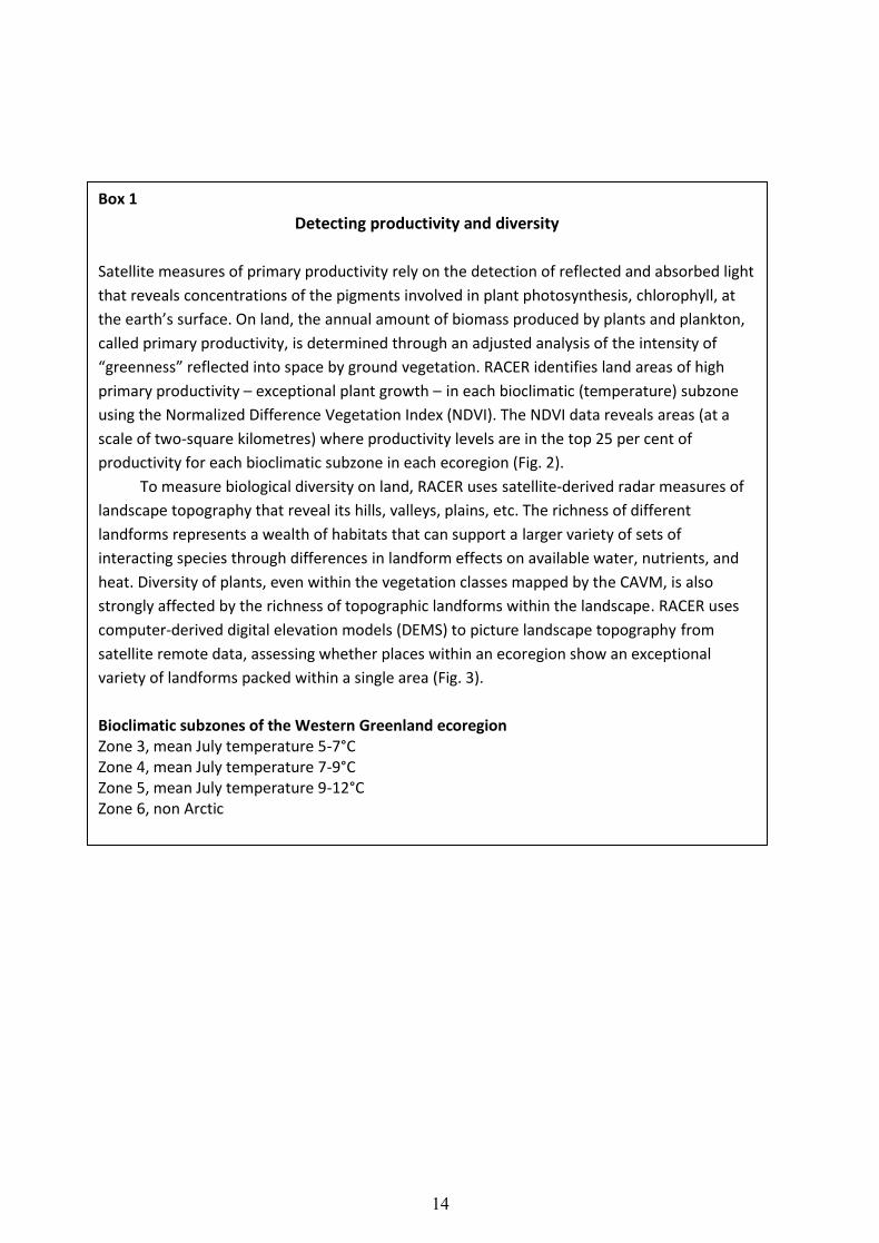
Box 1
Detecting productivity and diversity
Satellite measures of primary productivity rely on the detection of reflected and absorbed light
that reveals concentrations of the pigments involved in plant photosynthesis, chlorophyll, at
the earth’s surface. On land, the annual amount of biomass produced by plants and plankton,
called primary productivity, is determined through an adjusted analysis of the intensity of
“greenness” reflected into space by ground vegetation. RACER identifies land areas of high
primary productivity – exceptional plant growth – in each bioclimatic (temperature) subzone
using the Normalized Difference Vegetation Index (NDVI). The NDVI data reveals areas (at a
scale of two-square kilometres) where productivity levels are in the top 25 per cent of
productivity for each bioclimatic subzone in each ecoregion (Fig. 2).
To measure biological diversity on land, RACER uses satellite-derived radar measures of
landscape topography that reveal its hills, valleys, plains, etc. The richness of different
landforms represents a wealth of habitats that can support a larger variety of sets of
interacting species through differences in landform effects on available water, nutrients, and
heat. Diversity of plants, even within the vegetation classes mapped by the CAVM, is also
strongly affected by the richness of topographic landforms within the landscape. RACER uses
computer-derived digital elevation models (DEMS) to picture landscape topography from
satellite remote data, assessing whether places within an ecoregion show an exceptional
variety of landforms packed within a single area (Fig. 3).
Bioclimatic subzones of the Western Greenland ecoregion Zone 3, mean July temperature 5-7°C Zone 4, mean July temperature 7-9°C Zone 5, mean July temperature 9-12°C Zone 6, non Arctic
15
Fig. 2. Areas of exceptionally high terrestrial net primary productivity for the Western Greenland ecoregion
(Bioclimatic subzone 3-6). Source WWF.
16
Fig. 3. Areas of significant landform heterogeneity in the Western Greenland ecoregion (Bioclimatic subzone 3- 6). Source WWF.
17
Fig. 4. The ten designated terrestrial key features of the Western Greenland ecoregion are marked by a brown
line. 1. Inglefield Land; 2. Qaanaaq area/Inglefield Bredning; 3. The Northwest Coastal Zone; 4. Svartenhuk
peninsula, Nussuaq peninsula, Disko Island; 5. Coastal land area between Nordre Strømfjord and Nordre Isortoq
fjord; 6. Paamiut area; 7. Inner Nordre Strømfjord area; 8. Inner Godthåbsfjord area; 9. Grønnedal area; 10.
South Greenland.
18
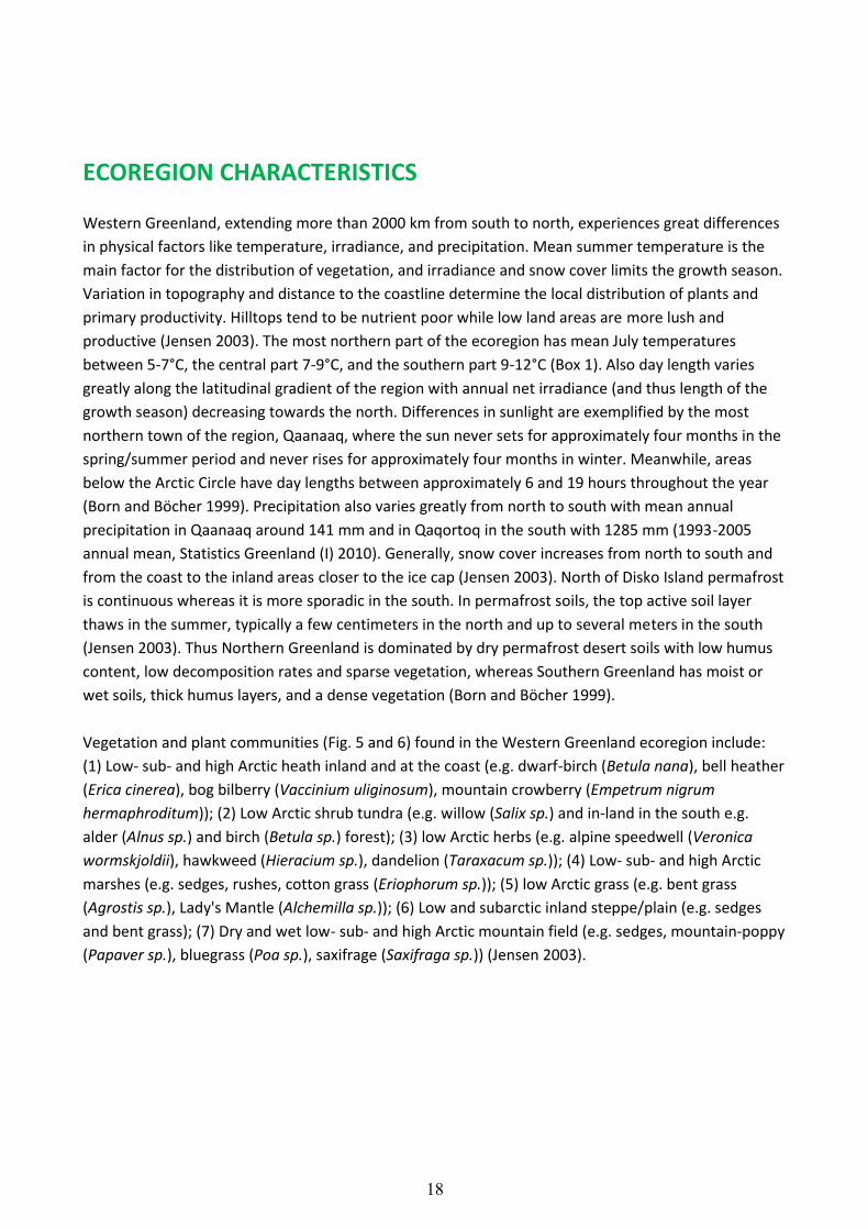
ECOREGION CHARACTERISTICS
Western Greenland, extending more than 2000 km from south to north, experiences great differences
in physical factors like temperature, irradiance, and precipitation. Mean summer temperature is the
main factor for the distribution of vegetation, and irradiance and snow cover limits the growth season.
Variation in topography and distance to the coastline determine the local distribution of plants and
primary productivity. Hilltops tend to be nutrient poor while low land areas are more lush and
productive (Jensen 2003). The most northern part of the ecoregion has mean July temperatures
between 5-7°C, the central part 7-9°C, and the southern part 9-12°C (Box 1). Also day length varies
greatly along the latitudinal gradient of the region with annual net irradiance (and thus length of the
growth season) decreasing towards the north. Differences in sunlight are exemplified by the most
northern town of the region, Qaanaaq, where the sun never sets for approximately four months in the
spring/summer period and never rises for approximately four months in winter. Meanwhile, areas
below the Arctic Circle have day lengths between approximately 6 and 19 hours throughout the year
(Born and Böcher 1999). Precipitation also varies greatly from north to south with mean annual
precipitation in Qaanaaq around 141 mm and in Qaqortoq in the south with 1285 mm (1993-2005
annual mean, Statistics Greenland (I) 2010). Generally, snow cover increases from north to south and
from the coast to the inland areas closer to the ice cap (Jensen 2003). North of Disko Island permafrost
is continuous whereas it is more sporadic in the south. In permafrost soils, the top active soil layer
thaws in the summer, typically a few centimeters in the north and up to several meters in the south
(Jensen 2003). Thus Northern Greenland is dominated by dry permafrost desert soils with low humus
content, low decomposition rates and sparse vegetation, whereas Southern Greenland has moist or
wet soils, thick humus layers, and a dense vegetation (Born and Böcher 1999).
Vegetation and plant communities (Fig. 5 and 6) found in the Western Greenland ecoregion include:
(1) Low- sub- and high Arctic heath inland and at the coast (e.g. dwarf-birch (Betula nana), bell heather
(Erica cinerea), bog bilberry (Vaccinium uliginosum), mountain crowberry (Empetrum nigrum
hermaphroditum)); (2) Low Arctic shrub tundra (e.g. willow (Salix sp.) and in-land in the south e.g.
alder (Alnus sp.) and birch (Betula sp.) forest); (3) low Arctic herbs (e.g. alpine speedwell (Veronica
wormskjoldii), hawkweed (Hieracium sp.), dandelion (Taraxacum sp.)); (4) Low- sub- and high Arctic
marshes (e.g. sedges, rushes, cotton grass (Eriophorum sp.)); (5) low Arctic grass (e.g. bent grass
(Agrostis sp.), Lady's Mantle (Alchemilla sp.)); (6) Low and subarctic inland steppe/plain (e.g. sedges
and bent grass); (7) Dry and wet low- sub- and high Arctic mountain field (e.g. sedges, mountain-poppy
(Papaver sp.), bluegrass (Poa sp.), saxifrage (Saxifraga sp.)) (Jensen 2003).
1
19
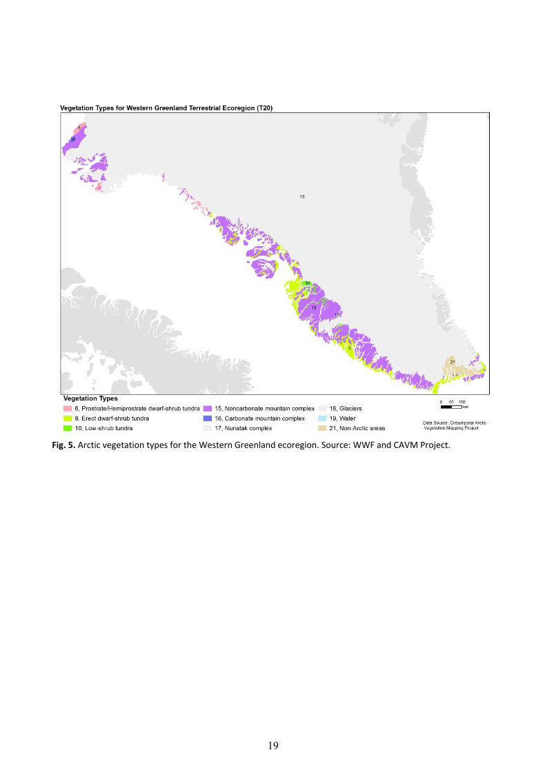
Fig. 5. Arctic vegetation types for the Western Greenland ecoregion. Source: WWF and CAVM Project.

20
Fig. 6. Vegetation at the Western Greenland ecoregion (locations Nuuk and Ilullissat). Photos Eva Garde, WWF. A) Mountain crowberry / Fjeld-revling
B) Dwarf birch / Dværg-birk
C) Gray willow / Blågrå pil (Salix glauca)
D) Lapland rosebay / Arktisk alperose (Rhododendron lapponicum)
E) Blue mountain heath / Blålyng (Phyllodoce caerulea)
F) Alpine azalea / Kryblyng (Loiseleuria procumbens)
21
RACER EXPERT WORKSHOP, JANUARY 2014
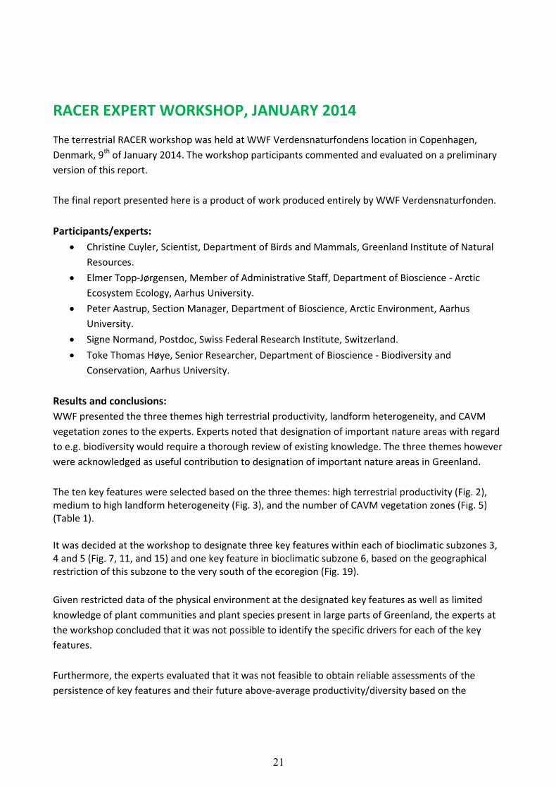
The terrestrial RACER workshop was held at WWF Verdensnaturfondens location in Copenhagen,
Denmark, 9th of January 2014. The workshop participants commented and evaluated on a preliminary
version of this report.
The final report presented here is a product of work produced entirely by WWF Verdensnaturfonden.
Participants/experts:
Christine Cuyler, Scientist, Department of Birds and Mammals, Greenland Institute of Natural
Resources.
Elmer Topp-Jørgensen, Member of Administrative Staff, Department of Bioscience - Arctic
Ecosystem Ecology, Aarhus University.
Peter Aastrup, Section Manager, Department of Bioscience, Arctic Environment, Aarhus
University.
Signe Normand, Postdoc, Swiss Federal Research Institute, Switzerland.
Toke Thomas Høye, Senior Researcher, Department of Bioscience - Biodiversity and
Conservation, Aarhus University.
Results and conclusions:
WWF presented the three themes high terrestrial productivity, landform heterogeneity, and CAVM
vegetation zones to the experts. Experts noted that designation of important nature areas with regard
to e.g. biodiversity would require a thorough review of existing knowledge. The three themes however
were acknowledged as useful contribution to designation of important nature areas in Greenland.
The ten key features were selected based on the three themes: high terrestrial productivity (Fig. 2), medium to high landform heterogeneity (Fig. 3), and the number of CAVM vegetation zones (Fig. 5) (Table 1).
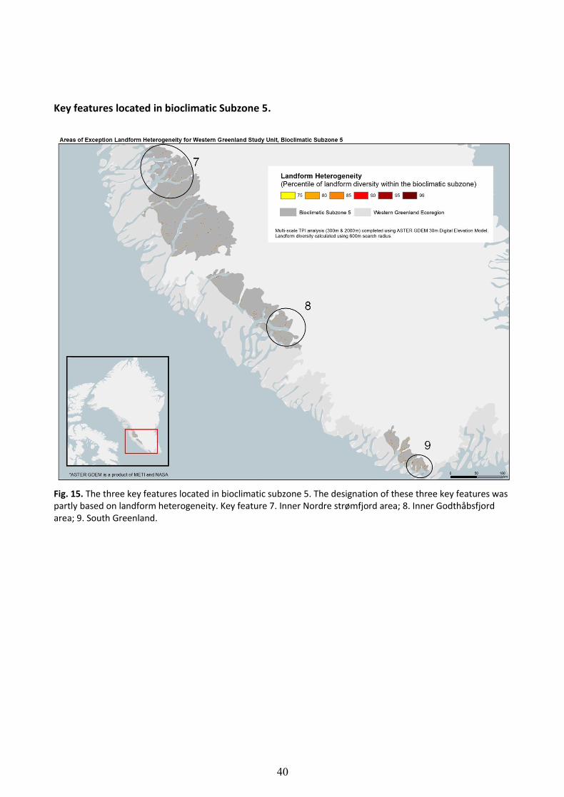
It was decided at the workshop to designate three key features within each of bioclimatic subzones 3, 4 and 5 (Fig. 7, 11, and 15) and one key feature in bioclimatic subzone 6, based on the geographical restriction of this subzone to the very south of the ecoregion (Fig. 19).
Given restricted data of the physical environment at the designated key features as well as limited
knowledge of plant communities and plant species present in large parts of Greenland, the experts at
the workshop concluded that it was not possible to identify the specific drivers for each of the key
features.
Furthermore, the experts evaluated that it was not feasible to obtain reliable assessments of the
persistence of key features and their future above-average productivity/diversity based on the
22
available data and the current knowledge of the terrestrial ecosystems in Greenland. Main conclusions
of the workshop were:
It was pointed out by the experts that the given climate models, covering a huge latitudinal gradient from 60-78°N, were too general to be useful for the Western Greenland ecoregion, (Ap. 3). The resolution in the models was too low to make precise predictions and assessments of ecosystem resilience. There is a need for regional climate models, with sufficient resolution for the ecoregions.
It was noted that the CAVM vegetation map (Fig. 5) does not reflect the regional gradient from
the coast to the inland at the Greenland Ice Cap.
It was further noted that the net primary productivity map (Fig. 2) is partly incorrect in showing
high terrestrial productivity. For instance, in the Godthåbsfjord area two large lakes have been
given the same colour on the map as the colour of high terrestrial productivity. This is
confusing for interpretation of the map.
Given the size of the Western Greenland ecoregion the experts felt that the maps of net
primary productivity and landform heterogeneity were to coarse, and that unique small areas
were lost using such a large scale.
Experts suggested the possibility of placing GIS files from the net primary productivity analysis and files
from the landform heterogeneity analysis ‘on top of each other’ to let the computer point out places
of combined high terrestrial productivity and significant heterogeneity to be designated as key
features.
It was emphasized that a further specified choice of key features and their borders than presently
reported will require additional studies to provide a better data foundation for pointing out designated
areas.
Experts noted that the RACER concept of resilience is important and useful even though challenging to
apply.
The RACER method for terrestrial areas works within a context of identifying and designating areas of
high net primary productivity and landform heterogeneity today and in the future. These areas are
important to take into account in regional nature management, but the method is not suitable to
ensure the protection of the High Arctic species that are most threatened by climate change. However,
by selecting at least one key feature within each bioclimatic subzone, this can somewhat be accounted
for.

23
KEY FEATURES TERRESTRIAL PRODUCTIVITY
LANDFORM HETEROGENEITY
CAVM VEGETATION
ZONES
1. Inglefield Land - - 3*
2. Qaanaaq area/Inglefield Bredning
- Medium – High 1
3. The Northwest Coastal Zone - High 3
4. Svartenhuk peninsula, Nussuaq peninsula, Disko Island
High Medium – High 2-3
5. Coastal land area between Nordre Strømfjord and Nordre Isortoq fjord
High High 3
6. Paamiut area High High 2
7. Inner Nordre Strømfjord area High High 3
8. Inner Godthåbsfjord area High Medium 1
9. Grønnedal area High High 3
10. South Greenland High Medium 2**
*One vegetation zone (#16) found at Inglefield Land is unique to the Western Greenland ecoregion. **Part of this area has been defined as non-Arctic (Fig. 5).
Table 1. Three key features were designated in each bioclimatic subzone (3-5) along the Western Greenland
ecoregion. One key feature was designated in bioclimatic subzone 6 as this subzone is geographically restricted
to the very south of the ecoregion. The ten key features presented in this table were designated based on three
criteria: high terrestrial productivity (Fig. 2), medium to high landform heterogeneity (Fig. 3), and number of
CAVM vegetation zones (Fig. 5). A more detailed description of each key feature is found in the text.
24
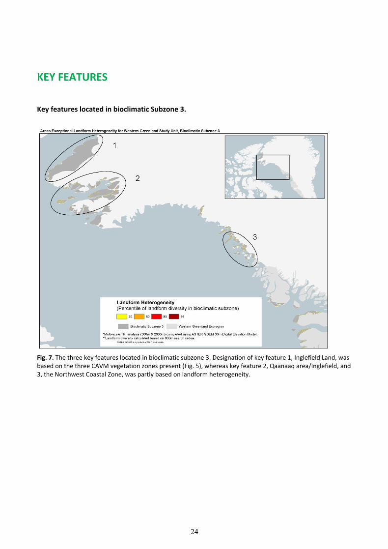
KEY FEATURES
Key features located in bioclimatic Subzone 3.
Fig. 7. The three key features located in bioclimatic subzone 3. Designation of key feature 1, Inglefield Land, was based on the three CAVM vegetation zones present (Fig. 5), whereas key feature 2, Qaanaaq area/Inglefield, and 3, the Northwest Coastal Zone, was partly based on landform heterogeneity.

25
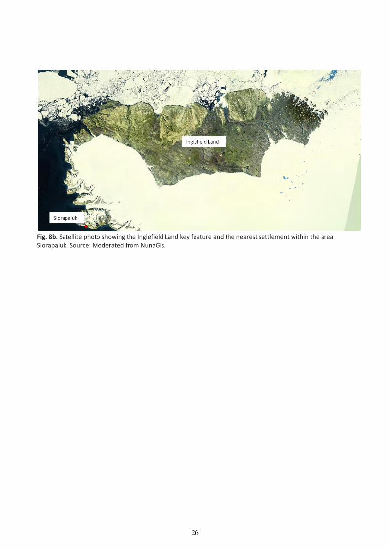
1. INGLEFIELD LAND
The designation of key feature 1, Inglefield Land, was based on three CAVM vegetation zones (zone 6,
15 and 16; Fig. 5), where vegetation zone 16 is unique within the Western Greenland ecoregion. All of
Inglefield Land has been designated as a key feature as there was no basis within the RACER method
for identifying a subset of this area.
Inglefield Land is located at 78°N on the northwest coast of Greenland (Fig. 8a and b), next to Smith
Sound, Nares Strait and Kane Basin and east of the North Water polynya. This high Arctic area is a
rectangular ice-free land strip nearly 200 kilometres long, 50 kilometres wide at the widest point, and
approximately 6,500 km2 (Landa et al. 2000a, Jensen 1999). The landscape is diverse consisting of
mountains and valleys as well as large plains. Four terrestrial mammals live here; caribou, musk ox,
Arctic hare, and Arctic fox, and the area is also known as a place for polar bear maternity denning
(Jensen 1999). The estimated population number of the caribou was in 1999 at 2300 individuals (Landa
et al. 2000b) however current status of the population is unknown. Nearest human settlement is
Siorapaluk that currently holds 57 inhabitants (Grønlands Statistik, January 2014) and the nearest town
is Qaanaaq with a population of 656.
Fig. 8a. Key feature 1, Inglefield Land, is shown by the green line. The defined borders of key features are only
indicative.
26
Fig. 8b. Satellite photo showing the Inglefield Land key feature and the nearest settlement within the area Siorapaluk. Source: Moderated from NunaGis.
27
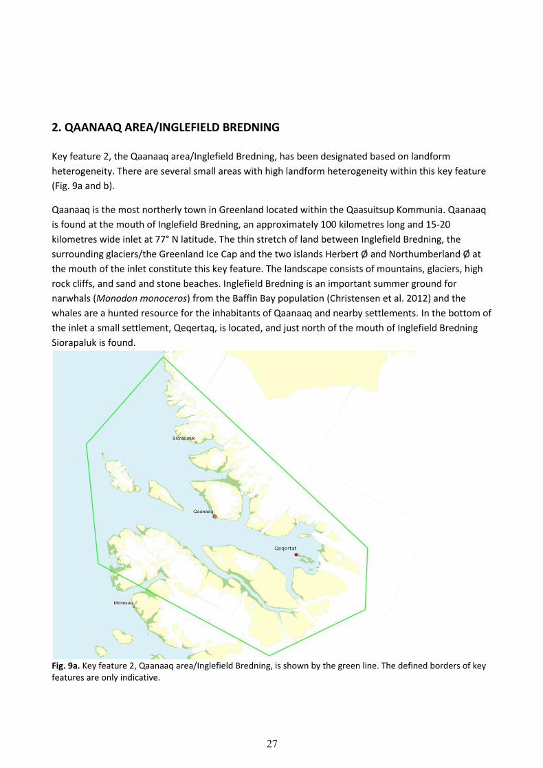
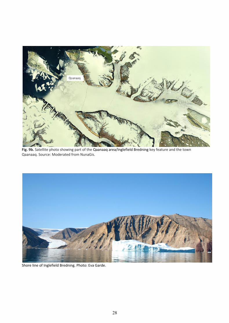
2. QAANAAQ AREA/INGLEFIELD BREDNING
Key feature 2, the Qaanaaq area/Inglefield Bredning, has been designated based on landform
heterogeneity. There are several small areas with high landform heterogeneity within this key feature
(Fig. 9a and b).
Qaanaaq is the most northerly town in Greenland located within the Qaasuitsup Kommunia. Qaanaaq
is found at the mouth of Inglefield Bredning, an approximately 100 kilometres long and 15-20
kilometres wide inlet at 77° N latitude. The thin stretch of land between Inglefield Bredning, the
surrounding glaciers/the Greenland Ice Cap and the two islands Herbert Ø and Northumberland Ø at
the mouth of the inlet constitute this key feature. The landscape consists of mountains, glaciers, high
rock cliffs, and sand and stone beaches. Inglefield Bredning is an important summer ground for
narwhals (Monodon monoceros) from the Baffin Bay population (Christensen et al. 2012) and the
whales are a hunted resource for the inhabitants of Qaanaaq and nearby settlements. In the bottom of
the inlet a small settlement, Qeqertaq, is located, and just north of the mouth of Inglefield Bredning
Siorapaluk is found.
Fig. 9a. Key feature 2, Qaanaaq area/Inglefield Bredning, is shown by the green line. The defined borders of key features are only indicative.
28
Fig. 9b. Satellite photo showing part of the Qaanaaq area/Inglefield Bredning key feature and the town Qaanaaq. Source: Moderated from NunaGis.
Shore line of Inglefield Bredning. Photo: Eva Garde.
29
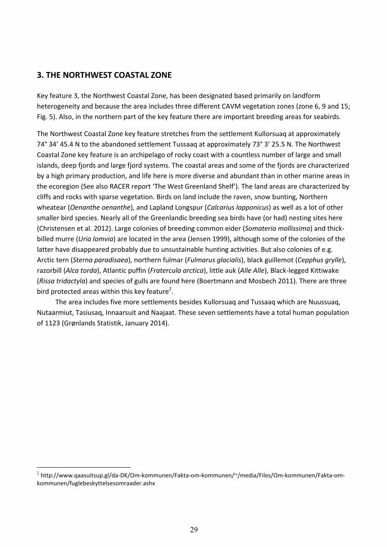
3. THE NORTHWEST COASTAL ZONE
Key feature 3, the Northwest Coastal Zone, has been designated based primarily on landform
heterogeneity and because the area includes three different CAVM vegetation zones (zone 6, 9 and 15;
Fig. 5). Also, in the northern part of the key feature there are important breeding areas for seabirds.
The Northwest Coastal Zone key feature stretches from the settlement Kullorsuaq at approximately
74° 34’ 45.4 N to the abandoned settlement Tussaaq at approximately 73° 3’ 25.5 N. The Northwest
Coastal Zone key feature is an archipelago of rocky coast with a countless number of large and small
islands, deep fjords and large fjord systems. The coastal areas and some of the fjords are characterized
by a high primary production, and life here is more diverse and abundant than in other marine areas in
the ecoregion (See also RACER report ‘The West Greenland Shelf’). The land areas are characterized by
cliffs and rocks with sparse vegetation. Birds on land include the raven, snow bunting, Northern
wheatear (Oenanthe oenanthe), and Lapland Longspur (Calcarius lapponicus) as well as a lot of other
smaller bird species. Nearly all of the Greenlandic breeding sea birds have (or had) nesting sites here
(Christensen et al. 2012). Large colonies of breeding common eider (Somateria mollissima) and thick-
billed murre (Uria lomvia) are located in the area (Jensen 1999), although some of the colonies of the
latter have disappeared probably due to unsustainable hunting activities. But also colonies of e.g.
Arctic tern (Sterna paradisaea), northern fulmar (Fulmarus glacialis), black guillemot (Cepphus grylle),
razorbill (Alca torda), Atlantic puffin (Fratercula arctica), little auk (Alle Alle), Black-legged Kittiwake
(Rissa tridactyla) and species of gulls are found here (Boertmann and Mosbech 2011). There are three
bird protected areas within this key feature2. The area includes five more settlements besides Kullorsuaq and Tussaaq which are Nuussuaq,
Nutaarmiut, Tasiusaq, Innaarsuit and Naajaat. These seven settlements have a total human population
of 1123 (Grønlands Statistik, January 2014).
2 http://www.qaasuitsup.gl/da-DK/Om-kommunen/Fakta-om-kommunen/~/media/Files/Om-kommunen/Fakta-om-
kommunen/fuglebeskyttelsesomraader.ashx

30
Fig. 10a. Key feature 3, the Northwest Coastal Zone, is shown by the green line. The defined borders of key features are only indicative.
31
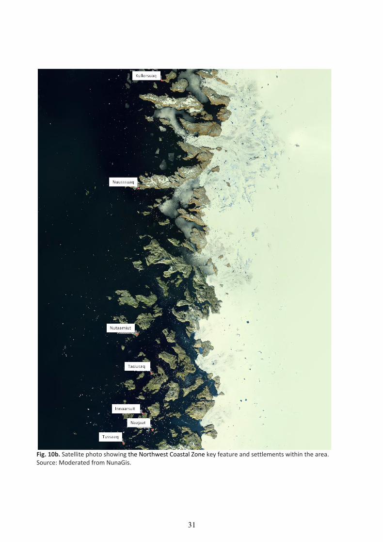
Fig. 10b. Satellite photo showing the Northwest Coastal Zone key feature and settlements within the area. Source: Moderated from NunaGis.

32
Key features located in bioclimatic Subzone 4.
Fig. 11. The three key features located within bioclimatic subzone 4. The designation of these three key features was partly based on landform heterogeneity. Key features: 4. Parts of Svartenhuk peninsula, Nuussuaq peninsula and Disko Island; 5. Coastal land area between Nordre Strømfjord and the Nordre Isortoq fjord; 6. The Paamiut area.
33
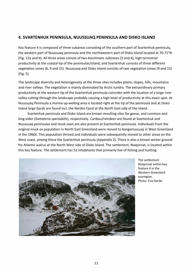
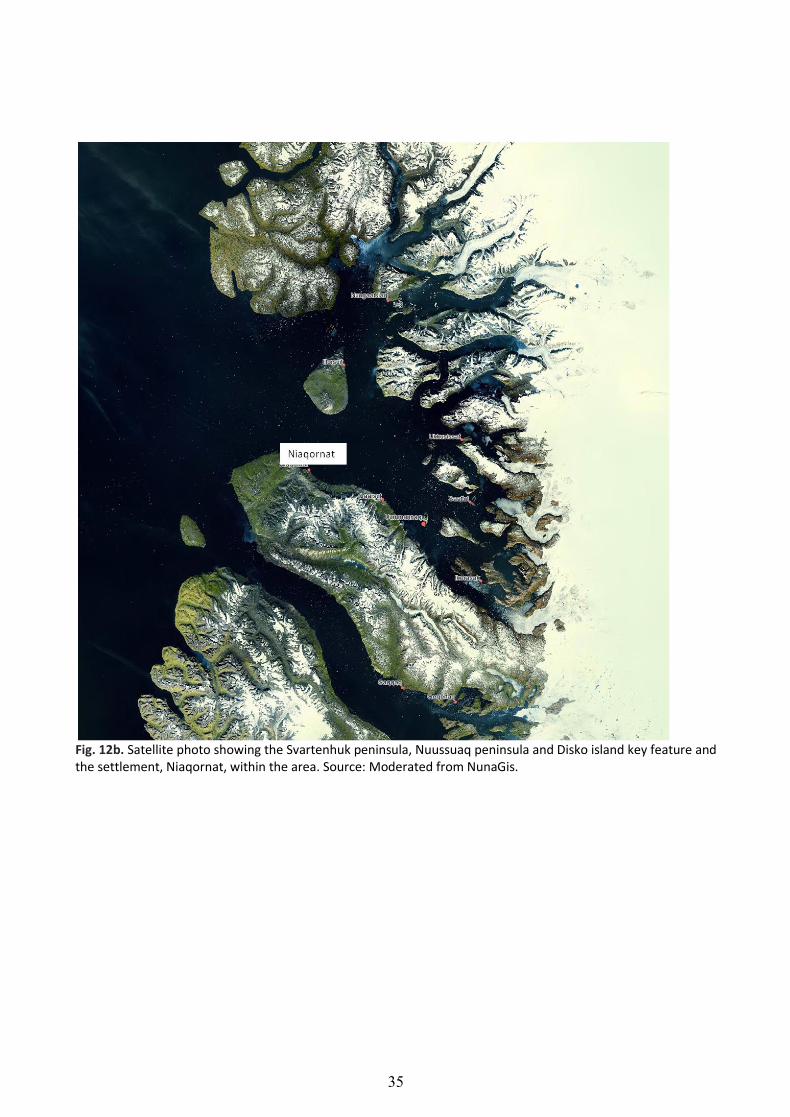
4. SVARTENHUK PENINSULA, NUUSSUAQ PENINSULA AND DISKO ISLAND
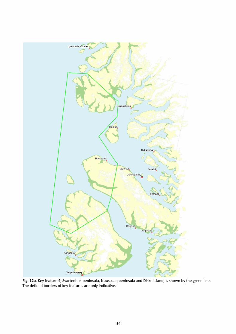
Key feature 4 is composed of three subareas consisting of the southern part of Svartenhuk peninsula,
the western part of Nuussuaq peninsula and the northwestern part of Disko Island located at 70-71°N
(Fig. 12a and b). All three areas consist of two bioclimatic subzones (3 and 4), high terrestrial
productivity at the coastal tip of the peninsulas/Island, and Svartenhuk consists of three different
vegetation zones (6, 9 and 15). Nuussuaq and Disko Island consists of two vegetation zones (9 and 15)
(Fig. 5).
The landscape diversity and heterogeneity at the three sites includes plains, slopes, hills, mountains
and river valleys. The vegetation is mainly dominated by Arctic tundra. The extraordinary primary
productivity at the western tip of the Svartenhuk peninsula coincides with the location of a large river
valley cutting through the landscape probably causing a high level of productivity at this exact spot. At
Nuussuaq Peninsula a marine up-welling area is located right at the tip of the peninsula and at Disko
Island large fjords are found incl. the Nordre Fjord at the North East side of the Island.
Svartenhuk peninsula and Disko Island are known moulting sites for geese, and common and
king eider (Somateria spectabilis), respectively. Caribou/reindeer are found at Svartenhuk and
Nuussuaq peninsulas and musk oxen are also present at Svartenhuk peninsula. Individuals from the
original musk ox population in North East Greenland were moved to Kangerlussuaq in West Greenland
in the 1960s. This population thrived and individuals were subsequently moved to other areas on the
West coast, among these the Svartenhuk peninsula (Appendix 2). There is also a known winter ground
for Atlantic walrus at the North West side of Disko Island. The settlement, Niaqornat, is located within
this key feature. The settlement has 52 inhabitants that primarily live of fishing and hunting.
The settlement Niaqornat within key feature 4 in the Western Greenland ecoregion. Photo: Eva Garde.
34
Fig. 12a. Key feature 4, Svartenhuk peninsula, Nuussuaq peninsula and Disko Island, is shown by the green line. The defined borders of key features are only indicative.
35
Fig. 12b. Satellite photo showing the Svartenhuk peninsula, Nuussuaq peninsula and Disko island key feature and the settlement, Niaqornat, within the area. Source: Moderated from NunaGis.

36
5. LAND AREA BETWEEN NORDRE STRØMFJORD AND NORDRE ISORTOQ FJORD
Key feature 5, the coastal land area between the Nordre Strømfjord and the Nordre Isortoq fjord, has
been designated based on a combination of high landform heterogeneity and high terrestrial
productivity. Also, the area include three different vegetation zones (9, 10 and 15; Fig. 5).
This coastal land area is located between the Nordre Strømfjord at approximately 67° 28’ 23.5 N and
the Nordre Isortoq fjord at 67° 10’ 45.1 N, north of the town Sisimiut (Fig. 13a and b). The fjord
systems uphold a rich bird life in summer. The Naternaq caribou population belongs to this area, which
is one out of 12 caribou populations in Greenland.
Fig. 13a. Key feature 5, the coastal land area between Nordre Strømfjord and Nordre Isortoq fjord, is shown by the green line. The defined borders of key features are only indicative.

37
Fig. 13b. Satellite photo showing key feature 5, the coastal land area between Nordre Strømfjord and Nordre Isortoq fjord, and the town, Sisimiut, to the south. Source: Moderated from NunaGis.
38
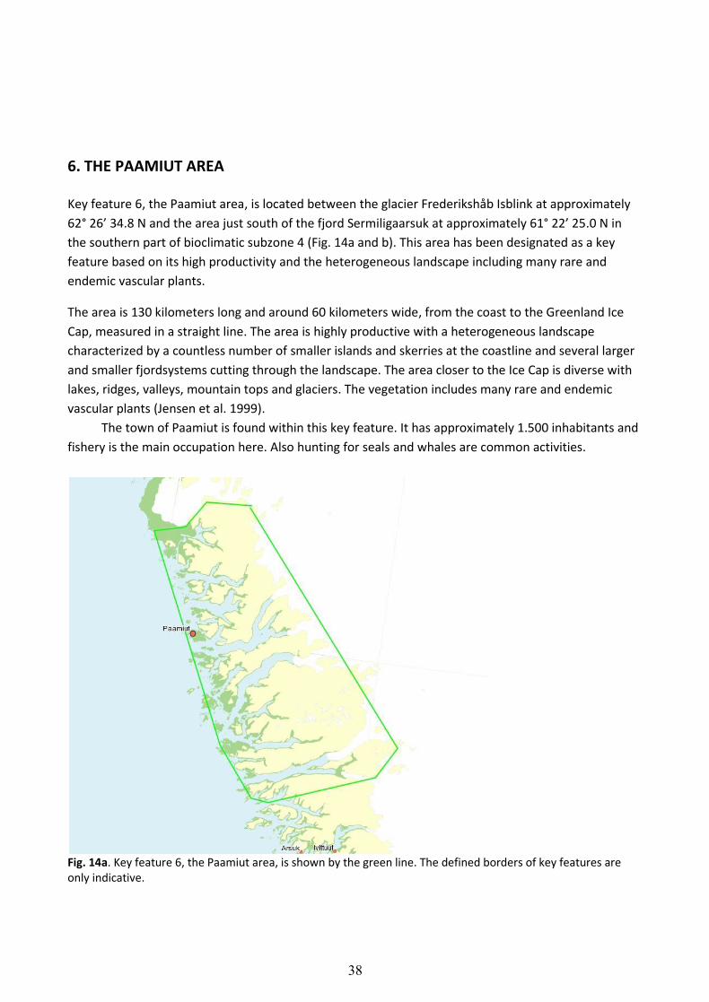
6. THE PAAMIUT AREA
Key feature 6, the Paamiut area, is located between the glacier Frederikshåb Isblink at approximately
62° 26’ 34.8 N and the area just south of the fjord Sermiligaarsuk at approximately 61° 22’ 25.0 N in
the southern part of bioclimatic subzone 4 (Fig. 14a and b). This area has been designated as a key
feature based on its high productivity and the heterogeneous landscape including many rare and
endemic vascular plants.
The area is 130 kilometers long and around 60 kilometers wide, from the coast to the Greenland Ice
Cap, measured in a straight line. The area is highly productive with a heterogeneous landscape
characterized by a countless number of smaller islands and skerries at the coastline and several larger
and smaller fjordsystems cutting through the landscape. The area closer to the Ice Cap is diverse with
lakes, ridges, valleys, mountain tops and glaciers. The vegetation includes many rare and endemic
vascular plants (Jensen et al. 1999).
The town of Paamiut is found within this key feature. It has approximately 1.500 inhabitants and
fishery is the main occupation here. Also hunting for seals and whales are common activities.
Fig. 14a. Key feature 6, the Paamiut area, is shown by the green line. The defined borders of key features are only indicative.
39
Fig. 14b. Satellite photo showing key feature 6, the Paamiut area, between Frederikshåb Isblink and Sermiligaarsuk, and the town of Paamiut. Source: Moderated from NunaGis.
40
Key features located in bioclimatic Subzone 5.
Fig. 15. The three key features located in bioclimatic subzone 5. The designation of these three key features was partly based on landform heterogeneity. Key feature 7. Inner Nordre strømfjord area; 8. Inner Godthåbsfjord area; 9. South Greenland.
41
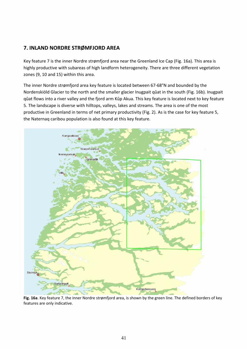
7. INLAND NORDRE STRØMFJORD AREA
Key feature 7 is the inner Nordre strømfjord area near the Greenland Ice Cap (Fig. 16a). This area is
highly productive with subareas of high landform heterogeneity. There are three different vegetation
zones (9, 10 and 15) within this area.
The inner Nordre strømfjord area key feature is located between 67-68°N and bounded by the
Nordenskiöld Glacier to the north and the smaller glacier Inugpait qûat in the south (Fig. 16b). Inugpait
qûat flows into a river valley and the fjord arm Kûp Akua. This key feature is located next to key feature
5. The landscape is diverse with hilltops, valleys, lakes and streams. The area is one of the most
productive in Greenland in terms of net primary productivity (Fig. 2). As is the case for key feature 5,
the Naternaq caribou population is also found at this key feature.
Fig. 16a. Key feature 7, the inner Nordre strømfjord area, is shown by the green line. The defined borders of key features are only indicative.
42
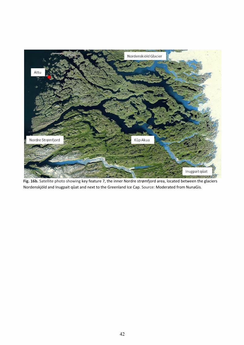
Fig. 16b. Satellite photo showing key feature 7, the inner Nordre strømfjord area, located between the glaciers
Nordenskjöld and Inugpait qûat and next to the Greenland Ice Cap. Source: Moderated from NunaGis.
43
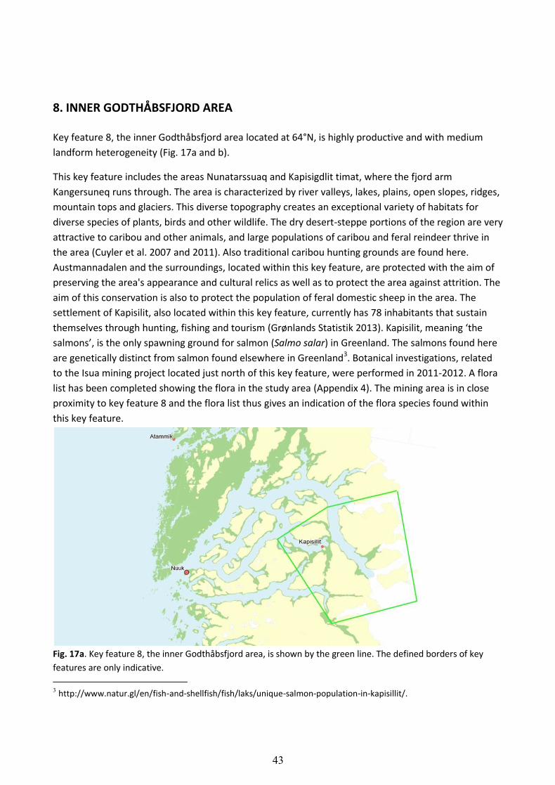
8. INNER GODTHÅBSFJORD AREA
Key feature 8, the inner Godthåbsfjord area located at 64°N, is highly productive and with medium
landform heterogeneity (Fig. 17a and b).
This key feature includes the areas Nunatarssuaq and Kapisigdlit timat, where the fjord arm
Kangersuneq runs through. The area is characterized by river valleys, lakes, plains, open slopes, ridges,
mountain tops and glaciers. This diverse topography creates an exceptional variety of habitats for
diverse species of plants, birds and other wildlife. The dry desert-steppe portions of the region are very
attractive to caribou and other animals, and large populations of caribou and feral reindeer thrive in
the area (Cuyler et al. 2007 and 2011). Also traditional caribou hunting grounds are found here.
Austmannadalen and the surroundings, located within this key feature, are protected with the aim of
preserving the area's appearance and cultural relics as well as to protect the area against attrition. The
aim of this conservation is also to protect the population of feral domestic sheep in the area. The
settlement of Kapisilit, also located within this key feature, currently has 78 inhabitants that sustain
themselves through hunting, fishing and tourism (Grønlands Statistik 2013). Kapisilit, meaning ‘the
salmons’, is the only spawning ground for salmon (Salmo salar) in Greenland. The salmons found here
are genetically distinct from salmon found elsewhere in Greenland3. Botanical investigations, related
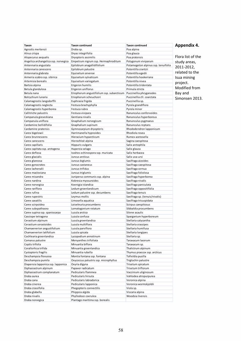
to the Isua mining project located just north of this key feature, were performed in 2011-2012. A flora
list has been completed showing the flora in the study area (Appendix 4). The mining area is in close
proximity to key feature 8 and the flora list thus gives an indication of the flora species found within
this key feature.
Fig. 17a. Key feature 8, the inner Godthåbsfjord area, is shown by the green line. The defined borders of key
features are only indicative.
3 http://www.natur.gl/en/fish-and-shellfish/fish/laks/unique-salmon-population-in-kapisillit/.

44
Fig. 17b. Satellite photo showing key feature 8, the inner Godthåbsfjord area. The settlement Kapisilit and the
protected Austmannadalen is located within this key feature. Source: Moderated from NunaGis.

45
9. GRØNNEDAL AREA
Key feature 9, the Grønnedal area, was designated because of high productivity and high landform
heterogeneity. Also, it contains three different vegetation zones (9, 10 and 15) (Fig. 18a).
The Grønnedal area is located at 61°N. The area is encircled by the Arsuk Fjord and the Arsuk Glacier to
the north, the Arsuk Island to the West, the Nordre Qipisarqo Glacier to the southeast and the
Greenland Ice Cap to the east (Fig. 18b). The area consists of mountains, valleys, lakes, fjords, and
glaciers. The fauna here is rich including species of e.g. caribou, musk ox, Arctic fox, Arctic hare, rock
ptarmigan, salmon and trout. A former military station (Grønlands Kommando) was recently situated
at Grønnedal. The station was closed down 1st of January 2013. Approximately 5 kilometers from
Grønnedal the abandoned mining town Ivigtut is found, where mining for kryolit was performed for
more than a 100 years from the mid 1800s to the late 1900s. The settlement Arsuk is today the nearest
populated settlement with 106 inhabitants.
Fig. 18a. Key feature 9, the Grønnedal area, is shown by the green line. The defined borders of key features are
only indicative.

46
Fig. 18b. Topographic map showing key feature 9, Grønnedal area, illustrated by a star symbol. The abandoned
settlement Ivittuut (Ivigtut) is located just south of Grønnedal. Source: Moderated from NunaGis.
47
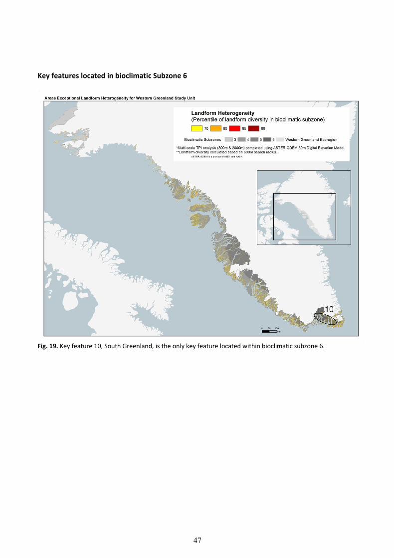
Key features located in bioclimatic Subzone 6
Fig. 19. Key feature 10, South Greenland, is the only key feature located within bioclimatic subzone 6.
48
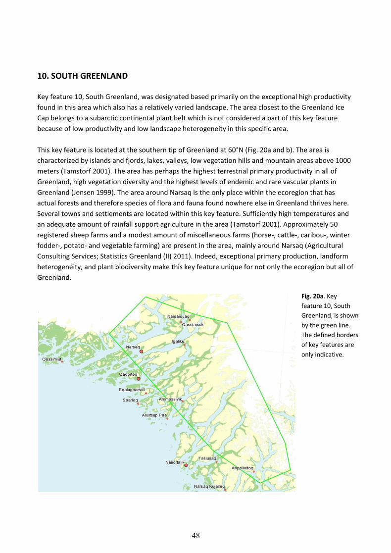
10. SOUTH GREENLAND
Key feature 10, South Greenland, was designated based primarily on the exceptional high productivity
found in this area which also has a relatively varied landscape. The area closest to the Greenland Ice
Cap belongs to a subarctic continental plant belt which is not considered a part of this key feature
because of low productivity and low landscape heterogeneity in this specific area.
This key feature is located at the southern tip of Greenland at 60°N (Fig. 20a and b). The area is
characterized by islands and fjords, lakes, valleys, low vegetation hills and mountain areas above 1000
meters (Tamstorf 2001). The area has perhaps the highest terrestrial primary productivity in all of
Greenland, high vegetation diversity and the highest levels of endemic and rare vascular plants in
Greenland (Jensen 1999). The area around Narsaq is the only place within the ecoregion that has
actual forests and therefore species of flora and fauna found nowhere else in Greenland thrives here.
Several towns and settlements are located within this key feature. Sufficiently high temperatures and
an adequate amount of rainfall support agriculture in the area (Tamstorf 2001). Approximately 50
registered sheep farms and a modest amount of miscellaneous farms (horse-, cattle-, caribou-, winter
fodder-, potato- and vegetable farming) are present in the area, mainly around Narsaq (Agricultural
Consulting Services; Statistics Greenland (II) 2011). Indeed, exceptional primary production, landform
heterogeneity, and plant biodiversity make this key feature unique for not only the ecoregion but all of
Greenland.
Fig. 20a. Key
feature 10, South
Greenland, is shown
by the green line.
The defined borders
of key features are
only indicative.

49
Fig. 20b. Satellite photo showing part of key feature 10, South Greenland, and some of the towns and
settlements in the area. Source: Moderated from NunaGis.

50
APPENDICES
Appendix 1. THE ARCTIC ECOREGIONS The arctic is home to 50 representative ecoregions that reflect the wide range of unique ecosystems
and varieties of life found throughout the far north. These regions are distinguished and located on a
map (Fig. A1) using two broad biogeographic ecological classification methods: the Circumpolar Arctic
Vegetation Map (CAVM team 2003; Walker et al. 2005) for regions on land (A) and, at sea (B), the
Marine Ecoregions of the World project (Spalding et al. 2007).
CAVM classifies the variation in plant species groups and communities found in clearly
recognizable regions across the Arctic. Although many plants occur throughout the circumpolar north,
variation in other species groups reflects the Arctic’s diverse glacial histories, topography, and other
factors that may have isolated plant populations and contributed to regional differences. Importantly,
the CAVM classes also fall into categorical distinctions according to regional differences in the soil type,
soil moisture, and temperature.
At sea, ecoregions are classified based on distinctions described by the recent Marine Ecoregions
of the World (MEOW) project. The team of international researchers involved in MEOW used
recognizable species groups of both plants and animals to make regional distinctions. Marine
ecoregions are defined as “areas of relatively homogeneous species composition that clearly differ in
this regard from adjacent systems.” These identifiable species groupings are likely the consequence of
characteristics in the seascape that encourage biological isolation and difference, such as seafloor
mountains and canyons, temperature, ice, currents, upwelling, or coastal complexity (Spalding et al.
2007).
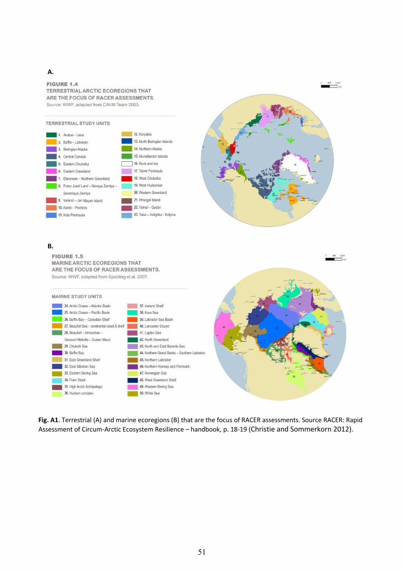
51
Fig. A1. Terrestrial (A) and marine ecoregions (B) that are the focus of RACER assessments. Source RACER: Rapid
Assessment of Circum-Arctic Ecosystem Resilience – handbook, p. 18-19 (Christie and Sommerkorn 2012).
A.
B.
52
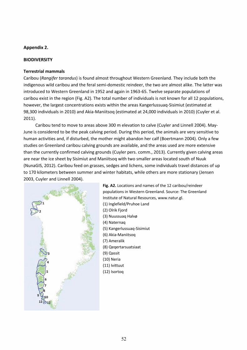
Appendix 2. BIODIVERSITY
Terrestrial mammals
Caribou (Rangifer tarandus) is found almost throughout Western Greenland. They include both the
indigenous wild caribou and the feral semi-domestic reindeer, the two are almost alike. The latter was
introduced to Western Greenland in 1952 and again in 1963-65. Twelve separate populations of
caribou exist in the region (Fig. A2). The total number of individuals is not known for all 12 populations,
however, the largest concentrations exists within the areas Kangerlussuaq-Sisimiut (estimated at
98,300 individuals in 2010) and Akia-Maniitsoq (estimated at 24,000 individuals in 2010) (Cuyler et al.
2011).
Caribou tend to move to areas above 300 m elevation to calve (Cuyler and Linnell 2004). May-
June is considered to be the peak calving period. During this period, the animals are very sensitive to
human activities and, if disturbed, the mother might abandon her calf (Boertmann 2004). Only a few
studies on Greenland caribou calving grounds are available, and the areas used are more extensive
than the currently confirmed calving grounds (Cuyler pers. comm., 2013). Currently given calving areas
are near the ice sheet by Sisimiut and Maniitsoq with two smaller areas located south of Nuuk
(NunaGIS, 2012). Caribou feed on grasses, sedges and lichens, some individuals travel distances of up
to 170 kilometers between summer and winter habitats, while others are more stationary (Jensen
2003, Cuyler and Linnell 2004).
Fig. A2. Locations and names of the 12 caribou/reindeer
populations in Western Greenland. Source: The Greenland
Institute of Natural Resources, www.natur.gl.
(1) Inglefield/Pruhoe Land
(2) Olrik Fjord
(3) Nuussuaq Halvø
(4) Naternaq
(5) Kangerlussuaq-Sisimiut
(6) Akia-Maniitsoq
(7) Ameralik
(8) Qeqertarsuatsiaat
(9) Qassit
(10) Neria
(11) Ivittuut
(12) Isortoq

53
Muskoxen (Ovibos moschatus) are indigenous to the northern and eastern parts of Greenland and
were originally absent from Western Greenland. In the 1960s, 27 individuals were transferred from
Eastern Greenland to the inner Kangerlussuaq area, northeast of Maniitsoq. The population grew and
the 2005 population estimate was 5,000-10,000 animals (Cuyler and Witting 2004, Johansen et al.
2008). Since the 1960s, muskoxen have been introduced to other parts of Western Greenland
including Kap Atholl (Qaanaaq) and Sigguk/Svartenhuk (Upernavik/Uummannaq) in the north of
Greenland, Naternaq in the north-central part, and Ivittuut in the south. The population status of these
areas is unknown4.
Muskoxen require areas with variable terrain to thrive. In the summer months they prefer low
valleys where they graze on grasses, sedges and young shoots of birch and willow, and in the winter
they move to mountain areas with shallow snow cover (Johansen et al. 2008).
Polar bears are regarded as marine mammals but are regularly seen on land from south to the north of
Greenland. Few polar bear breeds in Northwest Greenland5.
The Arctic hare and the Arctic fox are common throughout the entire Western Greenland ecoregion
(Johansen 2008).
Birds
The two most abundant species of geese in the Western Greenland ecoregion are the Greenland
White-fronted goose (Anser albifrons flavirostris) and the Canada goose (Branta canadensis). The
Greenland White-fronted goose is indigenous to the region, whereas the Canada goose made its first
appearance in the 1990s. The Greenland White-fronted goose arrives in Western Greenland in the
beginning of May, where they breed during May-June and only in this area, and leave to fly south in
September. The most important spring staging and moulting areas are located between Maniitsoq and
Upernavik. Current status of the Greenland White-fronted goose in Greenland is ‘endangered’ and
declining in numbers. This is believed to be partly due to dramatic increases in population numbers of
the Canada goose. The two species are similar in both biology and choice of habitat.
Detailed knowledge about location of spring staging and moulting areas for the Canada goose is
lacking. However, they are believed to use roughly the same areas as the Greenland White-fronted
goose (65-72°N). Their total population number is unknown but is assumed to be increasing (Johansen
et al. 2008, Jensen 2003).
The gallinaceous bird, the Rock Ptarmigan (Lagopus muta) is common and breeds in the entire region
although the population is known to fluctuate from year to year (Boertmann 2002).
4 http://www.natur.gl/en/birds-and-mammals/terrestrial-mammals/muskoxen/.
5 http://www.natur.gl/pattedyr-og-fugle/havpattedyr/isbjoern/.

54
The Arctic char and other freshwater fish species
The Arctic char (Salvelinus alpines) is common in streams and fresh water lakes throughout the
Western Greenland ecoregion, where it functions as a top predator, and it is often the only fish
present in the relatively simple ecosystems of Arctic lakes and streams. The Arctic char exists in two
forms: an anadromous form that spends the summer in the sea and migrates to fresh water streams in
the winter to breed, and a landlocked form that spends all its life in freshwater. The anadromous form
has a faster growth rate and is therefore most important in relation to fishing activities (Johansen et al.
2008). To spawn successfully the anadromous form requires deep pools that do not freeze in winter
and streams with enough water flow to supply the eggs with sufficient amounts of oxygen (Boertmann
2004).
The three-spined stickleback (Gasterosteus aculeatus) is common in both fresh and salt water within
the ecoregion.
There is only one spawning-ground for salmon in Greenland. It is located in the river near Kapisillit in
south-western Greenland (Johansen et al. 2008).
The American eel (Anguilla rostrata) is rare in Greenland but can be found in the lakes of south-
western Greenland.

55
Appendix 3
GLOBAL CLIMATE MODELLING
RACER uses forecasts from current General Circulation Models (GCMs) to predict climate-related
changes to ecologically significant variables within ecoregions for the remainder of this century.
GCMs are a broad group of internationally developed computerized models designed and tested to
forecast likely effects of global climate change on rain, snow, temperature, ice, and many other
variables for different greenhouse gas emission scenarios into the future. GCMs form the basis of the
predictions and warnings by the intergovernmental panel on Climate Change (IPCC 2007).
Although the unique relationship between the ocean, land, and atmosphere in the Arctic often
complicates these forecasts (e.g., through unexpected lag periods or difficult-to-anticipate climate
feedbacks), the prediction accuracy of several GCMs has been proven in the region. RACER relies on
data from four of these models that have shown the best agreement between climate projections and
reality in the Arctic. Similarly, RACER uses GCM results for a realistic greenhouse gas emission scenario
that reflects a “business as usual” outlook. The so-called A2 scenario offers results for all four selected
GCMs (Fig. A3A). The scenario matches current observations closely and projects a degree of warming
for the year 2100 in line with predictions resulting from current global commitments to the reduction
of greenhouse gas emissions.
Twenty variables were selected from the GCM data for the RACER analysis. Variable values
relevant to the ecoregions were then calculated from nearby GCM values using a weighted average
from the GCM data grid to accommodate the irregular shape of the region (Fig. A3B). The details of
this method are described in Huard 2010.
Fig. A3. A. Cabon emissions projected by IPCC SRES A2 scenario and actual global carbon emissions. B. example
of how climate variables are scaled from node points to ecoregions (See also RACER: Rapid Assessment of
Circum-Arctic Ecosystem Resilience – handbook (Christie and Sommerkorn 2012). Link to handbook:
wwf.panda.org/arctic/racer).
56
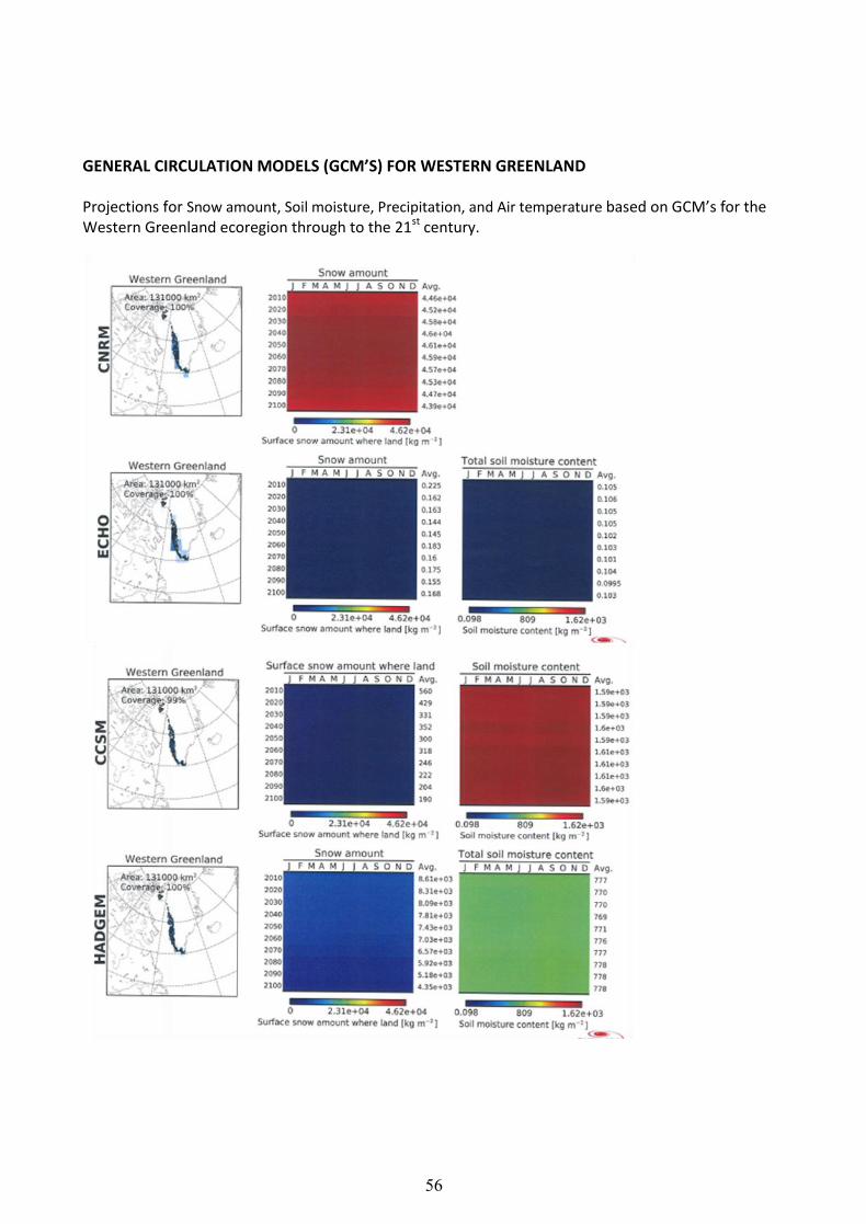
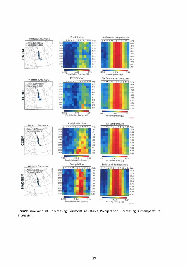
GENERAL CIRCULATION MODELS (GCM’S) FOR WESTERN GREENLAND
Projections for Snow amount, Soil moisture, Precipitation, and Air temperature based on GCM’s for the Western Greenland ecoregion through to the 21st century.
57
Trend: Snow amount – decreasing; Soil moisture - stable; Precipitation – increasing; Air temperature – increasing.
58
Taxon Taxon continued Taxon continued
Agrostis mertensii Draba sp. Poa alpina
Alnus crispa Dryas integrifolia Poa glauca
Alopecurus aequalis Dryopteris assimilis Poa pratensis
Angelica archangelica ssp. norvegica Empetrum nigrum ssp. Hermaphroditum Polygonum viviparum
Antennaria angustata Epilobium anagallidifolium Potamogeton alpinus ssp. tenuifolia
Antennaria canescens Epilobium palustre Potentilla crantzii
Antennaria glabrata Equisetum arvense Potentilla egedii
Armeria scabra ssp. sibirica Equisetum sylvaticum Potentilla hookeriana
Artemisia borealis Equisetum variegatum Potentilla nivea
Bartsia alpina Erigeron humilis Potentilla tridentata
Betula glandulosa Erigeron uniflorus Primula stricta
Betula nana Eriophorum angustifolium ssp. subarcticum Puccinellia phryganodes
Botrychium lunaria Eriophorum scheuchzeri Puccinellia cfr. coarctata
Calamagrostis langsdorffii Euphrasia frigida Puccinellia sp.
Calamagrostis neglecta Festuca brachyphylla Pyrola grandiflora
Calamagrostis hyperborea Festuca rubra Pyrola minor
Callitriche palustris Festuca vivipara Ranunculus confervoides
Campanula gieseckiana Gentiana nivalis Ranunculus hyperboreus
Campanula uniflora Gnaphalium norvegicum Ranunculus pygmaeus
Cardamine bellidifolia Gnaphalium supinum Ranunculus reptans
Cardamine pratensis Gymnocarpium dryopteris Rhododendron lapponicum
Carex bigelowii Harrimanella hypnoides Rhodiola rosea
Carex brunnescens Hieracium hyparcticum Rumex acetosella
Carex canescens Hierochloë alpina Sagina caespitosa
Carex capillaris Hippuris vulgaris Salix arctophila
Carex capitata ssp. arctogena Huperzia selago Salix glauca
Carex deflexa Isoëtes echinospora ssp. muricata Salix herbacea
Carex glacialis Juncus arcticus Salix uva-ursi
Carex glareosa Juncus biglumis Saxifraga aizoides
Carex gynocrates Juncus castaneus Saxifraga caespitosa
Carex lachenalii Juncus trifidus Saxifraga cernua
Carex macloviana Juncus triglumis Saxifraga foliolosa
Carex misandra Juniperus communis ssp. alpina Saxifraga hyperborea
Carex nardina Kobresia myosuroides Saxifraga nivalis
Carex norvegica Koenigia islandica Saxifraga paniculata
Carex rariflora Ledum groenlandicum Saxifraga oppositifolia
Carex rufina Ledum palustre ssp. decumbens Saxifraga tenuis
Carex rupestris Leymus mollis Saxifraga sp. (tenuis/nivalis)
Carex saxatilis Limosella aquatica Saxifraga tricuspidata
Carex scirpoidea Loiseleuria procumbens Scirpus caespitosus
Carex subspathacea Lomatogonium rotatum Sibbaldia procumbens
Carex supina ssp. spaniocarpa Luzula arctica Silene acaulis
Cassiope tetragona Luzula confusa Sparganium hyperboreum
Cerastium alpinum Luzula groenlandica Stellaria calycantha
Cerastium cerastoides Luzula multiflora Stellaria crassipes
Chamaenerion angustifolium Luzula parviflora Stellaria humifusa
Chamaenerion latifolium Luzula spicata Stellaria longipes
Cochlearia groenlandica Lycopodium annotinum Stellaria sp.
Comarus palustre Menyanthes trifoliata Taraxacum lacerum
Coptis trifolia Minuartia biflora Taraxacum sp.
Corallorhiza trifida Minuartia groenlandica Thalictrum alpinum
Cystopteris fragilis Minuartia rubella Thymus praecox ssp. arcticus
Deschampsia flexuosa Montia fontana ssp. fontana Tofieldia pusilla
Deschampsia pumila Oxycoccus palustris ssp. microphyllus Triglochin palustre
Diapensia lapponica ssp. lapponica Oxyria digyna Trisetum spicatum
Diphasiastrum alpinum Papaver radicatum Trisetum triflorum
Diphasiastrum complanatum Pedicularis flammea Vaccinium uliginosum
Draba aurea Pedicularis hirsuta Vahlodea atropurpurea
Draba cana Pedicularis labradorica Veronica alpina
Draba cinerea Pedicularis lapponica Veronica wormskjoldii
Draba crassifolia Phegopteris connectilis Viola sp.
Draba glabella Phippsia algida Viscaria alpina
Draba nivalis Phyllodoce coerulea Woodsia ilvensis
Draba norvegica Plantago maritima ssp. borealis
Appendix 4. Flora list of the study areas, 2011-2012, related to the Isua mining project. Modified from Bay and Simonsen 2013.
59
LITERATURE CITED
Bay, D. and Simonsen, C.E. 2013. Botanical investigations related to the Isua mining project, 2011-
2012. Aarhus University, DCE – Danish Centre for Environment and Energy, 38 pp. Technical Report
from DCE – Danish Centre for Environment and Energy No. 25. http://dce2.au.dk/pub/TR25.pdf
Boertmann, D. 2002. Fugle i Grønland. Ilinniusiorfik Undervisningsmiddelforlag. 80 pp.
Boertmann, D. (ed.). 2004. Background studies in Nuussuaq and Disko, West Greenland. NERI Technical
Report No. 482: 58 pp.
Born, E. W., and Böcher, J. 1999: Grønlands Økologi – en grundbog. Atuakkiorfik Undervisning, 431 s.
CAVM Team 2003. Circumpolar Arctic Vegetation Map (1:7,500,000 scale). Conservation of Arctic Flora
and Fauna (CAFF), Map No. 1. U.S. Fish and Wildlife Service, Anchorage, Alaska.
Christie, P. and Sommerkorn, M. 2012. RACER: Rapid Assessment of Circum-Arctic Ecosystem Resilience, 2nd Ed. Ottawa, Canada: WWF Global Arctic Programme. 72 pp. Download: wwf.panda.org/arctic/racer.
Cuyler, C. and Linnell, J. D. C. 2004. Årlig vandringsmønster hos satellitmærkede rensdyr i
Vestgrønland. Kapitel 6: p. 189-210 – In: Aastrup, P. (ed.) Samspillet mellem rensdyr, vegetation og
menneskelige aktiviteter i Vestgrønland. Greenland Institute of Natural Resources. Technical report
No. 49: 321 pp.
Cuyler, C., Rosing, M., Heinrich, R., Egede, J. and Mathæussen, L. 2007. Status of two West Greenland
caribou populations 2006, 1) Ameralik, 2) Qeqertarsuatsiaat. Greenland Institute of Natural Resources.
Technical report No. 67: 143 pp.
Cuyler, C., Rosing, M., Mølgaard, H., Heinrich, R. and Raundrup, K. 2011; revised 2012. Status of two
west Greenland caribou populations 2010; 1) Kangerlussuaq-Sisimiut and 2) Akia-Maniitsoq. Greenland
Institute of Natural Resources. Technical Report No. 78: 158 pp.
Cuyler, L. C. and Witting, L. 2004. Kangerlussuaq (Angujaartorfiup Nunaa) muskox in West Greenland:
Possible harvests for 2005, 2006, 2007 and herd status 2004. Kingsley, M. C. S. (ed.). Advisory
document prepared for the Directorate for Environment and Nature. Greenland Institute of Natural
Resources, Nuuk. 01 December, 2004. Brev. Nr. 02250, J. Nr. 4000.01.03: 16 pp.

60
Jensen, D. B. 2003. The Biodiversity of Greenland – a country study. Grønlands Naturinstitut, Technical
Report no. 55.
Johansen, P., Aastrup, P., Boertmann, D., Glahder, C., Johansen, K., Nymand, J., Rasmussen, L. M. and
Tamstorf, M. 2008: Aluminiumsmelter og vandkraft i det centrale Vestgrønland. Danmarks
Miljøundersøgelser, Aarhus Universitet. Faglig rapport fra DMU nr. 664. 110 s.
http://www.dmu.dk/Pub/FR664.pdf
Landa, A., Gravlund, P., Cuyler, C. and Jeremiassen, S. 2000a. Er rensdyr på Inglefield Land mest
beslægtet med de vestgrønlandske rener eller Peary rener? Grønlands Naturinstitut. Teknisk rapport
Nr. 33: 19 s.
Landa, A., Jeremiassen, S. R. and Andersen, R. 2000b. Rensdyr og moskusokser i Inglefield Land,
Nordvestgrønland. Grønlands Naturinstitut. Teknisk rapport nr. 31: 21 s.
Normand, S. et al. 2013. A greener Greenland? Climatic potential and long-term constraints on
future expansions of trees and shrubs. Phil. Trans. R. Soc. B 368, 20120479 (doi: 10.1098/rstb.
2012.0479).
Normand, S., Forchhammer, M. C., Høye, T. T., Jeppesen, E., and Svenning, J-C. 2012. Grønlands
biodiversitet: klimaets betydning i fortid, nutid og fremtid. In: M. Akhøj Nielsen (ed.), Grønlands
fascinationskraft. Det Kongelige Danske Videnskabernes Selskab, s. 148-162.
NunaGIS. Caribou calving ranges DCE. Retrieved May 2012. http://en.nunagis.gl/
Statistics Greenland (I). 2010. Precipitation by time, weather station and month, matrix MIE1NED,
updated 2010.
Statistics Greenland (II). 2011. Total landings of meat from land mammals after year, municipality, species, unit and month, matrix FIE004, updated 2011.
Tamstorf, M.P. 2001. Satellitbaseret vegetationskortlægning i Vestgrønland. PhD afhandling, Danmarks
Miljøundersøgelser. 237 s. http://www.dmu.dk/1_Viden/2_publikationer/3_Ovrige/default.asp.