Embed Size (px)
DESCRIPTION
Tríptico con rutas submarinistas en los fondos marinos de Benidorm
Citation preview
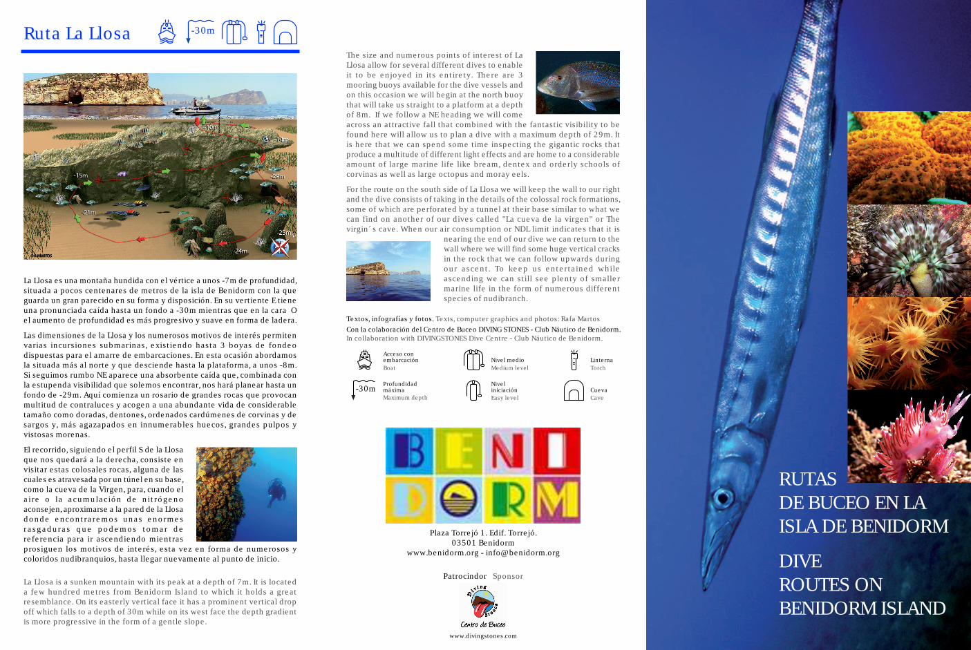
La Llosa es una montaña hundida con el vértice a unos -7m de profundidad,situada a pocos centenares de metros de la isla de Benidorm con la queguarda un gran parecido en su forma y disposición. En su vertiente E tieneuna pronunciada caída hasta un fondo a -30m mientras que en la cara Oel aumento de profundidad es más progresivo y suave en forma de ladera.
Las dimensiones de la Llosa y los numerosos motivos de interés permitenvarias incursiones submarinas, existiendo hasta 3 boyas de fondeodispuestas para el amarre de embarcaciones. En esta ocasión abordamosla situada más al norte y que desciende hasta la plataforma, a unos -8m.Si seguimos rumbo NE aparece una absorbente caída que, combinada conla estupenda visibilidad que solemos encontrar, nos hará planear hasta unfondo de -29m. Aquí comienza un rosario de grandes rocas que provocanmultitud de contraluces y acogen a una abundante vida de considerabletamaño como doradas, dentones, ordenados cardúmenes de corvinas y desargos y, más agazapados en innumerables huecos, grandes pulpos yvistosas morenas.
El recorrido, siguiendo el perfil S de la Llosaque nos quedará a la derecha, consiste envisitar estas colosales rocas, alguna de lascuales es atravesada por un túnel en su base,como la cueva de la Virgen, para, cuando elaire o la acumulación de nitrógenoaconsejen, aproximarse a la pared de la Llosadonde encontraremos unas enormesrasgaduras que podemos tomar dereferencia para ir ascendiendo mientrasprosiguen los motivos de interés, esta vez en forma de numerosos ycoloridos nudibranquios, hasta llegar nuevamente al punto de inicio.
Ruta La Llosa -30m
La Llosa is a sunken mountain with its peak at a depth of 7m. It is locateda few hundred metres from Benidorm Island to which it holds a greatresemblance. On its easterly vertical face it has a prominent vertical dropoff which falls to a depth of 30m while on its west face the depth gradientis more progressive in the form of a gentle slope.
The size and numerous points of interest of LaLlosa allow for several different dives to enableit to be enjoyed in its entirety. There are 3mooring buoys available for the dive vessels andon this occasion we will begin at the north buoythat will take us straight to a platform at a depthof 8m. If we follow a NE heading we will comeacross an attractive fall that combined with the fantastic visibility to befound here will allow us to plan a dive with a maximum depth of 29m. Itis here that we can spend some time inspecting the gigantic rocks thatproduce a multitude of different light effects and are home to a considerableamount of large marine life like bream, dentex and orderly schools ofcorvinas as well as large octopus and moray eels.
For the route on the south side of La Llosa we will keep the wall to our rightand the dive consists of taking in the details of the colossal rock formations,some of which are perforated by a tunnel at their base similar to what wecan find on another of our dives called "La cueva de la virgen" or Thevirgin´s cave. When our air consumption or NDL limit indicates that it is
nearing the end of our dive we can return to thewall where we will find some huge vertical cracksin the rock that we can follow upwards duringour ascent. To keep us entertained whileascending we can still see plenty of smallermarine life in the form of numerous differentspecies of nudibranch.
-30m
Boat
Profundidadmáxima
Acceso conembarcación
Maximum depth
Textos, infografías y fotos. Texts, computer graphics and photos: Rafa Martos
www.divingstones.com
RUTASDE BUCEO EN LAISLA DE BENIDORM
DIVEROUTES ONBENIDORM ISLAND
Patrocindor Sponsor
Torch
Cave
Linterna
Cueva
Medium level
Easy level
Nivel medio
Niveliniciación
Con la colaboración del Centro de Buceo DIVING STONES - Club Náutico de Benidorm.In collaboration with DIVINGSTONES Dive Centre - Club Náutico de Benidorm.
Plaza Torrejó 1. Edif. Torrejó.03501 Benidorm
www.benidorm.org - [email protected]
Ruta los Arcos
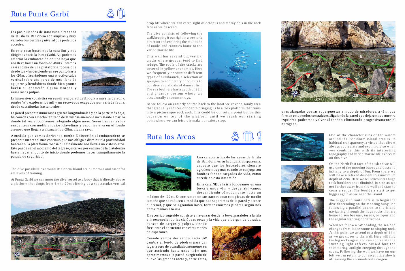
Una característica de las aguas de la islade Benidorm es su habitual transparencia,aspecto que los buceadores siempreagradecemos y más cuando se conjuga conbonitos fondos cargados de vida, comosucede en esta inmersión.
En la cara NE de la isla fondeamos en unaboya a unos -6m y desde ahí vamosdescendiendo cómodamente hasta un
máximo de -22m. Encontramos un sustrato rocoso con piezas de mediotamaño que se reducen a medida que nos separamos de la pared y acreceel arenal, y que se agrandan hasta formar enormes piedras según nosaproximamos a la isla.
El recorrido sugerido consiste en avanzar desde la boya, paralelos a la islae ir reconociendo las ciclópeas rocas y la vida que albergan de doradas,bancos de sargos y pulpos, siendofrecuente el encuentro con cardúmenesde espetones.
Cuando vamos derivando hacia SWcambia el fondo de piedras para darlugar a otro de acantilado, momento enque asciendo hasta unos -14m nosaproximamos a la pared, surgiendo denuevo las grandes rocas y, entre éstas,
drop off where we can catch sight of octopus and moray eels in the rockface as we descend.
The dive consists of following thewall, keeping it our right in a westerlydirection and exploring the multitudeof nooks and crannies home to thevaried marine life.
This wall has several big verticalcracks where grouper tend to findrefuge. The roofs of the cracks arecovered in yellow anenomies. Herewe frequently encounter differenttypes of nudibranch, a selection ofsponges to add plenty of colours toour dive and shoals of damsel fish.The sea bed here has a depth of 28mand a sandy bottom where weoccasionally encounter rays.
As we follow an easterly course back to the boat we cover a sandy areathat gradually reduces our depth bringing us to a rock platform that turnsinto a picturesque rock arch. This could be our return point but on thisoccasion on top of the platform until we reach our startingpoint where we can leisurely make our safety stop.
One of the characteristics of the watersaround the Benidorm island area is itshabitual transparency, a virtue that diversalways appreciate and even more so whenyou combine this with its interestingtopography and varied marine life as occurson this dive.
On the North East face of the island we willuse one of the mooring buoys and descendinitially to a depth of 6m. From there wewill make a relaxed descent to a maximumdepth of 22m. Here we will encounter hugerock boulders that diminish in size as weget further away from the wall and start tocross a sandy. The boulders start to getbigger again as we near the island.
The suggested route here is to begin thedive descending on the mooring buoy linefollowing a parallel course to the islandnavigating through the huge rocks that arehome to sea breams, sargos, octopus andthe regular sighting of barracuda.
When we follow a SW heading, the sea bedchanges from loose stone to sloping rock.At this point we ascend to a depth of 14mas we get closer to the wall. Here will findthe big rocks again and can appreciate thestunning light effects caused bun theshimmering sunlight creeping through thecaves. Following the wall we have on ourleft we can return to our ascent line slowlyoff gassing the accumulated nitrogen.
unas alargadas cuevas superpuestas a modo de miradores, a -9m, queforman estupendos contraluces. Siguiendo la pared que dejaremos a nuestraizquierda podremos volver al fondeo eliminando progresivamente elnitrógeno.
The dive possibilities around Benidorm Island are numerous and cater forall levels of training.
At Punta Garbí we can moor the dive vessel to a buoy that is directly abovea platform that drops from 4m to 20m offering us a spectacular vertical
Las posibilidades de inmersión alrededorde la isla de Benidorm son amplias y muyvariados los perfiles y nivel al que podemosacceder.
En este caso buscamos la cara Sur y nosdirigimos hacia la Punta Garbí. Allí podemosamarrar la embarcación en una boya quenos lleva hasta un fondo de -8mts. Estamoscasi encima de una plataforma rocosa quedesde los -4m desciende en ese punto hastalos -20m, ofreciéndonos una atractiva caídavertical sobre una pared de roca llena deagujeros y hendiduras donde bien prontohacen su aparición alguna morena ynumerosos pulpos.
La inmersión consistirá en seguir esa pared dejándola a nuestra derecha,rumbo W y explorar los mil y un recovecos ocupados por variada fauna,desde castañuelas hasta tordos.
La pared presenta numerosas grietas longitudinales y en la parte más baja,balconadas con el techo tapizado de la vistosa anémona incrustante amarilladonde tal vez encontremos refugiado algún mero. Serán frecuentes losencuentros con nudibranquios, clavelinas y esponjas y ya en el fondoarenoso que llega a a alcanzar los -28m, alguna raya.
A medida que vamos derivando rumbo E dirección al embarcadero sepresenta un arenal más continuo que nos obliga a disminuir la profundidadbuscando la plataforma rocosa que finalmente nos lleva a un vistoso arco.Este puede ser el momento del regreso, esta vez por encima de la plataformahasta llegar al punto de inicio donde podemos hacer tranquilamente laparada de seguridad.
Ruta Punta Garbí