Embed Size (px)
Citation preview
ISSN: 2148-9173 Vol: 8 Issue:1 March 2021
International Journal of Environment and Geoinformatics (IJEGEO) is an international, multidisciplinary, peer reviewed, open access journal.
Chief in Editor
Prof. Dr. Cem Gazioğlu
Co-Editors
Prof. Dr. Dursun Zafer Şeker, Prof. Dr. Şinasi Kaya, Prof. Dr. Ayşegül Tanık and Assist. Prof. Dr. Volkan Demir
Guest EditorAssoc. Prof. Dr. Nedim Onur Aykut
Editorial Committee (January 2021)
Assoc. Prof. Dr. Abdullah Aksu (TR), Assit. Prof. Dr. Uğur Algancı (TR), Prof. Dr. Bedri Alpar (TR), Assoc. Prof. Dr. Aslı Aslan (US), Prof. Dr. Levent Bat (TR), Prof. Dr. Paul Bates (UK), İrşad Bayırhan (TR), Prof. Dr. Bülent Bayram (TR), Prof. Dr. Luis M. Botana (ES), Prof. Dr. Nuray Çağlar (TR), Prof. Dr. Sukanta Dash (IN), Dr. Soofia T. Elias (UK), Prof. Dr. A. Evren Erginal (TR), Assoc. Prof. Dr. Cüneyt Erenoğlu (TR), Dr. Dieter Fritsch (DE), Prof. Dr. Çiğdem Göksel (TR), Prof.Dr. Lena Halounova (CZ), Prof. Dr. Manik Kalubarme (IN), Dr. Hakan Kaya (TR), Assist. Prof. Dr. Serkan Kükrer (TR), Assoc. Prof. Dr. Maged Marghany (MY), Prof. Dr. Michael Meadows (ZA), Prof. Dr. Nebiye Musaoğlu (TR), Prof. Dr. Masafumi Nakagawa (JP), Prof. Dr. Hasan Özdemir (TR), Prof. Dr. Chryssy Potsiou (GR), Prof. Dr. Erol Sarı (TR), Prof. Dr. Maria Paradiso (IT), Prof. Dr. Petros Patias (GR), Prof. Dr. Elif Sertel (TR), Prof. Dr. Nüket Sivri (TR), Prof. Dr. Füsun Balık Şanlı (TR), Prof. Dr. Uğur Şanlı (TR), Duygu Ülker (TR), Prof. Dr. Seyfettin Taş (TR), Assoc. Prof. Dr. Ömer Suat Taşkın (TR), Assist. Prof. Dr. Tuba Ünsal (TR), Dr. Manousos Valyrakis (UK), Dr. İnese Varna (LV), Dr. Petra Visser (NL), Prof. Dr. Selma Ünlü (TR), Assoc. Prof. Dr. Oral Yağcı (TR), Prof. Dr. Murat Yakar (TR), Assoc. Prof. Dr. İ. Noyan Yılmaz (AU); Assit. Prof. Dr. Sibel Zeki (TR)
Abstracting and Indexing: TR DIZIN, DOAJ, Index Copernicus, OAJI, Scientific Indexing Services, International Scientific Indexing, Journal Factor, Google Scholar, Ulrich's Periodicals Directory, WorldCat, DRJI, ResearchBib, SOBIAD
Selection of the Most Proper Unmanned Aerial Vehicle for Transportation in Emergency Operations by Using Analytic Hierarchy Process
Mustafa ULUKAVAK, Mehmet MIMAN
Dear colleagues and friends,
International Symposium on Applied Geoinformatics (ISAG2019) was held in Istanbul on 7-9 November 2019.
The symposium is organized with the aim of promoting the advancements to explore the latest scientific and
technological developments and opportunities in the field of Geoinformatics.
The symposium was jointly organized by the Department of Geomatics Engineering, Yıldız Technical
University, Istanbul, Turkey and the Institute of Geodesy and Geoinformatics, University of Latvia, Riga-
Latvia.
Our main aim was to bring researchers to share knowledge and their expertise about state-of-art developments in the
field of Geoinformatics. We wish to discuss the latest developments, opportunities and challenges that can help the
Geoinformatics community to solve many real-world challenges. Although this forum is initiated by two countries,
Turkey and Latvia, it has a global perspective to promote technologies and advancements that would help us live in
a better world.
290 participants and scientists from 27 countries were attended to the ISAG2019. 118 oral and 16 poster
presentations were presented by 45 international and 89 Turkish presenters in 29 sessions between 7-9
November 2019.
We are much thankful to our supporting institutions Turkish General Directorate of Mapping, The Embassy of
Latvia in Turkey, General Directorate of Geographical Information Systems/Turkey, Fatih Municipality.
The presentation "XXX" was presented at the ISAG2019 and was proposed by our scientific committee for
evaluation in the International Journal of Environmental and Geoinformatics (IJEGEO).
The next ISAG symposium will be organized in Riga, Latvia on 16-17 November 2021. I do really hope to see
you all in Latvia at the 2nd
ISAG Symposium.
On behalf of ISAG-2019 Organization Committee
Conference Chair
Prof. Dr. Bülent Bayram
78
Selection of the Most Proper Unmanned Aerial Vehicle for Transportation in
Emergency Operations by Using Analytic Hierarchy Process
Mustafa Ulukavak1,*
, Mehmet Miman2
1 Harran University, Faculty of Engineering, Geomatics Engineering, Şanlıurfa, Turkey 2 Harran University, Faculty of Engineering, Industrial Engineering, Şanlıurfa, Turkey
Corresponding author: M. Ulukavak * E-mail: [email protected]
Received 30 June 2020
Abstract
Today rapid development on Unmanned Aerial Vehicle (UAV) technologies continues to evolve and expand its use as a tool that can
be used in many fields. The most communal areas for the use of UAV are mapping, assessing, and supporting damage assessments,
and search and rescue activities, respectively. However, the application of transporting light and important cargoes that have become
widespread recently accessing to the difficult areas is also becoming a new sector in the usage areas of UAV. Lightweight, user-
friendly designs of UAVs and flight systems managed by automated workflows giving convenience for this field application. In this
study, two different flight platforms (3 fixed-wing and 3 multi-rotor) of flight parameters were evaluated by selecting the sales
catalog. Brand knowledge of the UAVs has not given into consideration of the belief that it may adversely affect commercial
competition. The sample modeled as a multi-criteria decision-making problem consisting of quantitative and qualitative criteria, and
the analytic hierarchy process (AHS), which clearly reveals the decision-makers' views for such problems. Priorities for the criteria
of each alternative for the payload, UAV weight, maximum altitude, maximum speed, flight time, and controller range criteria with
numerical performance values in order to maintain the consistency problem in the AHS method were figured out by direct
assignment. The impact of each criterion in the choice and coherence analysis to determine the effect of each alternative criteria were
performed using Expert Choice v2000 software. Because of the analysis made, it is seen that multi-rotor UAVs are the predominant
choice for fixed-winged UAVs, among which the UAV_4 flight platform is the most appropriate vehicle for emergency transport
with an overall weight of 0.2530. When UAV_4 is compared with other alternative flight platforms, it is seen to be in the foreground
according to the criteria of maximum altitude, maximum ground speed, landing field, and ease of use. As seen in the analysis of 2-
dimensional alternatives at the end of the example, analysis of UAV to be used in emergency transport according to the landing field
and ease of use criteria revealed that multi-rotor UAVs (UAV_4, UAV_5, UAV_6) have more dominant results than fixed-wing
UAVs (UAV_1, UAV_2, UAV_3). Although most of the UAV models being developed are still in prototypes, with the rapid
development in the field of technology and the industrial knowledge in these applications, further progress can be expected in future
projects.
Keywords: Unmanned Aerial Vehicle, Emergency Operations, Expert Choice, Analytic Hierarchy Process, Multi-Criteria Decision-
Making
Introduction
In the twentieth century, remotely controlled air vehicles
were not common, but in the twenty-first century, the
use of these vehicles flared very quickly. Large-scale
unmanned aerial vehicles (UAVs) have been used by
various countries for military purposes. Today, the
capabilities of the small size of the UAVs have greatly
increased and production costs have been significantly
reduced. The UAVs have recently been among the most
advanced systems in civilian areas of use. Over the past
few years, the increase in small-scale UAV applications
has become widespread to carry through the needs of
more expensive and complex human aircraft systems
(Segui-Gasco et al., 2014). This has led to additional
investments and a wider market of small UAVs and has
resulted in a significant increase compared to costs in
UAV (Clarke, 2014; Erenoğlu and Erenoğlu, 2018;
Bayırhan and Gazioğlu, 2019;Karataş and Altınışık,
2020; Utlu and Öztürk, 2020). Nowadays, there are three
several types of UAV systems produced. These are the
fixed-wing, multi-rotor, and hybrid flight platform
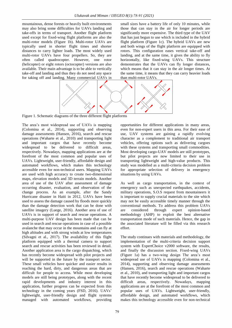
systems, respectively (Figure 1).
Fixed-wing UAVs (Figure 1a) has a two-wing design
and is often used to carry heavy loads. Fixed-wing
UAVs is preferred for projects that need to transport
cargo over longer distances. They can run in winds up to
50 km/h and can usually stay in the air approximately 30
minutes to several hours depending on the model. Most
fixed-wing UAV flies with the auto-pilot mode by
following pre-determined flight paths that are loaded
into the UAV before the flight. The pilot on the ground
checks the flight route and makes minor adjustments
when necessary and monitors emergency conditions. A
significant disadvantage of fixed-wing UAVs is that they
usually need the use of an open area (track) for landing
and launch. The presence of transportation areas in
International Journal of Environment and Geoinformatics 8(1):078-091 (2021)
Reaserch Article
How to cite: Ulukavak and Miman (2021). Selection of the Most Proper Unmanned Aerial Vehicle for Transportation in Emergency Operations
by Using Analytic Hierarchy Process, International Journal of Environment and Geoinformatics (IJEGEO), 8(1): 078-091, doi: 10.30897/
ijegeo.760758
Accepted 30 Nov 2020
Ulukavak and Miman / IJEGEO 8(1):78-91 (2021)
79
mountainous, dense forests or heavily built environments
may also bring some difficulties for UAVs landing and
take-offs in terms of transport. Another flight platform
used except for fixed-wing flight platforms are also the
multi-rotor models (Figure 1b). Multi-rotor UAVs are
typically used in shorter flight times and shorter
distances to carry lighter loads. The most widely used
multi-rotor UAVs have four propellers. So, they are
often called quadrocopter. However, one rotor
(helicopter) or eight rotors (octocopter) versions are also
available. Their main advantage is to be able to vertically
take-off and landing and thus they do not need any space
for taking off and landing. Many commercial UAVs in
small sizes have a battery life of only 10 minutes, while
those that can stay in the air for longer periods are
significantly more expensive. The third type of the UAV
that has just begun to use which is included in the hybrid
flight platform (Figure 1c). The hybrid UAVs are new
and both wings of the flight platform are equipped with
rotors. This configuration eases vertical take-off and
landing, and at the same time, it gives the ability to fly
horizontally, like fixed-wing UAVs. This structure
demonstrates that the UAVs can fly longer distances,
which means that it can stay in the air longer times. At
the same time, it means that they can carry heavier loads
than multi-rotor UAVs.
Figure 1. Schematic diagrams of the three different flight platforms
The area’s most widespread use of UAVs is mapping
(Colomina et al., 2014), supporting and observing
damage assessments (Hansen, 2016), search and rescue
operations (Waharte et al., 2010) and transporting light
and important cargos that have recently become
widespread to be delivered to difficult areas,
respectively. Nowadays, mapping applications are at the
forefront of the most common and popular uses of
UAVs. Lightweight, user-friendly, affordable design and
automated workflows, which makes this technology
accessible even for non-technical users. Mapping UAVs
are used with high accuracy to create two-dimensional
maps, elevation models and 3D terrain models. Another
area of use of the UAV after assessment of damage
occurring disaster, evaluation, and observation of the
change process. As an example, after the Sandy
Hurricane disaster in Haiti in 2012, UAVs have been
used to assess the damage caused by floods more quickly
than the damage detection work that can be done with
satellite imagery (Luege, 2016). Another area of use of
UAVs is in support of search and rescue operations. A
multi-purpose UAV design has been made that can be
used in search and rescue operations in case of a possible
avalanche that may occur in the mountains and can fly at
high altitudes and with strong winds at low temperatures
(Silvagni et al., 2017). The availability of this flight
platform equipped with a thermal camera to support
search and rescue activities has been reviewed in detail.
Another application area is the cargo dispatching, which
has recently become widespread with pilot projects and
will be supported in the future by the transport sector.
These small vehicles have quicker and easier results in
reaching the hard, dirty, and dangerous areas that are
difficult for people to access. While most developing
models are still being prototypes, along with the recent
rapid developments and industry interest in this
application, further progress can be expected from this
technology in the coming years (FSD, 2016). UAVs’
lightweight, user-friendly design and flight systems
managed with automated workflows, providing
opportunities for different applications in many areas,
even for non-expert users in this area. For their ease of
use, UAV systems are gaining a rapidly evolving
character as a complement to traditional air transport
vehicles, offering options such as delivering cargoes
with these systems and transporting small commodities.
Most developing cargo-UAV models are still prototypes,
but pilot projects are now limited to their use in
transporting lightweight and high-value products. This
study was modelled as a multi-criteria decision problem
for appropriate selection of delivery in emergency
situations by using UAVs.
As well as cargo transportation, in the context of
emergency such as unexpected earthquakes, accidents,
military operations, S.O.S request from mountaineers it
is important to supply crucial materials to the site which
may not be easily accessible timely manner through the
conventional methods. To address this problem UAVs
are considered through expert opinion-based
methodology (AHP) to exploit the best alternative
transportation mode of such materials. Hence, the gap in
the associated literature will be filled via this research
effort.
The study continues with materials and methodology, the
implementation of the multi-criteria decision support
system with ExpertChoice v2000 software, the results,
and finally the discussion section. Fixed-wing UAVs
(Figure 1a) has a two-wing design The area’s most
widespread use of UAVs is mapping (Colomina et al.,
2014), supporting and observing damage assessments
(Hansen, 2016), search and rescue operations (Waharte
et al., 2010), and transporting light and important cargos
that have recently become widespread to be delivered to
difficult areas, respectively. Nowadays, mapping
applications are at the forefront of the most common and
popular uses of UAVs. Lightweight, user-friendly,
affordable design, and automated workflows, which
makes this technology accessible even for non-technical
Ulukavak and Miman / IJEGEO 8(1):78-91 (2021)
80
users. Mapping UAVs are used with high accuracy to
create two-dimensional maps, elevation models, and 3D
terrain models. Another area of use of the UAV after
assessment of damage occurring disaster, evaluation, and
observation of the change process. As an example, after
the Sandy Hurricane disaster in Haiti in 2012, UAVs
have been used to assess the damage caused by floods
more quickly than the damage detection work that can be
done with satellite imagery (Luege, 2016). Another area
of use of UAVs is in support of search and rescue
operations. A multi-purpose UAV design has been made
that can be used in search and rescue operations in case
of a possible avalanche that may occur in the mountains
and can fly at high altitudes and with strong winds at low
temperatures (Silvagni et al., 2017). The availability of
this flight platform equipped with a thermal camera to
support search and rescue activities has been reviewed in
detail. Another application area is cargo dispatching,
which has recently become widespread with pilot
projects and will be supported in the future by the
transport sector. These small vehicles have quicker and
easier results in reaching the hard, dirty, and dangerous
areas that are difficult for people to access. While most
developing models are still being prototypes, along with
the recent rapid developments and industry interest in
this application, further progress can be expected from
this technology in the coming years (FSD, 2016). UAVs’
lightweight, user-friendly design and flight systems
managed with automated workflows, providing
opportunities for different applications in many areas,
even for non-expert users in this area. For their ease of
use, UAV systems are gaining a rapidly evolving
character as a complement to traditional air transport
vehicles, offering options such as delivering cargoes
with these systems and transporting small commodities.
Most developing cargo-UAV models are still prototypes,
but pilot projects are now limited to their use in
transporting lightweight and high-value products. This
study was modeled as a multi-criteria decision problem
for appropriate selection of delivery in emergencies by
using UAVs.
Materials and Methods
Tools and parameters used in the study.
As the areas of use of UAVs become widespread, many
of the features of flight platforms need to be known to be
able to benefit from them at the optimum level. The
focus of this research is Class I UAVs (in Europe less
than 50 lbs, in the US less than 25 lbs). The
characteristics of the UAVs that can be used in the
applications to be carried out based on cargo
transportation can be listed as follows; payload, UAV
weight, maximum altitude, maximum ground speed,
approximate flight time, remote controller range, landing
field needs, and ease of use, respectively. The payload is
defined as the maximum amount of weight that can be
carried by UAV and the unit of the payload is gram
(Eisenbeiss, 2009; Herwitz et al., 2002). The load to be
transported is included in the flight parameters of the
UAV. If the load weight of the UAV is too heavy to be
carried, this will shorten its battery life, and it will also
cause possible damage to the carrier part of the UAV.
Another parameter that is used together with the payload
is the weight of the UAV (Thamm et al., 2006). The
weight of the UAV is referred to as the total weight of
the flight equipment excluding the payload of the UAV
and the unit of UAV weight is the gram. Within this
parameter, there are many flight parts such as the
mainframe of UAV, carrier parts, electronic control
units, control systems, batteries, motors, connection
equipment, propellers, wings, etc. (Eisenbeiss, 2009).
One of the important parameters for the UAVs is the
maximum altitude that the UAV can reach (van
Blyenburgh, 1999). Take-off and landing times of the
UAV is to be considered to carry equipment weather and
atmospheric conditions (temperature, wind, air pressure,
humidity, etc.) is considered as one of the most
important factors influencing these variables. In addition
to the maximum altitude, maximum ground speed is also
among the parameters that should be included in the
applications that can be done with UAV. The maximum
ground speed is the maximum speed that the UAV can
reach with the payload within the permitted limits and is
expressed in meters per second (m/s). The battery
capacity of the UAV, payload, and atmospheric weather
conditions can be considered one of the most important
factors affecting the maximum ground speed of the
UAV. Approximate flight time refers to the flight time
that the UAV will be able to travel at a certain altitude
with the amount of payload, flight equipment, and
optimum speed. The unit of the approximate flight time
is minute. Atmospheric weather conditions can also
affect the duration of the flight time. Another most
important feature of the UAV is considered as the
remote-controller range (RC range). The remote-
controller range is referred to as the maximum distance
that the UAV can be navigated in the remote-control
domain (FAA, 2016). The RC range is a parameter that
can be affected by various variables depending on the
natural or artificial shapes of the terrain that can be
interruptive with the remote-control signals of the UAV,
the battery level of the remote controller device, the
flight altitude, and the magnetic activities that can occur
in the flight environment. The unit of the RC range in
meters. One of the most important parameters that are
necessary to the start and the finish of the flight of the
UAV is also known as the needs of the landing field. The
landing field needed for take-off and landing of UAVs is
the place that is required for a specific length or safe
departure. Landing field needs for fixed-wing UAVs are
required insistently whereas, during take-off and landing
of multi-rotor UAV is much less important for this
parameter. The last parameter used in this study is the
ease of use of UAVs. Instantaneous image transfer to the
ground station, aerodynamics, ability to maneuver easily
in the air, and advantages provided by the operator for
re-landing are the criteria that can be included in this
parameter. In this context, ease of use is said to be the
ability of the navigational commands sent via the
remote-control device by the operator to be managed
without requiring extra intervention under the optimum
atmospheric weather conditions for flight. In this study,
six different models of fixed-winged and multi-rotor
types of two different flight platforms were randomly
selected and flight parameters were evaluated for cargo
Ulukavak and Miman / IJEGEO 8(1):78-91 (2021)
81
transportation. Brand knowledge of UAVs is not taken
into account in the assessment that they may adversely
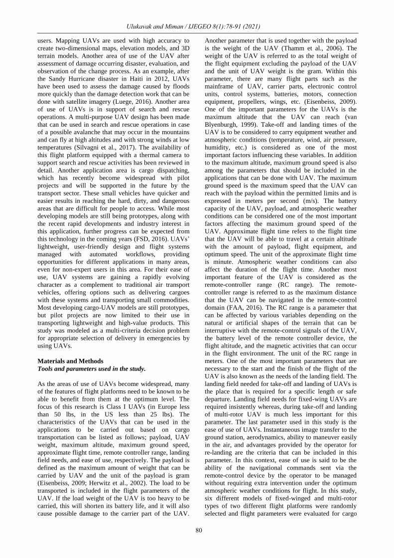
affect commercial competition. The specifications of the
fixed-wing and multi-rotor UAVs used in the study are
given in Table 1 and the images of the UAVs are given
in Figure 2.
Table 1. Parameters of UAV with fixed-wing and multi-rotor
Mo
del
Fli
gh
t
Pla
tfo
rm
Pa
ylo
ad
(gr)
UA
V W
eig
ht
(gr)
Ma
xim
um
Alt
itu
de
(met
er)
Ma
xim
um
Gro
un
d
Sp
eed
(m
/s)
Ap
pro
xim
ate
Fli
gh
t T
ime
(min
ute
)
Rem
ote
Co
ntr
oll
er
Ra
ng
e (m
eter
)
La
nd
ing
Fie
ld*
Ea
se o
f U
se
UAV_1 Fixed- Wing 1500 2000 250 20 60 2000 + Hard
UAV_2 Fixed- Wing 500 2500 200 18 60 2000 + Hard
UAV_3 Fixed- Wing 1000 2500 250 20 45 2000 + Hard
UAV_4 Multi-Rotor 3000 6000 250 36 30 2000 - Easy
UAV_5 Multi-Rotor 8000 5400 250 22 45 15000 - Easy
UAV_6 Multi-Rotor 5000 6000 250 17 45 4000 - Easy
*(+) necessary, (-) unnecessary
UAV_1 UAV_2 UAV_3
UAV_4 UAV_5 UAV_6
Figure 2. Alternative UAV vehicles for transportation
These alternatives were taken into consideration because
of their common usage and widespread availability in
markets rather than helicopters which do not appear
convenient vehicles for the site with limited accessibility
and have noticeably short time usage in air. Moreover,
quadrotors provide the great amount of safe flights due
to their available rotors.
Analytic Hierarchy Process
The most proper UAV selection for transportation in
emergency whose parameters provided above was
modeled as a multi-criteria decision making problem that
consists of qualitative and quantitative criteria and its
solution was pointed out through Analytic Hierarchy
Process (AHP), which is known to be one of the most
used techniques that incorporate with the decision-
maker’ opinion explicitly. Analytic hierarchy process
determines the alternatives’ relative standing on the ratio
scale basis and reflects the decision maker’s intuitive
comparisons with corresponding consistency in their
judgments (Al-Harbi, 2001). At each level in the
hierarchy, the decision-maker makes pairwise
comparisons for the elements at that level with regards to
preceding levels of criteria and synthesizes the
judgments through different levels to estimate each
alternative’s impact on the overall goal of the hierarchy
(Kablan, 2004). In the literature, AHP has been used
often with a broad range of applications as a multi-
criteria decision-making technique. Among its
applications, there are a variety of fields such as
determination of energy politics (Elkarmi et al., 1993),
project management (Enyinda, 2017), evaluation of
manufacturing technologies (Al-Ahmari, 2008),
selection of manufacturing process (Tiwari et al., 2001),
forming teams (Zakarian et al., 1999), selection of
marriage partner (Hajeeh et al., 2009), performance
management (Mizrahi, 2017) and health care systems
(Schmidt et al., 2015; Khorramı̇, et al., 2018).
Three basic steps of AHP can be summarized as i)
making pairwise judgments to obtain the comparison
matrix ii) determination of local weights aggregation of
which constitute to final weights of alternatives iii)
checking for consistency of comparisons at each level
and all-through the global hierarchy. Elements at a
particular level are compared pairwise with regard to

Ulukavak and Miman / IJEGEO 8(1):78-91 (2021)
82
immediate upper level as quantitative or qualitative
judgments to reflect the decision maker’s opinion in the
AHP (T L Saaty, 2006). This comparison is conducted
generally through a 9-point scale listed in Table 2
(Thomas L. Saaty, 1990).
Table 2. Basic comparison scale for pairwise judgments (Thomas L. Saaty, 1990)
Absolute Scale Definition Explanation
1 Equal importance Two activities contribute equally to the objective.
3 Moderate importance of one over
another
Experience and judgment slightly favor one activity over
another.
5 Essential or strong importance Experience and judgment strongly favor one activity over
another.
7 Very strong importance Activity is strongly favored, and its dominance is demonstrated
in practice.
9 Extreme importance The evidence favoring one activity over another is of the
highest possible order of affirmation.
2, 4, 6, 8 Intermediate values between two adjacent judgments
Reciprocals If activity i has one of the above numbers assigned to it when compared with activity j, then j has the
reciprocal value when compared with i.
AHP first determines the relative weights of criteria in a
top-down fashion and progresses towards alternatives by
computing priority weights of elements at each level
ending up the priority weights of alternatives through
aggregation bottom-up style at a time (Stam et al., 2003).
Saaty, (1988) presents priority weights associated with a
pairwise comparison matrix as a prime eigenvector and
normalizing the components of the prime eigenvector to
provide a unique solution. Let 𝐀 be an m×m comparison
matrix for m evaluation criteria and 𝑎𝑗𝑘 the entry of 𝐀
represents the relative importance of the jth
criterion with
respect to the kth criterion. Each of the �̅�𝑗𝑘 entry in the
normalized pairwise comparison matrix
𝐀𝑛𝑜𝑟𝑚 corresponds to the component in the jth
row and
kth
column and computed according to Eq. (1).
�̅�𝑗𝑘 =𝑎𝑗𝑘
∑ 𝑎𝑙𝑘𝑚𝑙=1
(1)
Each 𝑤𝑗 the entry of m-column criteria weights vector 𝒘
is obtained according to (2) by averaging all entries of
each row in 𝐀𝑛𝑜𝑟𝑚.
𝑤𝑗 =∑ �̅�𝑗𝑘
𝑚𝑘=1
𝑚(2)
After preference information corresponding comparison
matrices at each level is obtained locally, this
information is aggregated layer by layer in a bottom-up
fashion to obtain global priority weights (scores) of
alternatives in consideration. In a multicriteria decision
making problem with n alternatives and, m criteria
(options), let 𝐒 be an n×m choice score matrix. The 𝑠𝑖𝑗
the entry of 𝐒 is a component that shows ith choice
(alternative)’ score with respect jth
criterion. Assume
𝐁(𝑗) is an n×n pairwise comparison matrix of n choices
(alternatives) according to jth
criterion, the same two
steps procedure (first normalization, i.e. dividing of each
entry by the sum of entries in the corresponding column;
second obtaining the weight vector, i.e. averaging entries
of each row) applied to pairwise comparison matrix 𝐀 is
also applied to each 𝐁(𝑗) (𝑗 = 1, … , 𝑚) of m criteria, and
score vectors of 𝒔(𝑗) (𝑗 = 1, … , 𝑚) are obtained. The
score matrix 𝐒, is consisting of 𝒔(𝑗) corresponding to the
jth
column according to eq. (3) that shows the scores of
alternatives (choices) according to the jth
criterion.
𝐒 = [𝒔(1) … 𝒔(𝑚)] (3)
n-column global scores (priority weights) vector 𝒗 is
obtained through the multiplication of 𝐒 and 𝒘 according
to eq. (4). The ith
component of, 𝑣𝑖 , shows the global
score assigned to ith
alternative by the AHP.
𝒗 = 𝐒 . 𝒘 (4)
The ranking of alternatives (choices) is accomplished by
ordering them according to their global scores in a
descending scheme.
The consistency of the decision maker’s pairwise
comparative evaluations in each judgment (comparison)
matrix is checked by the AHP through consistency ratio
CR according to Eq. (5).
𝐶𝑅 =𝐶𝐼
𝑅𝐼(5)
𝐶𝐼 is the consistency index of an n×n judgment matrix
using its eigenvector 𝜆𝑚𝑎𝑥 through Eq. (6).
𝐶𝐼 =𝜆𝑚𝑎𝑥 − 𝑛
𝑛 − 1(6)
In practice, 𝜆𝑚𝑎𝑥 can be approximated by averaging
elements of the vector whose jth
component is the ratio of
the jth
element of 𝐀 . 𝒘 to the jth
element of 𝒘.
𝑅𝐼 is the random index where all entries of 𝐀 are random
and obtained averaging CIs corresponding to randomly
obtained pairwise judgment matrices, 𝐀s. 𝑅𝐼 values
reported and used by Lee (2017) according to Saaty and
Vargas (2000) and Saaty (2005) for 𝑛 ≤ 15 are tabulated
in Table 3.
83
Table 3. Random Indices (Saaty and Vargas, 2000, Saaty, 2005)
n 1 2 3 4 5 6 7 8 9 10 11 12 13 14 15
RI 0.00 0.00 0.58 0.90 1.12 1.24 1.32 1.41 1.45 1.49 1.51 1.54 1.56 1.57 1.58
The global consistency of hierarchical structure is
determined by the global consistency ratio CRH applied
to all through the hierarchy in a similar fashion (the ratio
of aggregated consistency index computed for overall
hierarchy, 𝑀 , to aggregated random index computed for
overall hierarchy, �̅� ). For a hierarchical structure with
three levels of 𝑀 and �̅� are computed through eq. (7)
and eq. (8) respectively as an illustration.
𝑀 = second level 𝐶𝐼 + |second − level
priority weightsvector
| × |third − level
𝐶𝐼svector
| (7)
�̅� = second level 𝑅𝐼 + |second − level
priority weightsvector
| × |third − level
𝑅𝐼svector
| (8)
𝐶𝑅𝐻 =𝑀
�̅�(9)
For each level at the hierarchy, the consistency of the
structure can be similarly computed bottom-up fashion.
For a global hierarchy as well as a single judgment
matrix, it is a common application to assume an
acceptable level of consistency for CR and CRH having
a value equal to or less than 0.1 (Schmidt et al., 2015).
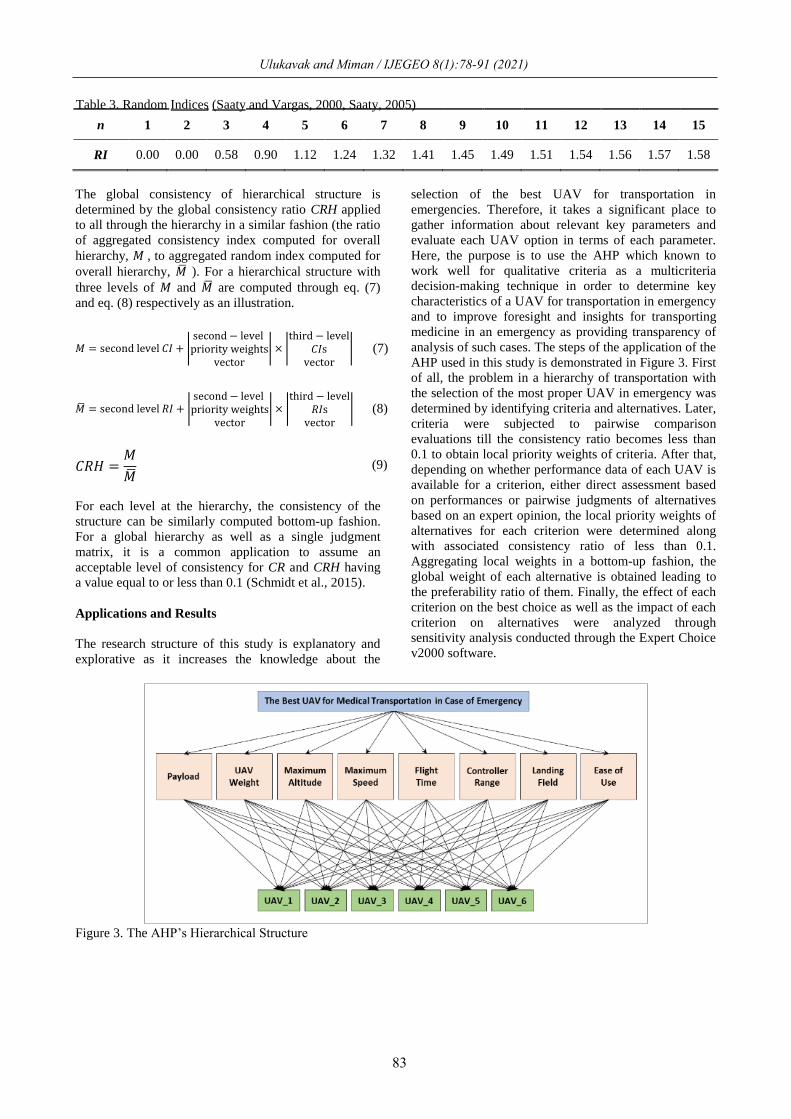
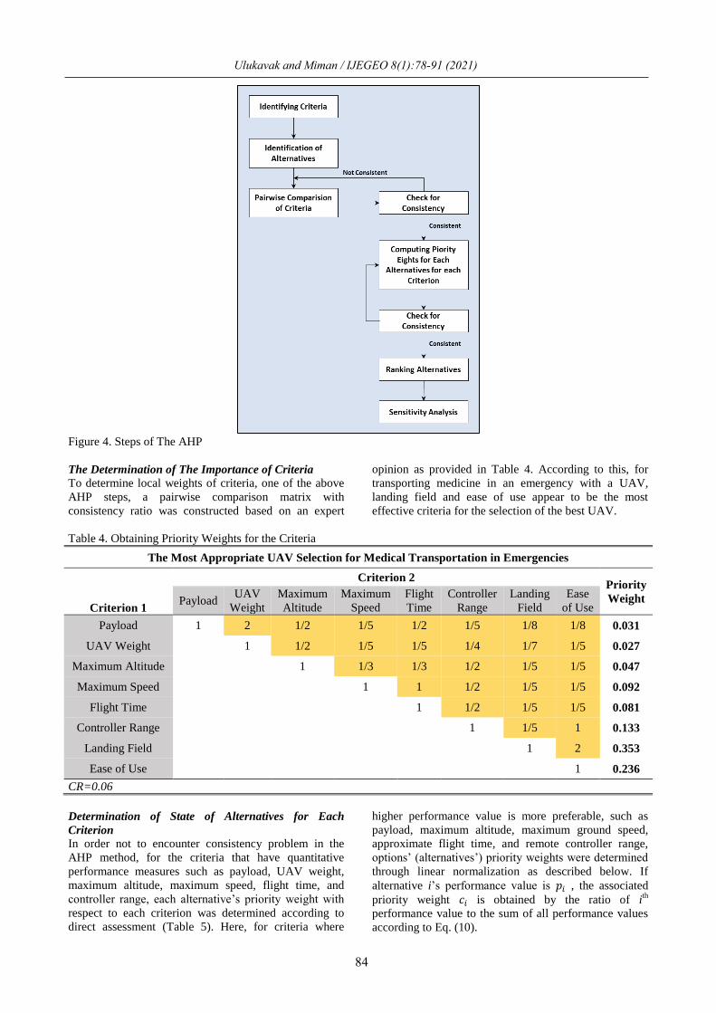
Applications and Results
The research structure of this study is explanatory and
explorative as it increases the knowledge about the
selection of the best UAV for transportation in
emergencies. Therefore, it takes a significant place to
gather information about relevant key parameters and
evaluate each UAV option in terms of each parameter.
Here, the purpose is to use the AHP which known to
work well for qualitative criteria as a multicriteria
decision-making technique in order to determine key
characteristics of a UAV for transportation in emergency
and to improve foresight and insights for transporting
medicine in an emergency as providing transparency of
analysis of such cases. The steps of the application of the
AHP used in this study is demonstrated in Figure 3. First
of all, the problem in a hierarchy of transportation with
the selection of the most proper UAV in emergency was
determined by identifying criteria and alternatives. Later,
criteria were subjected to pairwise comparison
evaluations till the consistency ratio becomes less than
0.1 to obtain local priority weights of criteria. After that,
depending on whether performance data of each UAV is
available for a criterion, either direct assessment based
on performances or pairwise judgments of alternatives
based on an expert opinion, the local priority weights of
alternatives for each criterion were determined along
with associated consistency ratio of less than 0.1.
Aggregating local weights in a bottom-up fashion, the
global weight of each alternative is obtained leading to
the preferability ratio of them. Finally, the effect of each
criterion on the best choice as well as the impact of each
criterion on alternatives were analyzed through
sensitivity analysis conducted through the Expert Choice
v2000 software.
Figure 3. The AHP’s Hierarchical Structure
Ulukavak and Miman / IJEGEO 8(1):78-91 (2021)
84
Figure 4. Steps of The AHP
The Determination of The Importance of Criteria
To determine local weights of criteria, one of the above
AHP steps, a pairwise comparison matrix with
consistency ratio was constructed based on an expert
opinion as provided in Table 4. According to this, for
transporting medicine in an emergency with a UAV,
landing field and ease of use appear to be the most
effective criteria for the selection of the best UAV.
Table 4. Obtaining Priority Weights for the Criteria
The Most Appropriate UAV Selection for Medical Transportation in Emergencies
Criterion 1
Criterion 2 Priority
Weight Payload UAV
Weight
Maximum
Altitude
Maximum
Speed
Flight
Time
Controller
Range
Landing
Field
Ease
of Use
Payload 1 2 1/2 1/5 1/2 1/5 1/8 1/8 0.031
UAV Weight 1 1/2 1/5 1/5 1/4 1/7 1/5 0.027
Maximum Altitude 1 1/3 1/3 1/2 1/5 1/5 0.047
Maximum Speed 1 1 1/2 1/5 1/5 0.092
Flight Time 1 1/2 1/5 1/5 0.081
Controller Range 1 1/5 1 0.133
Landing Field 1 2 0.353
Ease of Use 1 0.236
CR=0.06
Determination of State of Alternatives for Each
Criterion
In order not to encounter consistency problem in the
AHP method, for the criteria that have quantitative
performance measures such as payload, UAV weight,
maximum altitude, maximum speed, flight time, and
controller range, each alternative’s priority weight with
respect to each criterion was determined according to
direct assessment (Table 5). Here, for criteria where
higher performance value is more preferable, such as
payload, maximum altitude, maximum ground speed,
approximate flight time, and remote controller range,
options’ (alternatives’) priority weights were determined
through linear normalization as described below. If
alternative i’s performance value is 𝑝𝑖 , the associated
priority weight 𝑐𝑖 is obtained by the ratio of ith
performance value to the sum of all performance values
according to Eq. (10).
Ulukavak and Miman / IJEGEO 8(1):78-91 (2021)
Ulukavak and Miman / IJEGEO 8(1):78-91 (2021)
85
𝑐𝑖 =𝑝𝑖
∑ 𝑝𝑖𝑚𝑙=1
(10)
If the smaller performance value is more preferable for a
criterion such as (UAV weight), then normalization is
performed for 𝑝𝑖, values, that are intermediate
computational values obtained through the division of
the best performance value (the smallest value) by each
performance value, 𝑝𝑖 according to Eq. (11).
𝑝𝑖, =
min𝑖
{𝑝𝑖}
𝑝𝑖
(11)
The computational results of the above operations were
presented in Table 5 for the criteria of payload, UAV
weight, maximum altitude, maximum speed, flight time,
and controller range.
Table 5. Priority Weights of Alternatives for Criteria based on Performance Measures
Alternative
Priority Weights
Payload UAV
Weight
Maximum
Altitude
Maximum
Speed
Flight
Time
Controller
Range
UAV_1 0.0789 0.2749 0.1724 0.1504 0.2105 0.0741
UAV_2 0.0263 0.2200 0.1379 0.1353 0.2105 0.0741
UAV_3 0.0526 0.2200 0.1724 0.1504 0.1579 0.0741
UAV_4 0.1579 0.0916 0.1724 0.2707 0.1053 0.0741
UAV_5 0.4211 0.1018 0.1724 0.1654 0.1579 0.5556
UAV_6 0.2632 0.0916 0.1724 0.1278 0.1579 0.1481
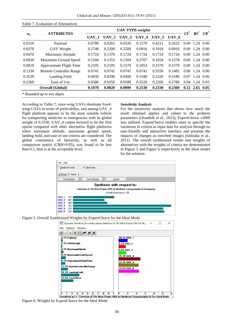
Priority weights for qualitative criteria such as landing
field and ease of use were obtained based on a pairwise
comparison matrix through an expert opinion with
corresponding consistency ratios and tabulated in Table
6. The local weights of criteria as well as local weights
of alternatives for each criterion along with global
weights of them through aggregation with corresponding
consistency ratio are presented in Table 7.
Table 6. Priority Weights of Alternatives for Criteria based on Pairwise Comparison Matrices
Comparison of Alternative according to Landing Field
Priority
Weight Alternative 1
Alternative 2
UAV_1 UAV_2 UAV_3 UAV_4 UAV_5 UAV_6
UAV_1 1 5 2 1/7 1/7 1/7 0.065
UAV_2 1 1/2 1/7 1/7 1/7 0.029
UAV_3 1 1/7 1/7 1/7 0.040
UAV_4 1 2 1 0.318
UAV_5 1 1/2 0.232
UAV_6 1 0.318
CR=0.06
Comparison of Alternative according to Ease of Use
Priority
Weight Alternative 1
Alternative 2
UAV_1 UAV_2 UAV_3 UAV_4 UAV_5 UAV_6
UAV_1 1 2 1 1/5 1/5 1/5 0.058
UAV_2 1 1/2 1/7 1/7 1/7 0.035
UAV_3 1 1/5 1/5 1/5 0.058
UAV_4 1 2 2 0.352
UAV_5 1 1/2 0.220
UAV_6 1 0.278
CR=0.03
Ulukavak and Miman / IJEGEO 8(1):78-91 (2021)
86
Table 7. Evaluation of Alternatives
wj ATTRIBUTES UAV TYPE-weights
CI* RI
* CR
*
UAV_1 UAV_2 UAV_3 UAV_4 UAV_5 UAV_6
0.0310 Payload 0.0789 0.0263 0.0526 0.1579 0.4211 0.2632 0.00 1.24 0.00
0.0270 UAV Weight 0.2749 0.2200 0.2200 0.0916 0.1018 0.0916 0.00 1.24 0.00
0.0470 Maximum Altitude 0.1724 0.1379 0.1724 0.1724 0.1724 0.1724 0.00 1.24 0.00
0.0920 Maximum Ground Speed 0.1504 0.1353 0.1504 0.2707 0.1654 0.1278 0.00 1.24 0.00
0.0810 Approximate Flight Time 0.2105 0.2105 0.1579 0.1053 0.1579 0.1579 0.00 1.24 0.00
0.1330 Remote Controller Range 0.0741 0.0741 0.0741 0.0741 0.5556 0.1481 0.00 1.24 0.00
0.3530 Landing Field 0.0650 0.0290 0.0400 0.3180 0.2320 0.3180 0.07 1.24 0.06
0.2360 Ease of Use 0.0580 0.0350 0.0580 0.3520 0.2200 0.2780 0.04 1.24 0.03
Overall (Global) 0.1070 0.0820 0.0890 0.2530 0.2330 0.2360 0.12 2.65 0.05
* Rounded up to two digits
According to Table 7, rotor-wing UAVs dominate fixed-
wing UAVs in terms of preferability, and among UAV_4
flight platform appears to be the most suitable vehicle
for transporting medicine in emergencies with its global
weight of 0.2530. UAV_4 comes forward to be the first
option compared with other alternative flight platforms
when maximum altitude, maximum ground speed,
landing field, and ease of use criteria are considered. The
global consistency of hierarchy, as well as all
comparison matrix (CRH=0.05), was found to be less
than 0.1, thus is at the acceptable level.
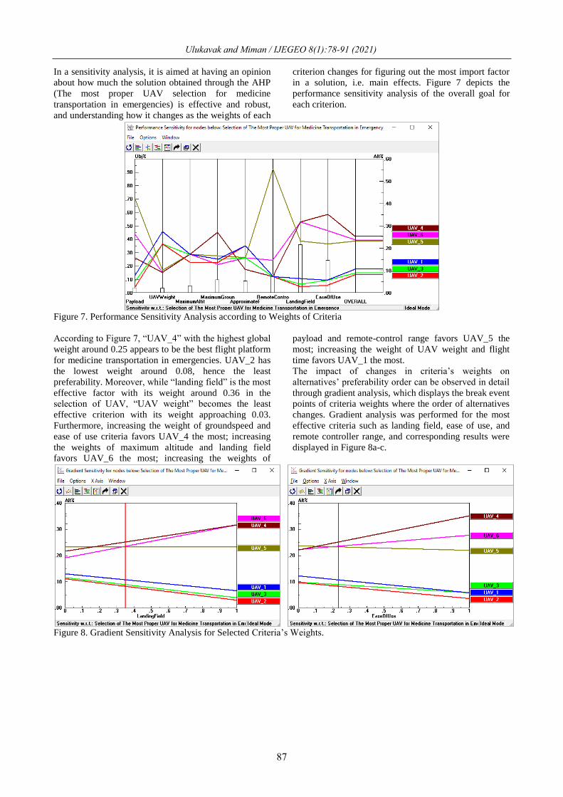
Sensitivity Analysis For the sensitivity analysis that shows how much the
result obtained applies and robust to the problem
parameters (Ossadnik et al., 2013), ExpertChoice v2000
was utilized. ExpertChoice enables users to specify the
variations in criteria as input data for analysis through its
user-friendly and interactive interface and presents the
impacts of changes as enriched images (Ishizaka et al.,
2011). The overall synthesized results and weights of
alternatives with the weights of criteria are demonstrated
in Figure 5 and Figure 6 respectively in the ideal model
for the solution.
Figure 5. Overall Synthesized Weights by ExpertChoice for the Ideal Mode
Figure 6. Weights by ExpertChoice for the Ideal Mode
87
In a sensitivity analysis, it is aimed at having an opinion
about how much the solution obtained through the AHP
(The most proper UAV selection for medicine
transportation in emergencies) is effective and robust,
and understanding how it changes as the weights of each
criterion changes for figuring out the most import factor
in a solution, i.e. main effects. Figure 7 depicts the
performance sensitivity analysis of the overall goal for
each criterion.
Figure 7. Performance Sensitivity Analysis according to Weights of Criteria
According to Figure 7, “UAV_4” with the highest global
weight around 0.25 appears to be the best flight platform
for medicine transportation in emergencies. UAV_2 has
the lowest weight around 0.08, hence the least
preferability. Moreover, while “landing field” is the most
effective factor with its weight around 0.36 in the
selection of UAV, “UAV weight” becomes the least
effective criterion with its weight approaching 0.03.
Furthermore, increasing the weight of groundspeed and
ease of use criteria favors UAV_4 the most; increasing
the weights of maximum altitude and landing field
favors UAV_6 the most; increasing the weights of
payload and remote-control range favors UAV_5 the
most; increasing the weight of UAV weight and flight
time favors UAV_1 the most.
The impact of changes in criteria’s weights on
alternatives’ preferability order can be observed in detail
through gradient analysis, which displays the break event
points of criteria weights where the order of alternatives
changes. Gradient analysis was performed for the most
effective criteria such as landing field, ease of use, and
remote controller range, and corresponding results were
displayed in Figure 8a-c.
Figure 8. Gradient Sensitivity Analysis for Selected Criteria’s Weights.
Ulukavak and Miman / IJEGEO 8(1):78-91 (2021)
Ulukavak and Miman / IJEGEO 8(1):78-91 (2021)
88
Figure 8. Cont.
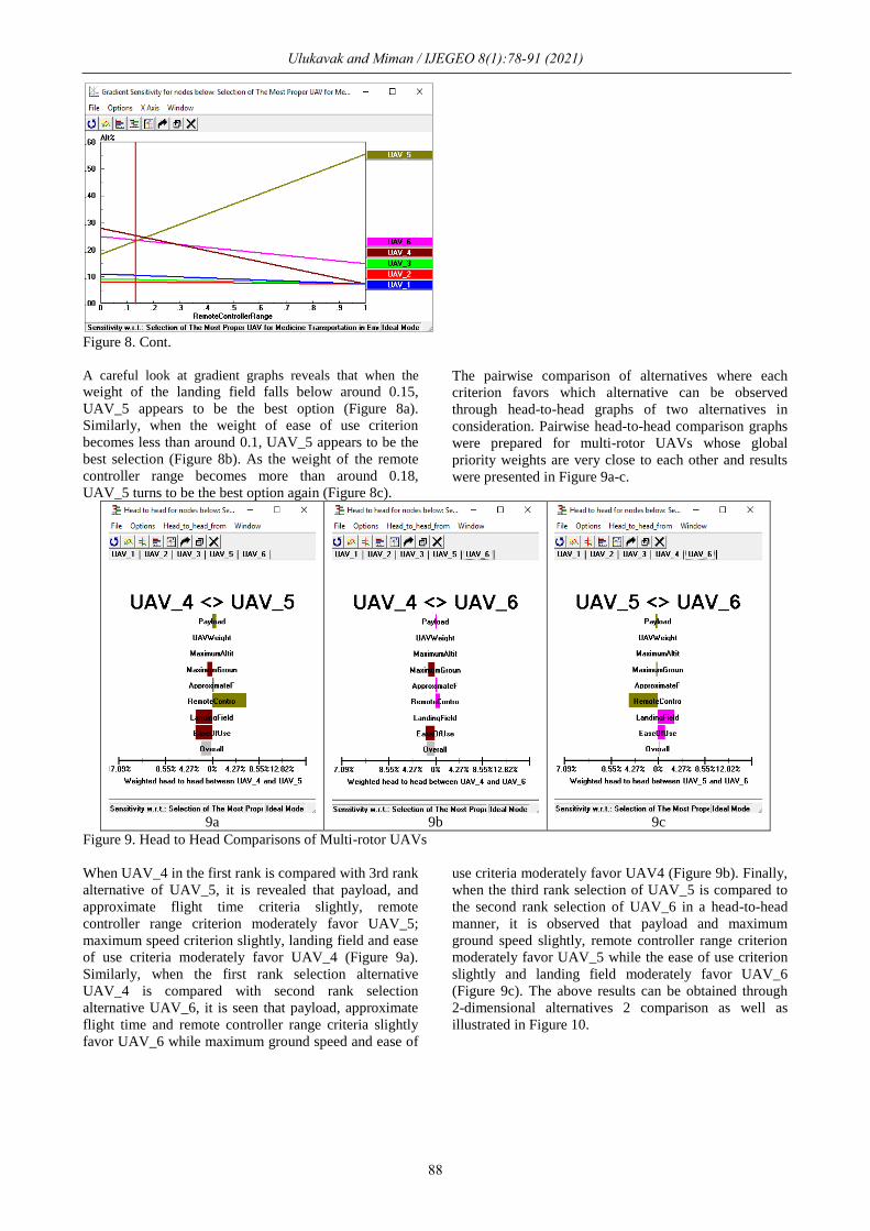
A careful look at gradient graphs reveals that when the
weight of the landing field falls below around 0.15,
UAV_5 appears to be the best option (Figure 8a).
Similarly, when the weight of ease of use criterion
becomes less than around 0.1, UAV_5 appears to be the
best selection (Figure 8b). As the weight of the remote
controller range becomes more than around 0.18,
UAV_5 turns to be the best option again (Figure 8c).
The pairwise comparison of alternatives where each
criterion favors which alternative can be observed
through head-to-head graphs of two alternatives in
consideration. Pairwise head-to-head comparison graphs
were prepared for multi-rotor UAVs whose global
priority weights are very close to each other and results
were presented in Figure 9a-c.
9a 9b 9c
Figure 9. Head to Head Comparisons of Multi-rotor UAVs
When UAV_4 in the first rank is compared with 3rd rank
alternative of UAV_5, it is revealed that payload, and
approximate flight time criteria slightly, remote
controller range criterion moderately favor UAV_5;
maximum speed criterion slightly, landing field and ease
of use criteria moderately favor UAV_4 (Figure 9a).
Similarly, when the first rank selection alternative
UAV_4 is compared with second rank selection
alternative UAV_6, it is seen that payload, approximate
flight time and remote controller range criteria slightly
favor UAV_6 while maximum ground speed and ease of
use criteria moderately favor UAV4 (Figure 9b). Finally,
when the third rank selection of UAV_5 is compared to
the second rank selection of UAV_6 in a head-to-head
manner, it is observed that payload and maximum
ground speed slightly, remote controller range criterion
moderately favor UAV_5 while the ease of use criterion
slightly and landing field moderately favor UAV_6
(Figure 9c). The above results can be obtained through
2-dimensional alternatives 2 comparison as well as
illustrated in Figure 10.
89
Figure 10. Two-Dimensional Analysis of Alternatives with respect to the Landing Field and the Ease of Use Criteria
As intuitively expected, the analysis of alternatives with
respect to the landing field and ease of use criteria
indicates that multi-rotor UAVs (UAV_4, UAV_5,
UAV_6) dominate fixed-wing UAVs (UAV_1, UAV_2,
UAV3). This is revealed from the 2-dimensional graph
as multi-rotor alternatives located in top-right (first
quarter) while fixed-wing alternatives are located in the
left bottom (third quarter) on the graph constructed.
Discussion and Conclusion
In order to evaluate flight platforms, comparable
performance indicators, and tests in more regions are
required. In order to realize the use of UAVs in cargo
transportation, statistics about the flights to be performed
in the test areas, daily logs of the actual flights, climate
information, failure rates, and other performance
measurements of the flight platforms are needed. While
most of the developing models are still in prototypes,
along with the rapid developments experienced in recent
years and the interest of the industry in this application,
further progress can be expected in the coming years.
The analytical hierarchy method used in this study takes
into consideration not only quantitative data but also
qualitative evaluation by experts in a novel way of
dealing with the multi-criteria decision making of UAV
selection problem. The sensitivity analysis conducted
reveals how robust the final decision AHP provided. By
this approach, one can easily adapt a decision of
selection of proper UAVs depending on each criterion
weight (i.e. importance).
The surveys in this area will gain beneficial results in
satisfactory levels with multi-disciplinary practices that
many disciplines will achieve. This study can be
regarded as a pioneer to exploit the use of UAVs in a
variety of settings one of which is emerging events.
Especially the methodology used (AHP) illustrates how
expert opinion can be directly included in multi-criteria
decision making related to UAVs. It also provides bases
to improve the capabilities of UAVs to achieve a set of
dedicated missions.
Acknowledgments
No grants have been received in this project. In this
study, the authors used their own resources.
References
Al-Ahmari, A. M. A. (2008). A methodology for
selection and evaluation of advanced manufacturing
technologies. International Journal of Computer
Integrated Manufacturing. doi:
10.1080/09511920701678825
Al-Harbi, K. M. A. S. (2001). Application of the AHP in
project management. International Journal of Project
Management. doi: 10.1016/S0263-7863(99)00038-1
Bayırhan, İ., Gazioğlu, C. (2019). Use of Unmanned
Aerial Vehicles (UAV) And Marine Environment
Simulator in Oil Pollution Investigations,
International Symposium on Applied Geoinformatics
(ISAG-2019), Istanbul, TÜRKIYE, 7-9 Nov 2019, 1-
6.
Bayırhan, İ., Gazioğlu, C. (2019). Use of Unmanned
Aerial Vehicles (UAV) And Marine Environment
Simulator in Oil Pollution Investigations, Baltic J.
Modern Computing, 8, 327-336.
Clarke, R. (2014). Understanding the drone epidemic.
Computer Law and Security Review. doi:
10.1016/j.clsr.2014.03.002
Colomina, I., Molina, P. (2014). Unmanned aerial
systems for photogrammetry and remote sensing: A
review. In ISPRS Journal of Photogrammetry and
Ulukavak and Miman / IJEGEO 8(1):78-91 (2021)
Ulukavak and Miman / IJEGEO 8(1):78-91 (2021)
90
Remote Sensing. doi: 10.1016/j.isprsjprs.2014.02.013
Eisenbeiss, H. (2009). UAV Photogrammetry. Swiss
Federal Institute of Technology Zurich.
Elkarmi, F., Mustafa, I. (1993). Increasing the utilization
of solar energy technologies (SET) in Jordan.
Analytic hierarchy process. Energy Policy. doi:
10.1016/0301-4215(93)90186-J
Enyinda, C. I. (2017). Quantitative Risk Analysis for
International Project Management and Programs in
an Emerging Economy. R. Benlamri & M. Sparer
(Eds.), Leadership, Innovation and Entrepreneurship
as Driving Forces of the Global Economy (pp. 769–
780). Cham: Springer International Publishing.
Erenoglu, R., Erenoglu, O. (2018). A case study on the
comparison of terrestrial methods and unmanned
aerial vehicle technique in landslide surveys:
Sarıcaeli landslide, Çanakkale, NW Turkey,
International Journal of Environment and
Geoinformatics, 5(3), 325-336, doi:
10.30897/ijegeo.468061.
FAA. (2016). United States Department of
Transportation Federal Aviation Administration
(FAA) Hand Book.
FSD. (2016). Drone in Humanitarian Action: A Guide to
the Use of Airborne Systems in Humanitarian Crises.
Swiss Foundation for Mine Action (FSD).
Hajeeh, M., Lairi, S. (2009). Marriage partner selection
in Kuwait: An analytical hierarchy process approach.
Journal of Mathematical Sociology. doi:
10.1080/00222500902953620
Hansen, R. L. (2016). Traffic monitoring using UAV
Technology. American Surveyor.
Herwitz, S. R., Leung, J. G., Higgins, R. G., Dunagan, S.
E. (2002). Remote command-and-control of imaging
payloads using commercial off-the-shelf technology.
IEEE International Geoscience and Remote Sensing
Symposium, 5, 2726–2728 vol.5. doi:
10.1109/IGARSS.2002.1026755
Ishizaka, A., Labib, A. (2011). Review of the main
developments in the analytic hierarchy process. In
Expert Systems with Applications. doi:
10.1016/j.eswa.2011.04.143
Kablan, M. M. (2004). Decision support for energy
conservation promotion: An analytic hierarchy
process approach. Energy Policy. doi:
10.1016/S0301-4215(03)00078-8
Karataş, K., Altınışık, N. (2020). The Effect of UAV
Usage on Detail Points in Cadastre Update Studies:
Çorum-Karaköy Case Study. International Journal of
Environment and Geoinformatics, 7(2), 140-146.
doi.10.30897/ijegeo.646155.
Khorramı̇, B., Valı̇zadeh Kamran, K., Roostaei, S.
(2018). Assessment of Groundwater-Level
Susceptibility to Degradation Based on Analytical
Network Process (ANP). International Journal of
Environment and Geoinformatics, 5(3), 314-324. doi.
10.30897/ijegeo.451067.
LEE, H. S. (2017). Priority Analysis of Subscription
Attributes for High-Speed Internet Service:
Application of AHP Technique. Journal of Internet
Banking and Commerce, 22(1), 1–18.
Luege, T. (2016). Mapping Rapid Damage Assessments
of Tabarre and Surrounding Communities in Haiti
following Hurricane Sandy.
Mizrahi, S. (2017). A Framework for Strategic
Performance Management for the Public Sector
Using the Analytic Hierarchy Process. In Public
Policy and Performance Management in Democratic
Systems (pp. 99–126). Springer.
Ossadnik, W., Kaspar, R. (2013). Evaluation of AHP
software from a management accounting perspective.
Journal of Modelling in Management. doi:
10.1108/JM2-01-2011-0007
Saaty, T.L., Vargas, L. (2000). Fundamentals of
Decision Making and Priority Theory With the
Analytic Hierarchy Process. RWS Publications.
Saaty, T L. (2006). Rank from comparisons and from
ratings in the analytic hierarchy/network processes.
European Journal of Operational Research, 168(2),
557–570.
Saaty, Thomas L. (1988). The Analytic Hierarchy
Process (Revised ed). Pittsburgh: The University of
Pitssburgh.
Saaty, Thomas L. (1990). How to make a decision: The
analytic hierarchy process. European Journal of
Operational Research. doi: 10.1016/0377-
2217(90)90057-I
Saaty, Thomas L. (2005). Theory and applications of
analytic network process: decision making with
benefits, opportunities, costs, and risks. Pittsburg:
RWS Publications.
Schmidt, K., Aumann, I., Hollander, I., Damm, K., Von
Der Schulenburg, J. M. G. (2015). Applying the
Analytic Hierarchy Process in healthcare research: A
systematic literature review and evaluation of
reporting. In BMC Medical Informatics and Decision
Making. doi: 10.1186/s12911-015-0234-7
Segui-Gasco, P., Al-Rihani, Y., Shin, H. S., Savvaris, A.
(2014). A novel actuation concept for a multi rotor
UAV. Journal of Intelligent and Robotic Systems:
Theory and Applications. doi: 10.1007/s10846-013-
9987-3
Silvagni, M., Tonoli, A., Zenerino, E., Chiaberge, M.
(2017). Multipurpose UAV for search and rescue
operations in mountain avalanche events. In
Geomatics, Natural Hazards and Risk. doi:
10.1080/19475705.2016.1238852
Stam, A., Duarte Silva, A. P. (2003). On multiplicative
priority rating methods for the AHP. European
Journal of Operational Research. doi:
10.1016/S0377-2217(02)00228-X
Thamm, H. P., Judex, M. (2006). The “low-cost drone”-
an interesting tool for process monitoring in a high
spatial and temporal resolution. ISPRS Mid-Term
Symposium, 8–11.
Tiwari, M. K., Banerjee, R. (2001). A decision support
system for the selection of a casting process using
analytic hierarchy process. Production Planning &
Control, 12(7), 689–694. doi:
10.1080/09537280010016783
Utlu, M., Öztürk, M., Şı̇mşek, M. (2020). Rockfall
Analysis Based on UAV Technology in Kazıklıali
Gorge, Aladağlar (Taurus Mountains, Turkey).
International Journal of Environment and
Geoinformatics, 7(3), 239-251.doi.
10.30897/ijegeo.740963.

Ulukavak and Miman / IJEGEO 8(1):78-91 (2021)
91
van Blyenburgh, P. (1999). UAVs: an overview. Air &
Space Europe. doi: 10.1016/S1290-0958(00)88869-3
Waharte, S., Trigoni, N. (2010). Supporting search and
rescue operations with UAVs. Proceedings - EST
2010 - 2010 International Conference on Emerging
Security Technologies, ROBOSEC 2010 - Robots and
Security, LAB-RS 2010 - Learning and Adaptive
Behavior in Robotic Systems. doi:
10.1109/EST.2010.31
Zakarian, A., Kusiak, A. (1999). Forming teams: an
analytical approach. IIE Transactions (Institute of
Industrial Engineers). doi:
10.1080/07408179908969808.


![[Article] Unmanned aerial vehicle remotely sensed datasets, a …geodata.kr/assets/pdf/7/journal-1-1-38.pdf · generated using rotary-wing UAV(unmanned aerial vehicle) system for](https://img.pdfslide.tips/doc/110x75/5e99aef244dfab24c12e8cfc/article-unmanned-aerial-vehicle-remotely-sensed-datasets-a-generated-using-rotary-wing.jpg)