Embed Size (px)
Citation preview
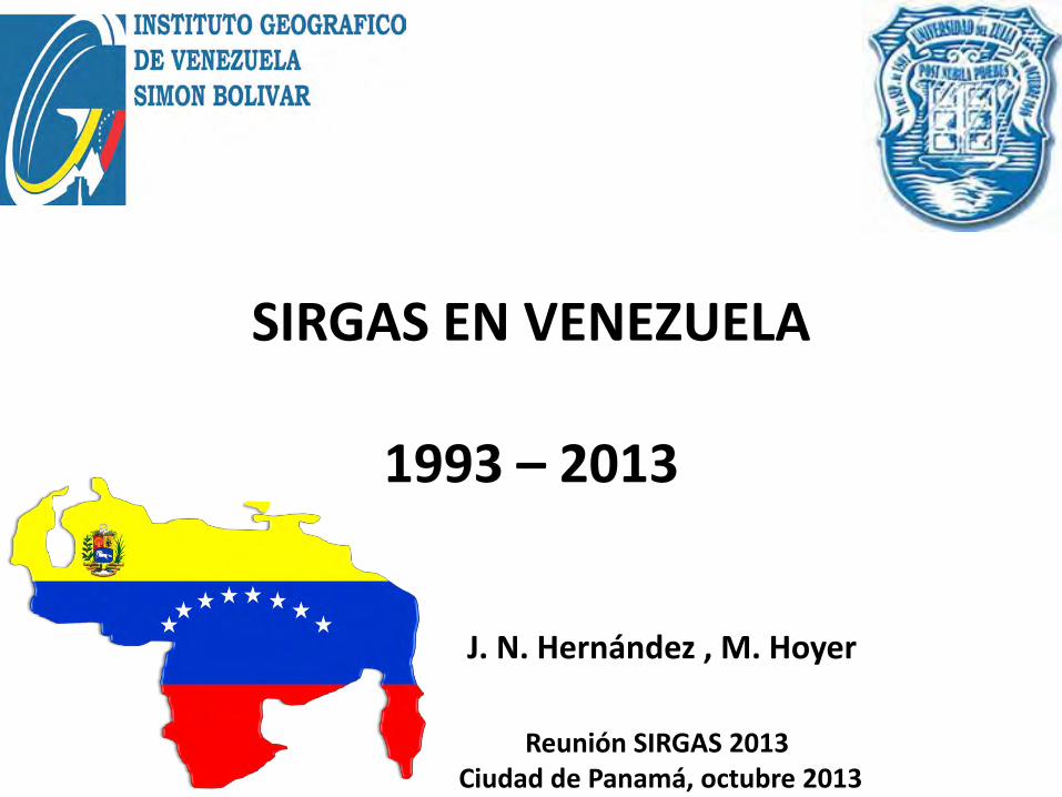
SIRGAS EN VENEZUELA
1993 – 2013
J. N. Hernández , M. Hoyer
Reunión SIRGAS 2013 Ciudad de Panamá, octubre 2013
OBJETIVO DE LA PRESENTACIÓN
Resumir, con motivo del vigésimo aniversario de SIRGAS, la activa participación de Venezuela en este proyecto durante los 20 años de vigencia de esta iniciativa continental.
INTRODUCCIÓN
FUNDAMENTO LEGAL
Ley de Geografía, Cartografía y Catastro Nacional. Art. 11.- Vinculación al Sistema Geodésico Nacional. Art. 45.- El IGVSB como organismo rector. Art. 46.- Dirigir, coordinar políticas nacionales en geodesia…..
INSTITUCIONES VENEZOLANAS ACTIVAS EN SIRGAS
La participación de Venezuela en el proyecto SIRGAS ha sido
principalmente un trabajo conjunto entre el Instituto Geográfico de Venezuela (IGVSB) y el Laboratorio de Geodesia Física y Satelital de la Universidad del Zulia (LGFS-LUZ).
Ocasionalmente han asistido representantes de la Dirección de
Geografía y Cartografía de las Fuerzas Armadas (DIGECAFA), PDVSA y otras dependencias públicas y privadas.
PERSONAL VINCULADO A ESTA
REPRESENTACIÓN
Al inicio • José Napoleón Hernández IGVSB • José Briceño DIGECAFA • Melvin Hoyer LUZ
Más recientemente • Victor Cioce LUZ
Otros participantes de las instituciones antes
mencionadas y de otras dependencias publicas y privadas ( ej. PDVSA, MECINCA)
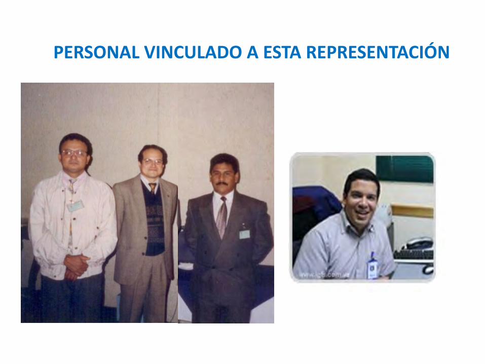
PERSONAL VINCULADO A ESTA REPRESENTACIÓN
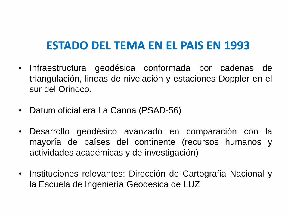
ESTADO DEL TEMA EN EL PAIS EN 1993 • Infraestructura geodésica conformada por cadenas de
triangulación, lineas de nivelación y estaciones Doppler en el sur del Orinoco.
• Datum oficial era La Canoa (PSAD-56)
• Desarrollo geodésico avanzado en comparación con la mayoría de países del continente (recursos humanos y actividades académicas y de investigación)
• Instituciones relevantes: Dirección de Cartografia Nacional y la Escuela de Ingeniería Geodesica de LUZ
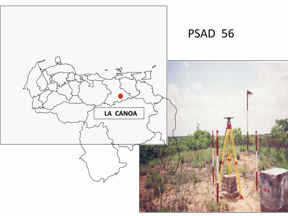
LA CANOA
PSAD 56
ACTIVIDADES MAS IMPORTANTES EJECUTADAS DENTRO DEL PROYECTO SIRGAS
1993 – 2013 • Coordinación del WGI (Sistema de Referencia) durante la fase inicial del proyecto.
• Las campañas de observación GPS para el establecimiento de REGVEN simultáneas con las campañas SIRGAS de 1995 y 2000.
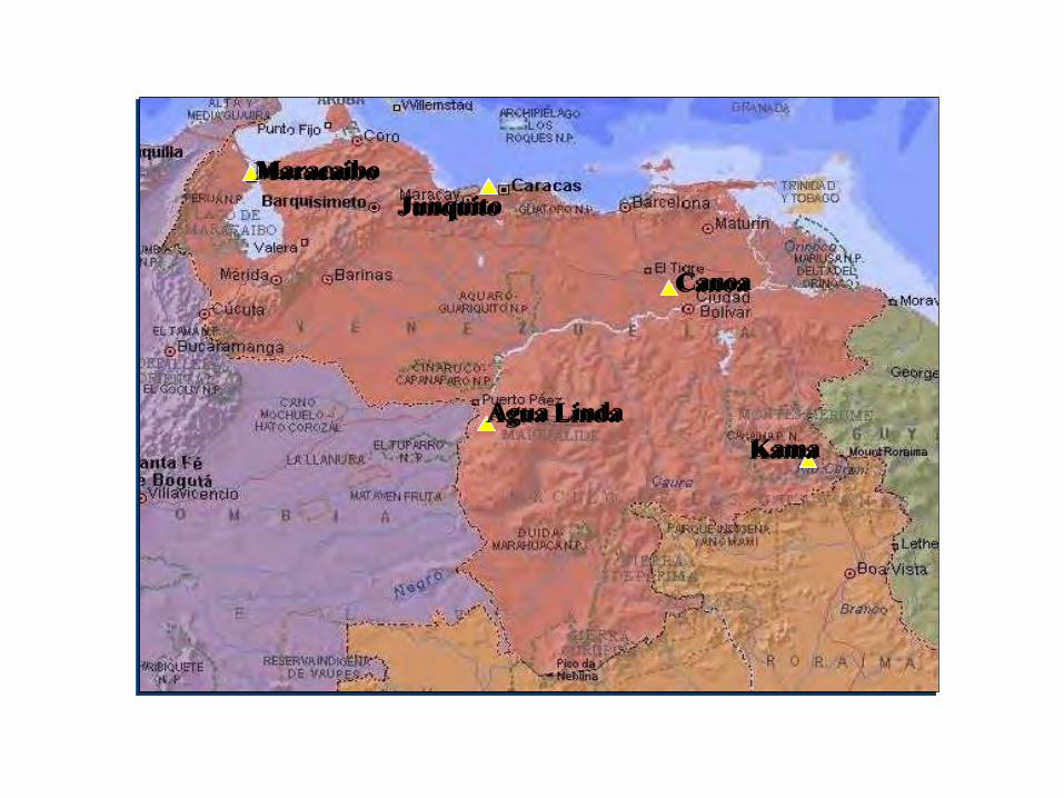
Kama
Junquito
Agua Linda
Canoa
Maracaibo
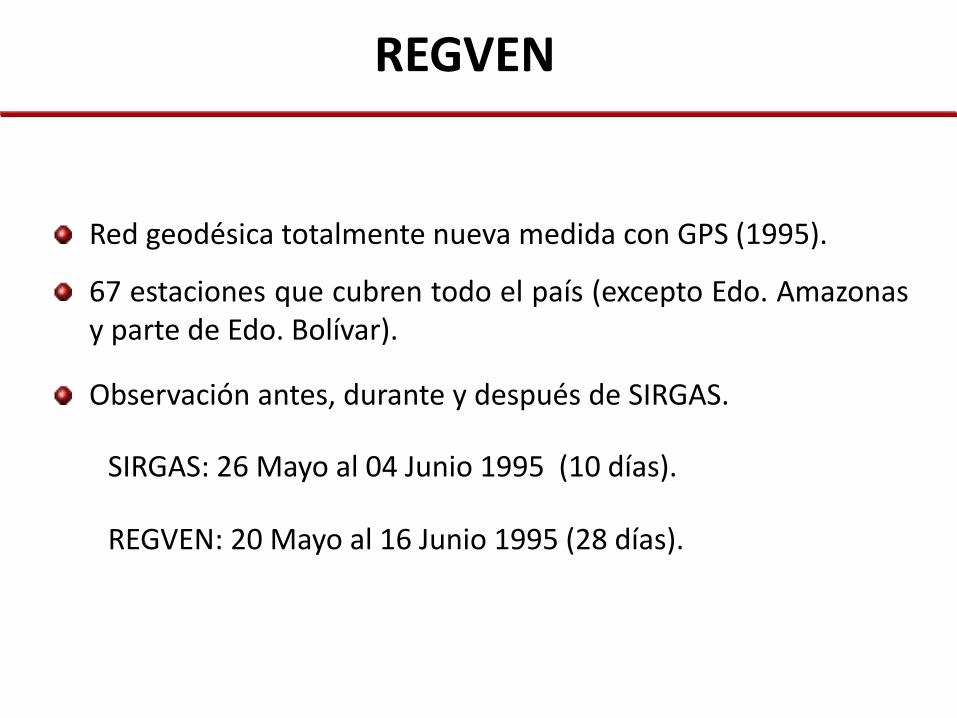
REGVEN
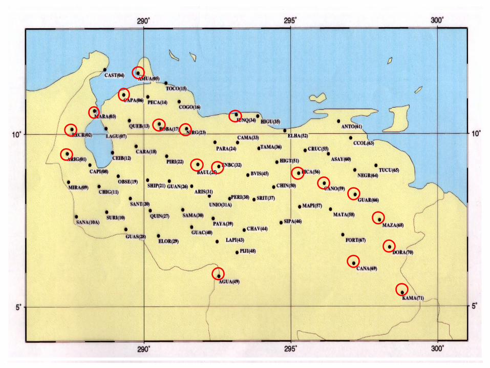
Red geodésica totalmente nueva medida con GPS (1995).
67 estaciones que cubren todo el país (excepto Edo. Amazonas y parte de Edo. Bolívar).
Observación antes, durante y después de SIRGAS.
SIRGAS: 26 Mayo al 04 Junio 1995 (10 días).
REGVEN: 20 Mayo al 16 Junio 1995 (28 días).
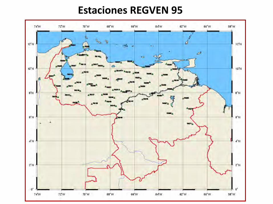
Estaciones REGVEN 95
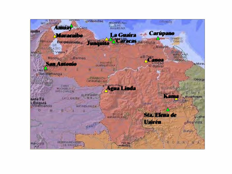
Kama
Junquito
Agua Linda
Canoa
Maracaibo
San Antonio
Carúpano
Sta. Elena de Uairén
La Guaira Caracas
Amuay
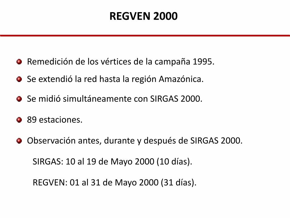
REGVEN 2000
Remedición de los vértices de la campaña 1995.
Se extendió la red hasta la región Amazónica.
Se midió simultáneamente con SIRGAS 2000.
89 estaciones.
Observación antes, durante y después de SIRGAS 2000.
SIRGAS: 10 al 19 de Mayo 2000 (10 días).
REGVEN: 01 al 31 de Mayo 2000 (31 días).
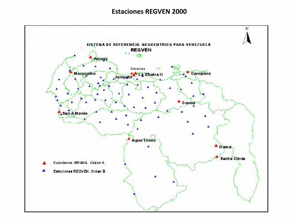
Estaciones REGVEN 2000
Caracas
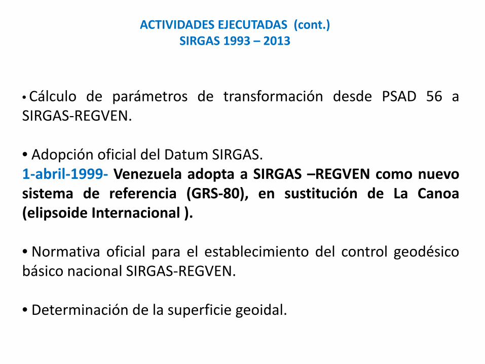
• Cálculo de parámetros de transformación desde PSAD 56 a SIRGAS-REGVEN. • Adopción oficial del Datum SIRGAS. 1-abril-1999- Venezuela adopta a SIRGAS –REGVEN como nuevo sistema de referencia (GRS-80), en sustitución de La Canoa (elipsoide Internacional ). • Normativa oficial para el establecimiento del control geodésico básico nacional SIRGAS-REGVEN.
• Determinación de la superficie geoidal.
ACTIVIDADES EJECUTADAS (cont.) SIRGAS 1993 – 2013
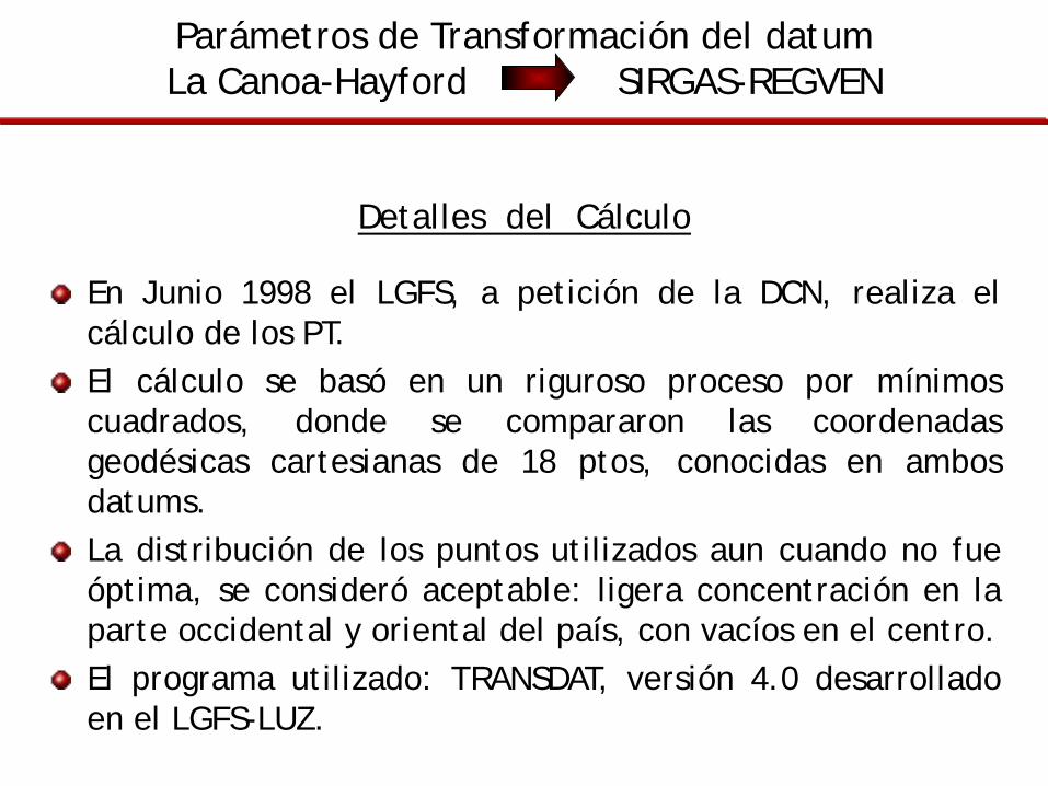
Parámetros de Transformación del datum La Canoa-Hayford SIRGAS-REGVEN
Detalles del Cálculo
En Junio 1998 el LGFS, a petición de la DCN, realiza el cálculo de los PT. El cálculo se basó en un riguroso proceso por mínimos cuadrados, donde se compararon las coordenadas geodésicas cartesianas de 18 ptos, conocidas en ambos datums. La distribución de los puntos utilizados aun cuando no fue óptima, se consideró aceptable: ligera concentración en la parte occidental y oriental del país, con vacíos en el centro. El programa utilizado: TRANSDAT, versión 4.0 desarrollado en el LGFS-LUZ.
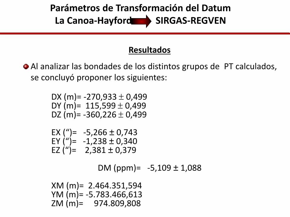
Parámetros de Transformación del Datum La Canoa-Hayford SIRGAS-REGVEN
Resultados
Al analizar las bondades de los distintos grupos de PT calculados, se concluyó proponer los siguientes:
DX (m)= -270,933 ± 0,499 DY (m)= 115,599 ± 0,499 DZ (m)= -360,226 ± 0,499 EX (“)= -5,266 ± 0,743 EY (“)= -1,238 ± 0,340 EZ (“)= 2,381 ± 0,379
DM (ppm)= -5,109 ± 1,088 XM (m)= 2.464.351,594 YM (m)= -5.783.466,613 ZM (m)= 974.809,808
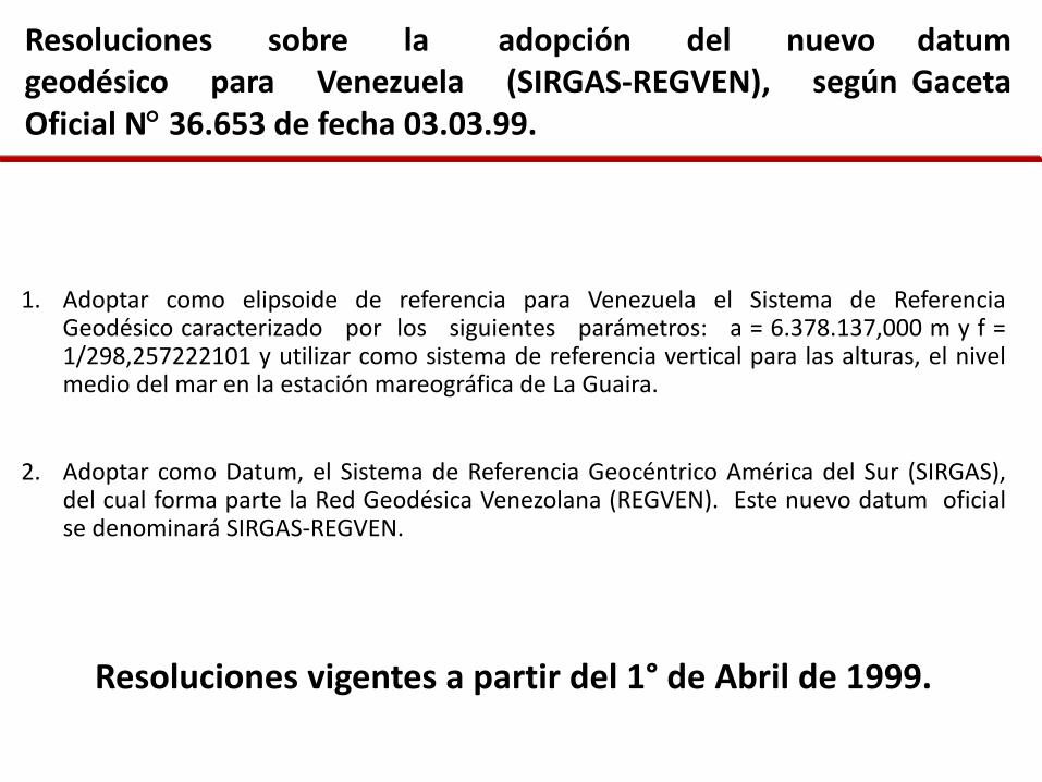
Resoluciones sobre la adopción del nuevo datum geodésico para Venezuela (SIRGAS-REGVEN), según Gaceta Oficial N° 36.653 de fecha 03.03.99.
1. Adoptar como elipsoide de referencia para Venezuela el Sistema de Referencia Geodésico caracterizado por los siguientes parámetros: a = 6.378.137,000 m y f = 1/298,257222101 y utilizar como sistema de referencia vertical para las alturas, el nivel medio del mar en la estación mareográfica de La Guaira.
2. Adoptar como Datum, el Sistema de Referencia Geocéntrico América del Sur (SIRGAS), del cual forma parte la Red Geodésica Venezolana (REGVEN). Este nuevo datum oficial se denominará SIRGAS-REGVEN.
Resoluciones vigentes a partir del 1° de Abril de 1999.
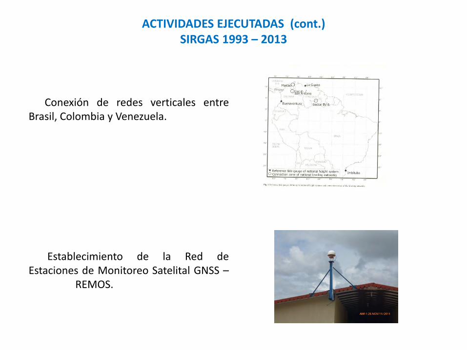
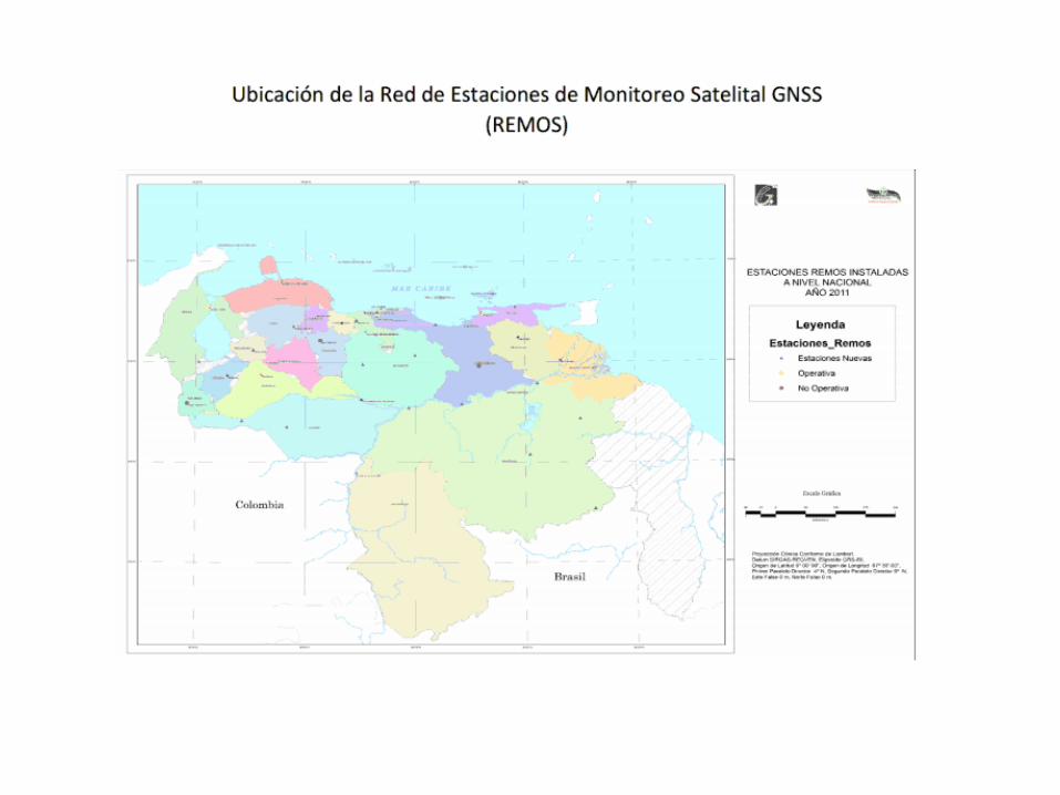
Conexión de redes verticales entre Brasil, Colombia y Venezuela. Establecimiento de la Red de Estaciones de Monitoreo Satelital GNSS – REMOS.
ACTIVIDADES EJECUTADAS (cont.) SIRGAS 1993 – 2013
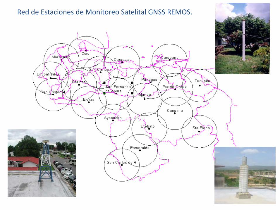
Red de Estaciones de Monitoreo Satelital GNSS REMOS.
• Instalación del Centro de Procesamiento en el LGFS- LUZ.
• Coordinación del grupo de GNSS en Tiempo Real (2008 – 2011)
ACTIVIDADES EJECUTADAS (Cont.) SIRGAS 1993 – 2013

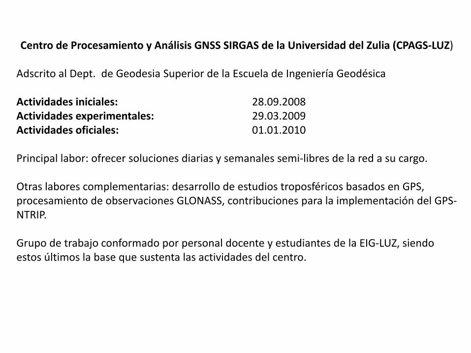
Centro de Procesamiento y Análisis GNSS SIRGAS de la Universidad del Zulia (CPAGS-LUZ) Adscrito al Dept. de Geodesia Superior de la Escuela de Ingeniería Geodésica Actividades iniciales: 28.09.2008 Actividades experimentales: 29.03.2009 Actividades oficiales: 01.01.2010 Principal labor: ofrecer soluciones diarias y semanales semi-libres de la red a su cargo. Otras labores complementarias: desarrollo de estudios troposféricos basados en GPS, procesamiento de observaciones GLONASS, contribuciones para la implementación del GPS-NTRIP. Grupo de trabajo conformado por personal docente y estudiantes de la EIG-LUZ, siendo estos últimos la base que sustenta las actividades del centro.
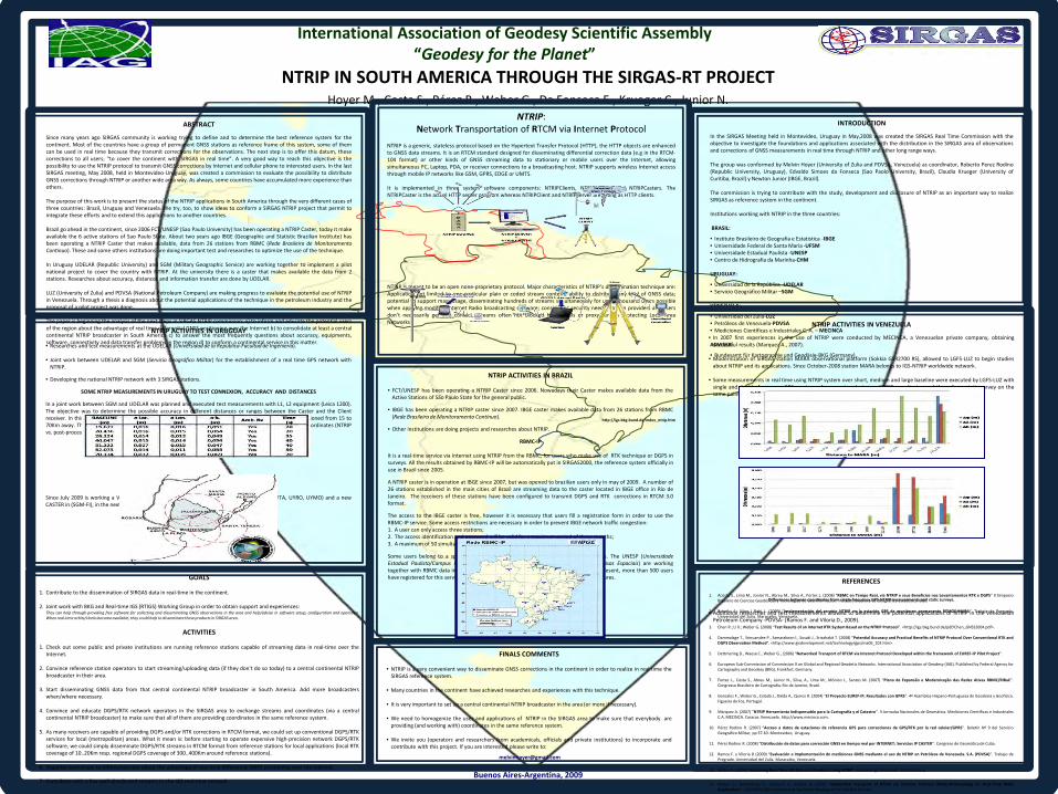
NTRIP IN SOUTH AMERICA THROUGH THE SIRGAS-RT PROJECT
Hoyer M., Costa S., Pérez R., Weber G., Da Fonseca E., Krueger C., Junior N.
International Association of Geodesy Scientific Assembly “Geodesy for the Planet”
Buenos Aires-Argentina, 2009
GOALS 1. Contribute to the dissemination of SIRGAS data in real-time in the continent.
2. Joint work with BKG and Real-time IGS (RTIGS) Working Group in order to obtain support and experiences:
They can help through providing free software for collecting and disseminating GNSS observations in the area and help/advise in software setup, configuration and operation. When real-time orbits/clocks become available, they could help to disseminate these products in SIRGAS area.
ACTIVITIES
1. Check out some public and private institutions are running reference stations capable of streaming data in real-time over the
Internet.
2. Convince reference station operators to start streaming/uploading data (if they don't do so today) to a central continental NTRIP broadcaster in their area.
3. Start disseminating GNSS data from that central continental NTRIP broadcaster in South America. Add more broadcasters when/where necessary.
4. Convince and educate DGPS/RTK network operators in the SIRGAS area to exchange streams and coordinates (via a central continental NTRIP broadcaster) to make sure that all of them are providing coordinates in the same reference system.
5. As many receivers are capable of providing DGPS and/or RTK corrections in RTCM format, we could set up conventional DGPS/RTK services for local (metropolitan) areas. What it mean is: before starting to operate expensive high-precision network DGPS/RTK software, we could simply disseminate DGPS/RTK streams in RTCM format from reference stations for local applications (local RTK coverage of 10..20Km resp. regional DGPS coverage of 300..400Km around reference stations).
6. Organize workshops to inform/educate about the advantage of real-time differential GNSS positioning over the Internet.
7. Contribute with a few well-distributed streams to the IGS real-time network.
NTRIP ACTIVITIES IN URUGUAY
• Researches and test measurements at the UDELAR (Universidad de la República-Facultad de Ingeniería).
• Joint work between UDELAR and SGM (Servicio Geográfico Militar) for the establishment of a real time GPS network with NTRIP.
• Developing the national NTRIP network with 3 SIRGAS stations.
SOME NTRIP MEASUREMENTS IN URUGUAY TO TEST CONNEXION, ACCURACY AND DISTANCES In a joint work between SGM and UDELAR was planned and executed test measurements with L1, L2 equipment (Leica 1200). The objective was to determine the possible accuracy in different distances or ranges between the Caster and the Client receiver. In this case the Caster was located in Montevideo in a test station and the rover receiver was positioned from 15 to 70Km away. The NTRIP position was compared with post-processing results. The differences between the coordinates (NTRIP vs. post-processing static position) are showing in the next table.
Since July 2009 is working a VNP (linked by cell phone) in Uruguay with 3 SIRGAS Stations (UYTA, UYRO, UYMO) and a new CASTER in (SGM-FI), in the next days the data will be available by Internet.
NTRIP ACTIVITIES IN VENEZUELA
• In 2007 first experiences in the use of NTRIP were conducted by MECINCA, a Venezuelan private company, obtaining successful results (Marquez A., 2007).
• Modernization of SIRGAS station MARA observational platform (Sokkia GSR2700 RS), allowed to LGFS-LUZ to begin studies
about NTRIP and its applications. Since October-2008 station MARA belongs to IGS-NTRIP worldwide network. • Some measurements in real time using NTRIP system over short, medium and large baseline were executed by LGFS-LUZ with
single and double frequency GPS receivers. A comparison between NTRIP coordinates and those from static survey on the same points show its high potentiality (Briceño A., Mass I Rubí L., 2009).
Differences between coordinates from double frequency GPS-NTRIP measurements and static surveys.
Differences between coordinates from single frequency GPS-NTRIP measurements and static surveys. • Additional researches and test measurements allowed to determine the potential applications of NTRIP in the Venezuelan
Petroleum Company -PDVSA- (Ramos F. and Viloria D., 2009).
FINALS COMMENTS
• NTRIP is a very convenient way to disseminate GNSS corrections in the continent in order to realize in real time the SIRGAS reference system.
• Many countries in the continent have achieved researches and experiences with this technique.
• It is very important to set up a central continental NTRIP broadcaster in the area (or more if necessary).
• We need to homogenize the uses and applications of NTRIP in the SIRGAS area to make sure that everybody are providing (and working with) coordinates in the same reference system.
• We invite you (operators and researchers from academicals, officials and private institutions) to incorporate and contribute with this project. If you are interested please write to:
REFERENCES
1. Acosta S., Lima M., Júnior N., Abreu M., Silva A., Fortes L. (2008) “RBMC en Tempo Real, via NTRIP e seus Beneficios nos Levantamentos RTK e DGPS” II Simposio Brasilero de Ciencias Geodésicas y Tecnologías de Geoinformación. Instituto Brasilero de Geografía y Estadística IBGE.
2. Briceño A., Mass I Rubí L. (2009) “Implementación del servicio NTRIP en la estación GPS de monitoreo permanente REMOS-MARA”. Trabajo de Pregrado. Universidad del Zulia. Maracaibo, Venezuela.
3. Chen R.; Li X.; Weber G. (2008) “Test Results of an Internet RTK System Based on the NTRIP Protocol”. <http://igs.bkg.bund.de/pdf/Chen_GNSS2004.pdf>.
4. Dammalage T., Srinuandee P., Samarakoon l., Susaki J., Srisahakit T. (2008) “Potential Accuracy and Practical Benefits of NTRIP Protocol Over Conventional RTK and DGPS Observation Method”. <http://www.gisdevelopment.net/technology/gps/ma06_102.htm>.
5. Dettmering D., Waese C., Weber G., (2006) “Networked Transport of RTCM via Internet Protocol Developed within the framework of EUREF-IP Pilot Project”.
6. European Sub-Commission of Commission X on Global and Regional Geodetic Networks. International Association of Geodesy (IAG). Published by Federal Agency for Cartography and Geodesy (BKG), Frankfurt, Germany.
7. Fortes L., Costa S., Abreu M., Júnior N., Silva, A., Lima M., Mônico J., Santos M. (2007) “Plano de Expansão e Modernização das Redes Ativas RBMC/RIBaC”. Congresso Brasileiro de Cartografia. Rio de Janeiro, Brasil.
8. Gonzalez F., Weber G., Celada J., Dalda A., Quiros R. (2004) “El Proyecto EUREF-IP, Resultados con GPRS”. 4ª Asamblea Hispano-Portuguesa de Geodesia y Geofísica. Figueira da Foz, Portugal.
9. Márquez A. (2007) “NTRIP Herramienta Indispensable para la Cartografía y el Catastro”. II Jornadas Nacionales de Geomática. Mediciones Científicas e Industriales C.A. MECINCA. Caracas. Venezuela. http://www.mecinca.com.
10. Pérez Rodino R. (2007) “Acceso a datos de estaciones de referencia GPS para correcciones de GPS/RTK por la red celular/GPRS”. Boletín Nº 9 del Servicio Geográfico Militar, pp 57-63. Montevideo, Uruguay.
11. Pérez Rodino R. (2008) “Distribución de datos para corrección GNSS en tiempo real por INTERNET; Servicios IP CASTER”. Congreso de Geomática de Cuba.
12. Ramos F. y Viloria D (2009) “Evaluación e Implementación de mediciones GNSS mediante el uso de NTRIP en Petróleos de Venezuela. S.A. (PDVSA)”. Trabajo de Pregrado. Universidad del Zulia. Maracaibo, Venezuela.
13. Weber G. (2006) “Streaming Real-Time IGS Data and Products Using NTRIP”. Proceedings Darmstadt IGS Workshop.
14. Weber G., Dettmering D., Gebhard H., Kalafus R. (2005) “Networked Transport of RTCM via Internet Protocol (Ntrip)-IP-Streaming for Real-Time GNSS Applications”. ION GNSS 18th International Technical Meeting of the Satellite Division.
ABSTRACT
Since many years ago SIRGAS community is working trying to define and to determine the best reference system for the continent. Most of the countries have a group of permanent GNSS stations as reference frame of this system, some of them can be used in real time because they transmit corrections for the observations. The next step is to offer this datum, these corrections to all users; “to cover the continent with SIRGAS in real time”. A very good way to reach this objective is the possibility to use the NTRIP protocol to transmit GNSS corrections by Internet and cellular phone to interested users. In the last SIRGAS meeting, May 2008, held in Montevideo-Uruguay, was created a commission to evaluate the possibility to distribute GNSS corrections through NTRIP or another wide area way. As always, some countries have accumulated more experience than others. The purpose of this work is to present the status of the NTRIP applications in South America through the very different cases of three countries: Brazil, Uruguay and Venezuela. We try, too, to show ideas to conform a SIRGAS NTRIP project that permit to integrate these efforts and to extend this applications to another countries. Brazil go ahead in the continent, since 2006 FCT/UNESP (Sao Paulo University) has been operating a NTRIP Caster, today it make available the 6 active stations of Sao Paulo State. About two years ago IBGE (Geographic and Statistic Brazilian Institute) has been operating a NTRIP Caster that makes available, data from 26 stations from RBMC (Rede Brasileira de Monitoramento Continuo). These and some others institutions are doing important test and researches to optimize the use of the technique. In Uruguay UDELAR (Republic University) and SGM (Military Geographic Service) are working together to implement a pilot national project to cover the country with NTRIP. At the university there is a caster that makes available the data from 2 stations. Researches about accuracy, distances and information transfer are done by UDELAR. LUZ (University of Zulia) and PDVSA (National Petroleum Company) are making progress to evaluate the potential use of NTRIP in Venezuela. Through a thesis a diagnosis about the potential applications of the technique in the petroleum industry and the proposal of a pilot project was done. The paper is beginning the analysis of the next steps in SIRGAS NTRIP commission: a) to inform and educate the potential users of the region about the advantage of real time differential GNSS positioning over the Internet b) to consolidate at least a central continental NTRIP broadcaster in South America c) to answer the most frequently questions about accuracy, equipments, software, connectivity and data transfer problems in the region d) to conform a continental service in this matter.
INTRODUCTION
In the SIRGAS Meeting held in Montevideo, Uruguay in May,2008 was created the SIRGAS Real Time Commission with the objective to investigate the foundations and applications associated with the distribution in the SIRGAS area of observations and corrections of GNSS measurements in real time through NTRIP and other long range ways. The group was conformed by Melvin Hoyer (University of Zulia and PDVSA, Venezuela) as coordinator, Roberto Perez Rodino (Republic University, Uruguay), Edvaldo Simoes da Fonseca (Sao Paolo University, Brazil), Claudia Krueger (University of Curitiba, Brazil) y Newton Junior (IBGE, Brazil). The commission is trying to contribute with the study, development and disclosure of NTRIP as an important way to realize SIRGAS as reference system in the continent. Institutions working with NTRIP in the three countries: BRASIL:
• Instituto Brasileiro de Geografia e Estatistica -IBGE • Universidade Federal de Santa Maria -UFSM • Universidade Estadual Paulista -UNESP • Centro de Hidrografia da Marinha-CHM URUGUAY:
• Universidad de la República -UDELAR • Servicio Geográfico Militar –SGM
VENEZUELA:
• Universidad del Zulia-LUZ • Petróleos de Venezuela-PDVSA • Mediciones Científicas e Industriales C. A. – MECINCA ADVISER:
• Bundesamt für Kartographie und Geodäsie-BKG (Germany).
NTRIP ACTIVITIES IN BRAZIL
• FCT/UNESP has been operating a NTRIP Caster since 2006. Nowadays their Caster makes available data from the Active Stations of São Paulo State for the general public.
• IBGE has been operating a NTRIP caster since 2007. IBGE caster makes available data from 26 stations from RBMC (Rede Brasileira de Monitoramento Contínuo).
• Other institutions are doing projects and researches about NTRIP.
RBMC-IP It is a real-time service via Internet using NTRIP from the RBMC, for users who make use of RTK technique or DGPS in surveys. All the results obtained by RBMC-IP will be automatically put in SIRGAS2000, the reference system officially in use in Brazil since 2005. A NTRIP caster is in operation at IBGE since 2007, but was opened to brazilian users only in may of 2009. A number of 26 stations established in the main cities of Brazil are streaming data to the caster located in IBGE office in Rio de Janeiro. The receivers of these stations have been configured to transmit DGPS and RTK corrections in RTCM 3.0 format. The access to the IBGE caster is free, however it is necessary that users fill a registration form in order to use the RBMC-IP service. Some access restrictions are necessary in order to prevent IBGE network traffic congestion: 1. A user can only access three stations; 2. The access identification and password will be valid for a maximum period of three months; 3. A maximum of 50 simultaneous accesses to the service will be allowed. Some users belong to a special group, like Brazilian universities and public institutions. The UNESP (Universidade Estadual Paulista/Campus Presidente Prudente) and INPE (Instituto Nacional de Pesquisas Espaciais) are working together with RBMC data in order to generate numerical weather forecast models. At present, more than 500 users have registered for this service, most heavily used by representatives of receiver manufactures.
NTRIP: Network Transportation of RTCM via Internet Protocol
NTRIP is a generic, stateless protocol based on the Hypertext Transfer Protocol (HTTP), the HTTP objects are enhanced to GNSS data streams. It is an RTCM standard designed for disseminating differential correction data (e.g in the RTCM-104 format) or other kinds of GNSS streaming data to stationary or mobile users over the Internet, allowing simultaneous PC, Laptop, PDA, or receiver connections to a broadcasting host. NTRIP supports wireless Internet access through mobile IP networks like GSM, GPRS, EDGE or UMTS. It is implemented in three system software components: NTRIPClients, NTRIPServers and NTRIPCasters. The NTRIPCaster is the actual HTTP server program whereas NTRIPClient and NTRIPServer are acting as HTTP clients. NTRIP is meant to be an open none-proprietary protocol. Major characteristics of NTRIP’s dissemination technique are: Application not limited to one particular plain or coded stream content; ability to distribute any kind of GNSS data; potential to support mass usage, disseminating hundreds of streams simultaneously for up to thousand users possible when applying modified Internet Radio broadcasting software; considering security needs; stream providers and users don’t necessarily get into contact, streams often not blocked by firewalls or proxy servers protecting Local Area Networks
http://igs.bkg.bund.de/index_ntrip.htm
GNSS Antenna
ACTIVIDADES RECIENTES DEL GRUPO SIRGAS TR
HOYER M., PEREZ R., NOGUERA G., FAZAN J., CIMBARO S., SUAREZ N., ROYERO G.
HEREDIA, AGOSTO 2011
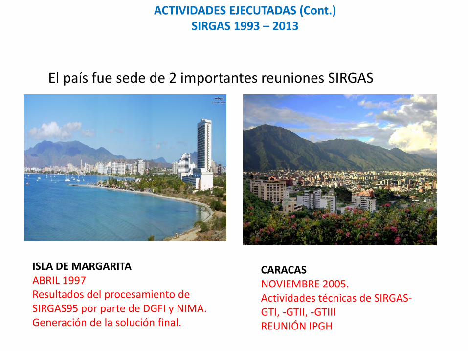
El país fue sede de 2 importantes reuniones SIRGAS
ACTIVIDADES EJECUTADAS (Cont.) SIRGAS 1993 – 2013
ISLA DE MARGARITA ABRIL 1997 Resultados del procesamiento de SIRGAS95 por parte de DGFI y NIMA. Generación de la solución final.
CARACAS NOVIEMBRE 2005. Actividades técnicas de SIRGAS-GTI, -GTII, -GTIII REUNIÓN IPGH
PLANES FUTUROS Y RETOS
Generar un modelo nacional de velocidades que modele los movimientos de la corteza terrestre.
Brindar a la comunidad de usuarios GNSS información para la georreferenciación de los proyectos, estudios e investigaciones vinculados directamente al Sistema Geodésico Nacional SIRGAS– REGVEN: REMOS, NTRIP, www.igvsb.gob.ve
Proveer un sistema de referencia adaptado a las nuevas tecnologías y necesidades de los usuarios: SIRGAS – REGVEN y REMOS
Establecimiento – recuperación de la Red Gravimétrica Nacional, cooperación con la USP, Brasil.
Proveer mas estaciones continuas para la red SIRGAS - CON.
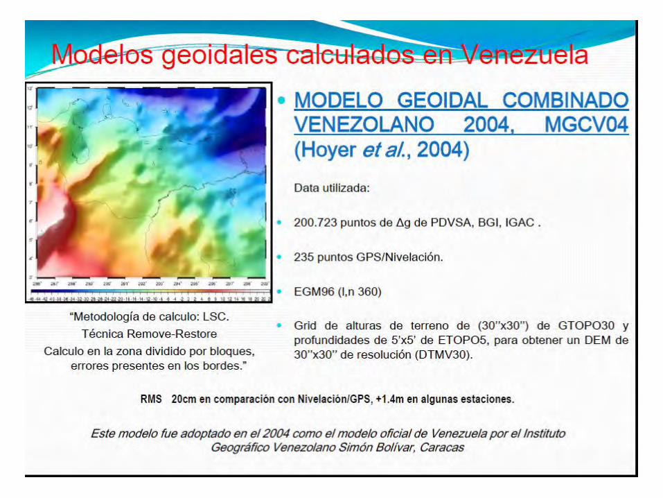
Determinación del Geoide más exacto para Venezuela.
PLANES FUTUROS Y RETOS (Cont.)
Crear el Centro Nacional de Procesamiento SIRGAS - REMOS
Continuar con las actividades de SIRGAS GT III.
COMENTARIO FINAL
Como puede observarse Venezuela ha sido un actor permanente en esta importante iniciativa continental que ya alcanza veinte años y en la cual, a pesar de la nutrida participación de países, se ha logrado una perfecta coordinación en la colaboración y apoyo para compartir los avances técnicos y científicos, acompañados siempre de una camaradería familiar muy característica.
Asunción, Paraguay, 1993
Ciudad de Panamá, Panamá, 2013
GRACIAS POR SU ATENCION


![Geodesia Para Dummies 1_geometria Del Elipsoide [130411]](https://img.pdfslide.tips/doc/110x75/55721027497959fc0b8cb56c/geodesia-para-dummies-1geometria-del-elipsoide-130411.jpg)