Embed Size (px)
Citation preview

Spatial change detection using voxel classification by normaldistributions transform
Ukyo Katsura1, Kohei Matsumoto1, Akihiro Kawamura2, Tomohide Ishigami3,Tsukasa Okada3, and Ryo Kurazume2
Abstract—Detection of spatial change around a robot isindispensable in several robotic applications, such as search andrescue, security, and surveillance. The present paper proposesa fast spatial change detection technique for a mobile robotusing an on-board RGB-D/stereo camera and a highly precise3D map created by a 3D laser scanner. This technique firstconverts point clouds in a map and measured data to griddata (ND voxels) using normal distributions transform andclassifies the ND voxels into three categories. The voxels inthe map and the measured data are then compared accordingto the category and features of the ND voxels. Overlappingand voting techniques are also introduced in order to detectthe spatial changes more robustly. We conducted experimentsusing a mobile robot equipped with real-time range sensors toconfirm the performance of the proposed real-time localizationand spatial change detection techniques in indoor and outdoorenvironments.
I. INTRODUCTION
Spatial change detection is a fundamental technique forfinding the differences between two or more pieces ofgeometrical information. This technique is critical in sev-eral applications, such as topographic change detection inairborne laser scanning [1] [2] or terrestrial laser scanning[3] [4], map maintenance in urban areas [5], preservationof cultural heritage [6], and analysis of plant growth [7].In robotics, detection of spatial changes around a robot isindispensable in several robotic applications, such as searchand rescue, security, and surveillance. Service robots, suchas cleaning robots or delivery robots, which are used on adaily basis, require the ability of spatial change detection inorder to safely and efficiently co-exist with humans, becausethe environment can change dynamically according to humanbehavior. For these service robots, precise localization is alsorequired in order to perform a desired task.Two-dimensional LiDARs, such as Hokuyo TOPURG and
Sick TiM51x, have commonly been used for the localizationof mobile robots due to their low cost, small size, and highprecision [8][9][10]. On the other hand, in recent years,with the widespread use of low-cost 3D laser scanners,such as FARO Focus 3D, and 3D range sensors, such
1Ukyo Katsura and Kohei Matsumoto are with GraduateSchool of Information Science and Electrical Engineering,Kyushu University, Fukuoka 819-0395, Japan {katsura,matsumoto}@irvs.ait.kyushu-u.ac.jp
2Akihiro Kawamura and Ryo Kurazume are with Faculty of InformationScience and Electrical Engineering, Kyushu University, Fukuoka 819-0395,Japan {kawamura, kurazume}@ait.kyushu-u.ac.jp
3Tomohide Ishigami and Tsukasa Okada are with Panasonic Inc.,3-1-1 Yagumo-naka-machi, Moriguchi City, Osaka 570-8501, Japan{ishigami.tomohide, okada.tsukasa}@jp.panasonic.com
as Kinect, Xtion, and Velodyne HDL-32e, 3D localization(or 6D localization, including attitude) is also becomingavailable in robotic applications using highly accurate 3Dmapping and real-time 3D range data. However, in general,data measured by these sensors consist of millions of 3Dpoints, which are referred to collectively as a point cloud.Real-time processing of a large number of point clouds istherefore not a trivial task. For example, although iterativeclosest point (ICP) [11] is a popular technique for aligningpoint clouds, ICP requires the determination of point-to-point (or mesh) correspondences, and thus the calculationcost remains too large for real-time localization or spatialchange detection by a mobile robot using point clouds.In order to deal with the enormous number of points
in a point cloud for robust robot localization, we haveproposed a fast localization technique using normal distri-butions transform (NDT)[12] and a particle filter [13]. Inthe present paper, as an additional function of the proposedlocalization technique [13], we propose a fast spatial changedetection technique by comparing 3D range data obtainedby an on-board RGB-D/stereo camera and a high-precision3D map created by a 3D laser scanner. This technique firstconverts point clouds in the map and measured data to griddata (ND voxels) by NDT, and classifies the voxels intothree categories. The voxels in the map and the measureddata are then compared according to the category andfeatures of ND voxels. Overlapping and voting techniquesare also introduced in order to detect spatial changes morerobustly. We conducted the experiments using a mobile robotequipped with real-time range sensors in order to confirmthe performance of the proposed real-time localization andspatial change detection techniques in indoor and outdoorenvironments.
II. RELATED RESEARCH
Spatial change detection is a critical problem in somerobotic applications [14] [15] [16] [17] [18], [19]. Andreas-son et al. [14] proposed autonomous change detection for asecurity patrol robot. They used color and depth informationobtained from a 3D laser range finder and a camera. Aprecise reference model was first created from multiple colorand depth images and was registered by 3D normal dis-tributions transform (3D-NDT) [20] representation. Spatialchanges are detected by calculating the probabilistic valueof the current point being different from the reference modelusing the 3D-NDT representation and color information.Saarinen et al. [21] proposed Normal Distributions Trans-
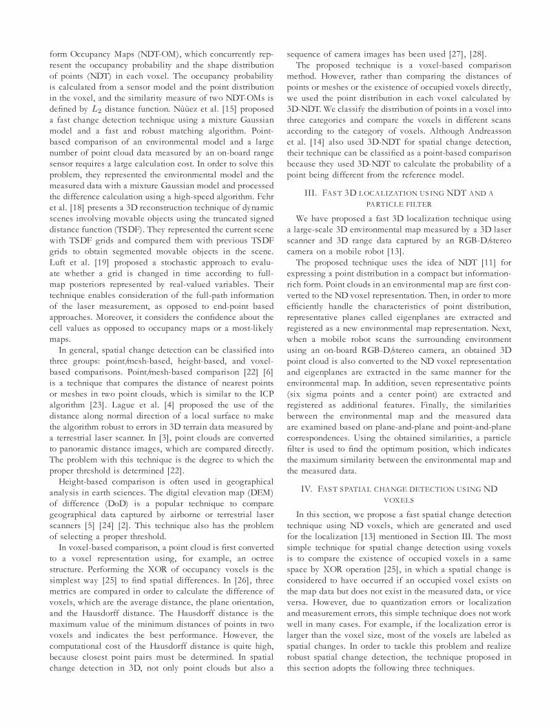
form Occupancy Maps (NDT-OM), which concurrently rep-resent the occupancy probability and the shape distributionof points (NDT) in each voxel. The occupancy probabilityis calculated from a sensor model and the point distributionin the voxel, and the similarity measure of two NDT-OMs isdefined by L2 distance function. Nuuez et al. [15] proposeda fast change detection technique using a mixture Gaussianmodel and a fast and robust matching algorithm. Point-based comparison of an environmental model and a largenumber of point cloud data measured by an on-board rangesensor requires a large calculation cost. In order to solve thisproblem, they represented the environmental model and themeasured data with a mixture Gaussian model and processedthe difference calculation using a high-speed algorithm. Fehret al. [18] presents a 3D reconstruction technique of dynamicscenes involving movable objects using the truncated signeddistance function (TSDF). They represented the current scenewith TSDF grids and compared them with previous TSDFgrids to obtain segmented movable objects in the scene.Luft et al. [19] proposed a stochastic approach to evalu-ate whether a grid is changed in time according to full-map posteriors represented by real-valued variables. Theirtechnique enables consideration of the full-path informationof the laser measurement, as opposed to end-point basedapproaches. Moreover, it considers the confidence about thecell values as opposed to occupancy maps or a most-likelymaps.In general, spatial change detection can be classified into
three groups: point/mesh-based, height-based, and voxel-based comparisons. Point/mesh-based comparison [22] [6]is a technique that compares the distance of nearest pointsor meshes in two point clouds, which is similar to the ICPalgorithm [23]. Lague et al. [4] proposed the use of thedistance along normal direction of a local surface to makethe algorithm robust to errors in 3D terrain data measured bya terrestrial laser scanner. In [3], point clouds are convertedto panoramic distance images, which are compared directly.The problem with this technique is the degree to which theproper threshold is determined [22].Height-based comparison is often used in geographical
analysis in earth sciences. The digital elevation map (DEM)of difference (DoD) is a popular technique to comparegeographical data captured by airborne or terrestrial laserscanners [5] [24] [2]. This technique also has the problemof selecting a proper threshold.In voxel-based comparison, a point cloud is first converted
to a voxel representation using, for example, an octreestructure. Performing the XOR of occupancy voxels is thesimplest way [25] to find spatial differences. In [26], threemetrics are compared in order to calculate the difference ofvoxels, which are the average distance, the plane orientation,and the Hausdorff distance. The Hausdorff distance is themaximum value of the minimum distances of points in twovoxels and indicates the best performance. However, thecomputational cost of the Hausdorff distance is quite high,because closest point pairs must be determined. In spatialchange detection in 3D, not only point clouds but also a
sequence of camera images has been used [27], [28].The proposed technique is a voxel-based comparison
method. However, rather than comparing the distances ofpoints or meshes or the existence of occupied voxels directly,we used the point distribution in each voxel calculated by3D-NDT. We classify the distribution of points in a voxel intothree categories and compare the voxels in different scansaccording to the category of voxels. Although Andreassonet al. [14] also used 3D-NDT for spatial change detection,their technique can be classified as a point-based comparisonbecause they used 3D-NDT to calculate the probability of apoint being different from the reference model.
III. FAST 3D LOCALIZATION USING NDT AND APARTICLE FILTER
We have proposed a fast 3D localization technique usinga large-scale 3D environmental map measured by a 3D laserscanner and 3D range data captured by an RGB-D/stereocamera on a mobile robot [13].The proposed technique uses the idea of NDT [11] for
expressing a point distribution in a compact but information-rich form. Point clouds in an environmental map are first con-verted to the ND voxel representation. Then, in order to moreefficiently handle the characteristics of point distribution,representative planes called eigenplanes are extracted andregistered as a new environmental map representation. Next,when a mobile robot scans the surrounding environmentusing an on-board RGB-D/stereo camera, an obtained 3Dpoint cloud is also converted to the ND voxel representationand eigenplanes are extracted in the same manner for theenvironmental map. In addition, seven representative points(six sigma points and a center point) are extracted andregistered as additional features. Finally, the similaritiesbetween the environmental map and the measured dataare examined based on plane-and-plane and point-and-planecorrespondences. Using the obtained similarities, a particlefilter is used to find the optimum position, which indicatesthe maximum similarity between the environmental map andthe measured data.
IV. FAST SPATIAL CHANGE DETECTION USING NDVOXELS
In this section, we propose a fast spatial change detectiontechnique using ND voxels, which are generated and usedfor the localization [13] mentioned in Section III. The mostsimple technique for spatial change detection using voxelsis to compare the existence of occupied voxels in a samespace by XOR operation [25], in which a spatial change isconsidered to have occurred if an occupied voxel exists onthe map data but does not exist in the measured data, or viceversa. However, due to quantization errors or localizationand measurement errors, this simple technique does not workwell in many cases. For example, if the localization error islarger than the voxel size, most of the voxels are labeled asspatial changes. In order to tackle this problem and realizerobust spatial change detection, the technique proposed inthis section adopts the following three techniques.

1) Classification of point distribution in an ND voxel2) Overlapping of voxels in map data3) Voting of spatial change detection through sequentialmeasurements
A. Classification of point distributions in ND voxels
If we use the simple technique for spatial change detectionby taking XOR between the map and the measured voxelsmentioned above, it is impossible to detect spatial changesif the voxel includes not only point clouds to be detected asspatial change but also other stationary point clouds such asa floor or a wall. The proposed technique solves this problemby classifying the point distribution in ND voxels into threecategories.In the calculation of NDT during the localization [13],
three eigenvalues λ1, λ2, λ3 (λ1 < λ2 < λ3) and eigenvec-tors of a covariance matrix of a point cloud in a voxel areobtained. According to the following criteria, we classify thepoint distribution in ND voxels into three categories, that is,“Sphere”, “Sheet”, and “Line”. In addition, if there are nomeasured points in a voxel, then we refer to the voxel as“Empty”.
Sphere λ3 ≈ λ2 ≈ λ1 � 0 (1)
Sheet λ3 ≈ λ2 � λ1 ≈ 0 (2)
Line λ3 � λ2 ≈ λ1 ≈ 0 (3)
Magnusson et al. [29] also proposed a loop detectiontechnique using the histogram of three shapes (spherical,planar, and linear), which are classified from point cloudsaccording to the eigenvalues. In our case, we use theseclassifications to evaluate the difference between the mapand measured voxels.If the voxels in the map and measured data are labeled
with different categories, then we say that there is a spatialchange in this space of the voxel. In addition, even ifboth voxels have the same labels of “Sheet” or “Line”, wecompare the normal or direction vectors of the sheets and thelines, which are the eigenvectors corresponding to minimumand maximum eigenvalues, respectively. If these vectors aresufficiently matched, then we consider these voxels to havethe same labels and ignore their spatial change.
(nmap,nmeasured) < Nt (Sheets) (4)
(vmap,vmeasured) < Vt (Lines) (5)
where n and v are the normal and direction vectors of thesheets and the lines which are eigenvectors corresponding tothe smallest and the largest eigenvalues, and Nt and Vt areproper thresholds. nmap and vmap are calculated beforehandfrom the environmental map (point cloud) measured by a 3Dlaser scanner, and nmeasured and vmeasured are obtainedusing the measured map (point cloud) by an on-board RGB-D/stereo camera. In the experiments in Section VI, we set Nt
and Vt as 0.5. Similar idea can be seen in [26], in which ”bestfitting plane orientation” was used to evaluate the spatialchanges.
B. Overlapping of voxels in map data
The proposed technique inherently involves a quantizationerror because we divide the entire space into several voxelgrids and perform NDT for each voxel. Thus, the classifi-cation mentioned above is also affected by the quantizationerror. For example, the boundary between a floor and a wallis classified as “Sheet” if the majority of points in the voxelbelong to either a floor or a wall. On the other hand, theboundary is classified as “Sphere” if both planes are evenlyincluded.In order to suppress the influence of quantization error,
the proposed technique uses overlapping ND voxels [12];that is, adjacent voxels overlap each other so that the centersof the voxels are displaced with half the voxel size. As aresult, every point in 3D space is involved with eight adjacentvoxels. Thus, by comparing a voxel in the measured data withup to 27 adjacent voxels in the map data, we can evaluatethe degree of coincidence of the map and the measureddata robustly with respect to the quantization error. Moreprecisely, if at least one voxel in 27 voxels in the map data issimilar enough to the voxel in the measured data, that voxelis marked as ”no change”. In the proposed technique, theND voxels in the map overlap, and ND voxels are calculatedbeforehand in order to reduce the on-line calculation cost.
C. Voting of spatial change detection through sequentialmeasurements
The measurement data taken from an RGB-D/stereo cam-era, such as Kinect or a stereo camera, are corrupted bynoise, and the measurement noise tends to be detectedas spatial change in some cases. Therefore, we adopt avoting technique through sequential measurements in orderto suppress the effect of the measurement noise. Here, wefirst extract the voxels that are regarded as spatially changedvoxels in each measured datum. Then, by voting on theseresults for the space in a global coordinate system with thefollowing weights according to the 3D normal distribution,the regions of spatial change can be obtained robustly.
w(p) = N(c, σ2) (6)
where p is the center of the adjacent voxel in the map dataand c is the center of the original voxel in the measured data.In the experiments in Section VI, we set the voxel size as
400 mm and σ as 200 mm, and voted for the information ofthe spatial change to 27 adjacent voxels.
V. MOBILE ROBOT SYSTEM FOR LOCALIZATION AND
SPATIAL CHANGE DETECTION
In order to confirm the performance of the proposedlocalization and spatial change detection techniques, we builta mobile robot system equipped with an omni-directionallaser scanner (Velodyne HDL-32e) and an RGB-D camera(Kinect for Xbox One, Microsoft), as shown in Fig. 1.For localization, point cloud data measured by the omni-directional laser scanner are compared with a large-scale 3Dmap measured by a high-precision laser scanner (Focus 3D,

FARO). However, the number of scanning lines of the omni-directional laser scanner is 32, which is not sufficient fordetecting spatial changes in small regions. Thus, the RGB-Dcamera is used to capture detailed range data in front of therobot for spatial change detection.
Velodyne HDL-32e
Kinect for Xbox One
Fig. 1. Mobile robot system equipped with an omni-directional laserscanner (Velodyne HDL-32e) and an RGB-D camera (Kinect, Microsoft).
VI. EXPERIMENTS IN INDOOR AND OUTDOORENVIRONMENTS
A. Indoor experiments
We conducted an experiment for spatial change detectionin an indoor environment (a hall) in order to confirm theperformance of the proposed technique. We first scanned thehall from eight positions using a high-precision laser scanner(Faro Focus 3D) and obtained an environmental map withdimensions of 40 m × 11 m. Figure 2 shows the obtained3D point cloud and ND voxel representation.
Fig. 2. 3D environmental map and ND voxel representation. Red, green,and blue cubes are voxels labeled sphere, line, and sheet, respectively.
Next, we placed three objects, as shown in Fig. 4, havingdimensions of a© 10 cm × 10 cm × 10 cm ( 1© and 5©), b©20 cm × 20 cm × 20 cm ( 2© and 6©), c© 30 cm × 30 cm ×30 cm ( 3© and 7©), and d© 40 cm × 40 cm × 40 cm ( 4© and8©) at the positions shown in Fig. 3. The robot (Fig. 1) thenmoves along the trajectory shown in Fig. 3 and attempts tofind these objects as spatial changes.
Initial position
Final position
5 m
1234
56
78
Fig. 3. Indoor environment (Hall: 40 m × 11 m).
The initial position of the robot is determined as follows.An initial position is first roughly assigned by hand. Theaccurate position is then estimated using the omni-directional
a b c d
1
23
4
5 6
7 8
Fig. 4. Objects placed in the pathway.
laser scanner and the environmental map by the positioningtechnique in Section III [13], which is based on the compar-ison of ND voxels and optimization using a particle filter.The target position is determined manually, and the path tothe target position is determined by Dijkstra’s algorithm inthe navigation package in the robot operating system (ROS).The robot moves along the desired path automatically andfuses the position information from the particle filter [13] andodometry at 1 Hz. The range data from the RGB-D camera(measured data) are transformed using the estimated positioninformation and compared with the environmental map usingthe proposed technique. In this experiment, the voxel size forlocalization and the spatial change detection is 40 cm.Table I shows the positioning errors in cases that the voxel
size is 40 [cm] and 100 [cm]. The actual robot position ismeasured by the high-precision laser scanner (Faro Focus3D) placed at a known position. In this experiment, thenumber of particles is fixed to 400. From this table, we cansee that the accuracy for the localization is about 10 [cm]and not so different for the cases that the voxel sizes are 40[cm] and 100 [cm].
TABLE I
POSITIONING ERRORS
Voxel size Error40 [cm] 99.2 [mm]100 [cm] 104.6 [mm]
Figure 5(e) shows the detected spatial changes by theproposed method. Though one region is misdetected asindicated by a white circle, the four kinds of objects that areplaced at eight positions later are correctly detected in thisexperiment. We run the robot from the same initial positionto the target position by taking RGB-D data ten times, andobtained the detection rate of the spatial changes as shownin Table II. Note that we considered the object is detectedin case that at least one voxel containing vertexes, edges, orplanes of the object is detected as spatially changed.
TABLE II
THE DETECTION RATE FOR FOUR KINDS OF OBJECTS
Object (size) Detection rate [%]Proposed 3D-NDT[14] L2 [21]
A (400 × 400 mm) 100 100 95B (300 × 300 mm) 100 100 95C (200 × 200 mm) 85 75 50D (100 × 100 mm) 50 15 0
We also compared the performance of the proposedmethod with the 3D-NDT based spatial change detection

Misdetected regions
Undetected objects
(a) 3D-NDT based spatial change detection [14]
Misdetected regions
Undetected objects
(b) L2 distance function [21]
Misdetected regions
(c) Taking XOR of occupancy voxels [25]
Misdetected regions
Undetected objects
(d) Taking XOR of overlapped occupancy voxels
Misdetected regions
(e) Proposed method
Fig. 5. Detected changes by (a) 3D-NDT based spatial change detection[14], (b) L2 distance function [21], (c) taking XOR of occupancy voxels[25], (d) taking XOR of overlapped occupancy voxels, and (e) proposedmethod. Misdetected regions and undetected objects are indicated by whitecircles and crosses.
by Andreasson et al. [14], L2 distance function [21], andsimple methods using XOR calculation [25]. Figure 5(a)shows the detected spatial changes by the 3D-NDT basedmethod [14]. In this experiment, we used the depth imagescaptured by the RGB-D camera only and the color imageswere not used. Although the changed regions are mostlydetected, some regions are misdetected or undetected. TableII shows the detection rate for each object by the 3D-NDTbased spatial change detection after ten trials. These resultsshow that the proposed method outperforms the 3D-NDTbased spatial change detection especially in case that smallobjects are placed. Although it may be possible to improvethe detection rate by decreasing the threshold for evaluatingthe spatial change, this induces many misdetection as shownin Fig, 5(a).Figure 5(b) shows the detected spatial changes by L2
distance function [21]. Figures 5(c) and (d) show the detectedspatial changes by taking XOR between the map and themeasured voxels [25]. Figure 5(d) uses the overlapped voxelsin the map and we judged that the voxel is not spatiallychanged if at least one voxel among 27 map voxels adjacentto the measured voxel is occupied. In these experimentsusing XOR calculation, a number of misdetected regions arefound, which are mainly caused by the positioning error ofthe mobile robot. On the other hand, the proposed method(Fig. 5(e)) is robust against position error due to voxelclassification and voting technique.Finally, we show the precision and recall of the detection
of voxels which are specially changed for each method
in Table III. We used the overlapped voxels in the mapand considered the voxel in the map should be detected asspatially changed if it contains vertexes, edges, or planesof the objects. Table III shows that the proposed method,which uses classification of point distribution, overlappingvoxels, and voting techniques, gives highest precision (98.50%) and outperforms other techniques. Figure 6 shows PRand ROC curves for each method using various parameters.In these figures, we can say that the proposed techniqueoutperforms the conventional 3D-NDT [14] and L2 distancebased techniques. Note that the recalls are considerably lowin all methods. This is because all voxels including at leastone vertex, edge, or plane of the object are regarded as thecorrect voxels to be detected, and therefore, for example,the voxels on a wall hidden by the object are considered asmissing voxels which are not correctly detected.
TABLE III
PRECISION AND RECALL [%]
Precision Recall3D-NDT [14] 61.90 4.79L2 [21] 81.19 1.11XOR [25] 17.55 3.95XOR (overlapped) 69.99 1.71Classification 22.74 2.47Classification, overlapping 61.77 26.06Classification, overlapping, voting (Proposed) 98.50 7.58
0
20
40
60
80
100
0 5 10 15 20 25 30
Proposed
3D-NDT
L₂
Recall
Pre
cisi
on
(a) PR Curve
0
5
10
15
20
25
30
0 5 10 15 20 25 30 35 40
FPR
Rec
all
(b) ROC Curve
Proposed
3D-NDT
L₂
Fig. 6. PR and ROC curves.
B. Processing time for localization and spatial change de-tection
We measured the processing time for localization andspatial change detection in this experiment. Table IV showsthe average processing time for one cycle of each stepduring the experiments (Intel Core i7, 3.40GHz). The averageprocessing time for spatial change detection by the proposedtechnique is 21.3 millisecond including the conversion pro-cess of the depth images captured by the RGB-D camerato the ND voxel representation. On the other hand, the pro-cessing time by the 3D-NDT based spatial change detection[14] is 563.6 millisecond and the proposed technique is 26.5times faster than the 3D-NDT based technique. The simplemethod using XOR calculation [25] is slightly faster thanthe proposed method. Note that, since these processes canbe executed independently, we run processes of localizationand spatial change detection at 1 Hz in the experiments.

TABLE IV
PROCESSING TIME FOR EACH STEP
Localization 827.2 [msec]3D-NDT[14] 570.0 [msec]L2 [21] 17.2 [msec]
Spatial change detection XOR[25] 17.9 [msec]XOR (overlapped) 19.4 [msec]Proposed 20.4 [msec]
C. Outdoor experiments
In these experiments, we first scan the outdoor environ-ment (road) from three positions using a high-precision laserscanner (Faro Focus 3D) and obtained an environmental maphaving dimensions of 30 m × 10 m. We then placed fourobjects having dimensions of 1©, 40 cm × 40 cm × 40cm; 2©, 40 cm × 40 cm × 80 cm; 3©, 80 cm × 15 cm ×60 cm; and 4©, 40 cm × 40 cm × 20 cm, and the robotmoves 30 m along a straight line. Here, we replaced theRGB-D camera with a conventional stereo camera systembecause acquiring range data in direct sunlight using theRGB-D camera (Kinect for Xbox One) becomes extremelydifficult. We captured 430 range images using the stereocamera system during the movement.Figure 8(a) shows the detected regions (red, green, and
blue cubes), which are estimated to be spatially changedusing XOR calculation of the occupied voxels [25]. Figures8(b), 8(c), and 8(d) show the detected regions using theclassification of point distribution (Section IV-A), classifica-tion and overlapping of voxels in map data (Section IV-B),and classification, overlapping, and voting of spatial changedetection through sequential measurements (SectionIV-C),respectively. In Fig. 8, detected voxels classified as “Sphere”,“Sheet”, and “Line” are illustrated by red, blue, and greencubes, respectively. Table V shows the number of voxels de-tected as spatial changes in these experiments. As shown Fig.8(d), the voxels with spatial changes are detected correctly ifwe apply all of the techniques proposed in Section IV, thatis, classification of point distribution, overlapping of voxelsin map data, and voting of spatial change detection.
TABLE V
NUMBER OF VOXELS DETECTED AS SPATIAL CHANGES
XOR 704Classification 364Classification and overlapping 313Classification, overlapping, and voting (Proposed) 48
1
23 4
Fig. 7. Four additional objects in an outdoor environment.
Detected changes
(a) XOR calculation ofoccupied voxels
Detected changes
(b) Classification of pointdistribution
Detected changes
(c) Classification of pointdistribution andoverlapping
Detected changes
(d) Proposed method(classification,
overlapping, and voting)Fig. 8. Detected spatial changes (red, blue, and green cubes) in an outdoorenvironment.
VII. CONCLUSIONS
The present paper proposed a fast spatial change detectiontechnique for a mobile robot using an on-board RGB-D/stereo camera and a high-precision 3D map created usinga 3D laser scanner. This technique first converts point cloudsin a map and measured data to grid data (ND voxels) usingNDT and classifies the voxels into three categories. Thevoxels in the map and measured data are then comparedaccording to the category and features of the ND voxels.The proposed technique consists of the following threetechniques.
1) Classification of the point distribution2) Overlapping of voxels in map data3) Voting of spatial change detection through sequentialmeasurements
We conducted experiments using a mobile robot equippedwith real-time range sensors in order to confirm the per-formance of the proposed real-time localization and spatialchange detection techniques in indoor and outdoor environ-ments.Future work includes performance evaluation of actual
scenes, such as stations or market areas, and improvement ofthe performance by using other information, such as coloror laser reflectance. In particular, laser reflectance, whichis obtained as a side product of range measurement by alaser scanner, is measured stably independent of the lightingcondition, even at night. Therefore, as additional information,evaluating the spatial change robustly is very useful.
ACKNOWLEDGMENT
This research is supported by JSPS KAKENHI GrantNumber JP26249029.
REFERENCES
[1] M. Hebel, M. Arens, and U. Stilla, “Change detection in urban areasby object-based analysis and on-the-fly comparison of multi-view alsdata,” ISPRS Journal of Photogrammetry and Remote Sensing, vol. 86,pp. 52–64, 2013.
[2] T. T. Vu, M. Matsuoka, and F. Yamazaki, “Lidar-based change detec-tion of buildings in dense urban areas,” in IGARSS 2004. 2004 IEEEInternational Geoscience and Remote Sensing Symposium, vol. 5,pp. 3413–3416 vol.5, Sept 2004.
[3] R. Zeibak and S. Filin, “Change detection via terrestrial laser scan-ning,” International Archives of Photogrammetry and Remote Sensing,vol. 36, no. 3, pp. 430–435, 2007.
[4] D. Lague, N. Brodu, and J. Leroux, “Accurate 3d comparison ofcomplex topography with terrestrial laser scanner: Application tothe rangitikei canyon (n-z),” ISPRS Journal of Photogrammetry andRemote Sensing, vol. 82, pp. 10 – 26, 2013.
[5] B. Thomas, C. Remco, W. Zachary, and R. William, “Visual analysisand semantic exploration of urban lidar change detection,” ComputerGraphics Forum, vol. 27, no. 3, pp. 903–910, 2008.
[6] G. Palma, M. Sabbadin, M. Corsini, and P. Cignoni, “Enhanced vi-sualization of detected 3d geometric differences,” Computer GraphicsForum, vol. 37, pp. 159–171, 2 2018.
[7] Y. Li, X. Fan, N. J. Mitra, D. Chamovitz, D. Cohen-Or, and B. Chen,“Analyzing growing plants from 4d point cloud data,” ACM Trans.Graph., vol. 32, pp. 157:1–157:10, Nov. 2013.
[8] D. Filliat and J.-A. Meyer, “Map-based navigation in mobile robots::I. a review of localization strategies,” Cognitive Systems Research,vol. 4, no. 4, pp. 243 – 282, 2003.
[9] S. Thrun, D. Fox, W. Burgard, and F. Dellaert, “Robust monte carlolocalization for mobile robots,” Artificial Intelligence, vol. 128, no. 1,pp. 99 – 141, 2001.
[10] S. Thrun, W. Burgard, and D. Fox, Probabilistic Robotics (IntelligentRobotics and Autonomous Agents). The MIT Press, 2005.
[11] A. Nuchter, H. Surmann, K. Lingemann, J. Hertzberg, and S. Thrun,“6d slam with an application in autonomous mine mapping,” inRobotics and Automation, 2004. Proceedings. ICRA ’04. 2004 IEEEInternational Conference on, vol. 2, pp. 1998–2003 Vol.2, April 2004.
[12] P. Biber and W. Strasser, “The normal distributions transform: a newapproach to laser scan matching,” in Proceedings 2003 IEEE/RSJInternational Conference on Intelligent Robots and Systems (IROS2003) (Cat. No.03CH37453), vol. 3, pp. 2743–2748 vol.3, Oct 2003.
[13] S. Oishi, Y. Jeong, R. Kurazume, Y. Iwashita, and T. Hasegawa, “Ndvoxel localization using large-scale 3d environmental map and rgb-d camera,” in 2013 IEEE International Conference on Robotics andBiomimetics (ROBIO), pp. pp.538–545, 2013.
[14] H. Andreasson, M. Magnusson, and A. Lilienthal, “Has somethingchanged here? autonomous difference detection for security patrolrobots,” in 2007 IEEE/RSJ International Conference on IntelligentRobots and Systems, pp. 3429–3435, Oct 2007.
[15] P. Nuuez, P. Drews, A. Bandera, R. Rocha, M. Campos, and J. Dias,“Change detection in 3d environments based on gaussian mixturemodel and robust structural matching for autonomous robotic appli-cations,” in 2010 IEEE/RSJ International Conference on IntelligentRobots and Systems, pp. 2633–2638, Oct 2010.
[16] J. P. Underwood, D. Gillsjo, T. Bailey, and V. Vlaskine, “Explicit3d change detection using ray-tracing in spherical coordinates,” in2013 IEEE International Conference on Robotics and Automation,pp. 4735–4741, May 2013.
[17] A. W. Vieira, P. L. J. Drews, and M. F. M. Campos, “Spatialdensity patterns for efficient change detection in 3d environment forautonomous surveillance robots,” IEEE Transactions on AutomationScience and Engineering, vol. 11, pp. 766–774, July 2014.
[18] M. Fehr, F. Furrer, I. Dryanovski, J. Sturm, I. Gilitschenski, R. Sieg-wart, and C. Cadena, “Tsdf-based change detection for consistent long-term dense reconstruction and dynamic object discovery,” in 2017IEEE International Conference on Robotics and Automation (ICRA),pp. 5237–5244, May 2017.
[19] L. Luft, A. Schaefer, T. Schubert, and W. Burgard, “Detecting changesin the environment based on full posterior distributions over real-valued grid maps,” IEEE Robotics and Automation Letters, vol. 3,pp. 1299–1305, April 2018.
[20] P. Biber and W. Strasser, “The normal distributions transform: a newapproach to laser scan matching,” in Proceedings 2003 IEEE/RSJInternational Conference on Intelligent Robots and Systems (IROS2003) (Cat. No.03CH37453), vol. 3, pp. 2743–2748 vol.3, Oct 2003.
[21] J. P. Saarinen, H. Andreasson, T. Stoyanov, and A. J. Lilienthal, “3dnormal distributions transform occupancy maps: An efficient repre-sentation for mapping in dynamic environments,” The InternationalJournal of Robotics Research, vol. 32, no. 14, pp. 1627–1644, 2013.
[22] P. Gianpaolo, C. Paolo, B. Tamy, and S. Roberto, “Detection ofgeometric temporal changes in point clouds,” Computer GraphicsForum, vol. 35, no. 6, pp. 33–45, 2016.
[23] P. J. Besl and N. D. McKay, “A method for registration of 3-d shapes,”IEEE Transactions on Pattern Analysis and Machine Intelligence,vol. 14, pp. 239–256, Feb 1992.
[24] H. Murakami, K. Nakagawa, H. Hasegawa, T. Shibata, andE. Iwanami, “Change detection of buildings using an airborne laserscanner,” ISPRS Journal of Photogrammetry and Remote Sensing,vol. 54, no. 2, pp. 148 – 152, 1999.
[25] “Spatial change detection on unorganized point cloud data.”http://pointclouds.org/documentation/tutorials/octree_change.php.
[26] D. Girardeau-Montaut, M. Roux, R. Marc, and G. Thibault, “Changedetection on points cloud data acquired with a ground laser scanner,”International Archives of Photogrammetry, Remote Sensing and Spa-tial Information Sciences, vol. 36, no. PART 3, pp. 30–35, 2005.
[27] T. Pollard and J. L. Mundy, “Change detection in a 3-d world,” in2007 IEEE Conference on Computer Vision and Pattern Recognition,pp. 1–6, June 2007.
[28] A. O. Ulusoy and J. L. Mundy, “Image-based 4-d reconstruction using3-d change detection,” in Computer Vision – ECCV 2014 (D. Fleet,T. Pajdla, B. Schiele, and T. Tuytelaars, eds.), (Cham), pp. 31–45,Springer International Publishing, 2014.
[29] M. Magnusson, H. Andreasson, A. Nuchter, and A. J. Lilienthal,“Appearance-based loop detection from 3d laser data using the normaldistributions transform,” in 2009 IEEE International Conference onRobotics and Automation, pp. 23–28, May 2009.