Embed Size (px)
Citation preview
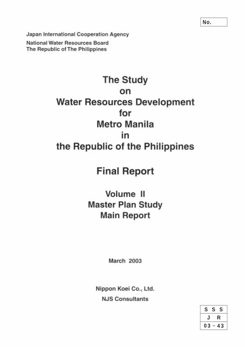
No.
S S S
0 3 4 3
J R

List of Volumes
Volume I : Executive Summary Volume II : Phase 1: Master Plan Study - Main Report Volume III : Phase 1: Master Plan Study - Supporting Report Volume IV : Phase 2: Feasibility Study - Main Report Volume V : Phase 2: Feasibility Study – Supporting Report Volume VI : Phase 2: Feasibility Study - Data Book
The cost estimate is based on the price level and exchange rate of June 2001.
The exchange rate is:
US$1.00 = PHP52.0 = ¥125.0
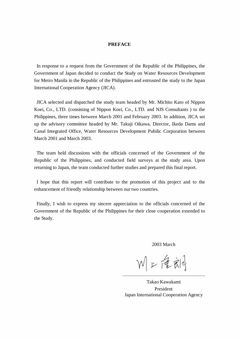
PREFACE
In response to a request from the Government of the Republic of the Philippines, the Government of Japan decided to conduct the Study on Water Resources Development for Metro Manila in the Republic of the Philippines and entrusted the study to the Japan International Cooperation Agency (JICA). JICA selected and dispatched the study team headed by Mr. Michito Kato of Nippon
Koei, Co., LTD. (consisting of Nippon Koei, Co., LTD. and NJS Consultants ) to the Philippines, three times between March 2001 and February 2003. In addition, JICA set up the advisory committee headed by Mr. Takuji Oikawa, Director, Ikeda Dams and Canal Integrated Office, Water Resources Development Pubilic Corporation between March 2001 and March 2003. The team held discussions with the officials concerned of the Government of the
Republic of the Philippines, and conducted field surveys at the study area. Upon returning to Japan, the team conducted further studies and prepared this final report. I hope that this report will contribute to the promotion of this project and to the
enhancement of friendly relationship between our two countries. Finally, I wish to express my sincere appreciation to the officials concerned of the
Government of the Republic of the Philippines for their close cooperation extended to the Study.
2003 March
Takao Kawakami President
Japan International Cooperation Agency

Summary
- 1 -
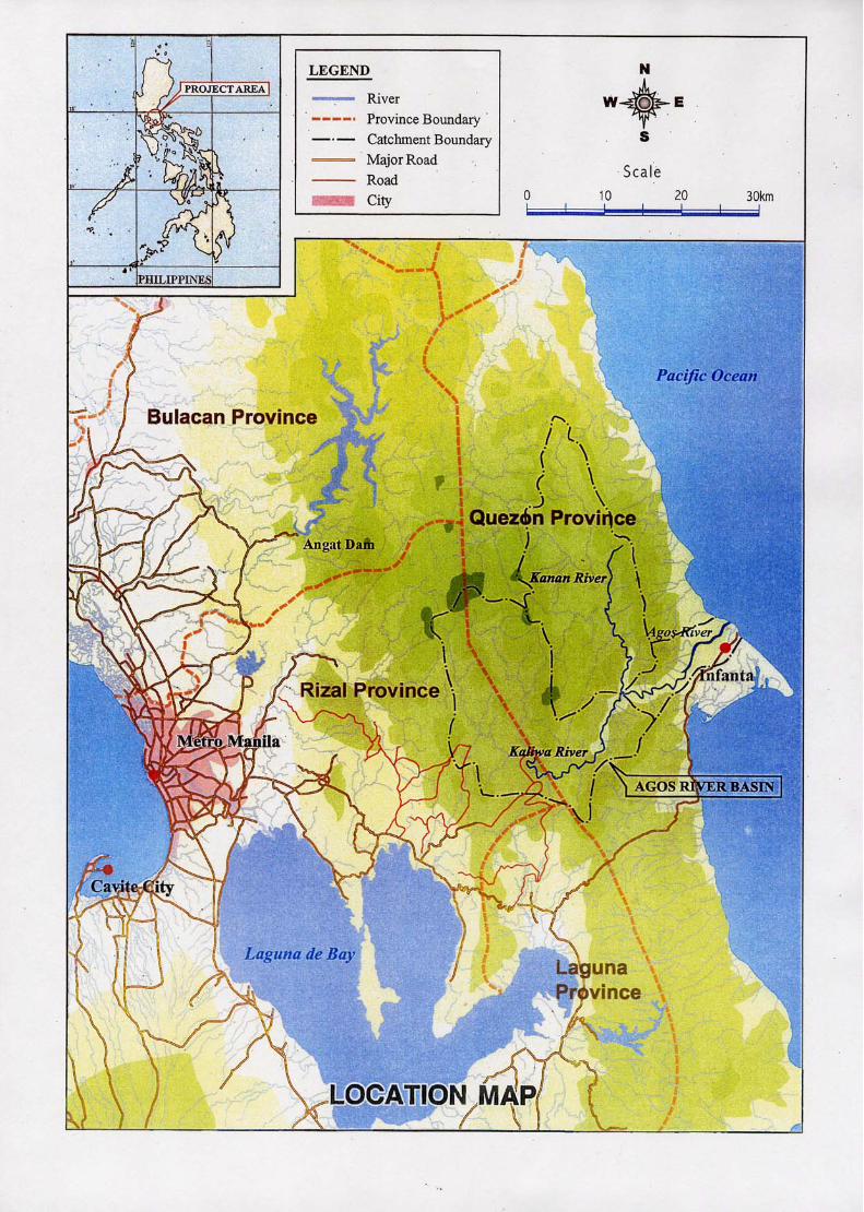
The Study on Water Resources Development for Metro Manila in the Republic of the Philippines
VOLUME II MASTER PLAN STUDY- MAIN REPORT
SUMMARY
Study Activities in Master Plan Stage: (Chapter I)
1. As the first phase program of the Study, the JICA Study Team carried out field investigation works and home office studies during the period from March 2001 to November 2001. The main subject of the first phase study was the preparation of a master plan for the water resources development for Metro Manila towards the year 2025 by exploiting the water resources in the Agos River Basin. This Volume II summarizes the outcomes from the master plan study. The report was submitted to NWRB as an Interim Report for the Study and explained to the Philippine side in January 2002.
Socio-Economic Framework: (Chapter II)
2. The future population in the Study area covering NCR, Rizal Province and a part of Cavite Province was projected for the period up to year 2025, the target year of the present Study. The projection aims at providing data for the estimate of future water demand in the Study area at city/municipality level.
Population Projection up to 2025 (Unit: 1,000)
Projected Population Annual Growth Rate
Population
2000 (Census)
2005 2010 2015 2020 2025 2000-2010
2010-2025
The Philippines Region IV
76,499 11,794
84,241 12,860
91,868 14,525
99,016 16,357
105,507 18,225
113,661 20,320
1.8% 2.1%
1.4% 2.3%
NCR *1 Cavite Province *2 Rizal Province *3 Study Area Total
9,933 2,063 1,707
13,073
10,680 2,357 2,152
15,189
11,291 2,411 2,681
16,383
12,434 2,715 3,409
18,558
12,854 2,987 4,222
20,063
13,241 3,250 5,139
21,630
1.3% 1.6% 4.6% 2.3%
1.0% 2.1% 4.4% 1.9%
Note: *1 12 cities and 5 municipalities *2 1 city (Cavite) and 5 municipalities *3 1 city (Antipolo) and 13 municipalities
As shown above, the population of the Study area is projected to increase at 2.3% and 1.9% for the periods of 2000-2010 and 2010-2025, respectively.
3. Gross Regional Domestic Product (GRDP) in the Study area was projected for the three major sectors of agriculture, industry and service for the period up to the year 2025. The GRDP projection is also needed to provide basic data for the estimate of future municipal and industrial water demands in the Study area.

Summary
- 2 -
GDP/GRDP Projections for 2000-2025 (Unit: Billion Pesos)
2000 2005 2010 2015 2020 2025 Growth 2000-25
Share to Nation 2025
Philippines (GDP) 962 1,236 1,604 2,097 2,760 3,652 5.5% NCR 294 388 520 696 933 1,250 6.0% 34.2% - Agriculture Sec. - Industrial Sec. - Service Sector
0 112 182
0 144 244
0 192 328
0 254 441
0 339 594
0 450 800
0% 5.7% 6.1%
0% 28.0% 44.7%
Region IV 148 191 249 328 435 582 5.6% 15.9% - Agriculture Sec. - Industrial Sec. - Service Sector
34 64 50
37 86 68
38 119 92
39 164 125
40 225 170
41 310 231
0.7% 6.5% 6.3%
16.1% 19.3% 12.9%
As shown above, the GRDP of NCR and Region IV is projected to grow at 6.0% and 5.6% per annum, respectively, for the period of 2000-2025, which is higher than the GDP growth of the whole country.
Water Demand Projection: (Chapter II)
4. Water demand consists of billed water (domestic + commercial + industrial) and non-revenue water (NRW). The projected water demand is summarized in the table below, together with the projection of per capita consumption, service coverage and NRW ratio:
Water Demand Projection up to Year 2025
Description 2000 2005 2010 2015 2020 2025 Projected Water Demand: (MLD)
Day average demand Day peak demand
3,663
(4,400)
3,783 4,577
4,250 5,143
5,033 6,090
5,866 7,097
6,980 8,446
Existing Supply Capacity (MLD) 4,090 Per capita consumption (Lpcd) Service coverage (%) Served population (1000)
119 69
8,120
125 71
9,703
139 75
11,286
153 81
13,785
170 88
16,147
188 97
19,109 Billed water (%) NRW ratio (%) of which, - Physical loss (%) - Commercial loss (%)
39.1 60.9 33.5 27.4
46 54 30 24
52 48 28 20
58 42 26 16
64 36 20 10
70 30 20 10
Note: Day peak demand is assumed as 1.21 times the average demand. The figure of day peak demand for 2000 represents the potential day peak demand.
5. The water demand projection above falls in the middle range of various previous projections made in the Water Supply and Sewerage Master Plan Study (JICA, 1995), Water Resources Master Plan Study (JICA, 1998) and the latest MWSS projection (2001).
Development Scale of New Water Resources: (Chapter IV)
6. As indicated in the table above, water supply capacity in the year 2000 (4,090 MLD) is already critical, if potential day peak demand is deemed to be 1.21 times the average daily demand, i.e. 4,400 MLD (3,663 MLD x 1.21=4,400 MLD). In
Summary
- 3 -
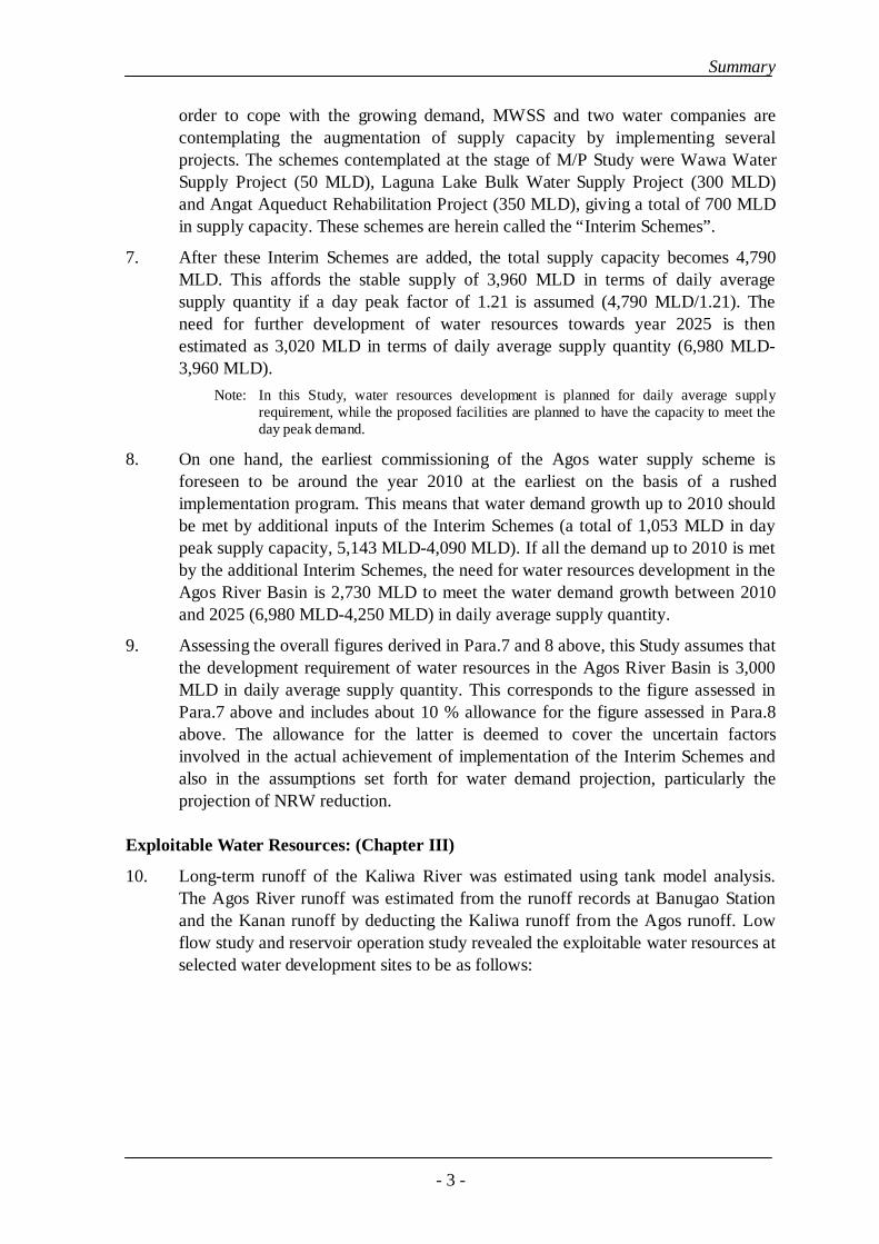
order to cope with the growing demand, MWSS and two water companies are contemplating the augmentation of supply capacity by implementing several projects. The schemes contemplated at the stage of M/P Study were Wawa Water Supply Project (50 MLD), Laguna Lake Bulk Water Supply Project (300 MLD) and Angat Aqueduct Rehabilitation Project (350 MLD), giving a total of 700 MLD in supply capacity. These schemes are herein called the “Interim Schemes”.
7. After these Interim Schemes are added, the total supply capacity becomes 4,790 MLD. This affords the stable supply of 3,960 MLD in terms of daily average supply quantity if a day peak factor of 1.21 is assumed (4,790 MLD/1.21). The need for further development of water resources towards year 2025 is then estimated as 3,020 MLD in terms of daily average supply quantity (6,980 MLD- 3,960 MLD).
Note: In this Study, water resources development is planned for daily average supply requirement, while the proposed facilities are planned to have the capacity to meet the day peak demand.
8. On one hand, the earliest commissioning of the Agos water supply scheme is foreseen to be around the year 2010 at the earliest on the basis of a rushed implementation program. This means that water demand growth up to 2010 should be met by additional inputs of the Interim Schemes (a total of 1,053 MLD in day peak supply capacity, 5,143 MLD-4,090 MLD). If all the demand up to 2010 is met by the additional Interim Schemes, the need for water resources development in the Agos River Basin is 2,730 MLD to meet the water demand growth between 2010 and 2025 (6,980 MLD-4,250 MLD) in daily average supply quantity.
9. Assessing the overall figures derived in Para.7 and 8 above, this Study assumes that the development requirement of water resources in the Agos River Basin is 3,000 MLD in daily average supply quantity. This corresponds to the figure assessed in Para.7 above and includes about 10 % allowance for the figure assessed in Para.8 above. The allowance for the latter is deemed to cover the uncertain factors involved in the actual achievement of implementation of the Interim Schemes and also in the assumptions set forth for water demand projection, particularly the projection of NRW reduction.
Exploitable Water Resources: (Chapter III)
10. Long-term runoff of the Kaliwa River was estimated using tank model analysis. The Agos River runoff was estimated from the runoff records at Banugao Station and the Kanan runoff by deducting the Kaliwa runoff from the Agos runoff. Low flow study and reservoir operation study revealed the exploitable water resources at selected water development sites to be as follows:

Summary
- 4 -
Exploitable Water Resources at Water Development Sites
Reservoir Water Level (EL. m)
Exploitable Water Resources
Water Resources Development Scheme
FSL MOL (MLD) (m3/sec)
Figures Assessed in Previous Study
Reservoir Scheme: Laiban Dam Kanan No.2 Dam Agos Dam Run-of-River Intake: Kaliwa Low Dam Laiban Low Dam Kanan Low Dam
270 310 310 159 - -
237 278 225 133
1,830 3,310 3,770 5,210
550 340 770
21.2 38.3 43.6 60.2
6.4 3.9 8.9
1,900 MLD at FSL 270 *1 3,170 MLD at FSL 295 *1 6,740 MLD at FSL 159 *2 8.6 m3/sec *2
Notes: (1) Reservoir Scheme: Design year is regarded to be a dry year occurring once in 10 years, roughly corresponding to a 97-98 % dependability for the whole period
(2) Run-of-River Scheme: 90 % dependable discharge, after releasing river maintenance discharge, which is taken at 10 % of 80 % discharge
(3) Exploitable water at Agos Dam represents the total yield usable for water supply and hydropower
*1 MWSP III Study *2 EDCOP Study
Geological Survey: (Chapter III)
11. Initial survey conducted during the M/P study identified the following geological issues to be taken into account in formulating the master plan:
(a) Seismicity due to proximity to the active Philippine Fault (Infanta Fault). This issue is common to all dam schemes
(b) The existence of many faults near the proposed damsites and along waterways, some of which are categorized by PHILVOLCS as assumed active fault. This issue is also common to all dam and waterway schemes, although the extent varies by scheme
(c) Concern for reservoir watertightness due to limestone masses occurring in the reservoir areas, for both the Laiban and Agos Dams
(d) Thick riverbed deposit at Agos Dam and potential landslide problems at both the Agos and Kanan No.2 Damsites
Initial Environmental Examination: (Chapter IV)
12. Initial environmental examination (IEE) has identified varying degrees of socio-environmental impacts that may arise due to the proposed projects. The major issues are as follows:
(a) Impact on the riverine environment in the downstream reaches due to reduction of flow caused by water transfer to Metro Manila and reduction of sediment discharges caused by construction of dams.
(b) Change of flow regime will force local people to change the way of river use. Of a more serious concern is the possible change of morphology of the river mouth and coastlines in the lowermost Infanta-General Nakar alluvial
Summary
- 5 -
plain, which would be especially serious in the case of Agos Dam being constructed.
(c) Need for watershed management, especially for the Kaliwa River basin
(d) Need for protection of ecosystems already being affected by illegal logging and human encroachment. This issue is particularly important in the Kanan-Agos watersheds.
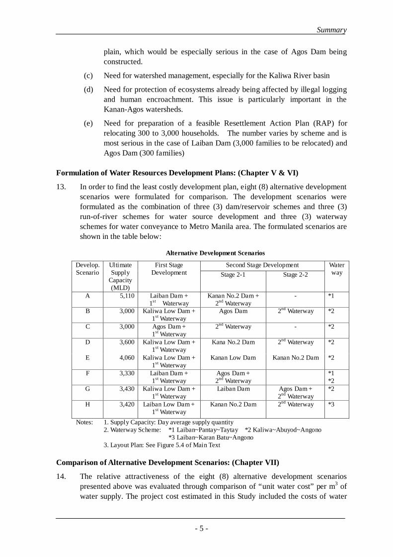
(e) Need for preparation of a feasible Resettlement Action Plan (RAP) for relocating 300 to 3,000 households. The number varies by scheme and is most serious in the case of Laiban Dam (3,000 families to be relocated) and Agos Dam (300 families)
Formulation of Water Resources Development Plans: (Chapter V & VI)
13. In order to find the least costly development plan, eight (8) alternative development scenarios were formulated for comparison. The development scenarios were formulated as the combination of three (3) dam/reservoir schemes and three (3) run-of-river schemes for water source development and three (3) waterway schemes for water conveyance to Metro Manila area. The formulated scenarios are shown in the table below:
Alternative Development Scenarios
Second Stage Development Develop. Scenario
Ultimate Supply
Capacity (MLD)
First Stage Development Stage 2-1 Stage 2-2
Waterway
A 5,110 Laiban Dam + 1st Waterway
Kanan No.2 Dam + 2nd Waterway
- *1
B 3,000 Kaliwa Low Dam + 1st Waterway
Agos Dam 2nd Waterway *2
C 3,000 Agos Dam + 1st Waterway
2nd Waterway - *2
D 3,600 Kaliwa Low Dam + 1st Waterway
Kana No.2 Dam 2nd Waterway *2
E 4,060 Kaliwa Low Dam + 1st Waterway
Kanan Low Dam Kanan No.2 Dam *2
F 3,330 Laiban Dam + 1st Waterway
Agos Dam + 2nd Waterway
*1 *2
G 3,430 Kaliwa Low Dam + 1st Waterway
Laiban Dam Agos Dam + 2nd Waterway
*2
H 3,420 Laiban Low Dam + 1st Waterway
Kanan No.2 Dam 2nd Waterway *3
Notes: 1. Supply Capacity: Day average supply quantity 2. Waterway Scheme: *1 Laiban~Pantay~Taytay *2 Kaliwa~Abuyod~Angono
*3 Laiban~Karan Batu~Angono 3. Layout Plan: See Figure 5.4 of Main Text
Comparison of Alternative Development Scenarios: (Chapter VII)
14. The relative attractiveness of the eight (8) alternative development scenarios presented above was evaluated through comparison of “unit water cost” per m3 of water supply. The project cost estimated in this Study included the costs of water

Summary
- 6 -
source exploitation (dam/reservoir), a water treatment plant and water conveyance facilities up to a main service reservoir planned at Taytay (Scenarios A and F) or Angono (Scenarios B to H). Hence, the water cost evaluated herein represents the cost at the main service reservoir, which is regarded as the off-take point for distribution to the supply network.
15. Since the proposed development scenarios are formulated to differ in their development scales, the comparison should take into account not only cost factor but also time factor. Hence, the “unit water cost” is calculated by comparing the present worth of total incurred costs and expected revenues by discounting to 2001 prices at a discount rate of 12 % per annum. It is assumed that a part of the invested cost is recovered by electricity energy revenue and the remainder should be recovered by water revenue. On this basis, a trial calculation was made to find a “unit water cost” that would equalize the present worth of the cost portion to be recovered by water revenue (the portion remaining after deducting the portion to be recovered by energy revenue) and the present worth of water revenue.
16. The evaluation horizon is set at 40 years after the first stage scheme is commissioned. Although the earliest attainable completion year of the first stage scheme varies by scenario from 2010 to 2013, the Study assumed that the first stage project of all the Scenarios would be completed in year 2010 to enable a comparison of the Scenarios within the same time frame. Therefore, the evaluation horizon assumed is from 2011 to 2050 in this comparative study.
17. The results of ‘unit water cost’ comparison are summarized in the table below:
Summary of Comparison of Unit Water Cost Index
Present Worth Project Cost *1
Water Volume Supplied
Cost to be Recovered
Equalizing Unit Water
Cost *2
Scenario Proposed Scheme
(US$ Mil.) (Mil. m3) (US$ Mil.) (US$/ m3) A Laiban + Kanan No.2 Dam 2,256 1,650 1,429 0.400 B Kaliwa Low Dam + Agos Dam 1,826 1,449 1,129 0.379 C Agos Dam 1,820 1,449 1,171 0.391 D Kaliwa Low Dam + Kanan No.2
Dam 1,884 1,531 1,248 0.389
E Kaliwa Low Dam + Kanan Low Dam + Kanan No.2 Dam
2,200 1,580 1,411 0.421
F Laiban Dam + Agos Dam 2,064 1,498 1,236 0.390 G Kaliwa Low Dam + Laiban Dam +
Agos Dam 2,284 1,513 1,337 0.424
H Laiban Low Dam + Kanan No.2 Dam
1,778 1,511 1,254 0.398
(For Reference) - Laiban Dam 871 1,166 868 0.380
Notes: *1 Base cost estimate at 2001 price, comprising construction cost, land acquisition/resettlement cost, engineering/administration cost (7%) and physical contingency (15%)
*2 Unit water cost at 2001 price, which equalizes the present worth of costs and the present worth of water sale amount, discounted at 12% per annum. The water sale price is escalated at 3% per annum.
Summary
- 7 -
18. As indicated in the table above, the unit water cost index is evaluated to be the least for Scenario B, followed by Scenarios C, D, F and H being at an almost equal level. The favorable index of Scenario B can be explained by the larger quantity of water exploitable by the Agos reservoir, which is usable either for water supply and hydropower, as indicated in the table shown in Para.10 above.
19. On one hand, the unit water cost index of the Laiban Dam project showed an index value almost comparable to that of Scenario B. Hence, this Study proposes that both the Scenario B (evaluated as least costly on scenario basis) and Laiban Dam (evaluated as attractive on an individual project basis) would be worthy of further consideration in formulation of the master development plan of the Agos River Basin.
Proposed Master Plan: (Chapter VIII)
20. A master plan was formulated basically in line with the plans proposed in Development Scenario B. The configuration of the proposed master plan is shown in Figure 8.1 of the main text. Water Supply Development Plan:
21. Scenario B envisages the development of Kaliwa Low Dam initially and Agos Dam ultimately for meeting water demand up to the year 2025 (3,000 MLD in daily average supply quantity). The sequence of proposed development is shown in the table below:
Sequence of Proposed Water Supply Development
2nd Stage Development Proposed Facilities
1st Stage Develop Stage 2-1 Stage 2-2
Water Supply Q’ty 550 MLD initially Additional 950 MLD Additional 1,500 MLD Kaliwa Low Dam Supply of 550 MLD
initially (Supply substituted by Agos Dam)
-
Agos Dam
- Supply of 1,500 MLD, including 550 MLD earlier supplied by Kaliwa Low Dam
Supply of additional 1,500 MLD
Waterways 1st Waterway for 1,500 MLD
- 2nd Waterway for additional 1,500 MLD
Water Treatment Plant (WTP)
WTP #1 – 750 MLD WTP #2 - 750 MLD WTP #3 & #4, each 750 MLD
Main Service Reservoir (SR)
SR #1 for 750 MLD SR #2 for 750 MLD SR #3&4 for additional 1,500 MLD
Note: The above figures in MLD represent daily average supply quantity. The capacity of waterway and WTP is planned to be 1.21 times the daily average supply capacity to meet the day peak demand.
22. As stated above, the Laiban Dam project was retained for consideration in the master plan. The project is already committed by the Memorandum Order No.10 of August 5, 1998, which mandated the MWSS to resume the implementation of the project.
23. There are two hurdles for the implementation of Laiban Dam. One is the resettlement of about 3,000 households or 15,000 people, which constitutes a large social problem. The other is the concern for possible delay in completion due to the

Summary
- 8 -
time requirement for solving the resettlement issue before construction and also potential problems that may arise during the construction. The implementation of Laiban Dam depends on MWSS’s confidence in how quickly the resettlement issue could be solved and how fast the project could be commissioned. Hydropower Development:
24. Three (3) potential hydropower development schemes are proposed in the master plan: (i) Abuyod power station at the downstream end of the water conveyance tunnel, (ii) Agos power station at the toe of Agos Dam, and (iii) Kanan No.2 power station at the toe of Kanan No.2 Dam. The proposed hydropower development is summarized in table below:
Summary of Hydropower Development Plan
Power Output (MW) Energy Production (GWh) Scheme Installed Capacity
95 % Guaranteed
Primary Energy
Secondary Energy
Total
Abuyod P/S *1 Agos P/S Kanan No.2 P/S *2
12.5 85.6
209.5
7.0 71.3
135.3
98.6 178.0 406.4
- 240.9 97.2
98.6 418.9 503.6
Notes: *1 Installed after the completion of Agos Dam and 2nd Waterway *2 Can be implemented independently from the water supply schemes
Measures for Mitigation of Socio-Environmental Issues:
25. The socio-environmental study (Chapter IV) has identified several potential issues to arise due to the proposed projects. These issues should be taken into account in the subsequent feasibility study.
(1) Impact to River Mouth Alluvial Plain due to Reduced Sediment Yield
A major impact of serious concern is, as stated in Para.12 above, the possible change morphology of river mouth and coastlines.
(2) Resettlement Scheme
The proposed water resources development and conveyance projects will require a varying degree of relocation of households. This issue is an important sociological parameter determining the viability of the proposed projects and hence is taken up as a planning element of the master plan.
(3) Watershed Management in the Kaliwa River Basin
The Kaliwa River Basin is yielding a large quantity of sediments due mainly to deforestation over a long period and active development of land for cultivation. Also, the destruction of forest cover results in wildlife habitat loss, and consequently diminishing biodiversity and wildlife.
The DENR-Forest Management Bureau (FMB) is currently implementing a Watershed Rehabilitation and Management Improvement Project for the Kaliwa catchment. Since the recovery of a fair watershed environment takes a relatively long period, the activities of Kaliwa Watershed Management Project should be further strengthened and continued henceforward.

Summary
- 9 -
(4) Conservation of Eco-Systems in Kanan-Agos Watershed
The Kanan and Agos River Basins are covered by thick vegetation. This vegetation cover is home to some migratory and permanent endangered fauna, such as the Philippine deer, wild pig, monitor lizard and kalaw. These species are important components in the stability and productivity of the ecosystem.
Extensive logging especially in the Kanan River watershed is already posing a serious threat to the primary forest in the upper catchment. Furthermore, the impoundment of the Agos reservoir and the construction of Kanan No.2 Dam (including the reservoir, access road and transmission line) will have significant impacts on the forest environment and ecological system in the basin. Projects for Enhancement of Regional Development:
26. The implementation of water resources development will cause various types of inconveniences to people in the project area, such as the relocation of settlements, change of river environments, disconnection of local communities due to reservoir impoundment, etc. For compensation for those inconveniences, the project will have to provide necessary measures to improve people’s livelihood and enhance regional economic activities. The following describe the outline of the projects proposed in this respect:
(1) Bank Erosion Protection Work in the Infanta-General Nakar Alluvial Plain
In the Infanta-General Nakar alluvial plain, severe bank erosion is taking place along the both banks of the Agos River. The erosion at the heaviest portion was as large as 300-400 m during 1952 and 1995. The bank has already been incised very close to the main part of the General Nakar town. According to people in the area and the Municipality Office, the most urgent project needed in this area is the protection of the banks from further erosion. The proposed work consists of revetment work coupled with the installation of groins in selected portions of the river course.
(2) Provision of Riverbank Structure for Facilitating the People’s River Use
The riverine environment downstream of the Agos Dam will change significantly, e.g. degradation of riverbed level, decrease of dry season flow, etc. This will cause the people in the area to change the ways of water use or river. The proposed project is to provide riverbank structures for facilitating the people’s use of the river at places where people use the river. The proposed structures are for boat landing and bathing/washing that will be usable at any river water level.
(3) Provision of Access Roads/Footpaths for the Communities
The resettlement scheme for the Agos Dam contemplates relocation of the existing settlements to lands at higher elevations in the vicinity of the original locations. The project being proposed herein is to provide access to those new resettlement areas by extending a road from the access roads built for the construction works. If the resettlement site is less populated or in a relatively remote location, access will be by footpath. In addition, a trunk footpath connecting Agos Dam, Kaliwa Low Dam

Summary
- 10 -
and Barangay Daraitan will be built. This footpath will facilitate the people’s access to shops, schools, medical facilities and other public facilities located in the vicinity. Also, for improving access to Barangay Daraitan during flood season, a footpath suspension bridge will be built just upstream of the existing ferry site.
(4) Establishment of a Manpower Training Center
Some of the PAFs (project affected families) will have to change their occupation due mainly to resettlement outside the present livelihood area. To support sustainable livelihood of the PAFs, a manpower training center will be established at Barangay Daraitan or new resettlement site.
(5) Establishment of a Health Center at Barangay Daraitan
In Barangay Daraitan, there are at present two health centers staffed by a nurse and a midwife, the latter visiting once a week, which is a lower level of service than is required for a medical facility in an area with a population in the order of 4,000. The proposed project is to build a health center equipped with the minimum equipment required and being staffed by a physician and a nurse.
(6) Power Supply to Infanta-General Nakar Area
The proposed master plan contemplates to supply the power generated at Agos Power Station to the Infanta-General Nakar area by a 69 kV transmission line. The stable supply of power will contribute to further development of economic activities in the area through stimulating industrial development.
Economic Evaluation of Proposed Schemes: (Chapter VIII)
27. Economic evaluation was made for two major schemes proposed in the master plan: one is the scheme comprised of Kaliwa Low Dam, Agos Dam and Kaliwa- Angono Waterway for multi-purpose development of water supply and hydropower. The other is Kanan No.2 Dam scheme for hydropower development. The economic benefit of water supply is regarded to be the willingness-to-pay for water. The hydropower benefit is regarded as the cost of alternative thermal power plant.
28. Analysis of the cost and benefit streams revealed that the economic internal rate of return (EIRR) is 13.5 % for the former multi-purpose scheme and 5.4 % for the Kanan No.2 hydropower scheme. The EIRR evaluated for the Kanan No. 2 scheme is relatively low. The Kanan No.2 scheme will require a further elaboration of the plans for justifying the viability.
Proposed Implementation Organizations: (Chapters VIII & X)
29. The Steering Committee meeting for this Study, held on August 21, 2001, agreed that “MWSS will handle the implementation of the water resources development of the Agos River Basin until such time that a River Basin Authority is created”. The Study assumes that MWSS would act as the Executing Agency for the proposed project.

Summary
- 11 -
30. In order to assist and coordinate the roles and duties of the MWSS, an “Inter-Agency Coordinating Committee” will be organized. The Committee will be composed of representatives from NEDA, DPWH, DENR, DILG, DOE/NPC, NWRB, NIA, MWSS, and Quezon and Rizal Province. MWSS will chair the Committee. Chapter X of the main text describes the detail of the roles and functions of the Committee and also the proposed organizational structure in the operation and maintenance stage.
Proposed Financial Arrangement: (Chapter VIII)
31. This Study proposes the following procurement approaches to be most advantageous to the project:
(1) Project under BOT (Build-Operate-and-Transfer) Scheme:
In line with the policy of the Government as well as that of the MWSS, a basic principle would be to procure the work through the maximum use of private financing resources (e.g. BOT). This procurement will be applied to the following work components:
• Water treatment plant and conveyance facilities (from water treatment plant up to service reservoirs)
• Distribution mains (preferably to be implemented by the present water distribution concessionaires)
• Hydropower plants at Abuyod and Agos Dam (2) Projects under Government Project
On the other hand, construction of the water resources facilities (dam and tunnel) involves greater technical risks and requires a large investment cost, which would be a large burden to most BOT Proponents. The least costly approach is to build the water resources facilities as a government project by utilizing the ODA soft loans of a low interest rate longer repayment period, which affords minimizing the annual costs and accordingly minimizing the water cost. The work components proposed for the implementation as a government project include:
• Water source development, i.e. Kaliwa Low Dam and Agos dam • Water conveyance tunnel up to Abuyod hydropower plant • Projects proposed for regional development (See Para.27 above)
The fund for repayment of loans can be generated from the sale of raw water to the BOT concessionaires for water supply and electricity supply.
Summary
- 12 -
Selection of Project for Subsequent Feasibility Study: (Chapter IX)
32. Among the projects included in the proposed master plan (Para.20 to 27 above), the most urgent project is water supply development for attaining the earliest supply of water to Metro Manila. Hence, the subsequent feasibility study will take up the 1st stage development of the water supply schemes proposed in Development Scenario B, which is outlined in the table shown in Para.21 above.
33. The 1st stage project consists of the Kaliwa Low Dam with the 1st waterway. A matter to be noted is that the viability of the 1st stage project relies largely on the feasibility of the Agos Dam. Therefore, the feasibility study should also include the investigation and studies of the Agos Dam as well.

i
THE STUDY ON
WATER RESOURCES DEVELOPMENT FOR
METRO MANILA IN
THE REPUBLIC OF THE PHILIPPINES
FINAL REPORT
VOLUME II PHASE 1: MASTER PLAN STUDY
MAIN REPORT
Table of Contents
Location Map of the Study Area Abbreviations Measurements
Page CHAPTER I INTRODUCTION ................................................................................. 1-1
1.1 General ............................................................................................................. 1-1 1.1.1 Background ............................................................................................ 1-1 1.1.2 Objectives of the Study .......................................................................... 1-2 1.1.3 Study Area.............................................................................................. 1-2 1.1.4 Overall Work Schedule of the Study...................................................... 1-2
1.2 Progress of Phase I Study................................................................................... 1-3 1.2.1 Activities during the First Field Investigat
August 2001) ...................................................................................... 1-3 ion Stage (March-
1.2.2 Supporting Works Undertaken by NWRB........................................... 1-4 1.2.3 First Home Office Work (September-November 2001)....................... 1-4
1.3 Master Plan Study Reports................................................................................. 1-5 1.4 Necessity of Water Resources Development in the Agos River Basin ............ 1-5
1.4.1 General ................................................................................................. 1-5 1.4.2 Present Situation of Water Demand and Supply Balance in Metro
Manila ................................................................................................ 1-6 1.4.3 National Policy of Expansion of Water Supply Capacity for
Metro Manila........................................................................................ 1-7 1.4.4 Prioritized Water Supply Projects for Metro Manila in Previous
Studies .................................................................................................. 1-7 1.4.5 Interim Water Supply Schemes Contemplated by MWSS................... 1-9 1.4.6 Necessity of Agos Water Resources to Meet Water Demand of
Metro Manila........................................................................................ 1-9

ii
CHAPTER II SCIO-ECONOMIC FRAMEWORK OF STUDY AREA AND WATER DEMAND PROJECTION ..................................................... 2-1
2.1 Present Socio-Economic Conditions of the Study Area ................................... 2-1 2.1.1 Current Status of Socio-Economy in the Philippines........................... 2-1 2.1.2 Profiles of Region, Province and Municipality.................................... 2-2
2.2 National Economic Development Plan ............................................................ 2-2 2.2.1 Long-term Philippines Development Plan (LTPDP) ........................... 2-2 2.2.2 Medium-term Philippines Development Plan (MTPDP)..................... 2-2
2.3 Socio-Economic Projection .............................................................................. 2-3 2.3.1 Population Projection ......................................................................... 2-3 2.3.2 GRDP Projection.................................................................................. 2-5
2.4 Current Situation of Water Supply in Metro Manila ........................................ 2-8 2.4.1 Privatization of MWSS and Present Situation of Water Supply .......... 2-8 2.4.2 Service Area and Population Served .................................................... 2-8 2.4.3 Existing Water Supply Facilities .......................................................... 2-9 2.4.4 Current Water Production and Billed Water....................................... 2-11 2.4.5 Water Tariff in MWSS’s Service Area ............................................... 2-13
2.5 Water Demand Projection for Metro Manila .................................................. 2-13 2.5.1 Domestic Water Demand ................................................................... 2-13 2.5.2 Commercial Water Demand............................................................... 2-16 2.5.3 Industrial Water Demand ................................................................... 2-16 2.5.4 Total Water Demand........................................................................... 2-17 2.5.5 Comparison with Previous Water Demand Projections ..................... 2-18
2.6 Water to be Exploited in the Agos River Basin to Meet Water Demand of MWSS’s Service Area .................................................................................... 2-19 2.6.1 Interim Water Supply Projects Envisaged by MWSS........................ 2-19 2.6.2 Water Demand and Supply Balance Until 2025................................. 2-20 2.6.3 Water to be Exploited in the Agos River Basin to Meet Water
Demand up to 2025 ............................................................................ 2-21 2.7 Recommended Measures to Reduce Non-Revenue Water Ratio ..................... 2-21
2.7.1 Field Survey to Clarify Water Leakage.............................................. 2-21 2.7.2 Recommended Rehabilitation Works for Reducing Water
Leakage .............................................................................................. 2-21 2.7.3 Water Tariff Collection System on a Community Basis .................... 2-22
2.8 Present Condition of Power Market................................................................. 2-22 2.8.1 Power Sector in the Philippines ....................................................... 2-22 2.8.2 Power Development Program by NPC .............................................. 2-23
CHAPTER III THE AGOS RIVER BASIN ................................................................ 3-1 3.1 Geography and Topography ............................................................................. 3-1
3.1.1 Geography ............................................................................................ 3-1 3.1.2 Topographic Data Available for Master Plan Study............................. 3-2
iii
3.2 Meteorology and Hydrology ............................................................................ 3-3 3.2.1 Available Data .................................................................................... 3-3 3.2.2 Hydrological Investigation Works Performed during the Master
Plan Stage............................................................................................. 3-4 3.2.3 Meteorology ......................................................................................... 3-5 3.2.4 Runoff Analysis.................................................................................... 3-5 3.2.5 Flood Study .......................................................................................... 3-7 3.2.6 Sediment Study .................................................................................... 3-8
3.3 River Water Quality ......................................................................................... 3-9 3.3.1 Previous Water Quality Analysis.......................................................... 3-9 3.3.2 Water Quality Analyses Carried out in the First Field
Investigation Works.............................................................................. 3-9 3.3.3 Matters to be Considered in Design of Water Treatment Facility
in Relation to River Water Quality..................................................... 3-10 3.4 Geology .......................................................................................................... 3-10
3.4.1 Regional Geology............................................................................... 3-10 3.4.2 Faults .................................................................................................. 3-11 3.4.3 Seismicity........................................................................................... 3-11 3.4.4 Geotechnical Evaluation of Respective Schemes .............................. 3-11 3.4.5 Construction Materials ....................................................................... 3-20
3.5 Water Demand and Supply for Lowermost Reach of the Agos ....................... 3-22 3.5.1 Present Condition of Water Supply for Lowermost Reach of the
Agos ................................................................................................... 3-23 3.5.2 Future Water Demand and Availability of Water Source ................... 3-23
3.6 Flood Damages in Lowermost Reach of the Agos........................................... 3-24 3.6.1 General ............................................................................................... 3-24 3.6.2 Major Typhoon Records and Flood Damage Records ....................... 3-24 3.6.3 Present Condition............................................................................... 3-25
CHAPTER IV INITIAL ENVIRONMENTAL ASSESSMENT.................................... 4-1
4.1 General ............................................................................................................... 4-1 4.2 Environmental Legal Framework Relevant to the Project ............................... 4-1
4.2.1 Environmental Legal Framework in the Philippines ........................... 4-1 4.2.2 Environmental Regulatory Standards and Other Laws Relevant
to the Study .......................................................................................... 4-2 4.2.3 Legal Framework for Resettlement and Indigenous People ................ 4-4
4.3 Environmental Survey Works Carried Out in First Field Investigation Period ................................................................................................................. 4-5 4.3.1 Site Reconnaissance............................................................................. 4-5 4.3.2 Review of Previous Studies and Meeting with Agencies and
Communities Concerned...................................................................... 4-6 4.3.3 Initial Environmental Examination (IEE) ............................................ 4-6
iv
4.4 Overview of Environmental Conditions in the Study Area ............................... 4-7 4.4.1 General Environmental Conditions...................................................... 4-7 4.4.2 Findings from IEE Survey ................................................................... 4-7
4.5 Environmental Features Particular to Each River Basin.................................... 4-9 4.5.1 Kaliwa River Basin .............................................................................. 4-9 4.5.2 Kanan River Basin ............................................................................. 4-15 4.5.3 Agos River Basin ............................................................................... 4-16 4.5.4 Agos Lower Basin.............................................................................. 4-17 4.5.5 Coastal Areas of Infanta/General Nakar ............................................ 4-18
4.6 Resettlement Issues .......................................................................................... 4-19 4.6.1 General ............................................................................................... 4-19 4.6.2 Resettlement Requirement of Respective Development Schemes..... 4-20 4.6.3 Proposed Resettlement Plans ............................................................. 4-28
4.7 Summary of Environmental and Resettlement Problems by Scheme.............. 4-32 CHAPTER V WATER RESOURCES DEVELOPMENT PLAN IN THE AGOS
RIVER BASIN ..................................................................................... 5-1 5.1 Basic Framework of Plan Formulation ............................................................ 5-1
5.1.1 General ................................................................................................. 5-1 5.1.2 Development Scale for Meeting Water Demand up to Year 2025 ....... 5-1 5.1.3 Formulation of Water Resources Development Plans in the Agos
River Basin........................................................................................... 5-3 5.2 Background and Development Concepts of Water Source Development
Schemes in the Agos River Basin ...................................................................... 5-4 5.2.1 Laiban Dam on the Kaliwa River......................................................... 5-4 5.2.2 Kanan No.2 Dam on the Kanan River ................................................. 5-4 5.2.3 Agos Dam on Agos Mainstream .......................................................... 5-5 5.2.4 Kaliwa Low Dam on the Kaliwa River................................................ 5-5 5.2.5 Laiban Low Dam on the Kaliwa River ................................................ 5-6 5.2.6 Kanan Low Dam on the Kanan River.................................................. 5-6
5.3 Optimization of Reservoir Type Schemes.......................................................... 5-7 5.3.1 Selection of Optimum Full Supply Water Level (FSL) ....................... 5-7 5.3.2 Selection of Dam Type......................................................................... 5-8
5.4 Formulation of Alternative Development Scenarios ........................................ 5-8 5.4.1 Water Balance Study ............................................................................ 5-8 5.4.2 Exploitable Water Resources at Each Water Source Development
Site........................................................................................................ 5-9 5.4.3 Formulation of Alternative Development Scenarios.......................... 5-10
5.5 Main Features of Eight (8) Alternative Development Scenarios to Meet Water Demands of Metro Manila until Year 2025 ........................................... 5-11 5.5.1 Alternative Development Scenario A (Laiban Dam + Kanan No.2
Dam) ................................................................................................. 5-11

v
5.5.2 Alternative Development Scenario B (Kaliwa Low Dam + Agos Dam) ................................................................................................. 5-11
5.5.3 Alternative Development Scenario C (Agos Dam without Kaliwa Low Dam) ........................................................................................ 5-12
5.5.4 Alternative Development Scenario D (Kaliwa Low Dam + Kanan No.2 Dam) ............................................................................ 5-12
5.5.5 Alternative Development Scenario E (Kaliwa Low Dam + Kanan Low Dam + Kanan No.2 Dam) ........................................................ 5-13
5.5.6 Alternative Development Scenario F (Laiban Dam + Agos Dam) ............................................................................................................ 5-14
5.5.7 Alternative Development Scenario G (Kaliwa Low Dam + Laiban Dam + Agos Dam) ............................................................... 5-14
5.5.8 Alternative Development Scenario H (Laiban Low Dam + Kanan No.2 Dam) ........................................................................................ 5-14
5.6 Future Developments in Each Development Scenario..................................... 5-15 5.6.1 Plan A-3: Additional Development Plan (Agos Dam) .................... 5-15 5.6.2 Plan B-3: Additional Development Plan (Laiban Dam and
Kanan No.2 Dam) .............................................................................. 5-16 5.6.3 Plan C-3: Development Plan of 3rd Stage Onward ........................ 5-16 5.6.4 Plan D-3: Development Plan of 3rd Stage Onward ........................ 5-16 5.6.5 Plan E-3: Development Plan of 3rd Stage Onward......................... 5-16 5.6.6 Plan F-3: Development Plan of 3rd Stage Onward ......................... 5-17 5.6.7 Plan G-3: Development Plan of 3rd Stage Onward ........................ 5-17 5.6.8 Plan H-3: Development Plan of 3rd Stage Onward ........................ 5-17
5.7 Hydropower Development Potentials in Each Development Scenario............ 5-17
CHAPTER VI WATER CONVEYANCE AND TREATMENT PLANT ...................... 6-1 6.1 Alternative Water Conveyance Routes Identified ............................................ 6-1
6.1.1 General ................................................................................................. 6-1 6.1.2 Laiban-Taytay Water Conveyance Route for Laiban High Dam ......... 6-1 6.1.3 Alternative Water Conveyance Routes for Kaliwa Low Dam and
Agos Dam............................................................................................. 6-1 6.1.4 Laiban-Angono Water Conveyance Route for Laiban Low Dam........ 6-2
6.2 Selection of Least Costly Route for Kaliwa-Angono Waterway ..................... 6-2 6.3 Water Conveyance Facilities and Treatment Plant for Selected Kaliwa-
Angono Water Conveyance Route ................................................................... 6-3 6.3.1 Water Conveyance Facilities ................................................................ 6-3 6.3.2 Hydraulic Conditions ........................................................................... 6-4 6.3.3 Water Treatment Facility...................................................................... 6-4 6.3.4 Treated Water Conveyance and Delivery Facilities ............................. 6-5
6.4 Preliminary Plan of Distribution Trunk Mains in MWSS’s Service Area ......... 6-7 6.4.1 Existing Distribution Trunk Mains....................................................... 6-7 6.4.2 Preliminary Plan of New Distribution Trunk Mains ............................ 6-8 6.4.3 Preliminary Cost Estimate of New Distribution Trunk Mains............. 6-9

vi
CHAPTER VII COMPARISON ON PRIORITY OF ALTERNATIVE
DEVELOPMENT SCHEMES............................................................... 7-1 7.1 General ............................................................................................................. 7-1 7.2 Preliminary Design of Proposed Structures ....................................................... 7-1
7.2.1 Dam in Reservoir Type Scheme........................................................... 7-1 7.2.2 Low Dam in Run-of-River Scheme ..................................................... 7-2 7.2.3 Waterways............................................................................................ 7-3
7.3 Preliminary Cost Estimate and Implementation Schedule ............................... 7-4 7.3.1 Preliminary Cost Estimate for Each Development Scenario ............... 7-4 7.3.2 Implementation Schedule..................................................................... 7-6
7.4 Comparison of Alternative Development Scenarios in Terms of Unit Water Cost Index................................................................................................ 7-7 7.4.1 Methodology and Procedure Adopted.................................................. 7-7 7.4.2 Comparison of Indexes on the Basis of Same Time-Fame .................. 7-9 7.4.3 Evaluation of Indexes on the Basis of Assumed Implementation
Schedule ............................................................................................. 7-10 7.4.4 Evaluation of Indexes on the Basis of Assumed Implementation
Schedule with Consideration of Penalty for Delay in Completion .... 7-11 7.4.5 Conclusion of Unit Water Cost Comparison...................................... 7-11
7.5 Technical Assessment of Development Scenario B ......................................... 7-11 7.5.1 Overall Technical Comparison with Other Scenarios ........................ 7-11 7.5.2 Water Resources Potential Exploitable for Water Demand After
Year 2025 ........................................................................................... 7-14 CHAPTER VIII FORMULATION OF MASTER PLAN ................................................ 8-1
8.1 General ............................................................................................................... 8-1 8.2 Water Supply Development toward Year 2025.................................................. 8-1
8.2.1 Configuration of Proposed Development Plans................................... 8-1 8.2.2 Kaliwa Low Dam ................................................................................. 8-2 8.2.3 Agos Dam............................................................................................. 8-3 8.2.4 Kaliwa-Angono Waterway................................................................... 8-3 8.2.5 Abuyod Water Treatment Plant ............................................................ 8-4 8.2.6 Angono (Taytay) and Antipolo Service Reservoirs ............................. 8-4 8.2.7 Distribution Mains ............................................................................... 8-5
8.3 Hydropower Development ................................................................................. 8-5 8.3.1 Abuyod Power Station ......................................................................... 8-5 8.3.2 Agos Power Station.............................................................................. 8-6
8.4 Measures for Mitigation of Socio-Environmental Issues................................... 8-6 8.4.1 Reduced Sediment Yield at Agos River Mouth ................................... 8-6 8.4.2 Resettlement Schemes.......................................................................... 8-7 8.4.3 Watershed Management in Kaliwa River Basin .................................. 8-8 8.4.4 Conservation of Eco-System in Kanan-Agos Watershed..................... 8-9

vii
8.5 Projects for Enhancement of Regional Development ........................................ 8-9 8.5.1 Bank Erosion Protection Work in the Infanta-General Nakar
Alluvial Plain ..................................................................................... 8-10 8.5.2 Provision of Riverine Facilities.......................................................... 8-10 8.5.3 Provision of Access Roads/Footpaths for the Communities .............. 8-10 8.5.4 Establishment of a Vocational Training Center at Barangay
Daraitan.............................................................................................. 8-10 8.5.5 Establishment of a Medical Clinic at Barangay Daraitan .................. 8-11 8.5.6 Power Supply to Infanta-General Nakar Area ................................... 8-11
8.6 Optional Development Plan ............................................................................. 8-11 8.6.1 Option of Laiban Dam Development for Water Supply
Development ...................................................................................... 8-11 8.6.2 Options of Hydropower Development ............................................... 8-12 8.6.3 Resettlement Issues in Optional Development Plan .......................... 8-13
8.7 Implementation Schedule of Master Plan ........................................................ 8-15 8.8 Proposed Implementation Organizations ......................................................... 8-15 8.9 Proposed Financial Arrangement ..................................................................... 8-16
8.9.1 Procurement of Works........................................................................ 8-16 8.9.2 Financing for the Government-initiated Portion................................ 8-17 8.9.3 Financing and Procurement Method for BOT Portion....................... 8-17 8.9.4 Risks Factors in Financing for the Project ......................................... 8-18
8.10 Economic Evaluation of the Master Plan......................................................... 8-20 8.10.1 General ............................................................................................... 8-20 8.10.2 Conditions and Assumptions.............................................................. 8-20 8.10.3 Derivation of Economic Cost ............................................................. 8-21 8.10.4 Estimate of Economic Benefit ........................................................... 8-21 8.10.5 Computation of EIRR ........................................................................ 8-23
8.11 Technical and Social Aspects ........................................................................... 8-23 CHAPTER IX PRIORITY PROJECT FOR FEASIBILITY STUDY ........................... 9-1
9.1 Selection of Priority Project for Feasibility Study ............................................. 9-1 9.2 Components of the Project for the Feasibility Study ......................................... 9-1 9.3 Major Issues to be Examined in the Feasibility Study ....................................... 9-2
9.3.1 Hydrological Investigation................................................................... 9-2 9.3.2 Geological Investigation ...................................................................... 9-2 9.3.3 Socio-Environmental Investigation...................................................... 9-3 9.3.4 Plan Formulation and Design Aspects ................................................. 9-3 9.3.5 Projects for Regional Development ..................................................... 9-4
CHAPTER X ORGANIZATIONAL AND INSTITUTIONAL ASPECTS................ 10-1 10.1 Introduction...................................................................................................... 10-1 10.2 Current Organization/institution concerned with Water Resources
Development for Metro Manila Water Supply................................................. 10-1

viii
10.2.1 Key Agencies related to Metro Manila Water Supply........................ 10-1 10.2.2 Ambiguity of Responsibilities among Water-related Agencies ......... 10-6
10.3 Organizational Structure for Implementation of Agos Project......................... 10-7 10.3.1 Decision of Steering Committee Meeting.......................................... 10-7 10.3.2 Implementing Framework .................................................................. 10-7
10.4 Organizational Structure for Operation and Management after Completion... 10-8 10.4.1 Creation of Agos River Basin Committee.......................................... 10-8 10.4.2 Rationale for creation of ARBC......................................................... 10-9 10.4.3 Relationship between ARBC and River Basin Authority ................ 10-10
10.5 Recommendation for Water Resources Sector Reform.................................. 10-10
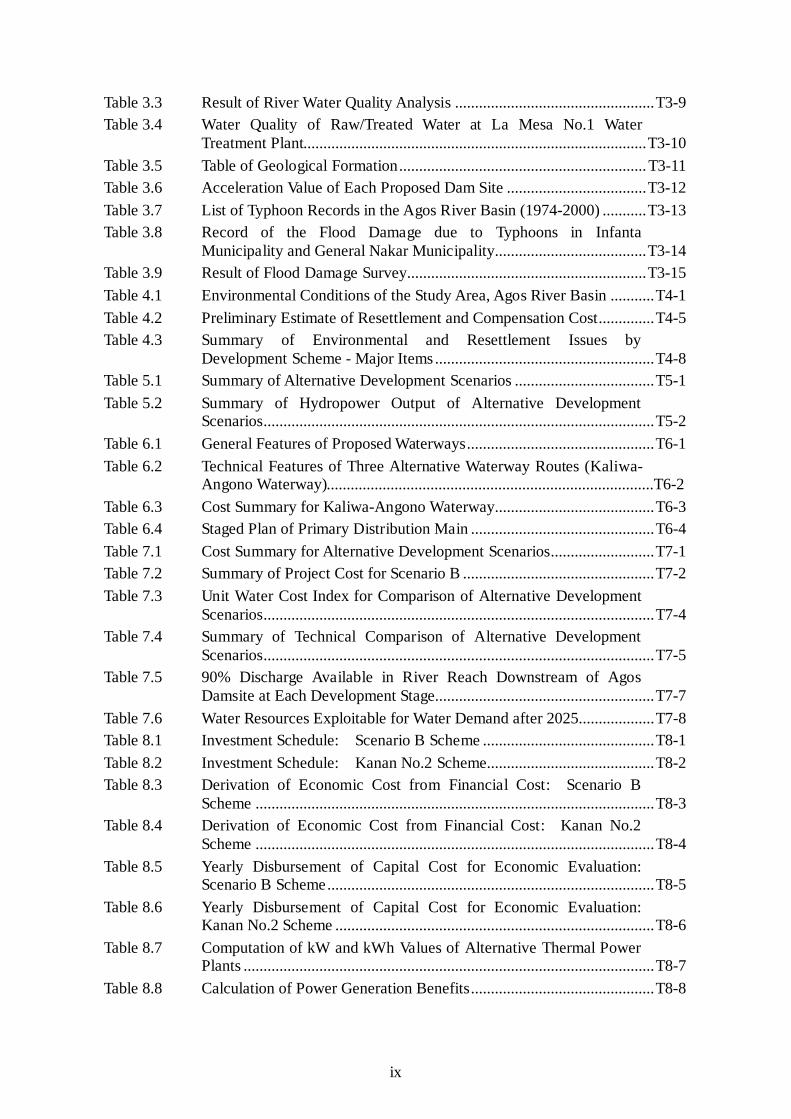
List of Tables Page
Table 1.1 Members of Steering Committee.............................................................T1-1 Table 1.2 Members of Technical Working Group ...................................................T1-2 Table 1.3 Counterpart Personnel of NWRB............................................................T1-3 Table 1.4 Comparison of Water Sources in and around Metro Manila in Study
of MWSP III, 1979 ..................................................................................T1-4 Table 2.1 Comparison of Socio-Economic Indices in the Study Area ....................T2-1 Table 2.2 Growth Target under Philippine National Development Plan.................T2-2 Table 2.3 Growth Target under Medium-term Philippines Development Plan,
1999-2004................................................................................................T2-3 Table 2.4 Present Service Coverage by City/Municipality (CY 2000) ...................T2-4 Table 2.5 Water Production and Distribution, MWCI.............................................T2-5 Table 2.6 Water Production and Distribution, MWSI .............................................T2-6 Table 2.7 Past Trend of Water Volume ....................................................................T2-7 Table 2.8 Assumed Share of Water Consumption by City/Municipality (CY
2000)........................................................................................................T2-8 Table 2.9 Proposed Per Capita Consumption..........................................................T2-9 Table 2.10 Proposed Service Coverage...................................................................T2-10 Table 2.11 Projected Population Served..................................................................T2-11 Table 2.12 Projected Water Demand by City/Municipality for Year 2005 .............T2-12 Table 2.13 Projected Water Demand by City/Municipality for Year 2010 .............T2-13 Table 2.14 Projected Water Demand by City/Municipality for Year 2015 .............T2-14 Table 2.15 Projected Water Demand by City/Municipality for Year 2020 .............T2-15 Table 2.16 Projected Water Demand by City/Municipality for Year 2025 .............T2-16 Table 2.17 Energy Sales and Peak Power Demand in 2000 Power Development
Program .................................................................................................T2-17 Table 2.18 System Capacity Addition –2000 Power Development Program..........T2-18 Table 2.19 Meralco System – Operating Statistics..................................................T2-19 Table 3.1 Estimated Mean Monthly Discharge .....................................................T3-1 Table 3.2 Flow Duration Curve...............................................................................T3-6
ix
Table 3.3 Result of River Water Quality Analysis ..................................................T3-9 Table 3.4 Water Quality of Raw/Treated Water at La Mesa No.1 Water
Treatment Plant......................................................................................T3-10 Table 3.5 Table of Geological Formation..............................................................T3-11 Table 3.6 Acceleration Value of Each Proposed Dam Site ...................................T3-12 Table 3.7 List of Typhoon Records in the Agos River Basin (1974-2000) ...........T3-13 Table 3.8 Record of the Flood Damage due to Typhoons in Infanta
Municipality and General Nakar Municipality......................................T3-14 Table 3.9 Result of Flood Damage Survey............................................................T3-15 Table 4.1 Environmental Conditions of the Study Area, Agos River Basin ...........T4-1 Table 4.2 Preliminary Estimate of Resettlement and Compensation Cost..............T4-5 Table 4.3 Summary of Environmental and Resettlement Issues by
Development Scheme - Major Items .......................................................T4-8 Table 5.1 Summary of Alternative Development Scenarios ...................................T5-1 Table 5.2 Summary of Hydropower Output of Alternative Development
Scenarios..................................................................................................T5-2 Table 6.1 General Features of Proposed Waterways...............................................T6-1 Table 6.2 Technical Features of Three Alternative Waterway Routes (Kaliwa-
Angono Waterway)..................................................................................T6-2 Table 6.3 Cost Summary for Kaliwa-Angono Waterway........................................T6-3 Table 6.4 Staged Plan of Primary Distribution Main ..............................................T6-4 Table 7.1 Cost Summary for Alternative Development Scenarios..........................T7-1 Table 7.2 Summary of Project Cost for Scenario B ................................................T7-2 Table 7.3 Unit Water Cost Index for Comparison of Alternative Development
Scenarios..................................................................................................T7-4 Table 7.4 Summary of Technical Comparison of Alternative Development
Scenarios..................................................................................................T7-5 Table 7.5 90% Discharge Available in River Reach Downstream of Agos
Damsite at Each Development Stage.......................................................T7-7 Table 7.6 Water Resources Exploitable for Water Demand after 2025...................T7-8 Table 8.1 Investment Schedule: Scenario B Scheme ...........................................T8-1 Table 8.2 Investment Schedule: Kanan No.2 Scheme..........................................T8-2 Table 8.3 Derivation of Economic Cost from Financial Cost: Scenario B
Scheme ....................................................................................................T8-3 Table 8.4 Derivation of Economic Cost from Financial Cost: Kanan No.2
Scheme ....................................................................................................T8-4 Table 8.5 Yearly Disbursement of Capital Cost for Economic Evaluation:
Scenario B Scheme..................................................................................T8-5 Table 8.6 Yearly Disbursement of Capital Cost for Economic Evaluation:
Kanan No.2 Scheme ................................................................................T8-6 Table 8.7 Computation of kW and kWh Values of Alternative Thermal Power
Plants .......................................................................................................T8-7 Table 8.8 Calculation of Power Generation Benefits..............................................T8-8

x
Table 8.9 Computation of Economic Internal Rate of Return (EIRR): Scenario B Scheme..................................................................................T8-9
Table 8.10 Computation of EIRR: Kanan No.2 Hydropower Station Scheme ....T8-10 Table 10.1 Key Organizations concerned with Metro Manila Water Supply..........T10-1
List of Figures
Page Figure 1.1 Water Resources Potential Area to Metro Manila ................................... F1-1 Figure 2.1 Service Area of MWCI and MWSI ......................................................... F2-1 Figure 2.2 Schematic Diagram of MWSS Headworks ............................................. F2-2 Figure 2.3 Major Interconnection Projects ............................................................... F2-3 Figure 3.1 Location Map of Hydrological Stations .................................................. F3-1 Figure 3.2 Available Hydrological Data ................................................................... F3-2 Figure 3.3 Regional Geological Map........................................................................ F3-3 Figure 3.4 Distribution of Active Faults in Southern Luzon .................................... F3-4 Figure 3.5 Philippine Significant Earthquakes (1608-1996) .................................... F3-5 Figure 3.6 Distribution of Faults around the Project Area (1).................................. F3-6 Figure 3.7 Distribution of Faults around the Project Area (2).................................. F3-7 Figure 3.8 Distribution of Limestone and Young Sediments around Agos~
Laiban Reservoir Area............................................................................. F3-8 Figure 3.9 Profile of Laiban Dam Axis..................................................................... F3-9 Figure 3.10 Profile Sketch of Kaliwa Low Dam No.2 Site ...................................... F3-10 Figure 3.11 Profile of Agos Dam Axis...................................................................... F3-11 Figure 3.12 Assumed Geological Profile of Mt. Daraitan~Pagus .......................... F3-12 Figure 3.13 Profile of Kanan No.2 Dam Axis .......................................................... F3-13 Figure 3.14 Geological Profile of Kaliwa-Abuyod Transfer Tunnel (Upstream
Part of Kaliwa-Angono Waterway) ....................................................... F3-14 Figure 3.15 Geological Profile of Laiban-Tanay Transfer Tunnel (Upstream Part
of Laiban-Angono Waterway)............................................................... F3-15 Figure 3.16 Comparison of Coastlines and River Channels of Infanta Peninsula
in 1952 and 1995 ................................................................................... F3-16 Figure 3.17 River Conditions of the Lower Agos..................................................... F3-17 Figure 4.1 Potential Damsites and Water Conveyance Routes and Land
Status/Regulatory of the Study Area ....................................................... F4-1 Figure 4.2 Project Affected Area .............................................................................. F4-2 Figure 5.1 Proposed Dam Development Sites in the Agos River Basin ................... F5-1 Figure 5.2 Comparison of Unit Cost of Water Resources Development for
Dams Planned in the Agos River Basin................................................... F5-2 Figure 5.3 General Layout of Development Plans.................................................... F5-3 Figure 5.4 Alternative Development Scenario A...................................................... F5-4 Figure 5.5 Alternative Development Scenario B...................................................... F5-5 Figure 5.6 Alternative Development Scenario C...................................................... F5-6
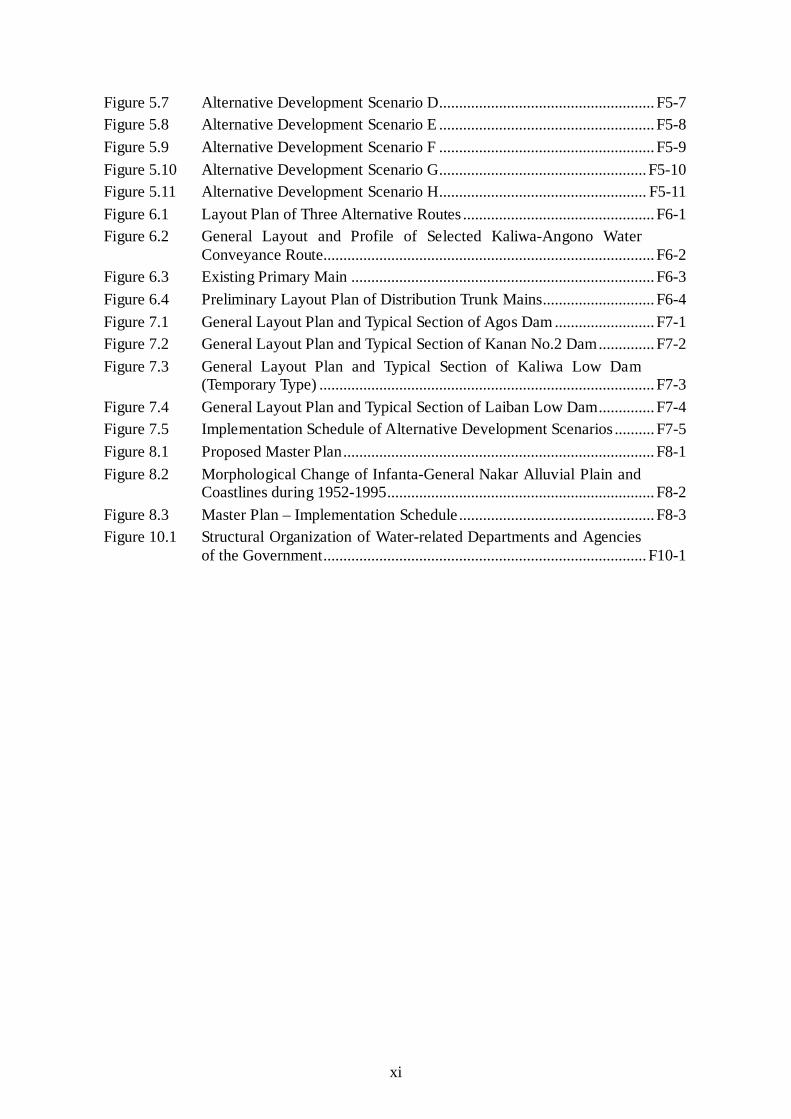
xi
Figure 5.7 Alternative Development Scenario D...................................................... F5-7 Figure 5.8 Alternative Development Scenario E ...................................................... F5-8 Figure 5.9 Alternative Development Scenario F ...................................................... F5-9 Figure 5.10 Alternative Development Scenario G.................................................... F5-10 Figure 5.11 Alternative Development Scenario H.................................................... F5-11 Figure 6.1 Layout Plan of Three Alternative Routes ................................................ F6-1 Figure 6.2 General Layout and Profile of Selected Kaliwa-Angono Water
Conveyance Route................................................................................... F6-2 Figure 6.3 Existing Primary Main ............................................................................ F6-3 Figure 6.4 Preliminary Layout Plan of Distribution Trunk Mains............................ F6-4 Figure 7.1 General Layout Plan and Typical Section of Agos Dam ......................... F7-1 Figure 7.2 General Layout Plan and Typical Section of Kanan No.2 Dam.............. F7-2 Figure 7.3 General Layout Plan and Typical Section of Kaliwa Low Dam
(Temporary Type) .................................................................................... F7-3 Figure 7.4 General Layout Plan and Typical Section of Laiban Low Dam.............. F7-4 Figure 7.5 Implementation Schedule of Alternative Development Scenarios .......... F7-5 Figure 8.1 Proposed Master Plan.............................................................................. F8-1 Figure 8.2 Morphological Change of Infanta-General Nakar Alluvial Plain and
Coastlines during 1952-1995................................................................... F8-2 Figure 8.3 Master Plan – Implementation Schedule................................................. F8-3 Figure 10.1 Structural Organization of Water-related Departments and Agencies
of the Government................................................................................. F10-1
xii
ABBREVIATION ACP : Asbestos Cement Pipe ADB : Asian Development Bank AMSL : Above Mean Sea Level ANR : Assisted Natural Regeneration ASEAN : Association of Southeast Asian Nations AWLR : Automatic Water Level Recorder AWSOP : Angat Water Supply Optimization Project AWWA : American Waterworks Association BIR : Bureau of Internal Revenue BOD : Biochemical Oxygen Demand BOO : Build Operate Own BOT : Build-Operate-and-Transfer BP : Bank Policy BRS : Bureau of Research and Standards BSWM : Bureau of Soils and Water Management CA : Concession Agreement CALABARZON : "Cavite, Laguna, Batangas, Rizal and Quezon Provinces" CAPEX : Capital Expenditure CARP : Comprehensive Agrarian Reform Program CBFM : Community-Based Forestry Management CD : Community Development CDO : Cease and Desist Order CENRO : Community Environment and Natural Resources Office CERA : Currency Exchange Rate Adjustment CFRD : Concrete Face Rockfill Dam CO : Community Organization COA : Commission On Audit CPC : Certificate for Public Convenience CPCN : Certificate for Public Conveniences and Necessity CPI : Consumer’s Price Index DA : Department of Agriculture DAO : DENR Administrative Order DAR : Department of Agrarian Reform DBCC : Development Budget Coordination Committee of NEDA DECS : Department of Education, Culture and Sports DENR : Department of Environment and Natural Resources DFI : Development Financing Institutes DILG : Department of Interior and Local Government DMA : District Metering Area DMS : Detailed Measurement Survey DMZ : District Monitoring Zone DO : Dissolved Oxygen DOE : Department Energy DOF : Department Of Finance DOH : Department of Health DPWH : Department of Public Works and Highways DSCR : Debt Service Coverage Ratio DSWD : Department of Social Welfare and Development

xiii
DTI : Department of Trade and Industry EA : Executing Agency ECAs : Environmentally Critical Areas ECC : Environmental Compliance Certificate ECPs : Environmental Critical Projects ECRD : Earth Core Rockfill Dam EDCOP : Engineering and Development Corporations Of the Philippines EIA : Environmental Impact Assessment EIARC : EIA Review Committee EIRR : Economic Internal Rate of Return EIS : Environmental Impact Statement ELC : ELC Electroconsult EMB : Environmental Management Bureau EMMP : Environmental Management and Monitoring Plan EMP : Environmental Management Plan EMS : Environmental Management System EO : Executive Order EPA : Extraordinary Price Adjustment ERB : Energy Regulatory Board (of DOE) EVAT : Expanded Value Added Tax FC : Foreign Currency FGD : Focus Group Discussion FIRR : Financial Internal Rate of Return FMB : Forest Management Bureau F/S : Feasibility Study FSL : Full Supply Level G.S. : Gauging Station GDP : Gross Domestic Products GHD : Gutteridge Haskins and Davey Pty Ltd. GI : Galvanized Iron GNP : Gross National Products GOCC : Government Owned and Controlled Corporations GOJ : Government of Japan GOP : Government of the Philippines GRDP : Gross Regional Domestic Products HP : Hydropower HUDCC : Housing and Urban Development Coordinating Council HWL : High Water Level IAs : Implementing Agencies IBRD : International Bank for Reconstruction and Development or the
World Bank ICC : Investment Coordination Committee of NEDA ICCs : Indigenous Cultural Communities IEC : Information-Education and Communications IEE : Initial Environmental Examination IICDA : Infanta Integrated Community Development Assistance IOL : Inventory of Losses IPs : Indigenous Peoples IPRA : Indigenous People’s Right Act IRR : Implementing Rules and Regulations

xiv
IU : International Union for the Conservation of Nature and Natural Resources
JBIC : The Japan Bank for International Cooperation JICA : Japan International Cooperation Agency JVC : Joint Venture Company JWWA : Japan Waterworks Association LC : Local Currency LCB : Local Competitive Bidding LFPR : Labor Force Participation Rate LGU : Local Government Unit LLDA : Laguna Lake Development Authority Lpcd : Liter per capita per day LPG : Liquefied Petroleum Gas LTPDP : Long-term Philippines Development Plan LWL : Low Water Level LWUA : Local Water Utilities Administration M/P : Master Plan Study MARILAQUE : Manila-Rizal-Laguna-Quezon MEMSI : "MADECOR Environmental Management Systems, Inc." MENT : Multi-Partite Environment Monitoring Team MERALCO : Manila Electric Company MGB : Mines and Geosciences Bureau MLD : Million Liter per Day MMDA : Metro Manila Development Authority MMT : Multi-partite Monitoring Team MMUTIS : Metropolitan Manila Urban Transportation Information System MOA : Memorandum of Agreement MOL : Minimum Operation Level MTPDP : Medium-Term Philippines Development Plan MWCI : Manila Water Company Inc. MWSI : Maynilad Water Services Inc. MWSP : Manila Water Supply Project MWSRP : Manila Water Supply Rehabilitation Project MWSS : Metropolitan Waterworks and Sewerage System NAMRIA : National Mapping and Resource Information Authority NATM : New Austrian Tunneling Method NCIP : National Commission on Indigenous Peoples NCR : National Capital Region NEDA : National Economic and Development Authority NEPC : National Environmental Protection Council NGO : Non-Government Organization NGOs : Non-Government Organizations NIA : National Irrigation Administration NP Junction : Novaliches Portal Junction NPC : National Power Corporation NPCC : National Pollurion Control Commission NRW : Non-Revenue Water NSCB : National Statistical Coordination Board NSDW : National Standard for Drinking Water NSO : National Statistical Office NTFW : Non-timber Forest Product

xv
NTU : Nephelometric Turbidity Unit NWDCC : National Water Data Coordinating Center (to be created) NWRB : National Water Resources Board NWRMP : National Water Resources Master Plan O&M : Operation and Maintenance ODA : Official Development Assistance OP : Office of the President PAC : Poly Aluminum Chloride PAFs : Project Affected Families PAGASA : Philippine Atmospheric, Geophysical and Astronomical Services
Administration PAMB : Protected Area Management Board PAPs : Project Affected Persons PD : Presidential Decree PENRO : Provincial Environment and Natural Resources Officer PFDA : Philipine Fisheries Development Authority PHILVOLCS : Philippine Institute of Volcanology and Seismology PHP : Philippine Peso PMF : Probable Maximum Flood PMP : Probable Maximum Precipitation PNSDW : Philippine National Standards for Drinking Water PO : People's Organization PR : Public Relations PROC : Proclamation P/S : Power Station PSY 2000 : Philippine Statistical Yearbook 2000 PTFWRDM : Presidential Task Force on Water Resources Development and
Management PVC : Poly Vinyl Chloride QUEZELCO : Quezon Electric Company RA : Republic Act RAP : Resetlement Action Plan RBW : Receiving Body of Water RBWA : River Basin and Watershed Authorities RCCD : Roller Compacted Concrete Dam REECS : "Resources, Environment and Economics Center for Studies" RIZWADA : Rizal Water Districts Association ROE : Return on Equity ROW : Right Of Way RPV : Pressure Reducing Valve SAMAKA : Samahang Mahalin ang Kalikasan SAMAKABAY : Samahang Magsasaka ng Bantay Bayan SCP : Strategic Communications Plan SEC : Securities and Exchange Commission SES : Socio-Economic Survey S.G.S. : Streamflow Gauging Station SMBDSM : Samahan ng Magsasaka sa Bundok na Dahilig ng Sierra Madre, Inc. SO2 : Sulfur Oxides STP : Sewerage Treatment Plant SR : Service Reservoir SRD : Social Resettlement Division
xvi
TBM : Tunnel Boring Machine TCD : Tribal Community Development TCU : True Color Unit TDS : Total Dissolved Solids TOR : Terms Of Referece TRANSCO : National Transmission Company TSS : Total Suspended Solids UATP : Umiray-Angat Transbasin Project UP : Univerdity of the Philippines UPSARDFI : "UP Social Action and Research for Development Foundation, Inc." WACC : Weighted Average Cost of Capital WB : World Bank WCS : Water Conveyance Schemes WCT : Water Conveyance Tunnel WD : Water District WRAP : Water Resources Authority of the Philippines WRDP : Water Resources Development Project WTP : Water Treatment Plant WtP : Willingness to Pay
xvii
Measurements
Length Area mm = millimeter m2 = square meter cm = centimeter ha = hectare m = meter km2 = square kilometer km = kilometer cu m = cubic meter Volume Derived Measures cm3 = cubic centimeter m/sec = meter per second l = liter m3/sec = cubic meter per second kl = kiloliter kWh = kilowatt hour m3 = cubic meter MWh = megawatt hour GWh = gigawatt hour PPM = parts per million kmph = kilometer per hour MLD = million liter per day mg/l = milligram per liter Weight Currency g = gram PHP = Philippine Peso kg = kilogram ¥ = Japanese Yen ton = metric ton US$ = US Dollar Time Other Measure sec = second % = percent min = minute o = degree hr = hour oC = degree(s) Celsius d = day 103 = thousand y = year 106 = million 109 = billion Energy W = watt kW = kilowatt MW = Megawatt