Embed Size (px)
Citation preview

An Action of the Dublin City Heritage Plan
Gníomh de chuid Phlean Oidhreachta Chathair Bhaile Átha Cliath
St. Luke’s Conservation PlanPlean Caomhnaithe San Lúcás


An Action of the Dublin City Heritage PlanGníomh de chuid Phlean Oidhreachta Chathair Bhaile Átha Cliath
St. Luke’s Conservation PlanPlean Caomhnaithe San Lúcás
Prepared for Dublin City Council
by Shaffrey Associates ArchitectsHistoric Building • Planning • Urban Design
in collaboration with:
John Montague, MA, Architectural HistorianArchaeological Projects Ltd.Daphne Levinge-Shackleton, Ph D, Landscape ConsultantRoger Goodwillie Associates, Ecology Consultants

2

3
VOLUME ONE – THE PLAN
Executive SummaryBackground 3Significance 4Vulnerabilities 4Policies 5Recommendations 7
Part One – Process
1.0 Introduction 91.1 Scope of Conservation Plan 101.3 Methodology and Layout 101.4 Acknowledgements 111.5 Consultant Team 12
2.0 Consultation 13
Part Two – Understanding The Place
3.0 Chronology 164.0 St. Luke’s in The Coombe 185.0 St. Luke’s – Architectural Appraisal 326.0 St. Luke’s – The Contemporary Context 447.0 Condition 508.0 Archaeological Issues 589.0 Environmental Issues 62
Part Three – Significance and Vulnerability
10.0 Statement of Significance 6511.0 Issues of Vulnerability 68
Part Four – Policies, Recommendations and Implementation
12.0 Policies/Recommendations 7313.0 Implementation 79
References and Sources 80
VOLUME TWO – APPENDICES
Appendix A: The BriefAppendix B: The CovenantAppendix C: Consultation – Written Submissions;
Minutes from meetings; List of attendees;invitation letters and notices
Appendix D: Historic Documents/Inventories: Extractsfrom Building Account Books and BurialRegister
Appendix E: Supplementary Reports – ConsultantArchaeologist Report; OsteoarchaeologistReport, Independent ArchitecturalHistorical Report
The Plan is presented in three parts:
Executive Summary
Volume 1 – The Plan (including Executive Summary)
Volume 2 – Appendices (This is a separate collection of doc-uments available through the Dublin City Council HeritageOfficer and the Dublin City Archives).
Contents

St. Luke’s Conservation Plan
4

“Every trace of the past that is not recognised in the presentthreatens to disappear irretrievably” 1
Background CúlraThis Conservation Plan for St. Luke’s has been commis-sioned by Dublin City Council and The HeritageCouncil. The context for commissioning theConservation Plan arises from “Dublin City Council’sdesire to establish an agreed and appropriate re-use for theChurch, while retaining its significance”.2 It has beencommissioned at a time of considerable developmentactivity within the Coombe/Liberties area and followingthe completion, after decades of planning, of the newCork Street/Coombe relief road, which has radicallyaltered the context, setting and site of St. Luke’s. The areais currently undergoing substantial change, the extent ofwhich has been unseen since the original developmentexplosion of 18th century Dublin, of which St. Luke’s isone of the earliest survivals.
St. Luke’s Church, a protected structure and recordedmonument, was built between 1715 and 1716. It is locat-ed in The Coombe, within Dublin’s historic centre and isattributed to Thomas Burgh, Surveyor General - the sur-viving building account books confirm his role as super-vising architect. Formerly parish church of the St.Nicholas Without and St. Luke’s parish, it closed for pub-lic worship in 1975 and, following a fire in 1986, the
building has since been in a ruinous, unused and inacces-sible state.
Early maps (for example, Rocque’s 1756 map of Dublin)show the church located within the core of a dense urbanblock of mixed use, residential and industrial buildings.The church building was set within in relatively generousgrounds and a graveyard. With the narrow main access offthe Coombe, along a tree lined avenue, there were alsoentrances from Skinner’s Alley, which no longer survives,and a later, 19th Century entrance, from Newmarket,which does survive.
In 2002 the new Cork St/Coombe relief road severed thehistoric site, separating the church from its former mainentrance on the Coombe. The alignment of this new roadthrough the middle of the site, has resulted in a radicallynew and visually prominent setting for St. Luke’s. The twosites created by this partitioning include the section closestto The Coombe, containing the former Widows AlmsHouse (originally built as a school), which is now beingredeveloped, privately, as a mixed use building. The shellof the Widows Alms House, a protected structure, is beingretained as part of the development. The remaining site,which contains the church building, is in the ownership ofDublin City Council and is the site to which the mainthrust of the policies and recommendations of thisConservation Plan apply.
5
St. Luke’s Conservation Plan – Executive Summary
1. Walter Benjamin, One Way Street and Other Writings, (London: Verso, 1979)2 . Extract from Dublin City Council Brief for St. Luke’s Conservation Plan, dated 13 February 2003, included in Volume 2, Appendix A)

As part of the Conservation Plan a broad consultativeprocess was carried out, which included a workshop forinvited stakeholders and key individuals/interest groups; apublic meeting; structured meetings with key individualsand, written submissions. The consultation process indi-cated a shared appreciation of the significance of St. Luke’sand a concern for its future appropriate re-use. Further,the considerable potential of St. Luke’s to play an influen-tial role in the, primarily social and cultural, regenerationof the area, is widely understood and valued. The feed-back and information arising from the consultationprocess has informed the understanding of what is impor-tant about St. Luke’s and what threatens to de-value thisimportance and, has assisted in preparing the policies andrecommendations which aim to protect and enhance thisimportance.
Significance SuntasachtAmongst the aspects of St. Luke’s which the ConservationPlan has identified as important, the more notable are:
St. Luke’s, as a survivor of the sizeable social and physicalupheaval which the area has endured in recent years,remains a valued repository of memories and histories. Itresonates stories of the past and hopes of the present forthe future. This somewhat elusive quality reflects, in equalmeasure, the potential of an appropriately re-used andrehabilitated St. Luke’s to play a valuable role in the area’sregeneration and all the historic associations and signifi-cance which the site retains.
Allied to the above, yet a more tangible facet, is the his-toric ‘landmark’ quality of St. Luke’s.
The public ownership of St. Luke’s can be considered ofsignificance – it brings both responsibilities and possibili-ties for its future re-use and rehabilitation.As a former place of worship and still a place of burial, St.Luke’s is a sacred place. The value of St. Luke’s as a burialground is notable from the extent of burials within thesite, including those recorded and those numerousunknown and unrecorded burials.
Albeit currently overgrown, St. Luke’s is and always hasbeen an island of green space in a highly urbanised part ofthe city. This amenity and environmental value is particu-larly significant in consideration of the small percentage ofpublicly accessible parks/open space in the area. In addi-tion to some surviving early planting, the grounds alsocontain soapwort, a plant associated with the historic tex-tile industry. Swifts are welcome visitors to the grounds.
Strategically, the location of St. Luke’s is important infacilitating a connection from the Cathedrals area of thecity centre and the wonderful urban space of Newmarketand its hinterland.
The former church building is an important survival ofearly 18th century church building of which little remainsin the City. As such it is a repository of contemporaryconstruction and building skills. The fine granite surroundto the original north entrance and the quality and intact-ness of the crypts are notable. The strict rectangular sim-plicity of the design also reflects the emerging contempo-rary architectural styles and influence of the time.
The full set of original building records for St. Luke’s repre-sents a very rare survival for still-standing buildings of such
St. Luke’s Conservation Plan
6
View of roofless interior of St. Luke’s today, looking towards east chancel apse. Pilaster load detail of classicallyinspired east chancel apse showingcurrent derelict condition.

a date. They add considerably to the understanding of St.Luke’s and contemporary church building as well as thebuilding trades and craftsmen of that time.
The site is also significant due to its associations with SirThomas Burgh, as architect, and other, known, skilledcraftspeople, e.g., Issac Wills, Francis Quin and JohnWhinrey.
St. Luke’s is a survival from the John Rocque Dublin Citymap of 1756, arguably Dublin’s most important drawnrecord which traces the architectural and urban transfor-mation of Dublin in the 18th century to a city ofEuropean significance.
St. Luke’s lies within the hinterland of the City’s historical-ly and architecturally important cathedrals and forms,with these, a group of prominent landmark church build-ings.
Vulnerabilities BaoilThe above are put at risk by the following:
The lack of use of St. Luke’s over the past 17 years con-tributes to its present state of vulnerability. Unused, inac-cessible and un-maintained, it has become de-valued.
There are a number of criteria controlling future use,development of the site and building adaptation whichcould be considered as limiting and thus increase the chal-lenge for any new uses/users to ensure viability and sus-tainability. These include the conditions of the Covenantof Indenture between the Church of Ireland and DublinCity Council, which sets out a number of non-permissibleuses and current Dublin City Council, National Museumand DoEHLG policy which greatly restricts building onburial grounds. The protected structure status of St. Luke’swill also control the nature and extent of any alterationsand additions. These, added to the difficulties providingacceptable access to the site for building, maintenance andservicing a new use, may cumulatively mitigate againstcertain uses and users. The potential difficulty in finding ause which can work within these restrictions, and satisfythe policies and objectives set out in the ConservationPlan, places a certain vulnerability on the future reuse ofSt. Luke’s.
The new relief road has radically altered the historicintegrity of the site. The spatial organisation of the site has
Executive Summary
7
View today from The Coombe through former entrance to St. Luke’s
Paired Tuscan columns on east chancel apse as it appears today
Detail from 1847 Ordnance Survey map showing tree linedentrance avenue to St. Luke’s Church from The Coombe
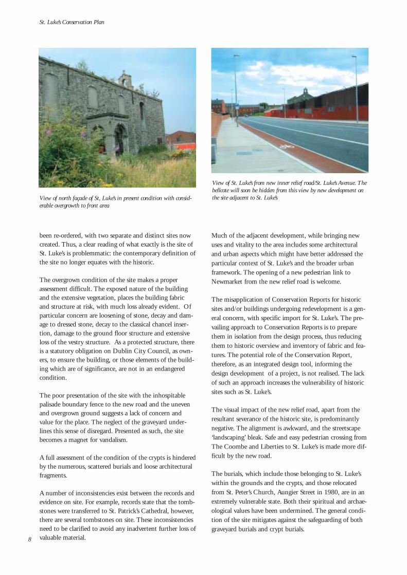
been re-ordered, with two separate and distinct sites nowcreated. Thus, a clear reading of what exactly is the site ofSt. Luke’s is problemmatic: the contemporary definition ofthe site no longer equates with the historic.
The overgrown condition of the site makes a properassessment difficult. The exposed nature of the buildingand the extensive vegetation, places the building fabricand structure at risk, with much loss already evident. Ofparticular concern are loosening of stone, decay and dam-age to dressed stone, decay to the classical chancel inser-tion, damage to the ground floor structure and extensiveloss of the vestry structure. As a protected structure, thereis a statutory obligation on Dublin City Council, as own-ers, to ensure the building, or those elements of the build-ing which are of significance, are not in an endangeredcondition.
The poor presentation of the site with the inhospitablepalisade boundary fence to the new road and the unevenand overgrown ground suggests a lack of concern andvalue for the place. The neglect of the graveyard under-lines this sense of disregard. Presented as such, the sitebecomes a magnet for vandalism.
A full assessment of the condition of the crypts is hinderedby the numerous, scattered burials and loose architecturalfragments.
A number of inconsistencies exist between the records andevidence on site. For example, records state that the tomb-stones were transferred to St. Patrick’s Cathedral, however,there are several tombstones on site. These inconsistenciesneed to be clarified to avoid any inadvertent further loss ofvaluable material.
Much of the adjacent development, while bringing newuses and vitality to the area includes some architecturaland urban aspects which might have better addressed theparticular context of St. Luke’s and the broader urbanframework. The opening of a new pedestrian link toNewmarket from the new relief road is welcome.
The misapplication of Conservation Reports for historicsites and/or buildings undergoing redevelopment is a gen-eral concern, with specific import for St. Luke’s. The pre-vailing approach to Conservation Reports is to preparethem in isolation from the design process, thus reducingthem to historic overview and inventory of fabric and fea-tures. The potential role of the Conservation Report,therefore, as an integrated design tool, informing thedesign development of a project, is not realised. The lackof such an approach increases the vulnerability of historicsites such as St. Luke’s.
The visual impact of the new relief road, apart from theresultant severance of the historic site, is predominantlynegative. The alignment is awkward, and the streetscape‘landscaping’ bleak. Safe and easy pedestrian crossing fromThe Coombe and Liberties to St. Luke’s is made more dif-ficult by the new road.
The burials, which include those belonging to St. Luke’swithin the grounds and the crypts, and those relocatedfrom St. Peter’s Church, Aungier Street in 1980, are in anextremely vulnerable state. Both their spiritual and archae-ological values have been undermined. The general condi-tion of the site mitigates against the safeguarding of bothgraveyard burials and crypt burials.
St. Luke’s Conservation Plan
8
View of St. Luke’s from new inner relief road/St. Luke’s Avenue. Thebellcote will soon be hidden from this view by new development onthe site adjacent to St. Luke’sView of north façade of St, Luke’s in present condition with consid-
erable overgrowth to front area

Policies BeartaisTo ensure the retention of the significance of St. Luke’sand, to assist in managing the site, planning appropriaterepairs, restoration, redevelopment and adaptation works,the policies of the Conservation Plan have been developedin consideration of the current legislative framework andthe various statutory and guidance policies and plans.Underpinning the policies are a series of key objectives:
• To establish criteria and guidance for the appropriateand sustainable re-use of St. Luke’s, including shortand long term uses
• The improved access to and presentation of St. Luke’s,the building and the site
• The protection and enhancement of the building andsite in a manner which retains their significance andcomplies with statutory obligations associated with itsprotected status
• To improve connections between St. Luke’s and otherparts of the local area and the wider City Centre area
• To protect the sacred aspects of St. Luke’s as a burialground
• To protect and enhance the particular sense of placewhich pertains to St. Luke’s
The policies, therefore, propose:
Executive Summary
9
Policy 1That a Steering Group be established, which includesrepresentatives of the key stakeholders, to oversee theimplementation of the Conservation Plan policiesand recommendations.
Policy 2The future use and ownership of St. Luke’s should beguided by Dublin City Council and should reflectthe public spirited intentions of the RepresentativeChurch Body when it transferred ownership of St.Luke’s in 1990 to, as it was then, DublinCorporation.
Policy 3That the future use of St. Luke’s should, in a mannerwhich will retain the significance of the place, facili-tate public access to the building and site, add to thesocial and cultural infrastructure of the area, into thefuture and be socially, culturally and economicallysustainable.
Policy 4It is desirable that any new use should allow publicaccess through the site, thus facilitating the connectionbetween The Coombe and the Cathedrals’ Precinct, toNewmarket and its urban hinterland.
View of St. Luke’s from apartment complex off New Row. This viewis now altered following development of site to the west of St. Luke’s
Interior view, while still in use, facing westwards towards thegallery. Reproduction courtesy of the Representative Church BodyLibrary
Policy 5Due to the extent of burials within the grounds of St.Luke’s it is preferable that any new use be accommo-dated within the footprint of the existing building.Any decision to allow disturbance of in situ burials, as

St. Luke’s Conservation Plan
10
Policy 6That the future use of St. Luke’s will acknowledgethrough function and/or physical design, the rich his-tory of the place and its relationship with theLiberties/Coombe area.
Policy 9Any new landscaping scheme for the site shouldacknowledge the historic character and functions ofthe site and, equally, seek ways in which to improvethe presentation of St. Luke’s, in particular its north-ern aspect onto the new road.
Policy 10That the surviving historic boundary walls to thesouth of the site and the Newmarket Gate areretained and restored. That the surviving historicboundary walls to the east of the site are substantiallyretained and, where partial removal is carried out, itis done in the context of facilitating access to the siteand improving connections with the adjacent area.That the Newmarket gateway be retained as anentrance to the site.
Policy 8That the sacred nature of the site as a burial groundis respected in any future use of St. Luke’s, in particu-lar the grounds.
Policy 11That the swifts, observed as welcome visitors to thesite, continue to be accommodated.
Policy 7That the surviving grounds at St. Luke’s are protectedas a green space within the area, that they are notused as a car park and, that they are made accessibleto the public.
part of necessary excavation of ground to facilitate anew use, should be assessed against achieving theobjectives for better access to the site and/or theextent to which the new use would fulfil the policiesand recommendations of the Conservation Plan.
Limestone (Dublin calp)window surround with somesurviving iron glazing bars ina corroded condition.Windows have been blockedup crudely for security.
Front (northern) area, date unknown, but likely to be prior to church closure. Reproduction courtesy of theRepresentative Church Body Library

Executive Summary
11
l: The Victorian porch, erected against the original granite door ofthe north façade, lacks the finesse of the earlier surround which,carved by John Whinrey, was one of the more notable architecturalfeatures of the early 18th century buildingr: The bell and bellcote before the bell was moved to St. Patrick’sCathedral. The bellcote on the west gable is a notable landmark inthe area. The bell, which was cast in 1903 from the two originalbells of 1714, is now displayed in St. Patrick’s Cathedral
Pages, showing final accounts figured up, from the original buildingrecord of the church, which survive in a complete state
Reproduction of above images courtesy of the Representative ChurchBody Library
Policy 15The bellcote on the west gable is a distinctive featureof St. Luke’s and should be retained. Considerationshould be given to reinstating the 1906 bell, if theChurch of Ireland were willing to return it.Alternatively , a new bell could be commissioned andinstalled.
Policy 16The retention of the Victorian porch erected againstthe original door on the north façade should bereviewed against established conservation principlesof retaining historic layers, and the architectural/aes-thetic benefits of repairing and restoring this impor-tant original granite doorway, by John Whinrey. Anydecision to remove the Victorian porch should beweighed against the extent of surviving historic fabricfrom the granite door surround and consequent levelof restoration required to reinstate this feature.Further, the possible future requirements for a pro-tected entry/porch as part of a new use, should befully assessed before any consideration to remove theexisting porch is taken.
Policy 14To avoid disturbance of burials, any new building toreplace the vestry structure (which only partially sur-vives) should preferably fit within the footprint of theformer structures (ref Policy 5).
Policy 12In accordance with the statutory obligations pertain-ing to the protected structure status of St. Luke’s, thatthe surviving structure of the Church should beretained and restored, including the external walls,window and door opes, the ground floor nave, theeast chancel and the crypts.
Policy 13The integrity of the historic single volume should beconsidered in any adaptation and its relationship withthe classical east chancel set-piece. Any structuralinstallations to support new interventions should beconsidered against the resultant negative impact onthe crypts, which should be minimised.
Policy 17The complete and very rare surviving original build-ing records for St. Luke’s should be published.

St. Luke’s Conservation Plan
12
Policy 18An inventory-based review of material, includingarchitectural elements, graveslabs, etc., belonging toSt. Luke’s should be carried out to establish theextent of surviving material and its location and con-dition. Where the findings of this study conflict withexisting records, the records should be appropriatelyamended.
Policy 19A building and site maintenance programme shouldbe put in place to ensure the proper conservation ofthe site. This should include regular monitoring andinspection and should form part of any lease or own-ership agreements.
Policy 23The physical presentation of the public realm of St.Luke’s Avenue, including tree planting, public light-ing, ground surface treatments, signage, etc., shouldbe improved and upgraded with due regard to theimmediate setting around St. Luke’s.
Policy 24In choosing names for new developments in the area,consideration should be given to relevant historicaland cultural associations in accordance with the poli-cies on street and place naming included in the DraftDublin City Development Plan, 2005 – 2011.
Policy 20New development taking place adjacent or proximateto St. Luke’s should consider any historic connectionsbetween sites. Opportunities to improve existing, orfacilitate new, links should be explored as should thefacilitation of access, vehicular (construction, mainte-nance and service only) and pedestrian, to the site.
Policy 21The impact of new development in the area of St.Luke’s should be reviewed with regard to its implica-tions for the significance of St. Luke’s.
Policy 22Consideration should be given to how uses associatedwith new developments in the area consolidate andsupport the role and character of St. Luke’s.
The arched gateway onto Newmarket, as it standstoday
The chancel pre-1975. Reproduction courtesy of the Representative Church BodyLibrary

Recommendations MoltaíA series of recommendations for specific programmedactions are included in the Conservation Plan which willsupport the policies. Key amongst these are:
Recommendations A, D and I: Early use of St. Luke’s fora programme of events/activities which would, in additionto bringing the place back into use, raise general publicawareness and appreciation of, and stimulate interest in,St. Luke’s. These would be planned in conjunction withcarrying out a programme of works, under supervision, tosafeguard the building and grounds, facilitate access toand, generally, improve the presentation of building andsite.
Recommendation B: In order to generate further interestand ideas for the future of St. Luke’s it is recommendedthat an Ideas Competition is held at an early stage.
Recommendation C: Any proposals for long-term useshould be supported by an appropriate feasibility studyand business plan.
Recommendation E: A Graveyard Maintenance/Management Scheme should be put in place in conjunc-tion with the controlled grounds improvement/restorationworks. This Scheme, which should follow the guidelinesissued by the DoEHLG and should include local history,could record the surviving graveslabs and, following con-firmation of their origin, advise on the most appropriatelocation for those graveslabs which have been moved fromtheir original location. The Scheme should also addressbiodiversity aspects of the site, in line with the DublinCity Heritage Plan, and include management schemes forflora and fauna.
Recommendation H: As part of compliance with statuto-ry obligations, an early programme of protection andrepair works should be carried out to conserve the fabricof the building (these are listed in outline in Section 12.5of the Conservation Plan).
Recommendation J: Surviving architectural fragmentswithin the crypt space should be retrieved, recorded and,should either form part of a display of surviving loose archi-tectural fabric, which could be housed in an area in thecrypt and be available for research or general display, or,alternatively be curated by an appropriate existing museum.
Recommendation K: Access to St. Luke’s for vehicle andpedestrians should be provided via the adjacent easternsite, currently owned by Dublin City Council, as part ofany redevelopment of this site. Consideration might begiven to transfering a section of this vacant site to St.Luke’s to facilitate this access and allow any redevelopmentworks to proceed independent of the vacant site‘s develop-ment programme.
Executive Summary
13
Policy 25The disturbed human remains within the crypts are tobe exhumed and cremated in accordance with the con-ditions of the Covenant of Indenture. Prior to thisthere is to be a bone count of remains to determineminimum numbers and a record of any pathologypresent.
View of one of the barrel-vault-ed passageways leading to theburial chambers in the cryptwith loose architectural frag-ments stood against the wall
The graveyard to the south ofthe church pictured before the1986 fire. Reproduction cour-tesy of the RepresentativeChurch Body Library
Irish School, St. Luke’s, the Coombe, c. 1818. Reproduction of thiswork is by courtesy of the National Gallery of Ireland

Recommendations L and M: Consideration should begiven to densely planting the upper-level courtyards andbalconies of the development immediately west of St.Luke’s. The Widows Alms House development should ref-erence the historic connection with St. Luke’s.
Recommendation O: The exhumation and cremation ofthe human remains in the crypts should be put in hand inthe short term.
In order to ensure the early and proper implementation ofthe key policies and recommendations of the ConservationPlan, it is suggested that a programme of immediate/short-term actions be put in hand in 2004. These would include:
• Works to secure, protect and order the building andsite, including essential repair works to the buildingfabric in order to fulfil the protected structure status ofSt. Luke’s
• Works to facilitate access to and through the sitewhich will allow the opportunity to use the buildingand site
• Works to improve the presentation of the buildingsand site and thus, increase awareness of St. Luke’s
• Temporary and/or short term use of St. Luke’s includ-ing a programme of events/projects aimed at raisingappreciation of and awareness and interest in the site
• Attending to the human remains within the crypts,following the method agreed by all statutory parties.
• The Ideas Competition for the future use of St. Luke’s
• The Graveyard Management Scheme
In order to achieve the above programme, initial invest-ment will be required. It is hoped that this investment canpump-prime a suitable and sustainable long term new usefor St. Luke’s. If such a use is not so readily forthcoming,then it may be necessary to allow short to medium-termuses in the interim. A Steering Group which includes rep-resentatives of all key stakeholders, should be put in placeto oversee implementation of the Conservation Plan. TheConservation Plan should be reviewed and up-dated, asnecessary, on an annual basis. It is important, that toachieve a successful implementation of the Plan, there is aswide acceptance and active support of the ConservationPlan as possible.
St. Luke’s Conservation Plan
14
Surviving shell of vestry with tombstones resting against boundarywall
View of St. Luke’s from Newmarket, 2003

“Listening to the tradition that does not give itself up to thepast but thinks of the present”1
1.0 Introduction
1.1 BackgroundThis Conservation Plan for St. Luke’s2 Church was com-missioned by Dublin City Council, in conjunction with theHeritage Council, in May 2003. The context for commis-sioning the Conservation Plan arises from “Dublin CityCouncil’s desire to establish an agreed and appropriate reuse forthe Church, while retaining its significance.“ (extract fromConservation Plan brief, dated 18 February 2003, andincluded in Volume 2, Appendix A).
St. Luke’s Church, which was built between 1715 and1716, is situated between The Coombe and Newmarket.The original site, which spanned between the former streetto the north and latter urban space to the south, has beenbisected by the new Coombe Relief Road, recently namedSt. Luke’s Avenue. The effect of this has been to make 2sites, one, to the south, which contains the former churchand its graveyard, the second, northern, site contains theformer Widows Alms House and the former main entranceto the church from The Coombe. This latter site is nowbeing developed privately as a mixed use development. Theformer site is that owned by Dublin City Council and towhich the main recommendations in this Plan areaddressed.
St. Luke’s was the formerParish Church of the St.Nicholas Without andSt. Luke’s Parish. Thiswas subsumed within theSelect Vestry St. Patrick’sCathedral Group ofParishes and, since theclosure of the church forpublic worship in 1975,the parish worships in St.Catherine and St. JamesChurch, DonoreAvenue. The church wasbadly damaged by fire in1986 and, unused andunmaintained since, isnow in a ruinous condi-tion. The grounds areovergrown and inaccessible to the public, although there isevidence of regular trespass and vandalism.
St. Luke’s is a protected structure and also a recorded mon-ument within the Dublin zone of archaeological potential(DU018 020).
St. Luke’s is now at a pivotal stage in its history: it has beenunoccupied and unused for the last 17 years; its physicalcondition requires early attention to ensure its survival andcompliance with statutory obligations associated with its
15
Part One: Process
Fig. 1.1 Aerial view of St. Luke’sbefore the new relief road wasconstructed.
1. Martin Heidegger, quote taken from Introduction essay by Hannah Arendt to Walter Benjamin, Illuminations, Essays andReflections: Schoken Books New York (1968)
2. St. Luke’s Church is the name of the church. It is the parish church of St. Nicholas Without and St. Luke’s. Throughout theConservation Plan we have referred to the building, the site and the place as either St. Luke’s or St. Luke’s Church, except where theparish is being referred to specifically. It is worth noting also that the Covenant of Indenture (ref. Appendix B) restricts the use of orreference to any ecclesiastical name or the use of the term ‘church’ in any future use of St. Luke’s.

protected structure status; it is located in an area which isundergoing significant social and physical change; it cur-rently presents itself in a new aspect. There is a shared opin-ion that St. Luke’s can play an important role in the currentand future renewal of this historically, socially and cultural-ly rich part of Dublin City.
1.2 Scope of Conservation Plan
“The Conservation Plan is a process that seeks to guide thefuture development of a place through an understanding of itssignificance”. 3
In accordance with the principles laid down in the ICO-MOS Burra Charter, and subsequent guidance documents,including James Semple Kerr’s Guide to Conservation Plans(ibid.) and the UK Heritage Lottery Fund’s ConservationPlans for Historic Places (1996), this Conservation Planaims to provide the following:
• An understanding of an historic place and what is sig-nificant about it
• Identification of issues which threaten to undermine orde-value this significance
• Appropriate policies and recommendations to assist in:managing the site; planning repairs or restoration; plan-ning new developments and, managing a programme ofregular maintenance.
In preparing a Conservation Plan a holistic and, often mul-tidisciplinary examination of the site is required, to ensurethat a full and broad understanding and assessment informsthe policies and recommendations. As part of the Planprocess, the various aspects of significance are described, inaddition to any conflicts which may exist between these.Most important also is the identification of where gaps existin the current understanding of the site, to ensure inadver-tent damage does not occur as a result of this.
Finally, the Conservation Plan should enable the conse-quences of any specific proposal to be assessed to establishwhether they will retain, or indeed enhance, the signifi-cance of the site.
1.3 Methodology and Layout
The process and general sequencing of the Plan can besummarised as follows:
• Gathering Information - Survey of the builing, the site, /Understanding the Site the urban context; ecological
survey, landscape survey.- Architectural Historical
research; urban history andcontemporary context research; legislation and statuto-ry policy review;
St. Luke’s Conservation Plan
163. James Semple Kerr, (1996) The Conservation Plan: a guide to the preparation of Conservation Plans for places of European cultural
significance, 4th ed., The National Trust of Australia (NSW), Sydney.
Fig. 1.2 Front, northern façade of St. Luke’s with its prominentnew aspect to the relief road.
Fig. 1.3 The siteboundary (out-lined in red) asset out in thebrief. The origi-nal entanceavenue to St.Luke’s is shownin purple.

• Consultation - Regular Steering Group meetings
- Stakeholder Workshop- Public Meeting- Meetings with key Informants
and Stakeholders- Review of Written
Submissions (This is describedin more detail on page 13).
• Analysis and Assessment - Identify significance- Prepare statement of signifi-
cance- Identify threats to significance- Identify gaps in understand-
ing and any conflicts betweendifferent significances
• Prepare Policies and - Identify categories for Recommendations policies/recommendations
- Identify policies to guideongoing issues
- Identify programmable recommendations for specificactions
The above suggests a sequence of actions carried out oneafter the other. However, many ran concurrently and,indeed, some policies and recommendations were devel-oped at an early stage in the process.
The layout of the plan, generally follows the above format.The Plan is divided into four parts:
• Part One introduces the background and context to thePlan. It also contains a summary report on the consul-tation process (further elaborated on in Appendix C)
• Part Two, contains 3 descriptive essays which cover dif-ferent aspects and issues relating to St. Luke’s, includingits socio-cultural context in the area, an architecturalappraisal and a discussion on the contemporary con-text. It also includes an assessment of condition (build-ing and site), environment issues and archaeologicalissues. Part Two identifies many of the challenges whichface St. Luke’s today and justify this Conservation Plan.
• Part Three sets out both what is significant about St.Luke’s and what issues put this significance under threat
• Part Four contains the policies and recommendationsdeveloped for St. Luke’s and a brief comment on imple-mentation and review.
A separate volume of Appendices contains supplementaryinformation, reports and submissions gathered as part ofthe Conservation Plan process. (This is a separate collectionof documents available through the Dublin City CouncilHeritage Officer and the Dublin City Archives which islocated at 138/144 Pearse Street).
1.4 Acknowledgements
The consultants would like to acknowledge the assistanceof several individuals and organisations in the preparationof this Plan:
Proceess
17
Fig. 1.4 Front,northern façadeof St. Luke’swith its promi-nent new aspectto the reliefroad.

• St. Luke’s Conservation Plan Steering Group4
• Dublin City Council• Individuals and organisations who contributed to the
various consultation processes, in particular those whomade written submissions and attended the Workshopand Public Meeting. Appendix C contains a list of allthese, including copies of written submissions.
• The St. Nicholas of Myra Parish Centre for generouslyproviding space and refreshments for the Workhsopand Public Meeting
• Cllr. John Gallagher for his generous assistance inorganising the consultation processes
• Canon John Crawford, Vicar of the St. Patrick’s Groupof parishes
• The Representative Church Body• The South West Inner City Network (SWICN)• Department of Geography, Trinity College Dublin• Peter Walsh, Historian• David Kearney, Chief Executive, Dublin YMCA, for
providing documentation on the transfer of burialsfrom the former St. Peter’s Church, Aungier Street toSt. Luke’s
• Ruth Elliott, Archaeological Development ServicesLtd., who facilitated access for the consultants to theexcavation and Archaeological reports relating the St.Peter’s Church
• Dr. Laureen Buckley M.Sc., Consultant Osteoarchaeologist
• Linda Shine, National Museum of Ireland• Seán Kirwan, DoEHLG• National Gallery of Ireland for reproduction of 1818
painting of St. Luke’s Church• Kathleen Biddick, PhD, Fulbright Fellow
1.5 Consultant Team
The Consultant Team who prepared the ConservationPlan is as follows:
Shaffrey Associates Architects: Gráinne ShaffreyEamonn KehoeCaitríona HarveyMartina Milarch
John Montague M.A, Architectural HistorianClaire Walsh, Archaeological Projects Ltd.Daphne Levinge-Shackleton, Historic LandscapeConsultantRoger Goodwillie, Ecologist
St. Luke’s Conservation Plan
18
4. The Steering Group comprises: Donncha O’Dulaing, Heritage Officer, Dublin City Council (DCC), Mary Conway, Senior Planner,DCC; Nicki Matthews, Conservation Officer, DCC; John Flynn, Senior Executive Architect, DCC, Seán Purcell, Project Manager,Liberties Coombe IAP (DCC); Ruth Johnson, City Archaeologist, DCC; Kieran Rose, Senior Planner, DCC and, Mary Hanna,Architectural Officer, The Heritage Council. Secretary to the Steering Group was Bríd Kelliher, Staff Officer, DCC.

2.0 Consultation
The consultation process for the Conservation Plan con-sisted of four main elements:
1. Workshop with stakeholders andkey informants:
An invited workshop session was held in the St Nicholas ofMyra Parish Centre on 23 July 2003. The invitees includedlocal elected representatives, local community group, indus-try and trader’s representatives, members of conservationand heritage bodies, adjacent property owners and develop-ers, members of a research team from Trinity CollegeDublin and University College Dublin and, individuals andorganisations who had expressed interest to Dublin CityCouncil in St. Luke’s. A full list of those invited and thosewho attended is in included in Appendix C, in addition toa minute of the workshop proceedings.
The context for the Conservation Plan was introduced fol-lowed by short presentations on the historical, socio-eco-nomic and tourism aspects of St. Luke’s and The Coombearea in general. The issues arising from these presentationsand the ensuing discussion included:
• the importance of St. Luke’s as an historic survival in anarea which had experienced much loss of historic fabric
• Concerns over access to affordable housing and thechanging social profile in the area
• The significance of Newmarket and its potential• The findings of a recent tourism survey in the area which
indicated that the main tourism asset is the communityand the need to develop a sustainable tourism strategywhich combines local involvement, environmental con-cerns and tourist needs.
• The potential role for St. Luke’s as part of the tourismstrategy for the area
Following this there was a discussion on the potential futureuse of St. Luke’s. A number of criteria for assessing any pro-posals as follows:
Integration with (local) community(ies) – what will thenew use add? The uses discussed ranged from re-use forChristian worship, (a number of Christian churches attend-ed the workshop, having previously expressed interest in there-use of St. Luke’s for their services) to its use as a her-itage/cultural centre.
Issues of public access, integration of use within the com-munity and long-term sustainability were raised in connec-tion with the suggested uses. The implementation of anearly programme of works to improve the presentation andsecurity of the building and site was suggested.
The workshop concluded by re-stating the purpose andscope of the Conservation Plan as a document to define theimportance of the building and site, to identify what threat-ens this and to set down policies for protecting the impor-tance.
Proceess
19
Fig. 1.5 St. Luke’s as seen fron the residential development to thesouth of the site.

2. Public Meeting
On the evening of the 24th July 2003 a public meeting washeld in the St. Nicholas of Myra Parish Centre. 15 peopleattended, including individual residents from the area andrepresentatives of local community/interest groups. A fulllist of attendees and a more detailed minute of the pro-ceedings is included in Appendix C.
The meeting discussed three questions:
a What does St. Luke’s mean to you? (i.e., in what way isit important)?
b What guiding principles should the Conservation Planinclude in terms of the future use and adaptation of St.Luke’s?
c What uses might be appropriate for St. Luke’s?
While a range of stories and memories relating to St. Luke’swere told, only two of the attendees had been in the churchand one only after the church was de-consecrated, for Irishlessons. Despite this, a strongly held sense of value wasexpressed by all attendees for St. Luke’s and interest in itsfuture use. Amongst the main issues arising from the meet-ing are the following:
• Future use(s) should engender a “shared sense of owner-ship”
• Adaptation and new use should make most of opportu-nities for local employment
• Restoration of St. Luke’s offers opportunity to developtraditional building skills
• Graveyard should be treated with respect and recordingof gravestones should be carried out
• The site is valuable as open space in an area where theproportion of publicly accessible open space is low com-pared to other parts of the City
• The potential of Newmarket as a lively urban spaceshould be realised and the restoration of St. Luke’sshould aim to improve its integration into the broaderCoombe area. to the area?
• Physical integration – how will the new use integratewith the surrounding area?
• What impact will the new use have on the existing build-ing and the site?
• Is the new use sustainable in economic terms and in rela-tion to future needs/demands?
• The future use of St. Luke’s offers an opportunity toproperly record and present the history of theLiberties/Coombe area, a history which has not yet beenfully recorded or appreciated.
• The principle that investment in good public projects and
the public realm brings indirect economic return needs tobe appreciated when considering uses for St. Luke’s.
• The meeting requested that the Conservation Plan record thatwhatever use is eventually agreed for St. Luke’s it should be onethat will be of significance to the local area and community. Adecision on the future use of St. Luke’s should not be taken solelyon commercial grounds, which the attendees considered was thesituation with the majority of recent developments in the area.
In terms of possible future uses for St. Luke’s the followingwere suggested:
• Urban Folklore Museum, charting history of the labour-ing classes, up to and including contemporary accounts.It was suggested that the trade union organisations maypart fund such a use
• ‘Cultivate Centre’ or, green technology centre• Location for civil wedding ceremonies• Performance Space
3. Consultations with key informants:
Structured meetings with a number of stakeholders andinterested groups expanded the consultation process. Theseincluded meetings with :
• Rev. Canon John Crawford, Vicar of the St. Patrick’sCathedral Group of Parishes, of which St. Luke’s is nowpart;
• Cllr. John Gallagher, Labour City Councillor for the areaand a valuable source of local history and information;
• Dr. Andrew McLaren, Dr. Michael Punch, Sineád Kellyand Dr. Declan Redmond, members of the TrinityCollege Dublin and University College Dublin researchteam, who, with SWICN (South West Inner CityNetwork), are carrying out research into recent develop-ment patterns and outcomes in the Liberties/Coombearea
• Martin Kavanagh of Dublin City Council DevelopmentDepartment.
St. Luke’s Conservation Plan
20

4. Written Submissions
As part of the consultation process written submissionswere invited and those received are included in Volume 2,Appendix C of the Conservation Plan.
In addition to the above there was regular consultationmeetings between the consultant team and the SteeringGroup. These meetings provided a constructive forum asthe Plan developed.
In summary, the consultation process illustrated aninformed understanding of the issues and complexities asso-ciated with the proper conservation of St. Luke’s and, inparticular, “finding an agreed and appropriate future usewhile retaining it’s significance”5. It has also highlighted ashared deep concern for the future of St. Luke’s. However,while the process of consultation underlines the sharedobjectives to protect the significance and realise the poten-tial of St. Luke’s, the sometimes differing solutions put for-ward to achieve this, illustrated the complexities of conser-vation and the difficulty in achieving consensus.
215 . Extract from Dublin City Council Brief for St. Luke’s Conservation Plan, dated 13 February 2003, included in Volume 2,
Appendix A)
Proceess

… there is a growing awareness of the simultaneity and inter-woven complexity of the social, the historical and the spatial,their inseparability ... 1
3.0 St Luke’s Church Chronology
1707 By an Act of Parliament (6 Anne, 21), theParish of St Luke the Evangelist was formallyestablished, dividing it from its parent parish ofSt Nicholas Without. The new parish waslocated south of the Coombe between twochannels of the Poddle River running downCrooked Staff on the west and up theBlackpitts on the east. The parish would comeinto effect upon the death or retirement of theincumbent minister, in this case the dean of StPatrick’s Cathedral, John Stearne. A number ofother parishes were formed by the same Act,also by way of a division of former largerparishes.
1713 On 1st May 1713, Dean Stearne was appointedBishop of Clogher, and as a result the Parish ofSt Luke the Evangelist formally came intobeing. The first baptisms of children belongingto the new parish took place in May 1713 andwere later recorded in the combined Baptismaland Marriage Register of St Luke’s. The firstminister of the parish was Anthony Dopping,son of the more famous Anthony Dopping,Bishop of Meath, although the son would laterbecome the Bishop of Ossory 1741-43.
1714 The first Cess (corruption of the word assess-ment, and in this case an ecclesiastical tax ortithe) on the parish came to £100 18s
1715 Work on the construction of the church beganin February, the first payment was made on the19th of February, 1715, “towards subsisting thelabourers that diggs & carrys away the earth ofthe valts”. The building of the church tookplace under the overall supervision of SirThomas Burgh the Surveyor General, andinvolved a group of craftsmen, John Whinreythe stonecutter, Isaac Wills the master carpenterand Francis Quin and William Caldbeck thebricklayer and mason respectively, who wereprominent building practitioners in Dublin atthe time.
1716 The church was completed towards the end ofthe year so that it was in a position to be conse-crated by Archbishop Edward Synge at a serviceon October the 8th. The total cost of the con-struction of the church was £2046-15s-6d.
1745-70 Theophilus Brocas (of Huguenot extraction)was minister at St Luke’s and an importantinstigator in the development of the silk indus-try in the area. He was presented with theFreedom of the Weavers’ Guild and later elect-ed a director of the Irish Silk Warehouse in1762.
1789 The parishioners of St Nicholas Without wereforced to briefly re-join with their offspringparish of St Luke’s in their church on theCoombe because of damage caused by flooding
St. Luke’s Conservation Plan
22
Part Two: Understanding the Place
1. Edward W. Soja, Thirdspace: expanding the scope of geographical imagination, in Architecturally Speaking: Practices of Art, Architectureand the Everyday, Ed. Alan Read, Routledge, London (2000)

to the north transept of St Patrick’s Cathedralwhere the former parish worshipped. To thisend they contributed £90 towards the buildingof new galleries in St Luke’s. However thisarrangement, despite the construction of thenew galleries, was a short-lived one, and the StNicholas Without community returned to StPatrick’s where for a while they shared the LadyChapel with the Huguenot community.
c. 1818 Watercolour painting in the National Galleryof Ireland of the north exterior of St Luke’schurch.
1837 A new organ was installed, probably the organwhich had survived when the church wascleared in 1975.
1862 Due to renewed difficulties with the badlymaintained north transept in St Patrick’s cathe-dral, the parish of St Nicholas Without was re-united for good with its old offshoot the parishof St Luke’s. Some alterations were made to theinterior of the church to facilitate the extracongregation.
1883-84 Further alterations were made on the church,including the removal of the north and southgalleries, the replacement of the box pews, andthe replacement of the old triple-decker pulpitby a separate pulpit and reading desk on eitherside of the sanctuary.
1899- Major refurbishment works took place necessi-tating the removal of the congregation duringthe construction work to the nearby parishschool in New Street. Works included the con-struction of a new classically articulated chancelwith a barrel vault, and a new semi-circularwindow depicting Christ calming the storm; anew stone altar; and the replacement of theprevious compass ceiling by a flat compartmen-talised one.
1903 A new bell was cast using the metal from theprevious two which had been created by HenryFord in 1714. This bell, paid for by a JohnNewman, was inscribed To the Glory of Godand in Memory of the Coming of the Huguenots1685. It is currently stored in St Patrick’sCathedral.
1957 The 1957 Planning Scheme is drawn up by thethen Dublin Corporation setting up the lowdensity urban form of the city.
1971 & An Foras Forbatha’s Dublin Transportation 1972 Study (DTS) lays down recommendations for
new roads and road widening schemes.
1975 After St Luke’s Parish became part of the StPatrick’s Cathedral Group of Parishes, thechurch itself was closed down. The final servicewas held on the occasion of the HarvestThanksgiving on the 19th of September.
1981 The church was leased to a publishing compa-ny, but suffered under continuous vandalism.
1986 On the 28th of October the interior and theroof of the church were destroyed by a mali-cious fire.
1986 The first Urban Renewal Schemes under theFinance Act.
1990 The Representative Church Body sold thechurch, subject to a covenant outlining condi-tions for future use, for a peppercorn fee of £5to the then Dublin Corporation.
1994 The Cork Street/Coombe Relief Road is adopt-ed by Dublin City Council as a dual carriage-way.
1998 The Liberties/Coombe Integrated Area Plan ispublished.
1998 The EIS for the Cork Street/Coombe ReliefRoad is prepared.
1999 The 1999 Planning and Development Act putsthe protection of the built heritage on a statu-tory footing.
2001 Construction of relief road starts.2002 Relief Road opens.2003 Construction starts on Widows’ Alms House
site.2005 Launch of St. Luke’s Conservation Plan.
Understanding the Place
23
1902
4.0 St. Luke’s in the Coombe
4.1 St. Luke’s Parish – Location
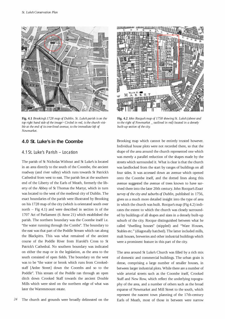
The parish of St Nicholas Without and St Luke’s is locatedin an area directly to the south of the Coombe, the ancientroadway (and river valley) which runs towards St Patrick’sCathedral from west to east. The parish lies at the southernend of the Liberty of the Earls of Meath, formerly the lib-erty of the Abbey of St Thomas the Martyr, which in turnwas located to the west of the medieval city of Dublin. Theexact boundaries of the parish were illustrated by Brookingon his 1728 map of the city (which is orientated south overnorth – Fig 4.1) and were described in section ix of the1707 Act of Parliament (6 Anne 21) which established theparish. The northern boundary was the Coombe itself i.e.“the water running through the Combs”. The boundary tothe east was that part of the Poddle Stream which ran alongthe Blackpitts. This was what remained of the ancientcourse of the Poddle River from Harold’s Cross to StPatrick’s Cathedral. No southern boundary was indicatedon either the map or in the legislation, as the area to thesouth consisted of open fields. The boundary on the westwas to be “the water or brook which runs from Crooked-staff [Ardee Street] down the Coombs and so to thePoddle”. This stream of the Poddle ran through an openditch down Crooked Staff towards the ancient DoubleMills which were sited on the northern edge of what waslater the Warrenmount estate.
The church and grounds were broadly delineated on the
Brooking map which cannot be entirely trusted however.Individual house plots were not recorded there, so that theshape of the area around the church represented one whichwas merely a parallel reduction of the shapes made by thestreets which surrounded it. What is clear is that the churchwas landlocked from the start by ranges of buildings on allfour sides. It was accessed down an avenue which openedonto the Coombe itself, and the dotted lines along thisavenue suggested the avenue of trees known to have sur-vived there into the later 20th century. John Rocque’s Exactsurvey of the city and suburbs of Dublin, published in 1756,gives us a much more detailed insight into the type of areain which the church was built. Rocque’s map (Fig 4.2) indi-cates the extent to which the church was closely surround-ed by buildings of all shapes and sizes in a densely built-upsuburb of the city. Rocque distinguished between what hecalled “dwelling houses” (stippled) and “Ware Houses,Stables etc.” (diagonally hatched). The latter included mills,malt houses, breweries and other industrial buildings whichwere a prominent feature in this part of the city.
The area around St Luke’s Church was filled by a rich mixof domestic and commercial buildings. The urban grain isdense, comprising a large number of smaller houses, inbetween larger industrial plots. While there are a number ofwide arterial streets such as the Coombe itself, CrookedStaff and New Row, which reflect the underlying topogra-phy of the area, and a number of others such as the broadexpanse of Newmarket and Mill Street to the south, whichrepresent the nascent town planning of the 17th-centuryEarls of Meath, most of those in between were narrow
St. Luke’s Conservation Plan
24
Fig. 4.1 Brooking’s 1728 map of Dublin. St. Luke’s parish is on thetop right hand side of the image> Circled in red, is the church visi-ble at the end of its tree-lined avenue, to the immediate left ofNewmarket.
Fig. 4.2 John Rocque’s map of 1758 showing St. Luke’s (above andto the right of Newmarket _ outlined in red) located in a denselybuilt-up section of the city.

laneways and alleys terminating in tight spaces and crowd-ed interior courtyards. The area to the south-west of themedieval city was largely developed in the later 17th centu-ry and 18th century. It provided a distinct contrast to themore regular, high status and residential areas, which weredeveloped to the east of the walled town, for example thoselaid out by Dawson to the south, including Dawson Streetand Molesworth Street and Sackville Mall to the north –part of the great areas laid out by Luke Gardiner.
A long double range of industrial buildings, running fromthe Coombe on the north to Newmarket on the south, bor-dered almost directly onto the eastern edge of the churchbuilding. The church was bordered on the south by moreindustrial buildings. One of these was an especially largecourtyard building attached to a dwelling house whichformed the north-eastern corner of Newmarket. An 18th-century house on this site, which was destroyed by fire inthe late 1980s, was replaced by a gated apartment complex(see Fig. 4.3) which adjoins the southern wall of St Luke’schurchyard. It is worth noting that St Luke’s was not direct-ly accessible from Newmarket in the mid-18th century.Direct access from the market was not introduced untiltowards the end of the 19th century. The associated archedgateway has survived (Fig. 4.4), although it has been com-promised considerably by its isolated position. In 1756access to the church from this side was provided via alaneway from Skinner’s Alley to the west of the church,which itself connected Newmarket to the Coombe. Thechurchyard was bisected by the church, with a smaller areato the south, comprising a graveyard, while that to thenorth is illustrated by Rocque as a tree-lined garden.A compact square-planned structure on the north side of a
laneway from Skinner’s Alley represents the location of anAnabaptist meeting house (Fig. 4.6). There is a record inthe Church Building Accounts for “Walling the ChurchGround from the Meeting house & winterbotomsGround”. Directly to the north of the meeting house was awalled garden also separated from the churchyard. Whileworship by religious dissenters was tolerated during theperiod, Roman Catholic worship was not entirely outlawedas was sometimes suggested. The Penal Laws restrictingCatholic worship were inconsistent and certainly notabsolute. In 1756 there was a Catholic mass house, orchapel as Rocque refers to it, about a third of the way upAsh Street on the north side of the upper Coombe. This wasthe home of the Carmelite community (formerly ofWhitefriar Street) from 1728. Their S-shaped church build-ing was reasonably small in comparison to St Luke’s and wasthe nearest such church to it. However another largerchapel, wider (probably aisled) but a good deal shorter thanSt Luke’s, was located off Francis Street not very far fromthe current St Nicholas of Myra. According to a contempo-rary account, it served as the parish chapel for the RomanCatholics of St Nicholas Without, St Bride’s, St Kevin’s andSt Luke’s. Like St Luke’s Church it was landlocked in ahighly built-up area, but unlike its Protestant neighbour, itwas accessed (from Francis Street) via an arched entry and anarrow laneway.
Amongst other important institutions close to St Luke’sChurch was the Weaver’s Hall (marked WH on Rocque) onthe north side of the Coombe, almost directly opposite theentrance to the churchyard (see Fig. 4.7). This large-scalebrick building with granite quoins and a central nichewhich housed a statue of George II, was built in 1745. It
Understanding the Place
25
Fig. 4.3 Theview of St. Luke’sfrom the gatedapartment com-plex to the south.
Fig. 4.5 Thegraveyard area tothe south of thechurch picturedbefore the 1986fire.
Fig. 4.4 The arched gatewayonto Newmarket, as it standstoday.
Fig. 4.6 Section of Rocque’s mapshowing St. Luke’s, with theAnabapist meeting house, out-lined in red, to its immediatenorth-west. Also note theWeaver’s Hall in the top right-hand corner of the image.

was the headquarters of the Weavers’ Guild and it’s posi-tioning here reminds us of the central importance of thetextile industry in the area. Often associated with the com-ing of the Huguenots, the production of woollen goods wasestablished here before their arrival in any great numbers inthe closing decade of the 17th century. However theHuguenots brought with them new skills, especially in theproduction of silks and particularly poplin (a mixture of silkand wool), and a system of economic contacts at many ofthe more important European trading centres. The mar-riage and baptismal registers of St Luke’s church give us listsof the names and occupations of some of the residents in
the area. Recorded in the early years are a large number ofweavers, tanners, skinners, brewers, butchers alongside asmaller number of joyners, a shearmen, ropemakers,apothecaries, and many others simply listed as clothiers.Many of these belonged to a merchant class or were skilledcraftsmen owning their own homes.
The houses in which these artisans and labourers lived,combined workshop and dwelling house as one. Some hadshops on the ground floor to the street while many morehad workshops e.g. for weavers and other skilled craftsmenon upper floors in order to maximise available light. Theirgable-fronted houses, often two or three-storeys high, wereonce a common feature throughout the area of theCoombe, although almost none have survived.1 The essen-
tial form involved what is known as the cruciform roof. Thecorner fireplace was also a common element in these hous-es. The former involved a roof ridge set parallel to the streetfront, and placed in the centre of the house. A secondaryridge was placed, at the same height, perpendicular to thefirst ridge, so that a cross-shaped truss (in plan form) result-ed (see Fig. 4.8 – detail). The primary ridge was normallysupported, on one side of the house at least, by a chimney-stack shared between two houses across the party wall. Thechimney-stack, in turn, was set diagonally to the rest of thehouse, and so provided a corner fireplace in the front andback rooms against the party walls. A fine example of this
indigenous house type was the terrace of houses which oncestood along Chambers Street (see Fig. 4.8). A developmentof this form, which evolved towards the end of the 17thcentury and was popular for some thirty or so years into the18th century, was the Dutch Billy. Structurally very similarto the type already described, it was the articulation of thefaçade, by means of curving gables topped-off by triangularpediments, that was considered a Dutch influence. Thename Billy was a reference to King William III. A very fineterrace of Dutch Billys, with moulded string courses articu-lating the divisions between storeys, survived until the earlyyears of the 20th century in Sweeney’s Lane at the side ofMill Street (see Fig. 4.10).1
St. Luke’s Conservation Plan
26
Fig. 4.8 The ter-race of housesalong ChambersSt. with theirgable fronts andcruciform roofs.The detail belowillustrates therofile of the cruci-form roof.
Fig. 4.9 No. 10Mill Street as itstands today.
Fig. 4.7 TheWeaver’s Hall,demolished in 956.
1 No. 10 Mill Street (Fig. 4.9) is perhaps the sole survivor in the area of the gable-fronted house type. However the roof and gables wereremoved and replaced by a hipped roof in 1891 when the house was given a Gothic-Revival-type makeover when the house was incor-porated into the Methodist Mission established there in the middle of the 19th century.

4.2 History and topography of the Coombe
The area of the city to the south west of the medieval townhas always been one of mixed industrial and residential use.Its street patterns, as noted above, reflected as much the nat-ural topography of the area – its rivers and streams, the con-tours of high ground and low – as the patterns created bythe early private developers who put a more definite shapeupon the ground during the 17th and 18th century. Therestoration of the Stuart monarchy in 1660 brought a new-found stability to the capital, which continued (after theinterruption to the peace during the early 1690s), through-out the 18th century. This period of prosperity and relativepeace provided the opportunity for a succession of large-scale property developments in the city. A large proportionof the earlier changes, here in the Liberties, and to the eastof the medieval city, were the result of speculative develop-ments made by private individuals.
As we have seen, St Luke’s Parish was located on a strip ofland south of the Coombe. The boundaries of the area,which predate the formation of the parish, were defined bylandscape features and the ancient routes which theyformed. Perhaps the most important feature of the pre-urban landscape was the Slige Dála, the ancient route wayfrom Munster, which wended its way towards the early-Christian settlements south of the later city, along a rivervalley known as the Coombe. The sharp turns north andthen east along this valley, are still echoed by the character-istic turns in the road at the end of Cork Street, north intoArdee Street and then sharply east again onto the Coombe.This route formed the northern boundary of the area whichwas known later as Donore. The Slige Dála was joined near
the present Dean Street by the ancient route from thenorth, the Slige Midluachra, which finds its way there todayalong the present Francis Street. These two routes formed ajunction with the Slige Chualainn from south Leinster, at apoint just to the south of what was to become St Patrick’sCathedral (Fig 4.11).
Understanding the Place
27
Fig. 4.10 (left) DutchBillys on Sweeney’sLane.
Fig. 4.11 (right)Extract from H.B.Clarke’s MedievalMap of Dublin whichoverlays medievalDublin (c. 840 to c.1540) on the 1939OS Map of Dublin.It is taken from theRoyal Irish Academy’sIrish Historic TownsAtlas no. 11: Dublinby H. Clarke.
Fig. 4.12 Detail of the 1728 Brooking map showing the line of thePoddle running from the top right hand corner to the rear of NewRow towards St. Patrick’s at the centre (St. Luke’s is circled in red).

However it was the Poddle River, which ran to the west ofthe Slige Chualainn, at the rear of the properties on the eastside of New Row, that formed the eastern boundary of thelater parish. Brooking accurately positions the “Pottle” run-ning northwards along Blackpitts towards the rear gardensof New Row (Fig 4.12). However this was the line of theancient course of the Poddle, which by the 18th centuryhad been long since reduced to a trickle. In fact, a moresubstantial stream of the same river, had been artificially re-channelled along an entirely different route by theAugustinian monks of St Thomas’ Abbey at the end of the12th century. Established in 1177 by William fitzAudelinon behalf of King Henry II, St Thomas’ Abbey was locatedin an area south of the present St Catherine’s Church onThomas Street.
The Poddle was diverted by the monks in order to makebetter use of it as a source of power and irrigation across abroader expanse of land than it had when it originallyflowed directly from Harold’s Cross towards St Patrick’sCathedral. This work is now believed to have taken place alittle before 1191, the year in which Archbishop JohnCumin, granted the tithes from a mill in Donore to his newcollegiate church of St Patrick. The re-routing of this por-tion of the Poddle, known as the Abbey Millstream,involved two radical early civil engineering schemes. Thefirst required augmenting the flow of the Poddle itself,which was achieved by means of a new channel connectedto it from the Dodder River as far south as Balrothery. Thesecond task involved bringing the waters of the expandedstream along the western boundaries of the abbey lands andthrough their centre, thus defining the boundaries and pro-viding a source of irrigation and power.
Near Harold’s Cross the river was diverted slightly to thewest where it ran parallel to the ancient watercourse forabout a half mile or so, before being turned in a north-west-erly angle towards Cork Street at a point to the west ofMarrowbone Lane. Here the river was once again turnedsharply towards the north-east before being turned south-wards again down what was to become Pimlico and ArdeeStreet. Along the way the river serviced the malt-house millat the junction with Cork Street, before being turnedsharply towards the north-east at the foot of Sweeney’sLane. In this location a mill pond (which survived until the1960s) was created to build pressure to drive the DoubleMills at Warren Mount. After this, the Abbey Millstreamrejoined the ancient water course in the rear gardens of NewRow, from where it flowed northwards past St Patrick’sCathedral, before turning eastwards again below DublinCastle and eventually escaping into the River Liffey close tothe present Clarence Hotel on Wellington Quay (Fig 4.13).
One third of the abbey’s water supply was diverted atMount Argus by means of a stone set into the river, knownas the Tongue or Stoneboat. This new channel, known asthe city watercourse, was carried more or less directly north-wards to the city basin just to the south of James Street,from which high point on a natural ridge it provided waterto the city. The control that the monks exercised over thecity water supply, as well as what remained of the Poddleitself after it eventually emerged from the abbey lands to thesouth of Patrick’s Cathedral, remained a matter of disputebetween the city and the abbey throughout the middle ages.However it was not only the access to the water supply thatcaused friction with the city, but also the rights and privi-leges which the abbey enjoyed at the city’s expense.
St. Luke’s Conservation Plan
28
Fig. 4.13 Map of thediverted Poddle by M.V.Ronan (with location of St.Luke’s marked in red.)

Understanding the Place
29
Fig. 4.14 (left) John Speed’s map of 1610
Fig. 4.15 (above) Detail of Speed’s map showing area around theprecinct of the former abbey to the south-west of Thomas Street.
Amongst the privileges granted to the abbey in the 12thcentury was a complete liberty in legal and property affairs.The abbot was answerable only to the king, and he and histenants remained outside the jurisdiction of the city ofDublin. This jurisdictional liberty (the area was referred toas Thomas Court and Donore), corresponded to the libertygranted to the archbishop of Dublin, in his manor of StSepulchre to the east, and to the liberty of the cathedralchapter of St Patrick’s Cathedral itself. The legal rights asso-ciated with the liberties survived beyond the middle ages. In1545, William Brabazon, justiciar and chief agent of thedissolution of the monasteries, was granted the lands andthe rights of St Thomas’ Abbey by the King. Brabazon wasthe ancestor of the future Earls of Meath, who continued tohold ground rights to much of the land in this area almostto the present day. Their manor court still survived at thejunction of Marrowbone Lane and Thomas Court in the1850s.
So while the waters of the Poddle gave shape to the area ofthe Coombe in the late 12th century they also provided themechanical basis for the industrial development which tookplace there afterwards. Water was a source of power in themiddle ages, political as well as economic, and despite theadvent of steam power in the 19th century or electricalpower generated by burning fossil fuels in the 20th centu-ry, water continued to be a valued industrial resource untilthe modern era. It is no surprise then that this part of theLiberties, organised for industry by the Augustinian monksin the late 12th century, continued to be the centre of unin-terrupted industrial activity until very recently. A report onthe use of waterpower in the early 12th-century Cistercianmonastery of Clairvaux reveals the early industrial ingenu-
ity of the monastic orders. It also describes the efficiencyand intensity of the operations associated with the watersupply. This report describes how water from the samechannel was used to power four separate milling activities,first the crushing of grain, secondly the sieving of flour,thirdly the fulling of cloth and finally the same water wasused for the tanning of leather for shoes for the monks.Mills were very profitable in the middle ages. Not onlycould the monks grind their own grain, but their tenantswere under an obligation to use the same mills, and werecharged a proportion (usually a tithe) for the privilege.
4.3 17th-century changes
However it was not until after the dissolution of the monas-teries – St Thomas’ Abbey passed into secular control in1539 – and the beginning of the speculative laying-out ofthe area into new streets and house plots by the Earls ofMeath in the later 17th century, that the area was trans-formed from one of pastures and gardens into the built-upurban landscape it remains today. John Speed’s map of 1610gives us a lucky glimpse between the demise of the abbeyand the beginning of these works later in the 17th century(see Fig. 4.14). A terrace of houses ran along the LowerCoombe (labelled The Come) and was terminated at itswestern end by a gate house. The houses were gabled to thestreet, in a way which optimised the available streetfrontage,. Many of the buildings belonging to the precinctof St Thomas’ Abbey, to the north-west of the Coombe, stillexisted at this time. In a will dated 1624, the first Lord ofMeath, Edward Brabazon leaves “a life use of ThomasCourt to his widow, the house and gardens and offices etc.,

as well as four closes or woods…lying on the north of thelane of Donore”. The rest of the land to the north and southof the Coombe appears as open fields. The CommonsWater is indicated running along the Coombe, as well as thediverted course which joins it south of New Row, itself sug-gested by a pair of dotted lines. The triangular area ofground defined by these water systems was clearly delineat-ed on Bernard de Gomme’s sketch map of 1673 [again rel-evant detail (cropped) map]. The channel which descendedCrooked Staff on the west was shown feeding the Red Mills(Double Mills) (Fig 4.16) through what remained for themost part open fields. New Row was no longer a countrylane, but had been named, suggesting some built develop-ments although house plans were not included on this plan.The continuation of the Poddle into Blackpitts was alsoindicated, although not yet labelled. A number of markingshowever suggest field boundaries throughout the rest of thearea.
It was almost immediately after de Gomme’s map was pro-duced in 1673 that the area south of the Coombe began tobe developed as a built-up suburb by the Earls of Meath. In1674, Edward Brabazon, the 2nd Earl of Meath, secured alicense from the King (Charles II) to create a great marketin an area south of the Coombe, directly below the site ofthe later parish church of St Luke’s. Many of the industriesof the area were agriculturally based, and this market woulddeal in the raw materials – wool, hides, flax etc. – whichserviced them. In 1662 a parliamentary Act “for encourag-
ing Protestant strangers and others to inhabit and plant inIreland” had been passed. This led to an influx of Anglicanweavers from the west of England as well as protestantsfrom the continent fleeing persecution. Amongst these werethe Huguenots for whom the Lady Chapel in St Patrick’sCathedral was set aside in 1665. These economic and reli-gious refugees, with their industrial skills and continentalbusiness contacts were in turn attracted to the facilities andthe legislative liberties they found in the area of theCoombe.2
The ready water supply which was a feature of the area fromthe late 12th century as we have seen, was the source whichpowered these industries, and it was the essential element ingiving shape to what in fact developed. It was because ofthese hydraulic facilities, that the area around the future StLuke’s provided such a contrast, in shape and form, to theresidential quarters then being developed by FrancisAungier to the east, and Humphrey Jervis on the northbank of the river. However each of these quarters neededthe social and cultural amenities which would create com-munities from amongst the businesses and residences locat-ed along the newly developing streets. Francis Aungier pro-vided the grounds and funding for St Peter’s Church in1680 almost immediately after he had began developing thearea, just as Josiah Dawson would provide a site for StAnne’s Church when he developed the suburb east ofGrafton Street some thirty years later. The retrospective cre-ation of the parish of St Luke’s by means of the Act of 1707,
St. Luke’s Conservation Plan
30
Fig. 4.16 Detail of deGomme’s map showingthe watercourses in theCoombe area. TheDouble Mills (Red Millson de Gomme) are cir-cled in red.
2 Peter Walsh has done extensive research on the leases of the early Meath estate, and some of his findings are included in his report onSt Luke’s Church which he prepared as a submission to this conservation plan.

and the eventual construction of the church from 1713-16,may have come some forty or so years after the Earl ofMeath first began to develop the quarter, but the institutionof the parish and all that it implied was no less welcomewhen it finally took place in the second decade of the new(18th) century.
4.4 St Luke’s Parish
As noted in the following following chapter on the archi-tectural history of the church, St Luke’s parish was one of anumber of parishes established by Act of Parliament in1707. Some of these were extensions of previous parishes.In this way, St Luke’s catered for an area on the south-westof the previous St Nicholas Without, St Mark’s was anextension to the parish of St Andrew’s, and three newparishes were formed from the extensive single parish of StCatherine, St James and St John, Kilmainham. A whollynew parish of St Anne, which was to cater for the suburbbeing created by Josiah Dawson to the east of GraftonStreet, was also instituted by the Act. After the disturbancesof the later 17th century had finally abated the state of theascendant Church of Ireland underwent a period of criticalreview. There was a general outcry about the bad conditionand low numbers of parish churches and glebe houses in allparts of the country. However the number of churches builtduring this period remained reasonably small. This maysuggest, on the one hand an exaggeration in some of theclaims, and on the other, the inertia and corruption whichwas a characteristic of such an entrenched body as the estab-lished church in the 18th century. Archbishop WilliamKing (1703-29) of Dublin, was amongst a small number ofexceptions to the general rule of episcopal and clerical apa-thy. He was one of the few very active church building bish-ops of the early 18th century. By 1713, he claimed to havecollected £14,000 for his building fund from privatedonors, and to have had seventeen churches built or re-built.
St Luke’s Church was begun the year after this claim wasmade, so it may not have been included amongst the sev-enteen churches boasted of by the archbishop. His person-al contribution of £50 towards its construction was consid-erably less than the £1,200 made by Dean Stearne of StPatrick’s cathedral, whether that was a personal contribu-tion on behalf of the dean (who had been the rector of StLuke’s parent parish of St Nicholas Without) or moneywhich was held in trust by the chapter of the cathedral forthe future parishioners of St Luke’s is not clear however. TheDublin Corporation Assembly Rolls for 1716 indicate thatArchbishop King, and the dean of St Patrick’s had “pro-
cured an Act of Parliament” (6 Anne, 21) and “that theground was purchased in the said parish of St Luke by theright reverend doctor John Stearn, now Lord Bishop ofDromore, the dean of St Patricks, and a handsome churcherected thereon”. The Corporation granted a further £50“towards finishing the said church” following the petition ofthe Reverend Anthony Dopping, and this and all othergrants were recorded in the Building Accounts (discussed infull in the essay on the architectural history of the church)which were listed in the Churchwarden’s Accounts. The1707 legislation also indicated that while the parish of StLuke’s and the parish of St Nicholas Without were to beentirely independent of each other, they both “shall beanswerable to the dean of St Patrick’s Cathedral in the samemanner in which the then current St Nicholas Without wassubject to him”. It was the canons of the cathedral who infact first “consented to the division of St Nicholas withoutthe walls (whereof they were rectors) into two parishes” dur-ing their chapter meeting on the 25th of August of thatyear. This proprietorial relationship continued throughoutthe history of St Luke’s and partly explains why the largestshare of funds towards construction came from the dean.
While the legislative provisions for the parish were enactedin 1707, the parish didn’t actually come into existence untilthe retirement of John Stearne. The legislation madeallowances for the careers of the incumbent rector, who inthis case was the dean. John Stearne was appointed Bishopof Dromore on the 1st of May 1713, and it is during thatmonth that the first baptisms were recorded in the Registerof St Luke’s, despite being carried out in the parish churchof St Nicholas Without. Stearne was replaced as dean of StPatrick’s by Jonathan Swift, who consequently had a rela-tionship with the new parish throughout the rest of hiscareer. The Building Accounts tell us that the first Cess ortax on parishioners, which raised a total of £100 18s, wasmade during 1714. Building works were begun during theSpring of 1715 by the digging of foundations and the con-struction of the crypts. The church was completed by theAutumn of the following year, so that it could be conse-crated by Archbishop Edward Synge of Tuam on October8th, 1716.
The Act to create the parish of St Luke’s was secured, as hasbeen noted already, in 1707. St Luke’s was created out ofthe parent parish of St Nicholas Without, which itself hadbeen an offshoot of the parish of St Nicholas Within, locat-ed, as the name suggests, inside the medieval city walls. Theoriginal St Nicholas Church, built in the 11th century, hadbeen located on the north side of Christ Church Cathedral.Another St Nicholas parish church was built in the 12thcentury on a site just south of the what is now the “Peace
Understanding the Place
31

Park” on the corner of the present Nicholas Street andChrist Church Place. The last St Nicholas Within churchwas rebuilt in the same location in 1707, and it is the ruinsof this which face onto the top of Nicholas Street to this day(Fig 4.17). In the 14th century, during the episcopacy ofArchbishop Alexander de Bicknor, the parish of St Nicholaswas extended outside the city walls in the direction of theepiscopal palace of St Sepulchre to the south. The northtransept of St Patrick’s Cathedral was used by the parish-ioners of St Nicholas Without as a place of worship. It wasfitted out with galleries, pulpit and altar, in the same way asany other parish church. As the extra-mural population ofthe city continued to expand in all directions, the southernpart of the parish split away to form St Luke’s parish at thebeginning of the 18th century. However because of flood-ing on this side of the cathedral in the first instance and dif-ficulties in sharing the Lady Chapel with the FrenchCommunity which had briefly served as an interim solu-tion, the parishioners re-joined their offspring parish of StLuke’s in 1789. This reunion was short-lived, despite thefact that the St Nicholas Without community had paid £90towards the building of a new gallery to accommodate theextra numbers in St Luke’s Church. They returned to StPatrick’s Cathedral and to renting access to the Lady Chapelfrom the Huguenots. They re-built the parish church in thenorth transept of St. Patrick’s Cathedral between the years1822-26, but this church was again in poor repair by 1860.Finally in 1861 it was decided to amalgamate permanentlywith the parish of St Luke, and to share with them theirparish church south of the Coombe, thus establishing thecombined parish of St Nicholas Without and St Luke’s.
4.5 Huguenot Parish?
A good deal of confusion has been created regarding therole played by the Huguenots in the parish of St Luke’s.Some historians have referred to St Luke’s as a Huguenotchurch, and indeed the words inscribed on the new bell castin 1903 – “To the Glory of God and in Memory of theComing of the Huguenots 1685” – would seem to confirmthis idea. However Huguenots were non-episcopalCalvinists, who fled from the persecution suffered in theCatholic France of the later 17th century. Barely protectedin that country by the Edict of Nantes, its revocation in1685 led to mass emigration to the relative safety ofGermany and Switzerland to the east and Holland, Britainand Ireland to north and west. However the gift in 1665 tothe community of the Lady Chapel in St Patrick’s, somethree years after the “Act for encouraging Protestantstrangers and others to inhabit and plant in Ireland”, makesclear that Huguenots were coming to these shores longbefore 1685. It was only those who agreed to conform tothe Anglican church rites and government, albeit throughthe medium of French, who were allowed to worship in theLady Chapel. Amongst the agreements made by the immi-grants was “that the French congregation should be boundby the discipline and canons [rules] of the Church ofIreland under the jurisdiction of the Archbishop ofDublin”. In this sense they were both episcopal andAnglican, and were considered as Conformed Huguenots.Those conformists who settled on the north side of the riverwere served by St Mary’s chapel, in a small street off CapelStreet, now known as Meeting House Lane. The FrenchProtestants who sought to continue within their own tradi-tion were also tolerated by city and state. These non-con-
St. Luke’s Conservation Plan
32
Fig. 4.17 St. Nicholas Within as it appears today. Fig. 4.18 Sign on the Widow’s Houses indicating they belong to thecombined parish of St. Nicholas Without and St. Luke.

formed Huguenots worshipped at a chapel in Peter Streeton the south side of the city, and in Lucy Lane (nowChancery Place) on the north side. The chapel in Peter’sStreet, to the west of St Patrick’s Cathedral, was illustratedin Rocque’s 1756 plan (Fig 4.19). Unlike contemporaryCatholic churches, the French chapel faced onto the street,with a small garden to the front and a graveyard to the rear.
However it is certainly likely that some Huguenots who set-tled in the area of St Luke’s parish joined the church of theirneighbourhood and were able to forego the French lan-guage service in St Patrick’s or the rigours of a strictCalvinism which was the norm for them in their homeland.An examination of the early pages of the first volume of theBaptismal and Marriage register reveals a small, althoughnot insignificant, number (approx. 15%) of non-Englishand non-Irish names – Delphy, Ivard, Morganon, Hubandamongst others, and many of these were likely to have beenHuguenots. One of the most influential early ministers ofSt Luke’s, Theophilus Brocas (1745-70), who was celebrat-ed for his work promoting the silk industry in the area ofthe Coombe, was of Huguenot extraction.
The tenor of the church, its approach to worship and litur-gy, and the way in which it chose to physically and aesthet-ically articulate these values, remained staunchly low-church throughout much of its first two centuries3. ThisCalvinist tone, suggests the influence of the Huguenotsamongst the brethren of the parish. However in a letter toArchbishop King in 1718, Rev’d Anthony Dopping listedthe proportions of those living in the parish as“Conformists 2,438 [these would have included thoseHuguenots who chose to worship at St Luke’s]; Dissenters
823 [it is probable that the greater number of these were infact the non-conformist Huguenots who lived and workedin the area]; Papists 1,106”. So for the small number (per-haps around 350) of Huguenots who worshipped accordingto the conformed rite of the Anglican church at St Luke’sclose to double that figure remained outside the establishedchurch. However within St Luke’s itself the vast majoritywere not Huguenot. Whatever of their very obvious impor-tance to the area, and the degree to which some of themjoined the parish, and were a strong influence upon it, StLuke’s was not a Huguenot church.
4.6 The role of the Anglican parish in creating “social order”
We have already noted how Francis Aungier during the1670s and Josiah Dawson in the early 1700s, both providedthe grounds and some funding towards establishing newchurches in their nascent residential suburbs. Both of theseareas were built to attract the best type of citizens to live insome of the largest and most stylish residences of their day.However their motivation was not exclusively, or indeed nec-essarily, religious. A parish of the established church lent acohesion to a new area and aided in its social development,which in turn led to economic stability and prosperity. Theparish also took the very practical responsibility for many ofthe infrastructural amenities in an area, such as lighting andmaintaining the paving of the streets, as well as the more seri-ous business of policing them. In a letter to Lord Palmerstonfrom William King, urging him to build a church on his landin Stoneybatter, the archbishop suggested that “a churchwould reform the local manners, attract protestants to the
Understanding the Place
33
Fig. 4.19 Detail from John Rocque’s map of1756 showing the locatioin of the chapel in PeterStreet
Fig. 4.20 Detail from John Rocque's map of 1756 showing theWatch House in the centre of Newmarket.

area, and would improve his lordship’s rents”.
The Watch House illustrated on Rocque’s 1756 plan in thecentre of Newmarket was run and manned by the parish,and would have been of special importance during the busyfair days which took place there regularly (Figs 4.20 and4.21). The 1847 Ordnance Survey map of the area showsthat a new police station had opened just to the north of theformer watch house. The establishment in 1836 of theDublin Metropolitan Police took the responsibility for civicorder out of the hands of the parishes. However it is notablethat the old watch house was by then been replaced by aFire Engine House. This too was administered by the parishuntil the establishment of the Dublin Fire Brigade in 1862. We would expect that St Luke’s would have played somepart in making provisions for the poor of the parish and cer-tainly the account books which have survived from thebeginning of the 19th century right up to 1974, list themany legacies to the sick and poor and to widows andorphans of the parish. A school was established for poorboys of the parish in 1810. This was built at the foot of the
long avenue which ran until recently from the Coombe tothe church. When the school was moved to New Street in1862, the building was converted to form the Widows AlmsHouse thus continuing the tradition of parish-lead socialwelfare. St Luke’s Parish was also host to the proselytisingIrish Church Missions, who established a ragged school onthe Coombe to the west of the church. Here they took boysof all religions, and while they fed them and provided themwith clothes and other material benefits, they also sought toconvert them to the righteous path of the Protestant faith.Margaret Aylward, who had been imprisoned for her mili-tant opposition to these activities, and who set up herorphanages in competition, established the Holy FaithSisters in 1869. She founded St Brigid’s School in 1877 ona site in the Lower Coombe, which still thrives today to theeast of St Luke’s Church. The system of social care, admin-istered by the church of Ireland parish, was far from uni-versal. While people of all religions in the parish had to paytithes towards the upkeep of the established church, onlythose of the protestant faith, or those willing to undergo aprotestant education, were catered for by these schemes.
St. Luke’s Conservation Plan
34
Fig. 4.21 Detail from the 1847Ordnance Survey map showing thepolice station to the north of the formerWatch House (by this time a fire enginehouse).
Fig. 4.22 View dating from pre-1975 fromthe gates of St. Luke's with the Widows AlmsHouse on the left and the church visible atthe end of the avenue. (Reproduced courtesyof Representative Church Body Library)
Fig. 4.23 The same view as above in 2003,now a building site.
Fig. 4.24 The Widows Alms House during the develop-ment of the surrounding site.
Fig. 4.25 Detail from the 1847Ordnance Survey map showing St.Luke's and the parochial school locat-ed at the foot of the avenue.
Fig. 4.26 Detail from the 1886/7map showing the former parochialschool now the Widows Alms House.

4.7 Social Context – industrial and residential: rise and decline
A diverse range of industries filled the area around theCoombe from the end of the 17th century. This industrialbase grew in prosperity throughout most of the 18th centu-ry, providing employment for a large resident population.However the Coombe remained vulnerable to changes innational and international markets throughout the period.To a lesser extent it was also susceptible to changes wroughtby a proprietorial British parliament in the late 17th andthe early 18th centuries. The effects of the 1699 WoollenAct, which forced all Irish exports to be sent directly toBritain only, and under prohibitive import duties, havebeen perhaps exaggerated. It seems clear that the weavingtrade in Ireland continued to thrive, finding outlets in anever-expanding home market. The restrictions on the wool-lens trade, was also an incentive towards greater diversifica-tion: the development of the linen and cotton trades, as wellas the more specialised silk and poplin manufacture in par-ticular, were especially associated with French immigrantswho arrived in the area in great numbers after theWilliamite wars of the early 1690s. However economicdepression, caused by repeated crop failures, as well as inter-nationally depressed markets, was the dominant character-istic of the first thirty years of the 18th century. The worstof these were the 1720s, marked by extreme agriculturaland industrial decline, culminating in widespread famineduring the years 1728-29. It was this famine, and the severedepression which hit the weavers in the area of St Patrick’sCathedral and the Coombe, that prompted Swift to publishhis savage Modest Proposal, in which he suggested that thechildren of the poor be fattened to feed the rich.4
International trading and agricultural conditions experi-enced a revival after the 1720s and industry continued togrow throughout the succeeding years, and until the end ofthe 18th century.
The year 1800, which saw the passing of the Act of Union,is often cited as having a cataclysmic effect on the economyin Ireland. With the abolition of the Irish parliament, thevery rich, and many of those who lived to furnish themwith luxury goods and exclusive services, left the country,and the Irish capital in particular, in great numbers.However it was the nature of industrial development inEngland during the 19th century which had the greatestimpact on Irish industry, and indeed on industry in all butthe biggest urban centres on the island of Britain as well.
The efficacy of new forms of transport and the develop-ment of ever more efficient and large-scale techniques ofproduction, meant that industry became more and morecentralised. Towns like Manchester and Birmingham flour-ished, while production in smaller centres became less andless profitable. The development of new techniques of masstransport, trains and trams, also lead to a massive depletionof population in inner-city residential areas of Dublin. Itwas the better off, for the most part, who moved out to thenew suburbs of Dún Laoghaire, Rathmines and Rathgar.This lead to a drainage of municipal funds, by way of cityrates, and also had the effect of diminishing the Protestantcity parishes, and St Luke’s was no exception. The age-oldhabit of living in one’s place of business, was broken irre-trievably, and the large houses of the former wealthy busi-nessmen and traders of the Coombe were divided into ten-ements and filled by the very poor.
Perhaps the Liberties were harder hit than most by thedecline experienced during the early years of the 19th cen-tury. Smaller-scale industries and trades continued to flour-ish. The census made by Rev’d James Whitelaw in 1798(published in 1805) records the occupations of the residentsof the short stretch of road at the end of the Coombe thenknown as The Poddle (Dean Street): 5 publicans, 2 huxters,1 toyshop keeper, 1 pawnbroker, 1 linendraper, 1 chandler,1 china-shop keeper, 1 tin-man, 1 grocer and dram-shopkeeper, 1 old iron shop keeper, 1 baker, 1 haberdasher.Three others were listed as upper or middle class (the for-mer being lower, or perhaps what we might call skilledworking class), 1 starch manufacturer, 1 distiller, and 1 withno occupation [i.e. gentry]. A further seven houses (a littlemore than a quarter of the total 27) in this short street werelet out in tenements, and were occupied by the poor –unskilled labourers and those in intermittent employment.Although this represents only a small sample of the wholeof the Coombe, many of the listed occupations were muchless substantial than those practiced by the many hundredsof weavers, cloth merchants, tanners and brewers whichonce filled the area. While some of these industries, espe-cially brewing and various milling activities, continued, thelarge-scale textile industry underwent a gradual albeit ter-minal decline.
In fact the area around the parish of St Luke’s was tobecome notorious for the degree and extent of povertywhich was witnessed there during the 19th century. Theparish was always considerably poorer than most through-
Understanding the Place
35
4 It is perhaps worth noting that when Swift, some six years earlier, came to castigate the attempted introduction into Ireland of thedebased Wood’s coinage, it was in the guise of the drapier, that most quintessential trade in the area of his home, that he chose to callfor a boycott.

out its history as the lack of architectural ambition in theconstruction of the church itself would testify. But condi-tions were to deteriorate considerably as the century pro-gressed. According to one account of the parish in 1825(G.N. Wright’s Historical guide to the city of Dublin), theadvertisement for the annual charity sermon at St Luke’swas headed by the words, “The poorest parish in Dublin”.Many reports, including the 1805 Whitelaw census, speakof the dense overcrowding in the many narrow streets andalleys filled by cabins and old housing stock divided intomultiple tenancies. Much was made of the unsanitary con-ditions, and despite the establishment of the so-calledHouse of Recovery and Fever Hospital in Cork Street soonafter the publication of Whitelaw’s census, there was a wide-spread outbreak of cholera in the area in 1832-3. FrancisWhite’s contemporaneous report includes inter alia adescription of a visit to Hamilton’s Court off Skinner’sAlley, which as we have seen gave access to St Luke’s Churchfrom the west. In this small court, there were three groupsof narrow houses which inadequately catered for a total of182 “mendicant lodgers”. The drains were open andclogged without any outlet. Nearby in Elbow Lane (the siteof the later Grey Street on the north side of the UpperCoombe), White discovered four cases of malignant choleraduring one twenty-four hour period, in a single room whichhoused 15 people on eleven straw litters [beds].The response to these levels of urban poverty was haphaz-ard and for the most part ineffective throughout much ofthe 19th and the 20th centuries. It has been argued that theefforts to relieve urban poverty never matched the attentiongiven over, by those who sought to effect change in society,to the problems of the rural poor. Nor has the social histo-ry of urban areas been recorded in later years in any way
comparable to the documenting of the oral histories of ruralIreland which were carried out by the Folklore Departmentof UCD in the early years of the new state. Amongst thosewho made contemporaneous studies of the problems of theurban poor, much was made of the dense overcrowding, theunsanitary conditions and the narrow alleyways and darkunder-ventilated spaces in which thousands of the poorcontinued to live. The houses of the late 17th century andthe 18th century no longer adequately served the tene-mented throngs who filled them during the 19th and 20thcenturies.
The experiment in re-housing some of the urban poormade by the Dublin Artisans Dwelling Company (DADC)was laudable, but altogether too small to really impact uponthe problem (Fig 4.27). The planned model estate of foursquares of two-up, two-down brick houses set in the inter-stices of a pair of streets set cross-wise, catered for anemployed skilled labouring class who could afford rents of3s 6d a week at the least. The very poor who had occupiedthe condemned former space around Elbow Lane, wereonly moved on to other hovels elsewhere. DublinCorporation paid for purchasing the former houses on thecondemned block on the north side of the Upper Coombe,and for demolishing the run-down houses and clearing thesites. They leased this to the DADC who paid for the build-ing of the houses. The whole project cost in excess of£50,000 and discouraged any similar project in the area.Later efforts to tackle the problem involved long-windedlegalistic battles to have individual unsafe properties con-demned, and dark unsanitary basement residences closed-up.
St. Luke’s Conservation Plan
36
Fig. 4.27 Poole St., of Pimlico in the Coombe c.1900. The urbandecay and evidence of poverty is apparent.
Fig. 4.28 Detail from 1939 OS Map of Dublin with typicalDADC social housing schemes around the Reginald and Gray Streetscross axis and including Meath, Gray, Reginald and BrabazonSquares.

The idea of loss-making social housing did not gain cur-rency until after the founding of the Free State. An incred-ibly precocious example of publicly-funded garden-citytype housing was begun in the area of the former TenterFields in 1922. Later efforts in public housing included theflats on Chamber Street which in a more humble formsought to emulate the generously equipped apartment com-plex built by the Guinness family on Bull Alley, and theadmirable later-20th-century schemes on the Coombe itselfat the junction of Meath Street. While those concernedwith heritage may justifiably lament the loss of such aunique stock of historical housing, most of these early-18th-century houses had long since ceased providing ade-quate comfort and shelter to their residents. However manyof the large-scale interventions into the area, public-spiritedsocial housing as well as more recent large private apartmentdevelopments, and the introduction of the new relief road,have tended to give a dislocated, battle-weary appearance tothe area. A positive and imaginative re-use of the historicsite of St Luke’s, with its physically embodied memories andhistory, as well as its rare island of green space, might gosome way to return some identifiable coherence to at leastone part of the Coombe.
4.8 Conclusion
The decline of St Luke’s parish was more rapid in someways than that of the area itself, as many of the better-offProtestant businessmen moved with their families to moresalubrious neighbourhoods outside the ring of the canals.That process had already begun in the 19th century in StLuke’s and elsewhere. Of the ten Church of Ireland church-es grouped around St Patrick’s Cathedral, five of them wereto close between the years 1830-39.5 Based on the letterfrom Rev’d Anthony Dopping, quoted above, we know thatthe original population of the parish was 4,367, of whom2,438 (56%) were Church of Ireland. In 1834, the parisharea had a population of 6,605, of whom only 940 (14.2%)were members of the parish5. In 1861 the total populationhad declined to early-18th-century levels; the proportion ofthose who belonged to the established church had alsodropped considerably. There were 4,078 people recorded,of whom 427 (10.5%) were parishioners. In 1901 while thetotal number living within the bounds of the parish, 4,037,hadn’t dropped significantly, there were now only 338recorded as members of the parish, a worrying 8.3%, or alittle over a third of the numbers in the 1834 parish, and
approximately one seventh of the number who lived therewhen the parish was first formed. This decline continuedduring the 20th century, although St Luke’s parish managedto hang on until the 19th of September 1975, when thefinal thanksgiving service was enacted by the last of itsparishioners. Its present form, roofless, wind-blown,exposed and un-cared for, only hints at the thousands ofcare-filled hours that were lived within and about its walls.In a similar way the shape and physical character of thestreets in the Coombe, whatever of the very sad remainderof original fabric which survives upon them, speaks of, andbares witness to, a geography and history rich in the mem-ories of those who have passed and of those that live therestill.
Understanding the Place
375. These and the figures which follow are quoted from John Crawford, “Churches, people and pastors: the Church of Ireland in Victorian
Dublin, 1833-1901” (Unpublished PhD thesis, Maynooth Department of Modern History, 2003), p.262.

5.0 Architectural Appraisal
5.1 Introduction
A reasonably unknown remnant of Dublin’s urban history,the surviving ruin of St Luke’s church was often a source ofpuzzlement to the casual passer-by along the streets of theCoombe. Until recently, this large-scale roofless buildingcould be seen behind gates and in the distance at the end ofa rising pathway. Within an enclosed oasis of quiet, neg-lected and unexplained, it appeared isolated amidst an oth-erwise busy urban landscape. In fact St Luke’s is one of avery small group of surviving Dublin church buildings ofany denomination that were built at the beginning of the18th century. This group includes St Mary’s in Mary Street,the ruin of St Nicholas Within on Nicholas Street, the sur-viving western tower of St George’s Church, Hill Street(south-west of Mountjoy Square), St Anne’s on DawsonStreet, St Werburgh’s at the back of Dublin Castle and StLuke’s itself (Fig 5.5).
The shell of St Luke’s church now appears on a shelf of highground on the south side of the new Coombe/Cork Streetby-pass in the heart of the historic Liberties area on thesouth of the city (Fig 5.6). The enclosed site includes thechurch building itself with some ground to the south andnorth that makes up part of the original graveyard.However the west and east sides are tightly bordered-in bya narrow passageway on the west end (which gives access toNewmarket to the south) and a contiguous boundary wallon the east. While the church was, from its first construc-tion, hidden deep within a highly developed urban locality,the site has suffered continually from reductions through-out its history. However some of the most regrettable of allthese reductions have taken place in recent years. Theseinclude the introduction of the four-lane carriageway acrossthe historic entrance avenue which linked St Luke’s with theCoombe, and in recent months the loss of an historicboundary wall on the west side of the site.
St. Luke’s Conservation Plan
38
Fig. 5.1 St. Luke's as it stands today viewedfrom the new Coombe bypass road.
Fig. 5.2 St. Luke's in the early 20th centuryviewed from the approaching tree lined path-way. (Reproduced courtesy of RepresentativeChurch Body Library)
Fig. 5.3 View from approaching pathwayc.1970. (Reproduced courtesy ofRepresentative Church Body Library)
Fig. 5.4 View towards St. Luke's from gate-way at the Coombe, c.1970. (RCBL)
Fig. 5.5 Map indicating locations of early18th century churches which survive today.
Fig. 5.6 (far right) Map locating St. Luke's with section which today remains under DublinCity Council ownership outlined in red. The area outlined in purple includes the section nowbuilt over by the Coombe Relief Road and the former Coombe entrance and Widows Alms House,which is presently being redeveloped privately.

5.2 Description of the building
St Luke’s Church as it appears today is a roofless, box-likerectangular building, of dark grey un-rendered local stone(calp). The only interruptions of this rigorous rectangulargeometry are the vestry at the eastern end of the south wall,the projecting rectangular apse added to the east end of thechurch in the years 1899-1900, and the awkward late-19th-century porch which covers the previous 18th-centuryentrance in the middle of the north side. The churchmasonry is roughly coursed hammer-dressed calp, withblock-dressed quoins at the corners and a projecting plinth
of cut stone which continues round all four sides. Themasonry is robust and well crafted, giving the church asense of sober stability that is one of its most appealing fea-tures. Beneath these walls is hidden a remarkable labyrinthof masonry passages with brick barrel vaults and some thir-ty burial chambers which make up the crypts of St Luke’s.The fact that only three of these thirty chambers were everused for burials speaks of the initial ambition of thefounders of the church as well as the future depressed his-tory of the area.2 The main entrance was always on thelonger north front of the building, facing towards theCoombe down a long avenue of elm trees. A minorentrance on the north side of the western façade, gave accessto the stairs unto the galleries within, and outside to a pavedpathway leading to a gate into Skinner’s Alley. This door-way was later moved to the western end of the north side,and is the location of the present steel door into the church
ruin. Access to Newmarket, via the surviving gateway to thesouth of the church, was introduced following the renova-tions made on the church during the 1880s.
The north (front) façade is punctuated by a set of four win-dows (matching the four on the south), with cut-stone sur-rounds and segmental arches. These are all concentratedtowards the centre. The second window from the east, halfthe size of the others, was clumsily placed over the nowobscured doorway. This was a fine “white stone” (granite)classical entrance with engaged rusticated pilasters and asegmental pediment. The awkward articulation of the mainfaçade – four apertures lacks the symmetry we might expecton a building of this time – raises questions regarding theauthorship of the building. There is also some confusingdiscrepancies between the present appearance of thisentrance façade and a depiction of it in an ink & washpainting (c.1818) in the collection of the National Galleryof Ireland (Figs. 5.9 and 5.10).
Evidence from the Churchwarden’s Accounts, indicates thatThomas Burgh (Surveyor General, and architect responsi-ble for the Library at Trinity College, Dr Steevens’ Hospital,and St Werburgh’s & St Anne’s churches amongst manyothers), was supervising architect at St Luke’s, signing off onmeasured works throughout its period of construction.However it appears barely credible that the architectresponsible for the limited, but competent classicalgrandeur of the Old Library at Trinity, was also responsible
Understanding the Place
39
Fig. 5.7 The church is constructed of rough-coursed calp stone.
Fig. 5.8 A projecting cut stone plinth contin-ues round all sides.
Fig. 5.9 North elevation as it appears today.
2. A large number of burials from the former St Peter’s Church graveyard as well as the reredos of the same church were stored in the cryptof St Luke’s during the early 1980s. The issue of these burials is dealt with elsewhere in the Conservation Plan.
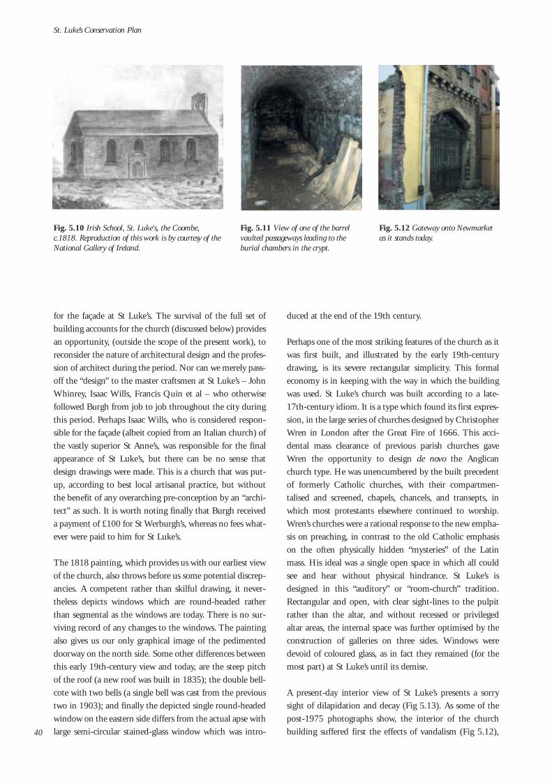
for the façade at St Luke’s. The survival of the full set ofbuilding accounts for the church (discussed below) providesan opportunity, (outside the scope of the present work), toreconsider the nature of architectural design and the profes-sion of architect during the period. Nor can we merely pass-off the “design” to the master craftsmen at St Luke’s – JohnWhinrey, Isaac Wills, Francis Quin et al – who otherwisefollowed Burgh from job to job throughout the city duringthis period. Perhaps Isaac Wills, who is considered respon-sible for the façade (albeit copied from an Italian church) ofthe vastly superior St Anne’s, was responsible for the finalappearance of St Luke’s, but there can be no sense thatdesign drawings were made. This is a church that was put-up, according to best local artisanal practice, but withoutthe benefit of any overarching pre-conception by an “archi-tect” as such. It is worth noting finally that Burgh receiveda payment of £100 for St Werburgh’s, whereas no fees what-ever were paid to him for St Luke’s.
The 1818 painting, which provides us with our earliest viewof the church, also throws before us some potential discrep-ancies. A competent rather than skilful drawing, it never-theless depicts windows which are round-headed ratherthan segmental as the windows are today. There is no sur-viving record of any changes to the windows. The paintingalso gives us our only graphical image of the pedimenteddoorway on the north side. Some other differences betweenthis early 19th-century view and today, are the steep pitchof the roof (a new roof was built in 1835); the double bell-cote with two bells (a single bell was cast from the previoustwo in 1903); and finally the depicted single round-headedwindow on the eastern side differs from the actual apse withlarge semi-circular stained-glass window which was intro-
duced at the end of the 19th century.
Perhaps one of the most striking features of the church as itwas first built, and illustrated by the early 19th-centurydrawing, is its severe rectangular simplicity. This formaleconomy is in keeping with the way in which the buildingwas used. St Luke’s church was built according to a late-17th-century idiom. It is a type which found its first expres-sion, in the large series of churches designed by ChristopherWren in London after the Great Fire of 1666. This acci-dental mass clearance of previous parish churches gaveWren the opportunity to design de novo the Anglicanchurch type. He was unencumbered by the built precedentof formerly Catholic churches, with their compartmen-talised and screened, chapels, chancels, and transepts, inwhich most protestants elsewhere continued to worship.Wren’s churches were a rational response to the new empha-sis on preaching, in contrast to the old Catholic emphasison the often physically hidden “mysteries” of the Latinmass. His ideal was a single open space in which all couldsee and hear without physical hindrance. St Luke’s isdesigned in this “auditory” or “room-church” tradition.Rectangular and open, with clear sight-lines to the pulpitrather than the altar, and without recessed or privilegedaltar areas, the internal space was further optimised by theconstruction of galleries on three sides. Windows weredevoid of coloured glass, as in fact they remained (for themost part) at St Luke’s until its demise.
A present-day interior view of St Luke’s presents a sorrysight of dilapidation and decay (Fig 5.13). As some of thepost-1975 photographs show, the interior of the churchbuilding suffered first the effects of vandalism (Fig 5.12),
St. Luke’s Conservation Plan
40
Fig. 5.10 Irish School, St. Luke's, the Coombe,c.1818. Reproduction of this work is by courtesy of theNational Gallery of Ireland.
Fig. 5.11 View of one of the barrelvaulted passageways leading to theburial chambers in the crypt.
Fig. 5.12 Gateway onto Newmarketas it stands today.

then in 1986 a fire which destroyed the ceiling, roof andwestern gallery. All of this was compounded by almost twodecades of subsequent neglect, during which time thebuilding lay abandoned to the elements and the debilitatingeffects of nature. A view from the west end facing east (Fig5.13), demonstrates the clear single-room openness of thespace as discussed above. Galleries which were on threesides at the beginning, were reduced to a single westerngallery as a result of a fall in population towards the end ofthe 19th century. The remains of the 1899-1900 additionof the barrel-vaulted, square-planned apse on the east endsurvive; the now-blocked semi-circular window must havebrightened-up considerably the large chamber of the
church. The gable on the east end (which was reduced in
height in 1835 but not replaced) shows evidence of theoriginal “compass” ceiling as well as the later flat ceilingwhich replaced it in 1900. The Anglican introduction ofceilings in preference to open roofs was made for acousticalreasons.
This present-day view also shows the recently cut-back veg-etation which some months ago filled the church to rooflevel. The surviving stubs of these trees are lodged inbetween the cruciform area of floor tiles which survives inthe centre of the church. The remainder of the floor wastimber, now rotted away, and the plants took root in thedeep piles of earth used to fill the spaces over the barrel-
vaulted crypts. Looking towards the opposite end of the
Understanding the Place
41
Fig. 5.13 Thepresent day interi-or of St. Luke's.
Fig. 5.15 Interiorview facing east.The open natureof the single-vol-ume space isapparent.(RepresentativeChurch BodyLibrary)
Fig. 5.14 Thechurch as it waspost-1975, alreadysuffering the effectsof vandalism.(Reproduced cour-tesy ofRepresentativeChurch BodyLibrary)
Fig. 5.17 Presentday interior viewlooking west.Evidence of thegallery can nolonger be seen.
Fig. 5.19Exterior view ofwestern gable.Note the randomrubble on thelower portion ofthe wall and thecoursed block-dressed stoneabove the eaves.
Fig. 5.18 Theremains of thecruciform area offloor tiles are stillvisible.
Fig. 5.16 Interiorview facing westtowards thegallery.(Reproduced cour-tesy ofRepresentativeChurch BodyLibrary)

church all signs of the final western gallery have disap-peared. For some reason the western gable had been re-built(the difference in masonry pattern is more obvious in anexternal view) when the ceiling was replaced in 1899-1900(Fig 5.19). A single bellcote was introduced around 1900when the pair of bells were recast into one larger one.
5.3 Historical Introduction
The parish of St Luke the Evangelist was established in theearly 18th century in response to the burgeoning develop-
ment of an area south-west of the earlier city parish of StNicholas Without. St Luke’s was one of a number of parish-es established by an Act of Parliament (6th Anne, c. 21) of1707 which was a response to the expanding populations inseveral of the city parishes (Fig 5.20). As a result a newparish of St Mark (to the north-east of Trinity College) wasto be formed from lands on the eastern half of St Andrew’sparish, while an entirely new parish of St Anne was to beformed on the lands being developed by Joshua Dawsoneast of Grafton Street. The combined parish of StCatherine, St James & St John Kilmainham on the south-western edge of the city was also to be re-divided. Finallythe increasing population in the fast developing industrialzone in the south-western part of St Nicholas Withoutparish, then catered for in the overcrowded north transeptof St Patrick’s Cathedral, was to be served by the new parishof St Luke. The 1707 Act resulted in the construction of several newchurches in the early decades of the 18th century. While theprincipal that these parishes were to be created was estab-lished by law, the new parishes would not come into effect
until the deaths or retirements of the incumbent ministersof the parishes to be affected by division. As a result theactual building of the new churches was staggered. StMark’s, for example, was not begun until 1729 and notcompleted until the 1750s. On the other hand some otherchurches, not associated with the Act, were also begun inthe early years of the 18th century (see full list in the open-ing paragraph of this essay). The vicar of St NicholasWithout was the dean of St Patrick’s cathedral, the parishbeing in the gift of the cathedral chapter. At this time thedean of St Patrick’s was John Stearne (the immediate pred-ecessor of Jonathan Swift). Stearne was appointed bishop of
Clogher on the 1st of May 1713, and the record of the firstChristening in the parish of St Luke’s, long before a churchwas built, also dates to May 1713, confirming that theintentions of the Act had been carried out. The first cess, orcollection of tithes for the new parish, with the building ofthe new church in mind, was carried out during 1714.Building works began in early 1715 and were completewhen the church was consecrated on October the 8th,1716. The speed by which the church was completedreflects the overall simplicity of its design and the limitedfinancial means at the disposal of the new parish.
5.4 Building Accounts
One of the most remarkable surviving artefacts associatedwith the early-18th-century church is the very rare full setof original building records for St Luke’s now in the archivesof the Representative Church Body in Churchtown. Thesewere entered into the Churchwarden’s Account books in1717. They appear to be a complete transcription of all of
St. Luke’s Conservation Plan
42
Fig. 5.20 Brookings map of 1728 illustrating parish boundariesestablished by the 1707 Act of Parliament.
Fig. 5.21 ‘Stone work and Brick Work done for the Rev'd Mr.Anthony Dopping at St. Lukes Church on the Coomb by Cap.tBurghs order’ (Reproduced courtesy of Representative Church BodyLibrary).

the accounts and receipts associated with the buildingworks, which until then must have been kept together as abundle of loose papers. These building accounts cover theperiod of the building works themselves, for the most partcarried-out from February 1715 to the Autumn of 1716,but also include a full account of parish income and expen-diture, associated with the construction of the church, fromthe date of the first parish cess in 1714. The accounts (seeappendix) allow us a very detailed insight into the completecampaign of building works, the leading practitioners andchurch officials who were involved, and the way in whichthe works were organised and priced. Records of this detail,pertaining to a still-standing building of such a date, are avery rare survival, and add considerably to our understand-ing of this church and church building in general duringthe early decades of the 18th century, as well as the build-ing trades of that time. They give a context and lend an his-torical depth to the surviving monument of St Luke’s whichin turn is an addition to its significance.
The majority of the accounts are recorded on pages 55-69of the Churchwarden’s account books, with a number ofmiscellaneous accounts to do with mainly later smallerworks, interspersed amongst the earlier pages, these latterbeing recorded there contemporaneously. The larger collec-tion, on pp. 55-69, is a later transcription of a more or lesscomplete set of building accounts. These include a fullaccount and description of each part of the building works,for example the works of the masons, the works of the stonecutters, the work of the carpenters etc., and then a secondset of copied receipts which are a verification of theaccounts themselves. The last pages are reserved for a fullincome and expenditure (with summary accounts of the
works done and references to the pages on which they aremore fully recorded) for the completed job. This allows usto see not only how much the whole job cost, but also how,and from whom, the funds were raised. All of the workswere measured, and signed-off as such, by the “measurer” (akind of contemporary quantity surveyor) George Wheeler.These were approved throughout by Thomas Burgh, andoften recorded as carried out according to “Cap’t Burgh’sorder”. Payments were made on occasion by the Archbishopof Dublin, William King (one of the prime movers in thechurch-building campaign associated with the 1707 Act),the vicar, Rev’d Anthony Dopping (a.k.a. Dobbin), andmost usually by the Churchwarden George Edkins.
5.5 Building of St Luke’s
While some of the lands upon which the church was builtmay already have belonged to the dean & chapter of StPatrick’s cathedral, the accounts show that three furtherplots of land were bought from a Mr Winterbotom, a MrLynn and Mr Vivers, and from a Mr Buckeley, to a totalcost of £263. This ground was already occupied so thatsome materials were salvaged from the houses which werecleared away, and these were re-used in the construction ofthe new church. £55 worth of masonry (cleaned bricks andstone) went to Mr Quin the bricklayer and Mr Caldbeckthe mason, and a further £35 worth of re-usable timberwent to Isaac Wills the master carpenter.
The actual building works began with the digging of foun-dations, and the clearing and carrying away of the earthfrom the area which was to be the vaults. This work was car-
Understanding the Place
43
Fig. 5.22 One of the original pages where the final accounts arefigured up. (Reproduced courtesy of Representative Church BodyLibrary)

ried out by John Crenell (a.k.a. Crannoly) and his associateHugh Burne. The first payment made for these works wason the 19th of February, 1715, “towards subsisting thelabourers that diggs & carrys away the earth of the valts”.Paid directly to the labourers, it is likely that this was an endof week payment, made immediately after the commence-ment of works, and it gives us our start date for the build-ing.
Work on the masonry walls of the crypts, and in turn, of thechurch itself, began soon afterwards. The elaborate grid ofpassages and chambers which make up the crypts was cov-ered by sophisticated brick barrel vaults. This work was car-ried out by the master bricklayer Francis Quin, and themasonry work throughout the church was done under thesupervision of William Caldbeck. Quin is known to haveworked on a number of commissions with the SurveyorGeneral, in the Library at Trinity college, at Dr Steevens’Hospital and at St Werburgh’s Church which was begunduring 1716 while St Luke’s was still under construction.Caldbeck also worked on the library in Trinity Collegealong with the stone cutters Moses and Hugh Darley.Payments to Quin and Caldbeck, are made in the Spring of1715, and then again in the Winter of 1715/16, which mayreflect two discrete campaigns of work. The complete worksincluded the construction of the church walls, the buildingof the vaults, laying in of quoins, and in the winter, the con-struction of the gables, the curtilage walls, and a brick wall“near the church”.
The stone carving was carried out by the master masonJohn Whinrey (or Whinery) whose work can still be seen ina number of surviving 18th-century Dublin buildings,
including, most notably perhaps, the east window of StMary’s Church in Mary Street. Made a freeman of the cityof Dublin in 1678, there is a record of his laying hearths inthe Tholsel in 1685. He is reputed to have built the steepleat the Royal Hospital Kilmainham after William Robinson’sdesigns in 1702, and he also worked with Burgh on manyother Dublin commissions including St Werburgh’s Churchand St Mary’s. Whinrey seems to have begun work on StLuke’s in the autumn of 1715, signing his first receipt forpayment on the 2nd of September. His work included“black stone” (Dublin Calp) quoins, black base and plinthstones, a white stone (Wicklow Granite) frontispiece (thenow obscured north doorway), the window surrounds,moulded steps and the internal flags. There is a reference toa head and keystone for the frontispiece, although thewhole pediment has disappeared. Other works, for whichpayments were received the following Spring, included cut-ting stones for the steeple, cutting holes for window bars,and putting up eight hooks for doors. It is unfortunate thatthe single most important piece of work carried out byWhinrey at St Luke’s has not only been covered over by theout-of-place Victorian porch, but has lost its segmental ped-iment as well. Despite the loss of the pediment there maybe an argument for removing the later incongruous porchto reveal and perhaps restore one of the few surviving worksof such an important early-18th-century craftsman (asreflected in Policy 16 of this Plan).
The carpenter Isaac Wills must have begun his work on theroof of the church some time during the winter of 1715,although a payment of £126 for timber was received by himas early as February 1715. The next payment “on acc’t ofCarpenters work done at the Church” was signed for, by
St. Luke’s Conservation Plan
44
Fig. 5.23 One of the Calp windowsurrounds – the work of master masonJohn Whinrey.
Fig. 5.24 The Victorian porch thatcovers over the original north doorwayby John Whinrey.

him, in January 1716, most likely a month or more sincehis crew had actually begun construction there. Wills wasalso a veteran of the Old Library at Trinity College, work-ing with Darley the stonecutter and Francis Quin the brick-layer under the direction of the Thomas Burgh. He alsoworked on St Werburgh’s and is thought to have carried onat the Old Library after Burgh’s death in 1730. The cost ofthe roofing alone at St Luke’s, “72 square & half of roofingat £5 per square” which came to £362 10s, was one of thelargest single bills in the construction of the church. Willswas also responsible for the “Cumpas” [sic] ceiling at “20sper square”. This unusual shallow vaulted timber ceilingwas plastered over. It would be replaced some 100 or soyears later by a horizontal compartmentalised ceiling – per-haps the acoustics of the arched form, whatever of its phys-ical condition, was not as satisfactory as first hoped.Apparently Wills also inserted an impost moulding underthe ceiling and modillion eaves on the exterior, whichapparently had survived until before the fire of 1986. Histeam was also responsible for fitting a trapdoor into the ceil-ing for the bell ropes and at floor level another for interioraccess into the vaults, otherwise entered through an exteri-or doorway on the south side of the church. He also fitteda number of door cases, and two “pair of doores to theChurch”.
There is no sign in this set of records of an account for theconstruction of the vestry, which has survived today inruined form. It was brick built, with a corner fireplace anduntil the fire in 1986, this single chamber, on the easternend of the south wall, preserved the only remnant of origi-nal early-eighteenth-century joinery in the building. Arecord for the 17th of November 1716 entered into an ear-
lier part of the Churchwarden’s volume, records the “fetch-ing of bricks from Lock Smilly [sic] Chimney” which werethen cleaned for re-use. These may have been for a brickboundary wall or for the vestry, which was, besides thevaulting in the crypts, the only brick portion of the churchbuilding. However Brooking, a cursory map at the best oftimes, does not indicate the existence of such a southernprojection in its 1728 plan of the church, its first represen-tation being on John Rocque’s 1756 map. Another omis-sion from the accounts is one for the construction of thegalleries. A required element in any Church of Irelandchurch at this time, they were almost certainly includedfrom the beginning. The stair rails with their barley-sugarbalusters, most likely belonging to these first galleries, werere-used in an altered position, for the stairs to the recon-structed galleries of 1862.
The joinery in the rest of the church, and perhaps in thevestry too, was carried out by a Mr Ray who was responsi-ble for the pulpit, reading desk, altar and pews. None ofthese features has survived so it is not clear what form theytook. Perhaps Ray built a three-decker pulpit, which incor-porated the reading desk, pulpit, and a seat for the clerk, ofthe type known to have survived in the church until the19th century, when it was illustrated in Welland andGillespie’s plan of 1862. A Mr Waters was responsible forplastering and “ceiling the church”, and he was also paid afurther £29 7s 8d for “painting the pulpitt alterpiece [sic]etc.” Other miscellanea include £44 10s to William Fordfor a pair of bells, which hung in the double bellcote on thewest gable of the church built by John Whinrey. A further£51 18s 6d was paid to Mr Jeffords for the branches (can-dleholders) and candlesticks, giving us a sense of how
Understanding the Place
45
Fig. 5.25 The remains of the church vestry as it is today.The corner fireplace and chimney are still standing.
Fig. 5.26 The vestry pre-1975. At least some of the early-18th century timber panelling had survived the fire, butthis early joinery was lost to theft and vandalism.(Reproduced courtesy of Representative Church BodyLibrary)
Fig. 5.27 Detailof the barley-sugarbalusters of theoriginal stair rails.(Reproduced cour-tesy of the IrishArchitecturalArchive)

expensive it was to light such a space in the 18th-century.
Finally the building records give a very clear account of thetotal income and expenditure. The final cost of the churchcame to £2046 14s 1/2d. Total income was £2046 15s 6d,leaving a favourable balance of 1s 2 1/2d. The most signif-icant portion of this income was a gift of £1200 from the“then Dean of St Patrick’s” John Stearne. This contributionis just short of 60% of the total price of the construction ofthe church, and puts the contribution of £50 each fromDublin Corporation, from the Lords Justice and theCouncill (the government of the day) and from ArchbishopWilliam King, into context. While the parish of St Luke’swould, like its parent parish of St Nicholas Without, remainin the gift, and under the control of the chapter of StPatrick’s Cathedral, there are some grounds for surmisingthat the £1200 was a personal benefaction made by thedean himself, before his elevation to the bishopric in 1713.The language of the account states quite specifically that themoney came from Stearne, without any mention of thecathedral chapter. Stearne, who was a very wealthy ecclesi-ast, made a series of very large donations to a wide range ofcivil and church bursaries at the time of his imminentretirement as dean, and indeed throughout his later life,many of which greatly exceeded the amount contributed toSt Luke’s. Money was also raised through a series of annualtithes, made on the parishioners, with the construction ofthe church specifically in mind. The first Cess (an abbrevi-ation of assessment) was made in 1714 and came to £10018s. A further £152 was raised in 1715 and again in 1716,while an even £200 was raised in the final year 1717. A fur-ther £90 was gained from the selling of materials salvagedfrom the old houses as the site was cleared for the newchurch.
5.6 Later developments
Like any building, domestic, industrial or civic, a churchwith more than two-hundred-and-sixty years of continuedoccupation is likely to undergo many physical alterationswhich will change the original appearance of the building.St Luke’s is no exception. These alterations are often a resultof changes in fashion, and of aspiration. In the context of achurch building, these may reflect ideological as well asliturgical developments. The concept of the Anglican box orauditory church, as designed by Wren, underwent its great-est transformational pressures during the middle of the
19th century as a result of the emerging beliefs first articu-lated in England by the Oxford Movement, later alsoknown Ecclesiologists. This group of Oxford scholars pro-moted a philosophy, within the Anglican tradition, whichnevertheless sought to revise many of the elements ofCatholic worship which had been lost by the severe tenetsof later-17th-century Protestantism. Some of the traditionsof, what was considered, medieval piety were revived. Thisbrought about a desire to revive not only elements ofCatholic piety, but an architecture which both reflected thatway of life and provided a suitable vehicle for a revised litur-gy. These early-19th-century “medievalists” were importantharbingers of the medieval or Gothic revival which was toinfluence so much of subsequent 19th-century design, inCatholic architecture as much as in Anglican. It has beenargued that all who built churches after the 1840s, set outto “design buildings that would express the architecturaland liturgical ideal of the middle ages”. Those who held-outagainst this development and clung stringently to the moreaustere tradition are often referred to as “low-church”. Theparishioners of St Luke’s, it might be argued as a result ofthe influence of those within the congregation who were ofHuguenot, and hence originally of Calvinist extraction,remained steadfastly low-church throughout much of theirhistory. As a result it was only during the very last years ofthe 19th century, with some tentative steps in 1883, and bymeans of the comprehensive changes made during 1899-1901, that the congregation of St Luke’s finally succumbedto a movement which everywhere else had been changingthe approach to church design for over a half century. 3
A brief survey of some of the more important changes madeto the church fabric will provide a conclusion to this essay.
1789 – Gallery repairsDue to the dilapidated condition of the north transept of StPatrick’s Cathedral, the congregation of St NicholasWithout had been sharing the Lady Chapel in the cathedralwith the French community who had worshipped theresince the late 17th century. However because of the contin-uing problems of space a decision was made to unite withtheir former brethren in St Luke’s, where the two parishesproposed to worship together once again. New galleries onthree sides, which were partially funded by a contributionof £90 by the visitors, were constructed to this end.However this union was short-lived and the St Nicholasparishioners were to return shortly afterwards to the cathe-dral.
St. Luke’s Conservation Plan
463. The issue of the Huguenot community, and the extent to which they played a part in the history of St Luke’s, was discussed in the pre-
vious chapter on St Luke’s in section 4.5.

1827 – roof repairsA surviving churchwarden’s notice records that it was“found necessary to strip a portion of the roof of the saidchurch and also to cleanse and paint the interior”. Thechurch was to be closed for seven weeks to facilitate theseworks, and services were to be carried out “in St NicholasWithout”. The exact nature of these repair works is not cer-tain, and as we shall see the roof was completely replacedsome eight years later. However an earlier letter from thearchbishop, formally brought to the attention of thechurchwarden’s of St Luke’s the necessity to make a specialcess on the parishioners for essential maintenance workwhich was to cost £113 2s. The temporary nature of theseworks is indicated by comparing these monies with thebudget which was secured by the parish some eight yearslater for the total replacement of the roof.
1835 – new roofLewis, in his 1837 Topographical Dictionary of Ireland,records that St Luke’s church had been re-roofed in 1835:just two years earlier. He also records that this was done onthe basis of a grant from the Ecclesiastical Commissioners(established in 1833) for £1,029 13s 6d. If we are to trustthe c.1818 painting in the National Gallery of Ireland, itappears that the pitch of the roof was significantly reducedby these works.
1862 – changes in response to the permanentreunion with the St Nicholas Without congregationBecause of renewed difficulties with the badly maintainednorth transept of St Patrick’s Cathedral, the parish of StNicholas Without was re-united for good with its old off-shoot, the parish of St Luke’s. It was from this year that the
new parish became known as the parish of St NicholasWithout and St Luke’s, although the church would alwaysremain dedicated to St Luke, the Evangelist. A number ofalterations were made to facilitate the larger congregation.The works were carried out by the well-known mid-19th-century firm of Welland and Gillespie, responsible forchurches in Derry, Killybegs, Castlebellingham andMulhuddard amongst others. A plan of the proposed worksto be carried out by the architects has survived (Fig 5.28),as well as a schedule of works recorded on an EcclesiasticalCommissioners’ pro-forma, and a manuscript license fromthe archbishop for the works to be carried through. The factthat the three-decker pulpit is recorded on the plan in thecentre of the church, blocking a clear view of the altar, isindicative of the continuing “low-church” approach toliturgy and the central importance of the word of God andthe sermon. The most significant alterations were made atthe west end, principally in order that the capacity of thegalleries might be expanded, and so that more room on theground floor might be used for seating. The 1847Ordnance Survey internal plan of the church (Fig 5.29),shows a ground-floor stair lobby at the rear of the churchwhich took up a considerable depth of space from the backwall. Welland and Gillespie’s 1862 plan (Fig 5.28) shows amore efficient management of the space, putting two singleflights of stairs on either side of the back wall. This necessi-tated moving the western entrance to the stair lobby to thewest end of the north wall. The former door was re-fitted asa window, with a new window on the other side of the westwall to match it. Both the later window and the new door-way on the north side have granite surrounds, contrastingwith the calp limestone ones elsewhere. The pews, bothwithin the galleries and on the ground floor were re-
Understanding the Place
47
Fig. 5.28 Welland and Gillespie's 1862plan showing alterations to rear of church.(Reproduced from John Crawford, St.Catherine's Parish Dublin 1840-1900;portrait of a Church of Ireland communi-ty)
Fig. 5.29 The 1847 Ordnance Survey plan of St.Luke's showing ground floor stair lobby.
Fig. 5.30 One of the granite windowsurrounds.

arranged for greater efficiency in order to increase capacity.
1883 – internal changesA number of changes were carried out at this time, some inresponse to a reduction in numbers, despite the recentarrival of the St Nicholas Without congregation, and somewhich indicate the first faltering steps towards a moreEcclesiological approach to church design as discussedabove. Of the latter, the most significant change was theremoval of the three-decker pulpit, and its replacement bya pulpit and reading desk on either side of the altar. Thisasserted, for the first time at St Luke’s, a new importance for
the altar space and what went on there. The old-style pewswith doors, as well as their associated system of rental, wereremoved, and replaced by more democratic open woodenseating. The north and south galleries were also takendown, and the western, as it appeared before the fire of1986, was renewed. It is possible that the Victorian porch,which does not appear on the OS map of 1847 nor theWelland & Gillespie map of 1862, was introduced at thistime, covering as it did the original granite-carved portal, inthe centre of the north entrance façade.
1899-1900 – major worksThe most radical changes to the church over the years werethose made in the last year of the 19th century and the firstof the 20th. They were carried out by James Franklin Fuller,a celebrated author and actor, as well as architect, who wasresponsible for some of the more spectacular Irish medievalrevival architecture of the later years of the 19th century.His new and remodelled buildings include KylemoreAbbey, Clontarf Castle and Ashford castle as well as somere-design work at Farmleigh in the 1870s. His work at St
Luke’s was the first which radically altered the single cham-ber Wren-like arrangement of the church, principally by theaddition of a square-planned chancel with a barrel vault onthe east end. However this was classically modelled andthere is no hint of medievalism at any stage. Paired Tuscancolumns support the arch and are connected by a pulvinat-ed frieze to Ionic pilasters on the side and rear walls while aminor order of Tuscan pilasters support an engaged arcade.At the rear of this new space was inserted a large-scale semi-circular window with a coloured glass depiction of Christwalking on the waves, donated by local factory owner JohnParkes in memory of his deceased wife Ellen (Fig. 5.33).
This was the first and only coloured glass to be introducedinto what was until then an otherwise austere, traditionallyAnglican, interior. The classical decoration has been badlycompromised by exposure to the elements. However thedamage to the columns uncovers a rare view of the mannerin which they were manufactured – the Tuscan columns aremade up of lath and plaster (Fig 5.35) which surround acore of iron, which in turn was the structural element whichactually carried the arch above. This unusual early-20th-century approach to applied classical decoration should befully recorded before any changes are made to it. As well asthis extended chancel area, a new stone altar was intro-duced, again underlining the new emphasis on the liturgyof the Eucharist. A new flat, compartmentalised ceiling forthe main body of the church replaced the earlier vaultedone, and it is possible that it was at this time that the west-ern gable was re-built. Unlike the gable on the east end,there is no evidence of the scar left by the compass ceiling,and the masonry pattern differs considerably from that ofthe masonry below it.
St. Luke’s Conservation Plan
48
Fig. 5.31 The altar space pre-1975
Fig. 5.32 The western gallery as itappeared before the fire of 1986.(Reproduced courtesy of RepresentativeChurch Body Library)
Fig. 5.33 The Parkes stained glass window.(Reproduced courtesy of RepresentativeChurch Body Library)

1903 – new bellA new single bell was cast from the metal of the two previ-ous ones. This meant too that a new single bellcote wasneeded, and it is likely that it was constructed using someof the granite blocks carved by John Whinrey’s workshop tobuild the first one. The new bell which is now stored in StPatrick’s Cathedral was inscribed “To the Glory of God andin Memory of the coming of the Huguenots 1685”.
5.7 St Luke’s Church in the 20th Century
St Luke’s, like many Church of Ireland parishes in the innercity, underwent a slow decline from at least the middle yearsof the 19th century, during a time when an emerging mid-dle class moved in large numbers out to the newly develop-ing suburbs which formed satellites outside of the city core.St Luke’s suffered this decline perhaps more than most, inthat its once thriving industrial working class was replacedby a greater number of the very poor, unskilled and oftenjobless. However the parish continued in existence until1975 when the doors of the church were finally closed. In1948, a visit made by H.A. Wheeler and Maurice Craig,found little to compare St Luke’s with the great Dublinchurch interiors such as St Mary’s or St Michan’s. The oldstairs with their (re-used) barley-sugar balusters was noted,as was the very fine organ (installed in 1837) with carvedand gilded wooden cherubs. The fine panelled vestry (nowin ruins) had also survived then as the only remaining evi-dence of the first 18th-century joinery in the building.Craig mentions some 16th- and 17th-century furnishingsthere such as a “chest of perhaps the latter part of the XVIthcentury, and a set of fine chairs of circa William III”.
The final service in the church was the HarvestThanksgiving Service which took place on the 19thSeptember 1975. The parish had been subsumed alreadyinto the St Patrick’s Cathedral Group of Parishes, where itremains represented to this day in their Select Vestry, andwhere worship is still carried out at the church of StCatherine and St James, Donore Avenue. In 1981 thechurch was temporarily leased to a publishing company, butwas taken back by the parish because of ongoing lack of careand the extent of vandalism being carried out on the churchand in the grounds. However in 1986, disaster struck whenthe roof of the church and the greater part of the interior
were destroyed by a fire, believed to have been caused mali-ciously. In 1990 the Representative Church Body sold theproperty to Dublin Corporation, subject to a covenant (seeappendix), for a nominal price of £5. The church and itsgrounds have remained (unused) in the hands of theCorporation (Dublin City Council) to this day.
Understanding the Place
49
Fig. 5.34 Example of the classical decorationas it survives today.
Fig. 5.35 The lath and plastercolumns enclose structural iron stan-chions.
Fig. 5.36 The bell and bellcotebefore the bell was removed to St.Patrick's Cathedral. (Reproducedcourtesy of Representative ChurchBody Library)

6.0 The Contemporary Context
“architecture, like all other cultural objects, is not made justonce, but is made and remade over and over again each timeit is represented through another medium, each time its sur-roundings change, each time different people experience it.”1
St. Luke’s is at a point of change. For the last 17 years it hasbeen dormant. Physically, the building and site haveregressed and, at the same time, recognition and awarenessof its meaning and value have weakened. The urban contextof St. Luke’s has seen considerable change during this time.1986, ironically, is a seminal year in the urban regenerationphenomenon which Dublin has undergone in recent years.This was the year of the first Urban Renewal Schemes,launched under the Finance Act and which have con-tributed so much to the physical shape and social characterwhich Dublin’s city centre exhibits today.
St. Luke’s is located within one of these urban renewal areas– the Liberties/Coombe Integrated Area Plan – and is,along with the adjacent empty site to the east of St. Luke‘s, a ‘designated site’ carrying tax incentives2. The objectivesfor the entire site include the retention and refurbishmentof the former church building and graveyard with a new,mixed use (ground floor street commercial, upper floors res-idential), building of maximum 4 storeys on the empty site.
The proposed use for St. Luke’s is community/institutional.Elsewhere in the 1998 Integrated Area Plan (IAP) thispotential use is expanded upon: “The development of a flag-ship heritage and cultural building incorporating St. Nicholasand St. Luke’s [sic] Church would act as a magnet to drawtourists into the heart of the area and generate local demandfor shops, restaurants and guided walks.” Further, under theKey Conservation Objectives the IAP invites “proposals …for the rehabilitation” of St Luke’s Church, “for appropriatecultural/community use”.
The IAP for the Liberties/Coombe was prepared by DublinCorporation (now Dublin City Council), under the 1998Urban Renewal Scheme and is one of five prepared forDublin City. It is a statutory plan with the objective tobring about sustainable urban regeneration by integratingphysical, social and economic interventions to address thekey issues in the area. The Liberties/Coombe area wasselected for targeted urban renewal because it was consid-ered an area in decline, both physically and in socio-eco-nomic terms.
This decline can be traced to the lack of investment in thearea, the gradual obsolescence of the traditional industries,the social engineering plans of 50’s and 60’s which movedmuch of the indigenous population to the new social hous-ing areas outside the historic centre all leading to what canbe described as the “doughnut” effect3.
St. Luke’s Conservation Plan
50
Fig. 6.1 St. Luke's in its current context.
1. From Strangely Familiar (1996): eds. Iain Borden, Joe Kerr, Alicia Pivaro, et al.: Routledge, London.2. Extended to 31 July 2006 in the December 2003 Budget.3. The doughnut effect is used to describe the physical form which Dublin City took on during this period of decline and disinterest in
the historic centre, i.e., development on the outer ring with a hollow core in the centre.

However, as in all such stories it is easy to fall into the trapof simplification and biased readings. A recent TourismStudy of the area4, consulted a broad sample from the localcommunity/public sector and the general tourism sector.Descriptions of the area ranged from ‘the old and ancienttrue heart of Dublin’ with a ‘strong sense of community” to“ Liberties is a village in the city” and “The history and cul-ture of this part of the city distinguishes it from other partsof the city”. The settled community was considered by farthe greatest historical and cultural strength of the area,above its history and architecture.
The demise of St. Luke’s runs parallel with the general
decline of the surrounding area, both physically and eco-nomically. Much of this can be traced to the series of roadschemes which originated in the 1957 Planning Schemedrawn up by the then Dublin Corporation with the subse-quent imprimatur of the Myles Wright Advisory Plan of1967 which visualised little or no prospect for city centreDublin, setting up the current low density urban form ofthe city, developed around the primacy of private transportfor personal mobility. An Foras Forbatha’s The DublinTransportation Study (DTS), 1971 & 1972, reaffirmed thismodel of development, laying down recommendations fornew roads and road widening schemes. While finance wasnever adequate to implement in full the recommendationsof the DTS, it did instigate much planning blight. The Cork Street/Coombe relief road survived however, insuccessive City Development Plans and the Dublin
Transportation Initiative (DTI) included it in its strategy toreduce traffic congestion in the City. It was adopted byDublin City Council as a dual carraigeway in 1994 follow-ing a preliminary Environmental Impact Study (EIS) whichexplored a number of options. This EIS also identified alarge site, including St. Luke’s for redevelopment.
The subsequent EIS for the Relief Route refers to this his-tory of policy led blight in its introduction “Proposals...havebeen the subject of much debate for more than 40 years.Various schemes have come and gone over that time giving riseto much uncertainty and a lack of confidence in the area as awhole. The dereliction and neglect as a result of this uncer-tainty is much in evidence along the route and in the area gen-erally”. It is worth noting other comments in this EIS whichrelate particularly to St. Luke’s. Prepared in 1998 (prior tothe 1999 Planning and Development Act, which put theprotection of the built heritage on a statutory footingincluding the curtilage of a protected structure), the preser-vation of St Luke’s Church is noted under the section onCultural Heritage, however the resultant radical alterationto the building’s historic setting and context is not specifi-cally addressed. The EIS indicates that “Existing local land-marks (St. Luke’s, Church, The Widow’s Houses and St. Briget’s[sic] School) will become more prominent along the route. Thisprovides an opportunity to emphasise their function as such.On the other hand, if not adequately considered, they could beisolated in meaningless setting”.
Understanding the Place
51
Fig. 6.2 The junction opposite St. Luke's, where the new road meetsthe Coombe.
Fig. 6.3 There are several run-down and underused properties inthe area surrounding St. Luke's.
4. Tourism Scoping Study for Liberties/Coombe and Kilmainham/Inchicore, carried out by Tourism Development International forDublin City Council (2003)

Bringing things up to the present, one of the current initia-tives for the area, which seeks to redress the legacy of theprevious 40 years of planning for a relief road, is Cork Street– A Regeneration Strategy: Recreating a Street (draft urbandesign framework, co-authored by the City ArchitectsDivision and the Planning Division of Dublin CityCouncil). This sets out proposals, guidelines, ideas, images,etc., on how to “recreate a lively people-friendly city street...avibrant, mixed-use city street with new buildings of the high-est possible quality of a scale sufficient to contain the consider-able width of the new road, providing a safe, convenient andpleasurable environment for pedestrians, cyclists and publictransport users…” It lays down a strong physical frameworkand architectural/urban design vision and promotes thereclamation of the public realm which places priority on thepedestrian. The strategy addresses St. Luke’s in the contextof its wider setting, its “historic hinterland” centred on thefine urban space at Newmarket. Defining this area asNewmarket and St. Luke’s Quarter, it identifies“Newmarket as the major urban space within this quadrant ofthe city and St. Luke’s Church – a strong historic form – as thefocal points.”
Dublin City Council have been involved in further study ofthe Newmarket area. In this a different approach to urbanregeneration is being taken which advances the use of thespace ahead of any physical reordering or major interven-tion.
It sees Newmarket as a site of intervention and a host forvarying events and activities which will support and encour-age new socio-spatial creations. The physical interventionor ‘architecture’ will follow and can reflect the character
which will evolve as the space is used and re-used. This is aradically different understanding of city making to that ofAbercrombie whose 1914 and 1941 plans, with S. and A.Kelly, adopted a strong Beaux-Art style – urban design asbig architecture.
Allied to these regeneration strategies Dublin City Counciland NCAD (National College of Art and Design) are devel-oping a joint project taking the new relief street/St. Luke’sAvenue as a site of exploration, intervention and installa-tion. Consideration may be given to including St. Luke’swithin this scheme.
While the new relief road has caused significant physicaldisruption to the area around St. Luke’s, the recent plansand initiatives, described above, have brought a renewedfocus on the area and generated a broad level and, indeed,range of interest. From a commercial perspective opportu-nities for development, many of them endowed with taxdesignated status, have opened up. Already, the severednorthern half of the historic St. Luke’s site, that containingthe former widow’s almshouses, is currently being devel-oped as a mixed use scheme with the shell of the historicalmshouse building retained as part of the scheme.Unfortunately the former relationship with St. Luke’s canno longer be read physically and the new scheme does littleto reflect this link.
The site directly west of St. Luke’s and spanning betweenthe new relief road and Newmarket, is being developed as afour storey mixed use complex. The residential upper floorswill overlook the grounds of St. Luke’s which brings thepossible positive benefits of security and neighbourliness.
St. Luke’s Conservation Plan
52
Fig. 6.4 The Widows Alms House site is currently under redevelop-ment. Unfortunately, the old Parkes sign, another fragment of theCoombe's history, has been removed.
Fig. 6.5 The new relief road, which has caused significant disrup-tion in the area.

However, the expression and maintenance of the upper lev-els will directly impact on the environmental quality of St.Luke’s – put simply, if well handled this can make a positivecontribution to the future use and enjoyment of St. Luke’s.
The site immediately east of St. Luke’s is being developedby Dublin City Council to accommodate an extension toSt. Brigid’s National School. The development of this siteneeds to be considered in conjunction with the futuredevelopment/restoration of St. Luke’s – it can set up access,both vehicular (controlled) and pedestrian to St. Luke’s andframe it as a focal point.
There is a strong level of activity and interest amongst localcommunity and representative groups who have made a sig-nificant contribution to this Plan 5. There is a consensusthat the future use and restoration/adaptation of St. Luke’sshould incorporate public access to the site and includeuse(s) of direct community benefit. There is a perceptionthat recent development in the area has almost exclusivelybenefited individual developers and has resulted in thegradual gentrification of the area. St. Luke’s is seen as anopportunity to ‘give something back’ to the local commu-nity and to translate the potential of the building and thesite into a use(s) which equally reflects the valued historyand meaning of the site and provides a purposeful addition
Understanding the Place
53
Fig. 6.6 Brabazon Row, linking Newmarket with the new reliefroad.
Fig. 6.7 St. Luke's viewed from Newmarket. This view will disap-pear once the development on the adjacent site is complete.
5. A more detailed account of views and concerns is contained in Appendix B along with written submissions.
Fig. 6.8 Map showing areas reachedwithin approximate times, by walk-ing from St. Luke's. This is providedto illustrate the proximity of St.Luke's to the City Centre and itsmajor landmarks and venues.

to the area. The criteria for assessing what might be a goodor successful use needs to reflect the broader aspects of‘community gain’ - place making, cultural and socialimprovement, security, environmental benefits, stimula-tion, acknowledgement of past histories (and there are sev-eral) – issues which are not so easily tabulated and gobeyond simple economic evaluations.
Presently the strategic location of St. Luke’s is not widelyappreciated in terms of its proximity to the City Centre. Ananalysis of the area covered within 5, 15 and 30 minuteswalking from St. Luke’s shows just how close it is to centralareas and landmarks.
A recurring theme in all the development/urban regenera-tion plans and policies of Dublin City Council is that oflinkages and connections. By opening up historic and newroutes greater permeability of the city block is achieved andthe pedestrian is encouraged to walk and explore new terri-tories. These connections are made by forming walkwayswhich can be pleasant and/or short-cuts bringing the pedes-trian and, increasingly, the cyclist, to other areas or the spe-cific sites and activities. Thus, St. Luke’s might accommo-date one use amongst a trail of associated uses within theLiberties/Coombe area, which would also serve those out-side the immediate locality.
The location of St. Luke’s, straddling the new road and thefine urban space of Newmarket allied to an appropriate use,makes it strategic in facilitating some of these potential con-nections. The diagram below illustrates the extensive net-work of ‘quiet routes’ which currently exists in and aroundSt. Luke’s. What stands out is the gap between the network
north and south of St. Luke’s, created by the new road.However, the future landscaping and accessibility of St.Luke’s, planned in conjunction with the vacant site directlyto the east, could bridge this gap to a great extent.
The dominance of the spire of St. Patrick’s Cathedral fromany vantage point on the site, indeed the area, emphasisesthe connection, which extends beyond the physical,between St. Luke’s and this significant monument and citylandmark.
While the religious function of St. Luke’s is now historic,following it’s de-consecration in 1976, the connection stillobtains. The graveyard and crypt contain many burialsincluding those re-interred after the demolition of St.Peter’s on Aungier Street. It is still a sacred place. Further,the Covenant which formed part of the transfer of owner-ship from the Representative Church Body (RCB) toDublin City Council on 7 November 1990 sets out a seriesof conditions as to the future use of St. Luke’s. ThisCovenant is, therefore, one of the primary informants ofthe future of St. Luke’s. The Covenant is included in theAppendices to this Conservation Plan, however, it is worth-while setting out the more significant clauses here:
“Corporation [Dublin City Council] hereby covenants with theVendor as follows:
Not to call the premises hereby conveyed by any name includ-ing the words Old Church or Church or by any nomenclatureof an ecclesiastical connotation.
Not to use or permit to be used as premises hereby conveyed or
St. Luke’s Conservation Plan
54
Fig. 6.9 Map showing quiet routes (grey) in the vicinity of St. Luke's. The heavily trafficked routes (dashed) exacerbate the problem of severancebetween the areas south and north of St. Luke's.

any part thereof for any religious purpose or as a public dance-hall or for gambling or bingo or for the sale or consumption ofalcohol or for any base or unworthy purpose.
Not to erect any buildings on the subject property unless priorto the commencement of any building works or redevelopmentall human remains are exhumed by proper order and cremat-ed at the expense of the Corporation [Dublin City Council].
Not to use the crypt of the former church known as St. Luke’sunless prior to such use or development all human remainslocated in the crypt have been exhumed by proper order andcremated at the sole expense of the Corporation.
The purchaser shall ensure that until such time as the crypt ofthe former church of St. Luke’s is used or developed that samewill be secured and sealed to preclude any unauthorised entry.”
The Covenant is a legally binding agreement, however, ifboth parties to the Covenant are in agreement to a particu-lar change, then, legally, it can be changed. Thus, for exam-ple, the restrictions on the future use of St. Luke’s for reli-
gious functions, might be possible, subject to both the RCBand Dublin City Council reaching an agreement. The pos-sibility of St. Luke’s housing a church again is quite realistic– there has been a growth in demand for permanentaccommodation for some of the ‘new’ religions, which havecome to Dublin under the recent influxes of foreign immi-grants. There are already a number of religious bodieswhich have expressed an interest in St. Luke’s.
Whatever the future use of St. Luke’s might be, and thereare many possible uses which are addressed in theRecommendations and Policies, there are many clues aris-ing from a study of the historic and contemporary contextsof the area and the site in particular.
Understanding the Place
55
Fig. 6.10 The spire of St. Patrick's Cathedral is visible from manyparts of the area surrounding St. Luke's.

7.0 St. Luke’s Church: Condition
7.1 General
St. Luke’s has been unoccupied and unmaintained since thefire of 1986. Thus it has undergone 17 years of deteriora-tion, exposed to weather, and invasion of a wide variety ofvegetation which has grown unchecked until recently. It hasalso been subject to vandalism and theft, the former main-ly directed at the burials in the crypts, the latter probablyoccurring soon after the fire, when there is photographicevidence of significant amounts of the vestry wall panellingand the gallery stairs surviving. Despite this, what survivedstructurally following the fire has generally survived to thepresent day, albeit in a poorer condition. The vestry hasprobably suffered the greatest deterioration. The site andbuilding are described in more detail below:
7.2 The Site
As has been described already, the new relief road has had adetrimental impact on the site, chiefly in the loss of theintegrity of its historic setting and context. By a combina-tion of years of neglect when the land, reserved for the newroad, was effectively sterilised or set-aside and the subse-quent difficulties, since the road was built, in accessing thesite, the condition of the site has gradually declined to itspresent overgrown state.
While paths are generally overgrown, there is considerabledocumentation, including photographs and information
form historic survey maps to show how the grounds werelaid out.
The site contained a graveyard, however burials within thesite are extensive and extend considerably beyond the des-ignated graveyard area. Over the years of disuse the tomb-stones have become displaced from burial sites and whilemost are stacked in the open area adjacent to the formersacristy, there are also several scattered amongst the growth.Burial records exist therefore it would be possible to com-pile an inventory of surviving tombstones and relate this tothe records.
The boundaries of St. Luke’s changed relatively little duringthe history of the Church of Ireland’s occupation – the mostsignificant change obviously resulting from the new reliefroad . The surviving boundary walls of any historic or archi-tectural merit are on the east and south of the site. These
St. Luke’s Conservation Plan
56
Fig. 7.1 Aerial view of St. Luke's, before new relief road was built. Note the overgrowncondition of the site. While the heavy growth has been removed from within the mainchurch space, it is still extensive elsewhere.
Fig. 7.2 Growth in graveyard to south(rear) of church.
Fig. 7.3 Extract from 1847 Ordnance Survey Map showing layoutof St. Luke's.

walls are surviving external walls from earlier industrialbuildings. While the form and alignment can be tracedback to the 1756 Rocque map, it is likely that what survivesis post Rocque. There is, however, a plaque to a JamesWallace and his wife Deborah, dated 1792, which is builtinto the eastern boundary wall. This plaque, which needsrepair, may well be a later addition to this wall, as evidencedby the rough brickwork surrounding it.
Generally, the surviving historic boundary walls appearstructurally sound, although access to inspect the walls tothe rear (south) of the site is difficult, due to the extensivegrowth. There has been considerable mortar loss and organ-ic growth is widespread. Some of the walls are partially ren-dered with former window opes blocked up. The easternboundary wall also formed the external wall of the formerParke’s warehouse. This was burnt by fire in the 1980’swhich may have caused some damage to the Dublin Calpstone.
It would be desirable to retain and repair the surviving his-toric boundary walls, however, it would be acceptable tomake specific interventions to the wall to facilitate accessand connection to the adjacent (east) site. This should onlybe carried out in the context of the redevelopment of theadjacent site and the refurbishment of St. Luke’s. It mayalso be necessary to form considered openings in the east-ern boundary to facilitate access to St. Luke’s.
The boundary to the west of the site will be new – the for-mer wall having been removed during the current construc-tion works. The detail design of this wall needs to addressthe narrow entrance here from Newmarket. It should con-
tribute to an inviting entrance to St. Luke’s. It may be anappropriate site for artistic intervention – tying in withsome of the current and proposed initiatives for the generalarea and possibly taking the various stories of St. Luke’s andthe general area as a point of departure. In the meantime,this boundary is being temporarily shored while the con-struction works are ongoing below ground level.
The pallisade fence to the new, northern, boundary to therelief road is aggressive and, while it allows visibility of thesite, it de-values the site for the passer-by.
The other notable feature within the site is the unusualentrance gate from Newmarket. The fine wrought iron gateis set within a castellated brick frame, the slightly projectingcastellated top section supported on stone corbels. Thebrick has been rendered with a dense cementitious renderwhich, having failed, is now coming off in sheets. The ren-der has caused some surface and salt damage to the yellowbrickwork although this is repairable. The remaining render
Understanding the Place
57
Fig. 7.4 Exposedpart of tombstonein undergrowth.
Fig. 7.5Tombstonesstacked againstboundary wallto rear, adjacentto former sac-risty.
Fig. 7.7 Palisadefence to northernboundary a hos-tile appearance topassers by on St.Luke's Avenue.
Fig. 7.8 Front ofbrick entrancewith wroughtiron gate atNewmarket.
Fig. 7.6 Wall plaque on east-ern boundary wall whichreads:Eheu. Fugit. Ineparabile tem-pus Beneath lie the Remains ofJames Wallace who Departedthis Life Feb 13th Anno Dom.1792 & also those Of Deborahhis wife (quo bii Jan 3) Anno.1792

should be removed and the brickwork repaired and re-pointed using a compatible lime mortar. The iron gate hasbeen temporarily removed to facilitate temporary proppingof the brick surround, while the construction works on theadjacent (west) site are ongoing. On completion of theseworks, the iron gate should be repaired and reinstated with-in the restored brick surround.
7.3 Building Condition
7.3.1 Roof:The only surviving section of roof remaining is over theearly 20th century square ended apse. This is a slated pitchroof, in poor condition. Most of the slates have been lostand the timber is likely to have decayed.
7.3.2 WallsExternal FaçadesThe main, external, walls of the building survive to eaveslevel. The calp limestone, of which the structure is built isdurable and has therefore withstood the attack of weatherand organic growth, which it has been subjected to duringthe previous 17 years. It appears that the structure was neverrendered. The building may have been limewashed –which, although not as effective as a render finish, wouldhave given some weathering protection. This gives furtherindication of the relative poverty of the parish – other con-temporary churches were generally partially rendered withsignificant areas of façade treated with dressed stone.
Some structural consolidation is required, particularly atwall tops, where weathering and vegetation will have desta-
St. Luke’s Conservation Plan
58
Fig. 7.9 Inner,rendered face ofNewmarketentrance gateprior to temporaryremoval of gateand proppingwith concreteblockwork.
Fig. 7.10 Detailof ironworkwhich is quitedelicate.
Fig. 7.11Surviving sectionof roof on east endapse – in poorcondition.
Fig. 7.12 1818painting of St.Luke's Churchwhich appears todepict an unren-dered rubblemasonry structure(reproduced bycourtesy of theNational Galleryof Ireland).
Fig. 7.13 North (front) façade showing vegetation at wall tops andgenerally loss of mortar in joints with detail of bellcote below, show-ing loose stone and open joints. The bell, which was cast in 1903,from the two original bells of 1714, is now displayed in St. Patrick'sCathedral.

bilised the coping stones. These should be lifted and re-bedded in lime mortar, in conjunction with generalrepointing of the walls and removal of vegetation andorganic growth. Coping stones to the West gable arenotably loose and could become further dislodged duringthe adjacent construction works. This also includes the bell-cote where joints are open.
The section of the east gable wall, which was partially ren-dered in modern times, probably as part of the works asso-ciated with forming the apse here, should be removed.
Internal Facades The internal condition of the walls indicates much loss ofsurface detail and finishes. The wall plaques and memorialswere removed from the church by the RCB, following itsde-consecration in 1975, to the parish church of St.Catharine and St. James at Donore Avenue. According toCanon John Crawford, most of these were subsequentlydestroyed. There is a complete inventory of the plaquesretained in the RCB archives. Other elements which nolonger survive include the timber dado panelling, gallerystructure and stairs, internal partitions and internal joineryin general.
A considerable amount of wall plaster survives with the dec-orative painting scheme still apparent. There is little deco-rative plaster of note.Perhaps the most interesting part of the interior which sur-vives in situ is the unusual early 20th century classical chan-cel insertion. Although now in a increasingly deterioratingcondition, the main part has been protected by the surviv-ing section of roof over the apsed end. The unusual con-
Understanding the Place
59
Fig. 7.14 Sectionof dense cementrender on the eastgable with somecement pointingunder – probablydate to early 20thcentury construc-tion of apse.
Fig. 7.15 Internalview of church,showing considerableamount of internalplaster surviving, theeast end chancel andthe scar where thedado panelling wasremoved.
Fig. 7.16 Detail ofchancel showing construc-tion of cast iron columnstructure with lath andplaster covering.
Fig. 7.18 (below) General view of classically inspired design of eastchancel apse. The blocked up semi-circular ope above the blind arcade to the rearof the apse formerly contained the Ellen Parkes memorial stainedglass window. This is currently in the possession of the YMCA onAungier Street (who occupy the site of the former St. Peter'sChurch). The YMCA propose to incorporate this window into theirplanned future extension.
Fig. 7.17 View of southdouble pilaster where ironcolumn structure has beencompletely exposed.

struction of a cast iron core with a lath and thickly coatedplaster finish to the round side pilasters can be seen wheredecay has exposed this structure. In the context of so littlesurviving of the building’s decorative interior and the factthat this part of the church is relatively intact, the retentionand repair of the chancel should form part of any futureworks.
Vestry WallsLittle survives of the vestry structure. Essentially the shellwith outer walls and opes indicate the form of the vestry.The raised and fielded panelling which was part of the orig-inal fabric and, from a study of the photographic record inthe Irish Architectural Archive, survived the 1986 fire, isentirely gone. The future redevelopment/refurbishment ofSt. Luke’s is likely to involve the replacement of this struc-ture with a new building, which should respect the foot-print of the original.
Window and Door OpesApart from the eaves and gable coping stones and the plinthcourse stone, the window and door surrounds are the onlydressed stone used in the building. These are simple, pri-marily limestone (calp) surrounds with little or no decora-tive mouldings.
The granite surround to the early, possibly original centraldoorcase on the north façade is quite fine. The later, ren-dered, Victorian porch detracts from this doorcase, bothstructurally and aesthetically (refer to Policy 16 as set out insection 12.5 of this Plan). It appears as if the granite to thisdoorcase may originally have been coated with a decorativefinish, possibly a limewash as there are surviving fragments.
It is recommended that analysis is carried out to determinethe precise nature of this early coating. The temporary ironpanel closing off entry to the church here is corroding andshould be replaced.
There is one granite window surround on the west façade –all others are limestone calp. The condition of thestonework is generally sound, although there is some sur-face lamination, fissures and cracks and most joints requirerepointing. Some of the sills, which are quite flush to thefaçade, are cracked and chipped. Centuries of environmen-tal pollution is also contributing to decay and it is recom-mended that appropriate cleaning of the stone is carried outto remove any harmful chemicals. This is a general concernwith regard to the masonry structure.Window opes have been blocked up rather crudely withconcrete block (Fig 7.24), in places the iron glazing bars
St. Luke’s Conservation Plan
60
Fig. 7.19 Surviving shell of vestryshowing wall of later (west) additionwith door frame and small ope.
Fig. 7.20 Surviving brick shell of original vestrywith corner fireplace, and timber lintels to doorand window opes surviving. Note tombstonesstacked against boundary wall in the background.
Fig. 7.21 Detail of calp window surround.
Fig. 7.22 Awkwarddetail of junctionbetween early granitedoor surround onnorth façade and laterVictorian porch. Notetraces of surface deco-ration on granite inaddition to loss ofdetail and surfacedelamination of stone.

survive (Fig 7.25). These have corroded with consequentialdamage to the stone surround. The main north door hasbeen blocked up with a steel panel, which is severely cor-roded. A temporary steel door to the door ope at the westend of the north wall provides the only access to the mainground floor space.
FloorThe ground floor of the main body of the former churchrests on the brick vaults of the crypts below. From the evi-dence that survives, it appears this floor was timber board-ing on timber joists with a central and cross aisle finished in
tile. A trough running the length of the central aisle appearsto have contained a heating pipe. Historic photographsshow a metal grille over this trough, which would haveallowed the heat rise within the church space.
The chancel is raised by two wide steps above the main navefloor level, typical of such churches, with a third step up tothe altar occurring at the line of the 20th century apse. Thechancel and altar area were finished in a polychromaticmosaic tile pattern, which dates from the 20th centuryworks.
The floor is poorly preserved – the tiled aisles are still canstill be noted and the chancel mosaic work survives in smallfragments. Nothing of the timber floor survives, which isnot surprising given the fire and the years of growth andexposure to the elements. The brick vault to the crypts,which provides the floor structure, is open to the elementsand is also suffering damage due to the extensive vegetationroot system which persists, despite a recent clearance of theinterior by Dublin City Council.
A hole, large enough to allow a person through has beenbreached through the floor on the south side. This is likelyto have been the route for the intruders who desecrated theburials in the crypt.
CryptsThe crypts are, without doubt, one of the most interestingarchitectural features of St. Luke’s. They are extensive,numbering 30 in total. Well built brick barrel vaults, theyhave survived in good condition to the present day. A small number of deliberate interventions have been car-ried out, mostly during the recent history of the church.
Understanding the Place
61
Fig. 7.23 Steeldoor to onlyoperating accessto church interi-or in north wall.
Fig. 7.24Concrete blocksto window opeon north façade.
Fig. 7.26 View ofinterior showingoutline of tiledcentral aisles run-ning in bothdirections.
Fig. 7.25Window opes onsouth façade areblocked up on theinside with revealand survivingiron glazing barsexposed to exter-nal.
Fig. 7.28 Detailview of tiled aisle.Growth, althoughcleared recently,still persists andhas taken root inbrick structure.
Fig. 7.27 Viewthrough ope infloor showingbrick vault con-struction tocrypts.

These mainly arise from building services installations andthere are a number of pipe runs within the crypt whichbreach the brick structure. These run at high level and lowlevel – it is unclear what the high level pipes serve, althoughthey do appear to be sewer pipes. The low level pipe run-ning in the east end may have taken waste from the vestry.All pipes are cast iron except for a small section of upvc pipewhich connects from the low level pipe and runs eastthrough an untidy hole in the structural wall. It may con-nect to a void space under the east apse.
This void space may have housed a boiler, which wouldhave served the underfloor heating trough, mentionedabove, to the main church space. (This would explain thebrick stub chimney stack on the east gable). This space,which was not surveyed, is only accessible from the externalarea east of the vestry. This is presently blocked up.
The heating trough was formed by breaching the crown ofthe line of central vaults, running east-west, and a steel baseplate to this trough can be seen from the crypt space. Thisis severely corroded.
The ground surface in the crypts is compacted earth and isgenerally sound. The north west end of the crypt space is,however, quite damp, with water lodging on the ground. Itis not possible to say if this is a recent manifestation or if theground here was always damp. The area should be moni-tored to assess the extent and nature of this problem, beforeany amelioration works are carried out.
The conditions within the crypts did not allow a thoroughexamination of this space. Following installation of tempo-
rary lighting, additional ventilation and the controlledremoval of the burials and other architectural fragments ofnote, a further survey should be carried out to ascertaincondition. From the limited inspection which was under-taken, it does appear that the building fabric is generallysound. The brickwork may need some repair and re-point-ing, particularly where breaches have been made or corrod-ing iron has created failure of brick.Access to the crypt is via a set of stone steps in the southwall. These steps are limestone with the top 2 no. granite,which suggests they may have been added at a later stage.The entrance ope is blocked up by debris and the earlyiron gate no longer functioning. This is the only means ofentry and exit from the crypts to carry out remedialworks.
St. Luke’s Conservation Plan
62
Fig. 7.29 Crypt interior – circulationspace on south side with fragments ofreredos to the former St. Peter'sChurch Aungier Street leaningagainst walls.
Fig. 7.30 Crypt interior – view tocrypt entrance with corroded metalbar protecting entrance.
7.31 Entrance, from south externalarea adjacent to vestry, to chamberunder east end apse – currently inac-cessible.
Fig. 7.32 Entrance tocrypts from south side ofchurch. Iron gate toentrance needsrepair/replacement.

Understanding the Place
63
Fig. 7.33 Ground Floor Plan,taken from outline survey car-ried out on 15 July 2003.
Fig. 7.34 Plan of Crypts, takenfrom outline survey carried outon 15 July 2003.

8.0 Archaeological Issues
8.1 Introduction
This section states the issues concerning the archaeologicalheritage aspects of the church of St. Luke’s. It excludes anydiscussion of the architecture of the standing structure. Thearchaeological heritage discussed here includes aspects ofthe building and it’s curtilage which are below ground, ormay not be visible. It also covers the issue of the burialsstored in the crypts.
The findings from some recent excavations, either withinthe site or in adjacent sites, is outlined first and this is fol-lowed by a more detailed description of the burials, address-ing burials within the graveyard/grounds – including thoseuncovered during recent excavations – and burials withinthe crypts. A brief explanation of the statutory context con-cludes this section.
8.2 Recent Excavations
Excavation of the Cork Street/Coombe relief road uncov-ered archaeological evidence for medieval agricultural activ-ity in the vicinity of St Luke’s. Plough strikes, aligned east-west, were apparent in subsoil (the lowest level). They werefilled with a soil which produced pottery of 13th - 14thcentury date. A key- hole shaped grain drier, which hadcarbonised grain, cut into subsoil. It had a stone- lined flueand chamber, and was associated with a clay- floored struc-ture. Pits and a ditch were also excavated in this area. Thissite lay down-slope of the church of St Lukes, where a thick
layer of medieval and post- medieval soils, probably repre-senting a plough lynchet, had accumulated.
The early post- medieval period is represented by a stone-lined well, timber water pipes, and a cellar. Similar materi-al, including the structural foundations as depicted onRocque’s map of 1756, was uncovered on the developmentsite immediately to the west of St. Luke’s. The ground levelof the buildings uncovered is considerably lower than thepresent level, indicating a considerable amount of build–upto the north of the church. None of the buildings uncov-ered appeared to have served any ecclesiastic function, andthere were no human burials on this site.
Structural foundations of the mid- 18th century were alsouncovered in a test excavation on the vacant, Dublin CityCouncil site immediately to the east of St Luke’s. Nomedieval soils survived on the latter site.
Medieval soils were exposed in test trenching of the formeravenue to St. Luke’s and at the Widow’s Houses site (105-109 Weaver St) in 1999 (licence 99E0560). Building workon this site is underway.
8.3 Burials
Burials within graveyard/grounds of St. Luke’sThe graveyard and the church were in use for burial from1713 to 1922. The Parish Register, now in the RCB library,records deaths from 1716 onwards. This would appear to bethe date from which burial started. The graveyard is shownin all maps as being confined and located to the south of the
St. Luke’s Conservation Plan
64
Fig. 8.1 Site location on Speed 1610,approximate.
Fig. 8.3 View of north-west corner of St.Luke's, showing boundary wall demolished.Archaeologists standing on 18th centuryground level to west.
Fig. 8.2 Rocque 1756, showing St.Luke's and location of 2001 excava-tions prior to construction of newrelief road.

church. However, a drawing of the church by Francis Place,dated 1818, clearly shows headstones on the north side ofthe church. None survive there today, although there is asingle burial plaque in the east wall of the graveyard.
Although St Luke’s is strongly associated with theHuguenots, earlier writers observed that there are noHuguenot names on the gravestones. (The FrenchGraveyard , or ‘cabbage garden’, off Kevin St, probably con-tained more Huguenots- these traditional plots may havecontinued past the establishment of the churchyard at StLuke’s). Brief extracts from both the burials register of StLuke’s and that of the Huguenot churchyard (the Frenchgraveyard) are included in the Appendices for contrast ofsurnames.
There were grave slabs from the 18th century in the church-yard. Several mentioned the trade of the deceased. Recordsin the RCB state that all graveslabs were moved to theprecincts of St Patrick’s cathedral prior to the church beingtransferred to Dublin City Council. While the inventory ofgraveslabs in the RCB is very thorough, there are severalslabs still on the site - several are stacked against the westboundary wall adjacent to the vestry and at least one slablies within the crypts space – further may be uncovered dur-ing future site clearance.
Recent graveyard excavations relating to thenew relief road
A section of the graveyard to the north of the church wasexcavated in advance of the Coombe relief road (location,
fig. 8.2). An infilled cellar was uncovered. The north wall ofthe graveyard, as depicted on the 1st edition (O.S) overlaythe infilled cellar. Therefore this wall is secondary. Fifty sixburials pre-dating this wall – i.e. pre 1840s – all respectedthe line of the main path from the Coombe to the church.All were in wooden coffins.
One hundred and nine burials post-dated the new enclo-sure wall. All were in wooden coffins, and were in shallowgraves, less than 100mm below present ground level. Onlyone had a grave marker.
Test excavation in front graveyard The test excavation carried out in 2001 in the front grave-yard also indicated the widespread presence of burials, at500mm below ground level. An infant placed in a tin boxat 60mm below the surface, was possibly interred as late asthe 1940s.
A full paleopathological report on the burials from thegraveyard excavated in 2001 is in preparation by aConsultant Osteoarchaeologist. It has been noted that therewas a high proportion of juveniles. It has been suggestedthat many of the burials may have resulted from deaths atthe nearby Cork St Fever Hospital.
Despite the construction of the new road, the main area ofthe graveyard of St. Luke’s remains intact.
Burials in CryptsSt Luke’s possesses extensive burial crypts, of limestone withvaulted red brick, which extend beneath the entire church.The entrance to the crypts, on the south side, is presently
Understanding the Place
65
Fig. 8.4 The area to the north of the churchthat was excavated in advance of the construc-tion of the new road.
Fig. 8.5 South-west area of crypts, showingarchitectural debris and human bone.
Fig. 8.6 Detail of disarticulated skullamongst debris.

open, and ramped with rubble, which includes grave furni-ture. There are grave slabs within the crypt itself, which mayhave been placed there by vandals. There is a considerableamount of architectural debris within the crypt, and strewnwithin this material, are human burial remains.
The human remains constitute both those originallyinterred within the crypts of St Luke’s and, in addition,burials which were exhumed from the graveyard of St Peter’schurch in Aungier St. in the 1980s and were stored in thewesternmost crypts, in what was considered at the time tobe a secure location. Both groups of burials have been scat-tered by vandals throughout the crypts, and disarticulatedbone is intermixed with rubble and architectural fragments.
The remains relating to St. Luke’s appear to be housed in 3of the vaults, having been re-coffined following vandalismin 1986. These vaults have inscribed plaques over theentrances to them, with what is likely to be the initials ofthe burials contained within. The Church Of Ireland haveinformation confirming the identity of two of the remains– Richard Watkins (died 17 February 1852, aged 69) andCatherine Watkins (died 11 June 1859, aged 76). While theidentity of the other interments is not available, it has beensuggested that the vault containing the inscribed plaque, MS , may be that of Mark Saunders, or Mark Sanders, bothof who were Churchwarden for St. Luke‘s, the former thefirst, with a George Edkins, and the latter was churchwar-den in the late 18th century.
The poverty of the parish in general may account for thelow uptake of burials in the crypt (which has already beenreferred to in this Plan), as it is noted that most of the cryptsof St. Luke’s were empty, prior to the relocation of the St.Peter‘s burials.
The burials from the churchyard of St Peter’s, Aungier St(founded 1685) were exhumed by order of the RCB of theChurch of Ireland, prior to private sale of that site. Thework was carried out by Fanagans Funeral Directors in1980, under an exhumation licence. The resulting work hasbeen found to have been crudely carried out, by modernand archaeological standards. ‘Three hundred and six poly-thene bags of human bones, along with 31 timber crates,total representing c. 1,200 individuals, were taken to thecrypts of St Luke’s church, and stored there. In addition, 19lead coffins were placed here’ (Doyle 2001, 4). A block wallwas constructed to safeguard the bones. This wall has sincebeen breached, and the bones scattered over the south westarea of the crypts.The site of St Peter’s graveyard, Aungier St, was re- excavat-ed in 2003. On present evidence, and prior to the strati-
graphic analysis, the date of the burials which remained inthe graveyard of St Peter’s cannot be determined, due to thelevel of disturbance caused by the mechanical exhumationin 1980. More data may be forthcoming from theConsultant Osteoarchaeologist’s analysis of the remains.
The burials from St Peter’s which were placed in the cryptsof St Luke’s are jumbled, and uncontexted, and it would notbe possible to assemble the bones to individuals. In additionto the crude removal, and storage in groups in bags, theremains have been subsequently vandalised, and now con-stitute a vast charnel heap.
The 1990 Covenant relating to the transfer of St. Luke’s toDublin Corporation, (included in the Appendices), sets outthe Church of Ireland’s requirements for how both sets ofremains in the crypt are to be dealt with, in the context ofany future development of the site and/or crypts. This callsfor “exhumation, by proper order, followed by cremation, atthe expense of the [Dublin] Corporation”.
During the course of preparing this Conservation Plan, theissue of the future treatment of these remains was exploredwith the input of the Dublin City Archaeologist, theNational Museum, Department of Environment, Heritageand Local Government, a specialist ConsultantOsteoarchaeologist and the Consultant Team who preparedthis Plan. While the St. Patrick’s Cathedral Group ofParishes were not involved in any of the meetings with thepreviously mentioned bodies and individuals, they wereconsulted with The various reports emanating from thisreview are contained in the Appendices and the recommen-dations are incorporated in the Part Four of this Plan –Recommendations and Policies.
The main criteria which have informed the recommenda-tions have been
• the Covenant• acknowledgement that the remains are of people and
should be respected• the archaeological value or interest of the remains, bear-
ing in mind both their disarticulated condition and theguidance policies of the National Museum.
• the complete burial register which is available• the onerous Health and Safety implications of exhuma-
tion and examination.
St. Luke’s Conservation Plan
66

8.4 Archaeological implications for futuredevelopment of St. Luke’s
The conditions of the Covenant relating to the burials inthe crypt have been outlined, in some detail, already above.
Other issues concerning the continuous use of the site as agraveyard have archaeological implications. The main oneconcerns any potential construction. The remaining areas ofland associated with the church have all at different periodsbeen utilised as a graveyard. Removal of these graves wouldbe required by the Department of Environment Heritage
and Local Government and The National Museum, under
archaeological licence. This may be refused if extensive areasof burials are required to be moved, as there is a high levelof sensitivity regarding excavation of cemeteries, and stor-age of the remains. This means that ground-works of anykind in the vicinity of the church would be limited andpreferably shallow. Burials were encountered at a depth of60mm to 500mm in the area to the north of the church,except in the area of the original path to the church.
In addition, the policy of Dublin City Council at present isto avoid interference with in-situ remains on the site of aknown graveyard.
Understanding the Place
67
Fig. 8.7 1818 watercolour painting depictinggraveyard in front (northern) external area.(Reproduction of this work is by courtesy ofthe National Gallery of Ireland)
Fig. 8.8 Detail of 1756 Rocque mapshowing graveyard to rear (southern)external area.

9.0 Environmental Issues
9.1 Landscape
GeneralThe site consists of the roofless church, its front (northern)lawn/graveyard and its rear (southern) graveyard confinedbetween high walls and taking the form of an overgrownshrubbery. Large amounts of Buddleja (commonly knownas Buddleia, latin Buddleja) and other self seeded saplingsand bushes were removed from within the church wallsrecently and there is somewhat older dumping of soil, mostlikely related to the new road in front. The disturbed soilthere and near the adjacent (western) building site hasgrown a crop of weeds.
The SiteThe elevated open area to the front was formerly tree-lined.It shows traces of the original lawn in the abundance of redfescue grass Festuca rubra, ribwort plantian Plantago lanceo-lata and dandelion Taraxacum officinale. These grow withweedier species characteristic of bare ground such as thistlesCirsium vulgare, C. arvense, bindweed Calystegia sepium,cinquefoil Potentilla reptans, scutch Elytrigia repens, barrenbrome Anisantha sterilis and hedge mustard Sisymbriumofficinale. A few woody species occur, a small hawthornCrataegus monogyna and a broken elm Ulmus glabra andthere are two survivals from the church garden, Spanishbluebell Hyacinthoides hispanicus and soapwort Saponariaofficinalis. The latter is the only plant showing a possiblyassociation with the pre-existing industrial use of the area –soapwort was commonly used in the textile industry. The
variety observed at St. Luke’s seems to be a rather long-leafed form.
The rear (southern) graveyard is densely grown over withgarden and self-sown shrubs, among which the followingwere noted, Buddleja, sycamore Acer pseudoplatanus, fuchsia,lilac Syringa and evergreen spindle Eunoymus japonicus. Anopen corner persists close to the apartment block to thesouth of this area, where bramble Rubus fruticosus and reedgrass Phalaris arundinacea share the ground.
The high boundary walls which surround open space onthree sides provide a cool, tranquil shaded enclosure. Thisenvironment and the lack of any real maintenance sincethe mid-1970’s has resulted in this almost impenetrablethicket of native and volunteer species and ivy. Two hollies,Ilex aquilifolium var., possibly planted 30 to 50 years agoare of value. Bulbs such as snowdrops and daffodils, oftenplanted in graveyards and survivors of neglect, may also bepresent.
The site otherwise carries typical weed species of urbanwaste ground, among them tall rocket Sisymbrium altissi-
St. Luke’s Conservation Plan
68
Fig. 9.1 Front (northern) entrance avenue,early 20th century. (Reproduced courtesy ofRepresentative Church Body Library)
Fig. 9.2 Front (northern) area, dateunknown, but likely to date from prior tochurch closure. (Reproduced courtesy ofRepresentative Church Body Library)
Fig. 9.3 Front (northern) entrance avenue,date unknown, but likely to date from afterchurch closure. (Reproduced courtesy ofRepresentative Church Body Library)
Fig. 9.4 Front(northern) areaMay 2003 show-ing extensivegrowth and buildup of groundlevel.

mum, shepherd’s purse Capsella bursa-pastoris, cleaversGalium aparine, groundsel Senecio vulgaris and ragwortS.jacobea. Remains of a hedge along the access fromNewmarket Square shows bittersweet Solanum dulcamaraand rose-bay Chamerion angustifolium.
The BuildingThe church building has a new crop of weed seedlings onledges and the ground (since the recent clearance) but theseare of species widespread elsewhere. On the wall tops thegarden Wilson’s honeysuckle Lonicera mitida, cocksfootDactylis glomerata and Buddelja are established but thereare no old wall plants such as wallflower or valerian.
9.2 Wildlife
The rear graveyard provides cover for small birds, robin andblackbird were noted during the survey of the site carriedout in May 2003. Other birds noted in the building andaround the site were wood pigeon and feral pigeon (theseprobably nest on the higher ledges or windows of the roof-less building) in addition to swifts. The swifts do not appearto have been nesting as the absence of eaves and nestingholes make their breeding here unlikely at present. Therewas no evidence of bats found during the survey.
This informal and wild ‘garden’ provides a tranquil greenlung in an area much bereft of such amenities. On exami-nation of historic maps, St. Luke’s appears as a significantgreen space in what has been a densely developed part of thecity centre. It is also interesting to note, particularly on the1847 first Ordnance Survey map, the extent of ‘gardens’ in
the area. This makes the survival and continuation of thegreen space at St. Luke’s of greater importance.
In terms of unusual or significant flora and fauna, the onlyvarieties/species worth noting include the presence of soap-wort and the visiting swifts. These latter mysterious birds,would be a welcome urban feature if encouraged to nest, byfixing nestboxes to the walls.
Understanding the Place
69
Fig. 9.8 Growthwithin churchwalls prior toclearance, May2003.
Fig. 9.9 Churchinterior shortlyafter clearance ofgrowth.
Fig. 9.5 Rear (south) graveyard. Fig. 9.6 Rear (south) graveyard. Fig. 9.7 Aerial view of St. Luke's prior to construction ofnew road. This was also prior to clearance of growth fromwithin church walls (May 2003). Green area to front(northern) side of church has also been partially clearedand excavated to facilitate relief road.

9.3 Conclusion
The grounds of St. Luke’s provide a welcome green spaceand an important habitat for plant and animal life in thedensely built up area of the Coombe. The future use for thebuilding and site should be assessed against its impact onthese valuable environmental assets. It would appear appro-priate that a ‘best practice’ Graveyard Management Schemewould be implemented for St. Luke’s (refer toRecommendation E as set out in section 12.5 of this Plan).
St. Luke’s Conservation Plan
70
Fig. 9.10 Detail from Rocque's1756 Map
Fig. 9.11 Detail from 1847 OSMap
Fig. 9.12 Detail from 1886/87 OSMap.

“The power of place – the power of ordinary urban landscapesto nurture citizens’ public memory, to encompass shared time inthe form of shared territory – remains untapped for most work-ing people’s neighbourhoods in most cities...The sense of civicidentity that shared history can convey is missing. And even bit-ter experiences and fights communities have lost need to beremembered – so as not to diminish their importance.”1
10.0 Statement of Significance
The 1988 ICOMOS Charter for the Conservation ofPlaces of Cultural Significance, known as the Burra Charter,sets down the principles for assessing the cultural signifi-cance of an historic site. This charter defines cultural sig-nificance as “the aesthetic, historic, scientific or social values forpast, present or future generations”.
The ways in which and the reasons why St. Luke’s is a sig-nificant place are many and multi-layered. These relate toaspects of its history, its architecture, its archaeology, theenvironment within the site, the physical, social and cultur-al relationship to its urban hinterland and, not least, to itshistoric use and its potential for future use. An overview ofthese helps to define what it is that makes St. Luke’s special:
10.1 Uses and Associations
A repository of memory – a site of potential – a totem• Throughout its history, as parish church, St. Luke’s has
played an important role in the spiritual, social and cul-tural life of its parish and the broader community ofThe Coombe. It is only in recent times that this roleceased. However, despite the state of abandonment dur-ing the past 17 years, St. Luke’s has come to hold atotemic power within the area. It resonates stories of thepast and hopes of the present for the future. As such itis a site of rich potential and promise.
A historic landmark• Associated with the above, St. Luke’s is an historic land-
mark of social and cultural importance in an area whichhas experienced considerable change and extensive lossof physical fabric in recent times. As such the site is arepository for the area’s rich and unique history whichhas not yet been fully recorded or presented.
An institution of charity and education • St. Luke’s hosted and developed several buildings and
institutions which supported parish-led welfarethroughout its history. This tradition of social care,albeit primarily for those of protestant faith, is fondlyremembered and valued by the present community.
Significance and Vulnerability
71
Part Three: Significance and Vulnerability
1. Dolores Hayen, The Power of Place: Urban Landscapes in Public History, (Cambridge, Mass: MIT Press, 1995).

A public building• St. Luke’s was built for public access, it is a public build-
ing, currently in public ownership. In an area which ispredominantly in private, commercial and/or residen-tial use, this ownership is significant.
Huguenot associations• Although the active participation and involvement of the
Huguenots in St. Luke’s is not substantiated in theresearch carried out for this Plan, (note the burial regis-ter contains very few names of Huguenot origin), therehas been, for a long time, a strong sense of connectionbetween the two. This bond manifested itself in the ded-ication of the bell in to “..the Glory of God and in Memoryof the coming of the Huguenots 1685”.2 The association isgreatly valued within the local community.
10.2 The Site
A sacred place• The pre-eminent historical role of St. Luke’s is as a
sacred place of prayer and burial. Although de-conse-crated as a church, it is still a graveyard and the spiritu-al atmosphere persists and resounds. As a calm and pro-tected space, St. Luke’s can be a place of reflection andrespite.
A tiny green lung• Although overgrown, St. Luke’s is and always has been
an island of green space in a highly urbanised part of thecity. Historic maps show several other green spaces,albeit mainly private, in the immediate vicinity: today,there are very few such spaces in this area.
A connecting route• Straddling the new Cork St/Coombe relief road and
Newmarket, St. Luke’s connects the Cathedrals precinctof the historic city centre and the formerly vibrant, nowlittle used, area around Newmarket.
A new aspect• Although the new relief road has severed the historic site,
St. Luke’s today presents a much more prominent profileto the public realm. Where formerly the building washidden at the end of a narrow avenue and surrounded byhigh walls, its current setting transforms the buildinginto a focal physical landmark in the area.
Flora and Fauna• Although not abundant in unusual flora and fauna, St.
Luke’s does attract swifts, the indefatigable flyers, andsoapwort, a survivor from the traditional textile indus-try of the area, grows within the grounds. Some plantedshrubs survive from a time when the grounds weretended.
Gateway to Newmarket• The entrance gate to Newmarket, which was added
sometime between 1847 and 1886, is a distinctive piece
St. Luke’s Conservation Plan
72
Fig. 10.1 West elevation, St. Luke's.This view will be significantlyobscured by the development on theadjacent site.
Fig. 10.2 View of Newmarket looking east. Fig. 10.3 The historical view of St. Luke'sfrom the Coombe (pictured here in early2003) has now been lost with the develop-ment of the Widows Alms House site.
2 The original two bells were recast in 1906.

of streetscape onto Newmarket. In particular, the quali-ty of the wrought ironwork is quite fine.
10.3 The Building
• The church is a survival of early 18th century churchbuilding of which little remains in the City. As such it isa repository of contemporary construction and buildingskills. While of lesser architectural importance than someof the other contemporary churches in the City – St.Mary’s, St. Werburghs, St. Nicholas Without, – of par-ticular note are the fine granite door surround on thenorthern façade (now obscured by the somewhat crudeVictorian porch) and the quality and rarity of the crypts.
• One of the most remarkable surviving artefacts associat-ed with the church is the very rare full set of originalbuilding records for St. Luke’s. These provide a detailedand comprehensive insight into the building works, theleading practitioners and church officials involved andhow works were organised and priced. Records of thisdetail, pertaining to a still-standing building of such adate, are a very rare survival. They add considerably tothe understanding of St. Luke’s and contemporarychurch building as well as the building trades of thattime.
• The site is significant for its association with Sir ThomasBurgh, as architect, and other, known, skilled craftspeo-ple of the period, e.g., Issac Wills, Francis Quin andJohn Whinrey, who carved the front (northern) granitedoorway.
• The building is notable for the strict rectangular sim-plicity of its architecture, typical of such church build-ings of the late 17th/early 18th century and influencedby the churches of Sir Christopher Wren in London.This is reflected in the robust, functional and restrainedquality to the masonry, in accord with the soberstrength and clarity of the Anglican vision at the time.
• The crypts, a grid of 30 burial vaults are a importantand unusual architectural feature of the church. Builtwell, they survive remarkably intact.
• St. Luke’s is a survival from the John Rocque DublinCity map of 1756, arguably Dublin’s most importantdrawn record which traces the architectural and urbantransformation of Dublin in the 18th century to a cityof European significance. Within the area there are veryfew still standing structures which were recorded on thismap.
• The east chancel apse, which dates from the 1899-1900alterations, is an accomplished classical composition.The unusual construction of the Tuscan columns – lathand plaster surrounding a cast iron central columnwhich is fixed to a mass concrete base – is worthy ofrecording and retention. This is the only architecturalset-piece which survives. substantially complete, withinthe main church space.
Significance and Vulnerability
73
Fig. 10.5 The gateway with its finewrought ironwork.
Fig. 10.6 The fine and relativelyintact Classically inspired east chan-cel remodelled and extended in1899-1900. The unusual construc-tion of the double pilaster Tuscancolumns is notable.
Fig. 10.4 With the construction of the newrelief road, St. Luke's now has a more promi-nent position as a landmark in the area.

10.4 Urban Setting and Context
Cathedral Precinct – Church Quarter• St. Luke’s lies within the hinterland of the City’s histor-
ically and architecturally important cathedrals andforms, with these, a group of prominent landmarkchurch buildings. This group can be expanded toinclude the large number of other historic churcheswithin the general south-west inner city area to create alarger network of church buildings of interest.
10.5 Archaeology
BurialsThe value of St. Luke’s as a burial ground is notable fromthe extent of burials within the site, including those knownand recorded in the burial registers, and those numerous,unknown and unrecorded burials. The recent archaeologi-cal excavations at St. Luke’s have begun to record the latter,many of whom were juvenile and in shallow graves.
11.0 Issues of Vulnerability
In order to develop policies and recommendations for themanagement and protection of those aspects of St. Luke’swhich are considered significant, it is necessary to identifywhat has, what currently does and, what potentially couldadversely affect the significance of the site. This section setsout those issues which threaten the values noted in the ear-lier parts of the Conservation Plan. Some of these threatsare readily definable, others less tangible. Many are complexand prevail for varied reasons.
11.1 Issues of Use
11.1.1 Lack of Use• The decline of St. Luke’s follows to a great extent the
decline of the protestant population in the Coombe/Liberties area. The small congregation could not sustainthe original use. Without an active congregation, therewas little opposition to the relief road proposals and itsimplications for St. Luke’s. Having de-consecrated thechurch and leased the building for a number of uses, theChurch of Ireland eventually transferred ownership tothe then Dublin Corporation in 1990. At this point thesite had been unused since the 1986 fire. In this case,therefore it is the lack of use of St. Luke’s during the past17 years which contributes to its vulnerability. Unused,inaccessible and un-maintained, it has become de-val-ued.
St. Luke’s Conservation Plan
74
Fig. 10.7 View of St. Luke\s through IDACentre in Newmarket

11.1.2 Limitations for site development, building adaptationand use• Outside the footprint of the existing building structures
and the narrow entrance lane from Newmarket, the siteof St. Luke’s is almost completely covered with burials.The current policy of the National Museum and theDoEHLG is to refuse archaeological licences forremoval of burials from graveyards to facilitate develop-ment (other than major national infrastructure proj-ects). Further, the current stated policy of Dublin CityCouncil is to refuse planning permission to develop-ment on the site of a known graveyard. As long as theabove policies apply it appears any new use will berestricted to primarily within the existing building foot-print.
• The existing building is a Protected Structure. The moreimportant aspects of the building have been describedin Section 10 above and these will control the level andnature of intervention and adaptation permitted toaccommodate a new use.
• The Covenant sets out a number of non-permissibleuses for the building.
• There is presently very poor access provision to the siteand there are many difficulties in resolving this issue.Thus building work, maintenance and servicing of anew use will all present challenges to any future build-ing owners and users.
• Cumulatively, the above may be seen to place an exces-sive limitation on the future use of the building and as
a result, may mitigate against certain uses and users. Thepotential difficulty in finding a use which can workwithin these restrictions, and satisfy the policies andobjectives set out in Section 12, places a certain vulner-ability on the future reuse of St. Luke’s.
11.2 Issues affecting the Site
11.2.1 Defining the site• The integrity of the historic site has undergone radical
intervention and change following the construction ofthe new relief road: It has severed the site, creating two,separate and unconnected sites; the former relationshipbetween St. Luke’s and The Coombe is broken; theWidows Alms House, built originally as a school forpoor boys of the parish, no longer forms part of the site;the spatial organisation within the site has been re-ordered – no longer is the church enclosed and ‘hidden’within its own grounds, it now presents a street frontagein a most prominent and public manner. In coming toan understanding of the significance of the site at St.Luke’s a clear reading of what exactly is the site is prob-lemmatic: the contemporary definition of the site nolonger equates with the historic.
11.2.3 Condition and Presentation• The poor and overgrown condition of the site makes a
proper assessment difficult. The condition is in a con-tinual state of deterioration and if this is not checkedthen greater loss of important planting, building fabric,etc., is inevitable. Of particular concern is the potentialdamage to the Newmarket Gate, the surviving historic
Significance and Vulnerability
75
Fig. 11.2 The site is in a poor andovergrown condition.
Fig. 11.1 St. Luke's now sits on a raisedledge of ground above the new Coombe ReliefRoad behind inhospitable palisade fencing.
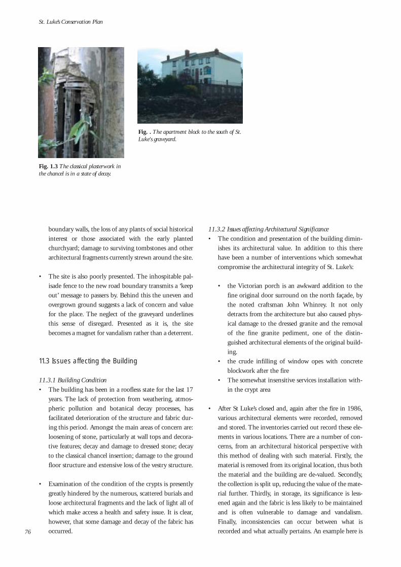
boundary walls, the loss of any plants of social historicalinterest or those associated with the early plantedchurchyard; damage to surviving tombstones and otherarchitectural fragments currently strewn around the site.
• The site is also poorly presented. The inhospitable pal-isade fence to the new road boundary transmits a ‘keepout’ message to passers by. Behind this the uneven andovergrown ground suggests a lack of concern and valuefor the place. The neglect of the graveyard underlinesthis sense of disregard. Presented as it is, the sitebecomes a magnet for vandalism rather than a deterrent.
11.3 Issues affecting the Building
11.3.1 Building Condition• The building has been in a roofless state for the last 17
years. The lack of protection from weathering, atmos-pheric pollution and botanical decay processes, hasfacilitated deterioration of the structure and fabric dur-ing this period. Amongst the main areas of concern are:loosening of stone, particularly at wall tops and decora-tive features; decay and damage to dressed stone; decayto the classical chancel insertion; damage to the groundfloor structure and extensive loss of the vestry structure.
• Examination of the condition of the crypts is presentlygreatly hindered by the numerous, scattered burials andloose architectural fragments and the lack of light all ofwhich make access a health and safety issue. It is clear,however, that some damage and decay of the fabric hasoccurred.
11.3.2 Issues affecting Architectural Significance• The condition and presentation of the building dimin-
ishes its architectural value. In addition to this therehave been a number of interventions which somewhatcompromise the architectural integrity of St. Luke’s:
• the Victorian porch is an awkward addition to thefine original door surround on the north façade, bythe noted craftsman John Whinrey. It not onlydetracts from the architecture but also caused phys-ical damage to the dressed granite and the removalof the fine granite pediment, one of the distin-guished architectural elements of the original build-ing.
• the crude infilling of window opes with concreteblockwork after the fire
• The somewhat insensitive services installation with-in the crypt area
• After St Luke’s closed and, again after the fire in 1986,various architectural elements were recorded, removedand stored. The inventories carried out record these ele-ments in various locations. There are a number of con-cerns, from an architectural historical perspective withthis method of dealing with such material. Firstly, thematerial is removed from its original location, thus boththe material and the building are de-valued. Secondly,the collection is split up, reducing the value of the mate-rial further. Thirdly, in storage, its significance is less-ened again and the fabric is less likely to be maintainedand is often vulnerable to damage and vandalism.Finally, inconsistencies can occur between what isrecorded and what actually pertains. An example here is
St. Luke’s Conservation Plan
76
Fig. 1.3 The classical plasterwork inthe chancel is in a state of decay.
Fig. . The apartment block to the south of St.Luke's graveyard.

with the graveslabs. The inventory places them in St.Patrick’s Cathedral. However, there are several tomb-stones in the grounds of St. Luke’s and in the crypt.
11.3.3 Vandalism • The fire which destroyed much of the building was an
act of arson/vandalism. Since the fire St. Luke’s has beenfurther subjected to vandalism. In its present unoccu-pied, unsupervised state, the place is vulnerable to fur-ther damage by vandalism.
11.4 Issues affecting Urban Setting and Context
11.4.1 Adjacent Development• After a long period of stasis, very much associated with
the protracted history of the relief road, recent years haveseen a number of new developments in the vicinity of St.Luke’s. While these schemes help to rebuild the area’ssocial and amenity infrastructure, there are some archi-tectural and urban design aspects which might have bet-ter addressed the particular context of St. Luke’s and thebroader urban framework:
• 1990’s residential scheme to south-east of St. Luke’s.This is an early apartment scheme which fills a largearea between St. Luke’s and New Row. The buildings are4 storeys adjacent to St. Luke’s and partially shade thesouth graveyard – this is not very noticeable due to thecurrent overgrowth here. This is one of the early ‘gated’communities and unfortunately, there was no provisionmade for a future pedestrian link, through the complex,between St. Luke’s and New Row.
• Mixed use development on the site immediately west ofSt. Luke’s. Currently under construction, the site liesbetween the new relief road and Newmarket. It willcontain a narrow first floor internal courtyard with bal-conies at upper levels, overlooking the grounds of St.Luke’s. The boundary is very tight to the west gable ofSt. Luke’s and this scheme will have a significant physi-cal impact on St. Luke’s, particularly the west gablewhich will become difficult to view. Located to the westof St. Luke‘s, evening sun in the grounds will be con-siderably reduced. It will, however, facilitate the partialreinstatement of ‘Skinner’s Alley’ - an historic alleywayconnecting Newmarket and The Coombe.
• Widows Alms House Site. The site, also currently underconstruction, was formerly part of the original site of St.Luke’s, containing the entrance from The Coombe andthe tree lined avenue to the church. The shell of theWidows Alms House, a Protected Structure, is beingretained and a new 4 to 5 storey, dropping to 3 to 4storey residential building will wrap around the newroad boundary. The layout of the scheme bears littlerelation to the historic footprints or the historic con-nection with St. Luke’s Church.
• These schemes were all planned before Dublin CityCouncil prepared their urban design strategy for newroad.1 This considers development as a composition ofbuildings, spaces and suitable uses, which can formurban spaces and streets, when planned in an integratedmanner. The lack of an overall plan which includes St.Luke’s and takes regard of its various aspects of impor-tance, has resulted in some loss of significance of the
Significance and Vulnerability
77
Fig. 11.5 The west gable of St.Luke's taken from the developmentsite, west of the church. This viewwill disappear on completion of thenew development – indeed only apartial view of this façade will bepossible.
Fig. 11.6 The view from the originalCoombe entrance to St. Luke's will shortly beclosed by the new development on the WidowsAlms House site.
Fig. 11.7 The rather 'hard' landscape envi-ronment of the new road.

historic site and, further, some loss of opportunities forthe re-integration of St. Luke’s.
• In this context, it is useful to address the ConservationReport as a tool to assist development. ConservationReports are now required for development affectingProtected Structures, as part of the planning permissionprocess. However, the prevailing approach to theConservation Report has been to prepare it in isolationto the design process and generally, after the majordesign decisions are made. This reduces theConservation Report to, effectively, an historic overviewand an inventory. The potential role of theConservation Report, therefore, as a design tool to assistin developing site plans, is not realised. If such anapproach had been taken on some of the sites adjacentto St. Luke’s, then perhaps design solutions, more sym-pathetic to St. Luke’s would have been developed. Thelack of such an approach increases the vulnerability ofhistoric sites, such as St. Luke’s.
1. Cork Street – A Regeneration Strategy: Recreating a Street:Draft Urban Design Framework.Dublin City Council (City Architects Division PlanningDepartment), April 2003
11.4.1 The New Road• The severance of the historic site of St. Luke’s by the
new relief road has been elaborated on in some detail inthis Plan. In addition to this, there are a number ofother implications of the new road which threaten thesignificance of St. Luke’s:
• The alignment of the road in relation to St. Luke’s isawkward, particularly the level difference.
• The road is a major traffic artery for the city and hasbeen designed to meet specific road standards andregulations. As currently presented, the landscapetreatment is ‘hard’, at night the lighting reflects therequirements of the road, thus emphasising theroad.
• In time, the road will become a busier route for traf-fic which may reduce the quality of the environmentaround St. Luke’s.
• Safe and easy pedestrian crossing between St. Luke’sand The Coombe/Dean Street is somewhat awk-ward in the existing arrangement for controlledcrossing.
11.5 Issues affecting Archaeology
11.5.1 Burials• The burials, which include those belonging to St.
Luke’s, both within the grounds and the crypts, and theburials from St. Peter’s which were moved to the cryptof St. Luke’s in 1980, are in an extremely vulnerablestate. Indeed, the burials within the crypt, most ofwhich have been comprehensively vandalised, havealready lost much of their archaeological significance(ref Consultant Osteoarchaeologist report in AppendixE). The crypts are still easily accessible and thus are vul-nerable to further vandalism. The general condition ofthe site mitigates against the general safeguarding ofboth graveyard burials and crypt burials.
11.6 Summary
In summary, the main threats to the significance of St.Luke’s are as follows:
• The lack of use and the inaccessibility of the site• The vulnerable condition and poor presentation of the
building and the grounds• The unsympathetic manner in which some of the adja-
cent development addresses St. Luke’s and the lostopportunities to improve connections between St.Luke’s and the adjacent urban areas
• The impact of the new relief road on St. Luke’s• The condition and vulnerability of the burials within
the graveyard and, in particular the crypts.
St. Luke’s Conservation Plan
78
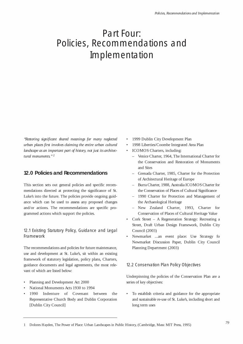
“Restoring significant shared meanings for many neglectedurban places first involves claiming the entire urban culturallandscape as an important part of history, not just its architec-tural monuments.” 1
12.0 Policies and Recommendations
This section sets out general policies and specific recom-mendations directed at protecting the significance of St.Luke’s into the future. The policies provide ongoing guid-ance which can be used to assess any proposed changesand/or actions. The recommendations are specific pro-grammed actions which support the policies.
12.1 Existing Statutory Policy, Guidance and LegalFramework
The recommendations and policies for future maintenance,use and development at St. Luke’s, sit within an existingframework of statutory legislation, policy plans, Charters,guidance documents and legal agreements, the most rele-vant of which are listed below:
• Planning and Development Act 2000• National Monuments Acts 1930 to 1994• 1990 Indenture of Covenant between the
Representative Church Body and Dublin Corporation[Dublin City Council]
• 1999 Dublin City Development Plan• 1998 Liberties/Coombe Integrated Area Plan• ICOMOS Charters, including:
– Venice Charter, 1964, The International Charter forthe Conservation and Restoration of Monumentsand Sites
– Grenada Charter, 1985, Charter for the Protectionof Architectural Heritage of Europe
– Burra Charter, 1988, Australia ICOMOS Charter forthe Conservation of Places of Cultural Significance
– 1990 Charter for Protection and Management ofthe Archaeological Heritage
– New Zealand Charter, 1993, Charter forConservation of Places of Cultural Heritage Value
• Cork Street – A Regeneration Strategy: Recreating aStreet, Draft Urban Design Framework, Dublin CityCouncil (2003)
• Newmarket ...an event place: Use Strategy foNewmarket Discussion Paper, Dublin City CouncilPlanning Department (2003)
12.2 Conservation Plan Policy Objectives
Underpinning the policies of the Conservation Plan are aseries of key objectives:
• To establish criteria and guidance for the appropriateand sustainable re-use of St. Luke’s, including short andlong term uses
Policies, Recommendations and Implementation
79
Part Four: Policies, Recommendations and
Implementation
1 Dolores Hayden, The Power of Place: Urban Landscapes in Public History, (Cambridge, Mass: MIT Press, 1995)

• The improved access to and presentation of St. Luke’s,the building and the site
• The protection and enhancement of the building andsite in a manner which retains their significance
• To improve connections between St. Luke’s and otherparts of the local area and the wider City Centre area
• To protect the sacred aspects of St. Luke’s as a burialground
• To protect and enhance the particular sense of placewhich pertains to St. Luke’s
12.3 Policies for the future ownership of St. Luke’s
Policy 1: That a Steering Group be established, whichincludes representatives of the key stakeholders, to overseethe implementation of the Conservation Plan policies andrecommendations.
Policy 2: The future use and ownership of St. Luke’s shouldbe guided by Dublin City Council and should reflect thepublic spirited intentions of the Representative ChurchBody when it transferred ownership of St. Luke’s in 1990to, as it was then, Dublin Corporation.
The ownership passed from the Church Of Ireland toDublin City Council in 1990 for a peppercorn fee.Therefore, in the spirit of the original intention of theChurch of Ireland when transferring ownership to the localauthority, public benefit should take pre-eminence in anydecision by Dublin City Council to lease or sell St. Luke’sand inform the details of any such change in its ownershipor use status.
12.4 Policies and Recommendations for the futureuse of St. Luke’s
Policy 2: That the future use of St. Luke’s should, in a man-ner which will retain the significance of the place, facilitatepublic access to the building and site, add to the social andcultural infrastructure of the area, into the future, and besocially, culturally and economically sustainable.
The consultation process involved discussion on variouspotential uses with a wide range of stakeholders and inter-ested groups and individuals. Arising from this and thestudy of the building, the site, the area and current policies
and objectives for the building and area, it was concludedthat St. Luke’s be restored to active use. However, the prin-ciple of a self sustaining use is critical to the future protec-tion of St. Luke’s. At the present time the availability ofpublic funding for either capital works or maintenance andprogramme funding cannot be assumed.
There are a number of potential uses which could complywith the above policy2.
A new Church use: A number of religious organisations haveexpressed interest in returning St. Luke’s to church use.Subject to the Church of Ireland and Dublin City Councilagreeing to amend the Covenant, this could be an appro-priate use and would accord with the conservation principlethat the original use is the best use for historic structures. Itis worth noting however, that the consultation processesindicated a generally shared aspiration that any future usewill be inclusive and integrated. As such, the use should beavailable to a broad public and not restricted to a selectcommunity. It is also worth noting that the physical mani-festations of contemporary church use vary from one reli-gious body to another, and may not necessarily fit neatlywithin the early 18th century structure of St. Luke’s.
Cultural/Educational/Tourism related:- International Language Resource Centre- Information Technology Library- Living Cultural Heritage Centre for the history of
labour and industry in the Liberties/ Coombe area.- Museum of Dublin Churches: Dublin is renowned for
its churches. Socially, culturally and architecturally thechurches have contributed greatly to the character ofDublin throughout the city’s history. At a time when thetraditional role and function of churches is changing, itwould be appropriate to record, interpret and presentthis rich story.
- Dublin Museum of Architectural History: hosting a dis-play of surviving architectural artefacts. This could becarried out in collaboration with the Dublin CivicTrust, who already retain a collection, and the IrishArchitectural Archive. It could be expanded to cover theplanning history of the City also with seminal plansexhibited.
- 6 day covered Market with potential for open air week-end markets within the grounds and, possibly quarterly,extension onto Newmarket
- Amenity/recreational use which would support adjacent
St. Luke’s Conservation Plan
802. While this Conservation Plan seeks to guide the future use of St. Luke’s, it does not make specific proposals for use. The uses includ-
ed in the list are for example only.

school facilities, while also being available for generalpublic use.
- Venue for training, practice, rehearsal, performance andexhibition
The future use of St. Luke’s could support any or a combi-nation of the above. Indeed, this list is not exhaustive andthere are many other uses which could comply with thepolicies contained in this Conservation Plan.
In conjunction with Policy 2 above, there are a number ofrecommendations which should be put into effect:
Recommendation A: It is acknowledged that it may takesome time before a suitable use for St. Luke’s will be found.In the interim it is recommended that, in conjunction withthe short term works, (listed further below), aimed at secur-ing the building and grounds and generally improving thepresentation of St. Luke’s, the building and/or site are putto early use. This may include temporary use for perform-ance, exhibition, art installations, etc., which would, inaddition to bringing the place back into use, raise generalpublic awareness and appreciation of, and stimulate interestin, St. Luke’s. These could be carried out as a programme of’events’ aimed at re-imagining and re-valuing St. Luke’s,possibly funded, or part funded, under schemes such as thePer Cent for Art Scheme. The current joint project betweenDublin City Council and the National College of Art andDesign (NCAD) which is focussing on the Cork Street area,could take St. Luke’s as a project site.
Recommendation B: In order to generate further interestand ideas for the future of St. Luke’s, it is recommendedthat an Ideas Competition is held. This should be open toall disciplines, indeed, multi-disciplinary teams should beencouraged. The Conservation Plan would be a startingpoint for developing a brief.
Recommendation C: Any proposals for long term useshould be supported by an appropriate feasibility study andbusiness plan which should, in addition to addressing com-pliance with the policies and recommendations in theConservation Plan, assess need and demand for the partic-ular use in the short, medium and long-term.
Policy 4: It is desirable that any new use should allow pub-lic access through the site, thus facilitating the connectionbetween The Coombe and the Cathedrals Precinct, toNewmarket and its urban hinterland.
Policy 5: Due to the extent of burials within the grounds ofSt. Luke’s it is preferable that any new use be accommodat-
ed within the footprint of the existing building. Any deci-sion to allow disturbance of in situ burials, as part of neces-sary excavation of ground to facilitate a new use, should beassessed against achieving the objectives for better access tothe site and/or the extent to which the new use would ful-fil the policies and recommendations of the ConservationPlan.
Current government and Dublin City Council policy isgenerally restrictive of development on graveyard sites.While the history of excavations to date indicate that exten-sive burials within the grounds, locations such as the line ofthe original and early entrance pathways, may be free ofburials.
Policy 6: That the future use of St. Luke’s will acknowledgethrough function and/or physical design, the rich history ofthe place and its relationship with the Liberties/Coombearea.
12.5 Policies and Recommendations for the Site
Policy 7: That the surviving grounds at St. Luke’s are pro-tected as a green space within the area, that they are notused as a car park and, that they are made accessible to thepublic.
To facilitate pedestrian access to the site, particularly fromthe new Coombe relief road, may involve some excavationof the earthen bank. The implication of policy 4 above sug-gests that any such excavation should be reviewed in rela-tion to its impact on burials and prevailing policy regardingdisturbance of burials.
Recommendation D: It is recommended that, in the shortterm, the dense growth around the site is carefully clearedand works to facilitate temporary access and use of St.Luke‘s are carried out. These should be carried out underguidance, so any significant planting, in situ graveslabs orother important fabric is not removed or damaged. Further,the various graveslabs within the site, which have beenremoved from their original locations and any loose archi-tectural fragments which are currently located in the under-growth should be carefully retrieved, recorded and storedfor future presentation. This material should be stored offany damp ground and covered in a manner to maintain aircirculation. See Recommendations F and P below regardingthe future storage/presentation of loose material of archi-tectural/historical significance and the requirement forappropriate expertise and advice when planning and imple-menting such works .
Policies, Recommendations and Implementation
81

Policy 8: That the sacred nature of the site as a burialground is respected in any future use of St. Luke’s, in par-ticular the grounds.
Recommendation E: It is recommended that a GraveyardMaintenance/Management Scheme is put in place in con-junction with the controlled grounds improvement/restora-tion works. This Scheme, which should follow the guide-lines issued by the DoEHLG and should include local his-tory, could record the surviving graveslabs and, followingconfirmation of their origin, advise on the most appropri-ate location for gravelsabs which have been moved fromtheir original location. The Scheme should also address bio-diversity aspects, in line with the Dublin City HeritagePlan, and include management schemes for flora and fauna.
Policy 9: Any new landscaping scheme for the site shouldacknowledge the historic character and functions of the siteand, equally, seek ways in which to improve the presenta-tion of St. Luke’s, in particular its northern aspect onto thenew road.
Through an imaginative landscaping scheme, it may bepossible to add a contemporary layering, without compro-mising the prevailing nature of the place. Considerationshould be given to the character of the site at night and theuse of lighting to augment character while addressing anypotential conflict arising with the requirements to protecthabitats as part of the recommendations to improve andprotect the biodiversity aspects of the site (refRecommendation E). Designs should be developed with aview to the varied experiences of being within the groundsand of viewing them from outside – from the new road,through the Newmarket gate and from the adjacent devel-opments which overlook St. Luke’s. Landscaping proposalsshould also avoid disturbance of burials.
Policy 10: That the surviving historic boundary walls to thesouth of the site and the Newmarket Gate are retained andrestored. That the surviving historic boundary walls to theeast of the site are substantially retained and, where partialremoval is carried out, it is done so in the context of facili-tating access to the site and improving connections with theadjacent area. That the Newmarket gateway be restored andreinstated as an entrance.
Recommendation F: The new boundary enclosure to thenorth should be welcoming in character, facilitating access(if avoidance of archaeological disturbance is possible), and
views of St. Luke’s. The western boundary wall, which is tobe reinstated, will, as a party wall to the new development,be solid. It runs very close to the west gable of the churchand forms a narrow path at the Newmarket entrance to thesite. It may be possible to integrate site lighting within thewall structure, in a subtle manner, in order to ‘lighten’ itspresence. The wall should either be addressed in a very sim-ple and restrained manner – lime rendered and decoratedusing a pigmented lime-wash, or considered as part of thecontemporary layer of landscape additions.
Policy 11: That the swifts, observed as welcome visitors tothe site, continue to be accommodated.
Recommendation G: Provision should be made for nestbox-es, fixed to the boundary walls, to encourage a colony ofswifts.
12.5 Policies and Recommendations for theBuilding and Architecture
Policy 12: In accordance with the statutory obligations per-taining to the Protected Structure status of St. Luke’s, thesurviving structure of the Church should be retained andrestored, including the external walls, window and dooropes, the ground floor nave, the east chancel and the crypts.
It is already acknowledged in the Conservation Plan that, asa Protected Structure, there is a statutory obligation onDublin City Council, as owner of St. Luke’s, to ensure thatthe structure, or any elements of it which contributes to itsparticular significance, are not in an endangered condition.
Recommendation H: To ensure the proper fulfilment of thestatutory obligations outlined above, it is recommendedthat an immediate programme of protection and repairworks should be carried out to conserve the fabric of thebuilding and halt deterioration and decay. This shouldinclude:
- Consolidation of the masonry walls to include: resettingof loose coping stones and any other necessary rebuild-ing or resetting of loose masonry; removal of cementrender on east gable; raking out of areas of dense cementpointing, and re-pointing of joints with a compatiblelime mortar3
- Removal of vegetation and organic growth, frommasonry both manually and with appropriate organicbiocide
St. Luke’s Conservation Plan
82 3. It is recommended that samples of the historic mortars are analysed and compatible mortars developed for the re-pointing works.

- Removal of surviving vegetation within the nave space,in particular the careful removal of roots within thefloor. The removal of these may involve localised tem-porary propping of the crypts and some removal andrebuilding of the brick vaulted structures.
- Repair of the hole in the nave floor- Repairs to east chancel decorative plasterwork. These
repairs will involve preparation of appropriate repairmethods and specialist repair. It is therefore recom-mended that a cocoon type protection be installed ini-tially to eliminate water and with provision for ventila-tion. In conjunction with this the roof to the east apseshould be covered for later repair.
- Removal of redundant services installation in the cryptsand corroded iron and steel which is embedded in thestructure and causing damage, including any corrodedglazing bars in the windows. Any historic gates or otherironwork of note, salvaged from the crypts, should beretained for repair and possible reinstatement.
Recommendation I: Allied to the above, a programme ofworks which would both improve the presentation of St.Luke’s and facilitate temporary use of the building shouldbe carried out in the short term. This would includeremoval of block infill from the window opes and provisionof more appropriate protective screens or new windows;replacement of steel doors and panels with new doors; pro-vision of a protective floor covering to the existing whichwill enable public access; removal of loose plaster from theinternal faces of the walls and, possible temporary servicesinstallation to facilitate use of, or animate the structure.Depending on the nature of any proposed use, it may benecessary to provide a roof covering. This could either becarried out as a temporary, reversible structure or, a morecarefully considered permanent roof. If no roof is being pro-vided, then the east chancel apse should be protected witha suitable cocoon covering. All works should be imple-mented in a manner which does not damage or compro-mise the fabric or integrity of the historic structure andensure compliance with relevant regulations.
Policy 13: The integrity of the historic single volume of thechurch should be considered in any adaptation and its rela-tionship with the classical east chancel set-piece. Any struc-tural installation to support new interventions, should beconsidered against any resultant negative impact on thecrypts, which should be minimised.
Policy 14: To avoid disturbance of burials, any new build-
ing to replace the vestry structure (which only partially sur-vives), should preferably fit within the footprint of the for-mer structures (ref. Policy 5).
Policy 15: The bellcote on the west gable is a distinctive fea-ture of St. Luke’s and should be retained. Considerationshould be given to reinstating the 1906 bell, if the ChurchOf Ireland were willing to return it. Alternatively, a new‘bell’ could be commissioned and installed, as a symbol ofconnection to the former use. The occasional use of this‘bell’ might add a distinctive new feature to the land-scape/soundscape and an echo of past histories and associa-tions.
Policy 16: The retention of the Victorian porch erectedagainst the original door on the north façade should bereviewed against established conservation principles ofretaining historic layers, and the architectural/aesthetic ben-efits of repairing and restoring this important original gran-ite doorway, by John Whinrey. Any decision to remove theVictorian porch should be weighed against the extent ofsurviving historic fabric from the granite door surround andconsequent level of restoration required to reinstate this fea-ture. Further, the possible future requirements for a pro-tected entry/porch as part of a new use, should be fullyassessed before any consideration to remove the existingporch is taken.
Policy 17: The complete and very rare surviving originalbuilding records for St. Luke’s – one of the most remarkablesurviving artefacts associated with the early 18th Centurychurch – should be published. The architectural signifi-cance of St. Luke’s is retained as much within this historicaldocumentation as it is within the surviving physical fabric.
Policy 18: An inventory based review of material, includingarchitectural elements, graveslabs, etc., belonging to St.Luke’s should be carried out to establish the extent of sur-viving material and its location and condition. Where thefindings of this study conflict with existing records, therecords should be appropriately amended.
Recommendation J: Surviving architectural fragments with-in the crypt space should be retrieved and recorded. Theseinclude the reredos4 of St. Peter’s Church and may includepart of the pre 1899 – 1900 reredos to St. Luke’s (theremaining pieces have been destroyed). Any surviving arte-facts of value from the building and the site, could formpart of a display of surviving loose architectural fabric,
Policies, Recommendations and Implementation
834. Reredos: An ornamental screen covering wall at the back of an altar.

which could be housed in an area in the crypt and availablefor research or general display, depending on the use of thebuilding and crypt. Alternatively, such fragments could becurated by an appropriate museum.
Policy 19: A building and site maintenance programmeshould be put in place to ensure the proper conservation ofthe site. This should include regular monitoring and inspec-tion and should form part of any lease or ownership agree-ments.
12.6 Policies and Recommendations for theUrban Setting and Context
Policy 20: New development taking place adjacent or prox-imate to St. Luke’s, should consider any historic connec-tions between sites. Opportunities to improve existing orfacilitate new links should be explored as should the facili-tation of access, vehicular (construction, maintenance andservice only) and pedestrian, to the site.
Recommendation K: Access to St. Luke’s to facilitate vehicle(construction, maintenance and service only) and pedestri-an users, from the site immediately adjacent to St. Luke’sshould be provided as part of any development schemehere. Consideration might be given to transfer a section ofthis vacant site to St. Luke’s to facilitate this access. Thiswould allow the re-development/restoration of St. Luke’s toproceed independent of the school site.
Policy 21: The impact of new development on St. Luke’sshould be reviewed with regard to its implications for thesignificance of St. Luke’s.
Recommendation L: Consideration should be given todensely planting the upper level courtyards and balconies ofthe site immediately west of St. Luke’s. This would providea foil to the large building content of this development andwould compliment the garden/park role of St. Luke’s.Historic maps show fine gardens within this site in the 19thcentury and such an approach might parallel this historicpattern.
Recommendation M: The Widows Alms House develop-ment site should reference the historic connection with St.Luke’s. While it is no longer possible to reflect this in thescheme design, a physical acknowledgement should beincorporated within the scheme.
Policy 22: Consideration should be given to how uses asso-ciated with new developments in the area consolidate andsupport the role and function of St. Luke’s.
Recommendation N: It is recommended that, once accessi-ble and its public presentation improved, St. Luke’s couldform part of a route/tourist trail of historic sites in theLiberties/Coombe area.
Policy 23: The physical presentation of the public realm ofSt. Luke’s Avenue, including tree planting, public lighting,ground surface treatments, signage, etc., should beimproved and upgraded with due regard to the immediatesetting around St. Luke’s.
Policy 24: In choosing names for new developments in thearea, consideration should be given to relevant historicaland cultural associations in accordance with the policies onstreet and place naming included in the Dublin CityDevelopment Plan 2005 - 2011.
12.7 Policies and Recommendations for theArchaeology of St. Luke’s
Policy 25: The disturbed human remains within the cryptsare to be exhumed and cremated/reburird in accordancewith the conditions of the Covenant. Prior to this there isto be a bone count of remains to determine minimumnumbers and a record of any pathology present. Thecoffined remains in the crypt are to be examined fully priorto their removal and cremation. This is in accordance withthe report prepared by Laureen Buckley, M.Sc., ConsultantOsteoarchaeologist, (ref Appendix E), and approved by theNational Museum, Department of Environment, Heritageand Local Government and Dublin City Council. Finalapproval should be sought from the Church of Ireland.
Recommendation O: The exhumation and cremation/reburial of the human remains in the crypts, should be putin hand in the short term. Under the terms of theCovenant, the crypt burials must be resolved before St.Luke’s can be put to any new use. Further, the existence ofthese remains poses serious health and safety issues for car-rying out any other work within the crypt space.
Recommendation P: It is recommended that any proposalfor improved access, modification of services, structuralalteration, landscaping, lighting, and other, involve a quali-fied archaeologist at planning and implementation stages.
St. Luke’s Conservation Plan
84

13.0 Implementation
The context for commissioning this Conservation Plan hasbeen the desire to find a suitable new use for St. Luke’s. Itwas hoped that the process of preparing the Plan mighthave elicited some potential users for the place. While therehave been a number of expressions of interest from prospec-tive users, as yet, there has been no concrete proposalsreceived. However, the process has stimulated considerabledebate and interest locally and, as development activitycontinues to grow within the area, interest in St. Luke’s iscertain to increase. It is appropriate therefore, that this Planhas been prepared in advance of any specific proposals andis not influenced by the particular demands of any use.
The Conservation Plan is not a statutory document.However, it will assist in the implementation of existingstatutory policy and law. The Conservation Plan is thebeginning of a long term process and its successful imple-mentation will depend on as wide acceptance and activesupport as possible. In preparing the Plan, consultation washeld with an extensive range of interest groups and individ-uals. Further consultation and dialogue will be necessary attimes during the life of the Plan.
13.1 Immediate/Short Term Actions
The Conservation Plan has made recommendations forshort term actions which should be implemented at an earlystage. These include
• Works to secure, protect and order the building andsite, including essential repair works to the building fab-ric in order to fulfil statutory obligations with regard tothe protected structure status of St. Luke’s
• Works to facilitate access to and through the site whichwill allow the opportunity to use the building and site
• Works to improve the presentation of the building andsite and thus, increase awareness of St. Luke’s
• Temporary and/or short term use of St. Luke’s includ-ing a programme of events/projects aimed at raisingappreciation of and awareness and interest in the site,
• Attending to the human remains within the crypts, fol-lowing the method agreed by all statutory parties.
• The Graveyard Management Scheme as set out inRecommendation E
It is recommended that a Steering Group be established,which includes representatives of the key stakeholders, tooversee the implementation of the Conservation Plan (refPolicy 1).
It is also recommended that an Ideas Competition for thefuture use of St. Luke’s is held. It could be run by a numberof agencies as a joint competition and might be successfulin generating further ideas and proposals for the future useof St. Luke’s. The constraints identified in the ConservationPlan should be included in the Brief.
To maintain the momentum and interest generated duringthe preparation of the Plan, it is recommended that theabove works and initiatives be implemented within 2004.
In order to achieve this programme, initial investment in St.Luke’s will be required. It is hoped that this investment canpump-prime a suitable and sustainable long term new usefor St. Luke’s. If such a use is not so readily forthcoming,then it may be necessary to allow short to medium termuses in the interim.
13.2 Review
The Conservation Plan will initiate and inform ongoingprocesses in the future life of St. Luke’s and may requirevariation at times along the way. It should be reviewed onan annual basis to assess the continued relevance of the poli-cies and to chart progress in implementing the recommen-dations.
Finally, the information contained in the Conservation Planincluding the Appendices, should from part of a site archiveand management document. Any new information – sur-vey, historical, archaeological, etc. – should be added to thefile as it becomes available. The file should be available as atool to those involved in the day to day management of thesite and when particular works are being planned.
Policies, Recommendations and Implementation
85

References & Sources
Primary Sources
Representative Church Body Library – St Luke’s ParishRecords:
Account Books (Churchwarden’s Accounts) Vol. I,1716-77.Combined Registers: Vol I, Baptism 1713-82,Marriages 1716-75, Burials 1716-81.Box of loose photographs.Box of loose papers c.1790-1976.Box file no. 105 of loose papers from the DiocesanRegistry 1728-1975.
Dublin City Archives (Gilbert Museum):William Monck Mason Collections vols. 1-9 (Dublin,1867).
National Gallery of IrelandIrish School, ink & wash on paper, St Luke’s, theCoombe, c.1818. (Reproduction of this work is bycourtesy of the National Gallery of Ireland).
Printed MapsJohn Speed, 1610Bernard de Gomme, 1673Charles Brooking, 1728John Rocque, 1756Ordnance Survey, 1847, 1903, 1939, 1966, 2002
Secondary Sources
Anonymous, “State and condition of the Roman CatholicChapels in Dublin, both secular and regular, A.D. 1749”,Egerton Manuscripts, British Library also TCDArchbishop’s Registry Box I, no. 18(10), reproduced inPatrick Fagan, The second city: portrait of Dublin 1700-1760 (Dublin, 1986), 127-32.
Nuala Burke, “A hidden church?”, Archivium HiberniciumXXII (1974), 81-92.
C.E.J. Caldicott, H. Gough, & J.-P. Pittion (eds), TheHuguenots and Ireland: anatomy of an emigration (DunLaoghaire, 1987).
Peter Costello, Dublin churches (Dublin, 1989).
John Crawford, Around the churches: the stories of thechurches in the St Patrick’s Cathedral group of parishes,Dublin (Dublin, 1988).
John Crawford, St Catherine’s parish Dublin 1840-1900:portrait of a Church of Ireland community (Dublin, 1996).L.M. Cullen, “The Irish economy in the eighteenth centu-ry” in L.M. Cullen (ed.) The formation of the Irish economy(Cork, 1969), 9-21.
Virginia G. Davis, “Relations between the abbey of StThomas the Martyr and the municipality of Dublin”,Dublin Historical Record 40, no. 2, (1987), 57-65.
Dublin City Council, Planning Dept., “Newmarket…anevent place. Use strategy for Newmarket discussion paper”(Dublin 2003)
The Dublin Builder, V (Feb 15th, 1863), 33.
Dublin Corporation, “Liberties/Coombe Integrated AreaPlan 1998” (Dublin 1998)
Cathal Duddy, “The role of St Thomas’s abbey in the earlydevelopment of Dublin’s western suburb” in Seán Duffy(ed.) Medieval Dublin IV, Proceedings of the Friends ofMedieval Dublin Symposium 2002 (Dublin, 2003), 79-97.
A.L. Elliot, “The abbey of St Thomas the Martyr, nearDublin” first published 1892, reprinted in Howard Clarke(ed.) Medieval Dublin: the living city (Dublin, 1990), 62-76.
Paul Ferguson (ed.), The A to Z of Georgian Dublin: JohnRocque’s maps of the city in 1756 and the county in 1760(Lympne Castle, Kent, 1998).
Ann Dominica FitzGerald O.P., “Down the old Poddle” inElgie Gillespie (ed.), The Liberties of Dublin (Dublin,1973), 24-33.
J.T. Gilbert, Calender of the ancient records of Dublin volvi, (Dublin, 1896).
Jean Gimpell, The medieval machine: the industrial revolu-tion of the middle ages, 2nd edition (London, 1988).
James Godkin, Ireland and her churches (London, 1867).
Tommy Graham, “Whitelaw’s 1798 census of Dublin”,History Ireland, II no. 3 (Autumn, 1994).
Aubrey Gwynn, “The early history of St Thomas’ Abbey,Dublin”, Journal of the Royal Society of Antiquaries 84(1954), 1-35.
St. Luke’s Conservation Plan
86
Aubrey Gwynn & R. Neville Hadcock, Medieval religioushouses: Ireland reprint (Dublin, 1988).
“Huguenot graves in Dublin” The Irish Times September4th, 1915.
Vivien Igoe, Dublin burial grounds and graveyards (Dublin,2001).
J.J. Digges La Touche (ed.), Registers of the French con-formed churches of St Patrick and St Mary Dublin (Dublin,1893).
Grace Lawless Lee, The Huguenot settlements in Ireland(London, 1936).
Samuel Lewis, A topographical dictionary of Ireland(London, 1837).
Rolf Loeber, A biographical dictionary of architects inIreland, 1600-1720 (London, 1981).
J.B. Malone, “Maps and the Liberties”, in Elgie Gillespie(ed.), The Liberties of Dublin (Dublin, 1973), 34-9.
Niall McCullough, Dublin, an urban history (Dublin,1989).
Ruth McManus, Dublin, 1910-1940 Shaping the City andSuburbs (Dublin 2002)
Edward McParland, Public architecture in Ireland 1680-1760 (New Haven and London, 2001).
William Monck Mason, The history and antiquities of thecollegiate and cathedral church of St Patrick, near Dublin,from its foundation in 1190, to the year 1819 (Dublin,1819).
Peter Pearson, The heart of Dublin: resurgence of an historiccity (Dublin, 2000)
Myles V. Ronan, “The Poddle River and its branches”,Journal of the Royal Society of Antiquaries 56 (1926), 39-46.
Kenneth Severens, “A new perspective on Georgian build-ing practice: the re-building of St Werburgh’s church,Dublin (1754-59)”, Irish Georgian Society Bulletin XXXIV
(1992-3), 3-16.
Edel Sheridan, “Designing the capital city: Dublin c.1660-
1810” in Joseph Brady & A Simms (eds) Dublin throughspace and time (c.900-1900) (Dublin, 2001), 66-135.
Anngret Simms, “Origins and early growth” in JosephBrady & A Simms (eds) Dublin through space and time(c.900-1900) (Dublin, 2001), 15-65.
Linzi Simpson, “Historical background to the PatrickStreet excavation” in Claire Walsh (ed.) Archaeologicalexcavations at Patrick, Nicholas & Winetavern Streets,Dublin (Dingle, 1997), 17-33.
The statutes at large, passed in the parliaments held inIreland : from the third year of Edward the Second, A.D.1310 to the twenty sixth year of George the Third, A.D.1786 inclusive (Dublin, 1786).
Clair L. Sweeney, The rivers of Dublin (Dublin, 1991).
Claire Walsh, “Archaeological excavations at the abbey ofSt Thomas the Martyr, Dublin” in Seán Duffy (ed.)Medieval Dublin I, Proceedings of the Friends of MedievalDublin Symposium 1999 (Dublin, 2000), 185-202.
Peter Walsh, “Dutch Billys in the Liberties” in ElgieGillespie (ed.), The Liberties of Dublin (Dublin, 1973),58-75.
J. Warburton, J. Whitelaw & Robert Walsh, History of thecity of Dublin vol. I (London, 1818).
H.A. Wheeler & M.J. Craig, The Dublin city churches ofthe Church of Ireland (Dublin, 1948).
Margaret Whinney, Wren (London, 1971).
G.N. Wright, An historical guide to the city of Dublin 2ndedition (London, 1825).
Nigel Yates, Buildings, faith and worship: the liturgicalarrangement of Anglican churches 1600-1900 (Oxford,1991).
Unpublished ThesesJohn Crawford, “Churches, people and pastors: theChurch of Ireland in Victorian Dublin, 1833-1901”(Unpublished PhD thesis, Maynooth Department ofModern History, 2003).
Virginia G. Davis, “The abbey of St Thomas the Martyrnear Dublin, 1176-1400”, (Unpublished BA thesis,Dublin University Department of History, 1980).
References and sources
87

Other Unpublished ReportsSiobhan Deery & Dr. Annaba Kilfeather (for MargaretGowen & Co. Ltd.), ‘Archaeolgical Appraisal, Ardee Streetand Cork Street, Dublin 8’ (Unpublished report for BowStreet Construction Ltd., July 4th 2001).
Stephen Doyle (for Archaeological Development ServicesLtd.), ‘Archaeological Desktop Study of Site at YMCA,Aungier St., Dublin 2’ (Unpublished report for Ian DarbyPartnerships, March 2001).
Stephen Doyle (for Archaeological Development ServicesLtd.), ‘Report on a Survey of a Stone Wall at the rear ofthe YMCA, Aungier St., Dublin 2’ (Unpublished reportfor Ian Darby Partnerships, November 2002).
Dublin City Council, City Architect’s Division, PlanningDept., ‘Cork Street – A Regeneration Strategy, Recreatinga Street’ (Draft Urban Design Framework, April 2003).
Dublin Corporation, Planning Dept., ‘CorkStreet/Coombe Relief Route: Environmental ImpactStudy’ (1994)
Dublin Corporation, Planning Dept., ‘CorkStreet/Coombe Relief Route: Environmental ImpactStudy’ (1998)
Ruth Elliot (for Archaeological Development ServicesLtd.), ‘Archaeological Test Excavation at St. Peter’sChurchyard, Peter Row, Dublin 2’ (Unpublished reportfor YMCA, December 2002).
Andrew Halpin, ‘Report for Environmental Impact Studyon the Archaeological Implications of the ProposedCoombe/Ardee St./Cork St./Dolphin’s Barn St. ReliefRoad’ (July 1993)
Alan Hayden, ‘Preliminary Report on the Archaeology, theCoombe By-pass and Cork Street RealignmentRoadworks, Dublin. (Date?)
Jackie Jordan (for Margaret Gowen & Co Ltd), ‘Historicalbackground and architectural assessment St Luke’s ChurchThe Coombe Dublin 8’ (Unpublished archival report forDr Ruth Johnson, Dublin City Archaeolgoist, DublinCity Council, 20th March 2003).
Jackie Jordan (for Margaret Gowen & Co. Ltd),‘Photographic Survey and Architectural Assessment, TheWidow’s House, The Coombe, Dublin 8’ (Unpublishedreport on behalf of Group Design Architects for Nicki
Matthews, Dublin City Conservation Officer, 7th May2003).
MRUP II, ‘Urban Design Framework Plan, CorkStreet/Coombe Corridor, Dublin 8’ (Unpublished studyby students in year 2 of the Masters of Regional andUrban Planning, UCD, October 2002).
Murray O’Laoire Architects, ‘Coombe-Newmarket UrbanDesign Framework’ (Unpublished report for DublinCorporation’s Architect’s Dept. and Liberties/Coombe IAPteam, December 2000).
Tourism Development International, ‘Tourism ScopingStudy, Liberties/Coombe & Kilmainham/Inchicore (Draft)’(Unpublished Draft Report for Dublin City Council).
Claire Walsh, ‘Archaeological test excavation of a site atHoly Faith School, Coombe Relief Road, Dublin 8’(December 2002).
Peter Walsh, “St Luke’s Church, the Coombe, Dublin:draft notes on its architectural and general history”(Unpublished archival report for a conservation plan for StLuke’s the Coombe, Dublin City Council, 2003).
Andrew Halpin, ‘Report for Environmental Impact Studyon the Archaeological Implications of the ProposedCoombe/Ardee St./Cork St./Dolphin’s Barn St. ReliefRoad’ (July 1993)
Alan Hayden, ‘Preliminary Report on the Archaeology, theCoombe By-pass and Cork Street RealignmentRoadworks, Dublin. (Date?)
Jackie Jordan (for Margaret Gowen & Co Ltd), ‘Historicalbackground and architectural assessment St Luke’s ChurchThe Coombe Dublin 8’ (Unpublished archival report forDr Ruth Johnson, Dublin City Archaeolgoist, DublinCity Council, 20th March 2003).
Jackie Jordan (for Margaret Gowen & Co. Ltd),‘Photographic Survey and Architectural Assessment, TheWidow’s House, The Coombe, Dublin 8’ (Unpublishedreport on behalf of Group Design Architects for NickiMatthews, Dublin City Conservation Officer, 7th May2003).
MRUP II, ‘Urban Design Framework Plan, CorkStreet/Coombe Corridor, Dublin 8’ (Unpublished studyby students in year 2 of the Masters of Regional andUrban Planning, UCD, October 2002).
St. Luke’s Conservation Plan
88

Murray O’Laoire Architects, ‘Coombe-Newmarket UrbanDesign Framework’ (Unpublished report for DublinCorporation’s Architect’s Dept. and Liberties/Coombe IAPteam, December 2000).
Tourism Development International, ‘Tourism ScopingStudy, Liberties/Coombe & Kilmainham/Inchicore(Draft)’ (Unpublished Draft Report for Dublin CityCouncil).
Claire Walsh, ‘Archaeological test excavation of a site atHoly Faith School, Coombe Relief Road, Dublin 8’(December 2002).
Peter Walsh, “St Luke’s Church, the Coombe, Dublin:draft notes on its architectural and general history”(Unpublished archival report for a conservation plan for StLuke’s the Coombe, Dublin City Council, 2003).
References and sources
89

St. Luke’s Conservation Plan
90

Executive Summary
91

St. Luke’s Conservation Plan
92

Executive Summary
93

St. Luke’s Conservation Plan
94