Embed Size (px)
Citation preview

Statusseminar Meeresforschung mit FS SONNE14. – 15. Februar 2017 in Oldenburg
Tagungsband
114
SO232 – The Mozambique Ridge: a document of
massive multistage magmatism
M . D . Fischer1, G . Uenzelmann-Neben1, G . Jacques2, R . Werner2
1 Alfred-Wegener-Institut Helmholtz-Zentrum für Polar- und Meeresforschung, Bremerhaven
2 GEOMAR Helmholtz-Zentrum für Ozeanforschung, Kiel
The Mozambique Ridge, a prominent basement high in the southwestern Indian Ocean, consists of four major geomorphological segments associated with numerous phases of volcanic activity in the Lower Cretaceous (König and Jokat, 2010) . The nature and origin of the Mozambique Ridge have been intensely debated with one hypothesis suggesting a Large Igneous Province origin (Gohl et al ., 2011) .
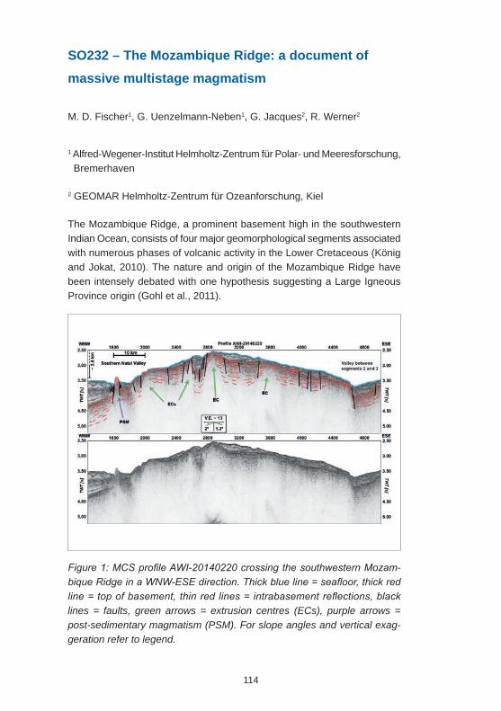
Figure 1: MCS profile AWI-20140220 crossing the southwestern Mozam-bique Ridge in a WNW-ESE direction. Thick blue line = seafloor, thick red line = top of basement, thin red lines = intrabasement reflections, black lines = faults, green arrows = extrusion centres (ECs), purple arrows = post-sedimentary magmatism (PSM). For slope angles and vertical exag-geration refer to legend.
115
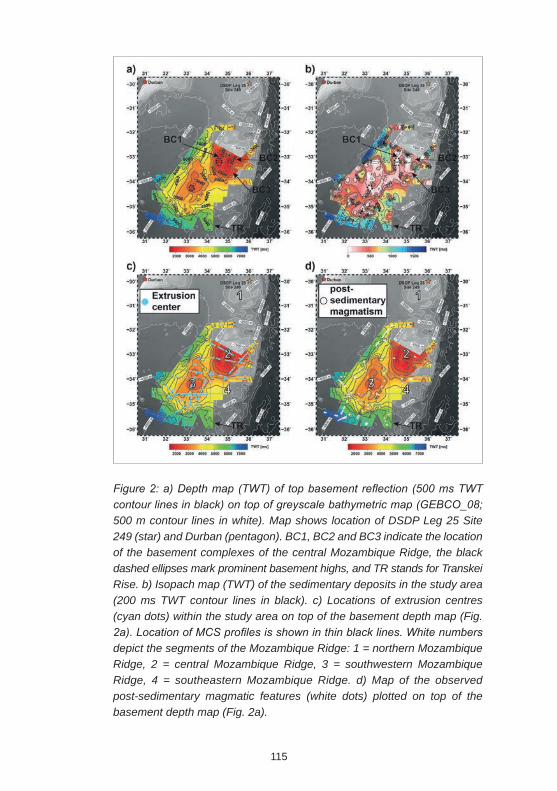
Figure 2: a) Depth map (TWT) of top basement reflection (500 ms TWT contour lines in black) on top of greyscale bathymetric map (GEBCO_08; 500 m contour lines in white). Map shows location of DSDP Leg 25 Site 249 (star) and Durban (pentagon). BC1, BC2 and BC3 indicate the location of the basement complexes of the central Mozambique Ridge, the black dashed ellipses mark prominent basement highs, and TR stands for Transkei Rise. b) Isopach map (TWT) of the sedimentary deposits in the study area (200 ms TWT contour lines in black). c) Locations of extrusion centres (cyan dots) within the study area on top of the basement depth map (Fig. 2a). Location of MCS profiles is shown in thin black lines. White numbers depict the segments of the Mozambique Ridge: 1 = northern Mozambique Ridge, 2 = central Mozambique Ridge, 3 = southwestern Mozambique Ridge, 4 = southeastern Mozambique Ridge. d) Map of the observed post-sedimentary magmatic features (white dots) plotted on top of the basement depth map (Fig. 2a).
116
High-resolution seismic reflection data gathered during Sonne expedition SO232 reveal a large number of extrusion centres with a random distribution throughout the southern Mozambique Ridge and the nearby Transkei Rise . Intrabasement reflections emerge from the extrusion centres and are interpreted to represent massive lava flow sequences. Such lava flow sequences are characteristic for eruptions leading to the formation of continental and oceanic flood basalt provinces, hence supporting a Large Igneous Province origin of the Mozambique Ridge (Uenzelmann-Neben et al ., 1999; Sager et al ., 2013; Pietsch and Uenzelmann-Neben, 2015) . We observe evidence for widespread post-sedimentary magmatic activity that we suggest to correlate with a Neogene southward propagation of the East African Rift System .
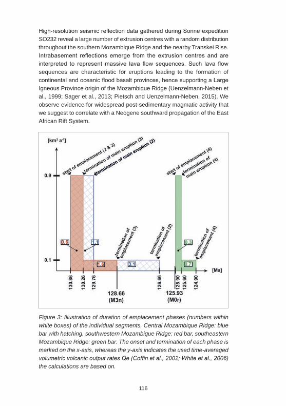
Figure 3: Illustration of duration of emplacement phases (numbers within white boxes) of the individual segments. Central Mozambique Ridge: blue bar with hatching, southwestern Mozambique Ridge: red bar, southeastern Mozambique Ridge: green bar. The onset and termination of each phase is marked on the x-axis, whereas the y-axis indicates the used time-averaged volumetric volcanic output rates Qe (Coffin et al., 2002; White et al., 2006) the calculations are based on.
117
Based on our volumetric analysis of the southern Mozambique Ridge we infer a rapid sequential emplacement between ~131 and ~125 Ma, which is similar to the short formation periods of other Large Igneous Provinces like the Agulhas Plateau .
References
M.F. Coffin, M.S. Pringle, R.A. Duncan, T.P. Gladczenko, M. Storey, R.D. Müller, L .A . Gahagan, 2002 . Kerguelen Hotspot Magma Output since 130 Ma . Journal of Petrology 43, 1121-1137,
K . Gohl, G . Uenzelmann-Neben, N . Grobys, 2011 . Growth and Dispersal of a Southeast African Large Igneous Province . South African Journal of Geology 114, 379-386, 10.2113/gssajg.114.3-4.379.
M . König, W . Jokat, 2010 . Advanced insights into magmatism and volcanism of the Mozambique Ridge and Mozambique Basin in the view of new potential field data. Geophysical Journal International 180, 158-180, 10.1111/j.1365-246X.2009.04433.x.
R . Pietsch, G . Uenzelmann-Neben, 2015 . The Manihiki Plateau—A multistage volcanic emplacement history . Geochemistry, Geophysics, Geosystems 16, 2480-2498, 10.1002/2015GC005852.
W .W . Sager, J . Zhang, J . Korenaga, T . Sano, A .A .P . Koppers, M . Widdowson, J .J . Mahoney, 2013 . An immense shield volcano within the Shatsky Rise oceanic plateau, northwest Pacific Ocean. Nature Geoscience 6, 976-981, 10.1038/ngeo1934.
G . Uenzelmann-Neben, K . Gohl, A . Ehrhardt, M . Seargent, 1999 . Agulhas Plateau, SW Indian Ocean: New Evidence for Excessive Volcanism . Geophysical Research Letters 26, 1941-1944,
S .M . White, J .A . Crisp, F .J . Spera, 2006 . Long-term volumetric eruption rates and magma budgets . Geochemistry, Geophysics, Geosystems 7, Q03010, 10.1029/2005GC001002.