Embed Size (px)
Citation preview

Study of integrated water resources management in the north of Tunisia – Irrigation projects Outline of semi-final Report of TS-P7, TS-P11 and TS-P13 Projects Page iii de vii
JBIC / SCET-Tunisie Bus : 04-55 version B May 2005
SUMMARY
III - ANALYSIS OF THE CONSTRAINTS TO PERIMETERS DEVELOPMENT III-1
III.1 - MANAGEMENT, EDUCATION AND COORDINATION CONSTRAINTS ............................................................III-1 III.1.1 - Beneficiaries constraints ................................................................................................................... III-1 III.1.2 - Constraints to financing the development ......................................................................................... III-2 III.1.3 - The lack of coordination between the different participants ............................................................. III-3 III.1.4 - Production support structures constraints ........................................................................................ III-3 III.1.5 - Popularization and research structures constraints.......................................................................... III-4
III.2 - LAND CONSTRAINTS ................................................................................................................................III-4 III.2.1 - Constraints of the structures responsible for land improvement ....................................................... III-4 III.2.2 - The validity of the division proposed by the AFA after regrouping................................................. III-11 III.2.3 - Absence of land registration............................................................................................................ III-11 III.2.4 - Rural short term tenancy agreements.............................................................................................. III-11
III.3 - TECHNICAL CONSTRAINTS.....................................................................................................................III-12 III.3.1 - Constraints of the mobilized physical potentialities ........................................................................ III-12 III.3.2 - Constraints on the level of the hydraulic equipments for drinking water supply ............................ III-34 III.3.3 - Constraints on the level of the hydraulic equipments for cultivations irrigation ............................ III-34 III.3.4 - Constraints of the arranged fields drainage.................................................................................... III-46
III.4 - RECOMMENDATIONS .............................................................................................................................III-52 III.4.1 - Lessons to be drawn from these constraints to the good development ............................................ III-52 III.4.2 - The redefinition of the Projects objectives to ensure a good mid-term evaluation : ....................... III-56 III.4.3 - Recommended directions for the Action Plan aiming to a good development................................. III-93
LIST OF MAPS
Map n°III-1 : Agricultural lands values provided to the AFA for TS-P7 Project two perimeters .......... III-5 Map n°III-2 : Agricultural lands values provided to the AFA for Goubellat perimeter.......................... III-6 Map n°III-3 : Agricultural lands values provided to the AFA for TS-P13 Project perimeters ............... III-7 Map n°III-4 : Compartmental after AFA regrouping for the two TS-P7 Project perimeters ................. III-8 Map n°III-5 : Compartmental after AFA regrouping for Goubellat perimeter ...................................... III-9 Map n°III-6 : Compartmental after AFA regrouping for the two TS-P13 Project perimeters ............. III-10 Map n°III-7 : MNT of the two TS-P7 Project perimeters ..................................................................... III-13 Map n°III-8 : Topographical constraints in the two TS-P7 Project perimeters..................................... III-14 Map n°III-9 : Pedological cover of the two TS-P7 Project perimeters ................................................. III-17 Map n°III-10 : Pedological constraints of Nefza perimeter .................................................................. III-18 Map n°III-11 : Pedological constraints of Sejnane perimeter ............................................................... III-19 Map n°III-12 : Physical potentialities with irrigation before installation in Nefza ............................... III-20 Map n°III-13 : Physical potentialities with irrigation before installation in Sejnane ............................ III-21 Map n°III-14 : Physical potentialities with irrigation after installation in Nefza .................................. III-22 Map n°III-15 : Physical potentialities with irrigation after installation in Sejnane............................... III-23 Map n°III-16 : MNT of Goubellat perimeter ........................................................................................ III-24 Map n°III-17 : Topographical constraints in Goubellat perimeter ........................................................ III-27 Map n°III-18 : Pedological cover of Goubellat perimeter..................................................................... III-28

Study of integrated water resources management in the north of Tunisia – Irrigation projects Outline of semi-final Report of TS-P7, TS-P11 and TS-P13 Projects Page iv de vii
JBIC / SCET-Tunisie Bus : 04-55 version B May 2005
Map n°III-19 : Pedological constraints of Goubellat perimeter ............................................................ III-29 Map n°III-20 : Physical potentialities with irrigation before installation in Goubellat perimeter......... III-30 Map n°III-21 : Physical potentialities with irrigation after installation in Goubellat perimeter ........... III-31 Map n°III-22 : MNT of TS-P13 Project two perimeter......................................................................... III-32 Map n°III-23 : Topographical constraints in the two TS-P13 Project perimeters................................. III-35 Map n°III-24 : Pedological cover of the two TS-P13 Project perimeters ............................................. III-36 Map n°III-25 : Pedological constraints of Fernana perimeter ............................................................... III-37 Map n°III-26 : Pedological constraints of Hammam Bourguiba perimeter .......................................... III-38 Map n°III-27 : Physical potentialities with irrigation before installation in Fernana perimeter ........... III-39 Map n°III-28 : Physical potentialities with irrigation before installation in Hammam Bourguiba ....... III-40 Map n°III-29 : Physical potentialities with irrigation after installation in Fernana............................... III-41 Map n°III-30 : Physical potentialities with irrigation after installation in Hammam Bourguiba perimeter
....................................................................................................................................................... III-42 Map n°III-31 : Hydraulic network of Nefza perimeter ......................................................................... III-43 Map n°III-32 : Hydraulic network of Sejnane perimeter ...................................................................... III-44 Map n°III-33 : Goubellat perimeter hydraulic networks....................................................................... III-47 Map n°III-34 : Hydraulic networks of the two TS-P13 perimeters....................................................... III-48 Map n°III-35 : Hammam Bourguiba perimeter hydraulic networks ..................................................... III-49 Map n°III-36 : RFU of TS-P7 Project two perimeter grounds.............................................................. III-50 Map n°III-37 : RFU of Goubellat perimeter grounds............................................................................ III-53 Map n°III-38 : RFU of TS-P13 Project two perimeters grounds .......................................................... III-54 Map n°III-39 : Optimum grounds occupation of TS-P7 Project two perimeters .................................. III-62 Map n° III-40 : Optimum grounds occupation of Goubellat perimeter................................................. III-63 Map n°III-41 : Optimum grounds occupation in TS-P13 Project perimeters........................................ III-81 Map n°III-42 : Distribution of correcting factors of theoretical water requirements in Nefza perimeter
....................................................................................................................................................... III-82 Map n°III-43 : Distribution of correcting factors of theoretical water requirements in Sejnane perimeter
....................................................................................................................................................... III-85 Map n°III-44 : Distribution of the correcting factors of theoretical water requirements in Goubellat
perimeter........................................................................................................................................ III-86 Map n°III-45 : Distribution of the correcting factors of theoretical water requirements in Fernana perimeter
....................................................................................................................................................... III-89 Map n°III-46 : Distribution of the correcting factors of theoretical water requirements Hammam Bourguiba
perimeter........................................................................................................................................ III-90

Study of integrated water resources management in the north of Tunisia – Irrigation projects Semi-final Report of TS-P7, TS-P11 and TS-P13 Projects Page III-1 de 95
JBIC / SCET-Tunisie Bus : 04-55 version B May 2005
III - Analysis of the constraints to perimeters development It is now necessary to evaluate the capacity of irrigation public services to ensure water pumping out and adduction systems functioning and maintenance ; the capacity of the GIC to ensure irrigation water distribution systems operation and maintenance ; the capacity of popularization public services to train those farmers in the irrigated agriculture field ; and finally, the will and the capacity of these farmers to produce, to store, to sell or transform their new agricultural irrigated productions. It should be checked if the three projects general conditions will be able to make the will expressed by all the recipients a reality through a capacity to produce, to store, to market their new irrigated agricultural productions, either in their natural state or after transformation It is obvious that the farmers capacity will first depend on the quality of the installations made avaible to them. But it will also depend on the capacity of:
• the irrigation public services to ensure pumping out and adduction systems functioning and maintenance ;
• the recipients who have to be GIC members and ensuring irrigation water supplying systems functioning and maintenance;
• the popularization public services to ensure these farmers training in irrigated agriculture; • the Tunisian system of credits intended for agriculture to finance :
o in medium or long term all the equipment, the collecting and transportation materials,and the transformation and storage units ;
o in the short term all the new factors necessary to the good control of the irrigated cultivations and the integrated farming.
All the met constraints will be evaluated for the three Projects.
III.1 - Management, education and coordination constraints
III.1.1 - Beneficiaries constraints
a) Exploitation heads age and education standard As everywhere in Tunisia, the exploitation heads have a quite high average age because they don’t accept easily to retire in order to keep their financial independence towards their children, as well as a certain social position, and in order to not be ennoyed. Goubellat perimeter is favored, however, by the presence of 15 SMVDA run by relatively young and very dynamic technical persons, and 21 young and motivated agricultural technician.
b) Competence standard in irrigated agriculture The 5 CTV have made since 3 years all the compatible efforts with their weak material and budget allocations in order to meet or even anticipate the beneficiaries requests by organizing information days, demonstration plots and trainings in CFPA. But through lack of money, some gaps remain and it’s certain that the irrigated cultivations objective outputs will be realized only after some practice years once the perimeter is set in water.

Study of integrated water resources management in the north of Tunisia – Irrigation projects Semi-final Report of TS-P7, TS-P11 and TS-P13 Projects Page III-2 de 95
JBIC / SCET-Tunisie Bus : 04-55 version B May 2005
c) The will to work jointly The will to work jointly exists but in a voluntary and informal way among the 2 perimeter farmers. In the 2 cases, it depends on common interests, neighborhood and blood relationship. This will is not, however, shown on formalities, especially when the membership to the GIC is obligatory and it’s a brand-new organization for people. In fact, this will should be reinforced by sensitization, supervision and technical support to guarantee reaching the expected results.
III.1.2 - Constraints to financing the development
a) Beneficiaries weak available funds The beneficiaries actual categorization presented in Chapter 2 shows that the situation is relatively critical in Nefza, Sejnane, Fernana and Hamam Bourguiba perimeters. More than the half of the small exploitations (small farms) will remain non-viable and will not always be eligible for the BNA financing even after the setting in water.
b) Associations and financing ONG weak available funds In contrary of Sejnane, Goubellat, Fernana and Hamam Bourguiba delegations where no local ONG were constituted, “Jbel Labiedh” ONG is active in Nefza delegation. In order to make this ONG responsible for supporting farmers concerned by irrigation development, talks are actually being made on the local level. The situation would have been developed in Fernana delegation which is object to a presidential pilot Project financing the PACFS, and where the local authorities and PACFS Project Unit seek already to encourage an ONG establishment. It should be emphasized that authorized financings for this financing organization type are limited to a maximum of 3.000 TD. So, they can’t secure the financing of plot equipments for irrigation water saving, but only for small exploitations (small farms) having less than 1 ha of SAU.
c) Credit beneficiaries selection criteria by the concerned organization In addition to the general case of the bad payers having an unlisted number to the BNA, 6 situation prevent the perimeters future irrigators to receive investment loans:
• for owners, the too small exploitation size or land registration absence. • For state-owned lands tenants in Nefza and Goubellat, the too small plot size, the absence of
tenancy agreement or its limited duration at only 3 years. • For the recipients of state-owned lands(habous) in Goubellat, the non-issue of a title deed by
competent authorities. With credit associations advent, the selection criteria would be less restrictive through a payment reassuring system like the one established within the framework of the PACFS financing project.

Study of integrated water resources management in the north of Tunisia – Irrigation projects Semi-final Report of TS-P7, TS-P11 and TS-P13 Projects Page III-3 de 95
JBIC / SCET-Tunisie Bus : 04-55 version B May 2005
III.1.3 - The lack of coordination between the different participants
a) A weak realization rate of attendant measures for the development The realization of the attendant measures for the development was lacking the projected budget within the framework of the project financing by the JBIC for these actions. It was led in function of the available budgets on the level of Beja CRDA.
a.1) a.1) Training/popularization programs for irrigated agriculture techniques Considering the recent contract between Beja CRDA and design office BICHE, the training of the farmers is just starting in Nefza and Goubellat perimeters. In this plot, it is envisaged to initiate the new irrigators to the techniques of water saving and to the various considered crops. For the other perimeters no specific action has been started, yet.
a.2) Windbreaks plantation programs
The realization of the attendant measures for the development was lacking the projected budget within the framework of the project financing by the JBIC for these actions. It was led in function of the available budgets on the level of the three CRDA. Generally, the Project Units received support from Forests District to start the external and secondary plantations on the perimeter boundaries, whereas the hedges between plots were not seriously started by the recipients.
b) Local structures made reponsible for providing financing to new irrigators
b.1) Local structures will of intervention to finance the farm and irrigation equipment and the livestock
Considering the limited capacities of “Jbel Labiedh” ONG in Nefza delegation and of the absence of ONG in the other four delegations, the three CRDA directed the farmers to make grouped purchases in order to solve the difficulties related to self-financing.
b.2) Local structures will of intervention to finance the future expenses of countryside in irrigated The three BNA agencies are completely inclined to grant countryside appropriations. The only condition is that the applicant should respect his engagements towards the Bank.
III.1.4 - Production support structures constraints For these 2 perimeters installed in quite marginal zones, there is a risk to have some lacks on the level of the pre-production: supplyers of agricultural inputs, supplyers of agricultural equipment, these equipment maintenance workshops. These 2 perimeters are quite far from the country s’ consumption large zones. So, the beneficiaries could find at the starting up difficulties to sell their truck, fruit and animal productions. The project did not ,however, envisaged any encouragement for financing the construction of transformation or storage units for the irrigated productions, whereas actually there is only one private dairy in Sejnane, which is getting on again after several years of break in all activities.
Study of integrated water resources management in the north of Tunisia – Irrigation projects Semi-final Report of TS-P7, TS-P11 and TS-P13 Projects Page III-4 de 95
JBIC / SCET-Tunisie Bus : 04-55 version B May 2005
III.1.5 - Popularization and research structures constraints
a) Weakness of the human resources responsible for supporting the agriculture in mountainous regions of the North-west
Since the constitution of the ODESYPANO, one can witness in all the North-west region that there has been a tasks sharing with the CRDA. This latter has emphasized its activities in the irrigated zones and the cereal plains of Mejerdah river valley while the first has dealt with the mountainous zones.
b) Agronomic research structures weak available funds The tunisian agronomic research (INRAT, INRGREF ) is highly penalized by the few human, material and financial means at its disposal.
c) Popularization structures weak available funds The project did not included any popularization action in the budget. All what have been done was on Bizerte and Beja CRDA, or the AVFA, general budgets.
III.2 - Land constraints
III.2.1 - Constraints of the structures responsible for land improvement
a) The absence of a true tunisian policy of land reform So that an agricultural land improvement proceeds in accordance with land reform laws in the irrigated public perimeters, the services requested from the AFA are limited to a regrouping carried out in three successive phases :
• constitution of the perimeter creation file, • development of the regrouping project, • Approval of the regrouping project.
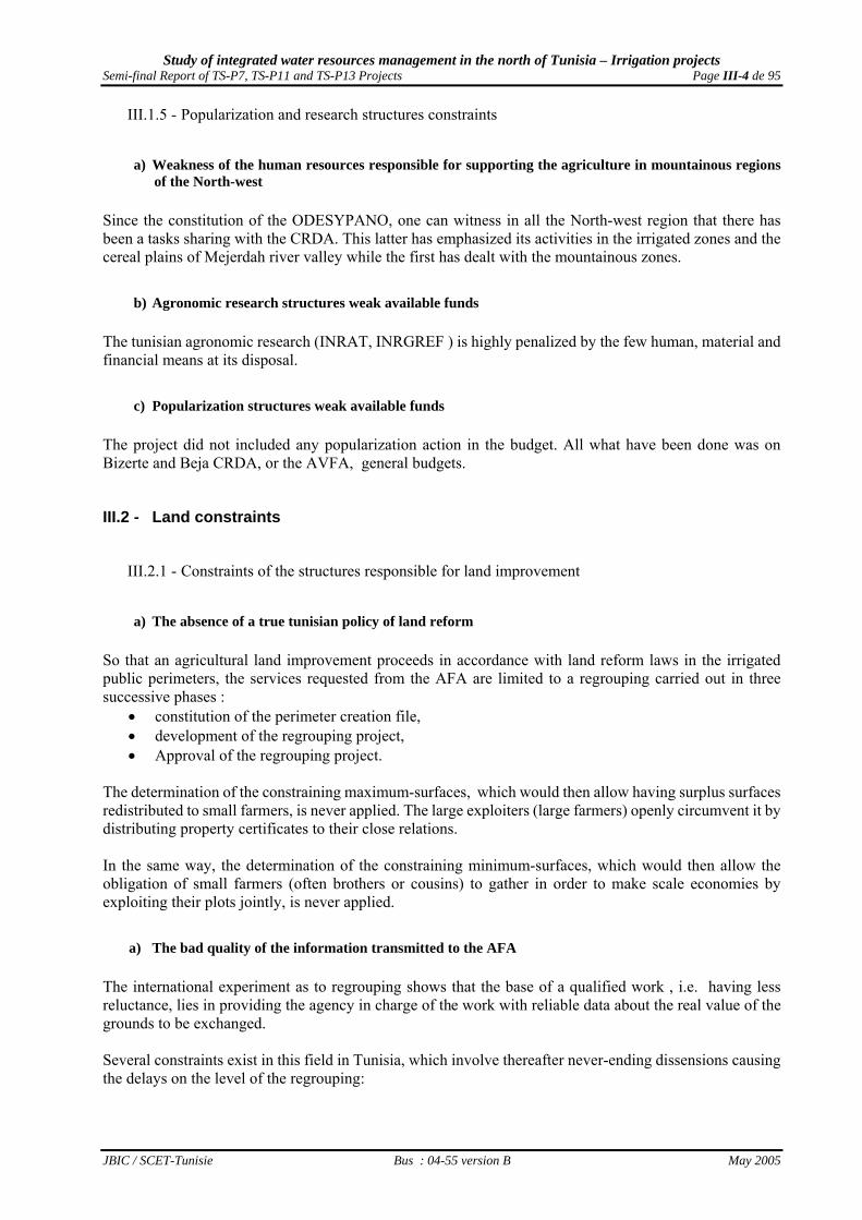
The determination of the constraining maximum-surfaces, which would then allow having surplus surfaces redistributed to small farmers, is never applied. The large exploiters (large farmers) openly circumvent it by distributing property certificates to their close relations. In the same way, the determination of the constraining minimum-surfaces, which would then allow the obligation of small farmers (often brothers or cousins) to gather in order to make scale economies by exploiting their plots jointly, is never applied.
a) The bad quality of the information transmitted to the AFA The international experiment as to regrouping shows that the base of a qualified work , i.e. having less reluctance, lies in providing the agency in charge of the work with reliable data about the real value of the grounds to be exchanged. Several constraints exist in this field in Tunisia, which involve thereafter never-ending dissensions causing the delays on the level of the regrouping:

Study of integrated water resources management in the north of Tunisia – Irrigation projects Semi-final Report of TS-P7, TS-P11 and TS-P13 Projects Page III-5 de 95
JBIC / SCET-Tunisie Bus : 04-55 version B May 2005
Map n°III-1 : Agricultural lands values provided to the AFA for TS-P7 Project two perimeters
Study of integrated water resources management in the north of Tunisia – Irrigation projects Semi-final Report of TS-P7, TS-P11 and TS-P13 Projects Page III-6 de 95
JBIC / SCET-Tunisie Bus : 04-55 version B May 2005
Map n°III-2 : Agricultural lands values provided to the AFA for Goubellat perimeter

Study of integrated water resources management in the north of Tunisia – Irrigation projects Semi-final Report of TS-P7, TS-P11 and TS-P13 Projects Page III-7 de 95
JBIC / SCET-Tunisie Bus : 04-55 version B May 2005
Map n°III-3 : Agricultural lands values provided to the AFA for TS-P13 Project perimeters
Study of integrated water resources management in the north of Tunisia – Irrigation projects Semi-final Report of TS-P7, TS-P11 and TS-P13 Projects Page III-8 de 95
JBIC / SCET-Tunisie Bus : 04-55 version B May 2005
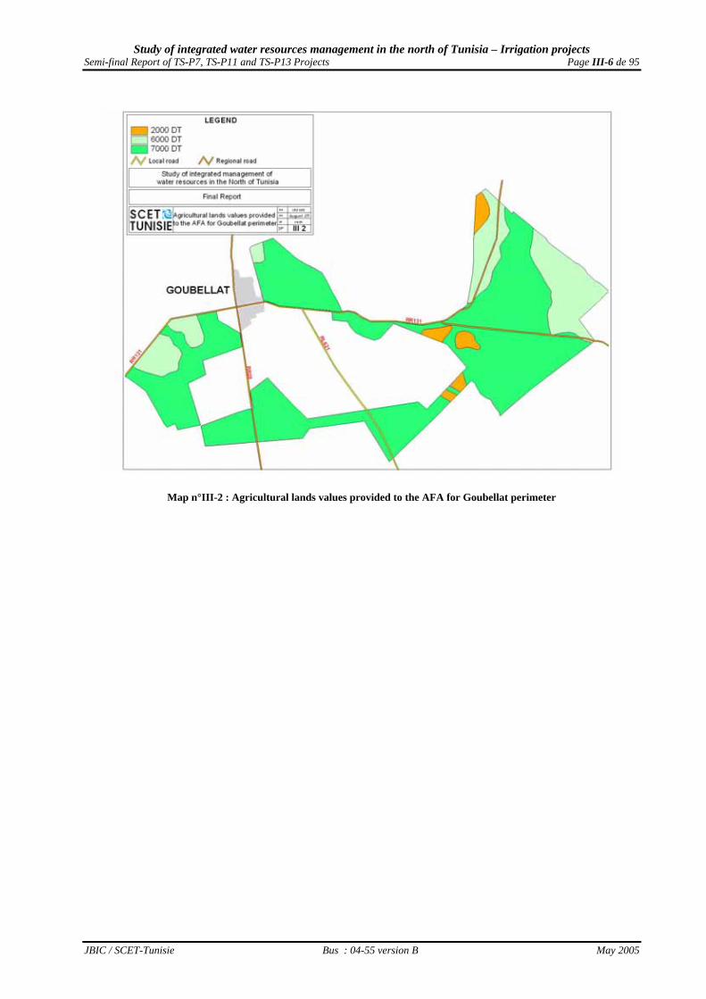
Map n°III-4 : Compartmental after AFA regrouping for the two TS-P7 Project perimeters

Study of integrated water resources management in the north of Tunisia – Irrigation projects Semi-final Report of TS-P7, TS-P11 and TS-P13 Projects Page III-9 de 95
JBIC / SCET-Tunisie Bus : 04-55 version B May 2005
Map n°III-5 : Compartmental after AFA regrouping for Goubellat perimeter

Study of integrated water resources management in the north of Tunisia – Irrigation projects Semi-final Report of TS-P7, TS-P11 and TS-P13 Projects Page III-10 de 95
JBIC / SCET-Tunisie Bus : 04-55 version B May 2005
Map n°III-6 : Compartmental after AFA regrouping for the two TS-P13 Project perimeters

Study of integrated water resources management in the north of Tunisia – Irrigation projects Semi-final Report of TS-P7, TS-P11 and TS-P13 Projects Page III-11 de 95
JBIC / SCET-Tunisie Bus : 04-55 version B May 2005
• the precision of the available pedological studies is sometimes of a scale which is unable to get along with a work of precision ;
• whereas the grounds of an irrigated perimeter are famous of " prohibition " to the assignment
change. It is the grounds exchange value - that considers largely the land speculation - which is used and not its agricultural productivity
For instance, Map n°III-4 of page III-8 presents the value attributed to the grounds provided to AFA for the two perimeters of TS-P7 Project. Map n°III-5 of page III-9 displays the value attributed to the grounds provided to AFA for the Goubellat perimeter of TS-P11 Project and Map n°III-6 of page III-10 the value attributed to the grounds provided to AFA for the two perimeters of TS-P13 Project. These valorisations are in obvious contradiction with the physical potentialities after installation of these five perimeters, like presented respectively in Map n°III-14 of page III-22 for Nefza perimeter, Map n°III-15 of page III-23 for Sejnane perimeter, Map n°III-21 of page III-31 for Goubellat perimeter, Map n°III-29 of page III-41 for Fernana perimeter and Map n°III-30 of page III-42 for Hammam Bourguiba perimeter.
III.2.2 - The validity of the division proposed by the AFA after regrouping For private lands, the regrouping allowed vanishing on the lands concerned by the creation decree of irrigated perimeter the exploitations parcelling out wherever the AFA suggestions were accepted by the population. However, the up to date not-setting of the creation decree of Sejnane perimeter led to the appearance of lands actually arranged for irrigation, but: which were not touched by the regrouping operation of AFA; which does not belong to the perimeter of Sejnane, as demarcated by the available maps at the CRDA
of Bizerte, like the 90.4 ha of the OEP farm ; which may sometimes be subject to housing fast extension, as the 45.6 ha of the sector 5 that has been
proposed to exclusion so as to limit urban development in it. Moreover, in the absence of a real land reform operation and knowing that exploitations having a SAU of less than 2 ha are not viable after the perimeters setting in water, the importance of the number is an important constraint in all the perimeters, except Goubellat.
III.2.3 - Absence of land registration Few private lands are registered in Nefza, Sejnane, Fernana and Hamam Bourguiba perimeters. Even if 86,5% of private lands in Goubellat perimeter are registered within the framework of the old colonial land registry, several private owners did not do register-like everywhere in Tunisia- the last succession transformations and the registering affects indeed legal claimants distributed on 2 generation.
III.2.4 - Rural short term tenancy agreements
a) Goubellat perimeter case In Goubellat perimeter, 2,045 ha of state-owned lands are exploited by private farmers. Except the 1,178 ha exploited by 15 SMVDA which have long term tenancy contracts, there are :

Study of integrated water resources management in the north of Tunisia – Irrigation projects Semi-final Report of TS-P7, TS-P11 and TS-P13 Projects Page III-12 de 95
JBIC / SCET-Tunisie Bus : 04-55 version B May 2005
• 21 beneficiaries of “technician plots” which are recipients of 210 ha and have not had yet long term tenancy contracts;
• 158 former cooperators or ”young farmers” which are recipients of 444 ha and don’t have a
long term tenancy contract for the first, and have not been yet designated by the competent authorities for the seconds;
• 23 private farmers which are recipients of 213 ha and have only a three-year tenancy contract,
which is an insufficient term to receive investment loans from the BNA.
b) The other irrigated perimeters In the same way, 124 ha of state-owned lands in Nefza and 330 ha in Sejnane are exploited by private farmers who have only a three-year tenancy contract.
III.3 - Technical constraints
III.3.1 - Constraints of the mobilized physical potentialities
a) Determination of the mobilized physical potentialities methodology The used methodology is a refinement of the one used to realize the Regional Agricultural Maps “agronomic” layer. The evaluation of the perimeters physical potentialities stem from crossing the topographical constraints related to the fields slope, the climatic constraints linked to the bio climate of the zone and the edaphic constraints of the pedological cover which was the object of an improvement in the project background. It has the objective of identifying and evaluating the arranged lands potentialities for the major irrigated cultivations, in order to come out onto the determination of the best adapted speculations to these physical potentialities, and to seek the most optimum development of irrigated cultivations.
b) The level of the physical potentialities mobilized in TS-P7 project two perimeter Nefza and Sejnane peimeters finally arranged for the irrigation were much more evolved than the perimeters considered in the Project feasibility, evaluation and detailed studies. Thus it is interesting to check the quality of the really mobilized physical potentialities From the level lines of the staff map on 1/25.000th, two Digital Model of Ground (MNT) were established for Sejnane and Nefza perimeters, which are presented both in the Map n°III-7 on page III-13. Slopes calculation carried out on these models are presented in Map n°III-8 of page III-14. This calculation shows that almost all the lands arranged in Sejnane perimeter have a slope low than 6% and are not a constraint for the development. But it’s not the same for Nefza perimeter slopes that are in some places a real constraint for the intensification. One can notice, indeed, that several lands arranged in extension, after the beneficiaries request envisaged in the feasibility study, have slopes higher than 6% and sometimes even higher than 10%, which is a certain constraint for their future development

Study of integrated water resources management in the north of Tunisia – Irrigation projects Semi-final Report of TS-P7, TS-P11 and TS-P13 Projects Page III-13 de 95
JBIC / SCET-Tunisie Bus : 04-55 version B May 2005
Map n°III-7 : MNT of the two TS-P7 Project perimeters

Study of integrated water resources management in the north of Tunisia – Irrigation projects Semi-final Report of TS-P7, TS-P11 and TS-P13 Projects Page III-14 de 95
JBIC / SCET-Tunisie Bus : 04-55 version B May 2005
Map n°III-8 : Topographical constraints in the two TS-P7 Project perimeters

Study of integrated water resources management in the north of Tunisia – Irrigation projects Semi-final Report of TS-P7, TS-P11 and TS-P13 Projects Page III-15 de 95
JBIC / SCET-Tunisie Bus : 04-55 version B May 2005
b.1) Edaphic types met in Nefza perimeter Map n°III-9 of page III-17 presents the pedological cover of Nefza perimeter. It allows to register there 3 great ground classes on various categories of parent rocks :
• slightly evolved grounds from alluvial contribution of low permeability, evolving on clayey and polyhedric alluvia, and presenting pseudogley spots in-depth ( Bouzenna sector );
• slightly evolved grounds from hydromorphic alluvial and colluvial contribution of low
permeability, evolving on clayey and polyhedric marls and sandstones, and prersenting in flat zone a clogging up hydromorphy;
• slightly evolved grounds from alluvial, colluvial or aeolian contribution of good permeability,
evolving on well structured sandy-clayey sandstones, and presenting in slope zones high erosion risks (Ouechtata sector ).
• brown mediterranean grounds evolving on deep,well structured,clayey low glacis colluvia, and rich
with well decomposed organic matter (Bouzenna sector); • calsimagnesic grounds of limestone accumulations on all the glacis surrounding the different
sectors.
b.2) Edaphic types met in Sejnane perimeter Map n°III-9 of page III-17 presents also the pedological cover of Sejnane perimeter. It allows to register there 3 great ground classes evolving on various categories of parent rocks :
• slightly evolved grounds from hydromorphic contribution of low permeability, evolving on clayey and polyhedric alluvia and colluvia, and presenting pseudogley spots in-depth
• vertisols of very low permeability, evolving on marly, very clayey and - having very large
prismatic structure in depth - alluvia and colluvia, impassable in winter and having withdrawal slits and a strong compactness in dry season ;
• and finally, brown grounds evolving on marl-sandy, clayey, quite deep and well structured alluvia
and colluvia, evolving under the influence of an organic matter of mull type, with a stable clayey-ferro-humic complex.
b.3) Constraints of these pedological covers
If the slope is not a morphological constraint in Sejnane perimeter, it is a significant constraint of a broad surface in Nefza perimeter sectors, especially on the level of the extensions. In the two perimeters, the major met physical constraints are :
• a texture constraint, related to a fine to a very fine texture or a relative richness in inflating clays of the original materials of the grounds;
• a depth hydromorphy which locally constitutes a secondary process of ground formation and
evolution in depth horizons, where accumulated over long periods water relatively loaded with soluble salt.
Frequent in the tunisian North to which the plains of Nefza and Sejnane belong, the principal physicochemical constraints met are :

Study of integrated water resources management in the north of Tunisia – Irrigation projects Semi-final Report of TS-P7, TS-P11 and TS-P13 Projects Page III-16 de 95
JBIC / SCET-Tunisie Bus : 04-55 version B May 2005
• the acidity of the majority of these grounds evolving on the absence of limestone; • the poverty and weak decomposition of the organic matter, with a nitrogen lack and a great
phosphorus poverty. In addition, the low humid bio climate, combined with a very strong " useful storage " of the grounds, generate a strong " easily usable storage ", which constitutes an additional constraint when there is a tendency to the hydromorphy. Map n°III-10 of page III-18 for Nefza perimeter, and Map n°III-11 of page III-19 for Sejnane perimeter, allow visualizing the major constraints of the two pedological covers.
b.4) The distribution of the intrinsic physical potentialities of the two perimeter After implementation of the method described in Annex II – “Determination of the agronomic vocations in the irrigated perimeters”, the multi-criterion priority of the intrinsic physical potentialities mobilized by the Project is visualized in Map n°III-12 of page III-20 for Nefza perimeter, and in Map n°III-13 of page III-21 for Sejnane perimeter.
b.5) The distribution of the physical potentialities after development in the two perimeter
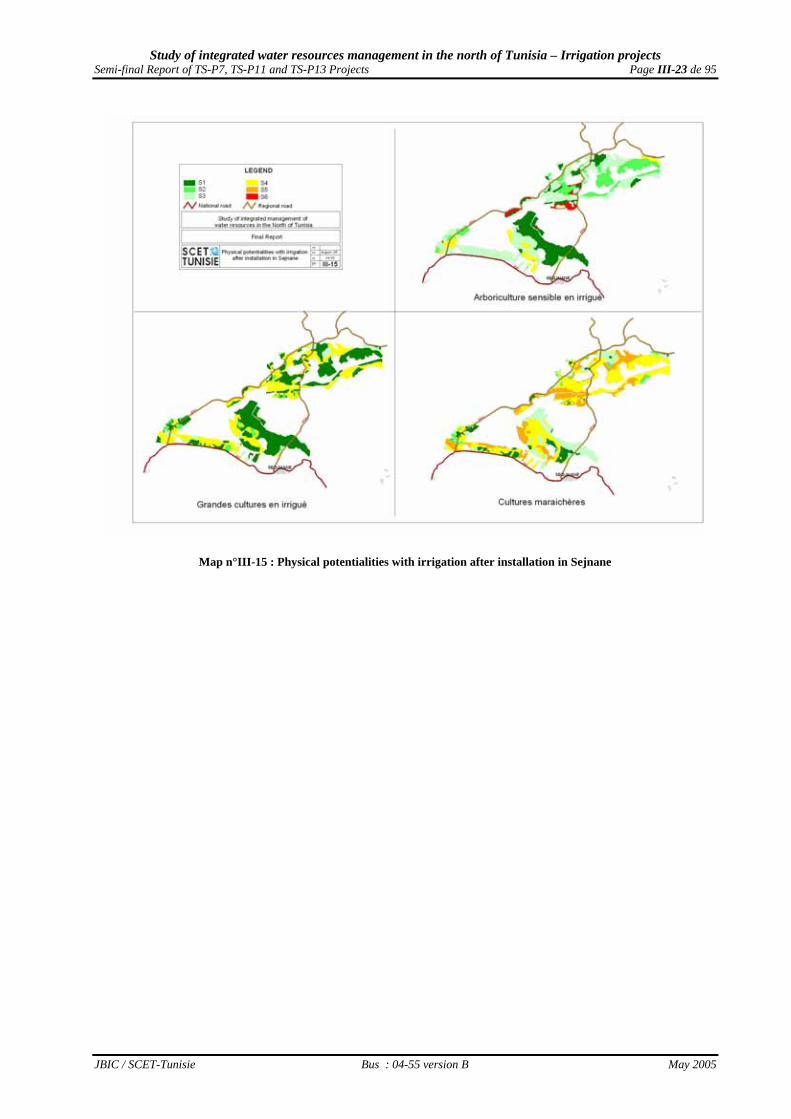
These corrective calculations are justified only by the fact that the Project contains a drainage network realization, which must allow decreasing the grounds hydromorphy. In addition, it is clear that the irrigated agricultural development of very slightly or slightly deep grounds will require on behalf of the interested farmers the implementation of certain physical and/or agronomic interventions allowing the deepening of the exploitable horizon from the roots, like the sub-soiling and the digging of well dimensioned holes of plantation. Moreover, the farmers will obviously make the choice of species adapted as well as possible to the edaphic background of the perimeter, which will allow a better development of water and used grounds. All these actions are explained by the corrected multi-criterion priority of the physical potentialities after development, which are visualized in Map n°III-14 on page III-22 for Nefza perimeter, and in Map n°III-15 of page III-23 for Sejnane perimeter.
c) Level of physical potentialities mobilized in TS-P11 Project perimeter The finally arranged perimeter for irrigation in Goubellat plain was much more evolved than the perimeter studied in the feasibility, evaluation and first detailed studies (realized by SERAH in 1996) of the Project. Therefore, it is interesting to check the quality of the really mobilized physical potentialities. The potentialities evaluation in the perimeters grounds was carried out on the basis of morphological and analytical characteristics of the perimeter pedological cover, provided by Grounds Direction.
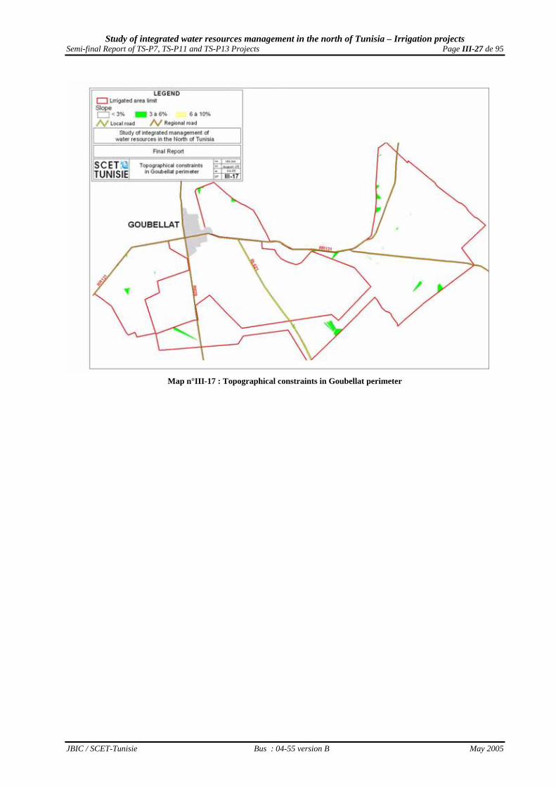
c.1) The slope level of the arranged grounds From the level lines of the staff map on 1/25.000th, a Digital Model of Ground (MNT) was established, which is presented both in the Map n°III-16 on page III-24. The slopes calculation carried out on this model, which is presented in the Map n°III-17 on page III-27, shows that the arranged perimeter grounds are of a slope lower than 6%, and are not a constraint for its development.

Study of integrated water resources management in the north of Tunisia – Irrigation projects Semi-final Report of TS-P7, TS-P11 and TS-P13 Projects Page III-17 de 95
JBIC / SCET-Tunisie Bus : 04-55 version B May 2005
Map n°III-9 : Pedological cover of the two TS-P7 Project perimeters

Study of integrated water resources management in the north of Tunisia – Irrigation projects Semi-final Report of TS-P7, TS-P11 and TS-P13 Projects Page III-18 de 95
JBIC / SCET-Tunisie Bus : 04-55 version B May 2005
Map n°III-10 : Pedological constraints of Nefza perimeter

Study of integrated water resources management in the north of Tunisia – Irrigation projects Semi-final Report of TS-P7, TS-P11 and TS-P13 Projects Page III-19 de 95
JBIC / SCET-Tunisie Bus : 04-55 version B May 2005
Map n°III-11 : Pedological constraints of Sejnane perimeter

Study of integrated water resources management in the north of Tunisia – Irrigation projects Semi-final Report of TS-P7, TS-P11 and TS-P13 Projects Page III-20 de 95
JBIC / SCET-Tunisie Bus : 04-55 version B May 2005
Map n°III-12 : Physical potentialities with irrigation before installation in Nefza

Study of integrated water resources management in the north of Tunisia – Irrigation projects Semi-final Report of TS-P7, TS-P11 and TS-P13 Projects Page III-21 de 95
JBIC / SCET-Tunisie Bus : 04-55 version B May 2005
Map n°III-13 : Physical potentialities with irrigation before installation in Sejnane

Study of integrated water resources management in the north of Tunisia – Irrigation projects Semi-final Report of TS-P7, TS-P11 and TS-P13 Projects Page III-22 de 95
JBIC / SCET-Tunisie Bus : 04-55 version B May 2005
Map n°III-14 : Physical potentialities with irrigation after installation in Nefza
Study of integrated water resources management in the north of Tunisia – Irrigation projects Semi-final Report of TS-P7, TS-P11 and TS-P13 Projects Page III-23 de 95
JBIC / SCET-Tunisie Bus : 04-55 version B May 2005
Map n°III-15 : Physical potentialities with irrigation after installation in Sejnane

Study of integrated water resources management in the north of Tunisia – Irrigation projects Semi-final Report of TS-P7, TS-P11 and TS-P13 Projects Page III-24 de 95
JBIC / SCET-Tunisie Bus : 04-55 version B May 2005
Map n°III-16 : MNT of Goubellat perimeter

Study of integrated water resources management in the north of Tunisia – Irrigation projects Semi-final Report of TS-P7, TS-P11 and TS-P13 Projects Page III-25 de 95
JBIC / SCET-Tunisie Bus : 04-55 version B May 2005
c.2) Edaphic types met in Goubellat perimeter Map n°III-18 of page III-28 presents the pedological cover of Goubellat perimeter. It allows to register there 3 great classes of ground evolving on various categories of parent rocks :
• slightly evolved grounds, from contribution or erosion, evolved on alluvia and colluvia, on clayey crusts and/or chalky encrusts more or less tender or on sandy geological rocks ;
• isohumic grounds evolving on alluvia and colluvia or on clayey crusts and/or chalky encrusts more or less tender or on sandy geological rocks ;
• at the end, calsimagnesic grounds with clayey accumulations or evolving on clayey nodules alluvia and colluvia.
c.3) Constraints of this pedological cover
If the slope is not anywhere a morphological constraint in Goubellat perimeter, physical constraints were met :
• a depth constraint, related to the presence of limestone accumulations at average depth taking the form either of encrust and/or crust or a contrast texture between the surface and depth horizons ;
• a texture constraint, related to a fine and to a very fine texture or to a relative richness in inflating clays of the original materials of the grounds.
• a depth hydromorphy which is locally a pedogenese secondary process on the level of deep horizons where accumulated over long periods waters relatively loaded with soluble salts.
Frequent in tunisian “Tell” to which belongs Goubellat plain, the major met physico chemical constraints are :
• average to high carbonate of calcium contents, with a homogeneity of their distribution in the pedological profile ;
• appearance of salinity nature affecting the deep horizons and in certain cases the totality of the profile and acting individually or in partnership with the process of hydromorphy.
Moreover, the semiarid bio climate, combined with a low " useful storage " of the grounds leads to a very low " easily usable storage ", which constitutes an additional constraint. Map n°III-19 of page III-29 allows visualizing the major constraints of this pedological cover.
c.4) Distribution of the intrinsic physical potentialities of Goubellat perimeter After the implementation of the method described in Annex II – “Determination of the agronomic vocations in the irrigated perimeters”, the multi-criterion priority of the mobilized intrinsic physical potentialities by the Project, is visualized in Map n°III-20 of page III-30.
c.5) Distribution of the physical potentialities after installation in Goubellat perimeter These correcting calculations are justified by the only fact that the Project contains a drainage network realization, which must allow controlling the salinity hydromorphy and evolution. In addition, it is clear that the irrigated agricultural development of slightly or slightly deep grounds will require on behalf of the interested farmers the implementation of certain physical and/or agronomic interventions allowing the deepening of the exploitable horizon from the roots, like the sub-soiling and the digging of well dimensioned holes of plantation. Moreover, the farmers will obviously make the choice of species adapted as well as possible to the edaphic perimeter background, which will allow a better development of water and the used grounds.

Study of integrated water resources management in the north of Tunisia – Irrigation projects Semi-final Report of TS-P7, TS-P11 and TS-P13 Projects Page III-26 de 95
JBIC / SCET-Tunisie Bus : 04-55 version B May 2005
All these actions are explained in the corrected multi-criterion priority of the physical potentialities after installation, which is visualized in Map n°III-21 of page III-31.
d) Level of physical potentialities mobilized in the perimeters of TS-P13 Project Fernana and Hammam Bourguiba perimeters finally arranged for irrigation were slightly evolved than the perimeters studied in the feasibility, evaluation and detailed studies of the Project. Thus, it is interesting to check the quality of the really mobilized physical potentialities. The evaluation of the perimeters ground potentialities was carried out on the basis of morphological and analytical characteristic of the perimeters pedological covers provided by the Grounds Direction. The type of the parent rock prevailing in the area is mio-pliocene consisting of gray marls and clays.
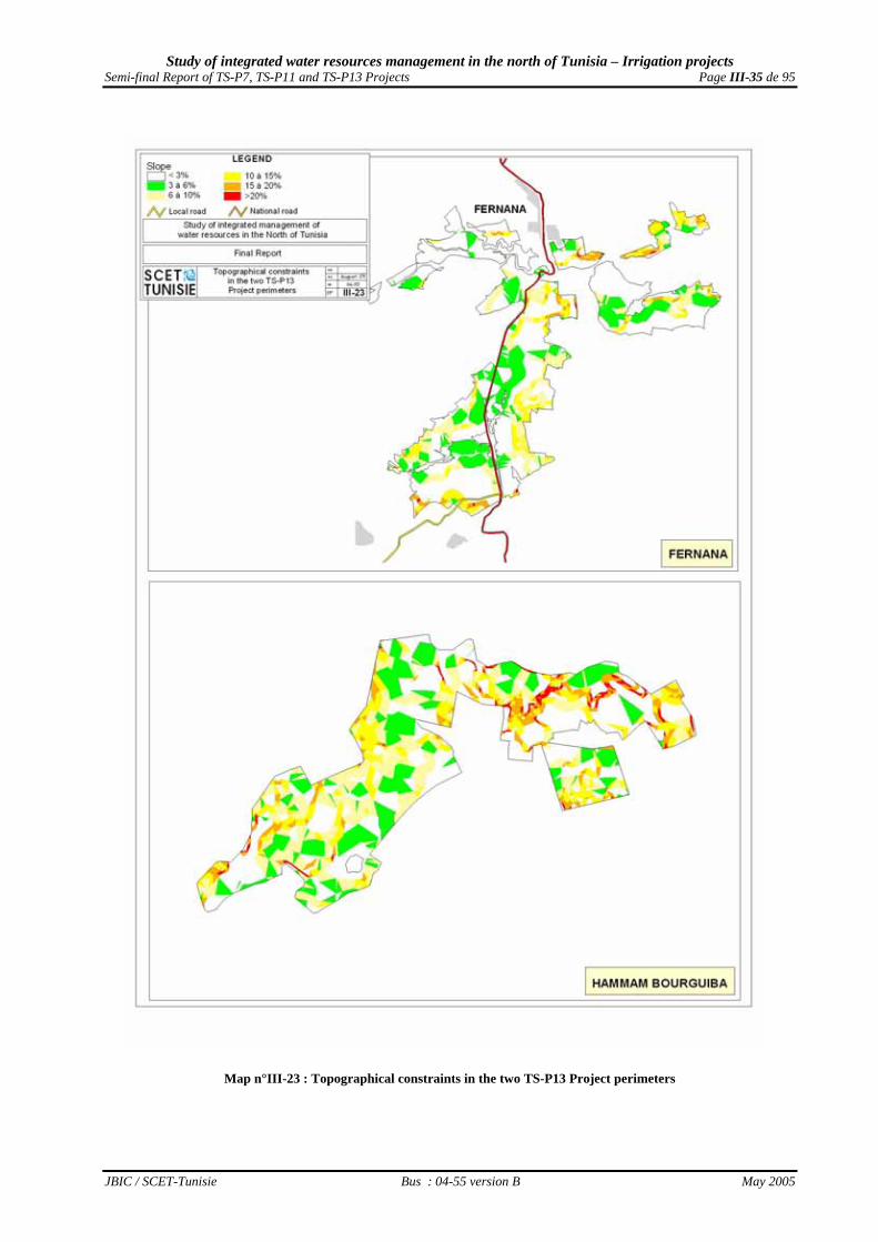
d.1) The arranged grounds slope level From the level lines of the staff map on 1/25.000th scale, two Digital Models of Grounds (MNT) were established for Fernana and Hammam Bourguiba perimeters and presented in Map n°III-22 of page III-32. The slopes calculation made on those two models are presented in Map n°III-23 of page III-35. This calculation shows that the slopes of the two perimeters arranged grounds are in some places a real constraint to the intensification, because they represent slopes higher than 6% and sometimes even higher than 15%, which limits their development at drop by drop irrigated plantations.
d.2) Edaphic types met in Fernana perimeter The pedological cover of Fernana perimeter is presented in Map n°III-24 of page III-36 that registers 3 great classes and 4 types of ground • slightly evolved grounds from alluvial contribution of good permeability, evolving on alluvia of river
terraces weak slope, having a clayey texture and polyhedric structure on surface and in depth . • topolithomorphic vertisols with possible external drainage, evolving on marl colluvia of slightly
inclined piedmont, having a fine and friable structure on surface and polyhedric in depth . • topolithomorphic vertisols with defective external drainage, evolving on marl alluvia in low zone, of a
clayey texture very rich in inflating clay and of prismatic structure very broad in depth, impracticable in winter and having withdrawal slits and a strong compactness in dry season ;
• Mediterranean brown grounds slightly washed evolving on colluvia of Magroun, Ghazala and El
Hazehaza river terraces, having a light texture, deep and well-structured , but poor in organic matter and presenting tasks of hydromorphy related to a water stagnation in rainy period.
d.3) Edaphic types met in Hammam Bourguiba perimeter
Map n°III-24 of page III-36 presents the pedological cover of Hammam Bourguiba perimeter too. It allows registering there 3 great classes and 5 types of grounds : • slightly evolved grounds of alluvial contribution, hydromorphic and having low permeability,
evolving on alluvia of Mellila river terraces weak slope, having a silty texture on surface and finer in depth, and a polyhedric structure, presenting a clogging up hydromorphy .
• slightly evolved grounds of alluvial contribution of good permeability, evolving on alluvia of river
terraces weak slope, having a clayey texture and polyhedric structure on surface and in depth .
Study of integrated water resources management in the north of Tunisia – Irrigation projects Semi-final Report of TS-P7, TS-P11 and TS-P13 Projects Page III-27 de 95
JBIC / SCET-Tunisie Bus : 04-55 version B May 2005
Map n°III-17 : Topographical constraints in Goubellat perimeter

Study of integrated water resources management in the north of Tunisia – Irrigation projects Semi-final Report of TS-P7, TS-P11 and TS-P13 Projects Page III-28 de 95
JBIC / SCET-Tunisie Bus : 04-55 version B May 2005
Map n°III-18 : Pedological cover of Goubellat perimeter

Study of integrated water resources management in the north of Tunisia – Irrigation projects Semi-final Report of TS-P7, TS-P11 and TS-P13 Projects Page III-29 de 95
JBIC / SCET-Tunisie Bus : 04-55 version B May 2005
Map n°III-19 : Pedological constraints of Goubellat perimeter

Study of integrated water resources management in the north of Tunisia – Irrigation projects Semi-final Report of TS-P7, TS-P11 and TS-P13 Projects Page III-30 de 95
JBIC / SCET-Tunisie Bus : 04-55 version B May 2005
Map n°III-20 : Physical potentialities with irrigation before installation in Goubellat perimeter

Study of integrated water resources management in the north of Tunisia – Irrigation projects Semi-final Report of TS-P7, TS-P11 and TS-P13 Projects Page III-31 de 95
JBIC / SCET-Tunisie Bus : 04-55 version B May 2005
Map n°III-21 : Physical potentialities with irrigation after installation in Goubellat perimeter

Study of integrated water resources management in the north of Tunisia – Irrigation projects Semi-final Report of TS-P7, TS-P11 and TS-P13 Projects Page III-32 de 95
JBIC / SCET-Tunisie Bus : 04-55 version B May 2005
Map n°III-22 : MNT of TS-P13 Project two perimeter

Study of integrated water resources management in the north of Tunisia – Irrigation projects Semi-final Report of TS-P7, TS-P11 and TS-P13 Projects Page III-33 de 95
JBIC / SCET-Tunisie Bus : 04-55 version B May 2005
• slightly evolved grounds of alluvial contribution of vertic character, evolving on right bank of Barbara river on alluvia of clayey texture and fine polyhedric structure on surface and prismatic in depth with tasks of pseudogley;
• topolithomorphic vertisols of very low permeability, evolving on marl colluvia of very clayey texture
rich in inflating clay and of very broad prismatic structure in depth, impraticable in winter and having withdrawal slits and a strong compactness in dry season .
• and finally, brown grounds more or less washed and evolving on clay-sandy colluvia and deteriorated
marls, not chalky, quite deep and well-structured, evolving under the influence of an organic matter of mull type, with a stable clay-ferro-humic complex in the surface.
d.4) Constraints of these pedological covers
the slope is an important morphological constraint for a broad surface in Fernana and Hammam Bourguiba perimeters. The physical constraints met in the two perimeters are :
• a texture constraint, related to a fine to very fine texture or to a relative richness with clays inflating the grounds original materials;
• an depth hydromorphy which is locally a secondary process of ground formation and evolution in deep horizons where the water accumulated over long periods is slightly loaded with soluble salt.
In the tunisian North, to which the plains of Fernana and Hammam Bourguiba belong, the Frequent major physicochemical met constraints are :
• the acidity of the majority of these grounds evolving almost with absence of clay; • the organic matter poverty and weak decomposition, with a nitrogen lack and a great phosphorus
poverty. In addition, the low humid bio climate, combined with a very strong " useful storage " of the grounds, generate a strong " easily usable storage ", which constitutes an additional constraint in the case of a tendency to the hydromorphy. Map n°III-25 of page III-37 for Fernana perimeter, and Map n°III-26 of page III-38 for Hammam Bourguiba perimeter, allow visualizing the major constraints of the two pedological covers.
d.5) Distribution of the intrinsic physical potentialities in TS-P13 Project perimeters After the implementation of the method described in Annex II – “Determination of the agronomic vocations in the irrigated perimeters”, the multi-criterion priority of the intrinsic physical potentialities mobilized by the Project is visualized in Map n°III-27 of page III-39 for Fernana perimeter, and in Map n°III-28 of page III-40 for Hammam Bourguiba perimeter.
d.6) Distribution of the physical potentialities after installation in TS-P13 Project perimeters These correcting calculations are justified only by the fact that the Project contains the drainage network realization which must allow the decrease of the grounds’ hydromorphy. In addition, it is clear that the irrigation agricultural development of very slightly or slightly deep grounds will require on behalf of the interested farmers the implementation of certain physical and/or agronomic interventions allowing the deepening of the exploitable horizon from the roots, like the sub-soiling and the digging of well-dimensioned plantation holes.

Study of integrated water resources management in the north of Tunisia – Irrigation projects Semi-final Report of TS-P7, TS-P11 and TS-P13 Projects Page III-34 de 95
JBIC / SCET-Tunisie Bus : 04-55 version B May 2005
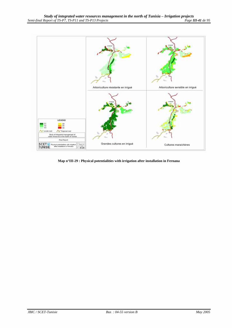
Moreover, the farmers will obviously make the choice of the species that adapt as well as possible to the edaphic perimeter background, which will allow a better development of water and the used grounds. All these actions are explained by the corrected multi-criterion priority of the physical potentialities after installation, which is visualized in Map n°III-29 of page III-41 for Fernana perimeter, and in Map n°III-30 of page III-42 for Hammam Bourguiba perimeter.
III.3.2 - Constraints on the level of the hydraulic equipments for drinking water supply Considering the conditions of realization of the pipeline doubling, no constraint to the drinking water supply is to be announced.
III.3.3 - Constraints on the level of the hydraulic equipments for cultivations irrigation
a) Hydraulic equipment installed by TS-P7 Project
a.1) Validity of the pumping out systems installed by TS-P7 Project In Nefza perimeter, the constraints of the hydraulic complex are dependent :
on the direct pricking in the network for certain zones, which can create problems during the network operating ;
on the problem of stability and floatability of the floating pontoon; on the recurrent need of a very strict maintenance on the level of the catchment and pumping civil
engineering works on the floating pontoon ; In Sejnane perimeter, the constraints of the hydraulic complex are dependent :
on the high solid load on the level of the catchments, which is actually well observed on the level of the settling tank and can create significant problems on the level of the distribution network : this load is essentially due to the erodability of the drainage ditches and of Sejnane canal, but also to too weak filtration equipment installed upstream the network ;
on the flooding of the civil engineering works which were, however, already raised up during the
works, but remain under the floods threat; on the recurrent need of a very strict maintenance of the catchment and pumping civil engineering
works.
a.2) Validity of irrigation and track networks installed by TS-P7 Project Map n°III-31 of page III-43 visualizes the networks installed in Nefza perimeter, for which the recorded constraints during the mission arise as the following :
the sharing use of many terminals by several farmers (named “bornes-foyers”), which will create a problem of management and equipment ;
the problem of ground stability which are often very sloping grounds, and consequently a problem of the installed infrastructure;
the problem of the tracks stability on these often very sloping grounds. Map n°III-32 of page III-44 visualizes the networks installed in Sejnane perimeter, for which the recorded constraints during the mission arise as the following :
the sharing use of many terminals by several farmers (named “bornes-foyers”), which will create a management and equipment problem ;
Study of integrated water resources management in the north of Tunisia – Irrigation projects Semi-final Report of TS-P7, TS-P11 and TS-P13 Projects Page III-35 de 95
JBIC / SCET-Tunisie Bus : 04-55 version B May 2005
Map n°III-23 : Topographical constraints in the two TS-P13 Project perimeters

Study of integrated water resources management in the north of Tunisia – Irrigation projects Semi-final Report of TS-P7, TS-P11 and TS-P13 Projects Page III-36 de 95
JBIC / SCET-Tunisie Bus : 04-55 version B May 2005
Map n°III-24 : Pedological cover of the two TS-P13 Project perimeters

Study of integrated water resources management in the north of Tunisia – Irrigation projects Semi-final Report of TS-P7, TS-P11 and TS-P13 Projects Page III-37 de 95
JBIC / SCET-Tunisie Bus : 04-55 version B May 2005
Map n°III-25 : Pedological constraints of Fernana perimeter

Study of integrated water resources management in the north of Tunisia – Irrigation projects Semi-final Report of TS-P7, TS-P11 and TS-P13 Projects Page III-38 de 95
JBIC / SCET-Tunisie Bus : 04-55 version B May 2005
Map n°III-26 : Pedological constraints of Hammam Bourguiba perimeter

Study of integrated water resources management in the north of Tunisia – Irrigation projects Semi-final Report of TS-P7, TS-P11 and TS-P13 Projects Page III-39 de 95
JBIC / SCET-Tunisie Bus : 04-55 version B May 2005
Map n°III-27 : Physical potentialities with irrigation before installation in Fernana perimeter

Study of integrated water resources management in the north of Tunisia – Irrigation projects Semi-final Report of TS-P7, TS-P11 and TS-P13 Projects Page III-40 de 95
JBIC / SCET-Tunisie Bus : 04-55 version B May 2005
Map n°III-28 : Physical potentialities with irrigation before installation in Hammam Bourguiba
Study of integrated water resources management in the north of Tunisia – Irrigation projects Semi-final Report of TS-P7, TS-P11 and TS-P13 Projects Page III-41 de 95
JBIC / SCET-Tunisie Bus : 04-55 version B May 2005
Map n°III-29 : Physical potentialities with irrigation after installation in Fernana

Study of integrated water resources management in the north of Tunisia – Irrigation projects Semi-final Report of TS-P7, TS-P11 and TS-P13 Projects Page III-42 de 95
JBIC / SCET-Tunisie Bus : 04-55 version B May 2005
Map n°III-30 : Physical potentialities with irrigation after installation in Hammam Bourguiba perimeter

Study of integrated water resources management in the north of Tunisia – Irrigation projects Semi-final Report of TS-P7, TS-P11 and TS-P13 Projects Page III-43 de 95
JBIC / SCET-Tunisie Bus : 04-55 version B May 2005
Map n°III-31 : Hydraulic network of Nefza perimeter

Study of integrated water resources management in the north of Tunisia – Irrigation projects Semi-final Report of TS-P7, TS-P11 and TS-P13 Projects Page III-44 de 95
JBIC / SCET-Tunisie Bus : 04-55 version B May 2005
Map n°III-32 : Hydraulic network of Sejnane perimeter

Study of integrated water resources management in the north of Tunisia – Irrigation projects Semi-final Report of TS-P7, TS-P11 and TS-P13 Projects Page III-45 de 95
JBIC / SCET-Tunisie Bus : 04-55 version B May 2005
the fragility of the track network ; the lack of a windbreak network in this very windy corridor ; the erosion threat to the irrigation infrastructures along the principal rivers crossing the perimeter
(landslides, mass movements, undermining of the banks).
b) Hydraulic equipment installed by TS-P11 Project
b.1) Validity of the installed pumping out systems installed by TS-P11 Project The constraints of the hydraulic complex are limited to :
• the high solid load of the pumped water in Mejerdah river ; • sensitivity of the submersible pumps of the pumping out station ; • the need for a strict maintenance without any faults for the filtration system to protect the pumping
infrastructure.
b.2) Validity of irrigation networks installed by TS-P11 Project Map n°III-33 of page III-47 visualizes the networks installed in Goubellat perimeter, for which the recorded constraints during the mission arise as the following:
• the flow limitation on the level of the terminal to 0,4 L /S /ha appears constraining for making the infrastructure more profitability.
• the available demarcation, pressures and flows on the terminals limit the optimization of the choice in irrigation equipment.
• the sharing of certain terminals by several farmers (named “bornes-foyers”) will create a management problem.
• the existence of several terminals on large farms will limit the choice of a high-performance equipment (roller, swivelling ramps, front ramps, ...).
c) Hydraulic equipment installed by TS-P13 Project
c.1) Validity of the upstream pumping out system installed by TS-P13 Project In Fernana perimeter, the constraints of the hydraulic complex are limited to :
• the instability of the hill being located between the floating station and the pumping out station. • the absence of fences around the tank.
In Hammam Bourguiba perimeter, the constraints of the hydraulic complex are ranged by importance order :
• the floating installation on the pond of Zouitina dam, which requires a continuous supervision for the perimeter water supply .
• the instability of the ground being located between the floating station and the pumping out station. • the absence of fences around the tank.
c.2) Validity of irrigation networks installed by TS-P13 Project
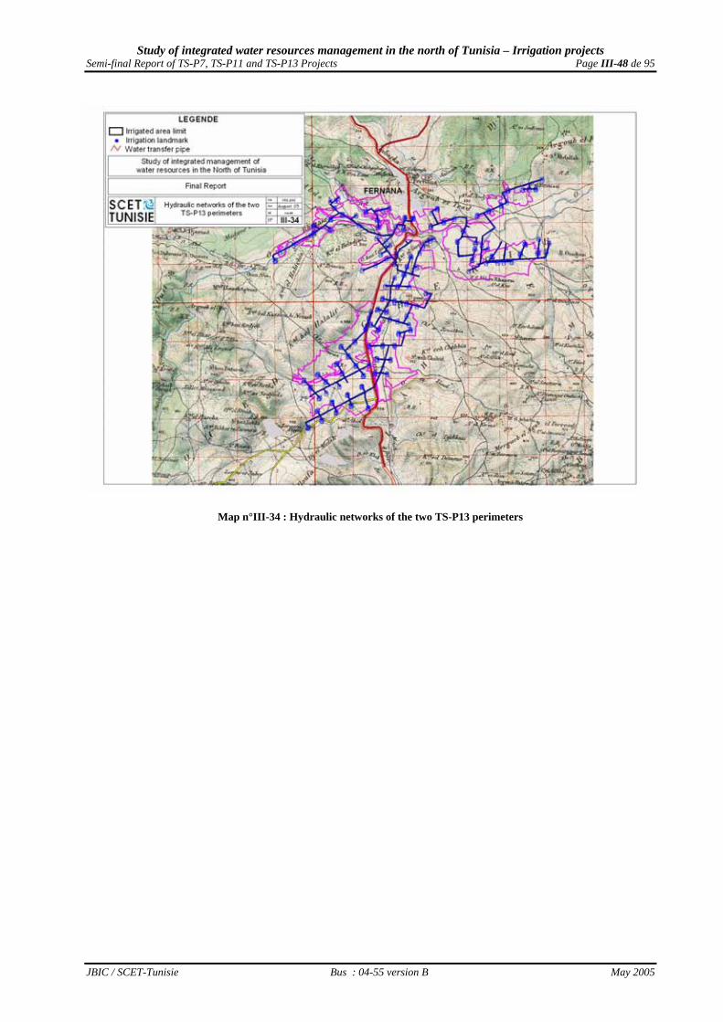
Map n°III-34 of page III-48 visualizes the networks installed in Fernana perimeter and Map n°III-35 of page III-49 the networks installed in Hammam Bourguiba perimeter. The constraints raised during the mission on these two network sets arise as the following :
• the sharing use of the terminals by several farmers (named “bornes-foyers”), which will cause a management and equipment problem ;
• the instability of some arranged inclined fields, which causes a loss of the grounds by slipping and the degradation of the tracks network ;
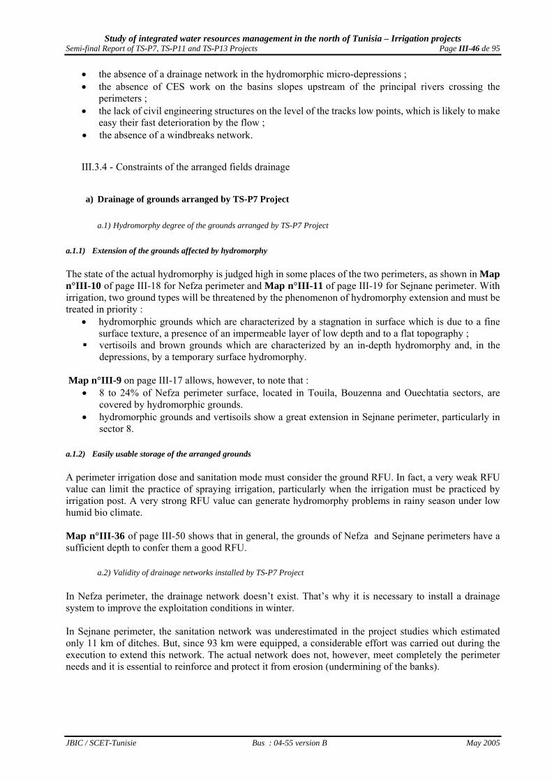
Study of integrated water resources management in the north of Tunisia – Irrigation projects Semi-final Report of TS-P7, TS-P11 and TS-P13 Projects Page III-46 de 95
JBIC / SCET-Tunisie Bus : 04-55 version B May 2005
• the absence of a drainage network in the hydromorphic micro-depressions ; • the absence of CES work on the basins slopes upstream of the principal rivers crossing the
perimeters ; • the lack of civil engineering structures on the level of the tracks low points, which is likely to make
easy their fast deterioration by the flow ; • the absence of a windbreaks network.
III.3.4 - Constraints of the arranged fields drainage
a) Drainage of grounds arranged by TS-P7 Project
a.1) Hydromorphy degree of the grounds arranged by TS-P7 Project a.1.1) Extension of the grounds affected by hydromorphy The state of the actual hydromorphy is judged high in some places of the two perimeters, as shown in Map n°III-10 of page III-18 for Nefza perimeter and Map n°III-11 of page III-19 for Sejnane perimeter. With irrigation, two ground types will be threatened by the phenomenon of hydromorphy extension and must be treated in priority :
• hydromorphic grounds which are characterized by a stagnation in surface which is due to a fine surface texture, a presence of an impermeable layer of low depth and to a flat topography ;
vertisoils and brown grounds which are characterized by an in-depth hydromorphy and, in the depressions, by a temporary surface hydromorphy.
Map n°III-9 on page III-17 allows, however, to note that :
• 8 to 24% of Nefza perimeter surface, located in Touila, Bouzenna and Ouechtatia sectors, are covered by hydromorphic grounds.
• hydromorphic grounds and vertisoils show a great extension in Sejnane perimeter, particularly in sector 8.
a.1.2) Easily usable storage of the arranged grounds A perimeter irrigation dose and sanitation mode must consider the ground RFU. In fact, a very weak RFU value can limit the practice of spraying irrigation, particularly when the irrigation must be practiced by irrigation post. A very strong RFU value can generate hydromorphy problems in rainy season under low humid bio climate. Map n°III-36 of page III-50 shows that in general, the grounds of Nefza and Sejnane perimeters have a sufficient depth to confer them a good RFU.
a.2) Validity of drainage networks installed by TS-P7 Project In Nefza perimeter, the drainage network doesn’t exist. That’s why it is necessary to install a drainage system to improve the exploitation conditions in winter. In Sejnane perimeter, the sanitation network was underestimated in the project studies which estimated only 11 km of ditches. But, since 93 km were equipped, a considerable effort was carried out during the execution to extend this network. The actual network does not, however, meet completely the perimeter needs and it is essential to reinforce and protect it from erosion (undermining of the banks).

Study of integrated water resources management in the north of Tunisia – Irrigation projects Semi-final Report of TS-P7, TS-P11 and TS-P13 Projects Page III-47 de 95
JBIC / SCET-Tunisie Bus : 04-55 version B May 2005
Map n°III-33 : Goubellat perimeter hydraulic networks
Study of integrated water resources management in the north of Tunisia – Irrigation projects Semi-final Report of TS-P7, TS-P11 and TS-P13 Projects Page III-48 de 95
JBIC / SCET-Tunisie Bus : 04-55 version B May 2005
Map n°III-34 : Hydraulic networks of the two TS-P13 perimeters
Study of integrated water resources management in the north of Tunisia – Irrigation projects Semi-final Report of TS-P7, TS-P11 and TS-P13 Projects Page III-49 de 95
JBIC / SCET-Tunisie Bus : 04-55 version B May 2005
Map n°III-35 : Hammam Bourguiba perimeter hydraulic networks

Study of integrated water resources management in the north of Tunisia – Irrigation projects Semi-final Report of TS-P7, TS-P11 and TS-P13 Projects Page III-50 de 95
JBIC / SCET-Tunisie Bus : 04-55 version B May 2005
Map n°III-36 : RFU of TS-P7 Project two perimeter grounds

Study of integrated water resources management in the north of Tunisia – Irrigation projects Semi-final Report of TS-P7, TS-P11 and TS-P13 Projects Page III-51 de 95
JBIC / SCET-Tunisie Bus : 04-55 version B May 2005
A detailed study (APD) should be launched in order to estimate clearly the needs regarding the installation drainage network in Nefza perimeter and its reinforcement in Sejnane perimeter.
b) Drainage of the grounds arranged by TS-P11 Project
b.1) The degree of hydromorphy of the arranged grounds by TS-P7 Project b.1.1) Extension of the grounds affected by hydromorphy As Map n°III-19 of page III-29 shows it, the state of the actual hydromorphy is judged high in some places of Goubellat perimeter, in particular the part skirting Behima river in the joining point with Melah river. This hydromorphy is due in general to the existence of a perched phreatic sheet. With the irrigation, the necessary washing practice to maintain a correct salinity level, and the water loss related to the effectiveness of irrigation networks, the risk of a marked hydromorphy extension is accentuated, particularly for the SMVDA lands “ Marzougua “, “ Charfeddine “, “ Regma “ and “ Hadef “ b.1.2) Arranged grounds easily usable pond The irrigation dose must consider the Easily Usable Pond (RFU) by the plants of stored water in the ground. With a daily average evapo perspiration of 7 mm /D during rush month, calculations were carried out for a dry year with a value of 8,5 mm / D during rush month. As shown in Map n°III-37 on page III-53, it’s the slightly or very slightly deep grounds that present a very weak RFU. This situation leads to recommend the limitation of spraying irrigation practice there, particularly if this type of irrigation must be practiced by station.
b.2) Validity of drainage networks installed by TS-P11 Project The drainage network arranged during the perimeter realization consisted in rehabilitating the existing network (24 km) and creating 1 km of ditches. So, this network is conceived to fight against the external contributions coming from the river basins which feed the major rivers crossing the perimeter. So that this network can play its role perfectly, it is of primary importance to reinforce the existing network by a secondary one of drains or ditches, in order to minimize the hydromorphy risks.
c) Drainage of grounds arranged by TS-P13 Project The drainage was limited in the Detailed Study to a simple sanitation network. In Fernana the works also were only partially realized confronted with the concerns showed by the beneficiaries of the plots located in the micro depressions which should had rather been equipped with a real drainage network. In Hammam Bourguiba also, it was limited in the Detailed Study to a sanitation network that its works have not been started because of land conflicts between beneficiaries.
c.1) The degree of hydromorphy of the arranged grounds c.1.1) Extension of the grounds affected by hydromorphy Map n°III-25 on page III-37 shows that the actual state of hydromorphy is quite strong in Fernana perimeter, and Map n°III-26 on page III-38 shows that it’s less pronounced in Hammam Bourguiba perimeter which is better drained naturally.

Study of integrated water resources management in the north of Tunisia – Irrigation projects Semi-final Report of TS-P7, TS-P11 and TS-P13 Projects Page III-52 de 95
JBIC / SCET-Tunisie Bus : 04-55 version B May 2005
Even if 25 ha of the not very evolved grounds of alluvial contribution with hydromorphic nature which suffer already from the problem of hydromorphy were included in the perimeter of Hammam Bourguiba, the grounds which are most exposed to the risk of a hydromorphy extension caused by irrigation are the vertisols which cover 650 ha in Fernana, but only 280 ha in Hammam Bourguiba. c.1.2) Easily usable pond of the arranged grounds A perimeter irrigation and sanitation modes must consider the ground RFU. In fact, a very weak RFU value can limit the practice of the spraying irrigation, in particular when the irrigation must be practiced by station, and a very strong RFU value under low humid bio climate can generate hydromorphy problems in rainy season. In fact, under this low humid bio climate, Map n°III-38 on page III-54 shows that in general, grounds of Fernana and Hammam Bourguiba perimeters have a sufficient depth to confer them a good RFU.
c.2) Validity of the installed drainage networks The extension of the sanitation networks was estimated in the Detailed study at 22 km for Fernana perimeter and at 11 km for Hammam Bourguiba perimeter. But, due to problems of population refusal of the idea to see digging ditches crossing their plots, the network was restricted, in particular in Hammam Bourguiba. The drainage network is missing in the two perimeter, whereas it is strongly advised on the level of the plots in micro-plain which suffer from a drainage deficit.
III.4 - Recommendations
III.4.1 - Lessons to be drawn from these constraints to the good development All the the four perimeter recipients located in low humid stage and of the perimeter located in average semiarid stage showed their motivation for the use of irrigation water :
• reiterated requests for extension in Nefza and Sejnane, • clashes during regrouping operations in Sejnane and especially in Hammam Bourguiba, • increase in the number of recipients in Goubellat by the recutting of 2,050 ha of the state-owned
grounds. No " cultural unacceptability " could thus be raised. Several constraints to the good development of the investments authorized by the State explain, however, the problems and the concerns expressed at the time of the participative meetings of the mid-term evaluation mission.
a) Human, institutional and organizational constraints These institutional constraints are linked to the absence of attendant measures financing by the project, and also, to the functioning of the national structures - responsible for the rural development - intrinsic problems:
• lack of coordination between the services • low water price paid by the irrigators compared to maintenance and exploitation costs • lack of money allocated for the agricultural research and popularization

Study of integrated water resources management in the north of Tunisia – Irrigation projects Semi-final Report of TS-P7, TS-P11 and TS-P13 Projects Page III-53 de 95
JBIC / SCET-Tunisie Bus : 04-55 version B May 2005
Map n°III-37 : RFU of Goubellat perimeter grounds

Study of integrated water resources management in the north of Tunisia – Irrigation projects Semi-final Report of TS-P7, TS-P11 and TS-P13 Projects Page III-54 de 95
JBIC / SCET-Tunisie Bus : 04-55 version B May 2005
Map n°III-38 : RFU of TS-P13 Project two perimeters grounds

Study of integrated water resources management in the north of Tunisia – Irrigation projects Semi-final Report of TS-P7, TS-P11 and TS-P13 Projects Page III-55 de 95
JBIC / SCET-Tunisie Bus : 04-55 version B May 2005
Land constraints The regrouping action that have been led by the AFA since 2000 – and not entirely completed in Sejnane peimeter - could not solve the constraints related to land. If the parcelling out was highly reduced, the division of lands into smaller units still exists as well as several SAU exploitations which are: • lower than 2 ha, and should share the use of an irrigation terminal; • lower than 2,5 ha, and that regarding the perimeter development, they will not be viable (regarding the
definition of M/ARH (Cf the study of “the minimum surface of the viable exploitation”, DG/PV, 1986)
b) Financial constraints The financial constraints are related to the lack of the beneficiaries resources even after the starting up of the irrigated agricultural activity, for the nonviable private exploitations according to the definition of the M/ARH, i.e. having a SAU lower than 2 ha. The Project did not, however, envisage any financing to constitute an initial credit limit, while at the same time the land constraints to which the tenants face with some 3-year-contracts of exploitation, and the small owners sharing the use of only one terminal, result in an incapacity to resort to the banking structure to obtain a credit, at the moment when the setting in water requires the acquisition of;
• plot systems of economic irrigation, as recommended in the strategy " Eau XXI "; • means of storage and transportation to facilitate the new productions distribution and sale.
c) Technical constraints Various technical constraints were listed which are caused by several phenomena. Displacements of perimeters limits led sometimes to the mobilization of grounds having more marginal vocations, as in Nefza, Sejnane and Goubellat. Neither the detailed studies nor the hydraulic networks realization considered, however, these displacements for the rotations redimensioning, by decreasing the place of sensitive (difficult) cultivations to the profit of more hardy ones. Consequently, these studies did not redimensioned the water requirements to satisfy, which generally had been in the initial feasibility studies:
• over-estimated for the annual needs • underestimated for July rush needs
In general, the absence of drainage networks and the incomplete realization of sanitation networks planned in the Detailed or Execution studies are bad for all installations sustainability which will be easily damaged in the case of exceptional rainfall events (cf the situation of winter 2004-2005, without irrigation) Finally, the erosion occurring on the slopes surrounding the perimeters can damage the tracks networks and especially clog up the sanitation ditches while harming this network sustainability which is quite summarily carried out in the case of exceptional rainfall events. In addition, two specific problems are added in Goubellat :
• the solid winter load and the summery salinity of the water pumped in Mejerdah river, and especially
• the limitation of the available flow on the level of the terminals to 0,4 L / S / ha only, which limits drastically the irrigated surface in rush month, and thus the intensification rate.

Study of integrated water resources management in the north of Tunisia – Irrigation projects Semi-final Report of TS-P7, TS-P11 and TS-P13 Projects Page III-56 de 95
JBIC / SCET-Tunisie Bus : 04-55 version B May 2005
III.4.2 - The redefinition of the Projects objectives to ensure a good mid-term evaluation : The present mission thinks that a first redefinition of the irrigated perimeters grounds occupation, considering the mobilized potentialities, is imperative. It will allow refining the realized work during the Regional Agricultural Maps drawing up, in order to come off regarding the same methodolgy to “Local Agricultural Maps”. It will also lead to the redefinition of the production objectives in the irrigated perimeters, which considers the real mobilized potentialities. This work could be refined during the missions of the perimeters functioning supervision-evaluation. The first, being realized in 2 or 3 years at the JBIC request, and the followings within the irrigated perimeters supervision framework suggested by the President of the Republic in his speach in the UTAP congress in 16/04/2005.
a) The six types of agronomic vocation The agronomic vocation is established on the basis of constraints classification and limiting factors of slope and ground adapted for each great type of speculation, irrigated field crops, sensitive irrigated arboriculture, rustic irrigated arboriculture and market-gardening. Six classes of vocation were defined to preserve the approach adopted during the development of the Regional Agricultural Maps, namely :
• S1 class of excellent agronomic Vocation: very favourable physical potentialities, allowing to obtain a very good productivity of the Cultivations without particular installations;
• S2 class of good agronomic Vocation: favourable physical potentialities, allowing to obtain a satisfactory productivity in spite of some constraints;
• S3 class of average agronomic Vocation: physical potentialities limited by notable constraints, but with real possibilities for improvements allowing a reclassification in classes 2 or even 1;
• S4 class of weak agronomic Vocation: physical potentialities limited by significant constraints, with improvements technically rather difficult allowing a reclassification in classes 3 or even 2;
• S5 class of poor agronomic Vocation: physical potentialities limited by serious constraints, with technically difficult improvements and/or of a reduced profitability;
• S6 class of marginal agronomic Vocation: physical potentialities limited by serious constraints, with an impossible or a very reduced and random profitability of any improvement.
a) The redefinition of the grounds potential occupation
a.1) Correction mode of the ground potential occupation The ground potential occupation is a very important indicator for the Projects supervision. In order to optimize this indicator, the followings should be considered:
• The priority granted to the plantations on the grounds of vocation S1 for sensitive arboriculture ; • The priority granted to the truck farming on large crops on the morpho-pedological units with
equivalent vocation S1 or S2 ; • The priority granted to large cultivations on truck farming on the morpho-pedological units with
equivalent vocation S3 or S4 ; • the non-profitability of the irrigated Cultivations practice on grounds having a vocation S6 for the
considered type ; • The lack of interest in the annual Cultivations practice on grounds of vocation S5 ; • The low profitability of plantations carried out on grounds of vocation S4 and S5, because of the
pre-producing delay.
a.2) Nefza perimeter ground occupation = indicator n°2a

Study of integrated water resources management in the north of Tunisia – Irrigation projects Semi-final Report of TS-P7, TS-P11 and TS-P13 Projects Page III-57 de 95
JBIC / SCET-Tunisie Bus : 04-55 version B May 2005
From this reasoning, the distribution of the predictable grounds occupation in Nefza perimeter is presented in Table n°III-1 below.
Table n°III-1 : Distribution of the available vocations for the three great irrigated production types in Nefza perimeter Standard level of usable potentiality Type of cultivation
S1 S2 S3 S4 S5 S6 TOTAL
Sensitive arboriculture 140.8 28.6 297.8 0.0 0.0 0.0 467.3 Proportion (%) 30.1% 6.1% 63.7% 0.0% 0.0% 0.0% 100.0% Truck farming 341.8 31.1 150.2 270.3 0.0 0.0 793.4 Proportion (%) 43.1% 3.9% 18.9% 34.1% 0.0% 0.0% 100.0% Irrigated Field crops 289.5 111.8 549.2 231.0 6.9 299.3 1 487.7 Proportion (%) 19.5% 7.5% 36.9% 15.5% 0.5% 20.1% 100.0%
TOTAL 772.2 171.5 997.1 501.3 6.9 299.3 2 748.3 Proportion (%) 28.1% 6.2% 36.3% 18.2% 0.2% 10.9% 100.0%
From these data, and after having recorded the choices of cultivation expressed by the future recipients, it was proposed to recommend to irrigators the installation of sensitive cultivations on the grounds of best vocation, and hardyer cultivations on the grounds of more marginal vocation, like presented in Map n°III-39 of page III-62 Compared to the initial estimations of the feasibility study carried out by CNEA in 1996, such a step leads to the appearance of sensitive modifications on the level of the expected grounds occupation.These modifications are indicated in Table n°III-2 below
Table n°III-2 : Variation of the estimated grounds occupation in Nefza perimeter Ground Occupation Cultivation
Evaluated in 1996 (ha)
Commendable in 2005 (ha)
Variations (%)
Pear tree 114 153 + 34.2% Apple tree 114 153 + 34.2% Citrus fruits 119 161 + 35.3% Wheat 204 150 - 26.5% Barley-grain 125 new Oats 125 new Triticale 100 new Leguminous plants 27 238 + 781.5% Tobacco 242 243 + 0.4% Barley in green 250 new Bersim 396 250 - 36.9% Hay of tare-Oats 259 250 - 3.5% Fodder wheat 216 abandonment Fodder sorghum 300 new Late fall Potato 234 281 + 19.6% Carrot 128 new Turnip 128 new Green onion 107 128 + 20.1% Broad bean in green 128 new Tomato 107 140 + 30.8% Pepper 60 new Melon 232 140 - 39.7% Water melon 164 60 - 63.4% One can notice a diversification of the practiced cultivations in order to consider the variable physical potentialities which were mobilized by the Project and to spread out the irrigation water rush needs, with particularly, a regression in fodder crops to the profit of cereals, leguminous plants and winter truck farming.

Study of integrated water resources management in the north of Tunisia – Irrigation projects Semi-final Report of TS-P7, TS-P11 and TS-P13 Projects Page III-58 de 95
JBIC / SCET-Tunisie Bus : 04-55 version B May 2005
In addition, the ground occupation rate becomes more realistic while passing from 161% (961 ha of summer crops on an equipped SAU of 1,574 ha) to 134% (943 ha of summer crops on an equipped SAU of 2,748 ha).
a.3) a.3) Sejnane perimeter ground occupation = indicator n°2b From this reasoning, the predictable grounds occupation distribution for Sejnane perimeter is presented in Table n°III-3 below.
Table n°III-3 : Distribution of the available vocations for the three irrigated production types in Sejnane perimeter Standard level of usable potentiality
Type of cultivation S1 S2 S3 S4 TOTAL
Sensitive arboriculture 308,2 161,1 489,6 0,0 958,8 Proportion (%) 32,1% 16,8% 51,1% 0,0% 100,0% Truck farming 133,2 45,5 241,3 287,1 707,1 Proportion (%) 18,8% 6,4% 34,1% 40,6% 100,0% Irrigated Field crops 882,3 64,0 113,4 864,6 1 924,2 Proportion (%) 45,8% 3,3% 5,9% 44,9% 100,0%
TOTAL 1 323,6 270,6 844,3 1 151,7 3 590,1 Proportion (%) 36,9% 7,5% 23,5% 32,1% 100,0%
From these data, and after having recorded the choices of cultivation expressed by the future beneficiaries, it was proposed recommending to irrigators the installation of sensitive cultivations on the grounds of best vocation, and hardyer cultivations on the grounds of more marginal vocation, like presented in Map n°III-39 of page III-62. Compared to the CNEA feasibility study s’ initial estimations made in 1996, such a step leads to the appearance of sensitive modifications on the level of the expected grounds occupation. These modifications are indicated in Table n°III-4 of page III-59.

Study of integrated water resources management in the north of Tunisia – Irrigation projects Semi-final Report of TS-P7, TS-P11 and TS-P13 Projects Page III-59 de 95
JBIC / SCET-Tunisie Bus : 04-55 version B May 2005
Table n°III-4 : Variation of the estimated grounds occupation in Sejnane perimeter Ground Occupation
Cultivation Evaluated
in 1996 (ha) Commendable in 2005 (ha)
Variations (%)
Pear tree 102 192 + 88.2% Apple tree 101 192 + 90.1% Citrus fruits 125 new Pomegranate 450 new Corns 314 new Barley-grain 35.2 new Oats 50 new Triticale 160 new Leguminous plants 265 new Tobacco 270 350 + 29.6% Barley in green 406 300 - 26.1% Bersim 1 065 400 - 62.4% Tare-Oats hay 888 400 - 55.0% Fodder corn 1 120 abandonment Fodder sorghum 600 new Late fall potato 215 new Carrot 123 new Turnip 123 new Green onion 278 123 - 55.8% Broad bean in green 123 new Tomato 123 new Pepper 45 new Melon 75 new Water melon 348 63 - 81.9%
One can notice a diversification of the practiced cultivations - to consider the variable physical potentialities which were mobilized by the Project and to spread out the irrigation water rush needs - with particularly a regression of winter and summer fodder crops and summer truck farming crops to the profit of fruit plantations, cereals, leguminous plants and winter truck farming crops. In addition, the ground occupation rate becomes more realistic while passing from 161% (1,738 ha of summer crops on an equipped SAU of 2,840 ha) to 135% (1,256 ha of summer crops on an equipped SAU of 3,590 ha).
a.4) Goubellat perimeter ground occupation = indicator n°2c From this reasoning, the predictable grounds occupation distribution is presented in Table n°III-5 below.
Table n°III-5 : Distribution of the available vocations for the three great irrigated production types Standard level of usable potentiality
Type of cultivation S1 S2 S3 S4 TOTAL
Sensitive arboriculture 114.9 128.8 266.3 0.0 510.0 Proportion (%) 22.5% 25.3% 52.2% 0.0% 100.0% Truck farming 0.0 271.0 418.7 113.8 803.5 Proportion (%) 0.0% 33.7% 52.1% 14.2% 100.0% Irrigated Field crops 1 129.7 1.0 433.4 75.7 1 639.7 Proportion (%) 68.9% 0.1% 26.4% 4.6% 100.0%
TOTAL 1 244.5 400.8 1 118.4 189.5 2 953.2 Proportion (%) 42.1% 13.6% 37.9% 6.4% 100.0%
From these data, and after having recorded the choices of cultivation expressed by the future beneficiaries, it was proposed recommending to the irrigators the installation of sensitive cultivations on the grounds of

Study of integrated water resources management in the north of Tunisia – Irrigation projects Semi-final Report of TS-P7, TS-P11 and TS-P13 Projects Page III-60 de 95
JBIC / SCET-Tunisie Bus : 04-55 version B May 2005
best vocation, and hardyer cultivations on the grounds of more marginal vocation, as presented in Map n° III-40 on page III-63. Compared to the initial estimations of the without sugar beet alternative of the agro-economic study of 1996, such a step leads to the appearance of sensitive modifications on the level of the expected grounds occupation. These modifications are indicated in Table n°III-6 below.
Table n°III-6 : Variation of the estimated grounds occupation Grounds occupations
Cultivation Evaluated
in 1996 (ha) Commendable in 2005 (ha)
Variations (%)
Sloe tree 60.0 abandonment Pear tree 60.0 25 - 58.3% Apple tree 60.0 25 - 58.3% Peach tree 60.0 115 + 91.7% Apricot tree 160 new Pomegranate 120.0 185 + 54.2% Vine of table 115.0 abandonment Wheat 600.0 350 - 41.7% Barley-grain 125.0 50 - 60.0% Oats 100 new Triticale 100 new Leguminous plants 185.0 240 + 29.7% Green barley 200 new Bersim 166.0 200 + 20.5% Tare-Oats hay 332.0 200 - 39.8% Tare-Oats Reservation 332.0 200 - 39.8% Sorghum Fodder 72.5 250 + 244.8% Alfalfa 72.5 abandonment Late fall Potato 545.0 400 - 26.6% Carrot 45.0 101 - 124.4% Turnip 45.0 101 - 124.4% Green onion 45.0 101 - 124.4% Broad bean in green 45.0 101 - 124.4% Tomato 95.0 125 + 31.6% Pepper 75 new Melon 45.0 75 + 66.7% Water melon 45.0 75 + 66.7%
A diversification of the practiced cultivation is noticed to consider the variable physical potentialities which were mobilized by the Project and to spread out the rush needs in irrigation water. In addition, the ground occupation rate passes from 111% (330 ha of summer crops on an equipped SAU of 2,940 ha) to 120% (540 ha of summer crops on an equipped SAU of 2,725 ha).
a.5) Fernana perimeterground occupation = indicator n°2d From this reasoning, the distribution of the popularized grounds occupation is presented in Table n°III-7 of page III-61.

Study of integrated water resources management in the north of Tunisia – Irrigation projects Semi-final Report of TS-P7, TS-P11 and TS-P13 Projects Page III-61 de 95
JBIC / SCET-Tunisie Bus : 04-55 version B May 2005
Table n°III-7 : Distribution of the available vocations for the four great irrigated production types in Fernana Usable potentiality standard level
Type of cultivation S1 S2 S3 S4 S5 S6 TOTAL
Sensitive arboriculture 39.0 153.5 27.5 0.0 0.0 0.0 220.0 Proportion (%) 17.7% 69.8% 12.5% 0.0% 0.0% 0.0% 100.0% Hardy arboriculture 0.5 0.0 21.8 57.9 0.0 0.0 80.3 Proportion (%) 0.7% 0.0% 27.1% 72.2% 0.0% 0.0% 100.0% Truck farming 39.7 14.9 156.3 24.8 0.0 0.0 235.7 Proportion (%) 16.8% 6.3% 66.3% 10.5% 0.0% 0.0% 100.0% Irrigated Field crops 387.3 83.2 93.3 49.7 0.0 15.0 628.5 Proportion (%) 61.6% 13.2% 14.8% 7.9% 0.0% 2.4% 100.0%
TOTAL 466.6 251.5 298.9 132.4 0.0 15.0 1164.4 Proportion (%) 40.1% 21.6% 25.7% 11.4% 0.0% 1.3% 100.0%
From these data, and after having recorded the choices of cultivation expressed by the future beneficiaries, it could be proposed to irrigators the installation of sensitive cultivations on the grounds of best vocation, and hardyer cultivations on the grounds of more marginal vocation, like presented in Map n°III-41 on page III-81. Compared to the initial estimations of the feasibility study established by CNEA in 1996, such a step leads to the appearance of sensitive modifications on the level of the expected grounds occupation. These modifications are indicated in Table n°III-8 below. Table n°III-8 : Variation of the estimated grounds occupation in Fernana perimeter
Ground Occupation Cultivation
Evaluated n 1996 (ha)
Commendable in 2005 (ha)
Variations (%)
Walnut tree 20.0 50.0 + 150.0% Pear tree 10.8 55.0 + 409.3% Apple tree 25.0 55.0 + 120.0% Citrus fruits 42.6 60.0 + 40.8% Oil olive tree 47.5 47.5 unchanged Table olive tree 15.0 32.8 + 118.7% Wheats 460.0 155.0 - 66.3% Barley-grain 90.0 25.0 - 72.2% Oats 30.0 new Triticale 55.0 new Leguminous plants 60.0 50.0 - 16.7% Sugar beet 150.2 abandon Tobacco 59.6 150.0 + 151.7% Barley in green 85.0 80.0 - 5.9% Bersim 132.4 133.0 + 0.5% Tare-Oats hay 159.4 100.0 - 37.3% Fodder corn 150.0 abandon Sorghum fodder 150.2 200.0 + 33.2% Late fall Potato 130.3 115.7 - 1.0% Turnip 30.3 30.0 - 11.2% Green onion 60.6 30.0 - 50.5% Garlic 19.3 30.0 + 55.4% Vegetables with leaves 36.8 30.0 - 18.5% Strawberry 20.1 20.0 - 0.5% Tomato 56.3 60.0 + 6.6% Pepper 25.8 25.0 - 3.1% Melon 15.3 25.0 + 63.4% Water melon 95.3 20.0 - 79.0%
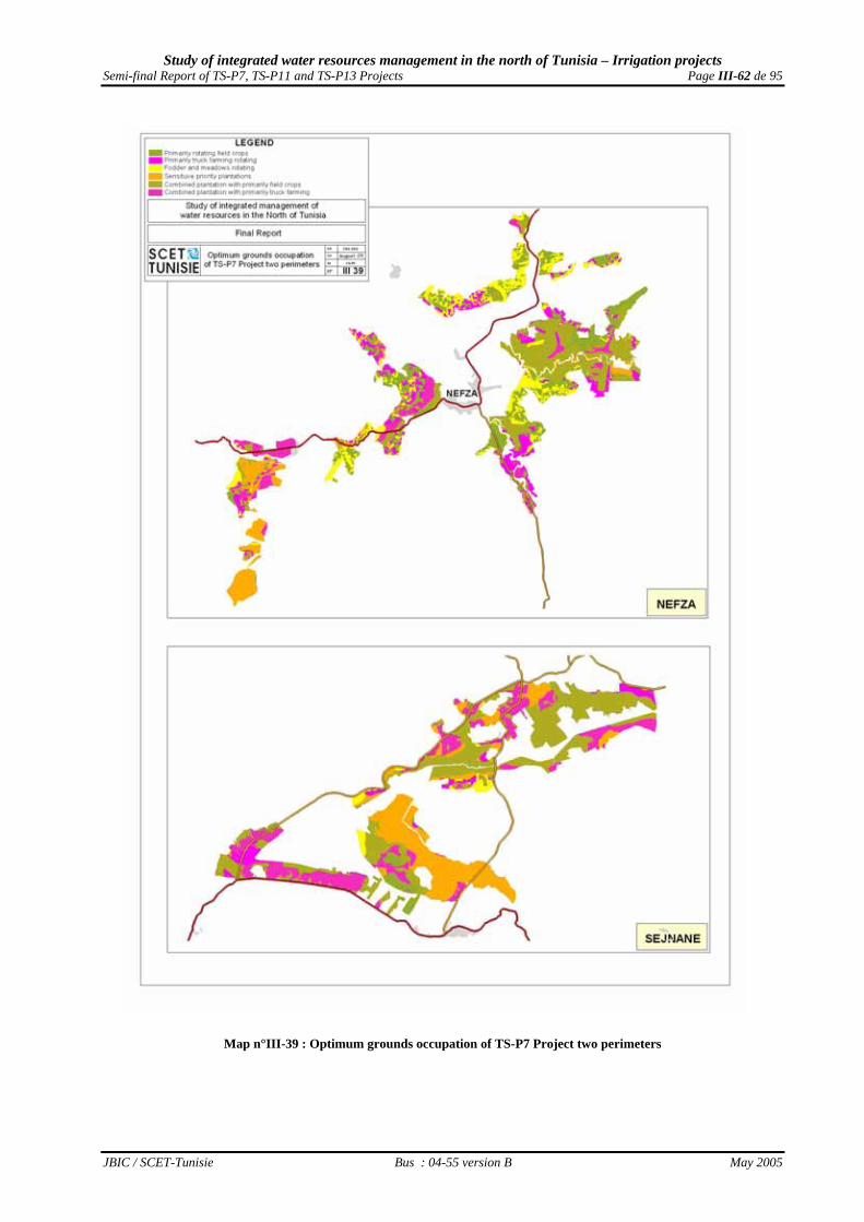
Study of integrated water resources management in the north of Tunisia – Irrigation projects Semi-final Report of TS-P7, TS-P11 and TS-P13 Projects Page III-62 de 95
JBIC / SCET-Tunisie Bus : 04-55 version B May 2005
Map n°III-39 : Optimum grounds occupation of TS-P7 Project two perimeters

Study of integrated water resources management in the north of Tunisia – Irrigation projects Semi-final Report of TS-P7, TS-P11 and TS-P13 Projects Page III-63 de 95
JBIC / SCET-Tunisie Bus : 04-55 version B May 2005
Map n° III-40 : Optimum grounds occupation of Goubellat perimeter

Study of integrated water resources management in the north of Tunisia – Irrigation projects Semi-final Report of TS-P7, TS-P11 and TS-P13 Projects Page III-64 de 95
JBIC / SCET-Tunisie Bus : 04-55 version B May 2005
A diversification of the sown cereals is noticed, to consider the variable physical potentialities which were mobilized by the Project, and the development of fruit plantations and cultivations for which the outlets are reliable (Tobacco) or conservation is easy (Garlic). In addition, the ground occupation increases from 135% (553 ha of summer cultivations on an equipped 1,575 ha of SAU ) to 141% (480 ha of summer cultivations on an equipped SAU of 1,164 ha ).
a.6) Ground occupation in Hammam Bourguiba perimeter = indicator n°2e From the same reasoning, the distribution of the estimated grounds occupation in Hamam Bourguiba perimeter is presented in Table n°III-9 below. Table n°III-9 : Distribution of the available vocations for the four irrigated production types in Hammam Bourguiba
Usable potentiality standard level Type of cultivation S1 S2 S3 S4 TOTAL
Sensitive arboriculture 0.0 42.9 48.6 0.0 0.0 Proportion (%) 0.0% 46.8% 53.2% 0.0% 0.0% Hardy arboriculture 0.0 0.0 69.3 25.4 0.0 Proportion (%) 0.0% 46.8% 53.2% 0.0% 0.0% Truck farming 0.0 0.0 60.7 33.6 0.0 Proportion (%) 0.0% 0.0% 64.4% 35.6% 0.0% Irrigated Field crops 82.6 0.0 193.6 3.7 0.0 Proportion (%) 28.7% 0.0% 67.3% 1.3% 0.0%
TOTAL 82.6 42.9 372.3 62.7 0.0 Proportion (%) 14.5% 7.5% 65.5% 11.0% 0.0%
From these data, and after having recorded the choices of cultivation expressed by the future beneficiariess, it could be recommended to the irrigators the installation of sensitive cultivations on the grounds of best vocation, and hardyer cultivations on the grounds of more marginal vocation, like presented in Map n°III-41 on page III-81. Compared to the initial predictions of the feasibility study established by CNEA in 1996, such a step leads to the appearance of sensitive modifications on the level of the expected grounds occupation. These modifications are indicated in Table n°III-10 on page III-65.

Study of integrated water resources management in the north of Tunisia – Irrigation projects Semi-final Report of TS-P7, TS-P11 and TS-P13 Projects Page III-65 de 95
JBIC / SCET-Tunisie Bus : 04-55 version B May 2005
Table n°III-10 : Variation of the estimated grounds occupation in Hammam Bourguiba perimeter Ground Occupation
Cultivation Evaluated
n 1996 (ha) Commendable in 2005 (ha)
Variations (%)
Walnut tree 13.9 21.5 + 54.7% Pear tree 19.0 35.0 + 84.2% Apple tree 21.2 35.0 + 65.1% Oil olive trees 26.4 34.2 + 29.5% Table olive trees 48.4 60.5 + 25.0% Wheat 201.1 50.0 - 75.1% Barley-grain 50.7 37.4 - 26.2% Triticale 30.0 new Leguminous plants 30.0 new Tobacco 60.0 60.0 unchanged Barley in green 61.2 40.0 - 34.6% Bersim 80.0 50.0 - 37.5% Tare-Oats hay 80.0 50.0 - 37.5% Fodder corn 70.0 abandonment Sorghum fodder 80.0 85.0 + 6.3% Late fall potato 31.5 new Carrot 15.7 new Turnip 15.7 new Green onion 15.7 new Broad bean in green 15.7 new Tomato 25.0 new Pepper 10.0 new Melon 15.0 new Water melon 5.0 new
One can notice the development of the fruit plantations, the diversification of the sown large-scale cultivations and the introduction of the truck farming considering the variable physical potentialities mobilized by the Project. In addition, the ground occupation rate remains stable at 135% (210 ha of summer cultivations on 602 ha of initially planned SAU against 200 ha of summer cultivations on 568 ha equipped SAU).
b) The redefinition of the objective outputs
b.1) The used methodology
b.1.1) Mode of cultivations distribution by vocation type It’s clear that the potential output of the major irrigated cultivations depends on the concerned cultivation s’ great type agronomic vocation of the morpho-pedological units which will be sown. Relying on the agronomic research observations - the popularization services should manage to obtain a cautious distribution of the potential irrigated cultivations proposed in function of the morpho-pedological units agronomic vocation available for this end – the sensitive species occupying in priority good vocation fields, and the hardyer ones the more marginal fields. b.1.2) Determination mode of the potential outputs According to the sensitivity or the hardiness of each cultivation, one will be able then to determine the expected outputs in each concerned vocation type, and the general average output of the speculation for each perimeter.

Study of integrated water resources management in the north of Tunisia – Irrigation projects Semi-final Report of TS-P7, TS-P11 and TS-P13 Projects Page III-66 de 95
JBIC / SCET-Tunisie Bus : 04-55 version B May 2005
b.2) Potential outputs in Nefza perimeters = indicator n°3a From the data of Table n° III-1 on page III-55 on the proposed occupation by cultivation great type for Nefza perimeter, we can now deduce a cautious distribution of each cultivation vocation by vocation in post- setting in water -situation b.2.1) Potential outputs of fruit productions in Nefza perimeter Based on these agronomic research observations, the popularization services should manage to obtain, for Nefza perimeter, in cruising year, the cautious distributions of the potential plantations between fruit species in function of the morpho-pedological units agronomic vocation available for this end, as proposed in Table n°III-11 below.
Table n°III-11 : Distribution of fruit plantations to realize by level of agronomic vocation in Nefza perimeter Used potentiality level S1 S2 S3 TOTAL
Sensitive arboriculture Pear tree 3.5 0.7 148.8 153.0
Apple tree 3.5 0.7 148.8 153.0 Citrus fruits 133.8 27.2 0.0 161.0
TOTAL 140.8 28.6 297.5 467.0 Proportion 30.2% 6.1% 63.7% 100.0%
Table n°III-12 below compares for Nefza perimeter the assumptions of fruit output of the 1996 feasibility study with the expected outputs, considering the real agronomic vocation of the 467 ha actually arranged by the Project and available for this purpose
Table n°III-12 : Estimated fruit outputs in Nefza according to the agronomic vocation (in T /ha) Fruit outputs Evaluated Commendable in 2005 according to physical potentialities Variations Type of plantation in 1996 S1 S2 S3 TOGETHER (%) Sensitive arboriculture
Pear tree 25.0 23.1 22.0 18.7 18.8 - 24.7% Apple tree 25.0 23.1 22.0 18.7 18.8 - 24.7%
Citrus fruits 18.0 21.0 20.0 17.0 20.8 + 15.7% It’s noticed that pear and apple trees - which will be essentially planted on grounds having irrigated sensitive arboriculture vocation of S3 type - when they are kept, the objective of their outputs decreases appreciably when compared to the very optimistic feasibility study proposals. The citrus fruits output objectives - which will be essentially planted on grounds having irrigated sensitive arboriculture vocation of S1 type - are slightly improved considering also the already acquired experience in that domain in Ouchtata. b.2.2) Potential outputs of the irrigated large-scale cultivations in Nefza perimeter While being based on these agronomic research observations, the popularization services should manage to obtain for Nefza perimeter the cautious distributions of the future various seeds species between the different irrigated large-scale cultivations in function of the morpho pedological units agronomic vocation available for this purpose as proposed in Table n°III-13 on page III-67.

Study of integrated water resources management in the north of Tunisia – Irrigation projects Semi-final Report of TS-P7, TS-P11 and TS-P13 Projects Page III-67 de 95
JBIC / SCET-Tunisie Bus : 04-55 version B May 2005
Table n°III-13 : Distribution of irrigated field crops seeding by agronomic vocation level in Nefza perimeter Used potentiality level S1 S2 S3 S4 S5 S6 TOTAL
Sensitive irrigated field crops Corns 96.5 37.3 16.2 150.0
Triticale 29.0 11.2 59.9 100.0 Leguminous plants 67.6 26.1 144.4 238.0
Tobacco 144.8 44.7 53.5 243.0 Bersim 48.3 18.6 157.1 26.0 250.0
hardy irrigated field crops Barley-grain 20.0 71.5 0.5 33.0 125.0
Oats 20.0 71.5 0.5 33.0 125.0 Barley in green 10.8 5.9 233.3 250.0
Tare-oats hay 48.3 18.6 131.9 51.2 250.0 Fodder sorghum 29.0 16.8 182.8 70.0 1.5 300.0
TOTAL in winter 289.5 111.8 549.4 231.0 6.9 299.3 1 731.0 Proportion 16.7% 6.5% 31.7% 13.3% 0.4% 17.3%
Table n°III-14 below compares for Nefza perimeter the output assumptions of the irrigated large-scale cultivations of the 1996 feasibility study with the hoped outputs by considering the real agronomic vocation of the 1,731 ha actually arranged by the Project and available for this purpose
Table n°III-14 : Estimated outputs irrigated field crops in Nefza (in T /ha) Outputs Evaluated Commendable in 2005 according to mobilized physical potentialities' Variations
Type of speculation in 1996 S1 S2 S3 S4 S5 S6 TOGETHER (%) Sensitive irrigated field crops
Wheat 5.5 6.3 6.0 5.4 6.1 +11.4% Triticale 6.1 5.8 5.2 5.5 new
Leguminous plants 2.0 3.7 3.5 3.2 3.3 +66.9% Tobacco 2.0 2.6 2.5 2.3 1.6 2.3 new
Bersim 50.0 73.5 70.0 63.0 45.5 63.7 + 27.5% Hardy irrigated field crops
Barley-grain 5.0 4.1 3.2 2.2 3.8 new Oats 3.8 3.1 2.4 1.7 2.8 new
Barley in green 45.0 31.2 24.0 16.8 17.6 - 60.9% Hay of Vetch oat 6.0 7.7 7.5 7.1 5.9 7.0 + 16.1%
Fodder corn 40.0 6.1 abandon Fodder sorghum 61.8 60.0 56.4 46.8 36.0 54.8 new
It is noticed that the objective outputs of the large-scale cultivations suggested in the feasibility study were , rather pessimistic for the sensitive cultivations and the hay of vetch oat which we must envisage their re-evaluation, and very optimistic for the barlmey in green which we must consider their reduction. b.2.3) Potential outputs of the truck farming in Nefza perimeter While being based on these agronomic research observations, the popularization services should manage to obtain for Nefza perimeter the cautious distributions of future seeds between the various truck farming species according to the morpho-pedological units agricultural vocation available for this purpose as proposed in Table n°III-15 on page III-68.
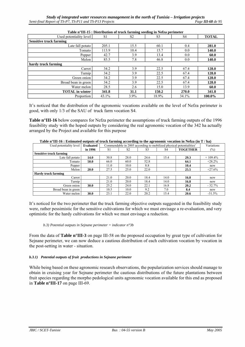
Study of integrated water resources management in the north of Tunisia – Irrigation projects Semi-final Report of TS-P7, TS-P11 and TS-P13 Projects Page III-68 de 95
JBIC / SCET-Tunisie Bus : 04-55 version B May 2005
Table n°III-15 : Distribution of truck farming seeding in Nefza perimeter Used potentiality level S1 S2 S3 S4 TOTAL
Sensitive truck farming Late fall potato 205.1 15.5 60.1 0.4 281.0
Tomato 113.9 10.4 15.7 0.0 140.0 Pepper 42.7 3.9 13.4 0.0 60.0 Melon 85.5 7.8 46.8 0.0 140.0
hardy truck farming Carrot 34.2 3.9 22.5 67.4 128.0 Turnip 34.2 3.9 22.5 67.4 128.0
Green onion 34.2 3.9 22.5 67.4 128.0 Broad bean in green 34.2 3.9 22.5 67.4 128.0
Water melon 28.5 2.6 15.0 13.9 60.0 TOTAL in winter 341.8 31.1 150.2 270.0 341.8
Proportion 43.1% 3.9% 18.9% 34.1% 100.0% It’s noticed that the distribution of the agronomic vocations available on the level of Nefza perimeter is good, with only 1/3 of the SAU of truck farm vocation S4. Table n°III-16 below compares for Nefza perimeter the assumptions of truck farming outputs of the 1996 feasibility study with the hoped outputs by considering the real agronomic vocation of the 342 ha actually arranged by the Project and available for this purpose
Table n°III-16 : Estimated outputs of truck farming according to the agronomic vocation in Nefza (in T / ha) Used potentiality level Evaluated Commendable in 2005 according to mobilized physical potentialities' Variations
in 1996 S1 S2 S3 S4 TOGETHER (%) Sensitive truck farming
Late fall potato 14.0 30.8 28.0 24.6 15.4 29.3 + 109.4% Tomato 50.0 66.0 60.0 52.8 64.1 +28.2% Pepper 11.0 10.0 8.8 10.4 new Melon 20.0 27.5 25.0 22.0 25.5 +27.6%
Hardy truck farming Carrot 21.0 20.0 18.4 14.0 16.8 new Turnip 21.0 20.0 18.4 14.0 16.8 new
Green onion 30.0 25.2 24.0 22.1 16.8 20.2 - 32.7% Broad bean in green 10.5 10.0 9.2 7.0 8.4 new
Water melon 30.0 23.1 22.0 20.2 15.4 20.6 -31.5% It’s noticed for the two perimeter that the truck farming objective outputs suggested in the feasibility study were, rather pessimistic for the sensitive cultivations for which we must envisage a re-evaluation, and very optimistic for the hardy cultivations for which we must envisage a reduction.
b.3) Potential outputs in Sejnane perimeter = indicator n°3b From the data of Table n°III-3 on page III-58 on the proposed occupation by great type of cultivation for Sejnane perimeter, we can now deduce a cautious distribution of each cultivation vocation by vocation in the post-setting in water - situation. b.3.1) Potential outputs of fruit productions in Sejnane perimeter While being based on these agronomic research observations, the popularization services should manage to obtain in cruising year for Sejnane perimeter the cautious distributions of the future plantations between fruit species regarding the morpho pedological units agronomic vocation available for this end as proposed in Table n°III-17 on page III-69.

Study of integrated water resources management in the north of Tunisia – Irrigation projects Semi-final Report of TS-P7, TS-P11 and TS-P13 Projects Page III-69 de 95
JBIC / SCET-Tunisie Bus : 04-55 version B May 2005
Table n°III-17 : Distribution of fruit plantations to realize by agronomic vocation level in Sejnane perimeter Used potentiality level S1 S2 S3 TOTAL Sensitive arboriculture
Pear tree 91.6 80.6 19.8 192.0 Apple tree 91.6 80.6 19.8 192.0
Citrus fruits 125.0 0.0 125.0 Hardy arboriculture
Pomegranate 450.0 450.0 TOTAL 308.2 161.1 489.6 959.0
Proportion 32.1% 16.8% 51.0% 100.0% Table n°III-18 below compares for Sejnane perimetre the fruit output assumptions of the 1996 feasibility study with the hoped outputs, considering the real agronomic vocation of the 959 ha actually arranged by the Project and available for this purpose
Table n°III-18 : Estimated fruit outputs in Sejnane (in T / ha) Fruit outputs Evaluated Commendable in 2005 according to mobilized physical potentialities' Variations
Type of plantation in 1996 S1 S2 S3 TOGETHER (%) Sensitive arboriculture
Pear tree 25.0 17.9 17.0 14.5 17.1 -31.5% Apple tree 25.0 17.9 17.0 14.5 17.1 -31.5%
Citrus fruits 18.0 16.8 16.8 -6.7% Hardy arboriculture
Pomegranate 16.6 16.6 new It is noticed that the three fruit cultivations outputs decreased appreciably when compared to the very optimistic proposals of the feasibility study, mainly, pear and apple trees which will be essentially planted in the irrigated sensitive arboriculture grounds of vocation type S1 and S2, but also The citrus fruits entirely planted in the irrigated sensitive arboriculture grounds of vocation type S1. b.3.2) Potential outputs of the irrigated large-scale cultivations in Sejnane perimeter While being based on these agronomic research observations, the popularization services should manage to obtain for Sejnane perimeter the cautious distributions of the future seeds between the various large-scale cultivations regarding the morpho pedological units agronomic vocation available for this end as proposed in Table n°III-19 below. .
Table n°III-19 : Distribution of the irrigated field crops seeding by agronomic vocation level in Sejnane Used level potentiality S1 S2 S3 S4 TOTAL
Sensitive irrigated field crops Corns 264.7 21.3 28.0 314.0
Triticale 147.0 10.7 2.3 160.0 Leguminous plants 250.0 10.7 4.3 265.0
Tobacco 327.9 19.2 3.0 350.0 Bersim 176.5 12.8 10.8 200.0 400.0
Hardy irrigated field crops Barley-grain 2.9 32.3 35.2
Oats 9.7 40.3 50.0 Barley in green 15.0 285.0 300.0
Tare-oats hay 44.1 8.6 40.3 307.0 400.0 Fodder sorghum 264.7 32.0 23.3 280 600.0
TOTAL in winter 882.3 64.0 113.3 864.6 1 924.2 Proportion 45.9% 3.3% 5.9% 44.9% 100.0%
Table n°III-20 on page III-70 compares for Sejnane perimeter the irrigated large-scale cultivations output assumptions of the 1996 feasibility study with the hoped outputs by considering the real agronomic vocation of the 1,924 ha actually arranged by the Project and available for this purpose.

Study of integrated water resources management in the north of Tunisia – Irrigation projects Semi-final Report of TS-P7, TS-P11 and TS-P13 Projects Page III-70 de 95
JBIC / SCET-Tunisie Bus : 04-55 version B May 2005
Table n°III-20 : Estimated outputs of irrigated field crops in Sejnane (in T /ha) Outputs Evaluated Commendable in 2005 according to mobilized physical potentialities' Variations
Type of speculation in 1996 S1 S2 S3 S4 TOGETHER (%) Sensitive irrigated field crops
Wheat 5.5 6.3 6.0 5.4 6.2 + 12.7% Triticale 6.0 5.7 5.1 6.0 nouveau
Leguminous plants 2.0 3.4 3.2 2.9 3.3 + 67.3% Tobacco 2.0 2.6 2.5 2.6 +30.7%
Bersim 50.0 68.3 65.0 58.5 42.3 54.9 + 9.8% Hardy irrigated field crops
Barley-grain 5.0 4.0 4.1 nouveau Oats 3.8 3.0 3.1 nouveau
Barley in green 45.0 37.6 30.0 30.4 - 32.5% Hay of Vetch oat 6.0 7.7 7.5 7.1 5.6 6.0 + 0.7%
Fodder corn 40.0 0.0 abandon Fodder sorghum 61.8 60.0 56.4 45.0 51.3 nouveau
It is noticed that the objective outputs of large-scale cultivations suggested in the feasibility study were , rather pessimistic for the sensitive cultivations and we must consider their re-evaluation, and very optimistic for the barley in green that we must consider their reduction. b.3.3) Potential outputs of truck farming in Sejnane perimeter While being based on these agronomic research observations, the popularization services should manage to obtain for Sejnane perimeter the cautious distributions of future seeds between the various truck farming species according to the morpho-pedological units agronomic vocation available for this purpose as proposed in Table n°III-21 below
Table n°III-21 : Distribution of truck farming seeds in Sejnane Used potentiality level S1 S2 S3 S4 TOTAL
Sensitive truck farming Late fall potato 79.9 22.7 86.9 25.5 215.0
Tomato 44.4 18.2 60.4 0.0 123.0 Pepper 19.0 7.6 18.4 0.0 45.0 Melon 33.3 11.4 30.3 0.0 75.0
Hardy truck farming Carrot 13.3 5.7 38.6 65.4 123.0 Turnip 13.3 5.7 38.6 65.4 123.0
Green onion 13.3 5.7 38.6 65.4 123.0 Broad bean in green 13.3 5.7 38.6 65.4 123.0
Water melon 6.7 5.7 10.7 40.0 63.0 TOTAL in winter 133.2 45.5 241.3 287.0 707.0
Proportion 18.8% 6.4% 34.1% 40.6% 100.0% It is noticed that the distribution of the agronomic vocations mobilized in Sejnane perimeter is average, with in particular almost the half of the truck farming vocation SAU S4 in Sejnane. Table n°III-22 of page III-71 compares for Sejnane perimeter the assumptions of truck farming outputs of the 1997 Detailed Study with the hoped outputs by considering the real agronomic vocation of the 707 ha actually arranged by the Project and available for this purpose
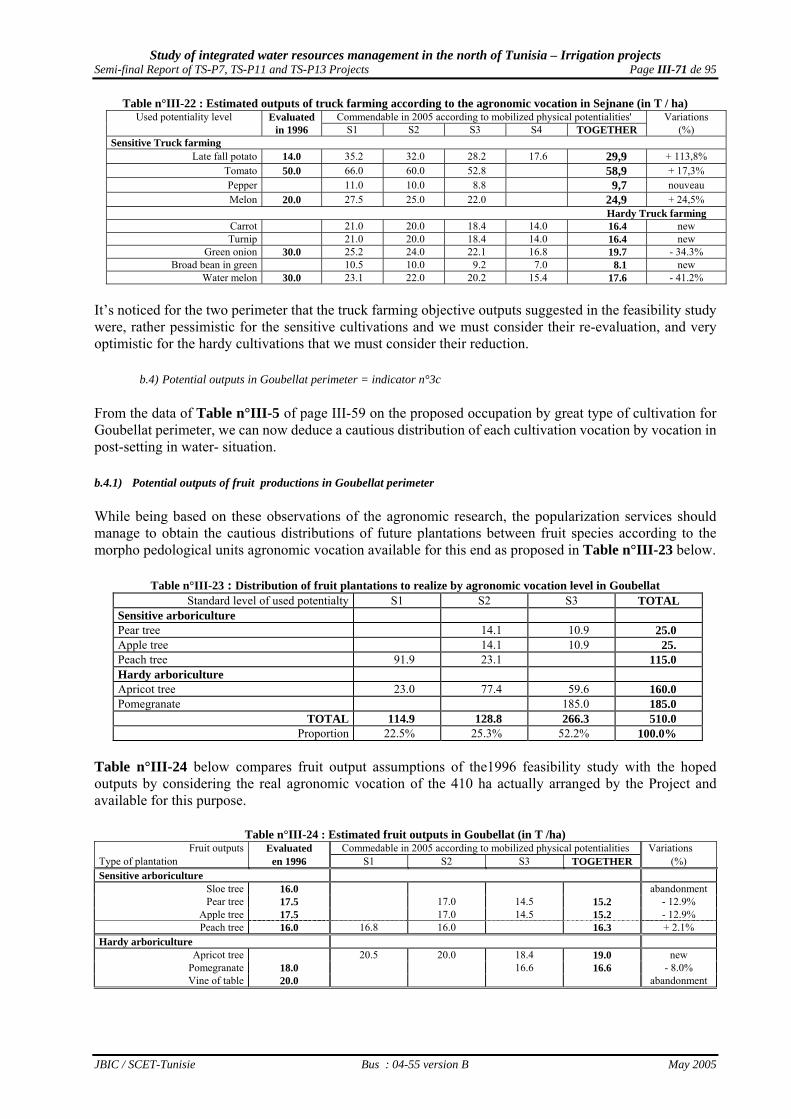
Study of integrated water resources management in the north of Tunisia – Irrigation projects Semi-final Report of TS-P7, TS-P11 and TS-P13 Projects Page III-71 de 95
JBIC / SCET-Tunisie Bus : 04-55 version B May 2005
Table n°III-22 : Estimated outputs of truck farming according to the agronomic vocation in Sejnane (in T / ha) Used potentiality level Evaluated Commendable in 2005 according to mobilized physical potentialities' Variations
in 1996 S1 S2 S3 S4 TOGETHER (%) Sensitive Truck farming
Late fall potato 14.0 35.2 32.0 28.2 17.6 29,9 + 113,8% Tomato 50.0 66.0 60.0 52.8 58,9 + 17,3% Pepper 11.0 10.0 8.8 9,7 nouveau Melon 20.0 27.5 25.0 22.0 24,9 + 24,5%
Hardy Truck farming Carrot 21.0 20.0 18.4 14.0 16.4 new Turnip 21.0 20.0 18.4 14.0 16.4 new
Green onion 30.0 25.2 24.0 22.1 16.8 19.7 - 34.3% Broad bean in green 10.5 10.0 9.2 7.0 8.1 new
Water melon 30.0 23.1 22.0 20.2 15.4 17.6 - 41.2% It’s noticed for the two perimeter that the truck farming objective outputs suggested in the feasibility study were, rather pessimistic for the sensitive cultivations and we must consider their re-evaluation, and very optimistic for the hardy cultivations that we must consider their reduction.
b.4) Potential outputs in Goubellat perimeter = indicator n°3c From the data of Table n°III-5 of page III-59 on the proposed occupation by great type of cultivation for Goubellat perimeter, we can now deduce a cautious distribution of each cultivation vocation by vocation in post-setting in water- situation. b.4.1) Potential outputs of fruit productions in Goubellat perimeter While being based on these observations of the agronomic research, the popularization services should manage to obtain the cautious distributions of future plantations between fruit species according to the morpho pedological units agronomic vocation available for this end as proposed in Table n°III-23 below.
Table n°III-23 : Distribution of fruit plantations to realize by agronomic vocation level in Goubellat Standard level of used potentialty S1 S2 S3 TOTAL
Sensitive arboriculture Pear tree 14.1 10.9 25.0 Apple tree 14.1 10.9 25. Peach tree 91.9 23.1 115.0 Hardy arboriculture Apricot tree 23.0 77.4 59.6 160.0 Pomegranate 185.0 185.0
TOTAL 114.9 128.8 266.3 510.0 Proportion 22.5% 25.3% 52.2% 100.0%
Table n°III-24 below compares fruit output assumptions of the1996 feasibility study with the hoped outputs by considering the real agronomic vocation of the 410 ha actually arranged by the Project and available for this purpose.
Table n°III-24 : Estimated fruit outputs in Goubellat (in T /ha) Fruit outputs Evaluated Commedable in 2005 according to mobilized physical potentialities Variations
Type of plantation en 1996 S1 S2 S3 TOGETHER (%) Sensitive arboriculture
Sloe tree 16.0 abandonmentPear tree 17.5 17.0 14.5 15.2 - 12.9%
Apple tree 17.5 17.0 14.5 15.2 - 12.9% Peach tree 16.0 16.8 16.0 16.3 + 2.1%
Hardy arboriculture Apricot tree 20.5 20.0 18.4 19.0 new
Pomegranate 18.0 16.6 16.6 - 8.0% Vine of table 20.0 abandonment

Study of integrated water resources management in the north of Tunisia – Irrigation projects Semi-final Report of TS-P7, TS-P11 and TS-P13 Projects Page III-72 de 95
JBIC / SCET-Tunisie Bus : 04-55 version B May 2005
It is noticed that the objective outputs of the two preserved fruit speculations which were seeded in grounds of vocation S3 decreased appreciably when compared to the very optimistic proposals of the feasibility study. b.4.2) Potential outputs of irrigated large-scale cultivations in Goubellat perimeter While being based on these observations of the agronomic research, the popularization services should manage to obtain the cautious distributions of future seeds of the various irrigated large-scale cultivations species according to the morpho pedological units agronomic vocation available for this end as proposed in Table n°III-25 below.
Table n°III-25 : Distribution of irrigated field crops seeds by agronomic vocation level in Goubellat Standard level of used potentiality S1 S2 S3 S4 TOTAL
Sensitive irrigated field crops Wheat 297.0 0.4 32.6 330.0 Triticale 91.0 39.0 130.0 Leguminous plants 234.6 41.4 276.0 Bersim 160.0 0.1 39.9 200.0 Hardy irrigated field crops Barley-grain 2.0 21.6 26.1 50.0 Oats 8.0 72.0 80.0 Barley in green 6.0 24.0 90.0 120.0 Tare-oats hay 140.0 0.2 59.8 200.0 Tare-oats ensilage 130.0 0.2 69.8 200.0 Sorghum fodder 154.0 0.2 65.8 220.0
TOTAL 1 068.6 0.9 400.1 116.1 1 586.0 Proportion 67.4% 0.1% 25.2% 7.3% 100.0%
Table n°III-26 below below compares the irrigated large-scale cultivations output assumptions of the 1996 feasibility study with the hoped outputs by considering the real agronomic vocation of the 1,366 ha actually arranged by the Project and available for this purpose
Table n°III-26 : Estimated outputs of the irrigated field crops in Goubellat (in T / ha)
Outputs Evaluated Commendable in 2005 according to mobilized physical potentialities Variations Type of cultivations en 1996 S1 S2 S3 S4 TOGETHER (%) Sensitive irrigated field crops Wheat 6.5 6.3 6.0 5.4 6.2 - 4.5% Triticale 6.0 5.1 5.7 new Leguminous plants 3.5 3.4 3.2 2.9 3.3 - 6.1% Bersim 70.0 68.3 65.0 58.5 66.3 - 5.3% Hardy irrigated field crops Barley-grain 6.0 5.5 5.0 4.0 4.5 - 25.5% Oat 4.1 3.8 3.8 new Barley in green 41.2 37.6 30.0 32.1 new Tare oat hay 8.0 7.7 7.5 7.1 7.5 - 6.0% Vesce-Avoine ensilage 40.0 39.1 38.0 35.7 37.9 - 5.1% Fodder sorghum 70.0 61.8 60.0 56.4 60.3 - 13.8% Luzerne 60.0 Abandonment
It is noticed that the objective outputs of the large-scale cultivations suggested in the feasibility study were very optimistic, and we can only consider their reduction. b.4.3) Potential outputs of truck farming in Goubellat perimeter While being based on the observations of the agronomic research, the popularization services should manage to obtain the cautious distributions of future seeds between the various truck farming species as proposed in Table n°III-27 on page III-73 according to the morpho pedological units agronomic vocation available for this purpose.

Study of integrated water resources management in the north of Tunisia – Irrigation projects Semi-final Report of TS-P7, TS-P11 and TS-P13 Projects Page III-73 de 95
JBIC / SCET-Tunisie Bus : 04-55 version B May 2005
Table n°III-27 : Distribution of truck farming seeds by agronomic vocation level in Goubellat Standard level of used potentiality S1 S2 S3 S4 TOTAL
Sensitive truck farming cultivations Late fall Potato 263.7 101.3 365.0 Tomato 72.1 57.9 130.0 Pepper 37.0 28.0 65.0 Melon 86.1 13.9 100.0 Hardy truck farming cultivations Carrot 9.1 65.2 16.7 91.0 Turnip 9.1 65.2 16.7 91.0 Green onion 9.1 65.2 16.7 91.0 Broad bean in green 18.2 64.4 8.4 91.0 Water melon 15.7 12.5 21.7 50.0
TOTAL in winter 0.0 309.2 361.4 58.5 729.0 Proportion 0.0% 42.4% 49.6% 8.0% 100.0%
Table n°III-28 below compares the truck farming outputs assumptions of the 1996 feasibility study with the hoped outputs by considering the real agronomic vocation of the 635 ha actually arranged by the Project and available for this purpose
Table n°III-28 : Estimated truck farming outputs in Goubellat (in T /ha) Truck farming outputs Evaluated Commendable in 2005 according to mobilized physical potentialities Variations
Truck farming speculations in 1996 S1 S2 S3 S3 TOGETHER (%) Sensitive cultivations
Late fall Potato 30.0 32.0 28.2 30.9 + 3.1% Tomato 40.0 60.0 52.8 56.9 + 42.3% Pepper 10.0 8.8 9.5 new Melon 30.0 25.0 22.0 24.6 - 18.1%
Hardy cultivations Carrot 25.0 20.0 18.4 14.0 17.8 - 29.0% Turnip 25.0 20.0 18.4 14.0 17.8 - 29.0%
Green onion 25.0 24.0 22.1 16.8 21.3 - 14.8% Broad bean in green 12.0 10.0 9.2 7.0 9.2 - 23.7%
Water melon 30.0 22.0 20.2 15.4 18.7 - 37.7%
It’s noticed that the truck farming cultivations objective outputs suggested in the detailed study were again , very optimistic and that we must consider their reduction, except for tomato whose obtained results these last years under drop by drop irrigation system are much higher than the objective output suggested in 1996.
b.5) Potential outputs in Fernana perimeter = indicator n°3d Frm the data of Table n°III-7 of page III-61 on the proposed occupation by great type cultivation for Fernana perimeter, we can now deduce a cautious distribution of each cultivation vocation by vocation in a post-setting in water - situation. b.5.1) Potential outputs of fruit productions in Fernana perimeter Based on the agronomic research observations, the popularization services should manage to obtain in cruising year for Fernana perimeter a cautious distribution of future plantations between fruit species according to the morpho pedological units agronomic vocation available for this purpose as proposed in Table n°III-29 on page III-74.

Study of integrated water resources management in the north of Tunisia – Irrigation projects Semi-final Report of TS-P7, TS-P11 and TS-P13 Projects Page III-74 de 95
JBIC / SCET-Tunisie Bus : 04-55 version B May 2005
Table n°III-29 : Distribution of the fruit plantations to realize by agronomic vocation level in Fernana Standard level of used potentiality S1 S2 S3 S4 TOTAL
Sensitive arboriculture Walnut tree 23.0 17.0 40.0 Pear tree 0.4 46.1 3.5 50.0 Apple tree 0.4 46.1 3.5 50.0 Citrus fruits 15.1 37.4 52.5 Hardy arboriculture Oil olive tree 53.4 24.1 77.5 Table olive tree 2 .2 6.8 104.9 6.0 120.0
TOTAL 18.1 159.4 182.4 30.1 390.0 Proportion 4.6% 40.9% 46.8% 7.7% 100.0%
Table n°III-30 below compares for Fernana perimeter the fruit output assumptions of the 1996 feasibility study with the hoped outputs, considering the real agronomic vocation of the 300 ha actually arranged by the Project and available for this purpose
Table n°III-30 : Estimated fruit outputs in Fernana (in T /ha) Outputs Evaluated Commendable in 2005 according to mobilized physical potentialities Variations
Type of speculation in 1996 S1 S2 S3 S4 TOGETHER (%) Sensitive arboriculture
Walnut tree 0.40 0.40 0.34 0.37 - 6.4% Pear tree 20.0 21.0 20.0 17.0 19.8 - 1.0%
Apple tree 20.0 21.0 20.0 17.0 19.8 - 1.0% Citrus fruits 20.0 18.9 18.0 18.3 - 8.7%
Hardy arboriculture Oil olive tree 2.5 2.8 2.3 2.6 + 5.2% Table olivier 7.0 7.7 6.9 5.9 6.9 - 1.5%
It’s noticed that the objective outputs of the six preserved fruit cultivations decreased slightly compared to the quite optimistic proposals of the feasibility study, in particular the Walnut tree planted essentially on grounds of vocation S3. The output objectives for Citrus fruits consider Fernana plain future irrigators lack of experience in this field. b.5.2) Potential outputs of irrigated field crops in Fernana perimeter While being based on the agronomic research observations, the popularization services should manage to obtain for Fernana perimeter the cautious distribution of future seeds between the irrigated large-scale cultivations various species according to the morpho pedological units agronomic vocation available for this purpose as proposed in Table n°III-31 below.
Table n°III-31 : Distribution of irrigated field crops by agronomic vocation level in Fernana Standard level of used potentiality S1 S2 S3 S4 S5 S6 TOTAL Sensitive irrigated field crops Wheats 71.6 13.0 0.4 85.0 Triticale 23.9 5.2 10.9 15.0 Leguminous plants 35.8 17.3 6.9 15.0 Tobacco 59.7 20.8 8.5 40.0 Bersim 59.7 13.0 1.9 5.5 60.0 Hardy irrigated field crops Barley-grain 2.7 11.0 1.3 89.0 Oats 9.6 11.0 1.0 60.0 Barley in green 47.0 11.0 2.0 80.0 Tare-oats hay 47.7 3.5 3.3 5.5 60.0 Fodder sorghum 59.7 20.8 22.0 17.5 120.0
TOTAL in winter 238.7 52.0 76.2 43.8 0.0 4.3 504.0 Proportion 47.4% 10.3% 15.1% 8.7% 0.0% 0.9% 100.0%
Table n°III-32 of page III-75 compares for Fernana perimeter the irrigated large-scale cultivations output assumptions of 1996 feasibility study with the hoped outputs by considering the real agronomic vocation of the 778 ha actually arranged by the Project and available for this purpose
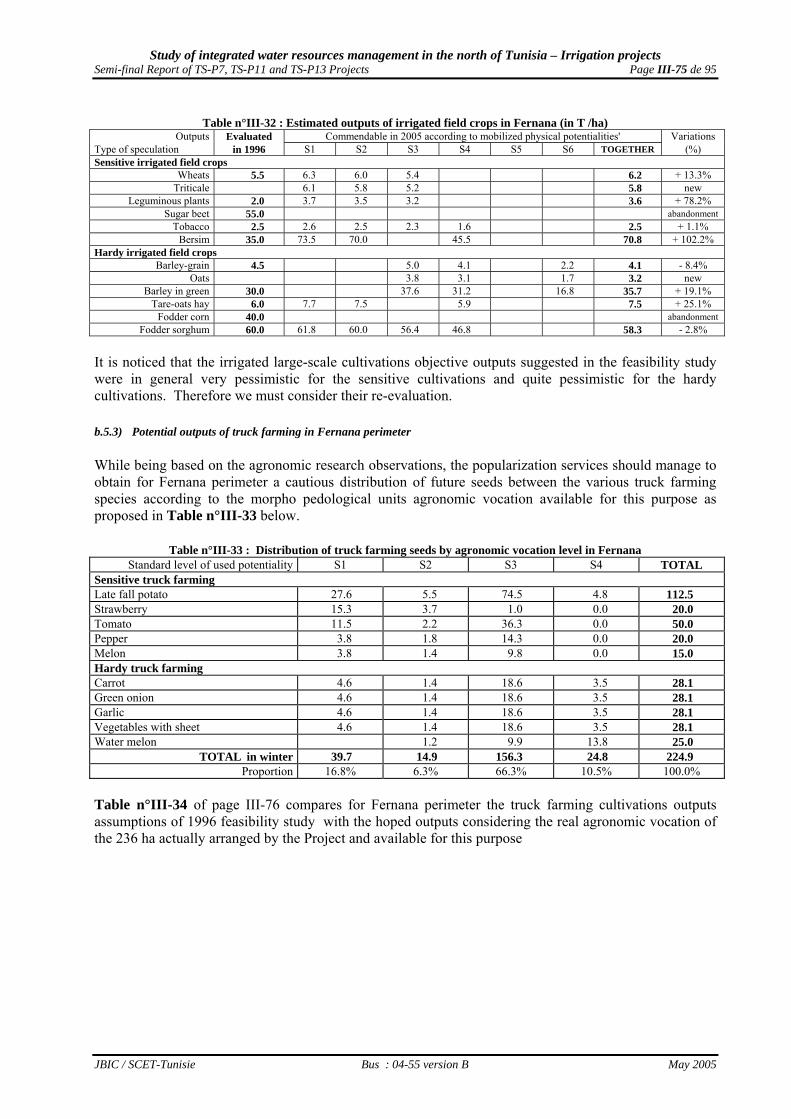
Study of integrated water resources management in the north of Tunisia – Irrigation projects Semi-final Report of TS-P7, TS-P11 and TS-P13 Projects Page III-75 de 95
JBIC / SCET-Tunisie Bus : 04-55 version B May 2005
Table n°III-32 : Estimated outputs of irrigated field crops in Fernana (in T /ha)
Outputs Evaluated Commendable in 2005 according to mobilized physical potentialities' Variations Type of speculation in 1996 S1 S2 S3 S4 S5 S6 TOGETHER (%) Sensitive irrigated field crops
Wheats 5.5 6.3 6.0 5.4 6.2 + 13.3% Triticale 6.1 5.8 5.2 5.8 new
Leguminous plants 2.0 3.7 3.5 3.2 3.6 + 78.2% Sugar beet 55.0 abandonment
Tobacco 2.5 2.6 2.5 2.3 1.6 2.5 + 1.1% Bersim 35.0 73.5 70.0 45.5 70.8 + 102.2%
Hardy irrigated field crops Barley-grain 4.5 5.0 4.1 2.2 4.1 - 8.4%
Oats 3.8 3.1 1.7 3.2 new Barley in green 30.0 37.6 31.2 16.8 35.7 + 19.1%
Tare-oats hay 6.0 7.7 7.5 5.9 7.5 + 25.1% Fodder corn 40.0 abandonment
Fodder sorghum 60.0 61.8 60.0 56.4 46.8 58.3 - 2.8% It is noticed that the irrigated large-scale cultivations objective outputs suggested in the feasibility study were in general very pessimistic for the sensitive cultivations and quite pessimistic for the hardy cultivations. Therefore we must consider their re-evaluation. b.5.3) Potential outputs of truck farming in Fernana perimeter While being based on the agronomic research observations, the popularization services should manage to obtain for Fernana perimeter a cautious distribution of future seeds between the various truck farming species according to the morpho pedological units agronomic vocation available for this purpose as proposed in Table n°III-33 below.
Table n°III-33 : Distribution of truck farming seeds by agronomic vocation level in Fernana Standard level of used potentiality S1 S2 S3 S4 TOTAL
Sensitive truck farming Late fall potato 27.6 5.5 74.5 4.8 112.5 Strawberry 15.3 3.7 1.0 0.0 20.0 Tomato 11.5 2.2 36.3 0.0 50.0 Pepper 3.8 1.8 14.3 0.0 20.0 Melon 3.8 1.4 9.8 0.0 15.0 Hardy truck farming Carrot 4.6 1.4 18.6 3.5 28.1 Green onion 4.6 1.4 18.6 3.5 28.1 Garlic 4.6 1.4 18.6 3.5 28.1 Vegetables with sheet 4.6 1.4 18.6 3.5 28.1 Water melon 1.2 9.9 13.8 25.0
TOTAL in winter 39.7 14.9 156.3 24.8 224.9 Proportion 16.8% 6.3% 66.3% 10.5% 100.0%
Table n°III-34 of page III-76 compares for Fernana perimeter the truck farming cultivations outputs assumptions of 1996 feasibility study with the hoped outputs considering the real agronomic vocation of the 236 ha actually arranged by the Project and available for this purpose
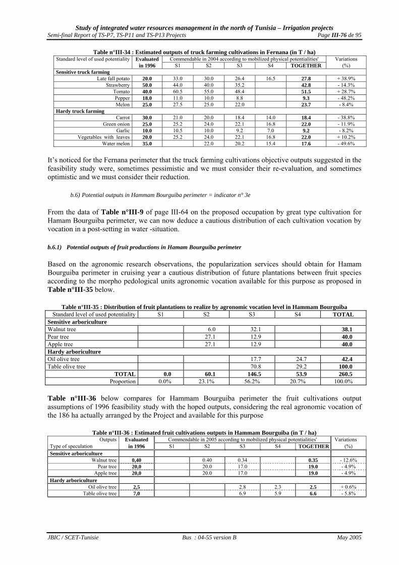
Study of integrated water resources management in the north of Tunisia – Irrigation projects Semi-final Report of TS-P7, TS-P11 and TS-P13 Projects Page III-76 de 95
JBIC / SCET-Tunisie Bus : 04-55 version B May 2005
Table n°III-34 : Estimated outputs of truck farming cultivations in Fernana (in T / ha) Standard level of used potentiality Evaluated Commendable in 2004 according to mobilized physical potentialities' Variations
in 1996 S1 S2 S3 S4 TOGETHER (%) Sensitive truck farming
Late fall potato 20.0 33.0 30.0 26.4 16.5 27.8 + 38.9% Strawberry 50.0 44.0 40.0 35.2 42.8 - 14.3%
Tomato 40.0 60.5 55.0 48.4 51.5 + 28.7% Pepper 18.0 11.0 10.0 8.8 9.3 - 48.2% Melon 25.0 27.5 25.0 22.0 23.7 - 8.4%
Hardy truck farming Carrot 30.0 21.0 20.0 18.4 14.0 18.4 - 38.8%
Green onion 25.0 25.2 24.0 22.1 16.8 22.0 - 11.9% Garlic 10.0 10.5 10.0 9.2 7.0 9.2 - 8.2%
Vegetables with leaves 20.0 25.2 24.0 22.1 16.8 22.0 + 10.2% Water melon 35.0 22.0 20.2 15.4 17.6 - 49.6%
It’s noticed for the Fernana perimeter that the truck farming cultivations objective outputs suggested in the feasibility study were, sometimes pessimistic and we must consider their re-evaluation, and sometimes optimistic and we must consider their reduction.
b.6) Potential outputs in Hammam Bourguiba perimeter = indicator n° 3e From the data of Table n°III-9 of page III-64 on the proposed occupation by great type cultivation for Hamam Bourguiba perimeter, we can now deduce a cautious distribution of each cultivation vocation by vocation in a post-setting in water -situation. b.6.1) Potential outputs of fruit productions in Hamam Bourguiba perimeter Based on the agronomic research observations, the popularization services should obtain for Hamam Bourguiba perimeter in cruising year a cautious distribution of future plantations between fruit species according to the morpho pedological units agronomic vocation available for this purpose as proposed in Table n°III-35 below.
Table n°III-35 : Distribution of fruit plantations to realize by agronomic vocation level in Hammam Bourguiba Standard level of used potentiality S1 S2 S3 S4 TOTAL
Sensitive arboriculture Walnut tree 6.0 32.1 38.1 Pear tree 27.1 12.9 40.0 Apple tree 27.1 12.9 40.0 Hardy arboriculture Oil olive tree 17.7 24.7 42.4 Table olive tree 70.8 29.2 100.0
TOTAL 0.0 60.1 146.5 53.9 260.5 Proportion 0.0% 23.1% 56.2% 20.7% 100.0%
Table n°III-36 below compares for Hammam Bourguiba perimeter the fruit cultivations output assumptions of 1996 feasibility study with the hoped outputs, considering the real agronomic vocation of the 186 ha actually arranged by the Project and available for this purpose
Table n°III-36 : Estimated fruit cultivations outputs in Hammam Bourguiba (in T / ha) Outputs Evaluated Commendable in 2005 according to mobilized physical potentialities' Variations
Type of speculation in 1996 S1 S2 S3 S4 TOGETHER (%) Sensitive arboriculture
Walnut tree 0,40 0.40 0.34 0.35 - 12.6% Pear tree 20,0 20.0 17.0 19.0 - 4.9%
Apple tree 20,0 20.0 17.0 19.0 - 4.9% Hardy arboriculture
Oil olive tree 2,5 2.8 2.3 2.5 + 0.6% Table olive tree 7,0 6.9 5.9 6.6 - 5.8%

Study of integrated water resources management in the north of Tunisia – Irrigation projects Semi-final Report of TS-P7, TS-P11 and TS-P13 Projects Page III-77 de 95
JBIC / SCET-Tunisie Bus : 04-55 version B May 2005
It’s noticed that, except the Oil olive tree, the 4 other kept fruit cultivations objective outputs decreased appreciably compared to the optimistic proposals of the feasibility study, in particular the Walnut tree planted essentially on grounds of vocation S3. b.6.2) Potential outputs of irrigated field crops in Hamam Bourguiba primeter While being based on the agronomic research observations, the popularization services should manage to obtain for Hammam Bourguiba perimeter the cautious distribution of future seeds between the various large-scale cultivations accordingt to the morpho pedological units agronomic vocation available for this end as proposed in Table n°III-37 below.
Table n°III-37 : Distribution of irrigated field crops seeds by agronomic vocation level in Hammam Bourguiba Standard level of used potentiality S1 S2 S3 S4 S5 S6 TOTAL Sensitive irrigated field crops Wheats 38.6 16.4 55.0 Triticale 19.3 40.7 60.0 Leguminous plants 19.3 20.7 40.0 Tobacco 46.4 43.6 90.0 Bersim 29.0 31.0 60.0 Hardy irrigated field crops Barley-grain 29.9 3.7 6.4 40.0 Barley in green 63.9 5.5 9.6 79.0 Tare-oats hay 9.7 40.3 50.0 Fodder sorghum 23.2 66.8 905.0
TOTAL in winter 115.9 0.0 242.8 9.2 0.0 16.1 287.4 Proportion 30.2% 0.0% 63.2% 2.4% 0.0% 4.2% 100.0%
Table n°III-38 below compares for Hammam Bourguiba perimeter the irrigated large-scale cultivations output assumptions of 1996 feasibility study with the hoped outputs by considering the real agronomic vocation of the 287 ha actually arranged by the Project and available for this purpose
Table n°III-38 : Estimated outputs of irrigated field crops in Hammam Bourguiba (in T /ha) Outputs Evaluated Commendable in 2005 according to mobilized physical potentialities' Variations
Type of speculation in 1996 S1 S2 S3 S4 S5 S6 TOGETHER (%) Sensitive irrigated field crops
Wheats 5.5 6.3 5.4 6.0 + 9.7% Triticale 6.0 5.1 5.4 nouveau
Leguminous plants 3.4 2.9 3.1 nouveau Tobacco 2.5 2.6 2.3 2.4 - 2.3%
Bersim 35.0 68.3 58.5 63.2 + 80.6% Hardy irrigated field crops
Barley-grain 4.5 5.0 4.1 2.2 4.5 - 0.9% Barley in green 30.0 37.6 31.2 16.8 34.6 + 15.4%
Tare-oats hay 6.0 7.7 7.1 7.2 + 19.7% Fodder corn 40.0 0.0 abandon
Fodder sorghum 60.0 61.8 56.4 57.8 - 3.7%
It is noticed that the large-scale cultivations objective outputs suggested in the feasibility study were, very pessimistic for the sensitive cultivations, except for Tobacco, and quite pessimistic for the hardy cultivations. Therefore we must consider their re-evaluation. b.6.3) Potential outputs of truck farming cultivations in Hamam Bourguiba perimeter While being based on the agronomic research observations, the popularization services should manage to obtain for Hamam Bourguiba perimeter a cautious distribution of future seeds between the various truck farming species according to the morpho pedological units agronomic vocation available for this purpose as proposed in Table n°III-39 of page III-78.

Study of integrated water resources management in the north of Tunisia – Irrigation projects Semi-final Report of TS-P7, TS-P11 and TS-P13 Projects Page III-78 de 95
JBIC / SCET-Tunisie Bus : 04-55 version B May 2005
Table n°III-39 : Distribution of truck farming seeds by agronomic vocation level in Hammam Bourguiba Standard level of used potentiality S1 S2 S3 S4 TOTAL
Sensitive truck farming cultivations Late fall potato 36.0 8.6 44.6 Tomato 34.0 6.0 40.0 Pepper 13.0 2.0 15.0 Melon 17.0 3.0 20.0 Hardy truck farming cultivations Carrot 13.5 8.8 22.3 Turnip 13.5 8.8 22.3 Green onion 13.5 8.7 22.2 Broad bean in green 13.5 8.7 22.2 Water melon 15.0 5.0 20.0
TOTAL in winter 0.0 0.0 90.1 43.5 133.6 Proportion 0.0% 0.0% 67.4% 32.6% 100.0%
Table n°III-40 below compares for Hammam Bourguiba perimeter the truck farming cultivations outputs assumptions of 1996 feasibility study with the hoped outputs by considering the real agronomic vocation of the 94 ha actually arranged by the Project and available for this purpose
Table n°III-40 : Estimated outputs for truck farming cultivations in Hamam Bourguiba (in T / ha) Truck farming outputs Evaluated Commedable in 2005 according to mobilized physical potentialities Variations
in 1996 S1 S2 S3 S4 TOGETHER (%) Sensitive truck farming Late fall potato 24.6 15.4 22.9 new Tomato 44.0 27.5 40.0 new Pepper 7.9 5.0 7.5 new Melon 21.1 13.2 19.9 new Hardy truck farming Carrot 16.6 12.6 15.0 new Turnip 16.6 12.6 15.0 new Green onion 20.2 15.4 18.3 new Broad bean in green 9.2 7.0 8.3 new Water melon 19.3 14.7 18.2 new
It’s noticed that the objective outputs to be reached by the truck farming cultivations are weaker in Hamam Bourguiba perimeter than those of Fernana perimeter, and that because of the less good distribution of the agronomic vocations available on the level of this perimeter where truck farming cultivations are essentially introduced to do balancing and intensification of rotations. III.4.1- Consequences of the projects objectives redefinition The redefinition of the projects objectives leads also to the redefinition of water consumption redefinition and the definition of financing needs to investments (medium-term loans and grants) and to countyside loans (short -term loans ). These works will be refined during the mission of supervision-evaluation of the perimeters functioning, the first one being carried out in two or three years at the JBIC request, and the followings within the framework of the irrigated perimeters supervision proposed in 2004 presidential plan in the UTAP congress in 16/04/2005.
a) The redefinition of water requirements
a.1) Mode of correction of theoretical water requirements calculated in Appendix 4 According to the outputs actually obtained in function of the agronomic vocation of the sown morpho-pedological units, the effective water requirements for various types of cultivations can be
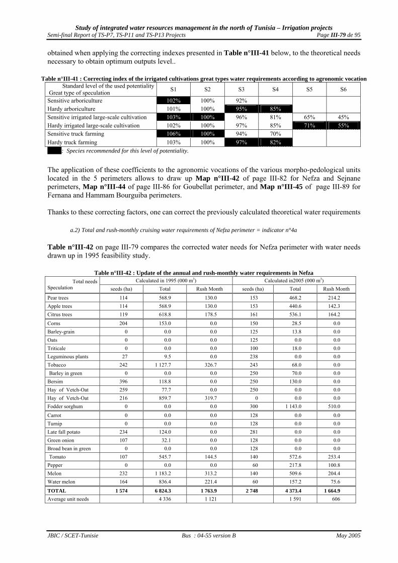
Study of integrated water resources management in the north of Tunisia – Irrigation projects Semi-final Report of TS-P7, TS-P11 and TS-P13 Projects Page III-79 de 95
JBIC / SCET-Tunisie Bus : 04-55 version B May 2005
obtained when applying the correcting indexes presented in Table n°III-41 below, to the theoretical needs necessary to obtain optimum outputs level..
Table n°III-41 : Correcting index of the irrigated cultivations great types water requirements according to agronomic vocation Standard level of the used potentiality
Great type of speculation S1 S2 S3 S4 S5 S6
Sensitive arboriculture 102% 100% 92% Hardy arboriculture 101% 100% 95% 85% Sensitive irrigated large-scale cultivation 103% 100% 96% 81% 65% 45% Hardy irrigated large-scale cultivation 102% 100% 97% 85% 71% 55% Sensitive truck farming 106% 100% 94% 70% Hardy truck farming 103% 100% 97% 82% 106%: Species recommended for this level of potentiality.
The application of these coefficients to the agronomic vocations of the various morpho-pedological units located in the 5 perimeters allows to draw up Map n°III-42 of page III-82 for Nefza and Sejnane perimeters, Map n°III-44 of page III-86 for Goubellat perimeter, and Map n°III-45 of page III-89 for Fernana and Hammam Bourguiba perimeters. Thanks to these correcting factors, one can correct the previously calculated theoretical water requirements
a.2) Total and rush-monthly cruising water requirements of Nefza perimeter = indicator n°4a Table n°III-42 on page III-79 compares the corrected water needs for Nefza perimeter with water needs drawn up in 1995 feasibility study.
Table n°III-42 : Update of the annual and rush-monthly water requirements in Nefza Calculated in 1995 (000 m3) Calculated in2005 (000 m3) Total needs
Speculation seeds (ha) Total Rush Month seeds (ha) Total Rush Month
Pear trees 114 568.9 130.0 153 468.2 214.2 Apple trees 114 568.9 130.0 153 440.6 142.3 Citrus trees 119 618.8 178.5 161 536.1 164.2 Corns 204 153.0 0.0 150 28.5 0.0 Barley-grain 0 0.0 0.0 125 13.8 0.0 Oats 0 0.0 0.0 125 0.0 0.0 Triticale 0 0.0 0.0 100 18.0 0.0 Leguminous plants 27 9.5 0.0 238 0.0 0.0 Tobacco 242 1 127.7 326.7 243 68.0 0.0 Barley in green 0 0.0 0.0 250 70.0 0.0 Bersim 396 118.8 0.0 250 130.0 0.0 Hay of Vetch-Oat 259 77.7 0.0 250 0.0 0.0 Hay of Vetch-Oat 216 859.7 319.7 0 0.0 0.0 Fodder sorghum 0 0.0 0.0 300 1 143.0 510.0
Carrot 0 0.0 0.0 128 0.0 0.0 Turnip 0 0.0 0.0 128 0.0 0.0 Late fall potato 234 124.0 0.0 281 0.0 0.0 Green onion 107 32.1 0.0 128 0.0 0.0 Broad bean in green 0 0.0 0.0 128 0.0 0.0 Tomato 107 545.7 144.5 140 572.6 253.4 Pepper 0 0.0 0.0 60 217.8 100.8 Melon 232 1 183.2 313.2 140 509.6 204.4 Water melon 164 836.4 221.4 60 157.2 75.6
TOTAL 1 574 6 824.3 1 763.9 2 748 4 373.4 1 664.9 Average unit needs 4 336 1 121 1 591 606

Study of integrated water resources management in the north of Tunisia – Irrigation projects Semi-final Report of TS-P7, TS-P11 and TS-P13 Projects Page III-80 de 95
JBIC / SCET-Tunisie Bus : 04-55 version B May 2005
Compared to the feasibility study initial estimations carried out in 1996, the application of these average correcting indexes allows to notice a reduction of 36% of the total water requirements, in spite of the increase in the equipped SAU, because of 63 percent reduction of the initial unit needs which :
• undoubtedly were very largely over-estimated, and • especially did not consider this irrigated perimeter s’ weak agronomic vocation of the added
extensions In contrary, the increase of the irrigated SAU in summer results in a reduction of only 5% of the needs for the rush month, namely July, because of 46 percent reduction of the unit rush needs related to the diversification of the suggested cultivations. By taking account of the geographical variability of the productivity of the four practised great types of cultivations, Map n°III-42 of page III-82 visualizes the geographical distribution of these correcting indexes of water requirements in Nefza perimeter.
a.3) Total and rush-monthly cruising water requirements of Sejnane perimeter = indicator n°4b In the same way, Table n°III-43 of page III-83 compares the results of these correcting calculations for Sejnane perimeter with water requirements drawn up in 1995 feasibility study.

Study of integrated water resources management in the north of Tunisia – Irrigation projects Semi-final Report of TS-P7, TS-P11 and TS-P13 Projects Page III-81 de 95
JBIC / SCET-Tunisie Bus : 04-55 version B May 2005
Map n°III-41 : Optimum grounds occupation in TS-P13 Project perimeters

Study of integrated water resources management in the north of Tunisia – Irrigation projects Semi-final Report of TS-P7, TS-P11 and TS-P13 Projects Page III-82 de 95
JBIC / SCET-Tunisie Bus : 04-55 version B May 2005
Map n°III-42 : Distribution of correcting factors of theoretical water requirements in Nefza perimeter

Study of integrated water resources management in the north of Tunisia – Irrigation projects Semi-final Report of TS-P7, TS-P11 and TS-P13 Projects Page III-83 de 95
JBIC / SCET-Tunisie Bus : 04-55 version B May 2005
Table n°III-43 : Update of annual and rush-monthly water requirements in Sejnane Calculated in 1995 (000 m3) Calculated in2005 (000 m3) Total needs
Speculation seeds (ha) Total Rush Month seeds (ha) Total Rush Month
Pear trees 102 509,0 120,4 192 658.6 301.4 Apple trees 101 504,0 119,2 192 618.2 199.7 Citrus tree 0 0,0 0,0 125 436.3 132.5 Pomegranates 0 0,0 0,0 450 1 224.0 481.5
Corns 0 0,0 0,0 314 78.5 0.0 Barley-grain 0 0,0 0,0 35 5.3 0.0 Oats 0 0,0 0,0 50 0.0 0.0 Triticale 0 0,0 0,0 160 40.0 0.0 Leguminous plants 0 0,0 0,0 265 0.0 0.0 Tobacco 270 1 258,2 364,5 350 1 155.0 479.5 Barley in green 406 0,0 0,0 300 162.0 0.0 Bersim 1 065 319,5 0,0 400 216.0 0.0 Hay of Vetch-Oat 888 266,4 0,0 400 0.0 0.0 Hay of Vetch-Oat 1 120 4 457,6 1 657,6 0 0.0 0.0 Fodder sorghum 0 0,0 0,0 600 2 202.0 984.0
Carrot 0 0,0 0,0 123 0.0 0.0 Turnip 0 0,0 0,0 123 0.0 0.0 potato 0 0,0 0,0 215 0.0 0.0 Green onion 278 83,4 0,0 123 0.0 0.0 Broad bean in green 0 0,0 0,0 123 0.0 0.0 Tomato 0 0,0 0,0 123 474.8 209.1 Pepper 0 0,0 0,0 45 160.2 73.8 Melon 0 0,0 0,0 75 274.5 110.3 Water melon 348 1 774,8 579,4 63 146.8 69.9
TOTAL 2 840 9 172,9 2 841,1 3 590 7 852.1 3 041.7 Average unit needs 3 230 1 000 2 187 847 Compared to 1996 feasibility study initial estimations, the application of these average correcting indexes allows to notice a reduction of 14% of the total water requirements, in spite of the increase in the equipped SAU, because of 32 percent reduction of the initial unit needs which :
• undoubtedly were very largely over-estimated, and • did not consider the distribution of the grounds various agronomic vocations of this irrigated
perimeter. In contrary, one observes in spite of the net increase of the irrigated SAU in summer an increase of only 7% of the needs in rush month, namely July, because of 15 percent reduction of the initial rush month needs.
By taking account of the geographical variability of the productivity of the four practised great types of cultivations, Map n°III-43 of page III-85 visualizes the geographical distribution of these correcting indexes of water requirements in Sejnane perimeter.
a.4) Total and rush-monthly cruising water Requirements for Goubellat perimeter = indicator n°4c Table n°III-44 of page III-84 compares the results of these correcting calculations for Goubellat perimeter with water requirements drawn up in 1996 feasibility study.
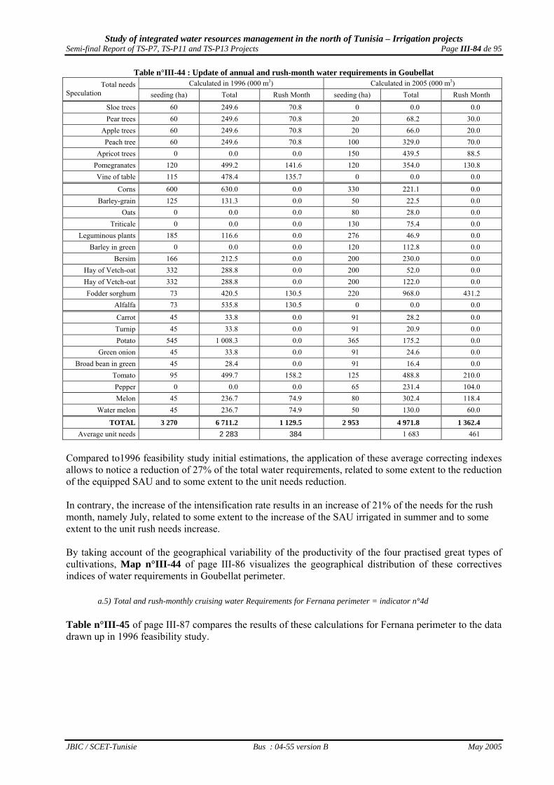
Study of integrated water resources management in the north of Tunisia – Irrigation projects Semi-final Report of TS-P7, TS-P11 and TS-P13 Projects Page III-84 de 95
JBIC / SCET-Tunisie Bus : 04-55 version B May 2005
Table n°III-44 : Update of annual and rush-month water requirements in Goubellat Calculated in 1996 (000 m3) Calculated in 2005 (000 m3) Total needs
Speculation seeding (ha) Total Rush Month seeding (ha) Total Rush Month
Sloe trees 60 249.6 70.8 0 0.0 0.0 Pear trees 60 249.6 70.8 20 68.2 30.0
Apple trees 60 249.6 70.8 20 66.0 20.0 Peach tree 60 249.6 70.8 100 329.0 70.0
Apricot trees 0 0.0 0.0 150 439.5 88.5 Pomegranates 120 499.2 141.6 120 354.0 130.8 Vine of table 115 478.4 135.7 0 0.0 0.0
Corns 600 630.0 0.0 330 221.1 0.0 Barley-grain 125 131.3 0.0 50 22.5 0.0
Oats 0 0.0 0.0 80 28.0 0.0 Triticale 0 0.0 0.0 130 75.4 0.0
Leguminous plants 185 116.6 0.0 276 46.9 0.0 Barley in green 0 0.0 0.0 120 112.8 0.0
Bersim 166 212.5 0.0 200 230.0 0.0 Hay of Vetch-oat 332 288.8 0.0 200 52.0 0.0 Hay of Vetch-oat 332 288.8 0.0 200 122.0 0.0 Fodder sorghum 73 420.5 130.5 220 968.0 431.2
Alfalfa 73 535.8 130.5 0 0.0 0.0
Carrot 45 33.8 0.0 91 28.2 0.0 Turnip 45 33.8 0.0 91 20.9 0.0 Potato 545 1 008.3 0.0 365 175.2 0.0
Green onion 45 33.8 0.0 91 24.6 0.0 Broad bean in green 45 28.4 0.0 91 16.4 0.0
Tomato 95 499.7 158.2 125 488.8 210.0 Pepper 0 0.0 0.0 65 231.4 104.0 Melon 45 236.7 74.9 80 302.4 118.4
Water melon 45 236.7 74.9 50 130.0 60.0
TOTAL 3 270 6 711.2 1 129.5 2 953 4 971.8 1 362.4 Average unit needs 2 283 384 1 683 461
Compared to1996 feasibility study initial estimations, the application of these average correcting indexes allows to notice a reduction of 27% of the total water requirements, related to some extent to the reduction of the equipped SAU and to some extent to the unit needs reduction. In contrary, the increase of the intensification rate results in an increase of 21% of the needs for the rush month, namely July, related to some extent to the increase of the SAU irrigated in summer and to some extent to the unit rush needs increase. By taking account of the geographical variability of the productivity of the four practised great types of cultivations, Map n°III-44 of page III-86 visualizes the geographical distribution of these correctives indices of water requirements in Goubellat perimeter.
a.5) Total and rush-monthly cruising water Requirements for Fernana perimeter = indicator n°4d Table n°III-45 of page III-87 compares the results of these calculations for Fernana perimeter to the data drawn up in 1996 feasibility study.

Study of integrated water resources management in the north of Tunisia – Irrigation projects Semi-final Report of TS-P7, TS-P11 and TS-P13 Projects Page III-85 de 95
JBIC / SCET-Tunisie Bus : 04-55 version B May 2005
Map n°III-43 : Distribution of correcting factors of theoretical water requirements in Sejnane perimeter
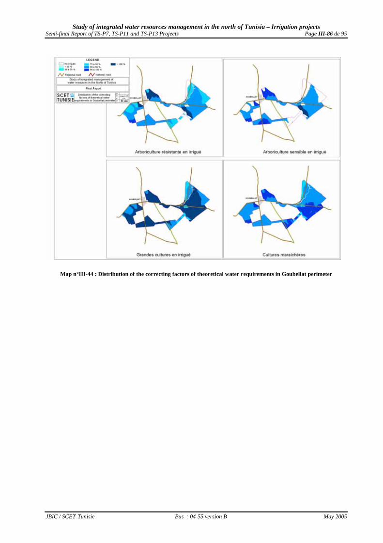
Study of integrated water resources management in the north of Tunisia – Irrigation projects Semi-final Report of TS-P7, TS-P11 and TS-P13 Projects Page III-86 de 95
JBIC / SCET-Tunisie Bus : 04-55 version B May 2005
Map n°III-44 : Distribution of the correcting factors of theoretical water requirements in Goubellat perimeter
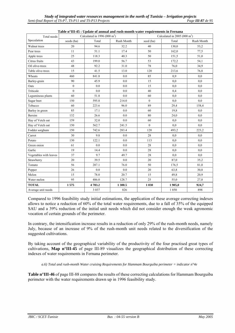
Study of integrated water resources management in the north of Tunisia – Irrigation projects Semi-final Report of TS-P7, TS-P11 and TS-P13 Projects Page III-87 de 95
JBIC / SCET-Tunisie Bus : 04-55 version B May 2005
Table n°III-45 : Update of annual and rush-month water requirements in Fernana Calculated in 1996 (000 m3) Calculated in 2005 (000 m3) Total needs
Speculation seeds (ha) Total Rush Month seed (ha) Total Rush Month
Walnut trees 20 94.6 32.2 40 130,0 53,2 Pear trees 11 51.1 17.4 50 162,0 77,5 Apple trees 25 118.3 40.3 50 151,5 51,0 Citrus fruits 43 199.0 56.7 53 172,2 54,1 Oil olive-trees 48 92.2 31.0 78 76,0 34,9 Table olive-trees 15 41.5 13.0 120 213,6 76,8
Wheats 460 841.8 0.0 85 0,9 0,0 Barley-grain 90 45.9 0.0 15 0,0 0,0 Oats 0 0.0 0.0 15 0,0 0,0 Triticale 0 0.0 0.0 40 0,4 0,0 Leguminous plants 60 51.8 0.0 60 0,0 0,0 Sugar beet 150 595.8 214.0 0 0,0 0,0 Tobacco 60 223.6 96.0 89 29,4 158,4 Barley in green 85 17.1 0.0 60 19,8 0,0 Bersim 132 26.6 0.0 80 24,0 0,0 Hay of Vetch oat 159 32.0 0.0 60 0,0 0,0 Hay of Vetch oat 150 562.7 241.5 0 0,0 0,0 Fodder sorghum 150 742.6 283.4 120 493,2 223,2
Carrot 30 9.8 0.0 28 0,0 0,0 Potato 130 122.1 0.0 113 0,0 0,0 Green onion 61 0.0 0.0 28 0,0 0,0 Garlic 19 14.4 0.0 28 0,0 0,0 Vegetables with leaves 37 9.7 49.7 28 0,0 0,0 Strawberry 20 39.5 0.0 20 87,0 35,2 Tomato 56 287.1 76.0 50 176,5 81,0 Pepper 26 0.0 0.0 20 63,8 30,8 Melon 15 78.0 20.7 15 49,8 20,9 Water melon 95 486.0 128.7 25 55,0 27,8
TOTAL 1 575 4 783.2 1 300.5 1 030 1 905,0 924,7 Average unit needs 3 037 826 1 850 898 Compared to 1996 feasibility study initial estimations, the application of these average correcting indexes allows to notice a reduction of 60% of the total water requirements, due to a fall of 35% of the equipped SAU and a 39% reduction of the initial unit needs which did not consider enough the weak agronomic vocation of certain grounds of the perimeter. In contrary, the intensification increase results in a reduction of only 29% of the rush-month needs, namely July, because of an increase of 9% of the rush-month unit needs related to the diversification of the suggested cultivations. By taking account of the geographical variability of the productivity of the four practised great types of cultivations, Map n°III-45 of page III-89 visualizes the geographical distribution of these correcting indexes of water requirements in Fernana perimeter.
a.6) Total and rush-month Water cruising Requirements for Hammam Bourguiba perimeter = indicator n°4e Table n°III-46 of page III-88 compares the results of these correcting calculations for Hammam Bourguiba perimeter with the water requirements drawn up in 1996 feasibility study.

Study of integrated water resources management in the north of Tunisia – Irrigation projects Semi-final Report of TS-P7, TS-P11 and TS-P13 Projects Page III-88 de 95
JBIC / SCET-Tunisie Bus : 04-55 version B May 2005
Table n°III-46 : Update of annual and rush-month water requirements in Hammam Bourguiba Calculated in 1996 (000 m3) Calculated in 2005 (000 m3) Total needs
Speculation seeds (ha) Total Rush Month seeds (ha) Total Rush Month
Walnut tree 14 71.1 22.8 38 117,7 50,7 Pear tree 19 97.1 31.2 40 127,2 62,8 Apple tree 21 108.4 34.8 40 118,4 41,2 Oil olive tree 26 44.5 17.2 42 48,3 21,6 Table olive tree 48 149.7 43.7 100 165,0 63,0
Wheats 201 422.9 0.0 55 0,0 0,0 Barley-grain 51 36.2 0.0 40 0,0 0,0 Oats 0 0.0 0.0 0 0,0 0,0 Triticale 0 0.0 0.0 60 0,0 0,0 Leguminous plants 0 0.0 0.0 40 0,0 0,0 Tobacco 60 235.4 98.5 90 355,5 157,5 Barley in green 61 23.3 0.0 79 21,3 0,0 Bersim 80 36.6 0.0 60 11,4 0,0 Hay of Vetch oat 80 24.3 0.0 50 0,0 0,0 Fodder corn 70 274.6 114.9 0 0,0 0,0 Fodder sorghum 80 419.2 153.5 90 375,3 171,0
Carrot 0 0.0 0.0 22 0,0 0,0 Turnip 0 0.0 0.0 22 0,0 0,0 Potato 0 0.0 0.0 45 0,0 0,0 Green onion 0 0.0 0.0 22 0,0 0,0 Broad bean in green 0 0.0 0.0 22 0,0 0,0 Tomato 0 0.0 0.0 40 126,0 59,6 Pepper 0 0.0 0.0 15 43,1 21,3 Melon 0 0.0 0.0 20 58,4 25,2 Water melon 0 0.0 0.0 20 47,2 24,6
TOTAL 602 1 943.3 516.7 778 1 614,8 698,5 Average unit needs 3 229 858 2 075 898 Compared to 1996 feasibility study initial estimations, the application of these average correcting indexes allows to notice a reduction of 17% of the total water requirements, because of an increase of 29% of the equipped SAU and a reduction of 35% of the initial unit needs which:
• undoubtedly were very largely over-estimated for arboriculture and summer fodders, and • did not consider enough the distribution of the various agronomic vocations of this perimeter
grounds. In contrary, one observes an increase of 35% of the rush-month needs, namely July, in spite of the increase of the irrigated SAU in summer and an increase of 5% of the unit needs related to the extension of irrigated plantations surfaces. By taking account of the geographical variability of the productivity of the four practised great types of cultivations, Map n°III-46 of page III-90 visualizes the geographical distribution of these correcting indexes of water requirements in Hammam Bourguiba perimeter.

Study of integrated water resources management in the north of Tunisia – Irrigation projects Semi-final Report of TS-P7, TS-P11 and TS-P13 Projects Page III-89 de 95
JBIC / SCET-Tunisie Bus : 04-55 version B May 2005
Map n°III-45 : Distribution of the correcting factors of theoretical water requirements in Fernana perimeter

Study of integrated water resources management in the north of Tunisia – Irrigation projects Semi-final Report of TS-P7, TS-P11 and TS-P13 Projects Page III-90 de 95
JBIC / SCET-Tunisie Bus : 04-55 version B May 2005
Map n°III-46 : Distribution of the correcting factors of theoretical water requirements Hammam Bourguiba perimeter

Study of integrated water resources management in the north of Tunisia – Irrigation projects Semi-final Report of TS-P7, TS-P11 and TS-P13 Projects Page III-91 de 95
JBIC / SCET-Tunisie Bus : 04-55 version B May 2005
The definition of financing requirements
a.7) Agricultural development needs to medium term financing after setting in water a.7.1) Global needs to medium-term financing The optimum grounds occupations proposed in Table n°III-2 of page III-57 for Nefza perimeter, in Table n°III-4 of page III-59 for Sejnane perimeter, in Table n°III-6 of page III-60 for Goubellat peimeter, in Table n°III-8 of page III-61 for Fernana perimeter and in Table n°III-10 of page III-65 for Hammam Bourguiba perimeter, result in needs for investment of 71,3 M.TD, broken down as indicated in Table n°III-47 below.
Table n°III-47 : Estimate of the necessary investments for five perimeters development
Perimeters Irrigation Materials Sensitive plantations Hardy plantations Milk cows Livestock
buildings TOTAL
Unit standard 2 500 3 000 2 200 2 600 600 Nefza 6 870 000 467 ha 1 401 000 0 ha 0 2 750 UZ 7 150 000 1 650 000 17 071 000Sejnane 8 975 000 509 ha 1 527 000 450 ha 990 000 4 300 UZ 11 180 000 2 580 000 25 252 000Goubellat 6 812 500 140 ha 419 711 270 ha 594 388 2 700 UZ 7 020 000 1 620 000 16 466 599Fernana 2 575 000 193 ha 579 000 197 ha 433 400 1 050 UZ 2 730 000 630 000 6 947 400Hm Bourguiba 1 945 000 118 ha 354 000 142 ha 312 400 930 UZ 2 418 000 558 000 5 587 400
TOTAL 27 177 500 1 427 ha 4 280 711 1 059 ha 2 330 188 11 730 UZ 30 498 000 7 038 000 71 324 399 This sum should be mobilized between 2005 and 2010 by 4,500 beneficiary among them a large majority is constituted by small farmers. a.7.2) The 4,500 beneficiaries self-financing needs On these sums, the self-financing to mobilize by the 4,500 beneficiary can be evaluated to 7.1 M.TD and broken down as indicated in Table n°III-48 below.
Table n°III-48 : Estimate of self-financing needs for five perimeters development
Perimeters Irrigation Materials Sensitive plantations Hardy plantations Milk cows Livestock
buildings TOTAL
Loan amounts 10% 10% 10% 10% 10% Nefza 687 000 467 ha 140 100 0 ha 0 2 750 715 000 165 000 1 707 100Sejnane 897 500 509 ha 152 700 450 ha 99 000 4 300 1 118 000 258 000 2 525 200Goubellat 681 250 140 ha 41 971 270 ha 59 439 2 700 702 000 162 000 1 646 660Fernana 257 500 193 ha 57 900 197 ha 43 340 1 050 273 000 63 000 694 740Hm Bourguiba 194 500 118 ha 35 400 142 ha 31 240 930 241 800 55 800 558 740
TOTAL 2 717 750 1 427 ha 428 071 1 059 ha 233 019 11 730 3 049 800 703 800 7 132 440 Among these 7.1 M.TD wich should be mobilized by the 4,500 three projects beneficiary, 1.7 M.TD by Nefza perimeter 980 beneficiaries, 2.5 M.TD by Sejnane perimeter 2,400 beneficiaries and 1.6 M.TD by Goubellat perimeter 570 beneficiaries. a.7.3) Medium-term loans needs On these sums, medium and long-term loans to mobilize can be evaluated to 36.8 M.TD broken down as indicated in the Table n°III-49 of page III-92.

Study of integrated water resources management in the north of Tunisia – Irrigation projects Semi-final Report of TS-P7, TS-P11 and TS-P13 Projects Page III-92 de 95
JBIC / SCET-Tunisie Bus : 04-55 version B May 2005
Table n°III-49 : Estimate of investment loans to allocate for the five perimeter development
Perimeters Irrigation Materials Sensitive plantations Hardy plantations Milk cows Livestock
buildings TOTAL
Loan amounts 30% 65% 65% 65% 65% Nefza 2 061 000 467 ha 910 650 0 ha 0 2 750 4 647 500 1 072 500 8 691 650Sejnane 2 692 500 509 ha 992 550 450 ha 643 500 4 300 7 267 000 1 677 000 13 272 550Goubellat 2 043 750 140 ha 272 812 270 ha 386 352 2 700 4 563 000 1 053 000 8 318 914Fernana 772 500 193 ha 376 350 197 ha 281 710 1 050 1 774 500 409 500 3 614 560Hm Bourguiba 583 500 118 ha 230 100 142 ha 203 060 930 1 571 700 362 700 2 951 060
TOTAL 8 153 250 1 427 ha 2 782 462 1 059 ha 1 514 622 11 730 19 823 700 4 574 700 36 848 734 It is thus 8.2 M.TD which will have to be available to acquire irrigation equipment, 4.3 M.TD for the 2,500 ha of plantations to realize, 19.8 M.TD to acquire cattle and 4.6 M.TD to provide shelter for them. The distribution of these medium - term loans between the various possible sources is presented as a rough guide in Table n°III-50 below, according to the distribution of the surfaces exploited byg the 8 farmers sub category.
Table n°III-50 : Distribution of the investment loans to allocate between the various possible sources Medium term Financing Categories Nefza Sejnane Goubellat Fernana Hm Bourg TOTAL BNA B1, B2 et C 3 105 819 4 470 105 5 324 764 1 937 555 1 438 182 16 276 424BTS A0 et A1 4 947 350 6 039 753 2 765 314 1 597 969 1 298 789 16 649 175Financing associations A2, A3 et A4 638 481 2 762 692 228 836 79 036 214 090 3 923 135 TOTAL 8 691 650 13 272 550 8 318 914 3 614 560 2 951 060 36 848 734
Out of the 36.8 M.TD to distribute as a medium- term loan, 16.3 M.TD will concern the BNA and 16.6 M.TD the BTS directly. Besides, 3.9 M.TD should be allocated to the five loan associations to create, among them 2.8 M.TD for the association to be created in Sejnane and 0.6 M.TD for that of Nefza. a.7.4) Needs for State subsidies Out of these sums, the subsidies to mobilize as State encouragements to the water saving and the agricultural development, can be evaluated to 27.2 MTD, broken down as indicated in Table n°III-51 below.
Table n°III-51 : Estimate of subsidies to grant for the five perimeter development
Perimeters Irrigation Materials Sensitive plantations Hardy plantations Milk cows Livestock
buildings TOTAL
Loan amounts 60% 25% 25% 25% 25% Nefza 4 122 000 467 ha 350 250 0 ha 0 2 750 1 787 500 412 500 6 672 250Sejnane 5 385 000 509 ha 381 750 450 ha 247 500 4 300 2 795 000 645 000 9 454 250Goubellat 4 087 500 140 ha 104 928 270 ha 148 597 2 700 1 755 000 405 000 6 501 025Fernana 1 545 000 193 ha 144 750 197 ha 108 350 1 050 682 500 157 500 2 638 100Hm Bourguiba 1 167 000 118 ha 88 500 142 ha 78 100 930 604 500 139 500 2 077 600
TOTAL 16 306 500 1 427 ha 1 070 178 1 059 ha 582 547 11 730 7 624 500 1 759 500 27 343 225 Out of this total of 27.3 M.TD, the subsidies as State encouragements for water saving will represent 16.3 MTD, i.e. 60%.
a.8) Agricultural development short term financing after the setting in water a.8.1) Needs for short- term financing The optimum grounds occupation proposed in Table n°III-2 of page III-57 for Nefza perimeter, in Table n°III-4 of page III-59 for Sejnane perimeter, in Table n°III-6 of page III-60 for Goubellat peimeter, in Table n°III-8 of page III-61 for Fernana perimeter and in Table n°III-10 of page III-65 for Hammam Bourguiba perimeter, result also in annual needs for countryside loans of 21.9 M.TD, broken down as indicated in Table n°III-52 of page III-93.

Study of integrated water resources management in the north of Tunisia – Irrigation projects Semi-final Report of TS-P7, TS-P11 and TS-P13 Projects Page III-93 de 95
JBIC / SCET-Tunisie Bus : 04-55 version B May 2005
Table n°III-52 : Estimate of countryside loans to grant for the five perimeters development
Perimeter Nefza Sejnane Goubellat Fernana Hm Bourguiba TOTAL Sensitive Arbo 531 060 532 380 207 800 201 350 92 270 1 564 860 Hardy Arbo 0 315 000 189 000 81 963 59 096 645 059 Cereals 188 500 223 980 236 200 61 900 59 200 769 780 Leguminous plants 104 720 116 600 121 440 26 400 17 600 386 760 Tobacco 243 000 350 000 0 89 000 90 000 772 000 winter Fodder 330 000 484 000 228 800 88 000 83 160 1 213 960 summer Fodder 132 000 264 000 220 000 52 800 39 600 708 400 winter Truck farming 1 040 240 880 755 1 096 435 337 697 171 652 3 526 779 summer Truck farming 508 500 411 255 461 375 208 900 131 025 1 721 055
Bovine care 2 475 000 3 870 000 2 430 000 945 000 837 000 10 557 000 TOTAL 5 553 020 7 447 970 5 191 050 2 093 010 1 580 603 21 865 653
a.8.2) Short -term financing distribution between the three possible sources The distribution of these short term loans between the various possible sources is presented as a rough guide in Table n°III-53 below according to the distribution of the exploited surfaces by the 8 farmers sub category.
Table n°III-53 : Distribution of countryside loans to grant between the possible sources Short-term loans Categories Nefza Sejnane Goubellat Fernana Hm Bourg TOTAL BNA B2 et C 871 881 1 428 916 2 744 778 777 033 556 984 6 379 593 BTS A0 et B1 3 277 070 3 074 256 2 057 417 903 895 568 835 9 881 473 Loan associations A1, A2, A3 et A4 1 404 069 2 944 798 388 854 412 081 454 784 5 604 586 TOTAL 5 553 020 7 447 970 5 191 050 2 093 010 1 580 603 21 865 653
Out of the 21.9 M.TD to distribute yearly as short term loans, 6.4 M.TD will concern the BNA, including 2.7 M.TD intended for its Goubellat agency, and 9.9 M.TD the BTS directly, including 5.3 M.DT intended for its Beja agency and 3.1 M.TD for its Bizerte one. Besides, 5.6 M.TD will be allocated from the BTS to the five loan associations to create, among them 1.4 M.TD for that of Nefza and 2.9 M.TD for that of Sejnane.
III.4.3 - Recommended directions for the Action Plan aiming to a good development In order to lay down the Action Plan major directions for a complementary financing to that initial of the JBIC, what was previously emphasized lead to do a whole recommendation set . If the lack of coordination between the services or the weak water price cannot be solved within the framework of the proposed Action Plan because it is definite for the overall agricultural policy of the country, it is in contrary possible to seek solving the three Projects more specific problems taking into consideration the problems human dimension with which the development of the already financed investments will be confronted.
a) Human dimension of the Action plan The inherent constraints in the population of the 4,500 farmer/beneficiary became tangible through various concerns expressed during the participative evaluation meetings that were animated by the study team. Those constraints lead to emphasize the two directions that the complementary program should follow for the good development of the invested sums in the five irrigated perimeter:

Study of integrated water resources management in the north of Tunisia – Irrigation projects Semi-final Report of TS-P7, TS-P11 and TS-P13 Projects Page III-94 de 95
JBIC / SCET-Tunisie Bus : 04-55 version B May 2005
1. A sensitizing and education medium-term program should be implemented to “promote” beneficiaries from agro-shepherd status to a modern farmer status. It will aim to substitute in his mind the concept of quality for that of quantity, and to improve its professional capacities to lead him : o to modify its actual rainfall mixed-farming system towards an intensive irrigated system
evolving for specialization in order to apply more intensive agricultural methods ; o to feed rationally its cattle, to eliminate the non-values and give up his myths and legends
towards a productive livestock farming. 2. It is necessary to arrange the infrastructures according to farmers needs, by ensuring to rural
households the conveniences and services which will encourage the future generations to remain attached to land work. They are facilities of drinking water supply, of communication means between communities, of markets localization, of social services presence, ...
To make evolving mentalities, a technical and material assistance should be provided and the beneficiaries cooperative organization should be encouraged.
a.1) The material and technical assistance to provide: The provided technical and material assistance requires the participation of several trainers, technicians and organizers, and should find its basis on :
o a vocational training adapted to the various needs; o the installation of an appropriate assistance mission to allow a social, economic and technical
changes; o the location as soon as possible, in each perimeter, of leader persons who are particularly
receptive to the irrigation These persons will become organizers through their advices and their concrete demonstrations and will be able to liaise between the agents of popularization services and the assistance mission members in one hand, and the other farmers in the other hand;
o practice of demonstration plots which will have to be led on a surface of the concerned zone and entrusted to an average farmer supported by a team able to approach in a coordinated way all the elements of the problem.
a.2) The encouragement to the beneficiaries cooperative organization
The cooperative organization should be encouraged in spite of its pejorative side remained in the mind of the large majority of tunisian farmers following the unhappy experiment of the end of the Sixties. The fast transformation of the GIC into GDA becomes, indeed, necessary because the volumes of sold water are too small. These GDA will certainly continue to manage irrigation water but will also seek to solve the common difficulties in order to put forward the economic interests of their members who will be able to help:
o programing their investments; o establishing short and long-term production plans;
These structures will be also able to ensure: o the responsibility toward public and private institutions for agricultural loans; o providing them with modern means of production, and technical and social services, o Products development, marketing, conditioning and transformation means, o the search for outlets to facilitate the sale of their products; o the constitution of a stabilization price system.

Study of integrated water resources management in the north of Tunisia – Irrigation projects Semi-final Report of TS-P7, TS-P11 and TS-P13 Projects Page III-95 de 95
JBIC / SCET-Tunisie Bus : 04-55 version B May 2005
The third recommendation is specific to TS-P13 Project two perimeters. It consists in supporting the constitution of the necessary GIC, at least two in Fernana and if possible two in Hammam Bourguiba. It is necessary to accelerate the recruitment of a technical director there (to supervise the four GIC there) on the model of those recruited for Nefza and Goubellat perimeters (supervising the whole Nefza perimeter and the half of Goubellat perimeter), as well as the installation of an assistance program for the offices to be constituted, in order to train them for the perimeters management- and for the technical staff to be recruited to train them for perimeters management and maintenance.
b) Action plan technical and financial aspects Once the 3.600 beneficiay gradually reassured about their becoming as farmers of an irrigated plot in the 5 perimeters arranged within the framework of the three Projects and becoming - thanks to the previous recommended measures - more efficient in matter of irrigated agriculture and of integrated livestock farming, a whole series of actions will have to be started during the following years in order to enable them to guarantee the good development of the carried out installations.
b.1) Actions to improve support to farmers In addition to the improvement of the beneficiaries technical level, several actions can ensure to them a better support on behalf of support institutions depending of M/ARH :
1. the development of the research applied on irrigated production systems specific to the tunisian North-West via a research programme implemented in the North-West Regional Pole of Research-Development based in Beja, which will do coordination works between INRAT, INRGREF, Mateur ESA, Kef ESA and Tabarka ISP in order to seek the economic optimum for a " cautious " irrigated agriculture ;
2. The popularization development on the irrigated cultivations specific to Tunisia North-west by
reinforcing the resources of the 5 CTV concerned that are actually dimensioned to ensure pluvial cultivations popularization
3. The mobilization of the Tobaccos Control so that it gives all its support to the concerned irrigators
for carrying out the planned Tobacco areas on the four perimeters irrigated by fresh water, where it can hope to develop seeds of its new light varieties;
b.2) Actions to solve land problems
Several actions can help to solve land problems that are an important constraint for the good development. In fact, the land audit goes through the reinforcement of the budget allocated to the AFA in order to have finally a room for operation to really apply its primacies and implement a real land reform policy. So, it should constitute a fund to acquire a land stock to extend the micro-exploitations (micro-farms) through bying: 1. the fields of beneficiaries prepared to retirement in exchange for a lump sum /base hectar and a
life annuity according to the departure age 2. the fields surplus of wide exploitations( wide farms) because they exceed the maximum SAU of
the decree on irrigated perimeters creation
b.3) Actions to guarantee the success of irrigation development Several actions can improve the functioning and maintenance of the hydraulic equipment installed thanks to the JBIC financing, and reassure the farmers about the concerns they showed:

Study of integrated water resources management in the north of Tunisia – Irrigation projects Semi-final Report of TS-P7, TS-P11 and TS-P13 Projects Page III-96 de 95
JBIC / SCET-Tunisie Bus : 04-55 version B May 2005
1. technical modifications on the level of the irrigation water pumping out, adducting and supplying systems to improve its efficiency:
• increase in the available flow in the terminals for Goubellat perimeter till 0,5-0,6 L /s /ha once obtained agreement on the new occupation of the ground is proposed above,
• elimination of the shared terminals (“bornes-foyer”) by multiplication of terminals where it is useful, and
• reinforcement of the water filtering systems in the pumping out stations on Sejnane, Mejerdah and Magroun rivers ;
2. The realization of an anti-erosive adjustment program on the slopes surrounding the perimeters,
from which come the streaming potentially able to deteriorate the installations carried out on the perimeters ;
3. consolidation of the drainage networks in all the zones threatened by erosion, and installation of
two types of salinity supervision systems : • the first for the clayey grounds in Goubellat perimeter, and • the second for the drainage water released by the all the perimeters sanitation networks in the
rivers and the dam ponds located in their immediate downstream ;
4. To carry out salinity supervision (Goubellat) or the sheets level (Nefza, Sejnane, Goubellat, Fernana and Hamam Bourguiba ) in the irrigated grounds.
5. The constitution of a credit line for BTS to be managed directly by five local credit associations to
be installed near the farmers in Nefza, Sejnane, Goubellat, Fernana and Hammam Bourguiba (Aîn Draham), on the model of that constituted within the PACFs financing system installed in 8 pilot delegation of the country but having more ambitious financing objectives concerning: • Plot equipments for irrigation water saving, • Transportation means to facilitate the productions sale and distribution, • Storage infrastructures to spread out the production periods.
6. To provide a payment security system on the model installed within the PACFS financial system
framework