Embed Size (px)
Citation preview
FAREWELLLAKE
LODGE
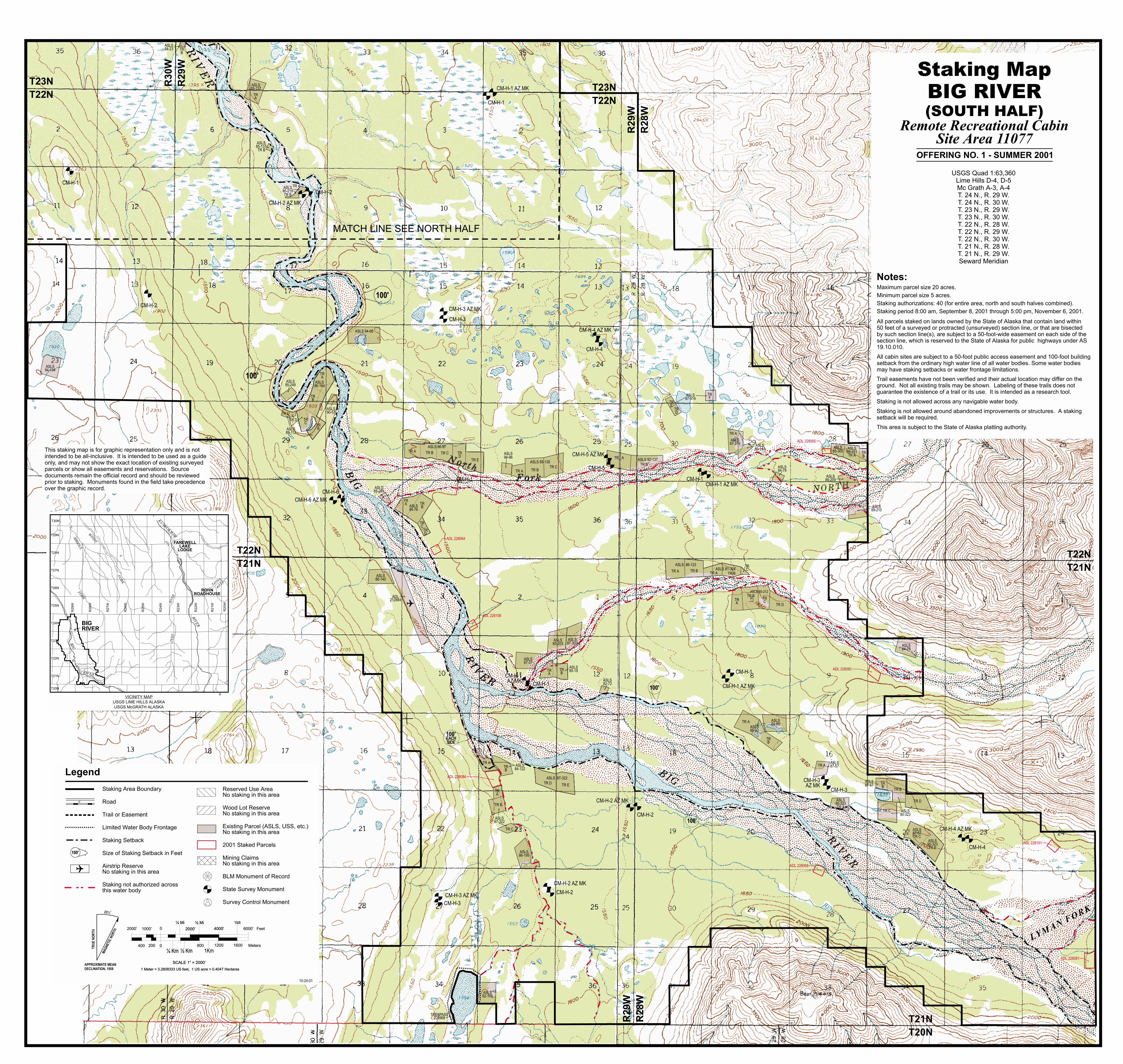
BIGRIVER
T29N
T28N
T27N
T26N
T25N
T24N
T23N
T22N
T21N
R29W
R28W
R27W
R26W
R25W
R24W
R23W
BIG
RIVER
WIN
DY
FO
RK
KU
SKO
KW
IM
RIV
ER
PO
ST
RIV
ER
TATINA
RIV
ER
ROHNROADHOUSE
MID
DLE
FO
RK
VICINITY MAP
USGS LIME HILLS ALASKA
USGS McGRATH ALASKA
T30N
T20N
R22W
R21W
R20W
��������
TRESPASS226968
TR A TR B
R29W
R28W
R29W
R28W
R30W
R29W
T23N
T22NT23N
T22N
T21N
T20N
T22N
T21NT22N
T21N
CM-H-2
CM-H-2 AZ MK
CM-H-1
CM-H-3 AZ MK
CM-H-1 AZ MK
CM-H-1
CM-H-6 AZ MK
CM-H-1 AZ MK
CM-H-4 AZ MK
CM-H-3AZ MK
CM-H-2 AZ MK
CM-H-5 AZ MK
CM-H-1 AZ MK
CM-H-4 AZ MK
CM-H-3
CM-H-1
CM-H-6
CM-H-2
CM-H-1
CM-H-1
CM-H-4
CM-H-3
CM-H-2
CM-H-3 AZ MK
CM-H-3
CM-H-2 AZ MK
CM-H-2
CM-H-5
CM-H-1
CM-H-4
MATCH LINE SEE NORTH HALF
ASLS85-137
ASLS85-137
ASLS84-23
ASLS85-219
ASLS 94-68
ASLS85-249
ASLS94-134
ASLS86-164
ASLS90-57
ASLS89-112
ASLS85-269
ASLS84-76
ASLS 86-97
ASLS 85-135ASLS 92-137
ASLS94-96
ASLS84-79
ASLS89-141
ASLS87-319
ASLS87-319
ASLS85-305
ASLS89-209
ASLS89-210
ASLS89-151TR A
TRB
ASLS 85-212
ASLS 86-123
ASLS 81-324
ASLS82-72
ASLS85-19
ASLS87-37
ASLS85-203
ASLS87-323
ASLS86-140
ASLS84-122
ASLS87-322
ASLS86-195
ASLS 87-322
ASLS92-178
ASLS86-93
ASLS84-85
ASLS90-323TR A
ASLS87-57
ASLS87-57
ASLS90-323
ASLS90-323TR E
ASLS87-57TR C
ASLS84-78
ADL 228060
ADL 228084
ADL 228068
ADL 228081
ADL 228065
ADL 228064
ADL 228108
ADL 228101
TRB
TRA
TR B
TR B
TR A
TR E
TR D
TRA
TRB
TRC
TRB
TR A
TR A
TR B
TR B
TR C
TR CTR B
TR A
TRE
TRD
TRF
TR A
TRD
TR E
TRA TR
B
TRC
TRD
ADL212884
TRA
TRB
TR A
TRB
TR A
TRB
TR C
TR B
TR D
TR A
TRB
TR DTR E
TRA
TR B
TR C
TR A TR B
TRC
TRA
TR BTRC
TR D
OFFERING NO. 1 - SUMMER 2001
LYMA
NF
OR
K
10-24-01
CM-H-1AZ MK
SCALE 1” = 2000’SCALE 1” = 2000’
1 Meter = 3.2808333 US feet, 1 US acre = 0.4047 Hectares1 Meter = 3.2808333 US feet, 1 US acre = 0.4047 Hectares
1000’ 0
0400 200
2000’2000’ 4000’4000’ 6000’ Feet
¼ Km¼ Km ½ Km½ Km 1Km
800 1200 1600 Meters
¼ Mi¼ Mi ½ Mi½ Mi 1Mi
2000’
USGS Quad 1:63,360Lime Hills D-4, D-5Mc Grath A-3, A-4T. 24 N., R. 29 W.T. 24 N., R. 30 W.T. 23 N., R. 29 W.T. 23 N., R. 30 W.T. 22 N., R. 28 W.T. 22 N., R. 29 W.T. 22 N., R. 30 W.T. 21 N., R. 28 W.T. 21 N., R. 29 W.Seward Meridian
Staking MapBIG RIVER(
Remote Recreational Cabin
Site Area 11077
SOUTH HALF)
APPROXIMATE MEAN
DECLINATION, 1958
Staking Area Boundary
Road
Trail or Easement
Limited Water Body Frontage
Staking Setback
Size of Staking Setback in Feet
Airstrip ReserveNo staking in this area
Staking not authorized acrossthis water body
Legend
BLM Monument of Record
State Survey Monument
Survey Control Monument
Reserved Use AreaNo staking in this area
Wood Lot ReserveNo staking in this area
Existing Parcel (ASLS, USS, etc.)No staking in this area
2001 Staked Parcels
Mining ClaimsNo staking in this area
100'
100'
100'EACHSIDEEACHSIDE
100'
100'
or
100'
TR
UE
NO
RT
H
MA
GN
ETIC
NO
RTH
23½
Maximum parcel size 20 acres.
Minimum parcel size 5 acres.
Staking authorizations: 40 (for entire area, north and south halves combined).
Staking period 8:00 am, September 8, 2001 through 5:00 pm, November 6, 2001.
All parcels staked on lands owned by the State of Alaska that contain land within50 feet of a surveyed or protracted (unsurveyed) section line, or that are bisectedby such section line(s), are subject to a 50-foot-wide easement on each side of thesection line, which is reserved to the State of Alaska for public highways under AS19.10.010.
All cabin sites are subject to a 50-foot public access easement and 100-foot buildingsetback from the ordinary high water line of all water bodies. Some water bodiesmay have staking setbacks or water frontage limitations.
Notes:
Trail easements have not been verified and their actual location may differ on theground. Not all existing trails may be shown. Labeling of these trails does notguarantee the existence of a trail or its use. It is intended as a research tool.
Staking is not allowed across any navigable water body.
Staking is not allowed around abandoned improvements or structures. A stakingsetback will be required.
This area is subject to the State of Alaska platting authority.
This staking map is for graphic representation only and is notintended to be all-inclusive. It is intended to be used as a guideonly, and may not show the exact location of existing surveyedparcels or show all easements and reservations. Sourcedocuments remain the official record and should be reviewedprior to staking. Monuments found in the field take precedenceover the graphic record.