Embed Size (px)
Citation preview
7/26/2019 teori gnss
http://slidepdf.com/reader/full/teori-gnss 1/73
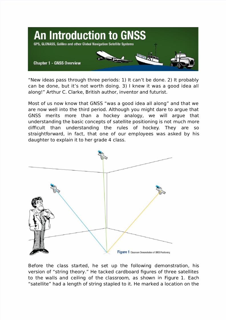
“New ideas pass through three periods: 1) It can’t be done. 2) It probably
can be done, but it’s not worth doing. 3) I knew it was a good idea all
along! "rthur #. #larke, $ritish author, in%entor and &uturist.
'ost o& us now know that (N “was a good idea all along! and that we
are now well into the third period. "lthough you *ight dare to argue that
(N *erits *ore than a hockey analogy, we will argue that
understanding the basic concepts o& satellite positioning is not *uch *ore
di+cult than understanding the rules o& hockey. hey are so
straight&orward, in &act, that one o& our e*ployees was asked by his
daughter to e-plain it to her grade class.
$e&ore the class started, he set up the &ollowing de*onstration, his
%ersion o& “string theory.! /e tacked cardboard 0gures o& three satellites
to the walls and ceiling o& the classroo*, as shown in igure 1. ach
“satellite! had a length o& string stapled to it. /e *arked a location on the
7/26/2019 teori gnss
http://slidepdf.com/reader/full/teori-gnss 2/73
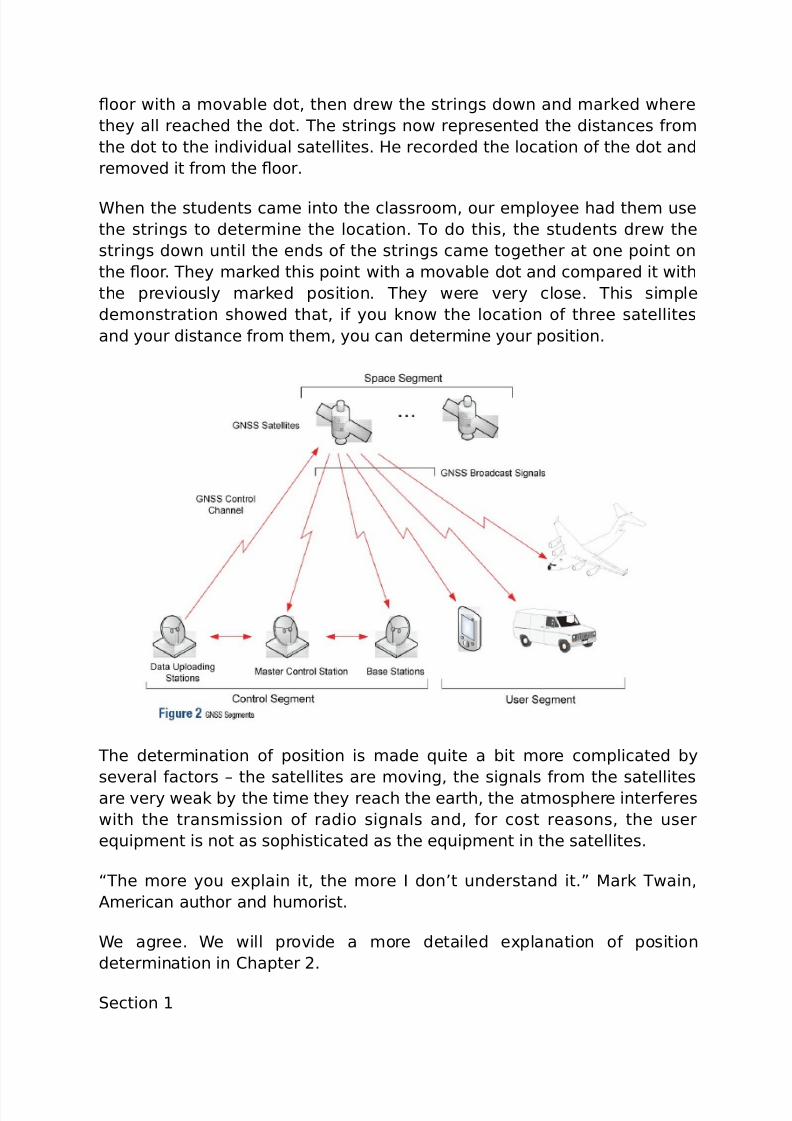
oor with a *o%able dot, then drew the strings down and *arked where
they all reached the dot. he strings now represented the distances &ro*
the dot to the indi%idual satellites. /e recorded the location o& the dot and
re*o%ed it &ro* the oor.
4hen the students ca*e into the classroo*, our e*ployee had the* use
the strings to deter*ine the location. o do this, the students drew the
strings down until the ends o& the strings ca*e together at one point on
the oor. hey *arked this point with a *o%able dot and co*pared it with
the pre%iously *arked position. hey were %ery close. his si*ple
de*onstration showed that, i& you know the location o& three satellites
and your distance &ro* the*, you can deter*ine your position.
he deter*ination o& position is *ade 5uite a bit *ore co*plicated by
se%eral &actors 6 the satellites are *o%ing, the signals &ro* the satellites
are %ery weak by the ti*e they reach the earth, the at*osphere inter&eres
with the trans*ission o& radio signals and, &or cost reasons, the user
e5uip*ent is not as sophisticated as the e5uip*ent in the satellites.
“he *ore you e-plain it, the *ore I don’t understand it.! 'ark wain,
"*erican author and hu*orist.
4e agree. 4e will pro%ide a *ore detailed e-planation o& position
deter*ination in #hapter 2.
ection 1
7/26/2019 teori gnss
http://slidepdf.com/reader/full/teori-gnss 3/73
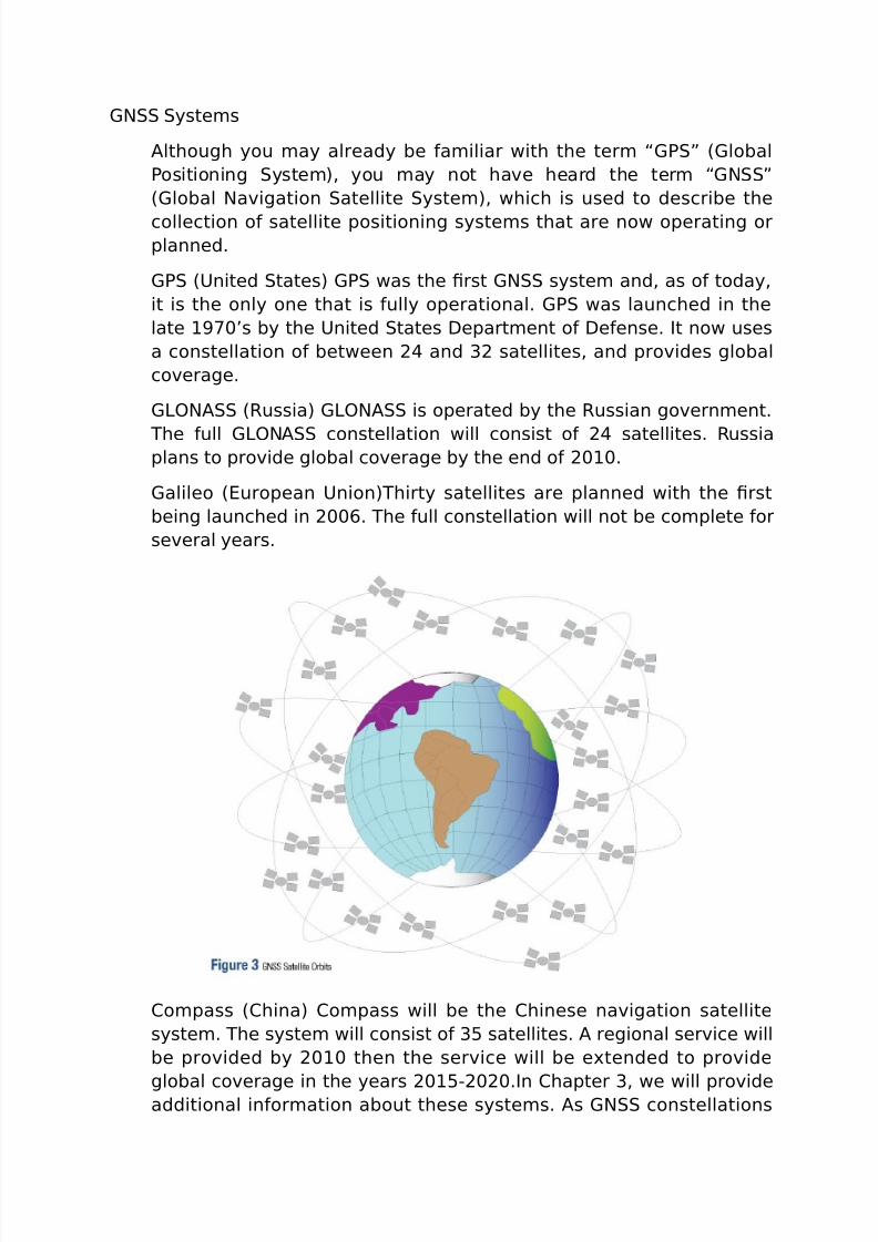
(N yste*s
"lthough you *ay already be &a*iliar with the ter* “(7! 8(lobal
7ositioning yste*), you *ay not ha%e heard the ter* “(N!
8(lobal Na%igation atellite yste*), which is used to describe the
collection o& satellite positioning syste*s that are now operating orplanned.
(7 89nited tates) (7 was the 0rst (N syste* and, as o& today,
it is the only one that is &ully operational. (7 was launched in the
late 1;<’s by the 9nited tates =epart*ent o& =e&ense. It now uses
a constellation o& between 2 and 32 satellites, and pro%ides global
co%erage.
(>?N" 8@ussia) (>?N" is operated by the @ussian go%ern*ent.
he &ull (>?N" constellation will consist o& 2 satellites. @ussiaplans to pro%ide global co%erage by the end o& 2<1<.
(alileo 8uropean 9nion)hirty satellites are planned with the 0rst
being launched in 2<<A. he &ull constellation will not be co*plete &or
se%eral years.
#o*pass 8#hina) #o*pass will be the #hinese na%igation satellite
syste*. he syste* will consist o& 3B satellites. " regional ser%ice will
be pro%ided by 2<1< then the ser%ice will be e-tended to pro%ide
global co%erage in the years 2<1BC2<2<.In #hapter 3, we will pro%ideadditional in&or*ation about these syste*s. "s (N constellations

7/26/2019 teori gnss
http://slidepdf.com/reader/full/teori-gnss 4/73
and satellites are added, we will be able to calculate position *ore
accurately and in *ore and *ore places.
(N "rchitecture
“he &uture ain’t what it used to be.! Dogi $erra, &or*er 'aEor >eague$aseball player and *anager.
'r. $erra is correct. he i*ple*entation o& (N satellite syste*s
has really changed things.
(N satellite syste*s consist o& three *aEor co*ponents or
“seg*ents!: space seg*ent, control seg*ent and user seg*ent.
hese are illustrated in igure 2.
pace eg*ent
Dour &riend returns a couple o& *inutes later, listens to your
*essage and “processes! it, then calls you back and suggests
you co*e up a slightly diFerent wayG eFecti%ely, your &riend has
gi%en you an “orbit correction.!Dou know you are so*ewhere on
this circle 7erson "’s /ouse
#ontrol eg*ent
he control seg*ent co*prises a groundCbased network o&
*aster control stations, data uploading stations, and *onitor
stationsG in the case o& (7, two *aster control stations 8one
pri*ary and one backup), &our data uploading stations and ten*onitor stations, located throughout the world.
7/26/2019 teori gnss
http://slidepdf.com/reader/full/teori-gnss 5/73
In each (N syste*, the *aster control station adEusts the
satellites’ orbit para*eters and onboard highCprecision clocks
when necessary to *aintain accuracy.
'onitor stations, usually installed o%er a broad geographic area,
*onitor the satellites’ signals and status, and relay thisin&or*ation to the *aster control station. he *aster control
station analyses the signals then trans*its orbit and ti*e
corrections to the satellites through data uploading stations.
9ser eg*ent
he user seg*ent consists o& e5uip*ent that processes the
recei%ed signals &ro* the (N satellites and uses the* to
deri%e and apply location and ti*e in&or*ation. he e5uip*ent
ranges &ro* handheld recei%ers used by hikers, to sophisticated,specialiHed recei%ers used &or highCend sur%ey and *apping
applications.
ection 2
(N ignals
(N radio signals are 5uite co*ple-. heir &re5uencies are around1.B (/H 8gigahertH) 6 1.B billion cycles per second. (N operates at
&re5uencies that are higher than ' radio, but lower than a
*icrowa%e o%en. $y the ti*e (N signals reach the ground, they
are %ery, %ery weak. 4e will pro%ide *ore in&or*ation about how the
user seg*ent deals with this in #hapter 2.
7/26/2019 teori gnss
http://slidepdf.com/reader/full/teori-gnss 6/73
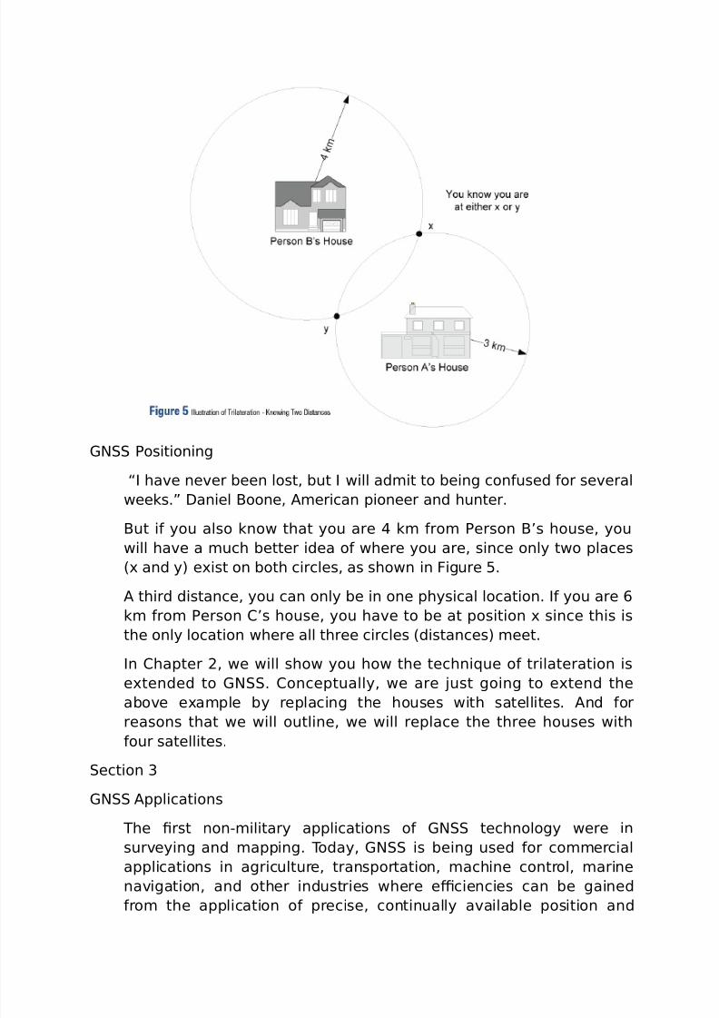
(N 7ositioning
“I ha%e ne%er been lost, but I will ad*it to being con&used &or se%eral
weeks.! =aniel $oone, "*erican pioneer and hunter.
$ut i& you also know that you are k* &ro* 7erson $’s house, youwill ha%e a *uch better idea o& where you are, since only two places
8- and y) e-ist on both circles, as shown in igure B.
" third distance, you can only be in one physical location. I& you are A
k* &ro* 7erson #’s house, you ha%e to be at position - since this is
the only location where all three circles 8distances) *eet.
In #hapter 2, we will show you how the techni5ue o& trilateration is
e-tended to (N. #onceptually, we are Eust going to e-tend the
abo%e e-a*ple by replacing the houses with satellites. "nd &or
reasons that we will outline, we will replace the three houses with
&our satellites.
ection 3
(N "pplications
he 0rst nonC*ilitary applications o& (N technology were in
sur%eying and *apping. oday, (N is being used &or co**ercial
applications in agriculture, transportation, *achine control, *arine
na%igation, and other industries where e+ciencies can be gained&ro* the application o& precise, continually a%ailable position and
7/26/2019 teori gnss
http://slidepdf.com/reader/full/teori-gnss 7/73
ti*e in&or*ation. (N is also used in a broad range o& consu*er
applications, including %ehicle na%igation, *obile co**unications,
hiking and athletics. "s (N technology i*pro%es and beco*es less
e-pensi%e, *ore and *ore applications will be concei%ed and
de%eloped.
In addition to position, (N recei%ers can pro%ide users with %ery
accurate ti*e, by “synchroniHing! their local clock with the highC
precision clocks onboard the satellites. his has enabled technologies
and applications such as the synchroniHation o& power grids, cellular
syste*s, the internet and 0nancial networks.
4e’ll talk *ore about (N applications in #hapter B.
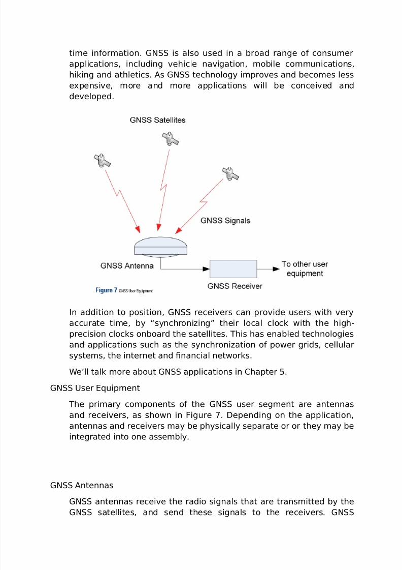
(N 9ser 5uip*ent
he pri*ary co*ponents o& the (N user seg*ent are antennas
and recei%ers, as shown in igure ;. =epending on the application,
antennas and recei%ers *ay be physically separate or or they *ay be
integrated into one asse*bly.
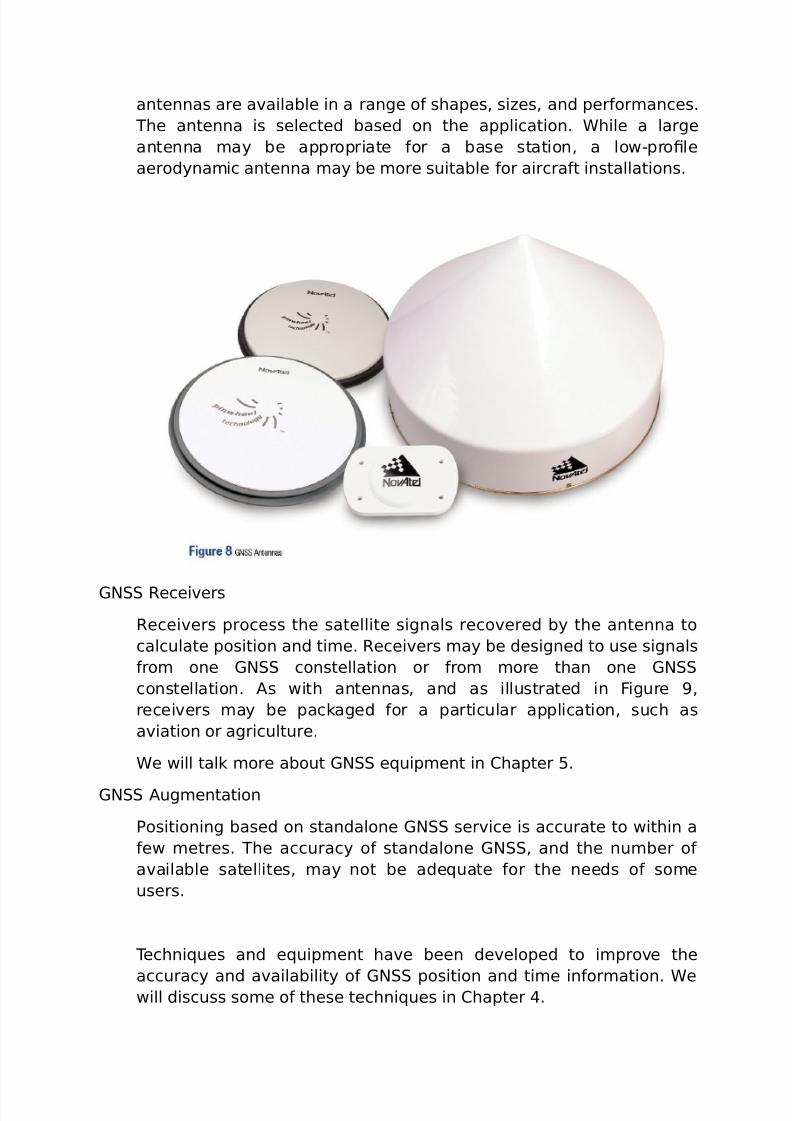
(N "ntennas
(N antennas recei%e the radio signals that are trans*itted by the(N satellites, and send these signals to the recei%ers. (N
7/26/2019 teori gnss
http://slidepdf.com/reader/full/teori-gnss 8/73
antennas are a%ailable in a range o& shapes, siHes, and per&or*ances.
he antenna is selected based on the application. 4hile a large
antenna *ay be appropriate &or a base station, a lowCpro0le
aerodyna*ic antenna *ay be *ore suitable &or aircra&t installations.
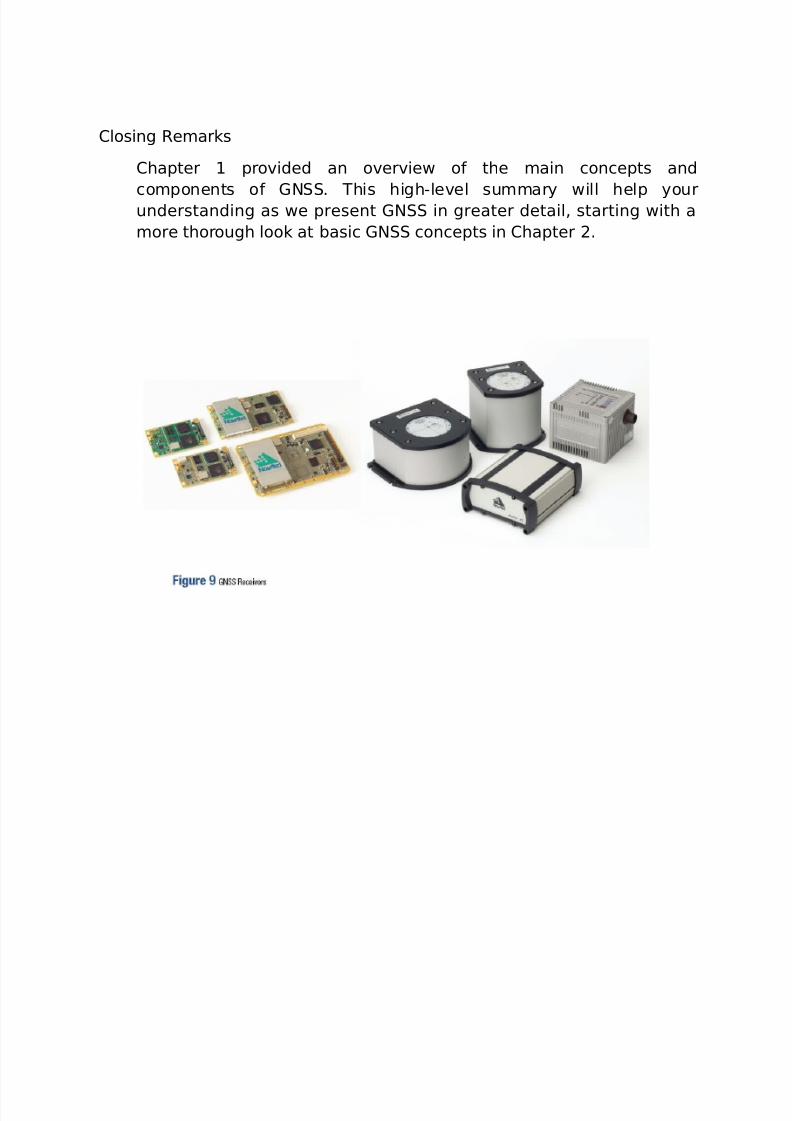
(N @ecei%ers
@ecei%ers process the satellite signals reco%ered by the antenna to
calculate position and ti*e. @ecei%ers *ay be designed to use signals
&ro* one (N constellation or &ro* *ore than one (N
constellation. "s with antennas, and as illustrated in igure ,
recei%ers *ay be packaged &or a particular application, such as
a%iation or agriculture.
4e will talk *ore about (N e5uip*ent in #hapter B.
(N "ug*entation
7ositioning based on standalone (N ser%ice is accurate to within a
&ew *etres. he accuracy o& standalone (N, and the nu*ber o&
a%ailable satellites, *ay not be ade5uate &or the needs o& so*e
users.
echni5ues and e5uip*ent ha%e been de%eloped to i*pro%e the
accuracy and a%ailability o& (N position and ti*e in&or*ation. 4ewill discuss so*e o& these techni5ues in #hapter .
7/26/2019 teori gnss
http://slidepdf.com/reader/full/teori-gnss 9/73
#losing @e*arks
#hapter 1 pro%ided an o%er%iew o& the *ain concepts and
co*ponents o& (N. his highCle%el su**ary will help yourunderstanding as we present (N in greater detail, starting with a
*ore thorough look at basic (N concepts in #hapter 2.
7/26/2019 teori gnss
http://slidepdf.com/reader/full/teori-gnss 10/73
In this chapter, we will introduce basic (N concepts. 4e’ll discuss
*ore ad%anced concepts in #hapter .
“"ny su+ciently ad%anced technology is indistinguishable &ro*
*agic.! "rthur #. #larke.
(N *ay at 0rst see* like *agic, but the *ore you study and learn
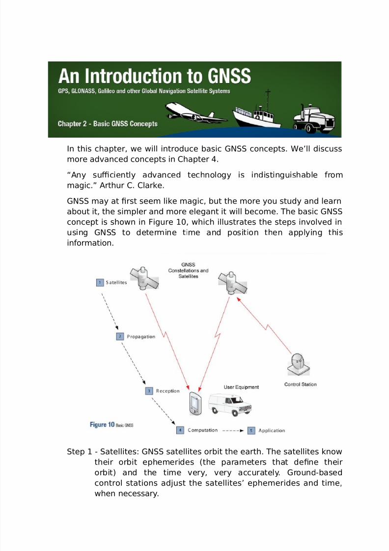
about it, the si*pler and *ore elegant it will beco*e. he basic (N
concept is shown in igure 1<, which illustrates the steps in%ol%ed in
using (N to deter*ine ti*e and position then applying this
in&or*ation.
tep 1 C atellites: (N satellites orbit the earth. he satellites know
their orbit ephe*erides 8the para*eters that de0ne their
orbit) and the ti*e %ery, %ery accurately. (roundCbased
control stations adEust the satellites’ ephe*erides and ti*e,when necessary.
7/26/2019 teori gnss
http://slidepdf.com/reader/full/teori-gnss 11/73
tep 2 C 7ropagation: (N satellites regularly broadcast their
ephe*erides and ti*e, as well as their status. (N radio
signals pass through layers o& the at*osphere to the user
e5uip*ent.
tep 3 C @eception: (N user e5uip*ent recei%es the signals &ro**ultiple (N satellites then, &or each satellite, reco%ers the
in&or*ation that was trans*itted and deter*ines the ti*e o&
propagation, the ti*e it takes the signals to tra%el &ro* the
satellite to the recei%er.
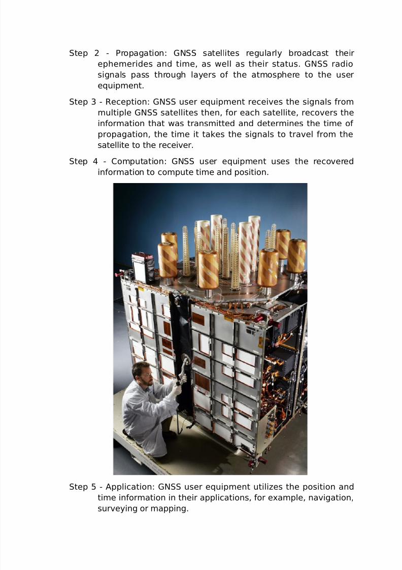
tep C #o*putation: (N user e5uip*ent uses the reco%ered
in&or*ation to co*pute ti*e and position.
tep B C "pplication: (N user e5uip*ent utiliHes the position and
ti*e in&or*ation in their applications, &or e-a*ple, na%igation,sur%eying or *apping.
7/26/2019 teori gnss
http://slidepdf.com/reader/full/teori-gnss 12/73
In the &ollowing sections, we will discuss each o& the abo%e steps in
*ore detail.
tep 1 C atellites
here are *ultiple constellations o& (N satellites orbiting theearth. " constellation is si*ply an orderly grouping o& satellites,
typically 2<C 3<, in orbits that ha%e been designed to pro%ide a
desired co%erage, &or e-a*ple, regional or global. 4e will
pro%ide *ore details about (N constellations in #hapter 3.
(N satellites orbit well abo%e the at*osphere, about 2<,<<<
k* abo%e the earth’s sur&ace. hey are *o%ing %ery &ast, se%eral
kilo*etres per second.
(N satellites are not as s*all as you *ight think. he latest
generation o& (7 satellites weighs o%er 1<<< kg, a bit *ore
than the weight o& a olkswagen $eetle. he 0rst generation o&
(alileo satellites will weigh about ;<< kg, and the body o& these
satelliteswill be 2.; * - 1.2 * - 1.1 *. 4hen the satellite’s solar
arrays 8the large panels that collect the sun’s energy and use it
to power the satellite) are deployed, they will be o%er 1J * in
length. igure 11 shows a picture o& the body o& a $lock II@ (7
satellite, to gi%e a sense o& how large they are.
In the relati%e %acuu* o& space, satellite traEectories are %ery
stable and predictable. "s *entioned, (N satellites know their
ti*e and orbit ephe*erides %ery, %ery accurately. I& you ask a
(7 satellite &or the ti*e, it won’t tell you eight thirty. It will tell
you J:31.3J;B21.
he latest generation o& (7 satellites uses rubidiu* clocks that
are accurate to within KB parts in 1<11. hese clocks aresynchroniHed by *oreCaccurate groundCbased cesiu* clocks. Dou
7/26/2019 teori gnss
http://slidepdf.com/reader/full/teori-gnss 13/73
would need to watch one o& these cesiu* clocks &or o%er
1<<,<<< years to see it gain or lose a second. $y co*parison, i&
you ha%e a 5uartH watch, it will likely ha%e an accuracy o& KB
parts in 1<A and will lose about a second e%ery two days.
$y the way, i& all (N recei%ers needed a rubidiu* standard,the %iability o& (N would 5uickly collapse. >ater in the chapter,
we will describe the elegant way (N syste*s “trans&er! the
accuracy o& the satellite clocks to (N recei%ers.
Dou *ay be wondering why ti*e is such a big deal in (N
syste*s. It is because the ti*e it takes a (N signal to tra%el
&ro* satellites to recei%ers is used to deter*ine distances
8ranges) to satellites. "ccuracy is re5uired because radio wa%es
tra%el at the speed o& light. In one *icrosecond 8a *illionth o& a
second), light tra%els 3<< *. In a nanosecond 8a billionth o& a
second), light tra%els 3< c*. *all errors in ti*e can result in
large errors in position.
(7 was the 0rst (N constellation to be launched. "t a cost o&
9L12 billion, it is the *ost accurate na%igation syste* in the
world. he @ussian (>?N" constellation has also been
launched and is operational. he bene0t to end users o& ha%ing
access to *ultiple constellations is redundancy and a%ailability. I&
one syste* &ails, &or any reason, (N recei%ers, i& they aree5uipped to do so, can recei%e and use signals &ro* satellites in
other syste*s. yste* &ailure does not happen o&ten, but it is
nice to know that i& it did, your recei%er *ay still be able to
operate.
7/26/2019 teori gnss
http://slidepdf.com/reader/full/teori-gnss 14/73
@egardless, access to *ultiple constellations is o& particular
bene0t where line o& sight to so*e o& the satellites is obstructed,
as is o&ten the case in urban or &oliated areas.
atellite ?rbits
(N satellites orbit well abo%e the arth’s at*osphere.
(7 and (>?N" satellites orbit at altitudes close to
2<,<<< k*. (alileo satellites will orbit a bit higher, around
23,<<< k*. (N orbits, which are *ore or less circular, and
highly stable and predictable, &all into the category o& '?,
&or *ediu* earth orbit.
here is not *uch drag at 2<,<<< k*, but gra%itational
eFects and the pressure o& solar radiation do aFect (N
orbits a bit and the orbits ha%e to be occasionally corrected.4hile its orbit is being adEusted, a (N satellite’s status is
changed to “out o& ser%ice! so user e5uip*ent knows not to
use their signals.
atellite ignals
“%erything should be *ade as si*ple as possible, but no
si*pler.! "lbert instein.
(N satellite signals are co*ple-. =escribing these signals
re5uires e5ually co*ple- words like pseudorando*,correlation, and code di%ision *ultiple access 8#='"). o
e-plain these (N concepts, let’s 0rst discuss (7 satellite
signals.
irst and &ore*ost, (7 was designed as a positioning
syste* &or the 9 =epart*ent o& =e&ense. o pro%ide highC
accuracy position in&or*ation &or *ilitary applications, a lot
o& co*ple-ity was designed into the syste* to *ake it
secure and i*per%ious to Ea**ing and inter&erence.
"lthough *ilitary and ci%ilian co*ponents o& (7 are
separate, so*e o& the technologies used in the *ilitary
co*ponent ha%e been applied to the ci%ilian co*ponent.
7/26/2019 teori gnss
http://slidepdf.com/reader/full/teori-gnss 15/73
ince it achie%ed initial operational capability in =ece*ber
13, (7 has been a%ailable to ci%ilian users, who ha%e
diFerent re5uire*ents &or ser%ice a%ailability, positioning
accuracy and cost.
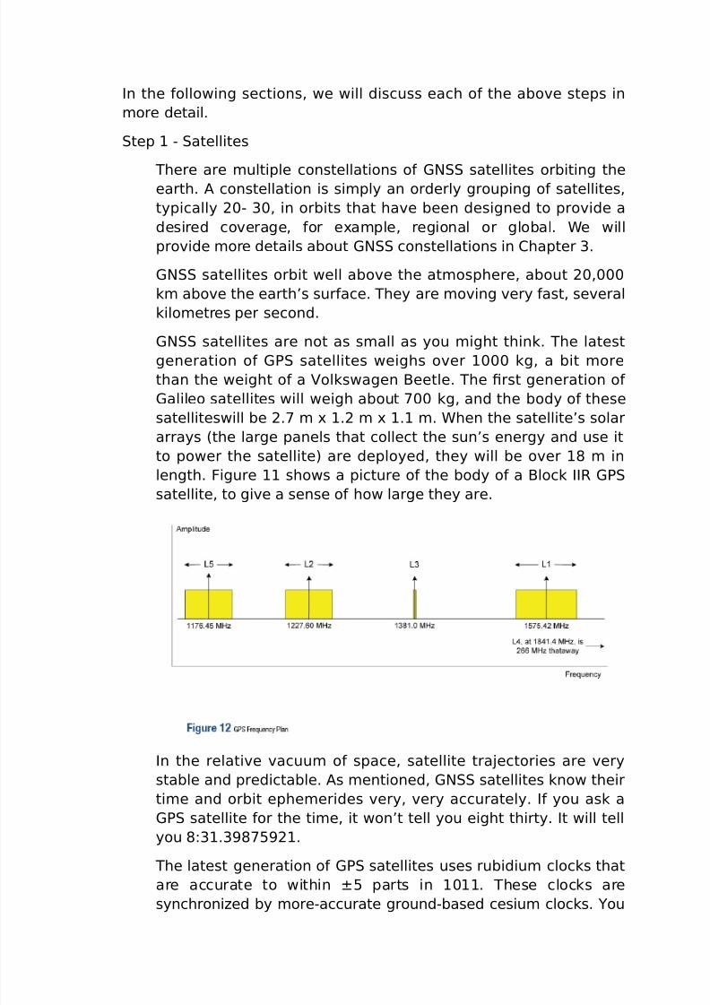
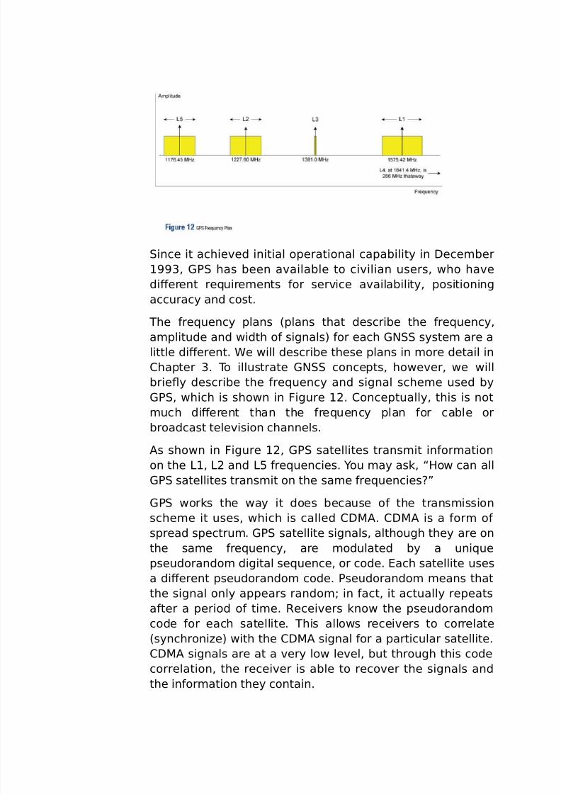
he &re5uency plans 8plans that describe the &re5uency,
a*plitude and width o& signals) &or each (N syste* are a
little diFerent. 4e will describe these plans in *ore detail in
#hapter 3. o illustrate (N concepts, howe%er, we will
briey describe the &re5uency and signal sche*e used by
(7, which is shown in igure 12. #onceptually, this is not
*uch diFerent than the &re5uency plan &or cable orbroadcast tele%ision channels.
"s shown in igure 12, (7 satellites trans*it in&or*ation
on the >1, >2 and >B &re5uencies. Dou *ay ask, “/ow can all
(7 satellites trans*it on the sa*e &re5uenciesM!
(7 works the way it does because o& the trans*ission
sche*e it uses, which is called #='". #='" is a &or* o&
spread spectru*. (7 satellite signals, although they are on
the sa*e &re5uency, are *odulated by a uni5ue
pseudorando* digital se5uence, or code. ach satellite uses
a diFerent pseudorando* code. 7seudorando* *eans that
the signal only appears rando*G in &act, it actually repeats
a&ter a period o& ti*e. @ecei%ers know the pseudorando*
code &or each satellite. his allows recei%ers to correlate
8synchroniHe) with the #='" signal &or a particular satellite.
#='" signals are at a %ery low le%el, but through this code
correlation, the recei%er is able to reco%er the signals and
the in&or*ation they contain.
7/26/2019 teori gnss
http://slidepdf.com/reader/full/teori-gnss 16/73
o illustrate, consider listening to a person in a noiseC0lled
roo*. 'any con%ersations are taking place, but each
con%ersation is in a diFerent language. Dou are able
understand the person because you know the language
they are speaking. I& you are *ultilingual, you will be able tounderstand what other people are saying too. #='" is a lot
like this.
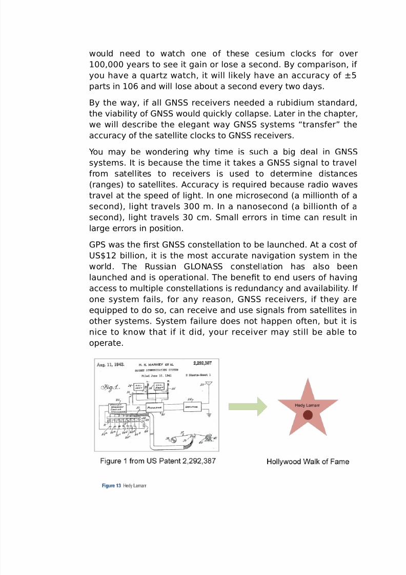
Dou *ight be interested to learn that /edy >a*arr, "ustrianC
born "*erican scientist and actress, coCin%ented an early
&or* o& spreadCspectru* co**unications technology. ?n
"ugust 11, 12, she and her coCworker, (eorge "ntheil,
were granted 9.. 7atent 2,22,3J;. 9nbelie%ably, >a*arr
shi&ted careers and went on to *ake 1J 0l*s &ro* 1< to
1, but the concepts co%ered in her patent contributed tothe de%elop*ent o& today’s spread spectru*
co**unications.
(7 operates in a &re5uency band re&erred to as the >Cband,
a portion o& the radio spectru* between 1 and 2 (/H. >C
band was chosen &or se%eral reasons, including:
i*pli0cation o& antenna design. I& the &re5uency had
been *uch higher, user antennas *ay ha%e had to be a
bit *ore co*ple-. Ionospheric delay is *ore signi0cant at lower &re5uencies.
4e’ll talk *ore about ionospheric delay in tep 2 C
7ropagation.
-cept through a %acuu*, the speed o& light is lower at
lower &re5uencies, as e%ident by the separation o& the
colours in light by a pris*. Dou *ay ha%e thought the
speed o& light was a constant at 2,;2,BJ *etres per
second. It is actually 2,;2,BJ *etres per second in a
%acuu*, but through air or any other *ediu*, it is less.
he coding sche*e re5uires a high bandwidth, which was
not a%ailable in e%ery &re5uency band.
he &re5uency band was chosen to *ini*iHe the eFect
that weather has on (7 signal propagation.
>1 trans*its a na%igation *essage, the coarse ac5uisition
#O" code 8&reely a%ailable to the public) and an encrypted
precision 87) code, called the 78D) code 8restricted access).
7/26/2019 teori gnss
http://slidepdf.com/reader/full/teori-gnss 17/73
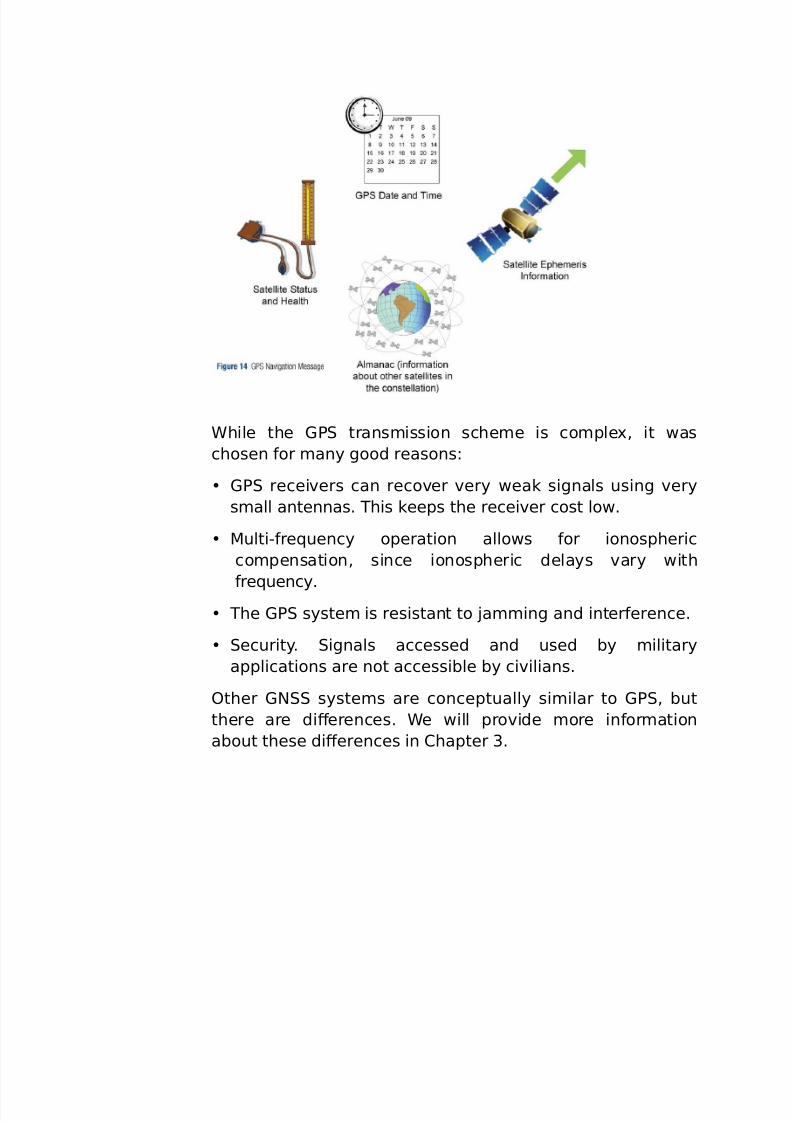
he na%igation *essage is a low bit rate *essage that
includes the &ollowing in&or*ation:
(7 date and ti*e.
atellite status and health. I& the satellite is ha%ingproble*s or its orbit is being adEusted, it will not be
usable. 4hen this happens, the satellite will trans*it the
outCo&Cser%ice *essage.
atellite ephe*eris data, which allows the recei%er to
calculate the satellite’s position. his in&or*ation is
accurate to *any, *any deci*al places. @ecei%ers can
deter*ine e-actly where the satellite was when it
trans*itted its ti*e.
"l*anac, which contains in&or*ation and status &or all
(7 satellites, so recei%ers know which satellites are
a%ailable &or tracking. ?n start up, a recei%er will reco%er
this “al*anac.! he al*anac consists o& coarse orbit and
status in&or*ation &or each satellite in the constellation.
he 78D) code is &or *ilitary use. It pro%ides better
inter&erence reEection than the #O" code, which *akes
*ilitary (7 *ore robust than ci%ilian (7. he >2
&re5uency trans*its the 78D) code and, on newer (7satellites, it also trans*its the #O" code 8re&erred to as >2#),
pro%iding a second publicly a%ailable code to ci%ilian users.
"lthough the in&or*ation in the 78D) code is not accessible
to e%eryone, cle%er people ha%e 0gured out ways to use the
>2 carrier and code, without knowing how it is coded.
7/26/2019 teori gnss
http://slidepdf.com/reader/full/teori-gnss 18/73
4hile the (7 trans*ission sche*e is co*ple-, it was
chosen &or *any good reasons:
(7 recei%ers can reco%er %ery weak signals using %ery
s*all antennas. his keeps the recei%er cost low.
'ultiC&re5uency operation allows &or ionospheric
co*pensation, since ionospheric delays %ary with
&re5uency. he (7 syste* is resistant to Ea**ing and inter&erence.
ecurity. ignals accessed and used by *ilitary
applications are not accessible by ci%ilians.
?ther (N syste*s are conceptually si*ilar to (7, but
there are diFerences. 4e will pro%ide *ore in&or*ation
about these diFerences in #hapter 3.
7/26/2019 teori gnss
http://slidepdf.com/reader/full/teori-gnss 19/73
atellite rrors
atellite errors include ephe*eride and clock errors. hese
satellite errors are %ery, %ery s*all, but keep in *ind that in
one nanosecond, light tra%els 3< centi*etres.
atellite >i&eti*es
(N satellites don’t last &ore%er. o*eti*es they are
phased out with newer *odels that ha%e new signals or
i*pro%ed ti*e keeping. o*eti*es (N satellites do &ail
and, i& they can’t be restored, are per*anently re*o%ed
&ro* ser%ice.
atellite #orrections
arth stations continuously *onitor the satellites andregularly adEust their ti*e and orbit in&or*ation, to keep this
broadcasted in&or*ation highly accurate. I& a satellite’s orbit
dri&ts outside the operating li*its, it *ay be taken out o&
ser%ice, and its orbit adEusted using s*all rocket boosters.
In our stepCbyCstep illustration o& (N, the radio signals
ha%e le&t the satellite antenna and are hurtling earthbound
at the speed o& light.
tep 2C 7ropagation
7/26/2019 teori gnss
http://slidepdf.com/reader/full/teori-gnss 20/73
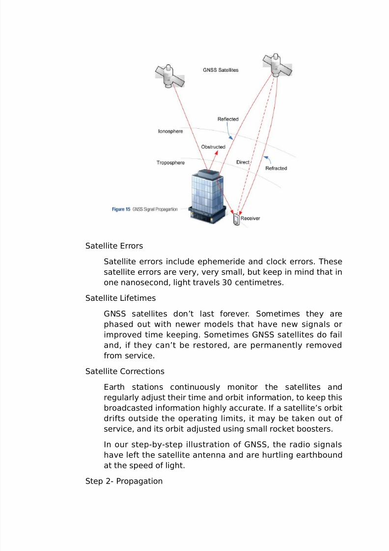
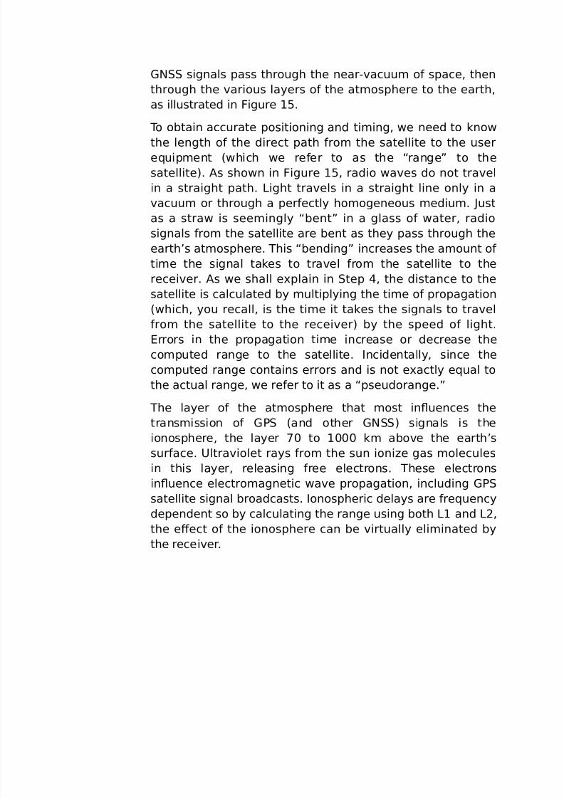
(N signals pass through the nearC%acuu* o& space, then
through the %arious layers o& the at*osphere to the earth,
as illustrated in igure 1B.
o obtain accurate positioning and ti*ing, we need to know
the length o& the direct path &ro* the satellite to the usere5uip*ent 8which we re&er to as the “range! to the
satellite). "s shown in igure 1B, radio wa%es do not tra%el
in a straight path. >ight tra%els in a straight line only in a
%acuu* or through a per&ectly ho*ogeneous *ediu*. Pust
as a straw is see*ingly “bent! in a glass o& water, radio
signals &ro* the satellite are bent as they pass through the
earth’s at*osphere. his “bending! increases the a*ount o&
ti*e the signal takes to tra%el &ro* the satellite to the
recei%er. "s we shall e-plain in tep , the distance to thesatellite is calculated by *ultiplying the ti*e o& propagation
8which, you recall, is the ti*e it takes the signals to tra%el
&ro* the satellite to the recei%er) by the speed o& light.
rrors in the propagation ti*e increase or decrease the
co*puted range to the satellite. Incidentally, since the
co*puted range contains errors and is not e-actly e5ual to
the actual range, we re&er to it as a “pseudorange.!
he layer o& the at*osphere that *ost inuences the
trans*ission o& (7 8and other (N) signals is theionosphere, the layer ;< to 1<<< k* abo%e the earth’s
sur&ace. 9ltra%iolet rays &ro* the sun ioniHe gas *olecules
in this layer, releasing &ree electrons. hese electrons
inuence electro*agnetic wa%e propagation, including (7
satellite signal broadcasts. Ionospheric delays are &re5uency
dependent so by calculating the range using both >1 and >2,
the eFect o& the ionosphere can be %irtually eli*inated by
the recei%er.
7/26/2019 teori gnss
http://slidepdf.com/reader/full/teori-gnss 21/73
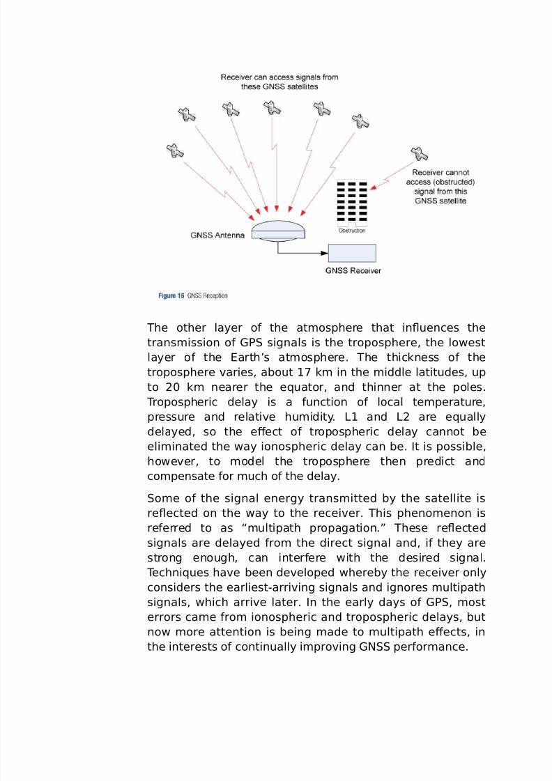
he other layer o& the at*osphere that inuences the
trans*ission o& (7 signals is the troposphere, the lowest
layer o& the arth’s at*osphere. he thickness o& the
troposphere %aries, about 1; k* in the *iddle latitudes, up
to 2< k* nearer the e5uator, and thinner at the poles.
ropospheric delay is a &unction o& local te*perature,
pressure and relati%e hu*idity. >1 and >2 are e5ually
delayed, so the eFect o& tropospheric delay cannot be
eli*inated the way ionospheric delay can be. It is possible,
howe%er, to *odel the troposphere then predict and
co*pensate &or *uch o& the delay.
o*e o& the signal energy trans*itted by the satellite is
reected on the way to the recei%er. his pheno*enon is
re&erred to as “*ultipath propagation.! hese reected
signals are delayed &ro* the direct signal and, i& they arestrong enough, can inter&ere with the desired signal.
echni5ues ha%e been de%eloped whereby the recei%er only
considers the earliestCarri%ing signals and ignores *ultipath
signals, which arri%e later. In the early days o& (7, *ost
errors ca*e &ro* ionospheric and tropospheric delays, but
now *ore attention is being *ade to *ultipath eFects, in
the interests o& continually i*pro%ing (N per&or*ance.
7/26/2019 teori gnss
http://slidepdf.com/reader/full/teori-gnss 22/73
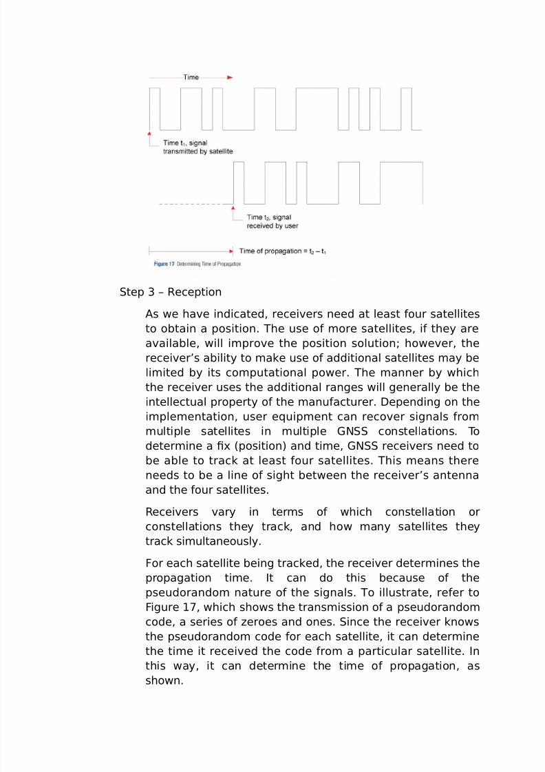
tep 3 6 @eception
"s we ha%e indicated, recei%ers need at least &our satellites
to obtain a position. he use o& *ore satellites, i& they are
a%ailable, will i*pro%e the position solutionG howe%er, the
recei%er’s ability to *ake use o& additional satellites *ay be
li*ited by its co*putational power. he *anner by which
the recei%er uses the additional ranges will generally be the
intellectual property o& the *anu&acturer. =epending on thei*ple*entation, user e5uip*ent can reco%er signals &ro*
*ultiple satellites in *ultiple (N constellations. o
deter*ine a 0- 8position) and ti*e, (N recei%ers need to
be able to track at least &our satellites. his *eans there
needs to be a line o& sight between the recei%er’s antenna
and the &our satellites.
@ecei%ers %ary in ter*s o& which constellation or
constellations they track, and how *any satellites they
track si*ultaneously.
or each satellite being tracked, the recei%er deter*ines the
propagation ti*e. It can do this because o& the
pseudorando* nature o& the signals. o illustrate, re&er to
igure 1;, which shows the trans*ission o& a pseudorando*
code, a series o& Heroes and ones. ince the recei%er knows
the pseudorando* code &or each satellite, it can deter*ine
the ti*e it recei%ed the code &ro* a particular satellite. In
this way, it can deter*ine the ti*e o& propagation, as
shown.
7/26/2019 teori gnss
http://slidepdf.com/reader/full/teori-gnss 23/73
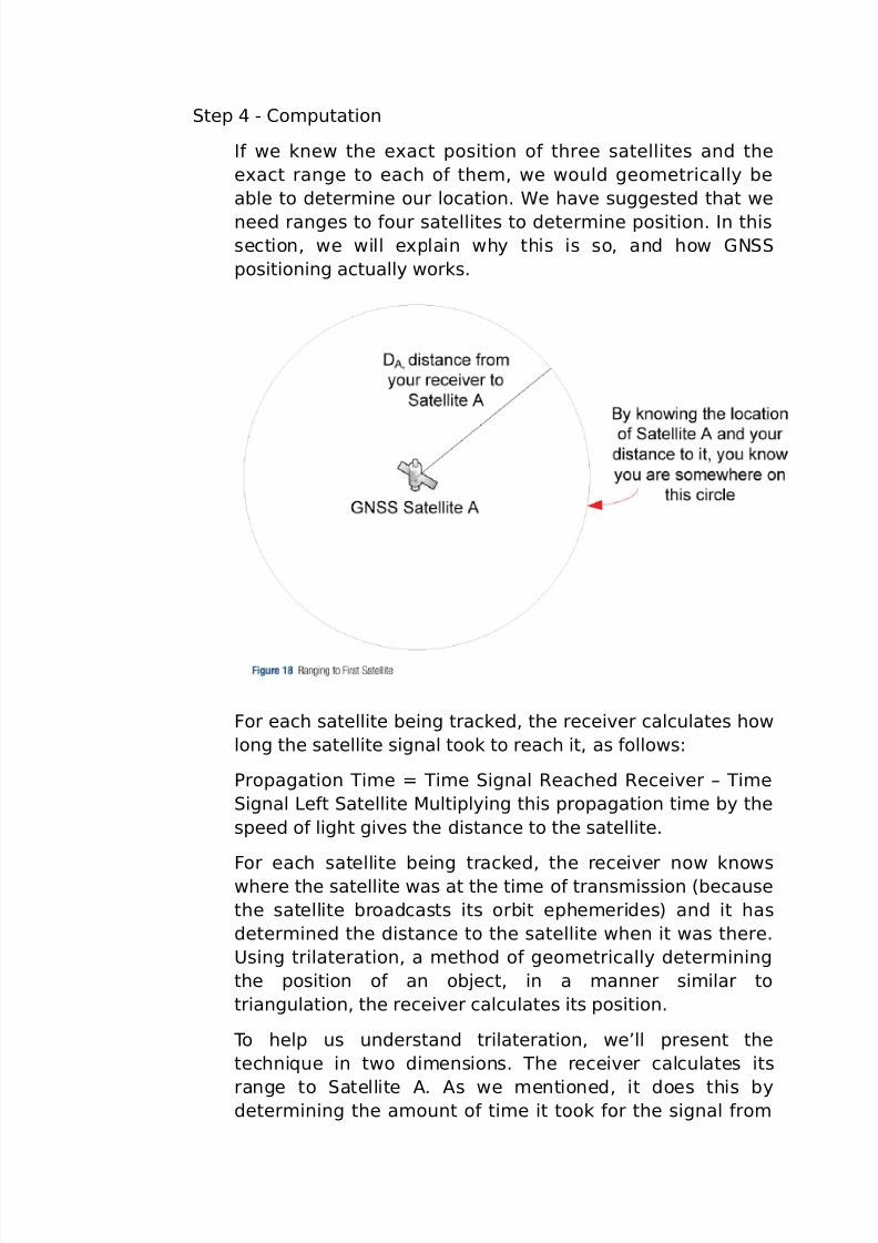
tep C #o*putation
I& we knew the e-act position o& three satellites and the
e-act range to each o& the*, we would geo*etrically be
able to deter*ine our location. 4e ha%e suggested that we
need ranges to &our satellites to deter*ine position. In thissection, we will e-plain why this is so, and how (N
positioning actually works.
or each satellite being tracked, the recei%er calculates how
long the satellite signal took to reach it, as &ollows:
7ropagation i*e Q i*e ignal @eached @ecei%er 6 i*e
ignal >e&t atellite 'ultiplying this propagation ti*e by the
speed o& light gi%es the distance to the satellite.
or each satellite being tracked, the recei%er now knowswhere the satellite was at the ti*e o& trans*ission 8because
the satellite broadcasts its orbit ephe*erides) and it has
deter*ined the distance to the satellite when it was there.
9sing trilateration, a *ethod o& geo*etrically deter*ining
the position o& an obEect, in a *anner si*ilar to
triangulation, the recei%er calculates its position.
o help us understand trilateration, we’ll present the
techni5ue in two di*ensions. he recei%er calculates its
range to atellite ". "s we *entioned, it does this bydeter*ining the a*ount o& ti*e it took &or the signal &ro*
7/26/2019 teori gnss
http://slidepdf.com/reader/full/teori-gnss 24/73
atellite " to arri%e at the recei%er, and *ultiplying this ti*e
by the speed o& light. atellite " co**unicated its location
8deter*ined &ro* the satellite orbit ephe*erides and ti*e)
to the recei%er, so the recei%er knows it is so*ewhere on a
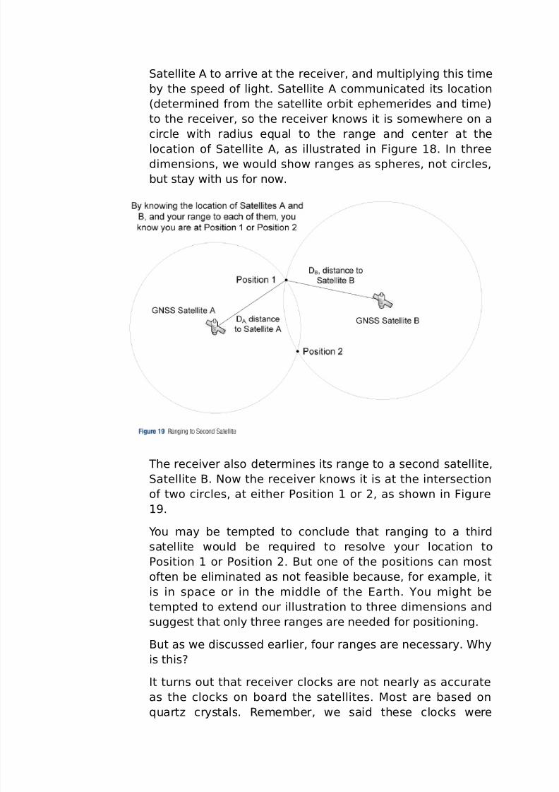
circle with radius e5ual to the range and center at thelocation o& atellite ", as illustrated in igure 1J. In three
di*ensions, we would show ranges as spheres, not circles,
but stay with us &or now.
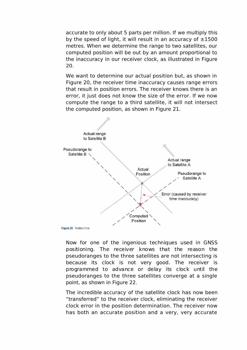
he recei%er also deter*ines its range to a second satellite,
atellite $. Now the recei%er knows it is at the intersection
o& two circles, at either 7osition 1 or 2, as shown in igure
1.
Dou *ay be te*pted to conclude that ranging to a third
satellite would be re5uired to resol%e your location to
7osition 1 or 7osition 2. $ut one o& the positions can *ost
o&ten be eli*inated as not &easible because, &or e-a*ple, it
is in space or in the *iddle o& the arth. Dou *ight be
te*pted to e-tend our illustration to three di*ensions and
suggest that only three ranges are needed &or positioning.
$ut as we discussed earlier, &our ranges are necessary. 4hy
is thisM
It turns out that recei%er clocks are not nearly as accurate
as the clocks on board the satellites. 'ost are based on5uartH crystals. @e*e*ber, we said these clocks were
7/26/2019 teori gnss
http://slidepdf.com/reader/full/teori-gnss 25/73
accurate to only about B parts per *illion. I& we *ultiply this
by the speed o& light, it will result in an accuracy o& K1B<<
*etres. 4hen we deter*ine the range to two satellites, our
co*puted position will be out by an a*ount proportional to
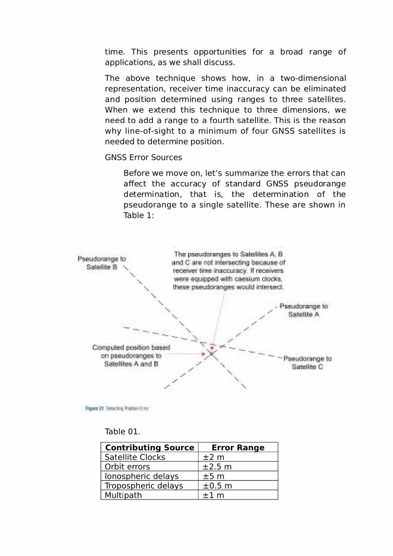
the inaccuracy in our recei%er clock, as illustrated in igure2<.
4e want to deter*ine our actual position but, as shown in
igure 2<, the recei%er ti*e inaccuracy causes range errors
that result in position errors. he recei%er knows there is an
error, it Eust does not know the siHe o& the error. I& we now
co*pute the range to a third satellite, it will not intersect
the co*puted position, as shown in igure 21.
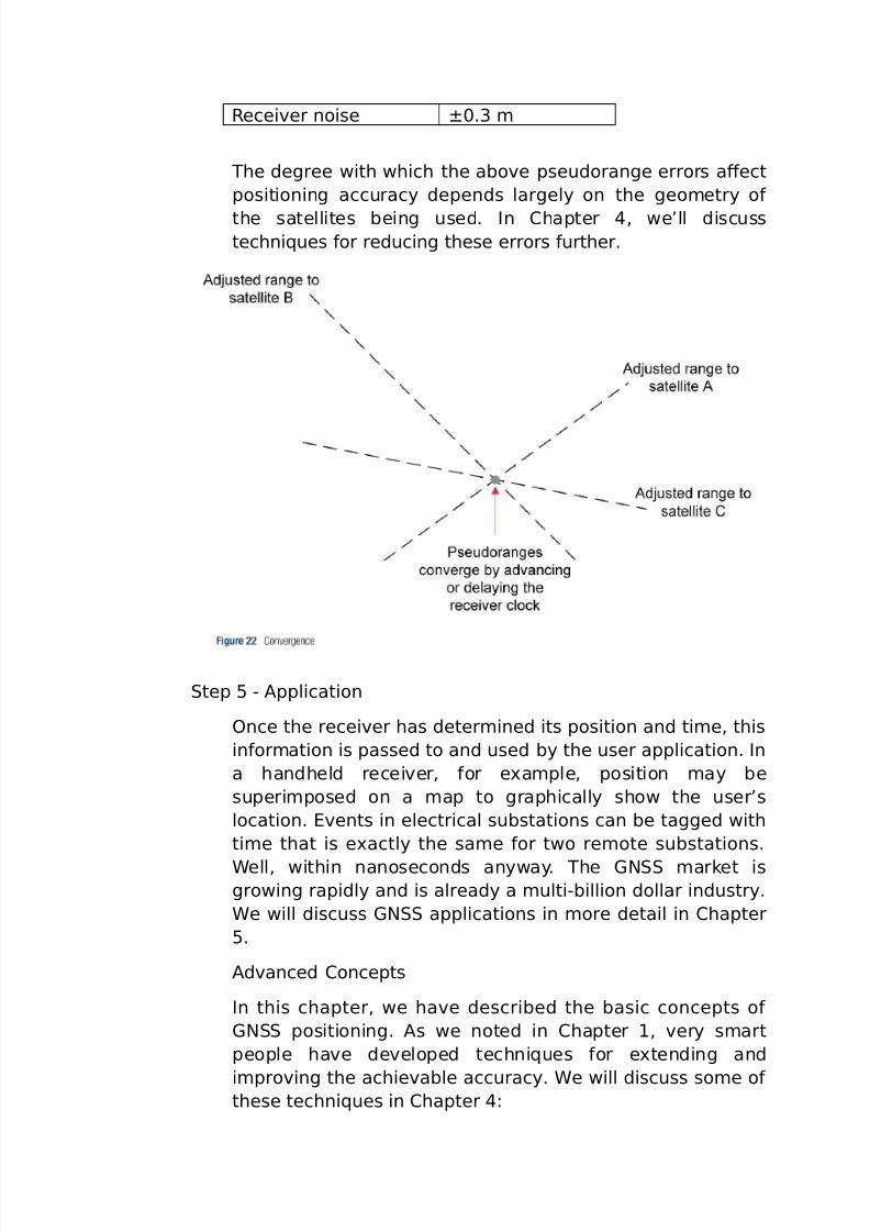
Now &or one o& the ingenious techni5ues used in (N
positioning. he recei%er knows that the reason the
pseudoranges to the three satellites are not intersecting is
because its clock is not %ery good. he recei%er is
progra**ed to ad%ance or delay its clock until the
pseudoranges to the three satellites con%erge at a single
point, as shown in igure 22.
he incredible accuracy o& the satellite clock has now been
“trans&erred! to the recei%er clock, eli*inating the recei%er
clock error in the position deter*ination. he recei%er nowhas both an accurate position and a %ery, %ery accurate
7/26/2019 teori gnss
http://slidepdf.com/reader/full/teori-gnss 26/73
ti*e. his presents opportunities &or a broad range o&
applications, as we shall discuss.
he abo%e techni5ue shows how, in a twoCdi*ensional
representation, recei%er ti*e inaccuracy can be eli*inated
and position deter*ined using ranges to three satellites.4hen we e-tend this techni5ue to three di*ensions, we
need to add a range to a &ourth satellite. his is the reason
why lineCo&Csight to a *ini*u* o& &our (N satellites is
needed to deter*ine position.
(N rror ources
$e&ore we *o%e on, let’s su**ariHe the errors that can
aFect the accuracy o& standard (N pseudorange
deter*ination, that is, the deter*ination o& thepseudorange to a single satellite. hese are shown in
able 1:
able <1.
Contributing Source Error Rangeatellite #locks K2 *?rbit errors K2.B *Ionospheric delays KB *
ropospheric delays K<.B *'ultipath K1 *
7/26/2019 teori gnss
http://slidepdf.com/reader/full/teori-gnss 27/73
@ecei%er noise K<.3 *
he degree with which the abo%e pseudorange errors aFect
positioning accuracy depends largely on the geo*etry o&
the satellites being used. In #hapter , we’ll discusstechni5ues &or reducing these errors &urther.
tep B C "pplication
?nce the recei%er has deter*ined its position and ti*e, this
in&or*ation is passed to and used by the user application. In
a handheld recei%er, &or e-a*ple, position *ay be
superi*posed on a *ap to graphically show the user’s
location. %ents in electrical substations can be tagged with
ti*e that is e-actly the sa*e &or two re*ote substations.
4ell, within nanoseconds anyway. he (N *arket isgrowing rapidly and is already a *ultiCbillion dollar industry.
4e will discuss (N applications in *ore detail in #hapter
B.
"d%anced #oncepts
In this chapter, we ha%e described the basic concepts o&
(N positioning. "s we noted in #hapter 1, %ery s*art
people ha%e de%eloped techni5ues &or e-tending and
i*pro%ing the achie%able accuracy. 4e will discuss so*e o& these techni5ues in #hapter :
7/26/2019 teori gnss
http://slidepdf.com/reader/full/teori-gnss 28/73
=ilution o& 7recision: he geo*etric arrange*ent o&
satellites, as they are presented to the recei%er, aFects
the accuracy o& the position and ti*e solution. @ecei%ers
will use the signals &ro* satellites to *ini*iHe this
“dilution o& precision.! =iFerential (N: " techni5ue whereby a base station at
a precisely known location works backwards to deter*ine
errors in ranges to a%ailable (7 satellites, then trans*its
range corrections to other stations. his techni5ue is used
to eli*inate or reduce satellite errors and at*ospheric
delays.
#arrierCbased echni5ues: he positioning techni5ue weha%e described in this chapter is re&erred to as a codeC
based techni5ue because the recei%er correlates with and
uses the pseudorando* codes trans*itted by &our or
*ore satellites to deter*ine its position and ti*e. his
results in positioning accuracies o& a &ew *etres. or
applications such as sur%eying, higher accuracies are
re5uired. #arrierCbased techni5ues such as @ealCi*e
Rine*atic 8@R) ha%e been de%eloped that can pro%ide
positions that are orders o& *agnitude *ore accuratethan the codeCbased (N we ha%e discussed in this
chapter.
Inertial Na%igation yste*s: In *obile applications, line o&
sight to (N satellites *ay be interrupted when, &or
e-a*ple, a %ehicle is passing through a tunnel or builtCup
urban area. (N recei%ers *ay be integrated with an
inertial na%igation syste* to bridge through periods
where (N ser%ice is not a%ailable.
#losing @e*arks
his has been a tough chapter and we’re pleased you
perse%ered through the basics o& (N positioning. #hapter
3 pro%ides additional in&or*ation about the (N
constellations that ha%e been i*ple*ented or are planned.
#hapter discusses ad%anced (N concepts, and #hapter
B discusses e5uip*ent and applications 6 how the si*ple
outputs o& this incredible technology are being used.
7/26/2019 teori gnss
http://slidepdf.com/reader/full/teori-gnss 29/73
“he dinosaurs beca*e e-tinct because they didn’t ha%e a space
progra*.! >arry Ni%en, "*erican science 0ction author.
>arry Ni%en is suggesting is that i& the dinosaurs had had a space
progra*, they could ha%e intercepted and deected the asteroid that
so*e think *ay ha%e hit the earth and led to the e-tinction o& the
dinosaurs.
7/26/2019 teori gnss
http://slidepdf.com/reader/full/teori-gnss 30/73
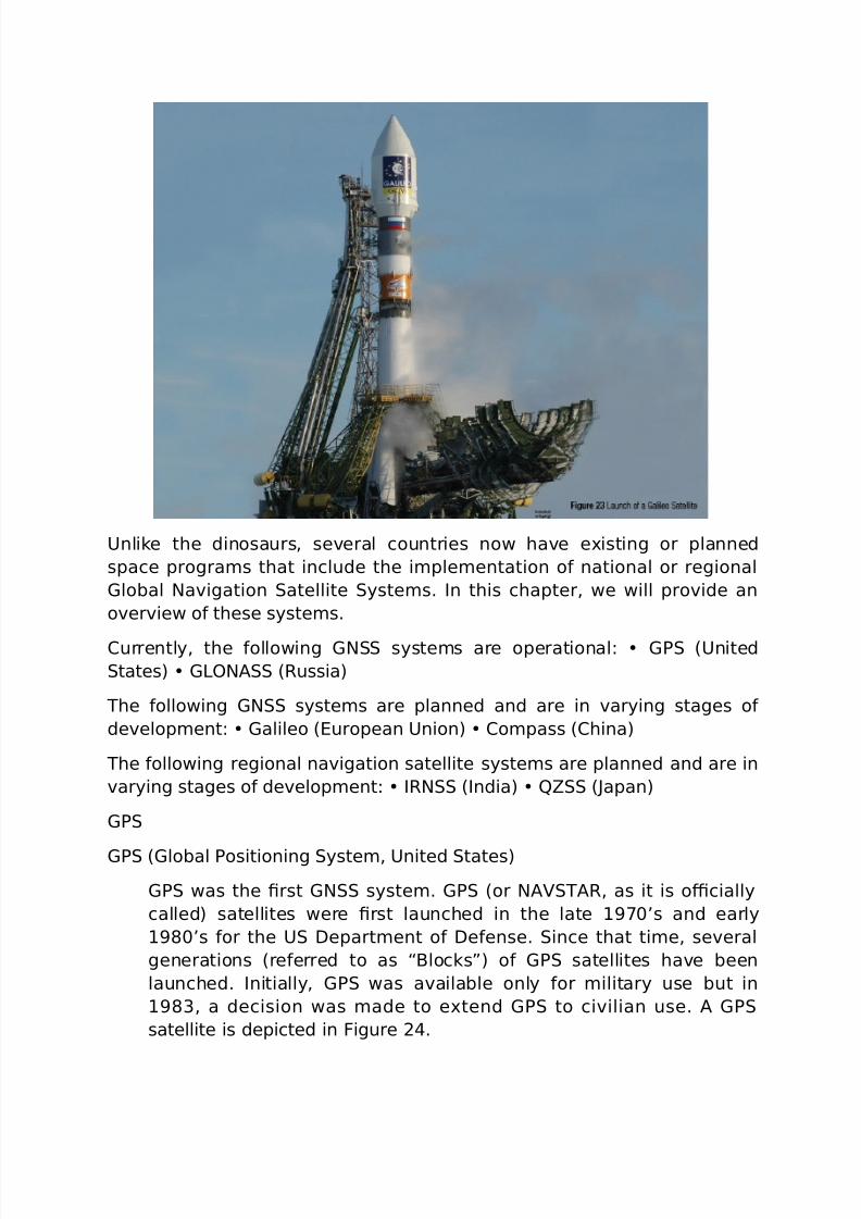
9nlike the dinosaurs, se%eral countries now ha%e e-isting or planned
space progra*s that include the i*ple*entation o& national or regional
(lobal Na%igation atellite yste*s. In this chapter, we will pro%ide an
o%er%iew o& these syste*s.
#urrently, the &ollowing (N syste*s are operational: (7 89nited
tates) (>?N" 8@ussia)
he &ollowing (N syste*s are planned and are in %arying stages o&
de%elop*ent: (alileo 8uropean 9nion) #o*pass 8#hina)
he &ollowing regional na%igation satellite syste*s are planned and are in
%arying stages o& de%elop*ent: I@N 8India) ST 8Papan)
(7
(7 8(lobal 7ositioning yste*, 9nited tates)
(7 was the 0rst (N syste*. (7 8or N""@, as it is o+cially
called) satellites were 0rst launched in the late 1;<’s and early
1J<’s &or the 9 =epart*ent o& =e&ense. ince that ti*e, se%eral
generations 8re&erred to as “$locks!) o& (7 satellites ha%e been
launched. Initially, (7 was a%ailable only &or *ilitary use but in
1J3, a decision was *ade to e-tend (7 to ci%ilian use. " (7
satellite is depicted in igure 2.
7/26/2019 teori gnss
http://slidepdf.com/reader/full/teori-gnss 31/73
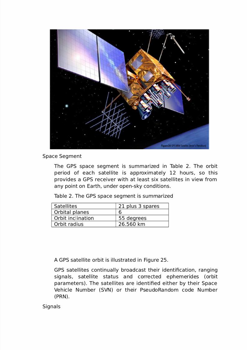
pace eg*ent
he (7 space seg*ent is su**ariHed in able 2. he orbit
period o& each satellite is appro-i*ately 12 hours, so this
pro%ides a (7 recei%er with at least si- satellites in %iew &ro*
any point on arth, under openCsky conditions.
able 2. he (7 space seg*ent is su**ariHed
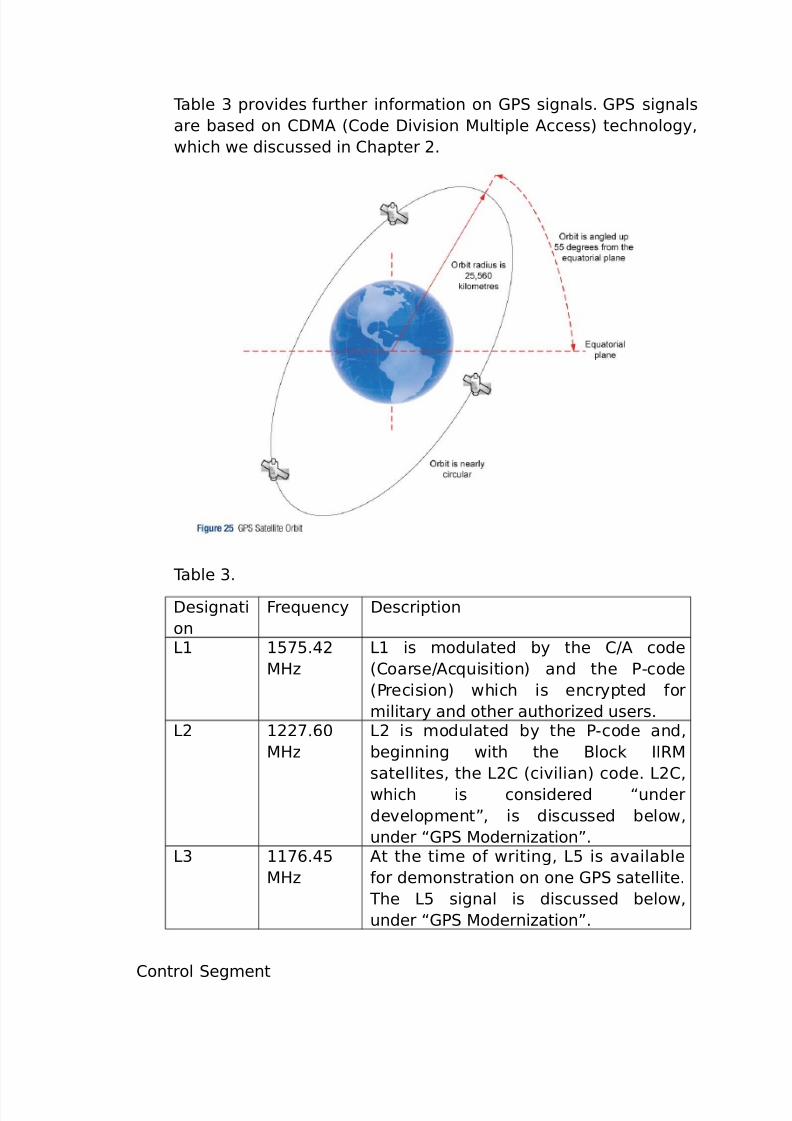
atellites 21 plus 3 spares?rbital planes A?rbit inclination BB degrees?rbit radius 2A.BA< k*
" (7 satellite orbit is illustrated in igure 2B.
(7 satellites continually broadcast their identi0cation, ranging
signals, satellite status and corrected ephe*erides 8orbit
para*eters). he satellites are identi0ed either by their pace
ehicle Nu*ber 8N) or their 7seudo@ando* code Nu*ber
87@N).
ignals
7/26/2019 teori gnss
http://slidepdf.com/reader/full/teori-gnss 32/73
able 3 pro%ides &urther in&or*ation on (7 signals. (7 signals
are based on #='" 8#ode =i%ision 'ultiple "ccess) technology,
which we discussed in #hapter 2.
able 3.
=esignati
on
re5uency =escription
>1 1B;B.2
'/H
>1 is *odulated by the #O" code
8#oarseO"c5uisition) and the 7Ccode
87recision) which is encrypted &or
*ilitary and other authoriHed users.>2 122;.A<
'/H
>2 is *odulated by the 7Ccode and,
beginning with the $lock II@'
satellites, the >2# 8ci%ilian) code. >2#,
which is considered “under
de%elop*ent!, is discussed below,
under “(7 'oderniHation!.>3 11;A.B
'/H
"t the ti*e o& writing, >B is a%ailable
&or de*onstration on one (7 satellite.
he >B signal is discussed below,
under “(7 'oderniHation!.
#ontrol eg*ent
7/26/2019 teori gnss
http://slidepdf.com/reader/full/teori-gnss 33/73
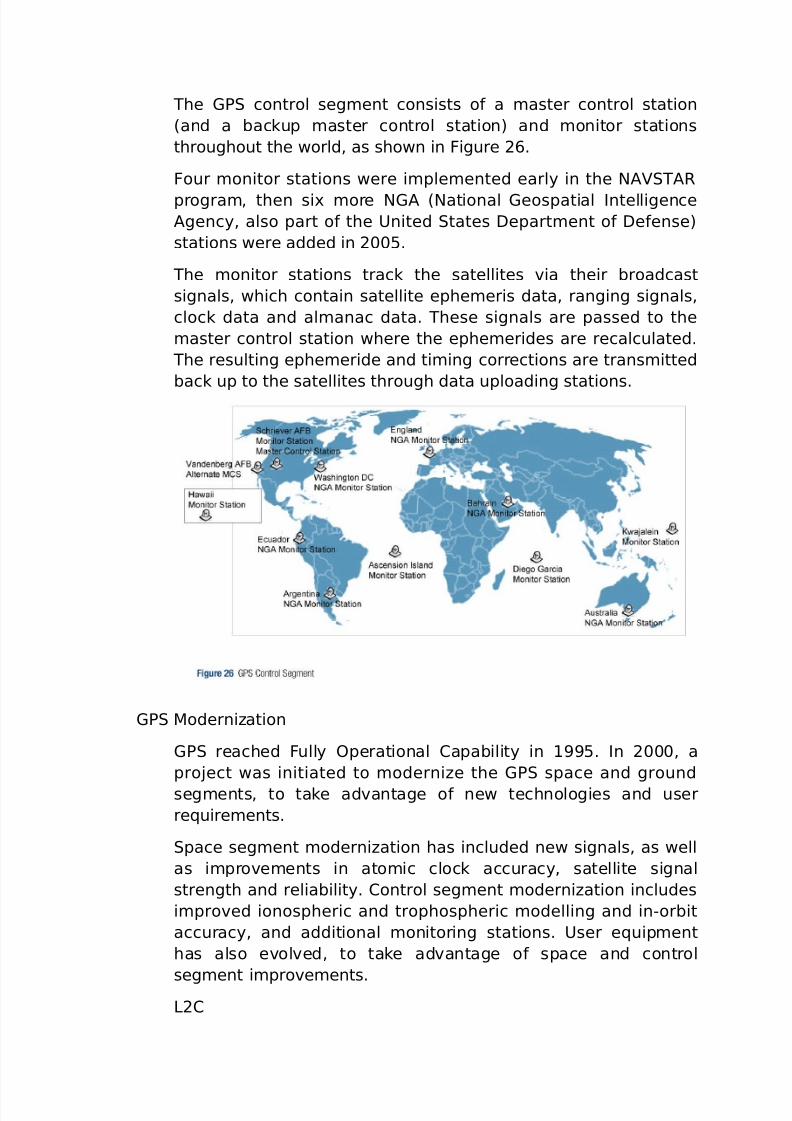
he (7 control seg*ent consists o& a *aster control station
8and a backup *aster control station) and *onitor stations
throughout the world, as shown in igure 2A.
our *onitor stations were i*ple*ented early in the N""@
progra*, then si- *ore N(" 8National (eospatial Intelligence"gency, also part o& the 9nited tates =epart*ent o& =e&ense)
stations were added in 2<<B.
he *onitor stations track the satellites %ia their broadcast
signals, which contain satellite ephe*eris data, ranging signals,
clock data and al*anac data. hese signals are passed to the
*aster control station where the ephe*erides are recalculated.
he resulting ephe*eride and ti*ing corrections are trans*itted
back up to the satellites through data uploading stations.
(7 'oderniHation
(7 reached ully ?perational #apability in 1B. In 2<<<, a
proEect was initiated to *oderniHe the (7 space and ground
seg*ents, to take ad%antage o& new technologies and user
re5uire*ents.
pace seg*ent *oderniHation has included new signals, as well
as i*pro%e*ents in ato*ic clock accuracy, satellite signal
strength and reliability. #ontrol seg*ent *oderniHation includes
i*pro%ed ionospheric and trophospheric *odelling and inCorbit
accuracy, and additional *onitoring stations. 9ser e5uip*ent
has also e%ol%ed, to take ad%antage o& space and control
seg*ent i*pro%e*ents.>2#
7/26/2019 teori gnss
http://slidepdf.com/reader/full/teori-gnss 34/73
he latest generation o& (7 satellites has the capability to
trans*it a new ci%ilian signal, designated >2#. ?nce
operational, >2# will ensure the accessibility o& two ci%ilian
codes. >2# will be easier &or the user seg*ent to track and
it will pro%ide i*pro%ed na%igation accuracy. It will alsopro%ide the ability to directly *easure and re*o%e the
ionospheric delay error &or a particular satellite, using the
ci%ilian signals on both >1 and >2.
>B 8a&ety o& >i&e)
9nited tates has started i*ple*enting a third ci%il (7
&re5uency 8>B) at 11;A.B '/H. he 0rst N""@ (7
satellite to trans*it >B, on a de*onstration basis, was
launched in 2<<.
he bene0ts o& the >B signal include *eeting the
re5uire*ents &or critical sa&etyCo&Cli&e applications such as
that needed &or ci%il a%iation, and pro%iding:
I*pro%ed ionospheric correction.
ignal redundancy.
I*pro%ed signal accuracy.
I*pro%ed inter&erence reEection.?ther
In addition to the new >2# and >B signals, (7 satellite
*oderniHation includes a new *ilitary signal and an
i*pro%ed >1# which will be backwards co*patible with >1
and which will pro%ide greater ci%ilian interoperability with
(alileo.
7/26/2019 teori gnss
http://slidepdf.com/reader/full/teori-gnss 35/73
(>?N"
(>?N" was de%eloped by the o%iet 9nion as an e-peri*ental
*ilitary co**unications syste* during the 1;<s. 4hen the #old4ar ended, the o%iet 9nion recogniHed that (>?N" had
co**ercial applications, through the syste*’s ability to trans*it
weather broadcasts, co**unications, na%igation and reconnaissance
data.
he 0rst (>?N" satellite was launched in 1J2 and the syste* was
declared &ully operational in 13. "&ter a period where (>?N"
per&or*ance declined, @ussia co**itted to bringing the syste* up to
the re5uired *ini*u* o& 1J acti%e satellites. he @ussian
go%ern*ent set 2<11 as the date &or &ull deploy*ent o& the 2C
satellite constellation and has ensured that the necessary 0nancial
support will be there to *eet this date.
7/26/2019 teori gnss
http://slidepdf.com/reader/full/teori-gnss 36/73
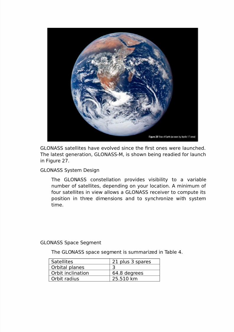
(>?N" satellites ha%e e%ol%ed since the 0rst ones were launched.
he latest generation, (>?N"C', is shown being readied &or launch
in igure 2;.
(>?N" yste* =esign
he (>?N" constellation pro%ides %isibility to a %ariable
nu*ber o& satellites, depending on your location. " *ini*u* o&
&our satellites in %iew allows a (>?N" recei%er to co*pute its
position in three di*ensions and to synchroniHe with syste*
ti*e.
(>?N" pace eg*ent
he (>?N" space seg*ent is su**ariHed in able .
atellites 21 plus 3 spares?rbital planes 3?rbit inclination A.J degrees?rbit radius 2B.B1< k*
7/26/2019 teori gnss
http://slidepdf.com/reader/full/teori-gnss 37/73
4hen co*plete, the (>?N" space seg*ent will consist o& 2
satellites in three orbital planes, with eight satellites per plane.
he (>?N" constellation geo*etry repeats about once e%ery
eight days. he orbit period o& each satellite is appro-i*ately
JO1; o& a sidereal day so that, a&ter eight sidereal days, the(>?N" satellites ha%e co*pleted e-actly 1; orbital
re%olutions.
ach orbital plane contains eight e5ually spaced satellites. ?ne
o& the satellites will be at the sa*e spot in the sky at the sa*e
sidereal ti*e each day.
he satellites are placed into no*inally circular orbits with target
inclinations o& A.J degrees and an orbital radius o& 2B,B1< k*,
about 1,<B< k* lower than (7 satellites.
he (>?N" satellite signal identi0es the satellite and includes:
7ositioning, %elocity and acceleration in&or*ation &or
co*puting satellite locations.
atellite health in&or*ation.
?Fset o& (>?N" ti*e &ro* 9# 89) U&or*erly o%iet 9nion
and now @ussiaV.
"l*anac o& all other (>?N" satellites.
“he arth was absolutely round . . . I ne%er knew what the word
Wround’ *eant until I saw arth &ro* space.! "le-ei >eono%,
o%iet astronaut, talking about his historic 1JB spacewalk.
(>?N" #ontrol eg*ent
he (>?N" control seg*ent consists o& the syste* control
center and a network o& co**and tracking stations across
@ussia. he (>?N" control seg*ent, si*ilar to that o& (7,
*onitors the status o& satellites, deter*ines the ephe*eride
corrections, and satellite clock oFsets with respect to (>?N"
ti*e and 9# 8#oordinated 9ni%ersal i*e). wice a day, it
uploads corrections to the satellites.
7/26/2019 teori gnss
http://slidepdf.com/reader/full/teori-gnss 38/73
(>?N" ignals
(>?N" satellites each trans*it on slightly diFerent >1 and >2
&re5uencies, with the 7Ccode 8/7 code) on both >1 and >2, and
the #O" code 87 code), on >1 8all satellites) and >2 8*ost
satellites). (>?N" satellites trans*it the sa*e code at
diFerent &re5uencies, a techni5ue known as ='", &or &re5uency
di%ision *ultiple access. Note that this is a diFerent techni5ue
&ro* that used by (7.
(>?N" signals ha%e the sa*e polariHation 8orientation o& the
electro*agnetic wa%es) as (7 signals, and ha%e co*parable
signal strength.
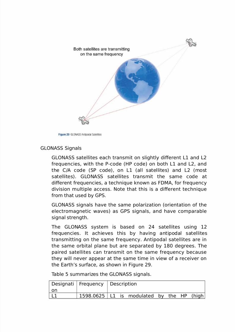
he (>?N" syste* is based on 2 satellites using 12
&re5uencies. It achie%es this by ha%ing antipodal satellitestrans*itting on the sa*e &re5uency. "ntipodal satellites are in
the sa*e orbital plane but are separated by 1J< degrees. he
paired satellites can trans*it on the sa*e &re5uency because
they will ne%er appear at the sa*e ti*e in %iew o& a recei%er on
the arth’s sur&ace, as shown in igure 2.
able B su**ariHes the (>?N" signals.
=esignati
on
re5uency =escription
>1 1BJ.<A2B >1 is *odulated by the /7 8high
7/26/2019 teori gnss
http://slidepdf.com/reader/full/teori-gnss 39/73
C
1A<.312B
'/H
precision) and the 7 8standard
precision) signals.
>2 122.3;B
C12B1.AJ;B
'/H
>2 is *odulated by the /7 and 7
signals. he 7 code is identical to thattrans*itted on >1.
(>?N" and (7
he use o& (>?N" in addition to (7, results in there being a
larger nu*ber o& satellites in the 0eld o& %iew, which has the
&ollowing bene0ts:
@educed signal ac5uisition ti*e
I*pro%ed position and ti*e accuracy
@eduction o& proble*s caused by obstructions such as
buildings and &oliage
I*pro%ed spatial distribution o& %isible satellites, resulting in
i*pro%ed dilution o& precision. 4e will say *ore about dilution o&
precision in #hapter .
o deter*ine a position in (7Conly *ode, a recei%er *ust track
a *ini*u* o& &our satellites. In co*bined (7O(>?N" *ode,
the recei%er *ust track 0%e satellites, at least one o& which *ustbe a (>?N" satellite, so the recei%er can deter*ine the
(7O(>?N" ti*e oFset.
4ith the a%ailability o& co*bined (7O(>?N" recei%ers, users
ha%e access to a satellite co*bined syste* with o%er <
satellites. 7er&or*ance in urban canyons and other locations with
restricted %isibility i*pro%es as *ore satellites are accessible by
the recei%er.
7/26/2019 teori gnss
http://slidepdf.com/reader/full/teori-gnss 40/73
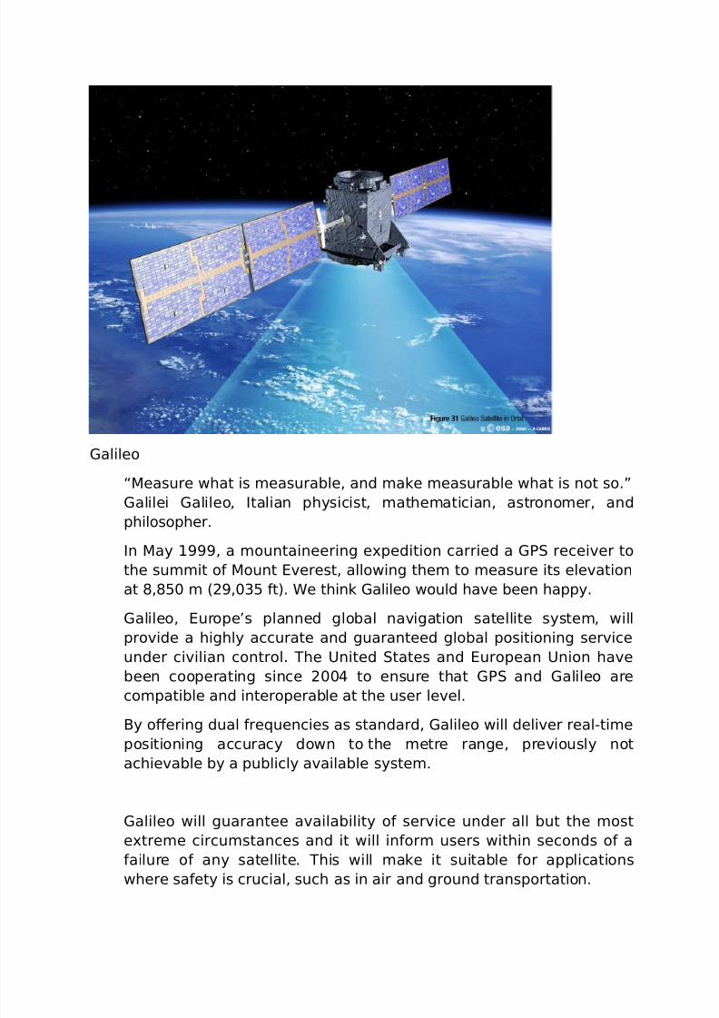
(alileo
“'easure what is *easurable, and *ake *easurable what is not so.!
(alilei (alileo, Italian physicist, *athe*atician, astrono*er, and
philosopher.
In 'ay 1, a *ountaineering e-pedition carried a (7 recei%er to
the su**it o& 'ount %erest, allowing the* to *easure its ele%ation
at J,JB< * 82,<3B &t). 4e think (alileo would ha%e been happy.
(alileo, urope’s planned global na%igation satellite syste*, will
pro%ide a highly accurate and guaranteed global positioning ser%ice
under ci%ilian control. he 9nited tates and uropean 9nion ha%e
been cooperating since 2<< to ensure that (7 and (alileo are
co*patible and interoperable at the user le%el.
$y oFering dual &re5uencies as standard, (alileo will deli%er realCti*e
positioning accuracy down to the *etre range, pre%iously not
achie%able by a publicly a%ailable syste*.
(alileo will guarantee a%ailability o& ser%ice under all but the *ost
e-tre*e circu*stances and it will in&or* users within seconds o& a
&ailure o& any satellite. his will *ake it suitable &or applications
where sa&ety is crucial, such as in air and ground transportation.
7/26/2019 teori gnss
http://slidepdf.com/reader/full/teori-gnss 41/73
he 0rst e-peri*ental (alileo satellite, part o& the (alileo yste* est
$ed 8($) was launched in =ece*ber 2<<B. he purpose o& this
e-peri*ental satellite is to characteriHe critical (alileo technologies,
which are already in de%elop*ent under uropean pace "gency
8") contracts. our operational satellites are planned to belaunched in the 2<1<C2<12 ti*e &ra*e to %alidate the basic (alileo
space and ground seg*ent. ?nce this InC?rbit alidation 8I?) phase
has been co*pleted, the re*aining satellites will be launched, with
plans to reach ull ?perational #apability 8?#) likely so*eti*e a&ter
2<13.
yste* =esign
he (alileo space seg*ent is su**ariHed in able A. ?nce the
constellation is operational, (alileo na%igation signals will
pro%ide co%erage at all latitudes. he large nu*ber o& satellites,
together with the opti*iHation o& the constellation and the
a%ailability o& the three acti%e spare satellites, will ensure that
the loss o& one satellite has no discernable eFect on the user
seg*ent.
able A. he (">I>? space seg*ent is su**ariHed.
atellites 2; operational and three
acti%e spares
?rbital planes 3?rbit inclination BA degrees?rbit radius 23.A1A k*
atellites
wo (alileo #ontrol #entres 8(##), to be located in urope, will
control the satellites. =ata reco%ered by a global network o&
twenty (alileo ensor tations 8() will be sent to the (##
through a redundant co**unications network. he (##s will usethe data &ro* the ensor tations to co*pute integrity
in&or*ation and to synchroniHe satellite ti*e with ground station
clocks. #ontrol #entres will co**unicate with the satellites
through uplink stations, which will be installed around the world.
able ;.
er%ice =escriptionree ?pen er%ice
8?)
7ro%ides positioning, na%igation and
precise ti*ing ser%ice. It will be a%ailable
&or use by any person with a (alileo

7/26/2019 teori gnss
http://slidepdf.com/reader/full/teori-gnss 42/73
recei%er. No authorisation will be re5uired
to access this ser%ice. (alileo is e-pected
to be si*ilar to (7 in this respect./ighly reliable
#o**ercial er%ice8#)
er%ice pro%iders can pro%ide addedC
%alue ser%ices, &or which they can chargethe end custo*er. he # signal will
contain data relating to these additional
co**ercial ser%ices.a&etyCo&C>i&e
er%ice 8?>)
I*pro%es on ? by pro%iding ti*ely
warnings to users when it &ails to *eet
certain *argins o& accuracy. " ser%ice
guarantee will likely be pro%ided &or this
ser%ice.(o%ern*ent
encrypted 7ublic@egulated er%ice
87@)
/ighly encrypted restrictedCaccess
ser%ice oFered to go%ern*ent agenciesthat re5uire a high a%ailability na%igation
signal.earch and @escue
er%ice 8"@)
7ublic ser%ice designed to support search
and rescue operations, which will *ake it
possible to locate people and %ehicles in
distress.
(alileo will pro%ide a global earch and @escue 8"@) &unction,
based on the operational search and rescue satelliteCaided
#ospasCarsat2 syste*. o do this, each (alileo satellite will be
e5uipped with a transponder that will trans&er distress signals to
the @escue
#oordination #entre 8@##), which will then initiate the rescue
operation. "t the sa*e ti*e, the syste* will pro%ide a signal to
the user, in&or*ing the* that their situation has been detected
and that help is underway. his latter &eature is new and is
considered a *aEor upgrade o%er e-isting syste*s, which do not
pro%ide &eedback to the user.
i%e (alileo ser%ices are proposed, as su**ariHed in able ;.
?ther yste*s
#o*pass 8#hina)
#hina has started the i*ple*entation o& a (N syste*, known
as #o*pass or $eidouC2. he initial syste* will pro%ide regional
co%erage. he target is that this be &ollowed a&ter 2<1B with the
i*ple*entation o& a constellation o& (? 8geostationary orbit)
7/26/2019 teori gnss
http://slidepdf.com/reader/full/teori-gnss 43/73
and '? satellites that will pro%ide global co%erage, as shown in
able J.
able J. he #o*pass space seg*ent is su**ariHed.
atellites 3B, a co*bination o& B (? and3< '?
?rbital planes A?rbit inclination BB degrees?rbit radius 2;.B23 k*
wo le%els o& ser%ice will be pro%ided:
7ublic ser%ice, &or ci%ilian use, and &ree to users in #hina. he
public ser%ice will pro%ide location accuracy o& 1< *etres,
%elocity accuracy within <.2 *etres per second and ti*ingaccuracy o& B< nanoseconds.
>icensed *ilitary ser%ice, *ore accurate than the public
ser%ice, and also pro%iding syste* status in&or*ation and
*ilitary co**unications capability.
I@N 8Indian @egional Na%igation atellite yste*, India)
India plans to launch its own regional na%igation satellite syste*
to pro%ide regional co%erage in the 2<11C2<12 ti*e&ra*e. he
I@N syste* will consist o& se%en satellites, three o& the* in
geosynchronous orbits, the other &our in geostationary orbits.3
he syste* will pro%ide a position accuracy o& better than 2<
*etres throughout India.
ST 8SuasiCTenith atellite yste*, Papan)
Papan plans to launch de*onstration satellites &or the ST, a
threeCsatellite syste* that will pro%ide regional co**unication
ser%ices and positioning in&or*ation &or the *obile en%iron*ent.
ST will pro%ide li*ited accuracy in standalone *ode, so it is%iewed as a (N aug*entation ser%ice. ST satellites will be
placed in a periodic /ighly lliptical ?rbit 8/?). hese orbits will
allow the satellites to “dwell! &or *ore than 12 hours a day at an
ele%ation abo%e ;<X 8*eaning they appear al*ost o%erhead
*ost o& the ti*e).
#losing @e*arks
“$y perse%erance the snail reached the ark.! #harles /addon
purgeon, nglish preacher.
7/26/2019 teori gnss
http://slidepdf.com/reader/full/teori-gnss 44/73
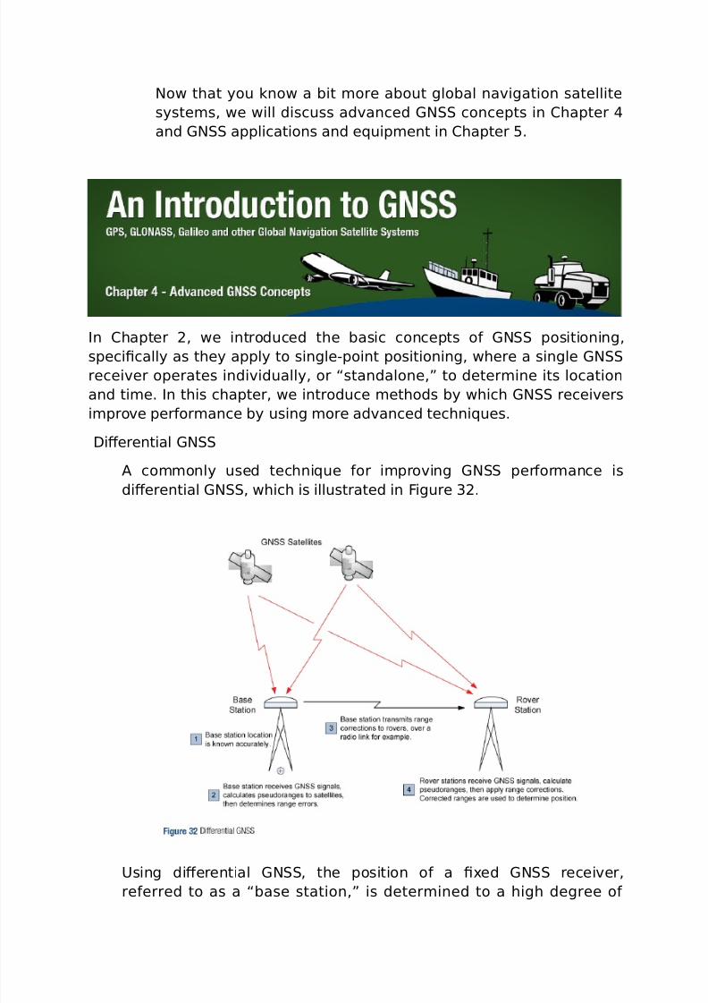
Now that you know a bit *ore about global na%igation satellite
syste*s, we will discuss ad%anced (N concepts in #hapter
and (N applications and e5uip*ent in #hapter B.
In #hapter 2, we introduced the basic concepts o& (N positioning,
speci0cally as they apply to singleCpoint positioning, where a single (N
recei%er operates indi%idually, or “standalone,! to deter*ine its location
and ti*e. In this chapter, we introduce *ethods by which (N recei%ers
i*pro%e per&or*ance by using *ore ad%anced techni5ues.
=iFerential (N
" co**only used techni5ue &or i*pro%ing (N per&or*ance is
diFerential (N, which is illustrated in igure 32.
9sing diFerential (N, the position o& a 0-ed (N recei%er,re&erred to as a “base station,! is deter*ined to a high degree o&
7/26/2019 teori gnss
http://slidepdf.com/reader/full/teori-gnss 45/73
accuracy using con%entional sur%eying techni5ues. he base station
deter*ines ranges to (N satellites in %iew using two *ethods:
9sing the codeCbased positioning techni5ue described in #hapter 2.
9sing the 8precisely) known locations o& the base station and thesatellites, the location o& satellites being deter*ined &ro* the
precisely known orbit ephe*erides and satellite ti*e.
he base station co*pares the ranges. =iFerences between the
ranges can be attributed to satellite ephe*eris and clock errors, but
*ostly to errors associated with at*ospheric delay. $ase stations
send these errors to other recei%ers 8ro%ers), which incorporate the
corrections into their position calculations.
=iFerential positioning re5uires a data link between base stations and
ro%ers i& corrections need to be applied in realCti*e, and at least &our
(N satellites in %iew at both the base station and the ro%ers. he
absolute accuracy o& the ro%er’s co*puted position will depend on
the absolute accuracy o& the base station’s position.
ince (N satellites orbit high abo%e the earth, the propagation
paths &ro* the satellites to the base stations and ro%ers pass through
si*ilar at*ospheric conditions, as long as the base station and ro%ers
are not too &ar apart. =iFerential (N works %ery well with baseC
stationCtoCro%er separations o& up to tens o& kilo*etres.
7/26/2019 teori gnss
http://slidepdf.com/reader/full/teori-gnss 46/73
atelliteCbased "ug*entation yste*s
or applications where the cost o& a diFerential (N syste* is
not Eusti0ed, or i& the ro%er stations are spread o%er too large an
area, a atelliteC$ased "ug*entation yste* 8$") *ay be
*ore appropriate &or enhancing position accuracy.
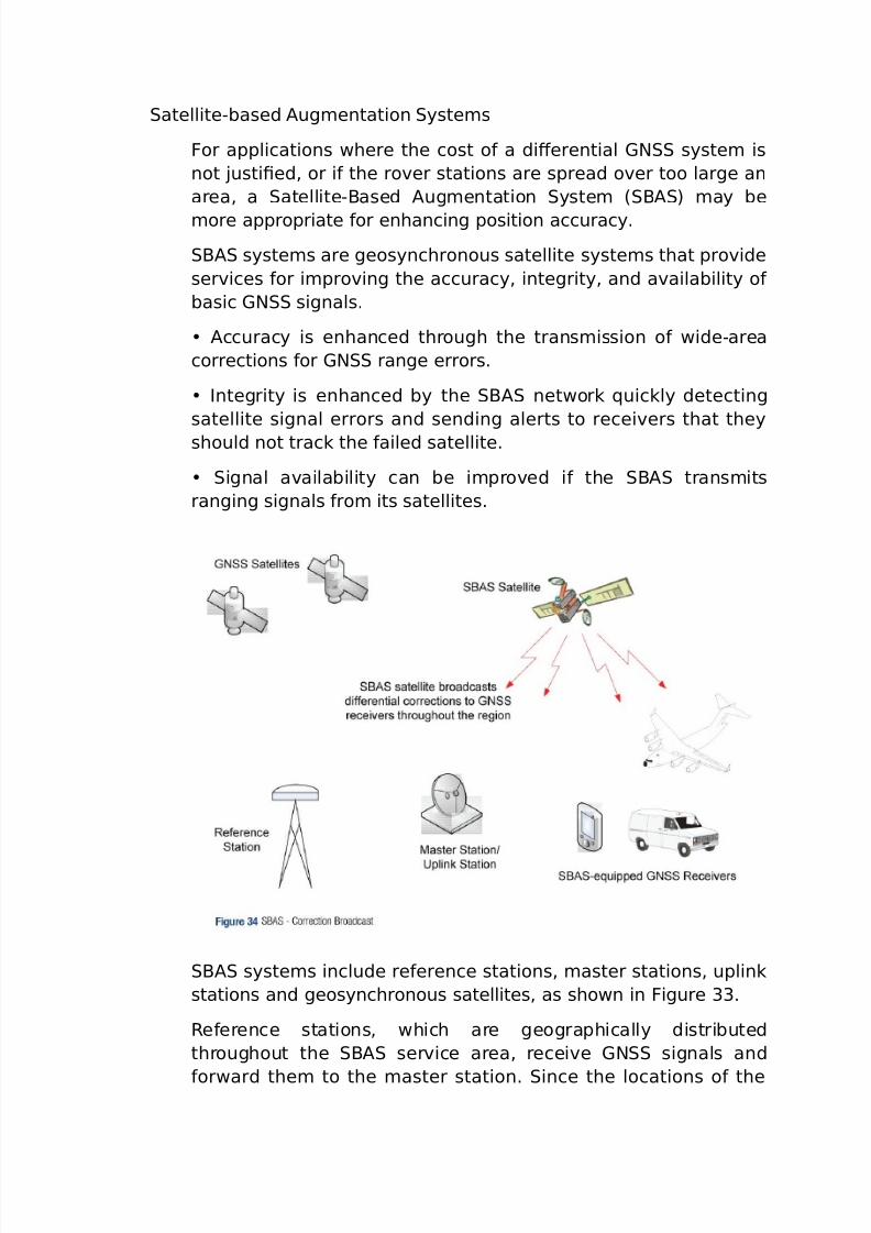
$" syste*s are geosynchronous satellite syste*s that pro%ide
ser%ices &or i*pro%ing the accuracy, integrity, and a%ailability o&
basic (N signals.
"ccuracy is enhanced through the trans*ission o& wideCarea
corrections &or (N range errors.
Integrity is enhanced by the $" network 5uickly detecting
satellite signal errors and sending alerts to recei%ers that they
should not track the &ailed satellite.
ignal a%ailability can be i*pro%ed i& the $" trans*its
ranging signals &ro* its satellites.
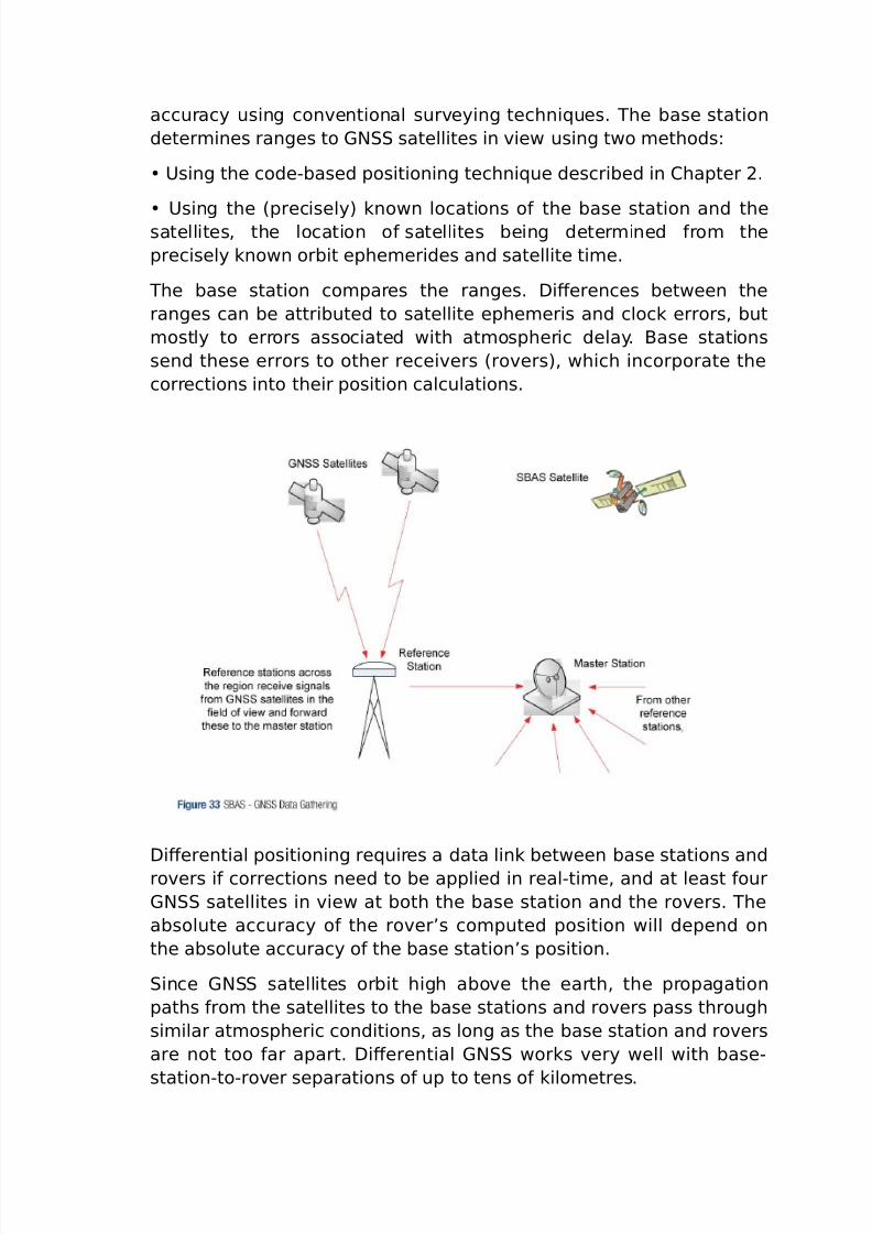
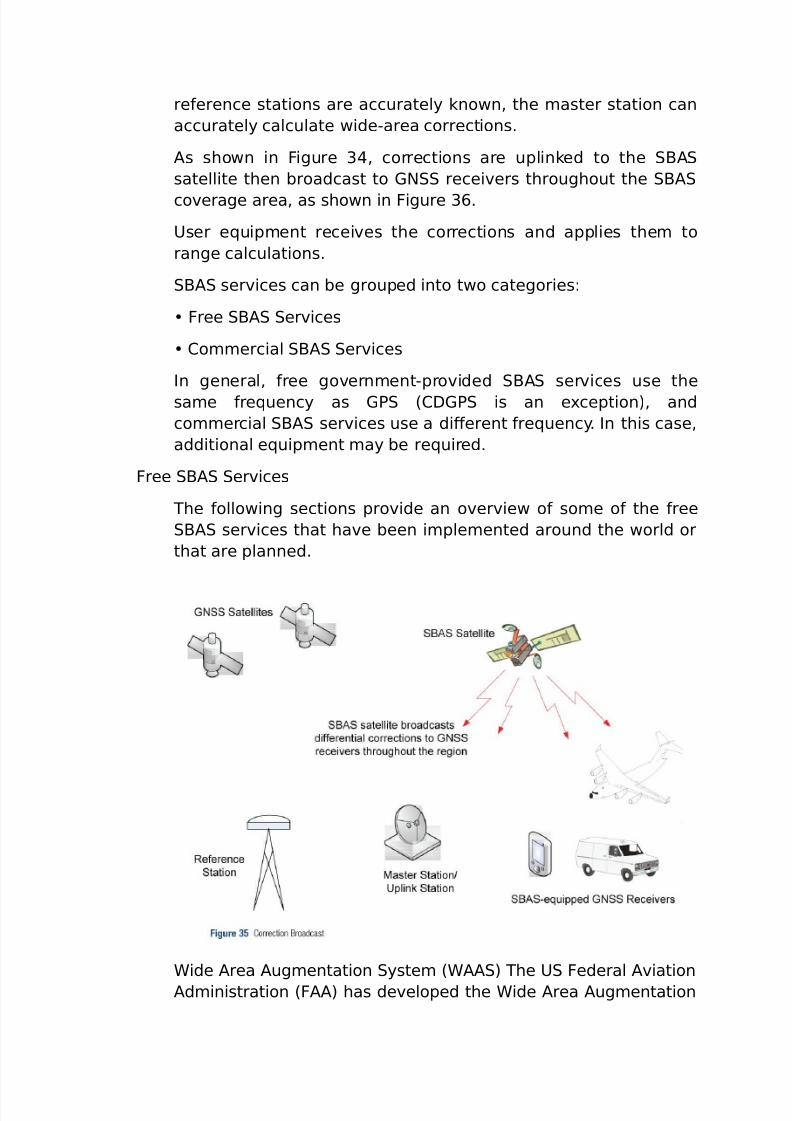
$" syste*s include re&erence stations, *aster stations, uplink
stations and geosynchronous satellites, as shown in igure 33.
@e&erence stations, which are geographically distributed
throughout the $" ser%ice area, recei%e (N signals and
&orward the* to the *aster station. ince the locations o& the
7/26/2019 teori gnss
http://slidepdf.com/reader/full/teori-gnss 47/73
re&erence stations are accurately known, the *aster station can
accurately calculate wideCarea corrections.
"s shown in igure 3, corrections are uplinked to the $"
satellite then broadcast to (N recei%ers throughout the $"
co%erage area, as shown in igure 3A.
9ser e5uip*ent recei%es the corrections and applies the* to
range calculations.
$" ser%ices can be grouped into two categories:
ree $" er%ices
#o**ercial $" er%ices
In general, &ree go%ern*entCpro%ided $" ser%ices use the
sa*e &re5uency as (7 8#=(7 is an e-ception), and
co**ercial $" ser%ices use a diFerent &re5uency. In this case,
additional e5uip*ent *ay be re5uired.
ree $" er%ices
he &ollowing sections pro%ide an o%er%iew o& so*e o& the &ree
$" ser%ices that ha%e been i*ple*ented around the world or
that are planned.
4ide "rea "ug*entation yste* 84"") he 9 ederal "%iation
"d*inistration 8"") has de%eloped the 4ide "rea "ug*entation

7/26/2019 teori gnss
http://slidepdf.com/reader/full/teori-gnss 48/73
yste* 84"") to pro%ide (7 corrections and a certi0ed le%el
o& integrity to the a%iation industry, to enable aircra&t to conduct
%arying le%els o& precision approach to airports. he corrections
are also a%ailable &ree o& charge to ci%ilian users in North
"*erica." 4ide "rea 'aster tation 84') recei%es (7 data &ro* 4ide
"rea @e&erence tations 84@) located throughout the 9nited
tates. he 4' calculates diFerential corrections then uplinks
these to two 4"" geostationary satellites &or broadcast across
the 9nited tates, as shown in igure 3A.
eparate corrections are calculated &or ionospheric delay,
satellite ti*ing, and satellite orbits, which allows error
corrections to be processed separately, i& appropriate, by the
user application.
4"" broadcasts correction data on the sa*e &re5uency as (7,
which allows &or the use o& the sa*e recei%er and antenna
e5uip*ent as that used &or (7. o recei%e correction data, user
e5uip*ent *ust ha%e line o& sight to one o& the 4"" satellites.
uropean (eostationary Na%igation ?%erlay er%ice 8(N?)
he uropean pace "gency, in cooperation with the uropean
#o**ission 8#) and 9@?C #?N@?> 8uropean ?rganiHation&or the a&ety o& "ir Na%igation) has de%eloped the uropean
(eostationary Na%igation ?%erlay er%ice 8(N?), a regional
aug*entation syste* that i*pro%es the accuracy o& positions
deri%ed &ro* (7 signals and alerts users about the reliability o&
the (7 signals.
7/26/2019 teori gnss
http://slidepdf.com/reader/full/teori-gnss 49/73
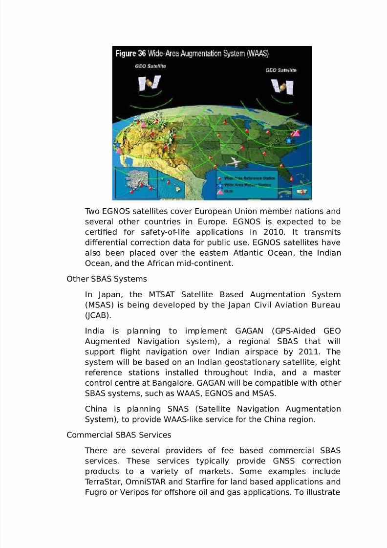
wo (N? satellites co%er uropean 9nion *e*ber nations and
se%eral other countries in urope. (N? is e-pected to be
certi0ed &or sa&etyCo&Cli&e applications in 2<1<. It trans*its
diFerential correction data &or public use. (N? satellites ha%e
also been placed o%er the eastern "tlantic ?cean, the Indian
?cean, and the "&rican *idCcontinent.
?ther $" yste*s
In Papan, the '" atellite $ased "ug*entation yste*
8'") is being de%eloped by the Papan #i%il "%iation $ureau
8P#"$).
India is planning to i*ple*ent ("("N 8(7C"ided (?
"ug*ented Na%igation syste*), a regional $" that will
support ight na%igation o%er Indian airspace by 2<11. he
syste* will be based on an Indian geostationary satellite, eight
re&erence stations installed throughout India, and a *aster
control centre at $angalore. ("("N will be co*patible with other$" syste*s, such as 4"", (N? and '".
#hina is planning N" 8atellite Na%igation "ug*entation
yste*), to pro%ide 4""Clike ser%ice &or the #hina region.
#o**ercial $" er%ices
here are se%eral pro%iders o& &ee based co**ercial $"
ser%ices. hese ser%ices typically pro%ide (N correction
products to a %ariety o& *arkets. o*e e-a*ples include
erratar, ?*ni"@ and tar0re &or land based applications andugro or eripos &or oFshore oil and gas applications. o illustrate
7/26/2019 teori gnss
http://slidepdf.com/reader/full/teori-gnss 50/73
co**ercial $" ser%ices, the &ollowing section pro%ides *ore
detail on the erratar ser%ice.
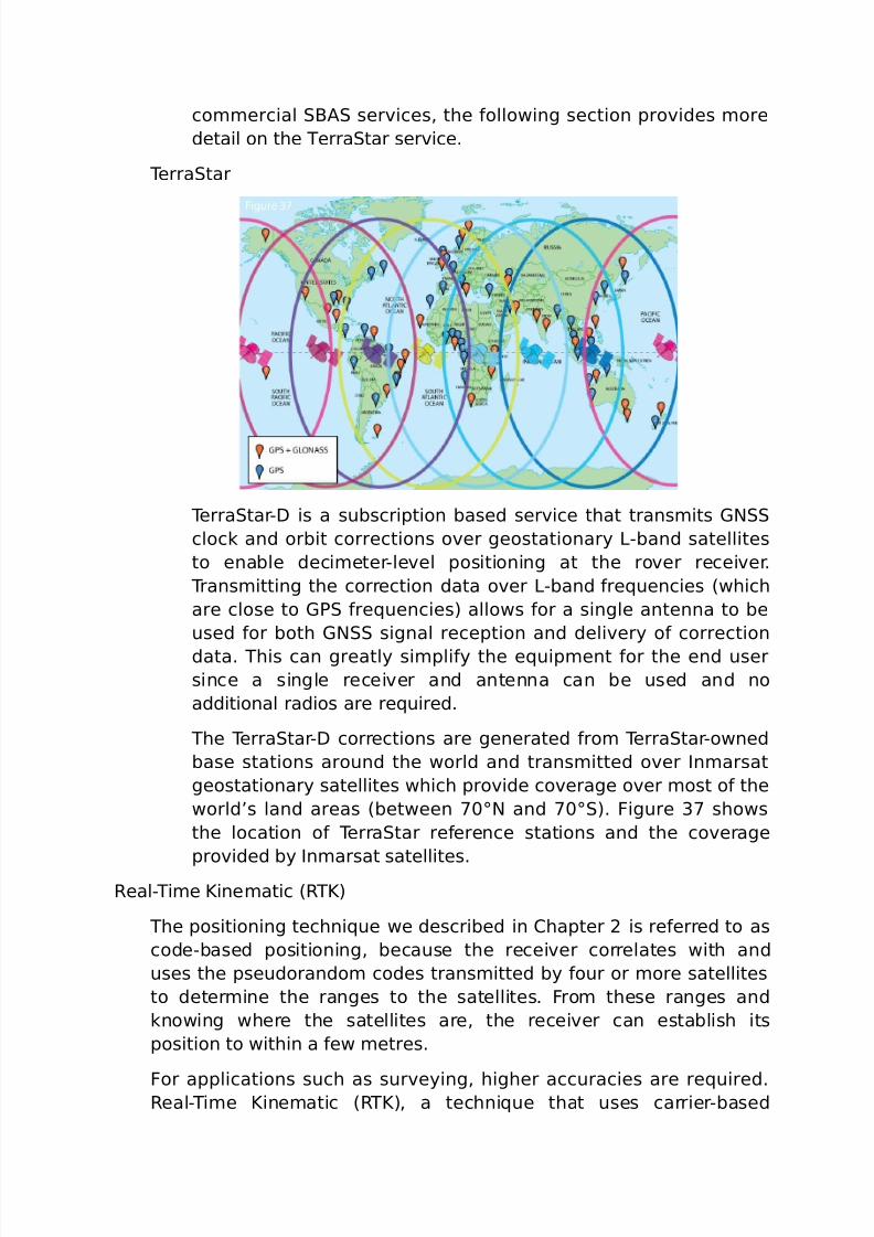
erratar
erratarC= is a subscription based ser%ice that trans*its (N
clock and orbit corrections o%er geostationary >Cband satellites
to enable deci*eterCle%el positioning at the ro%er recei%er.
rans*itting the correction data o%er >Cband &re5uencies 8which
are close to (7 &re5uencies) allows &or a single antenna to be
used &or both (N signal reception and deli%ery o& correction
data. his can greatly si*pli&y the e5uip*ent &or the end user
since a single recei%er and antenna can be used and no
additional radios are re5uired.
he erratarC= corrections are generated &ro* erratarCowned
base stations around the world and trans*itted o%er In*arsat
geostationary satellites which pro%ide co%erage o%er *ost o& the
world’s land areas 8between ;<XN and ;<X). igure 3; shows
the location o& erratar re&erence stations and the co%erage
pro%ided by In*arsat satellites.
@ealCi*e Rine*atic 8@R)
he positioning techni5ue we described in #hapter 2 is re&erred to as
codeCbased positioning, because the recei%er correlates with and
uses the pseudorando* codes trans*itted by &our or *ore satellites
to deter*ine the ranges to the satellites. ro* these ranges and
knowing where the satellites are, the recei%er can establish its
position to within a &ew *etres.
or applications such as sur%eying, higher accuracies are re5uired.@ealCi*e Rine*atic 8@R), a techni5ue that uses carrierCbased
7/26/2019 teori gnss
http://slidepdf.com/reader/full/teori-gnss 51/73
ranging, pro%ides ranges 8and there&ore positions) that are orders o&
*agnitude *ore precise than those a%ailable through codeCbased
positioning.
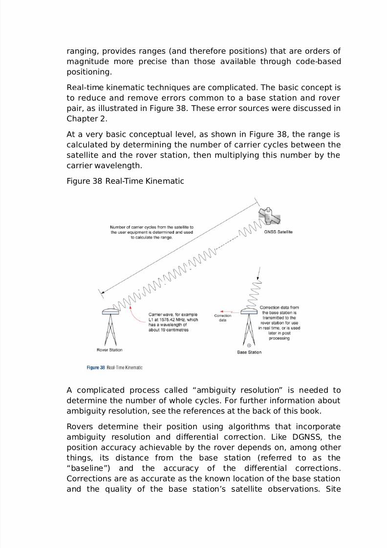
@ealCti*e kine*atic techni5ues are co*plicated. he basic concept is
to reduce and re*o%e errors co**on to a base station and ro%erpair, as illustrated in igure 3J. hese error sources were discussed in
#hapter 2.
"t a %ery basic conceptual le%el, as shown in igure 3J, the range is
calculated by deter*ining the nu*ber o& carrier cycles between the
satellite and the ro%er station, then *ultiplying this nu*ber by the
carrier wa%elength.
igure 3J @ealCi*e Rine*atic
" co*plicated process called “a*biguity resolution! is needed to
deter*ine the nu*ber o& whole cycles. or &urther in&or*ation about
a*biguity resolution, see the re&erences at the back o& this book.
@o%ers deter*ine their position using algorith*s that incorporate
a*biguity resolution and diFerential correction. >ike =(N, the
position accuracy achie%able by the ro%er depends on, a*ong other
things, its distance &ro* the base station 8re&erred to as the
“baseline!) and the accuracy o& the diFerential corrections.
#orrections are as accurate as the known location o& the base stationand the 5uality o& the base station’s satellite obser%ations. ite
7/26/2019 teori gnss
http://slidepdf.com/reader/full/teori-gnss 52/73
selection is i*portant &or *ini*iHing en%iron*ental eFects such as
inter&erence and *ultipath, as is the 5uality o& the base station and
ro%er recei%ers and antennas.
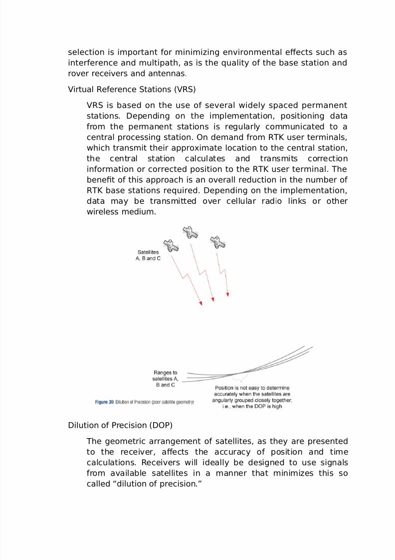
irtual @e&erence tations 8@)
@ is based on the use o& se%eral widely spaced per*anent
stations. =epending on the i*ple*entation, positioning data
&ro* the per*anent stations is regularly co**unicated to a
central processing station. ?n de*and &ro* @R user ter*inals,
which trans*it their appro-i*ate location to the central station,
the central station calculates and trans*its correction
in&or*ation or corrected position to the @R user ter*inal. he
bene0t o& this approach is an o%erall reduction in the nu*ber o&
@R base stations re5uired. =epending on the i*ple*entation,
data *ay be trans*itted o%er cellular radio links or other
wireless *ediu*.
=ilution o& 7recision 8=?7)
he geo*etric arrange*ent o& satellites, as they are presented
to the recei%er, aFects the accuracy o& position and ti*e
calculations. @ecei%ers will ideally be designed to use signals
&ro* a%ailable satellites in a *anner that *ini*iHes this so
called “dilution o& precision.!
7/26/2019 teori gnss
http://slidepdf.com/reader/full/teori-gnss 53/73
he calculated ranges still include errors &ro* such sources as
satellite clock and ephe*erides, and ionC ospheric and
tropospheric delays. o eli*inate these errors and to take
ad%antage o& the precision o& carrierCbased *easure*ents, @R
per&or*ance re5uires *easure*ents to be trans*itted &ro* thebase station to the ro%er station.
o illustrate =?7, consider the e-a*ple shown in igure 3,
where the satellites being tracked are clustered in a s*all region
o& the sky.
In the e-a*ple shown in igure 3, intentionally a bit e-tre*e to
illustrate the eFect o& =?7, it is di+cult to deter*ine where the
ranges intersect. 7osition is “spread! o%er the area o& range
intersections, an area which is enlarged by range inaccuracies
8which can be %iewed as a “thickening! o& the range lines).
"s shown in igure < below, the addition o& a range
*easure*ent to a satellite that is angularly separated &ro* the
cluster allows us to deter*ine a 0- *ore precisely.
=?7 is a nu*erical representation o& satellite geo*etry, and it
is dependent on the locations o& satellites that are %isible to the
recei%er.
he s*aller the %alue o& =?7, the *ore precise the result o& the ti*e or position calculation. he relationship is shown in the
&ollowing &or*ula:
Inaccuracy o& 7osition 'easure*ent Q =?7 - Inaccuracy o&
@ange 'easure*ent
o, i& =?7 is %ery high, the inaccuracy o& the position
*easure*ent will be *uch larger than the inaccuracy o& the
range *easure*ent.
=?7 can be used as the basis &or selecting the satellites onwhich the position solution will be basedG speci0cally, selecting
satellites to *ini*iHe =?7 &or a particuar application.
" =?7 abo%e A results in generally unacceptable accuracies &or
=(7 and @R operations
=?7 %aries with ti*e o& day and geographic location but, &or a
0-ed position, the geo*etric presentation o& the satellites
repeats e%ery day, &or (7.
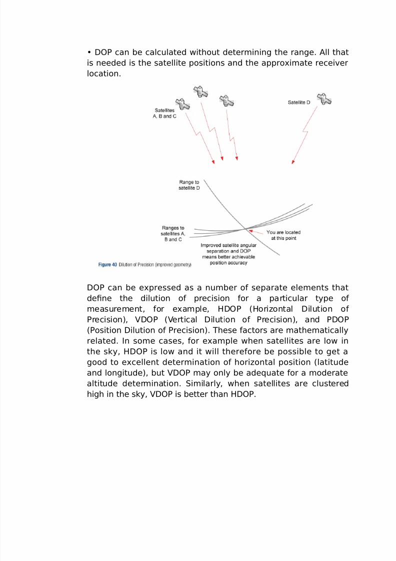
7/26/2019 teori gnss
http://slidepdf.com/reader/full/teori-gnss 54/73
=?7 can be calculated without deter*ining the range. "ll that
is needed is the satellite positions and the appro-i*ate recei%er
location.
=?7 can be e-pressed as a nu*ber o& separate ele*ents that
de0ne the dilution o& precision &or a particular type o&
*easure*ent, &or e-a*ple, /=?7 8/oriHontal =ilution o&
7recision), =?7 8ertical =ilution o& 7recision), and 7=?7
87osition =ilution o& 7recision). hese &actors are *athe*atically
related. In so*e cases, &or e-a*ple when satellites are low in
the sky, /=?7 is low and it will there&ore be possible to get a
good to e-cellent deter*ination o& horiHontal position 8latitude
and longitude), but =?7 *ay only be ade5uate &or a *oderate
altitude deter*ination. i*ilarly, when satellites are clustered
high in the sky, =?7 is better than /=?7.
7/26/2019 teori gnss
http://slidepdf.com/reader/full/teori-gnss 55/73
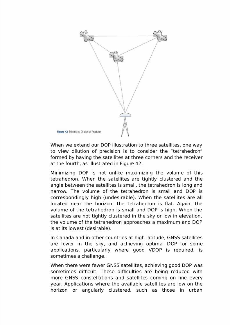
4hen we e-tend our =?7 illustration to three satellites, one way
to %iew dilution o& precision is to consider the “tetrahedron!
&or*ed by ha%ing the satellites at three corners and the recei%er
at the &ourth, as illustrated in igure 2.
'ini*iHing =?7 is not unlike *a-i*iHing the %olu*e o& this
tetrahedron. 4hen the satellites are tightly clustered and the
angle between the satellites is s*all, the tetrahedron is long and
narrow. he %olu*e o& the tetrahedron is s*all and =?7 is
correspondingly high 8undesirable). 4hen the satellites are all
located near the horiHon, the tetrahedron is at. "gain, the
%olu*e o& the tetrahedron is s*all and =?7 is high. 4hen the
satellites are not tightly clustered in the sky or low in ele%ation,
the %olu*e o& the tetrahedron approaches a *a-i*u* and =?7
is at its lowest 8desirable).
In #anada and in other countries at high latitude, (N satellites
are lower in the sky, and achie%ing opti*al =?7 &or so*e
applications, particularly where good =?7 is re5uired, is
so*eti*es a challenge.
4hen there were &ewer (N satellites, achie%ing good =?7 was
so*eti*es di+cult. hese di+culties are being reduced with
*ore (N constellations and satellites co*ing on line e%ery
year. "pplications where the a%ailable satellites are low on thehoriHon or angularly clustered, such as those in urban
7/26/2019 teori gnss
http://slidepdf.com/reader/full/teori-gnss 56/73
en%iron*ents or in deep openCpit *ining, *ay still e-pose users
to the pit&alls o& =?7. I& you know your application will ha%e
obstructed conditions, you *ay want to use a *ission planning
tool to deter*ine the ideal ti*e 6 the ti*e with the ideal =?7 6
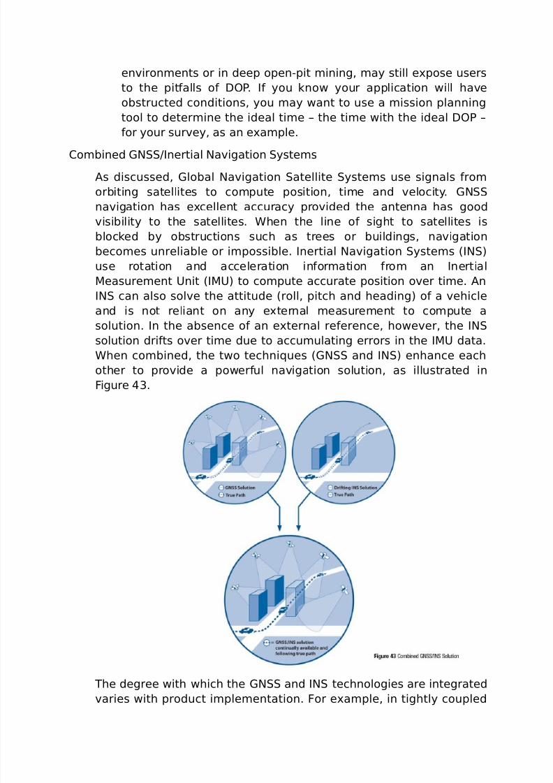
&or your sur%ey, as an e-a*ple.#o*bined (NOInertial Na%igation yste*s
"s discussed, (lobal Na%igation atellite yste*s use signals &ro*
orbiting satellites to co*pute position, ti*e and %elocity. (N
na%igation has e-cellent accuracy pro%ided the antenna has good
%isibility to the satellites. 4hen the line o& sight to satellites is
blocked by obstructions such as trees or buildings, na%igation
beco*es unreliable or i*possible. Inertial Na%igation yste*s 8IN)
use rotation and acceleration in&or*ation &ro* an Inertial
'easure*ent 9nit 8I'9) to co*pute accurate position o%er ti*e. "n
IN can also sol%e the attitude 8roll, pitch and heading) o& a %ehicle
and is not reliant on any e-ternal *easure*ent to co*pute a
solution. In the absence o& an e-ternal re&erence, howe%er, the IN
solution dri&ts o%er ti*e due to accu*ulating errors in the I'9 data.
4hen co*bined, the two techni5ues 8(N and IN) enhance each
other to pro%ide a power&ul na%igation solution, as illustrated in
igure 3.
he degree with which the (N and IN technologies are integrated%aries with product i*ple*entation. or e-a*ple, in tightly coupled
7/26/2019 teori gnss
http://slidepdf.com/reader/full/teori-gnss 57/73
solutions, (N obser%ations are used directly by the inertial solution
to take ad%antage o& a%ailable (N data, e%en when only a &ew
satellites are %isible 8&or instance, to reset or adEust the position being
output by the IN). ightly coupled solutions allow &eedback o& the
inertial solution into the (N recei%er to i*pro%e (Nper&or*ance, &or e-a*ple, signal reac5uisition and con%ergence ti*e.
o su**ariHe, co*bining (N and IN technologies signi0cantly
increases opportunities &or application de%elop*ent by o%erco*ing
the li*itations o& the indi%idual technologies.
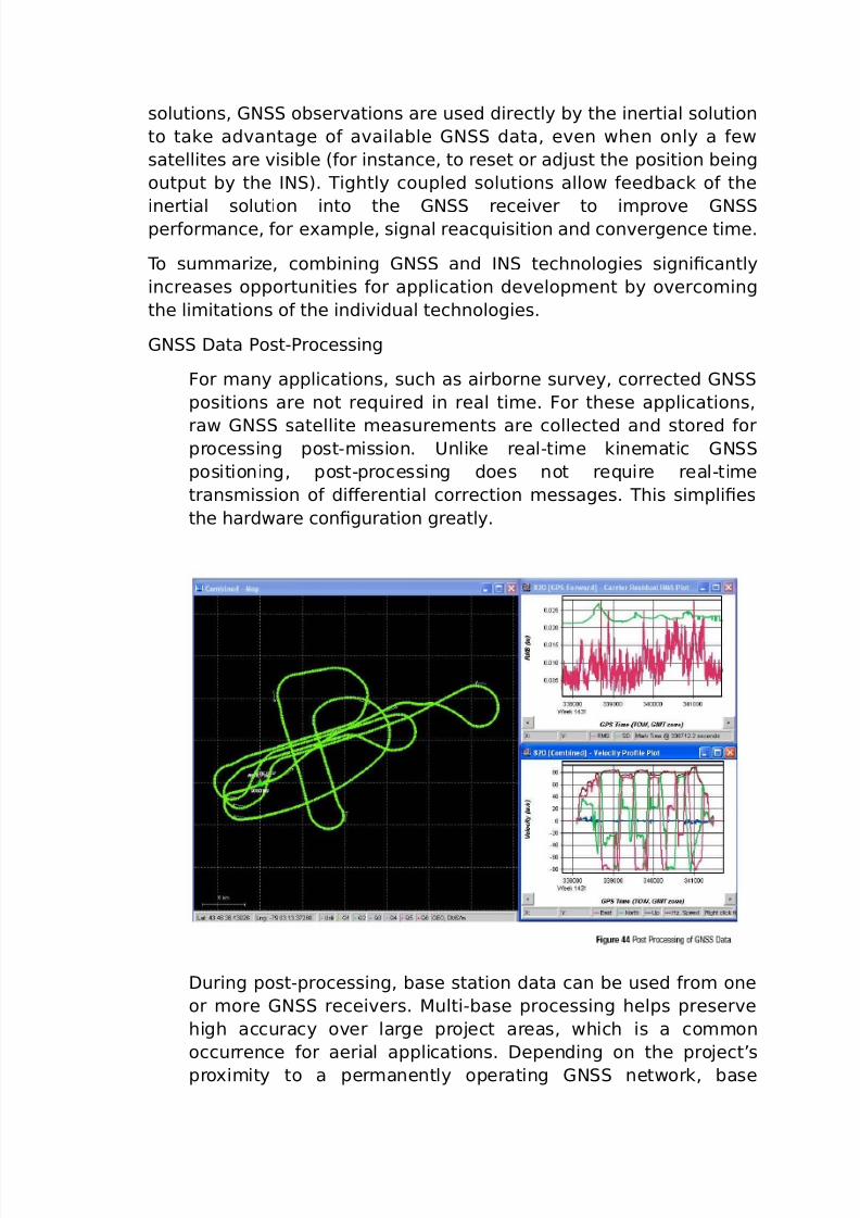
(N =ata 7ostC7rocessing
or *any applications, such as airborne sur%ey, corrected (N
positions are not re5uired in real ti*e. or these applications,
raw (N satellite *easure*ents are collected and stored &orprocessing postC*ission. 9nlike realCti*e kine*atic (N
positioning, postCprocessing does not re5uire realCti*e
trans*ission o& diFerential correction *essages. his si*pli0es
the hardware con0guration greatly.
=uring postCprocessing, base station data can be used &ro* one
or *ore (N recei%ers. 'ultiCbase processing helps preser%e
high accuracy o%er large proEect areas, which is a co**on
occurrence &or aerial applications. =epending on the proEect’s
pro-i*ity to a per*anently operating (N network, base
7/26/2019 teori gnss
http://slidepdf.com/reader/full/teori-gnss 58/73
station data can o&ten be &reely downloaded, eli*inating the
need &or establishing your own base station8s). 'oreo%er, it is
possible to process without any base station data through
7recise 7oint 7ositioning 8777), which utiliHes downloaded precise
clock and ephe*eris data.7ostCprocessing applications oFer a great deal o& e-ibility.
"pplications can in%ol%e stationary or *o%ing base stations, and
so*e support integration with custo*er or thirdCparty so&tware
*odules. 7ost processing applications *ay be designed to run
on personal co*puters, accessible through si*pleCtoCuse
graphical user inter&aces, as illustrated in igure .
In the e-a*ple shown in igure 3, the route taken by the
%ehicle is shown in the le&t side o& the screen, and
*easure*ents recorded during the *ission, such as %elocity,
resol%ed into horiHontal and %ertical co*ponents, are shown in
the right side.
7ost processing generally results in a *ore accurate,
co*prehensi%e solution than is possible in real ti*e.
#losing @e*arks
his chapter has described, at a high le%el, so*e %ery co*ple-
(N concepts. I& you want to learn *ore about these, we ha%epro%ided a list o& re&erences at the end o& the book.
7/26/2019 teori gnss
http://slidepdf.com/reader/full/teori-gnss 59/73
“%ery generation needs a new re%olution.! ho*as PeFerson, inuential
ounding ather and third president o& the 9nited tates.
4e don’t think it is an o%erstate*ent to say that the application o& (N
is re%olutioniHing, and will continue to re%olutioniHe, the way businesses
and go%ern*ents operate, and how we conduct our personal li%es. hischapter highlights so*e o& the incredible (N applications and
e5uip*ent that are now a%ailable.
"pplications
In a short book, it is i*possible to describe all (N applications.
4hile we will highlight so*e consu*er applications o& this
technology, our &ocus will be on co**ercial applications in %arious
industries, including:
ransportation 'achine #ontrol ur%eying 7ort "uto*ation
#onsu*er
i*ing 'arine =e&ence
(N technology has been adopted by the consu*er *arket, in
a broad range o& products.
(N recei%ers are now routinely integrated into *obile
co**unications e5uip*ent, to support applications that display
*aps showing the location o& and best route to stores andrestaurants.
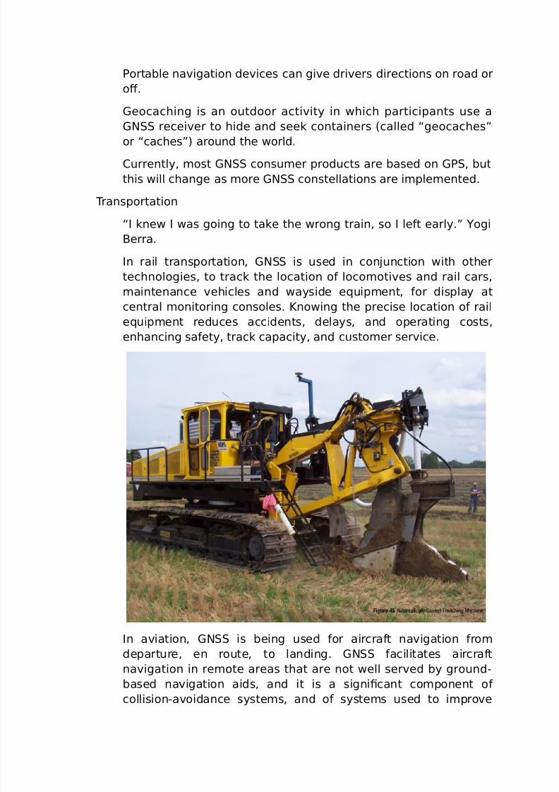
7/26/2019 teori gnss
http://slidepdf.com/reader/full/teori-gnss 60/73
7ortable na%igation de%ices can gi%e dri%ers directions on road or
oF.
(eocaching is an outdoor acti%ity in which participants use a
(N recei%er to hide and seek containers 8called “geocaches!
or “caches!) around the world.
#urrently, *ost (N consu*er products are based on (7, but
this will change as *ore (N constellations are i*ple*ented.
ransportation
“I knew I was going to take the wrong train, so I le&t early.! Dogi
$erra.
In rail transportation, (N is used in conEunction with other
technologies, to track the location o& loco*oti%es and rail cars,*aintenance %ehicles and wayside e5uip*ent, &or display at
central *onitoring consoles. Rnowing the precise location o& rail
e5uip*ent reduces accidents, delays, and operating costs,
enhancing sa&ety, track capacity, and custo*er ser%ice.
In a%iation, (N is being used &or aircra&t na%igation &ro*
departure, en route, to landing. (N &acilitates aircra&t
na%igation in re*ote areas that are not well ser%ed by groundC
based na%igation aids, and it is a signi0cant co*ponent o&
collisionCa%oidance syste*s, and o& syste*s used to i*pro%e
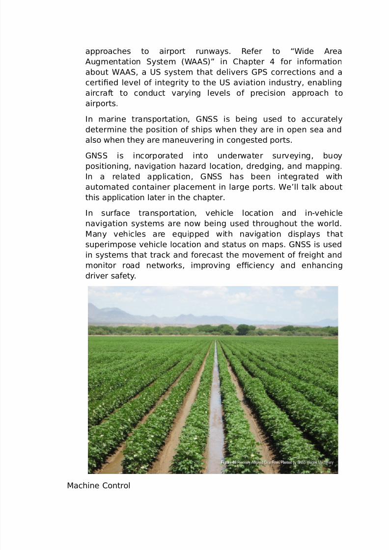
7/26/2019 teori gnss
http://slidepdf.com/reader/full/teori-gnss 61/73
approaches to airport runways. @e&er to “4ide "rea
"ug*entation yste* 84"")! in #hapter &or in&or*ation
about 4"", a 9 syste* that deli%ers (7 corrections and a
certi0ed le%el o& integrity to the 9 a%iation industry, enabling
aircra&t to conduct %arying le%els o& precision approach toairports.
In *arine transportation, (N is being used to accurately
deter*ine the position o& ships when they are in open sea and
also when they are *aneu%ering in congested ports.
(N is incorporated into underwater sur%eying, buoy
positioning, na%igation haHard location, dredging, and *apping.
In a related application, (N has been integrated with
auto*ated container place*ent in large ports. 4e’ll talk about
this application later in the chapter.
In sur&ace transportation, %ehicle location and inC%ehicle
na%igation syste*s are now being used throughout the world.
'any %ehicles are e5uipped with na%igation displays that
superi*pose %ehicle location and status on *aps. (N is used
in syste*s that track and &orecast the *o%e*ent o& &reight and
*onitor road networks, i*pro%ing e+ciency and enhancing
dri%er sa&ety.
'achine #ontrol

7/26/2019 teori gnss
http://slidepdf.com/reader/full/teori-gnss 62/73
(N technology is being integrated into e5uip*ent such as
bulldoHers, e-ca%ators, graders, pa%ers and &ar* *achinery to
enhance producti%ity in the realCti*e operation o& this
e5uip*ent, and to pro%ide situational awareness in&or*ation to
the e5uip*ent operator. he adoption o& (NCbased *achinecontrol is si*ilar in its i*pact to the earlier adoption o&
hydraulics technology in *achinery, which has had a pro&ound
eFect on producti%ity and reliability.
he three *ain areas o& *achine control are agriculture,
construction and sur&ace *ining. o*e o& the bene0ts o& (NC
based *achine control are su**ariHed below:
+ciency: $y helping the e5uip*ent operator get to the
desired grade *ore 5uickly, (N helps speed up the work,
reducing capital and operating costs.
"ccuracy: he precision achie%able by (NCbased solutions
*ini*iHes the need to stop work while a sur%ey crew *easures
the grade.
Pob 'anage*ent: 'anagers and contractors ha%e access to
accurate in&or*ation about the Eobsite, and the in&or*ation can
be %iewed re*otely.
=ata 'anage*ent: 9sers can print out status reports, sa%ei*portant data and trans&er 0les to head o+ce.
he&t =etection: (N allows users to de0ne a “%irtual &ence!
about their e5uip*ent and property, &or the purpose o&
auto*atically raising an alar* when e5uip*ent is re*o%ed, then
pro%iding e5uip*ent tracking in&or*ation to the authorities.
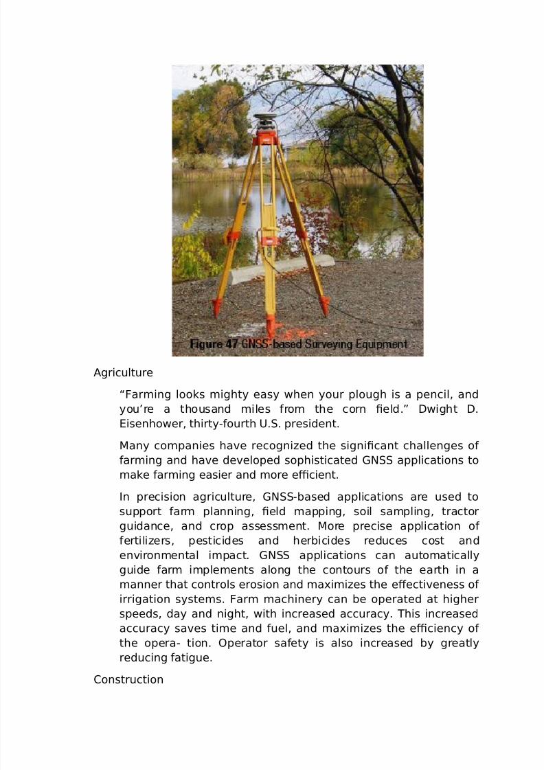
7/26/2019 teori gnss
http://slidepdf.com/reader/full/teori-gnss 63/73
"griculture
“ar*ing looks *ighty easy when your plough is a pencil, and
you’re a thousand *iles &ro* the corn 0eld.! =wight =.
isenhower, thirtyC&ourth 9.. president.
'any co*panies ha%e recogniHed the signi0cant challenges o&
&ar*ing and ha%e de%eloped sophisticated (N applications to
*ake &ar*ing easier and *ore e+cient.
In precision agriculture, (NCbased applications are used to
support &ar* planning, 0eld *apping, soil sa*pling, tractor
guidance, and crop assess*ent. 'ore precise application o&
&ertiliHers, pesticides and herbicides reduces cost anden%iron*ental i*pact. (N applications can auto*atically
guide &ar* i*ple*ents along the contours o& the earth in a
*anner that controls erosion and *a-i*iHes the eFecti%eness o&
irrigation syste*s. ar* *achinery can be operated at higher
speeds, day and night, with increased accuracy. his increased
accuracy sa%es ti*e and &uel, and *a-i*iHes the e+ciency o&
the operaC tion. ?perator sa&ety is also increased by greatly
reducing &atigue.
#onstruction
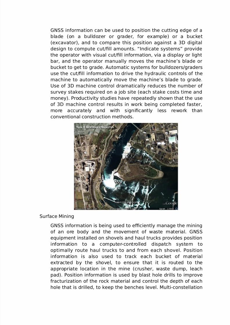
7/26/2019 teori gnss
http://slidepdf.com/reader/full/teori-gnss 64/73
(N in&or*ation can be used to position the cutting edge o& a
blade 8on a bulldoHer or grader, &or e-a*ple) or a bucket
8e-ca%ator), and to co*pare this position against a 3= digital
design to co*pute cutO0ll a*ounts. “Indicate syste*s! pro%ide
the operator with %isual cutO0ll in&or*ation, %ia a display or lightbar, and the operator *anually *o%es the *achine’s blade or
bucket to get to grade. "uto*atic syste*s &or bulldoHersOgraders
use the cutO0ll in&or*ation to dri%e the hydraulic controls o& the
*achine to auto*atically *o%e the *achine’s blade to grade.
9se o& 3= *achine control dra*atically reduces the nu*ber o&
sur%ey stakes re5uired on a Eob site 8each stake costs ti*e and
*oney). 7roducti%ity studies ha%e repeatedly shown that the use
o& 3= *achine control results in work being co*pleted &aster,
*ore accurately and with signi0cantly less rework than
con%entional construction *ethods.
ur&ace 'ining
(N in&or*ation is being used to e+ciently *anage the *iningo& an ore body and the *o%e*ent o& waste *aterial. (N
e5uip*ent installed on sho%els and haul trucks pro%ides position
in&or*ation to a co*puterCcontrolled dispatch syste* to
opti*ally route haul trucks to and &ro* each sho%el. 7osition
in&or*ation is also used to track each bucket o& *aterial
e-tracted by the sho%el, to ensure that it is routed to the
appropriate location in the *ine 8crusher, waste du*p, leach
pad). 7osition in&or*ation is used by blast hole drills to i*pro%e
&racturiHation o& the rock *aterial and control the depth o& each
hole that is drilled, to keep the benches le%el. 'ultiCconstellation
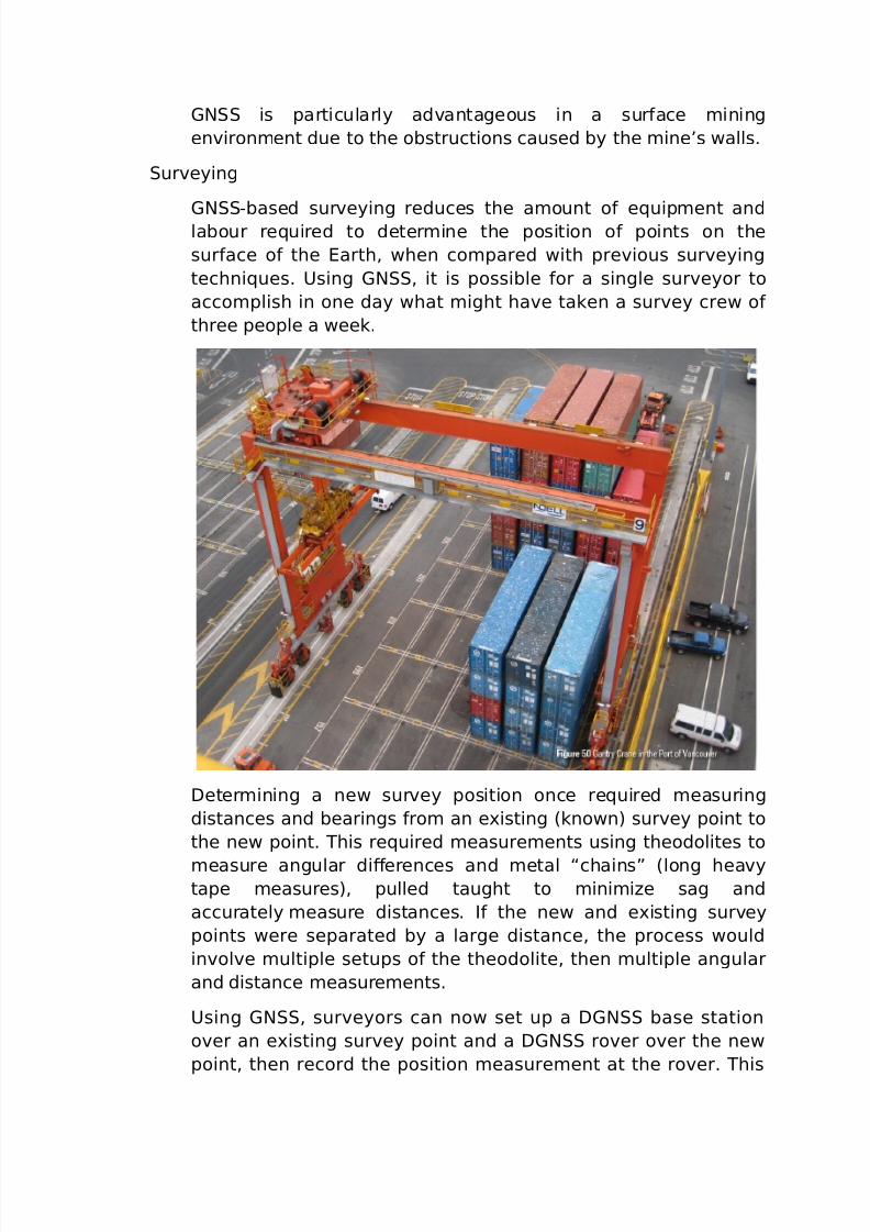
7/26/2019 teori gnss
http://slidepdf.com/reader/full/teori-gnss 65/73
(N is particularly ad%antageous in a sur&ace *ining
en%iron*ent due to the obstructions caused by the *ine’s walls.
ur%eying
(NCbased sur%eying reduces the a*ount o& e5uip*ent andlabour re5uired to deter*ine the position o& points on the
sur&ace o& the arth, when co*pared with pre%ious sur%eying
techni5ues. 9sing (N, it is possible &or a single sur%eyor to
acco*plish in one day what *ight ha%e taken a sur%ey crew o&
three people a week.
=eter*ining a new sur%ey position once re5uired *easuring
distances and bearings &ro* an e-isting 8known) sur%ey point to
the new point. his re5uired *easure*ents using theodolites to
*easure angular diFerences and *etal “chains! 8long hea%ytape *easures), pulled taught to *ini*iHe sag and
accurately *easure distances. I& the new and e-isting sur%ey
points were separated by a large distance, the process would
in%ol%e *ultiple setups o& the theodolite, then *ultiple angular
and distance *easure*ents.
9sing (N, sur%eyors can now set up a =(N base station
o%er an e-isting sur%ey point and a =(N ro%er o%er the new
point, then record the position *easure*ent at the ro%er. his
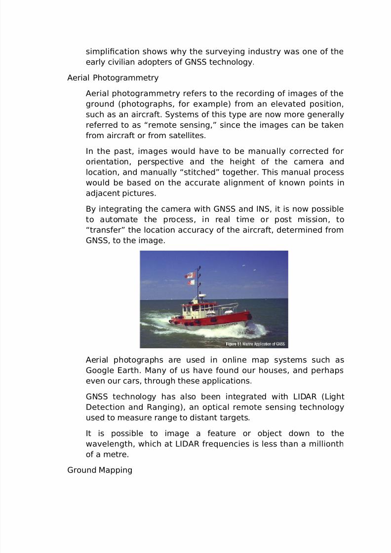
7/26/2019 teori gnss
http://slidepdf.com/reader/full/teori-gnss 66/73
si*pli0cation shows why the sur%eying industry was one o& the
early ci%ilian adopters o& (N technology.
"erial 7hotogra**etry
"erial photogra**etry re&ers to the recording o& i*ages o& theground 8photographs, &or e-a*ple) &ro* an ele%ated position,
such as an aircra&t. yste*s o& this type are now *ore generally
re&erred to as “re*ote sensing,! since the i*ages can be taken
&ro* aircra&t or &ro* satellites.
In the past, i*ages would ha%e to be *anually corrected &or
orientation, perspecti%e and the height o& the ca*era and
location, and *anually “stitched! together. his *anual process
would be based on the accurate align*ent o& known points in
adEacent pictures.
$y integrating the ca*era with (N and IN, it is now possible
to auto*ate the process, in real ti*e or post *ission, to
“trans&er! the location accuracy o& the aircra&t, deter*ined &ro*
(N, to the i*age.
"erial photographs are used in online *ap syste*s such as
(oogle arth. 'any o& us ha%e &ound our houses, and perhaps
e%en our cars, through these applications.
(N technology has also been integrated with >I="@ 8>ight
=etection and @anging), an optical re*ote sensing technology
used to *easure range to distant targets.
It is possible to i*age a &eature or obEect down to the
wa%elength, which at >I="@ &re5uencies is less than a *illionth
o& a *etre.
(round 'apping
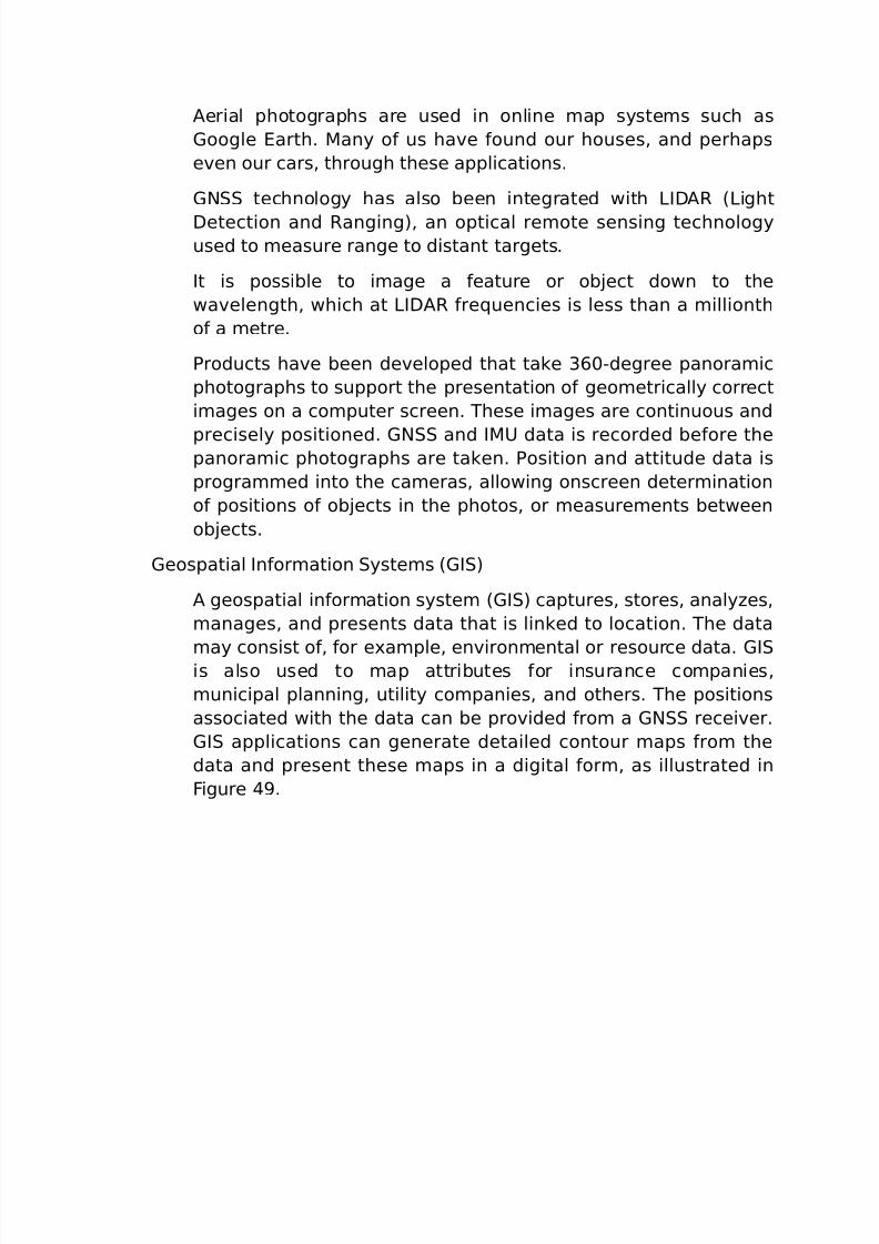
7/26/2019 teori gnss
http://slidepdf.com/reader/full/teori-gnss 67/73
"erial photographs are used in online *ap syste*s such as
(oogle arth. 'any o& us ha%e &ound our houses, and perhaps
e%en our cars, through these applications.
(N technology has also been integrated with >I="@ 8>ight
=etection and @anging), an optical re*ote sensing technologyused to *easure range to distant targets.
It is possible to i*age a &eature or obEect down to the
wa%elength, which at >I="@ &re5uencies is less than a *illionth
o& a *etre.
7roducts ha%e been de%eloped that take 3A<Cdegree panora*ic
photographs to support the presentation o& geo*etrically correct
i*ages on a co*puter screen. hese i*ages are continuous and
precisely positioned. (N and I'9 data is recorded be&ore thepanora*ic photographs are taken. 7osition and attitude data is
progra**ed into the ca*eras, allowing onscreen deter*ination
o& positions o& obEects in the photos, or *easure*ents between
obEects.
(eospatial In&or*ation yste*s 8(I)
" geospatial in&or*ation syste* 8(I) captures, stores, analyHes,
*anages, and presents data that is linked to location. he data
*ay consist o&, &or e-a*ple, en%iron*ental or resource data. (Iis also used to *ap attributes &or insurance co*panies,
*unicipal planning, utility co*panies, and others. he positions
associated with the data can be pro%ided &ro* a (N recei%er.
(I applications can generate detailed contour *aps &ro* the
data and present these *aps in a digital &or*, as illustrated in
igure .
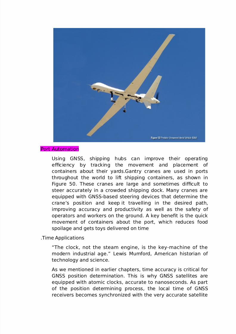
7/26/2019 teori gnss
http://slidepdf.com/reader/full/teori-gnss 68/73
7ort "uto*ation
9sing (N, shipping hubs can i*pro%e their operating
e+ciency by tracking the *o%e*ent and place*ent o&
containers about their yards.(antry cranes are used in ports
throughout the world to li&t shipping containers, as shown in
igure B<. hese cranes are large and so*eti*es di+cult to
steer accurately in a crowded shipping dock. 'any cranes are
e5uipped with (NCbased steering de%ices that deter*ine the
crane’s position and keep it tra%elling in the desired path,
i*pro%ing accuracy and producti%ity as well as the sa&ety o&
operators and workers on the ground. " key bene0t is the 5uick
*o%e*ent o& containers about the port, which reduces &ood
spoilage and gets toys deli%ered on ti*e
.i*e "pplications
“he clock, not the stea* engine, is the keyC*achine o& the
*odern industrial age.! >ewis 'u*&ord, "*erican historian o&
technology and science.
"s we *entioned in earlier chapters, ti*e accuracy is critical &or
(N position deter*ination. his is why (N satellites are
e5uipped with ato*ic clocks, accurate to nanoseconds. "s part
o& the position deter*ining process, the local ti*e o& (N
recei%ers beco*es synchroniHed with the %ery accurate satellite
7/26/2019 teori gnss
http://slidepdf.com/reader/full/teori-gnss 69/73
ti*e. his ti*e in&or*ation, by itsel&, has *any applications,
including the synchroniHation o& co**unication syste*s,
electrical power grids, and 0nancial networks. (NC deri%ed
ti*e works well &or any application where precise ti*ing is
needed by de%ices that are dispersed o%er a wide area.eis*ic *onitors that are synchroniHed with (N satellite
clocks can be used to deter*ine the epicentre o& an earth5uake
by triangulation based on the e-act ti*e the earth5uake was
detected by each *onitor.
'arine "pplications
In the oreword, we discussed the challenges that early
e-plorers had deter*ining their position when at sea. 4ith the
ad%ent o& (N, these proble*s ha%e largely disappeared.
In addition to dra*atically i*pro%ing *arine na%igation, (N is
also being applied to a broad range o& *arine applications, such
as oilrig positioning, underwater cable and pipeline installation
and inspection, rescue and reco%ery, and the dredging o& ports
and waterways.
(NC5uipped onobuoys
"n interesting application o& (N is the use o& (NCe5uipped
sonobuoys in underwater sonar syste*s.
onobuoys are dropped &ro* aircra&t o%er an area o& interest, but
are le&t to oat autono*ously. he sonobuoys detect
approaching ships and other haHards in the water by
trans*itting sound wa%es through the water, detecting
reections &ro* %essels and obEects, and deter*ining the ti*e it
takes &or the “echo! to be recei%ed. he data co*es up to the
sonobuoy’s oat then is trans*itted, with (N positioning data,
o%er a radio link to a sur%ey ship. he sur%ey ship collects and
analyHes sonar data &ro* a larger nu*ber o& sonobuoys then
deter*ines and displays the location o& ships and obEects in the
area o& interest.
=e&ence
he de&ence sector *akes broad use o& (N technology,
including:
Na%igation: 9sing (N recei%ers, soldiers and pilots can
na%igate un&a*iliar terrain or conduct nightti*e operations.'ost &oot soldiers now carry handheld (N recei%ers.
7/26/2019 teori gnss
http://slidepdf.com/reader/full/teori-gnss 70/73
earch and @escue: I& a plane crashes and that plane has a
search and rescue beacon that is e5uipped with a (N recei%er,
it *ay be possible to *ore 5uickly locate it.
@econnaissance and 'ap #reation: he *ilitary uses (N to
create *aps o& uncharted or ene*y territory. hey can also *arkreconnaissance points using (N.
9n*anned ehicles: 9n*anned %ehicles are used pri*arily &or
reconnaissance, but they can also be used &or logistics, target
and decoy, and research and de%elop*ent.
"n un*anned aerial %ehicle 89") is an aircra&t that is
unoccupied but under hu*an control, whether radiocontrolled or
auto*atically guided by a (NCbased application. 9"s can be
used to scout territory in unsecured airspace and inconta*inated areas. 'ission coordinates *ay be prede0ned and
corrections *ay be sent to keep the 9" on a speci0c tack.
5uip*ent
he 0rst generations o& co**ercial (N recei%ers cost well o%er
L1<<,<<<. Now, lowCcost handheld (N recei%ers cost about the
sa*e as a cellphone. 5uip*ent %endors ha%e de%eloped a wide
array applications that are now a%ailable. "s illustrated in igure B3,
(N e5uip*ent consists o& recei%ers, antennas and supportingso&tware, in %arying le%els o& integration and per&or*ance.
=epending on the application, the antenna and recei%er *ay be
separate entities, or they *ay be integrated into a single package, as
in a handheld (N recei%er. (N e5uip*ent *ay be &urther
integrated with application e5uip*ent such as a sur%eying
instru*ent or a transport %essel.
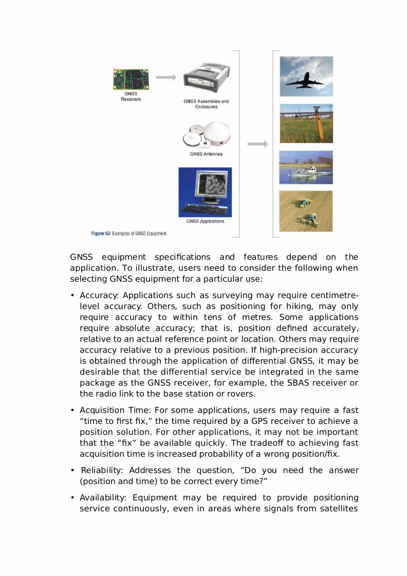
7/26/2019 teori gnss
http://slidepdf.com/reader/full/teori-gnss 71/73
(N e5uip*ent speci0cations and &eatures depend on the
application. o illustrate, users need to consider the &ollowing when
selecting (N e5uip*ent &or a particular use:
"ccuracy: "pplications such as sur%eying *ay re5uire centi*etreC
le%el accuracy. ?thers, such as positioning &or hiking, *ay only
re5uire accuracy to within tens o& *etres. o*e applications
re5uire absolute accuracyG that is, position de0ned accurately,
relati%e to an actual re&erence point or location. ?thers *ay re5uire
accuracy relati%e to a pre%ious position. I& highCprecision accuracy
is obtained through the application o& diFerential (N, it *ay be
desirable that the diFerential ser%ice be integrated in the sa*e
package as the (N recei%er, &or e-a*ple, the $" recei%er or
the radio link to the base station or ro%ers.
"c5uisition i*e: or so*e applications, users *ay re5uire a &ast
“ti*e to 0rst 0-,! the ti*e re5uired by a (7 recei%er to achie%e a
position solution. or other applications, it *ay not be i*portant
that the “0-! be a%ailable 5uickly. he tradeoF to achie%ing &ast
ac5uisition ti*e is increased probability o& a wrong positionO0-.
@eliability: "ddresses the 5uestion, “=o you need the answer
8position and ti*e) to be correct e%ery ti*eM!
"%ailability: 5uip*ent *ay be re5uired to pro%ide positioning
ser%ice continuously, e%en in areas where signals &ro* satellites

7/26/2019 teori gnss
http://slidepdf.com/reader/full/teori-gnss 72/73
are blocked. "s we ha%e discussed, these applications *ay best be
ser%ed by e5uip*ent that integrates (N and IN e5uip*ent.
5uip*ent *ay need to support *ultiple constellations and
&re5uencies, and *ay need to per&or* well in en%iron*ents
characteriHed by a high le%el o& *ultipath inter&erence. @e*e*ber,&ro* #hapter 2, *ultipath inter&erence occurs because so*e o& the
signal energy trans*itted by the satellite is reected 8and there&ore
delayed) on the way to the recei%er.
In the selection o& (N e5uip*ent, there will al*ost always be
tradeoFs between accuracy, ac5uisition ti*e, reliability, and
a%ailability.
n%iron*ental: 9ser e5uip*ent *ay ha%e to operate o%er wide
te*perature and hu*idity ranges, at high altitudes, or in dusty
en%iron*ents. he e5uip*ent *ay need to be waterproo& to rain or
sub*ersion.
hock and ibration: 5uip*ent *ay be subEected to high le%els o&
shock and %ibration, such as that which is characteristic o&
industrial %ehicles.
7ortability: =epending on the application, the e5uip*ent *ay need
to be handCheld 8hiking applications, &or e-a*ple) or portable.
@egulatory: @egulatory co*pliance will %ary with the Eurisdiction in
which the user is operating, &or e-a*ple:
*issions standards, such as ## 7art 1B.
#o*pliance with the uropean 9nion’s @estriction o& /aHardous
ubstances 8@o/) directi%e.
4, the uropean #o**unity directi%e that i*poses responsibility
&or the disposal o& waste electrical and electronic e5uip*ent on thee5uip*ent *anu&acturer.
=ata torage: @ecei%ers *ay be re5uired to store ti*eCsta*ped
range or position in&or*ation &or applications that will use this
in&or*ation postC*ission.
7hysical iHe and 7ower #onsu*ption: he user *ay re5uire a
recei%er or antenna with a s*all &or*C&actor and low power
consu*ption &or integration in a particular application.
9ser Inter&ace: he *anner through which the user interacts with
the e5uip*ent is i*portantG &or e-a*ple, a keypad &or entering
7/26/2019 teori gnss
http://slidepdf.com/reader/full/teori-gnss 73/73
co**ands, a screen &or %iewing position data on a *ap, or
connectors &or outputting data to other de%ices.
#o*putational @e5uire*ents: 9sers *ay re5uire that the
e5uip*ent pro%ide co*puted data such as %elocity or heading.
#o**unications: 7osition *ay only be use&ul i& it is co**unicated
to another de%ice o%er, &or e-a*ple, a cellular radio link.
utureC7roo&: "lthough so*e (N signals and constellations *ay
not yet be a%ailable, users *ay re5uire so*e assurance that they
will be able to use these signals and constellations once they are
a%ailable.
#losing @e*arks
“I used to think that cyberspace was 0&ty years away. 4hat I thoughtwas 0&ty years away, was only ten years away. "nd what I thought
was ten years away... it was already here. I Eust wasn’t aware o& it
yet.! $ruce terling, "*erican science 0ction author.
>ike “cyberspace,! (N is already here, and it has achie%ed broad
acceptance and application. Industry and go%ern*ent agencies are
continually enhancing technology and in&rastructure and de%eloping
new (NCbased solutions.In this chapter, we ha%e pro%ided a sa*pling o& (N applications
and e5uip*ent, to illustrate Eust how incredible (N is. "s costs are
reduced &urther, the (N space seg*ent enhanced, and new
positioning techni5ues concei%ed and i*ple*ented, &urther
applications and e5uip*ent will be de%eloped. 4e are witnessing the
early days o& the (N re%olution. (N technology will beco*e
ubi5uitous 6 a pre%alent, takenC&orCgranted technology in e%erything
we do.
u*ber http:OOwww.no%atel.co*OanCintroductionCtoCgnss
=iakses tanggal 2 Ean 2<1B