Embed Size (px)
Citation preview
The Baltic Maritime Heritage
– spatial atlas –
BalticRIM report - GoA 2.5
Magdalena Matczak, Jacek Zaucha, Susanne Altvater, Jakub Turski, Joanna Witkowska,
Maps: Joanna Pardus, Łukasz Szydłowski
Gdańsk, September 2019
Table of content
1. Introduction ..................................................................................................................................... 3
The importance of protecting and sustaining the maritime cultural heritage in the Baltic Sea Region
............................................................................................................................................................. 3
2. Maritime Spatial Planning and Maritime Cultural Heritage – so far experience in brief ................ 5
2.1. MSP definitions, historical shot, MSP practice in the Baltic Sea Region (BSR) ....................... 5
2.2. MSP & MCH current practise in BSR ....................................................................................... 7
2.3. Some challenges related to the integration of MCH in MSP ................................................... 9
2.4. MSP needs towards sectoral knowledge .............................................................................. 10
3. Let’s dive into Maritime Cultural Heritage in the Baltic Sea Region ............................................. 11
3.1. Types of Baltic MCH ............................................................................................................... 11
3.1.1 Wrecks ............................................................................................................................... 14
3.1.3 Other – lighthouses and naval battle areas ....................................................................... 23
3.2. Main threads to MCH ............................................................................................................ 25
3.3. Potential synergies/multi-use ............................................................................................... 31
3.4. From dots to areas - BalticRIM cultural “hot spots” – Baltic MCH priority areas ................. 34
4. Main messages and challenges towards maritime spatial planning ............................................. 36
5. Bibliography ................................................................................................................................... 39
1. Introduction
The importance of protecting and sustaining the maritime cultural heritage in the Baltic Sea Region
Maritime cultural heritage have not been properly protected in many Baltic countries so far.
The reason are numerous but among them the most important can be named as following:
a) Protection efforts are done at national level therefore protection standards and
ambitions differ whereas maritime cultural heritage belongs to the common heritage
of all Baltic nations.
b) There is lack of commonly agreed definition of maritime cultural heritage that can
guide the protective efforts whereas the actual composition of this category is very
diverse. This pose an intellectual difficulty for the users of the sea space that might
not be aware of negative impacts of their activities on maritime cultural heritage. The
practical adverse result is reduction of maritime cultural heritage to underwater
cultural heritage −mainly wrecks− and by that many other historical objects are
neglected.
c) Information on maritime cultural heritage is scarce and in many cases not easy to be
obtained. It requires costly research efforts that are done by few specialised public
agencies with limited budgets.
d) International law that provides bases for protection of maritime cultural heritage is
insufficient in particular in the exclusive economic zone (EEZ) and areas beyond
national jurisdiction. Moreover the enforcement of the existing law poses many
challenges and in majority of cases is based on a good will of users of the sea space
and their voluntary compliance to the existing rules.
Therefore protection of maritime cultural heritage would require co-operation of many sea
stakeholders including various public authorities, MGOs and private sector. The starting point
should be in education and information efforts in order to raise awareness of the aforesaid
stakeholders on the importance of maritime cultural heritage and the threats created for its
preservation due to intensification of the commercial usage of the sea areas. This atlas is a
part of such information strategy.
According to the Blue Growth strategy that has been recently put forward by the European
Commission, oceans hold the key to the future for the European Union and many nations
around the world. According to the OECD in 2010, the blue economy yielded global products
and services worth 1.5 trillion or 2.5% of world gross value added, providing 31 million jobs.
According to EU estimates Blue Economy established sectors provided employment for 4
million people in EU with an average salary €26,400 per annum, and contributed to the EU
economy with gross added value of €180 billion. New methods of reaping the benefits of the
sea has been emerging and the current ones are undergoing profound transformations. New
sectors such as off-shore renewable energy generation1, extraction of polymetallic nodules,
bio-tech or CO2 storage have just started to appear at the sea. All these creates threats for
the preservation of the maritime cultural heritage. But by the same there is the chance for
the maritime cultural heritage. It can be a part of the sustainable blue growth efforts and
blue growth can intensify the search and monitoring of the maritime cultural heritage.
One of the remedies to alleviate risks related to intensified usage of the sea space is maritime
spatial planning (MSP) introduced by EU in a form of MSP Directive in 2014. MSP should be
also seen as a chance for protection of maritime cultural heritage.
The focus of this report is to explore this chance and to make it true by creating a common
language and discussion platform between maritime spatial planners and officers responsible
for protection of maritime cultural heritage in the Baltic Sea Region (BSR) countries. The atlas
will not solve all the mentioned at the beginning problems related to preservation of the
Baltic maritime cultural heritage, but at least it hopefully will open and prompt the maritime
spatial planners towards the need of more careful approach on maritime cultural heritage.
Having this ambition in mind the atlas is prepared in line with the needs of the maritime
spatial planners making use of the planning vocabulary, dwelling on MSP documents and
putting visual language to the forefront.
The atlas is intended as a summary of BalticRIM Work Package 2 findings (GoA 2.1, 2.2, 2.3
and 2.4) creating the bridge between the historical knowledge and spatial planning. It was
projected to show the pan-Baltic potential of maritime cultural heritage, highlight the most
valuable areas, analyse the main threads and propose zoning solutions.
The report was also inspired with the Rutilus project 100-report and national MSP planning
documentations.
In the following, the term “Maritime Cultural Heritage” (MCH) is used connecting the so far
explored Underwater Cultural Heritage to the coastal zones with their historical aspects. The
term MCH reflects the linkage between MSP and integrated coastal zone management as well
as regional land planning.
It is planned to update the report by the end of the projects with the finding of BalticRIM
case-studies and updated maps.
1For instance employment in EU wind energy increased by 14% in one year (2016-17) (EC 2019, 3)
2. Maritime Spatial Planning and Maritime Cultural Heritage – so far
experience in brief
2.1. MSP definitions, historical shot, MSP practice in the Baltic Sea Region (BSR)
Maritime Spatial Planning (MSP) was initiated at EU-level as a practical planning task at the
beginning of the current century with the Baltic Sea region (BSR) as a forerunner. The starting
point of the introduction of the MSP idea to the BSR was the 5th HELCOM-VASAB Ministerial
Conference in Wismar in 2001. In the Wismar Declaration the Ministers responsible for spatial
planning and development in the countries of the BSR urged the HELCOM-VASAB MSP
Working Group2 to put in its future work emphasis on projects extending spatial planning also
to the off-shore side. The main reason that prompted VASAB to promote MSP was a fear of
acceleration of spatial conflicts over the use of maritime space resulting from increased
intensity of its exploitation and increasing new sea space uses (e.g. off-shore wind,
aquaculture for environment protection etc.). Following this plea, the pilot MSP plans were
elaborated in the BSR (in projects like BaltSeaPlan and Plancoast), and at the same time MSP
methodology was advanced in the PartiSEApate project. The East West Window3 project
served to inform Russia about MSP. The first binding maritime spatial plan in Europe was
elaborated in Mecklenburg-Vorpommern. The plan entered into force in 2005. Thus, one can
notice that the first decade of the current century in the BSR was devoted to define MSP and
accumulate experience on that.
According to a very popular definition by IOC-UNESCO4 ‘maritime spatial planning is a public
process of analysing and allocating the spatial and temporal distribution of human activities in
marine areas to achieve ecological, economic, and social objectives that are usually specified
through a political process’. VASAB, on the other hand, argues that the spatial planning of sea
areas should be treated as a legally defined hierarchical process of finding a compromise
between competing needs regarding the use of maritime space (the surface of the sea,
waters and the sea bottom) in accordance with values and objectives of a given community –
and those values and objectives can be found in international and state priorities and
agreements. The planning defined in such a fashion shapes and monitors spatial development
of sea areas with the application of proper instruments (for example, visions and strategies of
2 The joint Baltic Sea MSP Working Group, established by HELCOM and VASAB, is a forum for
intergovernmental discussions on MSP. The Working Group hosts dialogues on recent and future developments
in the field of MSP in the Baltic Sea Region.
3 EastWest Windiow (2007-2008) was an TACIS Project for the BSR which assisted VASAB in implementation of the tasks of the Sixths VASAB Ministerial Conference of 2005. The main aim of the East West Window project was to accelerate the Baltic Sea Region (BSR) development through better connecting of the existing potentials within the Region. 4 Eehler, Charles, and Fanny Douvere. Marine Spatial Planning: a step-by-step approach toward ecosystem-
based management. Intergovernmental Oceanographic Commission and Man and the Biosphere Programme.
IOC Manual and Guides no. 53, iCaM Dossier no. 6. Paris: UNESCO. 2009 (English).
spatial plans). Both definitions seem complementary since the first one describes the role of
the MSP whereas the second one puts focus on the MSP process.
Currently, the most frequently used is the EU definition of spatial planning of sea areas
derived from the EU MSP Directive5 which establishes the framework: according to it, ”spatial
planning of sea areas refers to a process through which appropriate organs of member states
analyse and organise human activity in sea areas in order to achieve ecological, economic and
social objectives”. This definition is very general and imprecise (spatial aspect is missing there)
but underlines the legal rights of the member states to conduct MSP.
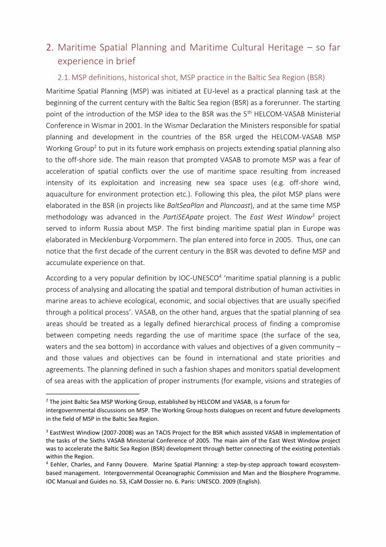
In Europe, the 23 coastal Member States are obliged under the MSP Directive to develop a
national maritime spatial plan
before 31 March 2021, with a
minimum review period of 10
years. The MSP Directive was
adopted in 2014 and establishes a
framework for MSP, ‘aimed at
promoting the sustainable growth
of maritime economies, the
sustainable development of marine
areas and the sustainable use of
marine resources.’
Across Europe, Member States are
currently, however, in different
phases of the MSP process, with
plans either in preparation,
adopted or in review, see Fig. 1.
Fig. 1: Overview of the current status of
MSP in the Baltic Sea Region with
differentiation between existing plans and
planning areas.
Source: EU MSP Platform
(https://www.msp-platform.eu/sea-
basins/baltic-sea-0)
5 Directive 2014/89/EU of the European Parliament and of the Council of 23 July 2014 establishing a framework
for maritime spatial planning

2.2. MSP & MCH current practise in BSR
Maritime cultural heritage was taken into consideration from the very beginning of MSP
development in the BSR. However, there were strong differences how it was done in practice.
The first complex approach for the EEZ was proposed in Poland. In the Pilot Maritime Spatial
Plan for the Western Part of the Gulf of Gdańsk specific prohibitions and requirements were
formulated with regard to the protection of MCH for each sea sub-area. Also in the pilot
maritime spatial plan for the Southern Middle Bank the following requirement was proposed:
„On requirement of the maritime administration, routes of linear infrastructure, location of
mining, research or production activities may be changed in order to protect objects of
cultural heritage against damage caused by installation, construction or mining works, or
during monitoring, repairs and dismounting in the future.” This proposal can be considered as
the first practical attempt to protect MCH in the EEZ where direct legal and applicable
instruments for the sea areas under limited national jurisdiction are absent.
The idea tested in the Middle Bank pilot plan was based on the assumption that MCH can be
protected in EEZ from damages, even caused by activities being under legal supervision of the
coastal state. This was the first time in the BSR that the idea, investments must be preceded
by an inventory of MCH in the area for which a mining license or permission for constructing
and use of artificial islands, structures or installations is issued, was spelled out during the
planning process. A solution was that if such objects are found during construction,
installation, monitoring, maintenance or repair works, appropriate organs of maritime
administration shall be informed, and location of the investment shall be changed to protect
the MCH against damage.
Also in other pilot plans MCH was taken into consideration. In Latvian, Lithuanian and Finnish
(Kymenlaakso) there are some references to ship wrecks, whereas in the Hiiumaa and
Saaremaa plans the maritime cultural heritage has been mentioned explicitly. Also in the
Bothnia Plan pilot underwater cultural heritage has been mapped and addressed. Only in
German plans for the EEZ and the federal state of Mecklenburg-Vorpommern (first binding
plans in the BSR), MCH was omitted. However, one can conclude that from the very begging
at least some BSR countries raised the issue of protection of MCH under MSP.
In June 2013 under the PartiSEApate project the workshop “ Maritime Spatial Planning as Tool
for Underwater Cultural Heritage Management in the Baltic Sea” was organised in Riga. The
main goal was to initiate pan-Baltic multi-sectoral stakeholder discussion on maritime spatial
planning establishment as management tool for underwater cultural heritage. This was the
first pan-Baltic meeting between people responsible for UCH protection and maritime spatial
planning community. The meeting allowed the identification of common points (synergies)
and challenges and also key conflicts between UCH and other sea uses. The main finding was
that in principle zoning should not be used as a key tool for the protection of all MCH under
MSP. Zoning or designation of MCH protection areas could be applicable just in some cases,

for example, to protect prehistoric landscapes and sandbanks with a magnitude of wrecks.
Instead, methods or strict rules have to be developed, how to consider MCH, when issuing
permits for new and MCH impacting activities in the sea.
The following conclusions were formulated by the workshop:
1. MCH sector was not considered and involved in MSP development projects up to now
at equal extent compared to other sea use sectors.
2. MCH sector has to be involved and considered in MSP development at pan- Baltic
scale taking into account the different legal situations and natural conditions in BSR
region.
3. MCH sector in BSR has already cooperation platform at pan- Baltic level - working
group on UCH established under CBSS. In future cooperation between CBSS WG on
UCH and VASAB working on MSP issues at pan-Baltic level is recommended.
4. MCH protection goals conflict almost with all sectors. At the same time the co-
operation and synergies with other sectors are possible. However, a system for
information exchange between the MCH sector and other sectors has to be developed
and MSP could be used as a tool for such cooperation.
5. Spatial solutions (such as zoning / sites designation) to present MCH interests in MSP
have to be more discussed within the sector and with planners at pan-Baltic level.
6. There is no information about all existing MCH assets under the water, since they are
not all discovered and scientific research on potential impact from newly developing
sectors in the sea, like offshore wind parks and particular infrastructure, aquaculture,
pipelines etc. is missing or not sufficient. Therefore the precautionary principle has to
be taken into account.
Currently, MSP is rapidly progressing in the BSR. In Mecklenburg-Vorpommern maritime
spatial plan of the second generation was adopted in 2016. In this plan UCH has been
considered but not directly regulated. Also the revision of the German Baltic EEZ maritime
spatial plan has been started. Officially adopted spatial plans do exist also in Estonia, Finland
(both regional level), Latvia and Lithuania (both national level). In the Latvian plan, cultural
monuments are identified although they are not regulated under MSP directly (sectoral law
applies).
One of the key objectives of the Lithuanian plan is to protect, restore and rationally use
resources of nature and recreation, values of natural and cultural heritage.
Also Poland in Sweden have almost finished their national maritime spatial plans that are
subject to intergovernmental coordination. In both countries MCH was comprehensively
assessed in the stock taking reports both in terms of its existence and possible spatial conflicts
(Swedish: Maritime Spatial Planning —Current Status 2014 and Polish: Study of Conditions of
Spatial Development of Polish Sea Areas). This knowledge has informed the planning
solutions. For instance, in the Polish plan the rules on protection of MCH were introduced
promoting in-situ protection and the places were designated to store MCH objects that
cannot be protected in-situ. In the Polish plan MCH is treated as a full-scale sea use, although
in many cases regulated by specific legal regulations outside MSP - but which should be taken
into consideration when elaborating MSP solutions.
Estonia presented its draft national maritime spatial plan in 2019. In this plan MCH was
mapped and analysed and planning priorities guidelines and requirements have been
formulated with regard to UCH. Among others, the Estonian draft plan stipulates that in areas
of cultural monuments (the object together with the protected zone), anchorage, trawling,
deepening and dumping of solid material is prohibited. Other activities (e.g. fishing, diving)
are allowed only if they do not damage the cultural heritage. The main objective of the
protection of underwater monuments in Estonia is to ensure their preservation at their initial
location. National planning in Denmark and Finland is on the early stage to allow its
evaluation with regard to UCH approach. The progress in the BSR MSP is depicted in the
figure 1.
2.3. Some challenges related to the integration of MCH in MSP
Based on the current MSP processes in the BSR, some first lessons-learned can be derived:
• In the EEZ, MCH has to be taken into account, but the first real consideration
takes place in the framework of the sub-soil investigations (for example, for
corridors, routes for cables, etc.) only which is quite late.
• It would be better if, as with gravel quarrying, it had previously regulated how
to handle finds in order not to have to carry out investigations, gather data
and seek individual solutions for every single real project planning.
What should be changed regarding current practices?
• Include MCH aspects from the very beginning; provide priority areas or
reserved areas and describe these areas as text (not only as topic-specific
annex),
• Use on-going processes to finalise national / regional MSPs and negotiate
directly with the authorities,
• Share cross-border views and foster exchange of information,
• Use ecosystem-based-approaches to use synergies between nature
protection, MCH and tourism.
• Certain areas are identified from the outset as "areas of interest" for which
certain requirements are made in order to have control specifications at hand.
For the planner is therefore important to know where which MCH lies. In
some countries, MSP authorities do not know these locations and cannot
work accordingly with these data
• A transnational database, e.g. for DE-DK or DE-PL would be very helpful to
coordinate protection and integration of MCH into plans.
It is therefore crucial that BalticRIM can give impetus to make specifications for the planning
in the sea before real project planning.

2.4. MSP needs towards sectoral knowledge
Please note: This chapter will be further developed after having received findings of report
2.3.
• MCH data gaps
• Categorization and classification of MCH
3. Let’s dive into Maritime Cultural Heritage in the Baltic Sea Region
3.1. Types of Baltic MCH
The BalticRIM project is a reaction of the Baltic maritime culture world to the rapid growth of
the human activities on the sea areas, often on cumulating and unpredictable dimensions.
One of the main goals of the project is to make maritime spatial planners aware of the
importance of the Baltic Sea for cultural heritage, to develop cultural heritage information
and to disseminate knowledge so that maritime heritage can be properly taken into account
in the planning process. Within this chapter we tried to capture the picture of the most
important and characteristic Baltic cultural assets, based on projects finding as well as earlier
projects and on-going national MSP processes.
The Baltic maritime cultural heritage is still to a great extend undiscovered regarding
underwater component. The main problems is limited accessibility and lack of systematic
archaeological research of marine areas probably mainly due to the financial resources.
According to the Rutilius Report (2006) there are some 15,500 registered underwater sites of
cultural heritage value in the Baltic Sea, nevertheless it is estimated that the real number only
of the UCH sites in the Baltic Sea is close to 100,000 (Fig. 2). In 2006, almost 9,000 of these
sites have been designated as national monuments. The BalticRIM project shows the rise of
registered sites up to 1000.
Fig. 2: Map of registered underwater cultural sites located in Danish, German, Swedish, Aland, Finnish, Polish and Lithuanian waters. Sites in Estonia, Russia and Latvia are inserted very approximately. Source: Rutilis Report 2006.
Fig. 3. An overview of the approximate locations for the “100” most valuable underwater cultural heritage sites in the Baltic Sea region.
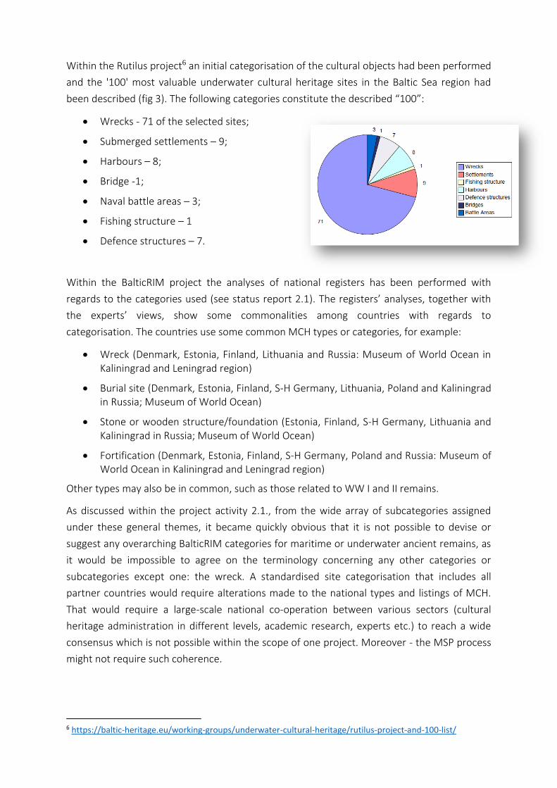
Within the Rutilus project6 an initial categorisation of the cultural objects had been performed
and the '100' most valuable underwater cultural heritage sites in the Baltic Sea region had
been described (fig 3). The following categories constitute the described “100”:
• Wrecks - 71 of the selected sites;
• Submerged settlements – 9;
• Harbours – 8;
• Bridge -1;
• Naval battle areas – 3;
• Fishing structure – 1
• Defence structures – 7.
Within the BalticRIM project the analyses of national registers has been performed with
regards to the categories used (see status report 2.1). The registers’ analyses, together with
the experts’ views, show some commonalities among countries with regards to
categorisation. The countries use some common MCH types or categories, for example:
• Wreck (Denmark, Estonia, Finland, Lithuania and Russia: Museum of World Ocean in Kaliningrad and Leningrad region)
• Burial site (Denmark, Estonia, Finland, S-H Germany, Lithuania, Poland and Kaliningrad in Russia; Museum of World Ocean)
• Stone or wooden structure/foundation (Estonia, Finland, S-H Germany, Lithuania and Kaliningrad in Russia; Museum of World Ocean)
• Fortification (Denmark, Estonia, Finland, S-H Germany, Poland and Russia: Museum of World Ocean in Kaliningrad and Leningrad region)
Other types may also be in common, such as those related to WW I and II remains.
As discussed within the project activity 2.1., from the wide array of subcategories assigned
under these general themes, it became quickly obvious that it is not possible to devise or
suggest any overarching BalticRIM categories for maritime or underwater ancient remains, as
it would be impossible to agree on the terminology concerning any other categories or
subcategories except one: the wreck. A standardised site categorisation that includes all
partner countries would require alterations made to the national types and listings of MCH.
That would require a large-scale national co-operation between various sectors (cultural
heritage administration in different levels, academic research, experts etc.) to reach a wide
consensus which is not possible within the scope of one project. Moreover - the MSP process
might not require such coherence.
6 https://baltic-heritage.eu/working-groups/underwater-cultural-heritage/rutilus-project-and-100-list/
It has been recommended, however, (see status report GoA2.2) to develop simple categories,
not violating any national register system and helping the initial description and
categorisation of data.
The recommended categories contain:
1. Wreck (shipwreck or a plane wreck);
2. Remains of settlement;
3. Remains of hydro-technical structures;
4. Other.
This division is not violating any national system as it only defines the original function of the
given object. For example, a shipwreck may constitute remains of a sailing vessel, a secondary
used element of a barrier, a hydro-technical construction or a burial place. The function of the
object in the deposition phase does not interfere with its basic form.
Therefore, due to the described encountered obstacles influencing the MCH data
categorisation, the further analysis is based on reports that individual countries have
prepared as part of planning processes, as they indicate which categories are the most
important or most represented in a given country.
3.1.1 Wrecks
Wrecks constitute so far the most numerous category of the underwater cultural heritage,
which does not means that the most valuable. There is a great variety in the wrecks’ origin,
influencing their value. Still for the purposes of the spatial planning the most important is the
knowledge of the location and potential protections needs. The origin of Baltic wrecks is
deeply connected with the trading flows experiencing the Baltic Sea from the VIII century, e.g.
the Vikings, the Hanseatic League, the Dutch sailors then the internal Baltic wars for
hegemony of various nations. Their distribution reflects different periods in the history of the
Region.
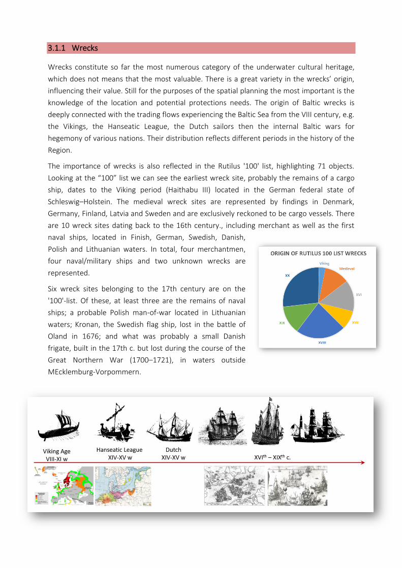
The importance of wrecks is also reflected in the Rutilus '100' list, highlighting 71 objects.
Looking at the “100” list we can see the earliest wreck site, probably the remains of a cargo
ship, dates to the Viking period (Haithabu III) located in the German federal state of
Schleswig–Holstein. The medieval wreck sites are represented by findings in Denmark,
Germany, Finland, Latvia and Sweden and are exclusively reckoned to be cargo vessels. There
are 10 wreck sites dating back to the 16th century., including merchant as well as the first
naval ships, located in Finish, German, Swedish, Danish,
Polish and Lithuanian waters. In total, four merchantmen,
four naval/military ships and two unknown wrecks are
represented.
Six wreck sites belonging to the 17th century are on the
'100'-list. Of these, at least three are the remains of naval
ships; a probable Polish man-of-war located in Lithuanian
waters; Kronan, the Swedish flag ship, lost in the battle of
Oland in 1676; and what was probably a small Danish
frigate, built in the 17th c. but lost during the course of the
Great Northern War (1700–1721), in waters outside
MEcklemburg-Vorpommern.
Looking at the spatial distribution of the Baltic wrecks we can use the information and
visualisations prepared by during the national planning processes.
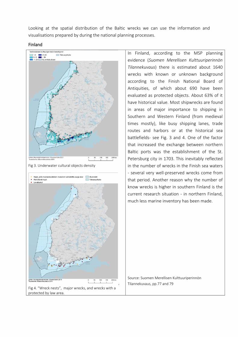
Finland
Fig 3. Underwater cultural objects density
, Fig 4. “Wreck nests”, major wrecks, and wrecks with a protected by law area.
In Finland, according to the MSP planning
evidence (Suomen Merellisen Kulttuuriperinnön
Tilannekuvaus) there is estimated about 1640
wrecks with known or unknown background
according to the Finish National Board of
Antiquities, of which about 690 have been
evaluated as protected objects. About 63% of it
have historical value. Most shipwrecks are found
in areas of major importance to shipping in
Southern and Western Finland (from medieval
times mostly), like busy shipping lanes, trade
routes and harbors or at the historical sea
battlefields- see Fig. 3 and 4. One of the factor
that increased the exchange between northern
Baltic ports was the establishment of the St.
Petersburg city in 1703. This inevitably reflected
in the number of wrecks in the Finish sea waters
- several very well-preserved wrecks come from
that period. Another reason why the number of
know wrecks is higher in southern Finland is the
current research situation - in northern Finland,
much less marine inventory has been made.
Source: Suomen Merellisen Kulttuuriperinnön
Tilannekuvaus, pp.77 and 79
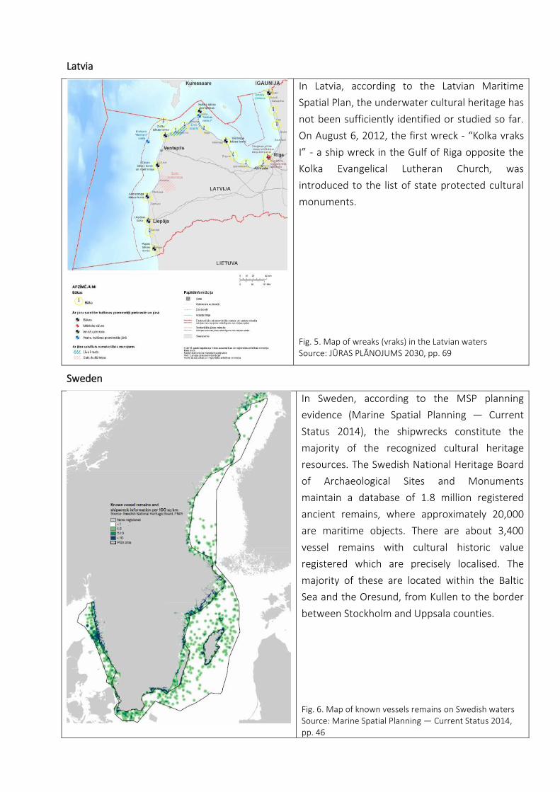
Latvia
In Latvia, according to the Latvian Maritime
Spatial Plan, the underwater cultural heritage has
not been sufficiently identified or studied so far.
On August 6, 2012, the first wreck - “Kolka vraks
I” - a ship wreck in the Gulf of Riga opposite the
Kolka Evangelical Lutheran Church, was
introduced to the list of state protected cultural
monuments.
Fig. 5. Map of wreaks (vraks) in the Latvian waters Source: JŪRAS PLĀNOJUMS 2030, pp. 69
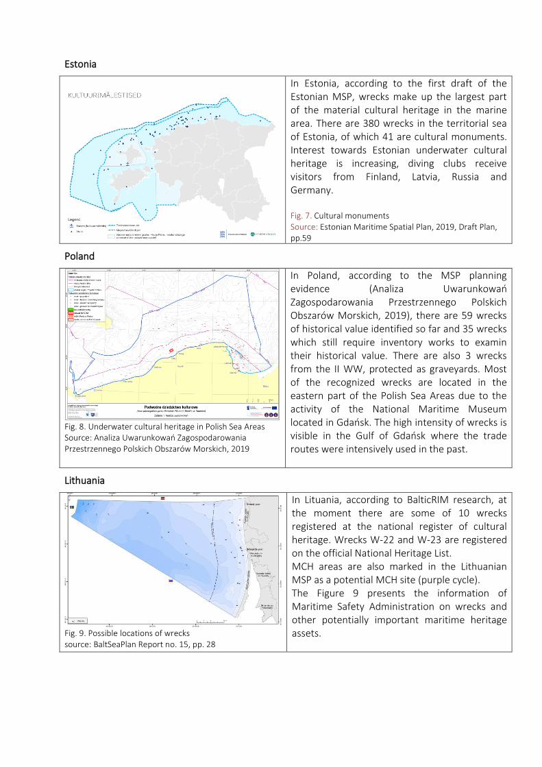
Sweden
In Sweden, according to the MSP planning
evidence (Marine Spatial Planning — Current
Status 2014), the shipwrecks constitute the
majority of the recognized cultural heritage
resources. The Swedish National Heritage Board
of Archaeological Sites and Monuments
maintain a database of 1.8 million registered
ancient remains, where approximately 20,000
are maritime objects. There are about 3,400
vessel remains with cultural historic value
registered which are precisely localised. The
majority of these are located within the Baltic
Sea and the Oresund, from Kullen to the border
between Stockholm and Uppsala counties.
Fig. 6. Map of known vessels remains on Swedish waters Source: Marine Spatial Planning — Current Status 2014, pp. 46
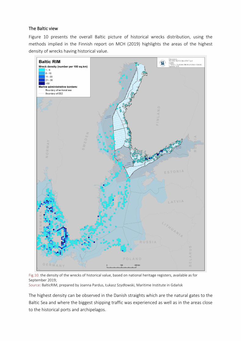
Estonia
In Estonia, according to the first draft of the Estonian MSP, wrecks make up the largest part of the material cultural heritage in the marine area. There are 380 wrecks in the territorial sea of Estonia, of which 41 are cultural monuments. Interest towards Estonian underwater cultural heritage is increasing, diving clubs receive visitors from Finland, Latvia, Russia and Germany. Fig. 7. Cultural monuments Source: Estonian Maritime Spatial Plan, 2019, Draft Plan, pp.59
Poland
Fig. 8. Underwater cultural heritage in Polish Sea Areas Source: Analiza Uwarunkowań Zagospodarowania Przestrzennego Polskich Obszarów Morskich, 2019
In Poland, according to the MSP planning evidence (Analiza Uwarunkowań Zagospodarowania Przestrzennego Polskich Obszarów Morskich, 2019), there are 59 wrecks of historical value identified so far and 35 wrecks which still require inventory works to examin their historical value. There are also 3 wrecks from the II WW, protected as graveyards. Most of the recognized wrecks are located in the eastern part of the Polish Sea Areas due to the activity of the National Maritime Museum located in Gdańsk. The high intensity of wrecks is visible in the Gulf of Gdańsk where the trade routes were intensively used in the past.
Lithuania
Fig. 9. Possible locations of wrecks source: BaltSeaPlan Report no. 15, pp. 28
In Lituania, according to BalticRIM research, at the moment there are some of 10 wrecks registered at the national register of cultural heritage. Wrecks W-22 and W-23 are registered on the official National Heritage List. MCH areas are also marked in the Lithuanian MSP as a potential MCH site (purple cycle). The Figure 9 presents the information of Maritime Safety Administration on wrecks and other potentially important maritime heritage assets.
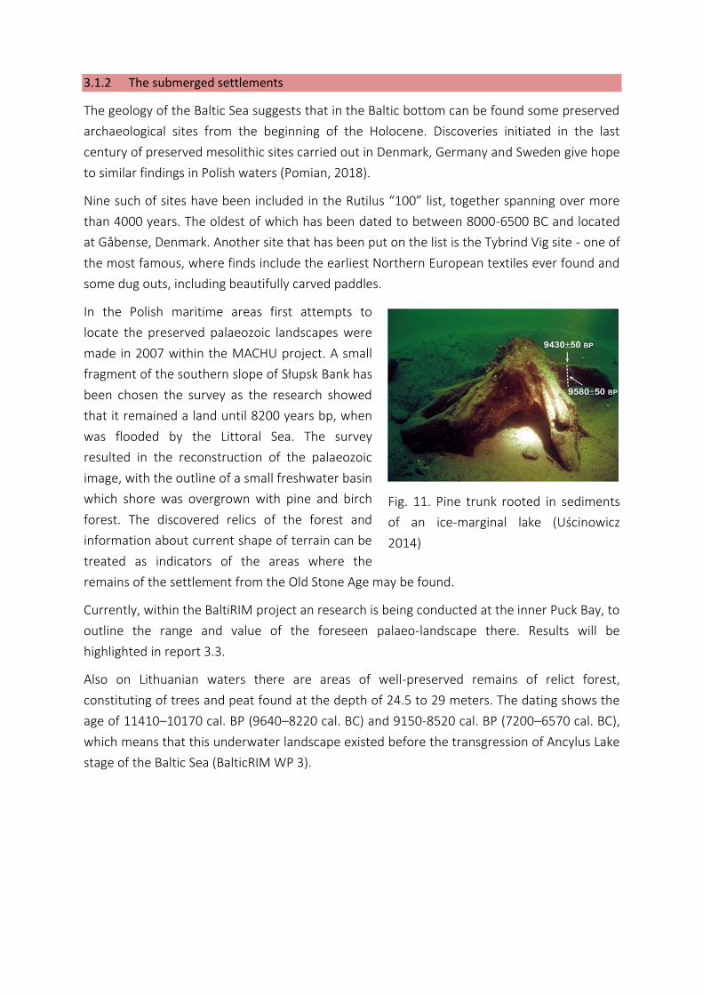
The Baltic view
Figure 10 presents the overall Baltic picture of historical wrecks distribution, using the
methods implied in the Finnish report on MCH (2019) highlights the areas of the highest
density of wrecks having historical value.
Fig.10. the density of the wrecks of historical value, based on national heritage registers, available as for September 2019; Source: BalticRIM, prepared by Joanna Pardus, Łukasz Szydłowski, Maritime Institute in Gdańsk
The highest density can be observed in the Danish straights which are the natural gates to the
Baltic Sea and where the biggest shipping traffic was experienced as well as in the areas close
to the historical ports and archipelagos.
3.1.2 The submerged settlements
The geology of the Baltic Sea suggests that in the Baltic bottom can be found some preserved
archaeological sites from the beginning of the Holocene. Discoveries initiated in the last
century of preserved mesolithic sites carried out in Denmark, Germany and Sweden give hope
to similar findings in Polish waters (Pomian, 2018).
Nine such of sites have been included in the Rutilus “100” list, together spanning over more
than 4000 years. The oldest of which has been dated to between 8000-6500 BC and located
at Gåbense, Denmark. Another site that has been put on the list is the Tybrind Vig site - one of
the most famous, where finds include the earliest Northern European textiles ever found and
some dug outs, including beautifully carved paddles.
In the Polish maritime areas first attempts to
locate the preserved palaeozoic landscapes were
made in 2007 within the MACHU project. A small
fragment of the southern slope of Słupsk Bank has
been chosen the survey as the research showed
that it remained a land until 8200 years bp, when
was flooded by the Littoral Sea. The survey
resulted in the reconstruction of the palaeozoic
image, with the outline of a small freshwater basin
which shore was overgrown with pine and birch
forest. The discovered relics of the forest and
information about current shape of terrain can be
treated as indicators of the areas where the
remains of the settlement from the Old Stone Age may be found.
Currently, within the BaltiRIM project an research is being conducted at the inner Puck Bay, to
outline the range and value of the foreseen palaeo-landscape there. Results will be
highlighted in report 3.3.
Also on Lithuanian waters there are areas of well-preserved remains of relict forest,
constituting of trees and peat found at the depth of 24.5 to 29 meters. The dating shows the
age of 11410–10170 cal. BP (9640–8220 cal. BC) and 9150-8520 cal. BP (7200–6570 cal. BC),
which means that this underwater landscape existed before the transgression of Ancylus Lake
stage of the Baltic Sea (BalticRIM WP 3).
Fig. 11. Pine trunk rooted in sediments
of an ice-marginal lake (Uścinowicz
2014)
The Baltic View
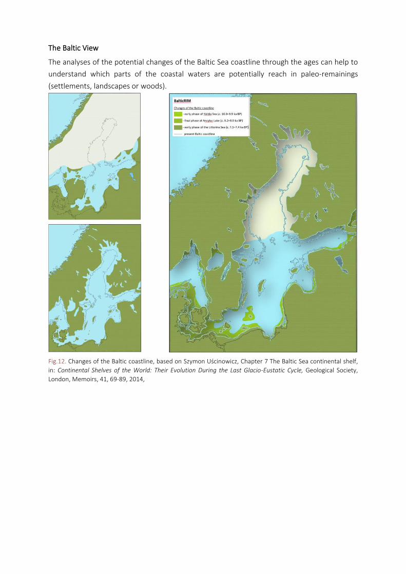
The analyses of the potential changes of the Baltic Sea coastline through the ages can help to
understand which parts of the coastal waters are potentially reach in paleo-remainings
(settlements, landscapes or woods).
Fig.12. Changes of the Baltic coastline, based on Szymon Uścinowicz, Chapter 7 The Baltic Sea continental shelf,
in: Continental Shelves of the World: Their Evolution During the Last Glacio-Eustatic Cycle, Geological Society,
London, Memoirs, 41, 69-89, 2014,
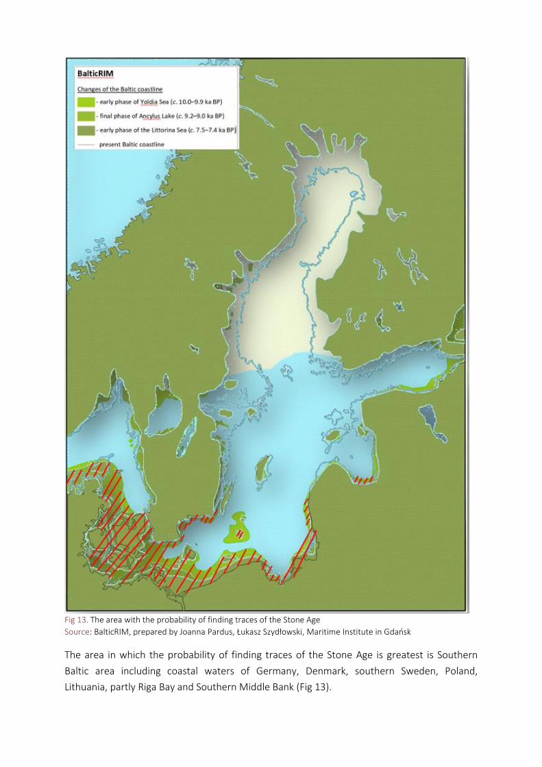
Fig 13. The area with the probability of finding traces of the Stone Age
Source: BalticRIM, prepared by Joanna Pardus, Łukasz Szydłowski, Maritime Institute in Gdańsk
The area in which the probability of finding traces of the Stone Age is greatest is Southern
Baltic area including coastal waters of Germany, Denmark, southern Sweden, Poland,
Lithuania, partly Riga Bay and Southern Middle Bank (Fig 13).
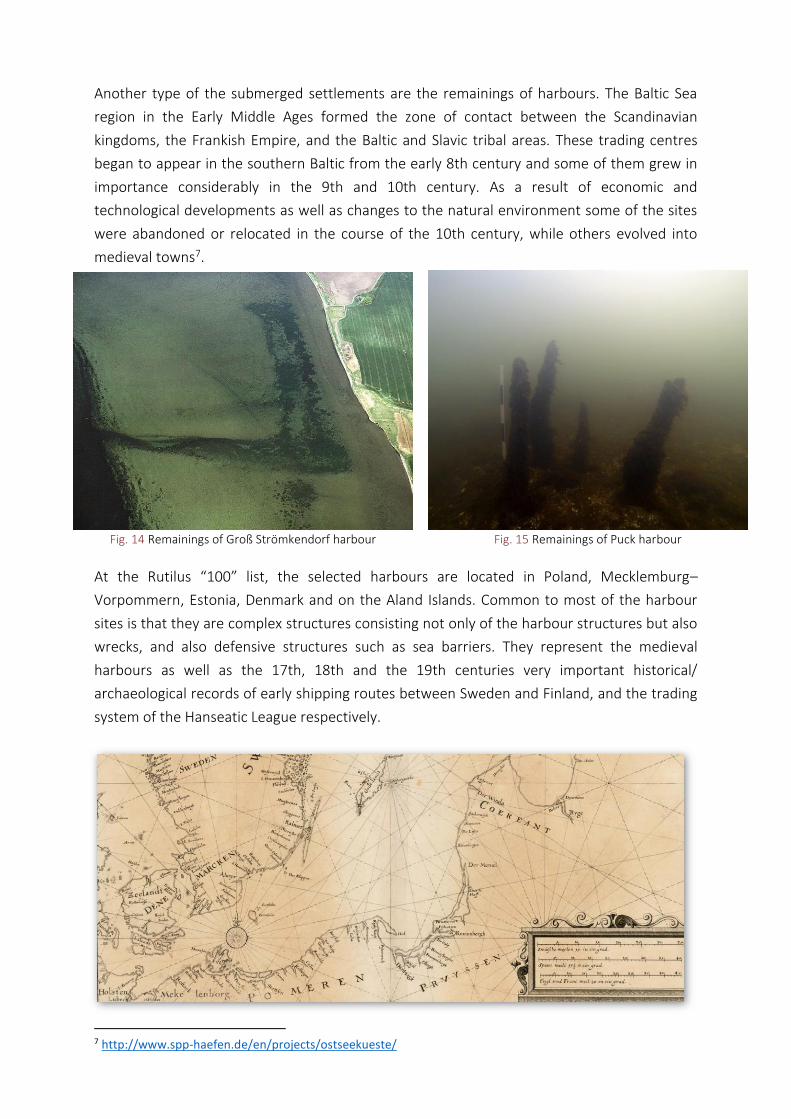
Another type of the submerged settlements are the remainings of harbours. The Baltic Sea
region in the Early Middle Ages formed the zone of contact between the Scandinavian
kingdoms, the Frankish Empire, and the Baltic and Slavic tribal areas. These trading centres
began to appear in the southern Baltic from the early 8th century and some of them grew in
importance considerably in the 9th and 10th century. As a result of economic and
technological developments as well as changes to the natural environment some of the sites
were abandoned or relocated in the course of the 10th century, while others evolved into
medieval towns7.
Fig. 14 Remainings of Groß Strömkendorf harbour Fig. 15 Remainings of Puck harbour
At the Rutilus “100” list, the selected harbours are located in Poland, Mecklemburg–
Vorpommern, Estonia, Denmark and on the Aland Islands. Common to most of the harbour
sites is that they are complex structures consisting not only of the harbour structures but also
wrecks, and also defensive structures such as sea barriers. They represent the medieval
harbours as well as the 17th, 18th and the 19th centuries very important historical/
archaeological records of early shipping routes between Sweden and Finland, and the trading
system of the Hanseatic League respectively.
7 http://www.spp-haefen.de/en/projects/ostseekueste/
3.1.3 Other – lighthouses and naval battle areas
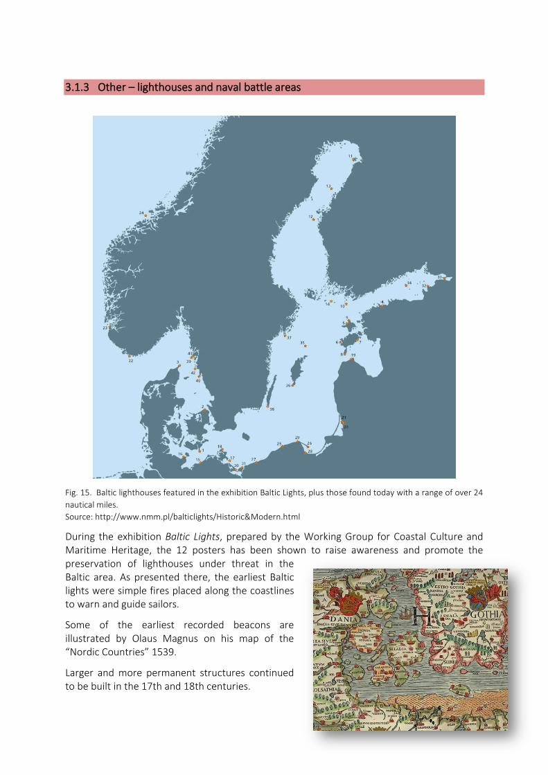
Fig. 15. Baltic lighthouses featured in the exhibition Baltic Lights, plus those found today with a range of over 24
nautical miles.
Source: http://www.nmm.pl/balticlights/Historic&Modern.html
During the exhibition Baltic Lights, prepared by the Working Group for Coastal Culture and Maritime Heritage, the 12 posters has been shown to raise awareness and promote the preservation of lighthouses under threat in the Baltic area. As presented there, the earliest Baltic lights were simple fires placed along the coastlines to warn and guide sailors.
Some of the earliest recorded beacons are illustrated by Olaus Magnus on his map of the “Nordic Countries” 1539.
Larger and more permanent structures continued to be built in the 17th and 18th centuries.
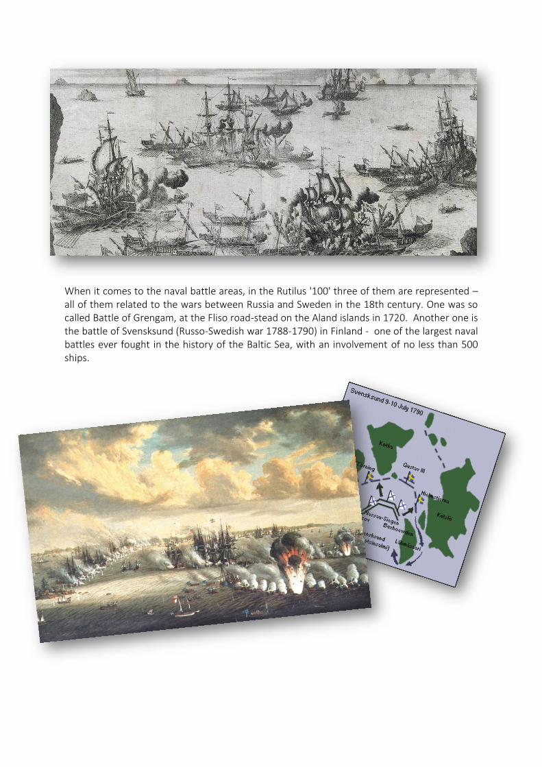
When it comes to the naval battle areas, in the Rutilus '100' three of them are represented – all of them related to the wars between Russia and Sweden in the 18th century. One was so called Battle of Grengam, at the Fliso road-stead on the Aland islands in 1720. Another one is the battle of Svensksund (Russo-Swedish war 1788-1790) in Finland - one of the largest naval battles ever fought in the history of the Baltic Sea, with an involvement of no less than 500 ships.

3.2. Main threads to MCH
The identification of synergic and conflicting uses with MCH is of high importance when
planning in areas including such resources. The thorough recognition of such phenomena
within the MSP process may ensure that conflicts and threats are avoided and MCH potential
is correctly protected and sustained for present and future generations.
It have to stated clearly, that every site of cultural value should be analysed at adequate scale,
taking into consideration local conditions and treads. Of course such systematic analyses are
not possible at the pan-Baltic scale, still it is useful to have a more wide overview of problems
when deciding on the planning solutions.
According to the existing literature, practical experience and the discussions held within the
BalticRIM project, the maritime activities affecting or damaging the underwater cultural
heritage objects are mainly those having negative impact on the bottom or near bottom
areas. As the maritime spatial planning regulates human activities, the environmental treads,
like changes in salinity, pH, currents, changes in biota and other climate change factors, will
not be analysed here.
The human activities affecting the underwater cultural objects are mainly:
• All types of construction reaching the seabed (drilling platforms, energy production,
touristic constructions, bridges, ports enlargements)
• Installations (pipelines, cables, etc.) laid at the bottom or immersed
• Certain fishing techniques (e.g., bottom-trawling, near-bottom trawling)
• Military and defence exercises and activities
• Bottom surface extraction (sand and other surface mined minerals)
• Coastal protection
• Intense tourism (boating, looting, careless anchoring, careless scuba diving, etc.);
The table below shows the initial MSP conflicts table prepared during the national MSP
process in Poland, based on the discussions with experts and stakeholders.
Tab. 1. Matrix based on Polish conflicts analyses for MSP, 2015
SECTOR
energy Mineral extraction
fishery Linear infr.
ship
pin
g
ports tourism National defence
Coastal protection
mar
icu
ltu
re
Deposit areas
wav
e
Hea
tin
g
syst
ems*
win
d
aggr
egat
es
O&
G e
xplo
rati
on
O&
G e
xplo
itat
ion
pas
sive
bo
tto
m
pel
agic
cab
les
pip
elin
es
con
stru
ctio
ns
dre
ggin
g
Bat
hin
g p
lace
s
Wat
er s
po
rts
div
ing
Trai
nn
g ar
eas
tory
MW
lotn
ictw
o
trw
ałe
nie
trw
ałe
Dre
ggin
g
Du
mp
ed
amu
nit
ion
UCH
A key problem is that the existing procedures are not protecting UCH from damage, especially
if UCH is not put on the navigation maps. Existing law do not protect UCH in the EEZ to the
necessary extent. The UNESCO Convention on the Protection of the Underwater Cultural
Heritage has not been signed by all BSR countries.8 There are many evidences of problems
with the preservation of UCH, which are still in the good condition. Incidental damage can be
caused by anchorage or bottom trawling even without noticing it. But also during the more
carefully prepared investment processes UCH is under severe risks since its protection might
delay investment processes resulting into high, unexpected additional expenses of the private
developer. Moreover UCH is under risk of tourism since wrack diving has become very
popular and its monitoring is still unsatisfactory. To recognize the most emerging problems
resulting from human activities development, the recent sectoral scenarios analyses and
HELCOM cumulative impacts assessments could be used.
8 Currently it has been ratified only by Lithuania out of 9 BSR coastal states
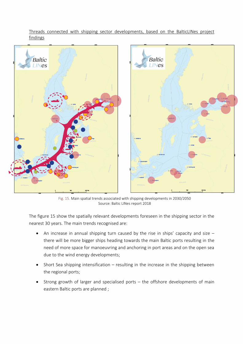
Threads connected with shipping sector developments, based on the BalticLINes project findings
Fig. 15. Main spatial trends associated with shipping developments in 2030/2050
Source: Baltic LINes report 2018
The figure 15 show the spatially relevant developments foreseen in the shipping sector in the
nearest 30 years. The main trends recognised are:
• An increase in annual shipping turn caused by the rise in ships’ capacity and size –
there will be more bigger ships heading towards the main Baltic ports resulting in the
need of more space for manoeuvring and anchoring in port areas and on the open sea
due to the wind energy developments;
• Short Sea shipping intensification – resulting in the increase in the shipping between
the regional ports;
• Strong growth of larger and specialised ports – the offshore developments of main
eastern Baltic ports are planned ;
• Growing offshore service – resulting in the increase or creation of the new shipping
patterns between the small regional ports and offshore constructions (during building
and servicing)
• Autonomous shipping – resulting in the need of separate shipping routes and more
space in the ports areas
The foreseen shipping sector development in general should not affect the MCH assets as the
main shipping patterns should not change and the most intense areas are regulated by IMO
measures. The main negative effects could be experienced in the areas of offshore ports
developments, where the in situ protection of the historical wrecks or historical ports’
remaining can be a problem. Ports developments can also negatively influence the historical
maritime landscape of the surroundings, especially in small gulfs and archipelagos, where new
port’s constructions and new anchoring places may interfere with the exposition of cultural
assets (lighthouses, old granaries, etc.).
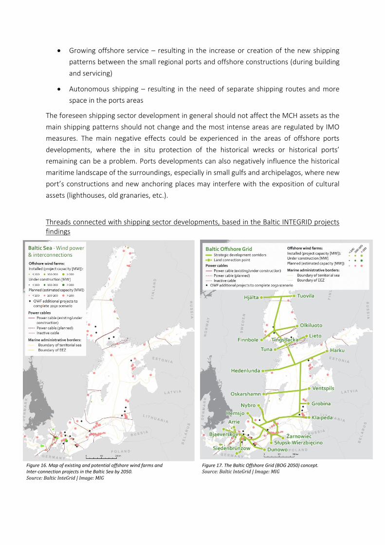
Threads connected with shipping sector developments, based in the Baltic INTEGRID projects findings
Figure 16. Map of existing and potential offshore wind farms and Inter-connection projects in the Baltic Sea by 2050. Source: Baltic InteGrid | Image: MIG
Figure 17. The Baltic Offshore Grid (BOG 2050) concept. Source: Baltic InteGrid | Image: MIG
The figures 16 and 17 show the developments foreseen in the electric linear infrastructure in
the nearest 30 years. The main trend recognised is the strong increase in the cable laying, due
to the offshore wind energy production increase almost in all the countries and planned
international energy connectors. One of the solutions proposed to minimize the bottom
impacts of such developments is to connect the groups of wind farms with on-land grids with
one corridor, still one have to be aware that such solution can not be applied everywhere due
to the technical problems. The worst scenario is to connect every single wind farm
individually, which may cause strong disturbance of huge bottom areas in the coastal zones.
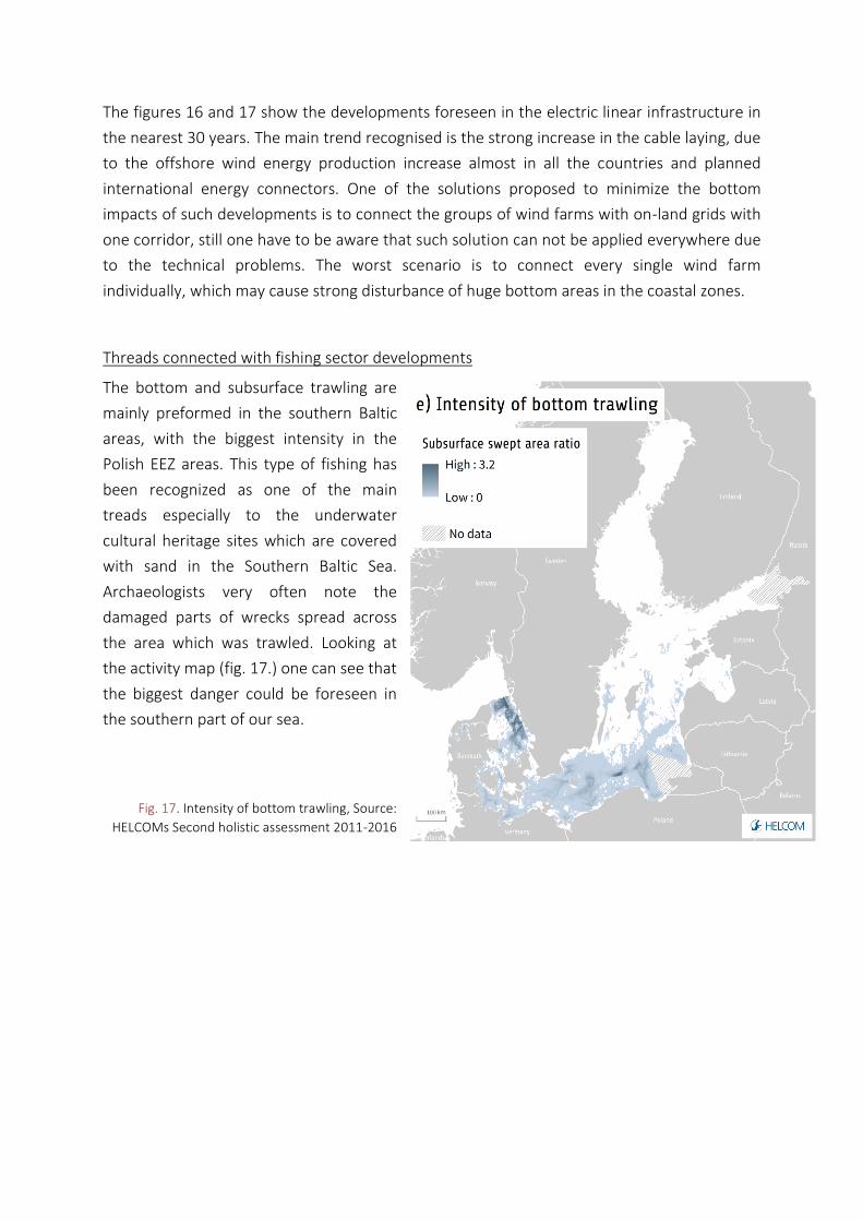
Threads connected with fishing sector developments
The bottom and subsurface trawling are
mainly preformed in the southern Baltic
areas, with the biggest intensity in the
Polish EEZ areas. This type of fishing has
been recognized as one of the main
treads especially to the underwater
cultural heritage sites which are covered
with sand in the Southern Baltic Sea.
Archaeologists very often note the
damaged parts of wrecks spread across
the area which was trawled. Looking at
the activity map (fig. 17.) one can see that
the biggest danger could be foreseen in
the southern part of our sea.
Fig. 17. Intensity of bottom trawling, Source:
HELCOMs Second holistic assessment 2011-2016
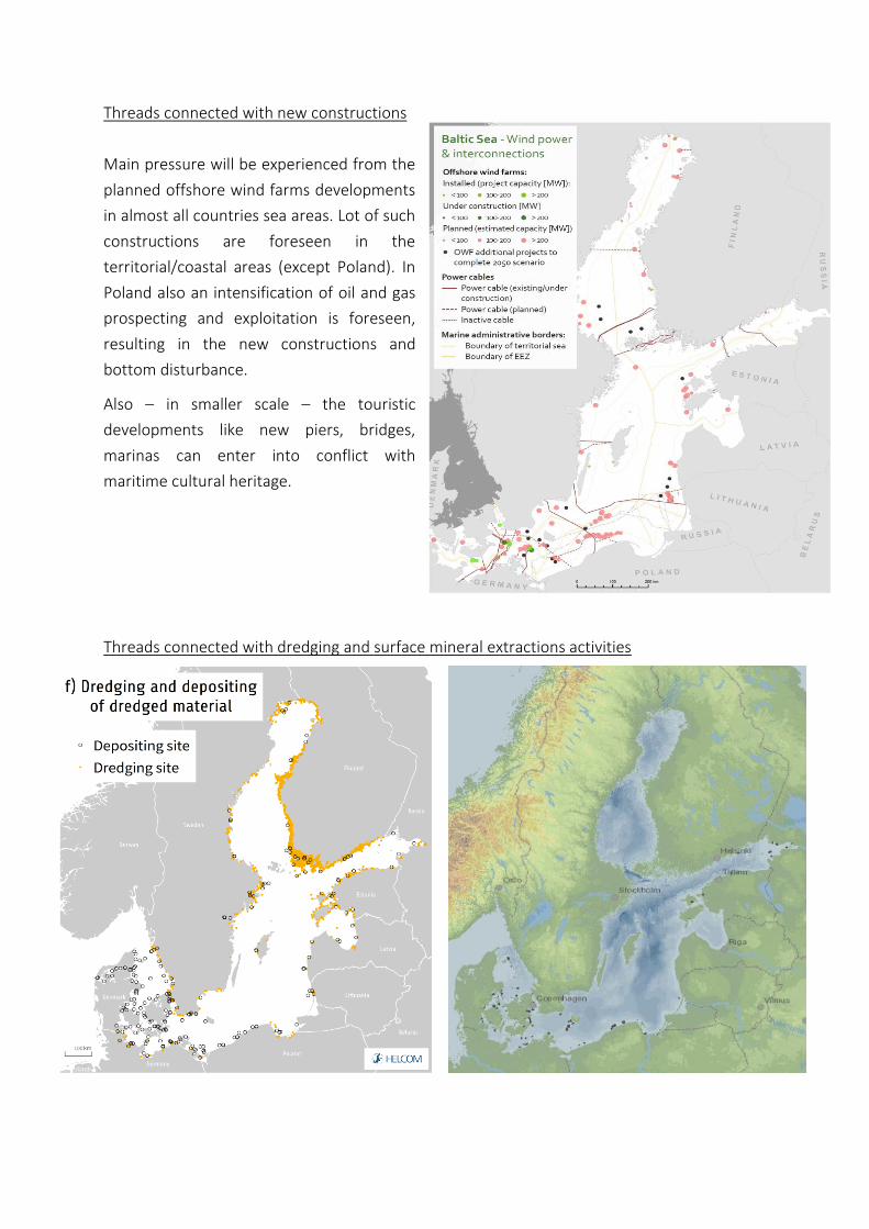
Threads connected with new constructions
Main pressure will be experienced from the
planned offshore wind farms developments
in almost all countries sea areas. Lot of such
constructions are foreseen in the
territorial/coastal areas (except Poland). In
Poland also an intensification of oil and gas
prospecting and exploitation is foreseen,
resulting in the new constructions and
bottom disturbance.
Also – in smaller scale – the touristic
developments like new piers, bridges,
marinas can enter into conflict with
maritime cultural heritage.
Threads connected with dredging and surface mineral extractions activities
3.3. Potential synergies/multi-use
The chapter is based on the results of the MUSES project.
UCH was considered as a sector that might stimulate multi-use of the sea. Multi-use (MU) is
not the same as co-location or co-existence. The popular definition of MU describes this
phenomenon as different users operating side by side, sharing the same resource” The MU
occurrence requires the intentional creation of additional costs and benefits from joint
exploitation of the same resource (e.g. vessel, construction, biodiversity etc.) that trigger
intentional decisions and interactions. Thus a specific MU characteristic is its focus on more
efficient use of resources or creation of additional economic benefits (including positive
externalities) by use combination.
The benefits related to MU based on MCH are obvious. MCH is a tourist attraction, UCH
protection enhance environmental protection. The main driver for this MU is tourism and its
diversification and development (sophistication of tourists). Some limitations reducing the
popularity of this combination are due to the random location of MCH objects not always
coinciding with ecologically valuable areas. Existing drivers are also related to regional policies
and funding opportunities for the development of sustainable tourism and use of protected
areas. However, funding for MCH are limited in many countries/sea basins.
Under the MUSES projects, stakeholders were asked to evaluate the future potential of
various sea use combinations (MUs). The biggest expectations are formulated by stakeholders
towards offshore wind and aquaculture as well as underwater cultural Heritage, tourism and
environmental protection. The latter MU exists or has development potential (with one use
already in place) in 13 and 15 countries respectively (Table 2). It was prioritised by
stakeholders in four EU sea basins, so in all of them with exception of the North Sea basin.
This can be explained at least partially by physical characteristics of these sea basins and its
policy specificities in terms of blue growth. In the North Sea underwater cultural heritage is
not regarded as a development driver (i.e. the following sectors take a lead in blue economy:
commercial fisheries, oil and gas production, shipping and maritime transport, tourism and
offshore renewable energy development).
But there is a notable difference between these two combinations. The MU based on UCH is
already existing, i.e. it is well-established whereas the MU related to off-shore wind is only
planned or regarded as promising.
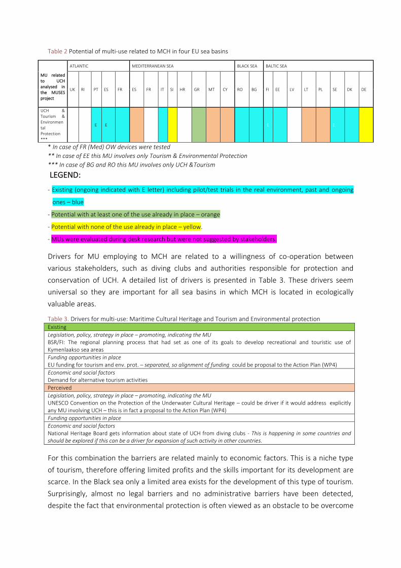
Table 2 Potential of multi-use related to MCH in four EU sea basins
MU related to UCH analysed in the MUSES project
ATLANTIC MEDITERRANEAN SEA BLACK SEA BALTIC SEA
UK RI PT ES FR ES FR IT SI HR GR MT CY RO BG FI EE LV LT PL SE DK DE
UCH & Tourism & Environmental Protection ***
E E E E
* In case of FR (Med) OW devices were tested
** In case of EE this MU involves only Tourism & Environmental Protection
*** In case of BG and RO this MU involves only UCH &Tourism
LEGEND:
- Existing (ongoing indicated with E letter) including pilot/test trials in the real environment, past and ongoing
ones – blue
- Potential with at least one of the use already in place – orange
- Potential with none of the use already in place – yellow.
- MUs were evaluated during desk research but were not suggested by stakeholders.
Drivers for MU employing to MCH are related to a willingness of co-operation between
various stakeholders, such as diving clubs and authorities responsible for protection and
conservation of UCH. A detailed list of drivers is presented in Table 3. These drivers seem
universal so they are important for all sea basins in which MCH is located in ecologically
valuable areas.
Table 3. Drivers for multi-use: Maritime Cultural Heritage and Tourism and Environmental protection Existing
Legislation, policy, strategy in place – promoting, indicating the MU BSR/FI: The regional planning process that had set as one of its goals to develop recreational and touristic use of Kymenlaakso sea areas
Funding opportunities in place EU funding for tourism and env. prot. – separated, so alignment of funding could be proposal to the Action Plan (WP4)
Economic and social factors Demand for alternative tourism activities
Perceived
Legislation, policy, strategy in place – promoting, indicating the MU UNESCO Convention on the Protection of the Underwater Cultural Heritage – could be driver if it would address explicitly any MU involving UCH – this is in fact a proposal to the Action Plan (WP4)
Funding opportunities in place
Economic and social factors National Heritage Board gets information about state of UCH from diving clubs - This is happening in some countries and should be explored if this can be a driver for expansion of such activity in other countries.
For this combination the barriers are related mainly to economic factors. This is a niche type
of tourism, therefore offering limited profits and the skills important for its development are
scarce. In the Black sea only a limited area exists for the development of this type of tourism.
Surprisingly, almost no legal barriers and no administrative barriers have been detected,
despite the fact that environmental protection is often viewed as an obstacle to be overcome
for development. The strong opinions of fishermen also seem to be an important perceived
barrier with regards to those who might have problems on how to organize a new type of
economic business. After overcoming these problems, one can focus on the development of
the drivers for this MU. Another important barrier highlighted in several sea basins refer to
the lack of research informing decision-makers and authorities on the potential benefits
(environmental and socio-economic) of combining these sectors into an MU.
The above barriers seem universal so they are important for all sea basins in which tourism
and fisheries are performed in ecologically valuable areas and there are also some sea basin
specific barriers (Black Sea, Eastern Atlantic, Mediterranean). A detailed list of barriers is
presented in Table 3 below.
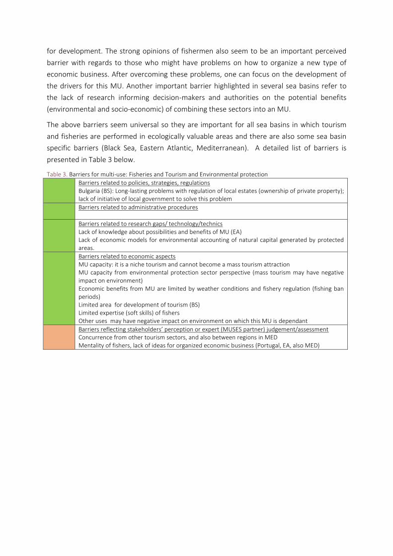
Table 3. Barriers for multi-use: Fisheries and Tourism and Environmental protection
Barriers related to policies, strategies, regulations Bulgaria (BS): Long-lasting problems with regulation of local estates (ownership of private property); lack of initiative of local government to solve this problem
Barriers related to administrative procedures
Barriers related to research gaps/ technology/technics Lack of knowledge about possibilities and benefits of MU (EA) Lack of economic models for environmental accounting of natural capital generated by protected areas.
Barriers related to economic aspects MU capacity: it is a niche tourism and cannot become a mass tourism attraction MU capacity from environmental protection sector perspective (mass tourism may have negative impact on environment) Economic benefits from MU are limited by weather conditions and fishery regulation (fishing ban periods) Limited area for development of tourism (BS) Limited expertise (soft skills) of fishers Other uses may have negative impact on environment on which this MU is dependant
Barriers reflecting stakeholders’ perception or expert (MUSES partner) judgement/assessment Concurrence from other tourism sectors, and also between regions in MED Mentality of fishers, lack of ideas for organized economic business (Portugal, EA, also MED)
3.4. From dots to areas - BalticRIM cultural “hot spots” – Baltic MCH priority areas
MCH is still not ready to be included in MSP in the other form than either general
(precautionary) rules or guidelines or dots with regard to identified MCH. countries just map
the UCH they know that they have. Only Finland and Sweden did some valorisation of their
sea space with regard to UCH. But they made a map showing the number of historical wrecks
per 100km2. This valorisation is based on quantity, not quality of MCH. In addition. only
wrecks without other types of UCH were counted. The main problem is the lack of relevant
information, including missing information on quality of MCH. In each country quality is
assessed in different way and the project showed no clear perspective for a joint BSR
common denominator with this regard. Thus BSR priority areas for MCH cannot be identified
since different countries have different priorities with regard to MCH. The only feasible
solution would be putting on one map all national MCH priority areas when they are
identified in particular country in order to inform their MSP process and also countries
around. However, this should not be interpreted as abandoning an idea of more
comprehensive (area based) approach to UCH in MSP. The MCH relevant zone should be
mapped under national MSP processes but rather for influencing other uses purpose than
reserving space for MCH as a priority function. It seems that within MCH the following zones
can be named:
1. Zones carefully researched in which probably key MCH has been already identified and
mapped by UCH does not play a leading role.
2. Zones carefully researched in which probably key MCH has been already identified and
mapped and MCH can activate multi-use of the sea. (MCH has important economic
potential).
3. Zones, which have not been carefully researched with regard to MCH - but MCH can
appear there not intensively.
4. Zones which have not been carefully researched with regard to MCH but MCH is
expected to appear there (busy ancient trade routes, changes of the coast, battlefields
etc.) Here the focus should be on the UCH that is not so intensively represented in the
BSR, e.g. paleo-remainings.
Those zones should not be used as a decision zones in the MSP but rather they should
prompt different treatment of UCH in the planning process.
Under zone type 1 the planning solutions can be very clear and identification of how UCH
(different its types) should be used or protected against other uses. The uses should be
located in the sea taking into consideration the information on UCH.
Under zone type 2 the uses that can form multi-use combination with UCH should be
examined and if they are feasible then located and encouraged.

Under the zone type 3 MSP can formulate some precautionary general rules protecting UCH
and encouraging mapping UCH before undertaking activities that might harm UCH.
Under the zone type 4 detailed rules should be prescribed with regard to activities that might
harm UCH that has not been identified yet. In the part of the plan that is informative for
potential investors. The UCH potential of a given area should be clearly highlighted.
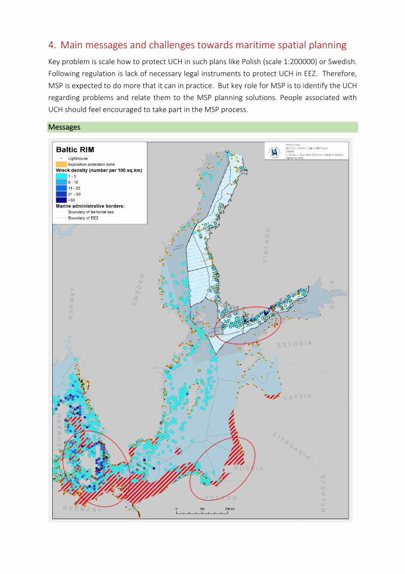
4. Main messages and challenges towards maritime spatial planning
Key problem is scale how to protect UCH in such plans like Polish (scale 1:200000) or Swedish.
Following regulation is lack of necessary legal instruments to protect UCH in EEZ. Therefore,
MSP is expected to do more that it can in practice. But key role for MSP is to identify the UCH
regarding problems and relate them to the MSP planning solutions. People associated with
UCH should feel encouraged to take part in the MSP process.
Messages
• Coastal waters – the ‘kingdom’ of Maritime Cultural Heritage – adequate respect
should be given to those aspects while planning human activities, create planning
security.
• Sandy bottoms of southern Baltic can hide interesting history – ensure proper pre-
investment archaeological surveys.
• Bays and archipelagos – remember to sustain the untouched exposition of maritime
landscape, create the exposition protections zones!
• Joint efforts – cooperate in potential transnational areas of common conditions and
common problems:
CHALLENGES:
• Undiscovered heritage - Lack of knowledge, the marine waters are not sufficiently
surveyed with regards to the archaeological objects – huge problem with white gaps.
• The intensity of wrecks – how to sustain them?
• The MCH and ports developments.
• Transnational cultural areas.
• Transnational cultural routes?
• Underwater museums.
• Need of regional/transnational cooperation? Cross-border archaeological sites
• Awareness-raising among MSP authorities regarding MCH sites.
• Easy accessible and exchangeable data bases of MCH sites for stronger collaboration
between MSP authorities, also related to trans-boundary planning.
• General and automatic consideration of MCH sites in national maritime spatial plans.
• Using knowledge from neighbouring countries for locating MUs.
PLANNING PRINCIPLES
• Definition what is MCH as a key prerequisite for protecting MCH via MSP.
• In situ protection if possible.
• Due to the scale of MCH one should strive towards flexible protection therefore rather
rules than zones for MCH. Zones make sense only in case of large archaeological sites.
But rules should be enforceable. This is a challenge.
• Information matters – Identification not only MCH objects but also potential areas of
their possible existence.
• Preparedness’ i.e. spatial measures necessary since MCH can appear any time and
place and not everywhere it can be protected in situ. So under MSP there is a need for
adequate solutions i.e. how to change planning activities due to sudden discovery of
MCH, how to secure that MCH search precede investment processes or what to do if
MCH cannot be protected in situ (e.g. fairways, port areas).
• Pay attention under MSP to the Multi-Use issue as a potential sector encouraging
multi-use at sea.
• Use scientific knowledge and knowledge from neighbouring countries in order to
detect areas with high probability of the MU appearance (e.g. battle fields or stone-
age settlements.
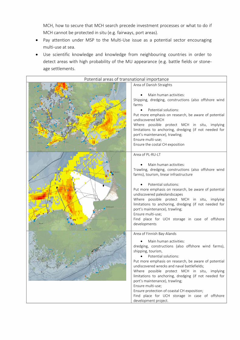
Potential areas of transnational importance
Area of Danish Straights
• Main human activities: Shipping, dredging, constructions (also offshore wind farms
• Potential solutions: Put more emphasis on research, be aware of potential undiscovered MCH Where possible protect MCH in situ, implying limitations to anchoring, dredging (if not needed for port’s maintenance), trawling; Ensure multi-use; Ensure the costal CH exposition
Area of PL-RU-LT
• Main human activities: Trawling, dredging, constructions (also offshore wind farms), tourism, linear infrastructure
• Potential solutions: Put more emphasis on research, be aware of potential undiscovered paleolandscapes Where possible protect MCH in situ, implying limitations to anchoring, dredging (if not needed for port’s maintenance), trawling; Ensure multi-use; Find place for UCH storage in case of offshore developments
Area of Finnish Bay-Alands
• Main human activities: dredging, constructions (also offshore wind farms), shipping, tourism,
• Potential solutions: Put more emphasis on research, be aware of potential undiscovered wrecks and naval battlefields; Where possible protect MCH in situ, implying limitations to anchoring, dredging (if not needed for port’s maintenance), trawling; Ensure multi-use; Ensure protection of coastal CH exposition; Find place for UCH storage in case of offshore development project.
5. Bibliography
Dàmir Belltheus Avdic, Pierre Ståhl, Baltic InteGrid review: towards a meshed offshore grid in the Baltic Sea, Baltic InteGrid, 2019
Eehler, Charles, and Fanny Douvere. Marine Spatial Planning: a step-by-step approach toward ecosystem-based management. Intergovernmental Oceanographic Commission and Man and the Biosphere Programme. IOC Manual and Guides no. 53, iCaM Dossier no. 6. Paris: UNESCO. 2009 (English)
Estonian Maritime Spatial Plan - draft Plan, 2019
Estonian Maritime Spatial Plan, 2019, Draft Plan, pp.59
HELCOMs Second holistic assessment 2011-2016
Latvian Maritime Spatial Plan, 2019
Maritime Spatial Planning —Current Status 2014: National planning in Sweden’s territorial waters and exclusive economic zone (EEZ), Swedish Agency for Marine and Water Management report 2015:16
Matczak Magdalena (red), Analiza Uwarunkowań Zagospodarowania Przestrzennego Polskich Obszarów Morskich, 2019
Matczak Magdalena (red), QUO VADIS Exploring the future of shipping in the Baltic Sea, BalticLINES report, 2018
Nerijus Blažauskas, BaltSeaPlan Report No 15 “Towards a Pilot MSP for the Lithuanian Sea”
Pomian Iwona, Inwentaryzacja morskich stanowisk archeologicznych – wczoraj i dziś, Kurier Konserwatorski,nr 15, 2018
RUTILUS - Strategies for a Sustainable Development of the Underwater Cultural Heritage in the Baltic Sea Region, Swedish National Maritime Museums Report nr 1267/03-51, 2006
Study of Conditions of Spatial Development of Polish Sea Areas, Instytut Morski w Gdańsku, 2016
Suomen Merellisen Kulttuuriperinnön Tilannekuvaus, Museovirasto, Kulttuuriymparistopalvelut –osasto, 2019
Szymon Uścinowicz, Chapter 7 The Baltic Sea continental shelf, in: Continental Shelves of the World: Their Evolution During the Last Glacio-Eustatic Cycle, Geological Society, London, Memoirs, 41, 69-89, 2014
EU MSP Platform (https://www.msp-platform.eu/sea-basins/baltic-sea-0
http://www.nmm.pl/balticlights/Historic&Modern.html
http://www.spp-haefen.de/en/projects/ostseekueste/
https://baltic-heritage.eu/working-groups/underwater-cultural-heritage/rutilus-project-and-100-list/
MUSES project https://muses-project.com/
PartiSEApate project – Multi-level governance in maritime spatial planning throughout the Baltic Sea Region http://www.partiseapate.eu/