Embed Size (px)
Citation preview
145
Global Environmental Research ©2008 AIRIES 12/2008:145-152 printed in Japan
Sustainable Development of Rurality-Based Ecotourism
in Outer Urban Fringe of Tokyo; a Case Study of the Totoro Forest
Toshio KIKUCHI
Tokyo Metropolitan University
1-1 Minami-Ohsawa, Hachiohji, Tokyo 192-0397, Japan e-mail: [email protected]
Abstract This paper focuses on rural land use and its conservation as a reflection of rurality in the outer urban
fringes, and discusses re-creating rurality and utilizing it in conservation and ecotourism activities. In the Sayama Hill district of the Tokyo metropolitan area, rural land use has been restructured and rurality has been recreated through conservation and ecotourism activities in the Totoro Forest. Although rural and urban residents have different perspectives on those activities and their participation in them, their interests in rurality are cooperative in the conservation of rural landscapes. Actually, a relationship between rural and urban residents has been developed through collaborative control and maintenance of the Totoro Forest, which is one of the central establishments for the re-creation of rurality. In the framework of the relationship between rurality and urbanity, mutual relationships among elements of urbanity have been connected with those of rurality through the Totoro Forest as a rural and urban establishment. I conclude that rural residents feel sentimentality for rurality and the religion of rural life as the spirituality of rural spaces in the Totoro Forest, and urban residents feel enjoyment of rural recreation and rurality-based ecotourism as a yearning for green spaces and the natural environment.
Key words: ecotourism, forest, forest conservation, outer fringes, rural land use, rurality
1. Introduction
As with the suburbs of western countries, the urban
fringe of Tokyo is divided into inner and outer fringes by rural and urban land-use patterns (Bryant et al., 1982; Bryant & Johnston, 1992). The inner fringe is characterized by land in the advanced stages of transi-tion from rural to urban uses, dominant location of urban-oriented functions and land subdivision. Particu-larly, the inner fringe of the Tokyo metropolitan area has been characterized by strong conflicts between rural and urban land uses, and rural land use has tended to be drastically reduced since the period of high economic growth in Japan (Kikuchi & Obara, 2004). On the other hand, the outer fringe is characterized by an area where although rural land use dominates the landscape, the infiltration of urban-oriented elements is clear as regards the increase of part-time farms and the development of extensive agriculture (Kikuchi, 2002). In the outer fringe of Tokyo, agricultural land use and forests around it have remained more or less unchanged, and play an important role in the restructuring of rural, residential and recreational spaces. Agricultural land use and for-
ests are fundamental elements of the rural landscape, and are mainly characterized by the functions of agricul-tural and economic activities. With the progression of urbanization, however, the economic function of agri-cultural land use and forests has been reduced in comparison to that of urban land use, and thus farmlands and forests play an important role in re-creating rurality (the atmosphere and cultural traits of the countryside) as multi-functional land use (Kikuchi & Takatori, 1998; Takatori, 2000).
Re-creating rurality, including agricultural land use and forests, has recently become more important as one of the contemporary issues in the urban fringe (Murdoch & Pratt, 1993; Marsden, 1996; Bowler et al., 2002). In this paper I emphasize rurality as an option to urbanity (the atmosphere and cultural traits of a city) in the outer fringe of Tokyo, and discuss ecotourism as a sustainable use of rurality in that area. Following that discussion, I attempt to elucidate a development system that supports rurality-based ecotourism in urban outer fringes. The meanings of rurality are often associated with the character of rural areas, where rural communities occur. In these areas, environmental and economic aspects are
146 T. KIKUCHI
noted expressions of their character and community locations with regard to agricultural activities. Because agricultural activities have declined with the advance of urbanization, rurality has generally waned with the spread of urban land use. In the outer fringe, however, rurality has been re-created by restructuring some basic elements of rural space. Therefore, rurality consists of natural ecological environments, agricultural activities, rural land use of farmlands and forests, and farms and their communities. Interconnections among these ele-ments play an important role in re-creating rurality, re-structuring rural areas and developing recreation spaces (Halfacree, 1995; Liepins, 2000). Particularly, develop-ment of spaces for recreation and ecotourism is worth considering in the restructuring of rural communies and re-creation of outer fringe rurality (Jones, 2005).
2. Changes in Rural Land Use in the Sayama
Hill District
2.1 Distribution of rural land uses in 1974 The Totoro Forest, my case study, lies within the
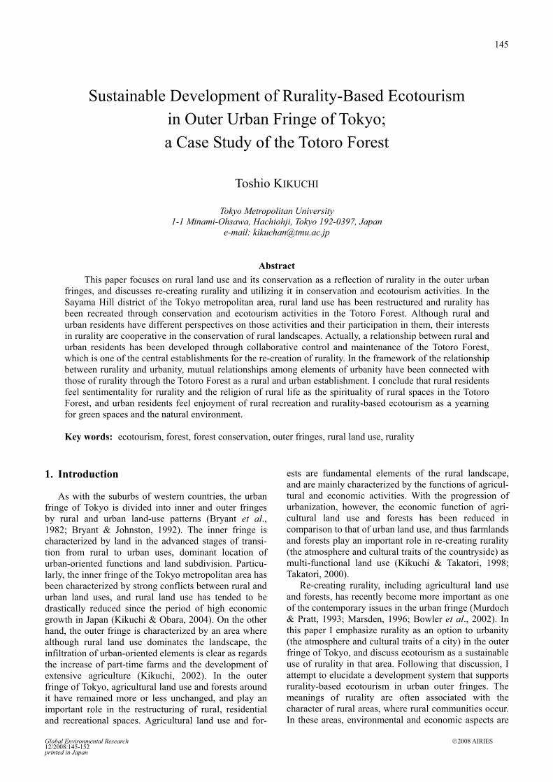
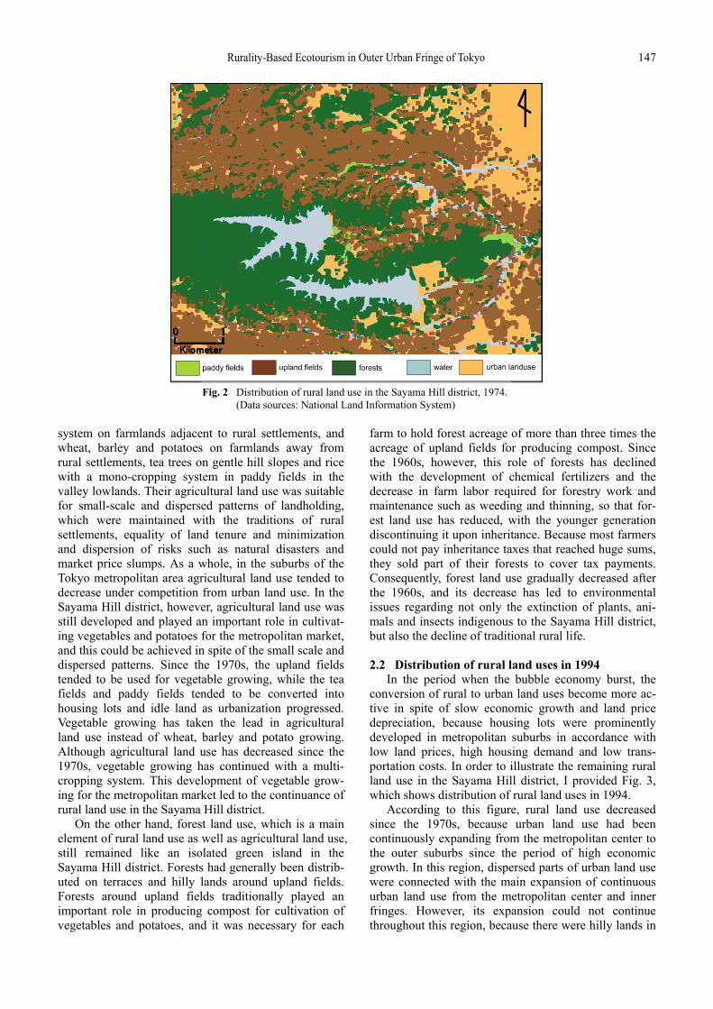
Sayama Hill district, which is situated in the northwest-ern suburbs of Tokyo at a distance of about 30 kilome-ters from the metropolitan center (Fig. 1). In the Sayama Hill district, dispersed urban land use and urban sprawl accelerated the competition for rural land. I prepared the map in Fig. 2 to discuss the distribution of rural land use and its characteristics in the Sayama Hill district in 1974. According to this figure, rural land use remained as an isolated island of green space in spite of the expansion of urban land use, which had continuously spread from the metropolitan center to its outskirts because of in-creasing population. Although the expansion of urban land use has been more remarkable than that of other land use within a 30-kilometer radius of the metro-politan center, urban land was developed in dispersed
small areas disregarding city or regional planning over the radius of the inner fringe. This dispersion not only gave rise to urban sprawl, but also accelerated the expansion of continuous urban land use from the metropolitan center. Overall, urban land use has been developed with regional differences among sectors in the Tokyo metropolitan area. Particularly, in the north-western sectors including the Sayama Hill district, urban land use has expanded beyond the 30 kilometer radius from the metropolitan centre, which was intentionally considered the boundary between built up and rural areas during the period of high economic growth. In the Sayama Hill district, diluvial uplands and gentle hill slopes are distributed widely, and it is easier for those land conditions to come under urban land use. Actually, built up areas were extended through conversion from non-urban into urban land uses on diluvial uplands and gentle hill slopes along certain railroads and main roads. This fact suggests that the conversion of non-urban to urban land uses is supported by the availability of land conditions and accessibility to the metropolitan center.
Regarding the original agricultural land use in the Sayama Hill district, its distribution was characterized by small scale and dispersed patterns, which differed from those in the inner fringe. Upland fields, tea fields and paddy fields were generally distributed on diluvial uplands, gentle hill slopes and valley lowlands, respec-tively. Traditionally, each farm held farmlands of 1.0 to 1.5 hectares, and its farming management mainly com-bined rice, wheat, barley, potato, vegetable and tea cultivation. Each farm held two to four parcels of farm-lands around a rural settlement, on terraces and gentle hill slopes about 300 meters away from the settlement and in valley lowlands. These parcels of farmlands were diversely used according to their distance from the settlement. Generally speaking, vegetables for self- support and sale were grown under a double cropping
Fig. 1 The location of the Totoro Forest in the Tokyo metropolitan area. (Data sources: Chiiki Keikaku Atlas)
Rurality-Based Ecotourism in Outer Urban Fringe of Tokyo 147
system on farmlands adjacent to rural settlements, and wheat, barley and potatoes on farmlands away from rural settlements, tea trees on gentle hill slopes and rice with a mono-cropping system in paddy fields in the valley lowlands. Their agricultural land use was suitable for small-scale and dispersed patterns of landholding, which were maintained with the traditions of rural settlements, equality of land tenure and minimization and dispersion of risks such as natural disasters and market price slumps. As a whole, in the suburbs of the Tokyo metropolitan area agricultural land use tended to decrease under competition from urban land use. In the Sayama Hill district, however, agricultural land use was still developed and played an important role in cultivat-ing vegetables and potatoes for the metropolitan market, and this could be achieved in spite of the small scale and dispersed patterns. Since the 1970s, the upland fields tended to be used for vegetable growing, while the tea fields and paddy fields tended to be converted into housing lots and idle land as urbanization progressed. Vegetable growing has taken the lead in agricultural land use instead of wheat, barley and potato growing. Although agricultural land use has decreased since the 1970s, vegetable growing has continued with a multi- cropping system. This development of vegetable grow-ing for the metropolitan market led to the continuance of rural land use in the Sayama Hill district.
On the other hand, forest land use, which is a main element of rural land use as well as agricultural land use, still remained like an isolated green island in the Sayama Hill district. Forests had generally been distrib-uted on terraces and hilly lands around upland fields. Forests around upland fields traditionally played an important role in producing compost for cultivation of vegetables and potatoes, and it was necessary for each
farm to hold forest acreage of more than three times the acreage of upland fields for producing compost. Since the 1960s, however, this role of forests has declined with the development of chemical fertilizers and the decrease in farm labor required for forestry work and maintenance such as weeding and thinning, so that for-est land use has reduced, with the younger generation discontinuing it upon inheritance. Because most farmers could not pay inheritance taxes that reached huge sums, they sold part of their forests to cover tax payments. Consequently, forest land use gradually decreased after the 1960s, and its decrease has led to environmental issues regarding not only the extinction of plants, ani-mals and insects indigenous to the Sayama Hill district, but also the decline of traditional rural life.
2.2 Distribution of rural land uses in 1994
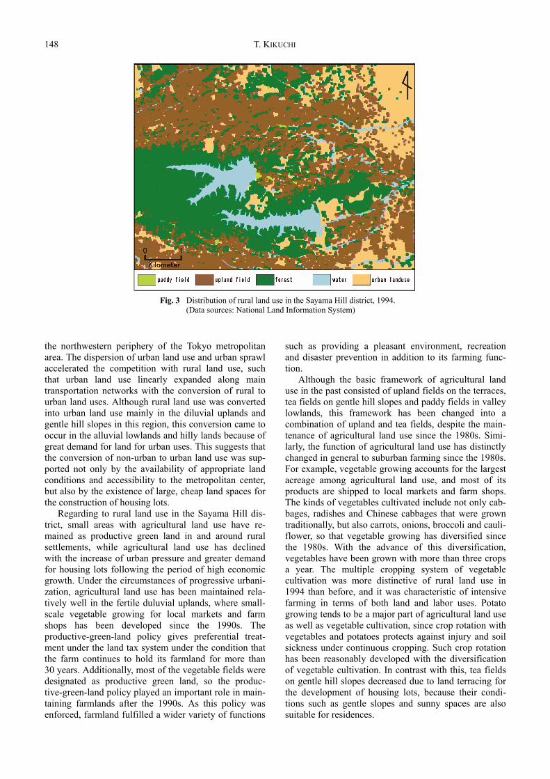
In the period when the bubble economy burst, the conversion of rural to urban land uses become more ac-tive in spite of slow economic growth and land price depreciation, because housing lots were prominently developed in metropolitan suburbs in accordance with low land prices, high housing demand and low trans-portation costs. In order to illustrate the remaining rural land use in the Sayama Hill district, I provided Fig. 3, which shows distribution of rural land uses in 1994.
According to this figure, rural land use decreased since the 1970s, because urban land use had been continuously expanding from the metropolitan center to the outer suburbs since the period of high economic growth. In this region, dispersed parts of urban land use were connected with the main expansion of continuous urban land use from the metropolitan center and inner fringes. However, its expansion could not continue throughout this region, because there were hilly lands in
Fig. 2 Distribution of rural land use in the Sayama Hill district, 1974. (Data sources: National Land Information System)
148 T. KIKUCHI
the northwestern periphery of the Tokyo metropolitan area. The dispersion of urban land use and urban sprawl accelerated the competition with rural land use, such that urban land use linearly expanded along main transportation networks with the conversion of rural to urban land uses. Although rural land use was converted into urban land use mainly in the diluvial uplands and gentle hill slopes in this region, this conversion came to occur in the alluvial lowlands and hilly lands because of great demand for land for urban uses. This suggests that the conversion of non-urban to urban land use was sup-ported not only by the availability of appropriate land conditions and accessibility to the metropolitan center, but also by the existence of large, cheap land spaces for the construction of housing lots.
Regarding to rural land use in the Sayama Hill dis-trict, small areas with agricultural land use have re-mained as productive green land in and around rural settlements, while agricultural land use has declined with the increase of urban pressure and greater demand for housing lots following the period of high economic growth. Under the circumstances of progressive urbani-zation, agricultural land use has been maintained rela-tively well in the fertile duluvial uplands, where small- scale vegetable growing for local markets and farm shops has been developed since the 1990s. The productive-green-land policy gives preferential treat-ment under the land tax system under the condition that the farm continues to hold its farmland for more than 30 years. Additionally, most of the vegetable fields were designated as productive green land, so the produc-tive-green-land policy played an important role in main-taining farmlands after the 1990s. As this policy was enforced, farmland fulfilled a wider variety of functions
such as providing a pleasant environment, recreation and disaster prevention in addition to its farming func-tion.
Although the basic framework of agricultural land use in the past consisted of upland fields on the terraces, tea fields on gentle hill slopes and paddy fields in valley lowlands, this framework has been changed into a combination of upland and tea fields, despite the main-tenance of agricultural land use since the 1980s. Simi-larly, the function of agricultural land use has distinctly changed in general to suburban farming since the 1980s. For example, vegetable growing accounts for the largest acreage among agricultural land use, and most of its products are shipped to local markets and farm shops. The kinds of vegetables cultivated include not only cab-bages, radishes and Chinese cabbages that were grown traditionally, but also carrots, onions, broccoli and cauli-flower, so that vegetable growing has diversified since the 1980s. With the advance of this diversification, vegetables have been grown with more than three crops a year. The multiple cropping system of vegetable cultivation was more distinctive of rural land use in 1994 than before, and it was characteristic of intensive farming in terms of both land and labor uses. Potato growing tends to be a major part of agricultural land use as well as vegetable cultivation, since crop rotation with vegetables and potatoes protects against injury and soil sickness under continuous cropping. Such crop rotation has been reasonably developed with the diversification of vegetable cultivation. In contrast with this, tea fields on gentle hill slopes decreased due to land terracing for the development of housing lots, because their condi-tions such as gentle slopes and sunny spaces are also suitable for residences.
Fig. 3 Distribution of rural land use in the Sayama Hill district, 1994. (Data sources: National Land Information System)
Rurality-Based Ecotourism in Outer Urban Fringe of Tokyo 149
On the other hand, forest land use has been main-tained as an insular pattern of green space in spite of its availability for the development of housing lots. How-ever, forest land use around rural settlements and near railroad stations has rapidly decreased with the develop-ment of housing lots from the 1970s to the 1980s. Because the economic function of forests decreased with the decline of forestry and forest resource utiliza-tion, and because forests were not served with preferen-tial treatment under the land tax system, unlike produc-tive green land, farmers tended to sell parts of their forests to pay taxes and get much money from the 1970s to the 1980s. Since the 1990s, farmers and urban residents in the Sayama Hill district have recognized that forests have played an important role in maintaining the high quality of the natural environment such as green and ecotourism spaces, a pleasant atmosphere, quiet and spirituality, so forests have been maintained by conservation groups organized by farmers and urban residents. According to these activities, most of the forests have been designated valuable green and eco-tourism spaces. Actually, forest land use generally remains on the terraced and hilly lands around rural settlements, where the meaning of forests has changed from groves of local deities to the symbol of a fine residential and recreational environment. In the Sayama Hill district, the Totoro Forest is one of the forests that are maintained by conservation groups, whose activities contribute to land use of the remaining forest as a space for ecotourism.
3. Conservation and Ecotourism Activities in
the Totoro Forest The Totoro Forest was named after the title character
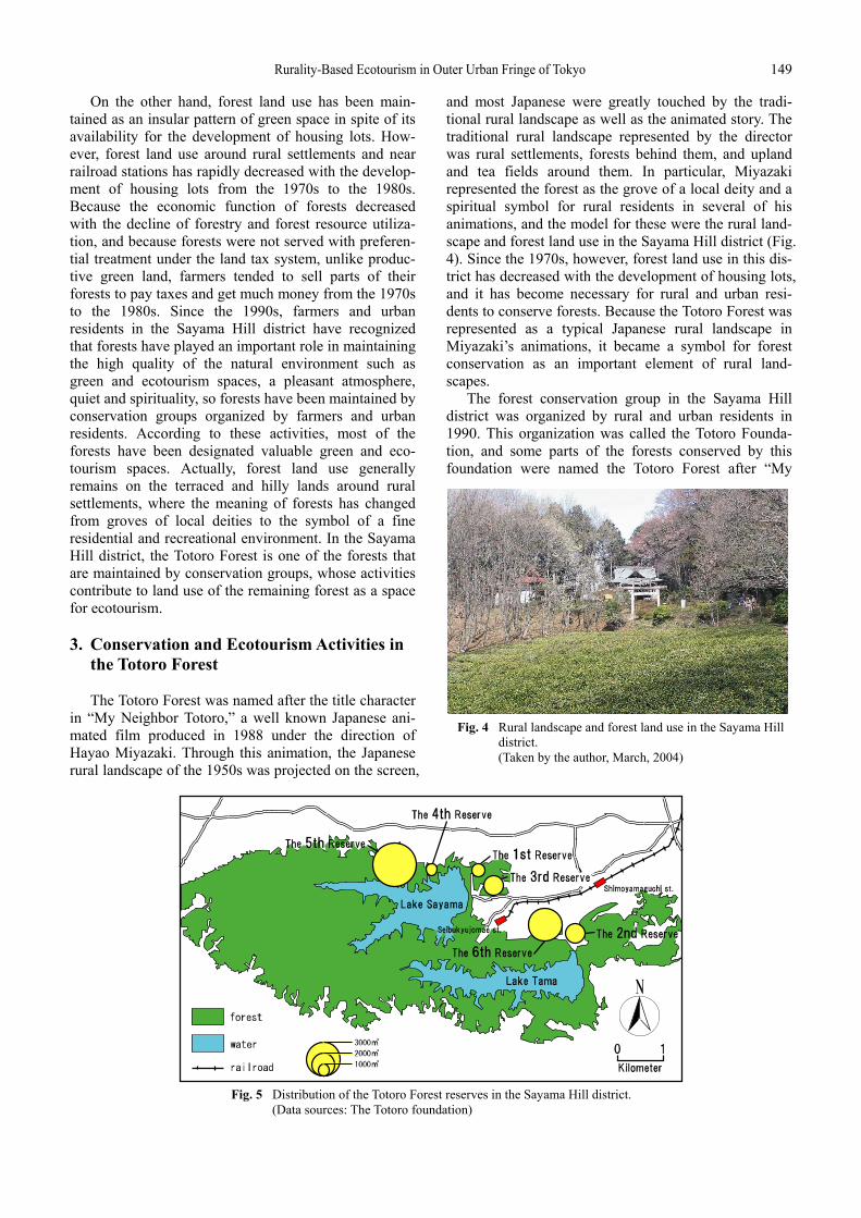
in “My Neighbor Totoro,” a well known Japanese ani-mated film produced in 1988 under the direction of Hayao Miyazaki. Through this animation, the Japanese rural landscape of the 1950s was projected on the screen,
and most Japanese were greatly touched by the tradi-tional rural landscape as well as the animated story. The traditional rural landscape represented by the director was rural settlements, forests behind them, and upland and tea fields around them. In particular, Miyazaki represented the forest as the grove of a local deity and a spiritual symbol for rural residents in several of his animations, and the model for these were the rural land-scape and forest land use in the Sayama Hill district (Fig. 4). Since the 1970s, however, forest land use in this dis-trict has decreased with the development of housing lots, and it has become necessary for rural and urban resi-dents to conserve forests. Because the Totoro Forest was represented as a typical Japanese rural landscape in Miyazaki’s animations, it became a symbol for forest conservation as an important element of rural land-scapes.
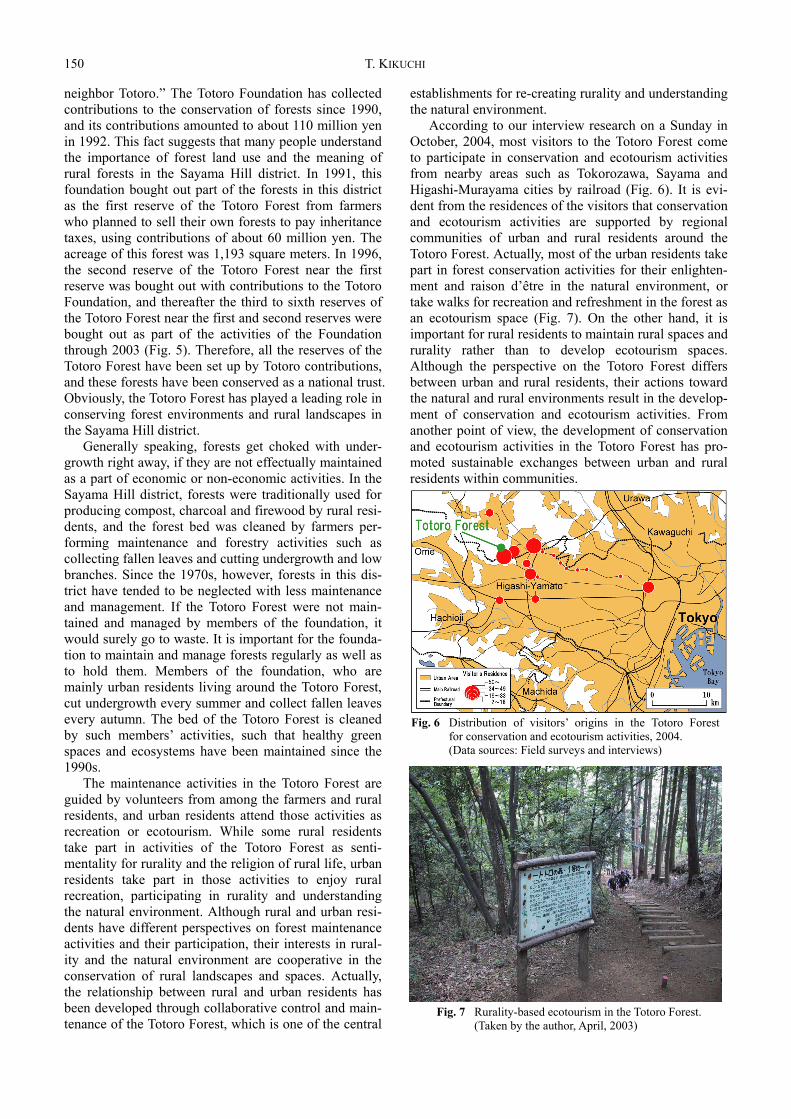
The forest conservation group in the Sayama Hill district was organized by rural and urban residents in 1990. This organization was called the Totoro Founda-tion, and some parts of the forests conserved by this foundation were named the Totoro Forest after “My
Fig. 5 Distribution of the Totoro Forest reserves in the Sayama Hill district. (Data sources: The Totoro foundation)
Fig. 4 Rural landscape and forest land use in the Sayama Hill district.
(Taken by the author, March, 2004)
150 T. KIKUCHI
neighbor Totoro.” The Totoro Foundation has collected contributions to the conservation of forests since 1990, and its contributions amounted to about 110 million yen in 1992. This fact suggests that many people understand the importance of forest land use and the meaning of rural forests in the Sayama Hill district. In 1991, this foundation bought out part of the forests in this district as the first reserve of the Totoro Forest from farmers who planned to sell their own forests to pay inheritance taxes, using contributions of about 60 million yen. The acreage of this forest was 1,193 square meters. In 1996, the second reserve of the Totoro Forest near the first reserve was bought out with contributions to the Totoro Foundation, and thereafter the third to sixth reserves of the Totoro Forest near the first and second reserves were bought out as part of the activities of the Foundation through 2003 (Fig. 5). Therefore, all the reserves of the Totoro Forest have been set up by Totoro contributions, and these forests have been conserved as a national trust. Obviously, the Totoro Forest has played a leading role in conserving forest environments and rural landscapes in the Sayama Hill district.
Generally speaking, forests get choked with under-growth right away, if they are not effectually maintained as a part of economic or non-economic activities. In the Sayama Hill district, forests were traditionally used for producing compost, charcoal and firewood by rural resi-dents, and the forest bed was cleaned by farmers per-forming maintenance and forestry activities such as collecting fallen leaves and cutting undergrowth and low branches. Since the 1970s, however, forests in this dis-trict have tended to be neglected with less maintenance and management. If the Totoro Forest were not main-tained and managed by members of the foundation, it would surely go to waste. It is important for the founda-tion to maintain and manage forests regularly as well as to hold them. Members of the foundation, who are mainly urban residents living around the Totoro Forest, cut undergrowth every summer and collect fallen leaves every autumn. The bed of the Totoro Forest is cleaned by such members’ activities, such that healthy green spaces and ecosystems have been maintained since the 1990s.
The maintenance activities in the Totoro Forest are guided by volunteers from among the farmers and rural residents, and urban residents attend those activities as recreation or ecotourism. While some rural residents take part in activities of the Totoro Forest as senti-mentality for rurality and the religion of rural life, urban residents take part in those activities to enjoy rural recreation, participating in rurality and understanding the natural environment. Although rural and urban resi-dents have different perspectives on forest maintenance activities and their participation, their interests in rural-ity and the natural environment are cooperative in the conservation of rural landscapes and spaces. Actually, the relationship between rural and urban residents has been developed through collaborative control and main-tenance of the Totoro Forest, which is one of the central
establishments for re-creating rurality and understanding the natural environment.
According to our interview research on a Sunday in October, 2004, most visitors to the Totoro Forest come to participate in conservation and ecotourism activities from nearby areas such as Tokorozawa, Sayama and Higashi-Murayama cities by railroad (Fig. 6). It is evi-dent from the residences of the visitors that conservation and ecotourism activities are supported by regional communities of urban and rural residents around the Totoro Forest. Actually, most of the urban residents take part in forest conservation activities for their enlighten-ment and raison d’être in the natural environment, or take walks for recreation and refreshment in the forest as an ecotourism space (Fig. 7). On the other hand, it is important for rural residents to maintain rural spaces and rurality rather than to develop ecotourism spaces. Although the perspective on the Totoro Forest differs between urban and rural residents, their actions toward the natural and rural environments result in the develop-ment of conservation and ecotourism activities. From another point of view, the development of conservation and ecotourism activities in the Totoro Forest has pro-moted sustainable exchanges between urban and rural residents within communities.
Fig. 6 Distribution of visitors’ origins in the Totoro Forest for conservation and ecotourism activities, 2004.
(Data sources: Field surveys and interviews)
Fig. 7 Rurality-based ecotourism in the Totoro Forest. (Taken by the author, April, 2003)
Rurality-Based Ecotourism in Outer Urban Fringe of Tokyo 151
4. Sustainable Development of Ecotourism Based on Re-creating Rurality: In Conclusion The decrease in farmlands, forests and farms has led
to a decline in rural land use in this district, because of serious conflicts between rural and urban land uses under the environment of outer fringes, and because many urban residents live in areas undergoing promo-tion of urbanization as newcomers. Urban and rural resi-dents have been intermixed in rural settlements, and traditional rurality has been lost with the increase of urban residents and decrease in rural land use. The tradi-tional rurality consisted of farms, their communities, their ecological bases such as farmlands and forests, economic activities such as farming and forestry, and some kinds of rural establishments supporting their eco-nomic and social activities. This rurality was developed with an interrelationship among these elements. Although it was developed with exclusive and strong relationships among farmers, it was disrupted by the influx of urban residents, and the rural landscape was damaged, with the loss of ecological and socio- economic bases such as farmlands and forests, farming labor and some kinds of rural establishments.
Instead of traditional rurality, urbanity has become the dominant part of the regional atmosphere in the Sayama Hill district. It is usual that urbanity consists of urban residents and their communities, urban land use, urban economic activities, and some kinds of the urban establishments supporting their urban life. This urbanity is developed with the increase of urban residents, who commute to the Tokyo metropolitan center and live in this district as a so-called “bed town,” with no sense of it being their “own home” (furusato). Following the development of urbanity, urban land use took the place of rural land use in a major way, and was not compatible with it. Because communities, land use, economic activities and establishments in terms of urbanity are alternative elements as options of rurality in the outer fringes, the dominance of these elements has led to a weakening of rurality in the Sayama Hill district. Gener-ally speaking, rurality and urbanity are contrary to each other, and it is difficult for rurality to coexist with urbanity in the outer fringes.
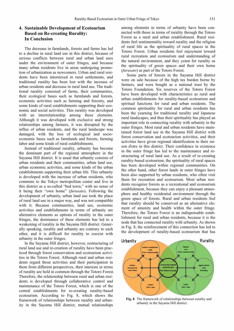
In the Sayama Hill district, however, restructuring of rural land use and re-creation of rurality have been prac-ticed through forest conservation and ecotourism activi-ties in the Totoro Forest. Although rural and urban resi-dents regard those activities and their participation in them from different perspectives, their interests in terms of rurality are held in common through the Totoro Forest. Therefore, the relationship between rural and urban resi-dents is developed through collaborative control and maintenance of the Totoro Forest, which is one of the central establishments for re-creating rurality-based ecotourism. According to Fig. 8, which shows the framework of relationships between rurality and urban-ity in the Sayama Hill district, mutual relationships
among elements in terms of urbanity have been con-nected with those in terms of rurality through the Totoro Forest as a rural and urban establishment. Rural resi-dents feel sentimentality toward rurality and the religion of rural life as the spirituality of rural spaces in the Totoro Forest. Urban residents feel enjoyment toward rural recreation and ecotourism and understanding of the natural environment, and they yearn for rurality as the spirituality of green spaces and their own home (furusato) as part of the Totoro Forest.
Some parts of forests in the Sayama Hill district were on sale because of the high tax burden borne by farmers, and were bought as a national trust by the Totoro Foundation. Six reserves of the Totoro Forest have been developed with characteristics as rural and urban establishments for rurality-based ecotourism and spiritual functions for rural and urban residents. The common spirituality for rural and urban residents has been the yearning for traditional rurality and Japanese rural landscapes, and thus their spirituality has played an important role in connecting rurality with urbanity in the outer fringes. Most rural and urban residents have main-tained forest land use in the Sayama Hill district with forest conservation and ecotourism activities, and their activities have given regional identification to their rai-son d'etre in this district. Their confidence in existence in the outer fringe has led to the maintenance and re-structuring of rural land use. As a result of re-creating ruraltiy-based ecotourism, the spirituality of rural spaces has been developed within regional communities. On the other hand, other forest lands in outer fringes have been also supported by urban residents, who often visit them for recreation and ecotourism. Most urban resi-dents recognize forests as a recreational and ecotourism establishment, because they can enjoy a pleasant atmos-phere and healthy residential environment through the green space of forests. Rural and urban residents feel that rurality should be conserved as an alternative ele-ment of amenity and health within the outer fringe. Therefore, the Totoro Forest is an indispensable estab-lishment for rural and urban residents, because it is the node that has connected rurality with urbanity. As shown in Fig. 8, the reinforcement of this connection has led to the development of rurality-based ecotourism that has
Fig. 8 The framework of relationships between rurality and urbanity in the Sayama Hill district.
152 T. KIKUCHI
nested the characteristics of urban and rural communi-ties comprehensively.
References Bowler, I. R., C. R. Bryant and C. Cocklin (2002) The Sustain-
ability of Rural Systems. Kluwer Academic Publishers, London. Bryant, C. R., L. H. Russwurm and A. G. McLellan (1982) The
City’s Countryside, Land and Its Management in the Rural-Urban Fringe. Longman, London.
Bryant, C. R. and T. R. R. Johnston (1992) Agriculture in the city’s countryside. Belhaven Press, London.
Halfacree, K. (1995) Talking about rurality: social representation of the rural as expressed by residents of six English parishes. Journal of Rural Studies, 11: 1-20.
Jones, S. (2005) Community based ecotourism: the significance of social capital. Annals of Tourism Research, 31:303-324.
Kikuchi, T. (2002) Agricultural land use changes and their sustainability in the urban shadow of the Sydney metropolitan region, Australia: A Case Study of Castlereagh Area, Penrith City. Journal of Geography, 111: 81-99. (in Japanese with English abstract)
Kikuchi, T. and Y. Takatori (1998) Sustainability of agricultural land use changes in urban fringe, a case study of Chofu city, Tokyo metropolis. Geographical Reports of Tokyo Metropolitan University, 33: 45-62.
Kikuchi, T. and N. Obara (2004) Spatio-temporal changes of urban fringe in Tokyo metropolitan area. Geographical Reports of Tokyo Metropolitan University, 39: 57-69.
Liepins, R. (2000) Exploring rurality through ‘community’: dis-courses, practices and spaces shaping Australia and New Zealand rural ‘communities.’ Journal of Rural Studies, 16: 325-341.
Marsden, T. (1996) Rural geography trend report: the social and political bases of rural restructuring. Progress in Human
Geography, 20: 246-258. Murdoch, T. and A. Pratt (1993) Rural studies: modernism, post-
modernism and the “post rural.” Journal of Rural Studies, 9: 411-428.
Takatori, Y. (2000) The multi-functional system urban agriculture in the suburbs of Tokyo: a case study in the Nishi-Ooizumi area of Nerima word, Tokyo. Journal of Geography, 109: 401-417. (in Japanese with English abstract)
Toshio KIKUCHI
Toshio KIKUCHI is a Professor ofGeography and Tourism Science at theGraduate School of Urban EnvironmentalSciences, Tokyo Metropolitan University.He has been the organizer of theDepartment of Tourism Sciences at TokyoMetropolitan University since 2005. Hehas served as the Chief Editor of theGeographical Review of Japan for the
Association of Japanese Geographers since 2008. He is a member of the Tourism Council and Eco-Top (Ecological Conservation Training of Personal Program) Committee in the Tokyo Metropolitan Government. He specializes in agricultural and rural geography, while his academic interests cover wide phenomena such as rural tourism, sustainable rural systems, rural restructuring, land use/cover changes, ecotourism, the relationship between nature and human environments and other related topics. He has published many books, including “Regional Conditions for Sustainable Rural Systems” (Nourin-Tokei-Kyoukai Pub. Co., Tokyo), “Natural Environment and Culture” (Harashobo Pub. Co., Tokyo), “Studies on Forests”(Ninomiya-shoten Pub. Co., Tokyo) and “Introduction to Tourism: Learning with Pleasure” (Ninomiya-shoten Pub. Co., Tokyo).
(Received 27 June 2008, Accepted 10 November 2008)