Embed Size (px)
Citation preview
The North-Betic Strait
José M. Martín, Juan C. Braga, Julio Aguirre & Ángel Puga-Bernabéu
Departamento de Estratigrafía y PaleontologíaUniversidad de Granada
Significance
- The North-Betic Strait was considered for a long time as the main way of communication between the Atlantic Ocean and the Mediterranean Sea during the Miocene (see Hsü et al.,1973,1977).
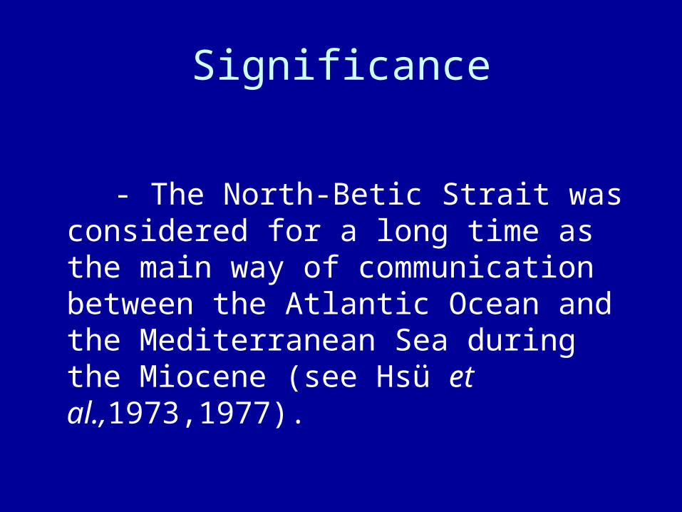
Precise location and age Nevertheless, its precise location and age were unknown. It was thought to have
been located somewhere in the Prebetic Zone (outermost part of the Betic Cordillera) and to have been differentiated as such sometime during the Miocene.
How to recognize ancient straits?
- Huge, cross-bedded structures are characteristic features in the sedimentary record of ancient straits.
- Two representative examples of ancient straits are found in the Betic Cordillera: the “Dehesas de Guadix” and the “Guadalhorce” Straits. In both cases bottom currents flowing from the Mediterranean Sea to the Atlantic Ocean moved giant dunes on the sea floor generating large-scale (giant) cross bedding.
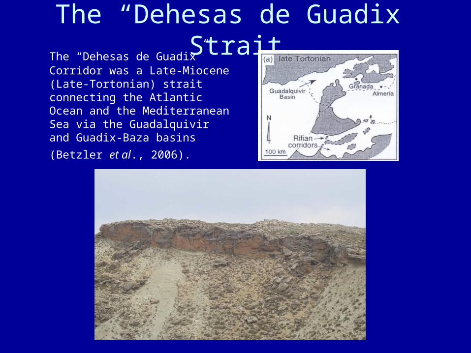
The “Dehesas de Guadix” Strait The “Dehesas de Guadix” Corridor
was a Late-Miocene (Late-Tortonian) strait connecting the Atlantic Ocean and the Mediterranean Sea via the Guadalquivir and Guadix-Baza
basins (Betzler et al., 2006).
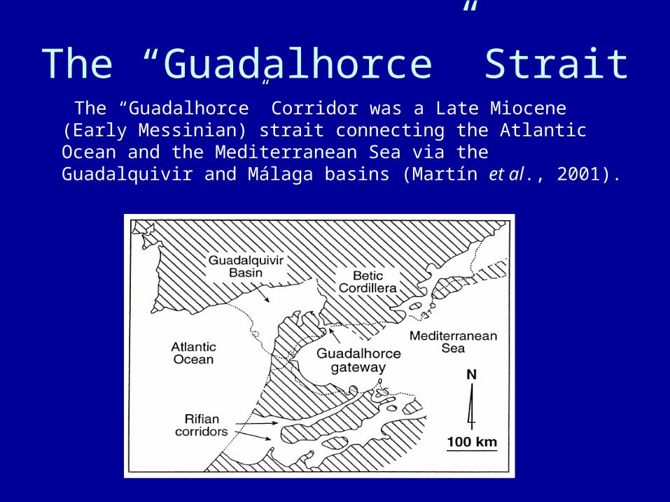
The “Guadalhorce” Strait The “Guadalhorce” Corridor was a Late Miocene (Early
Messinian) strait connecting the Atlantic Ocean and the Mediterranean Sea via the Guadalquivir and Málaga basins (Martín et al., 2001).
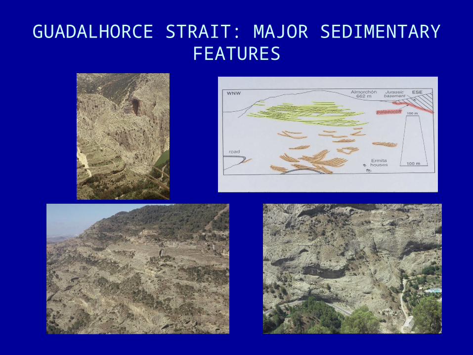
GUADALHORCE STRAIT: MAJOR SEDIMENTARY FEATURES
The Miocene record of the western Prebetic
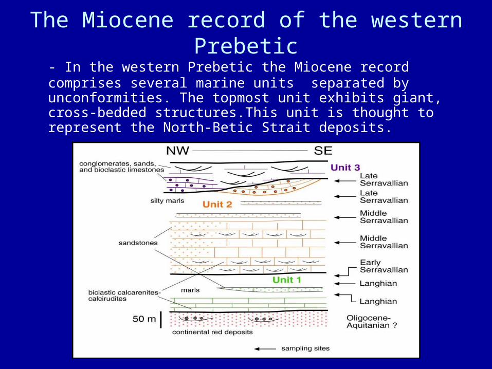
- In the western Prebetic the Miocene record comprises several marine units separated by unconformities. The topmost unit exhibits giant, cross-bedded structures.This unit is thought to represent the North-Betic Strait deposits.
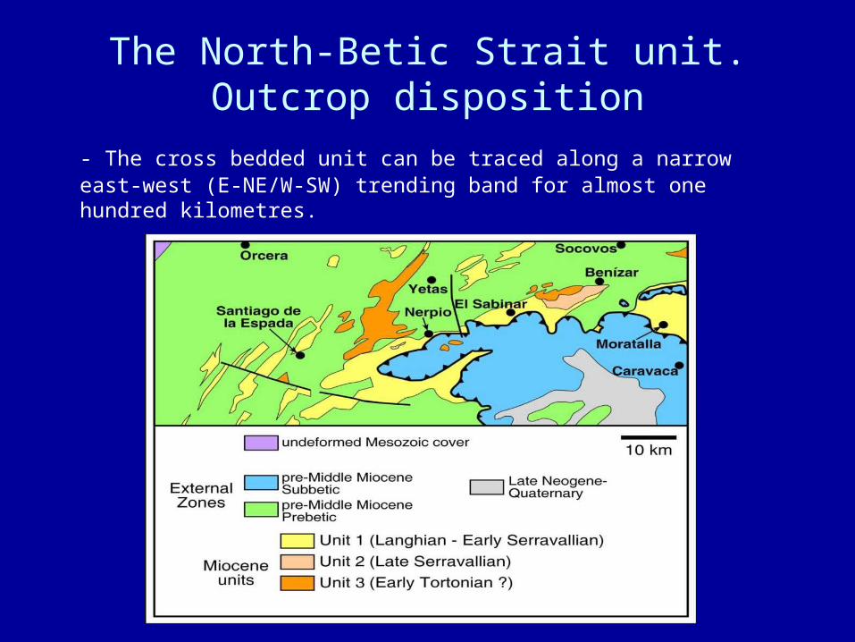
The North-Betic Strait unit.Outcrop disposition
- The cross bedded unit can be traced along a narrow east-west (E-NE/W-SW) trending band for almost one hundred kilometres.
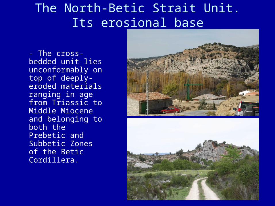
The North-Betic Strait Unit.Its erosional base
- The cross-bedded unit lies unconformably on top of deeply-eroded materials ranging in age from Triassic to Middle Miocene and belonging to both the Prebetic and Subbetic Zones of the Betic Cordillera.
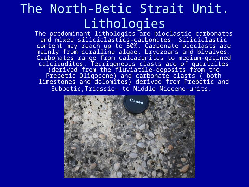
The North-Betic Strait Unit.Lithologies
The predominant lithologies are bioclastic carbonates and mixed siliciclastics-carbonates. Siliciclastic content may reach up to
30%. Carbonate bioclasts are mainly from coralline algae, bryozoans and bivalves. Carbonates range from calcarenites to
medium-grained calcirudites. Terrigeneous clasts are of quartzites (derived from the fluviatile-deposits from the Prebetic
Oligocene) and carbonate clasts ( both limestones and dolomites) derived from Prebetic and Subbetic,Triassic- to
Middle Miocene-units.
Lithologies (II)
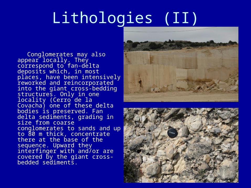
Conglomerates may also appear locally. They correspond to fan-delta deposits which, in most places, have been intensively reworked and reincorporated into the giant cross-bedding structures. Only in one locality (Cerro de la Covacha) one of these delta bodies is preserved. Fan delta sediments, grading in size from coarse conglomerates to sands and up to 80 m thick, concentrate there at the base of the sequence. Upward they interfinger with and/or are covered by the giant cross-bedded sediments.
Selected sections
For the detailed study of the North-Betic Strait unit four sections (Los Olmos, El Bajil, Nerpio and Cortijos Nuevos sections) have been selected along a northeast-southwest transect. Further observations refer to the westernmost outcrops (Santiago de la Espada area).
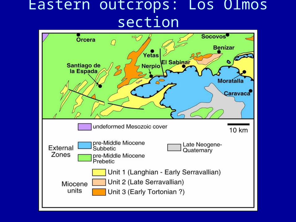
Eastern outcrops: Los Olmos section
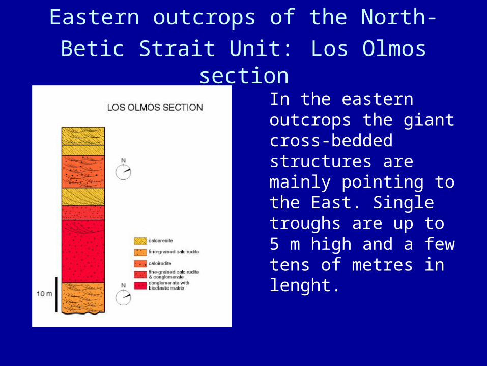
Eastern outcrops of the North-Betic Strait
Unit: Los Olmos section
In the eastern outcrops the giant cross-bedded structures are mainly pointing to the East. Single troughs are up to 5 m high and a few tens of metres in lenght.
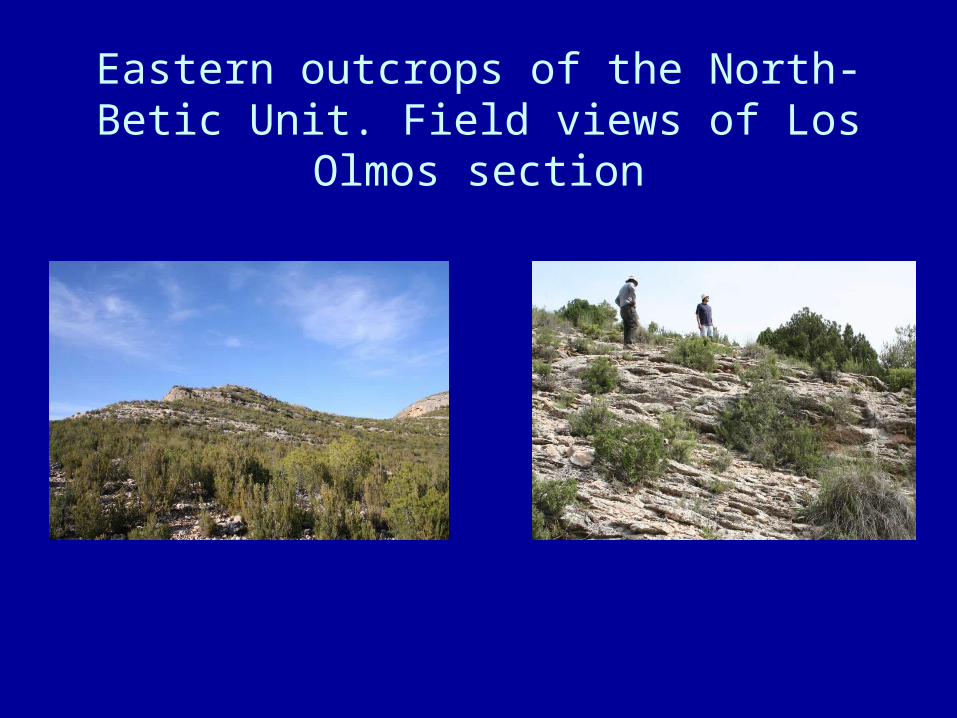
Eastern outcrops of the North-Betic Unit. Field views of Los Olmos section
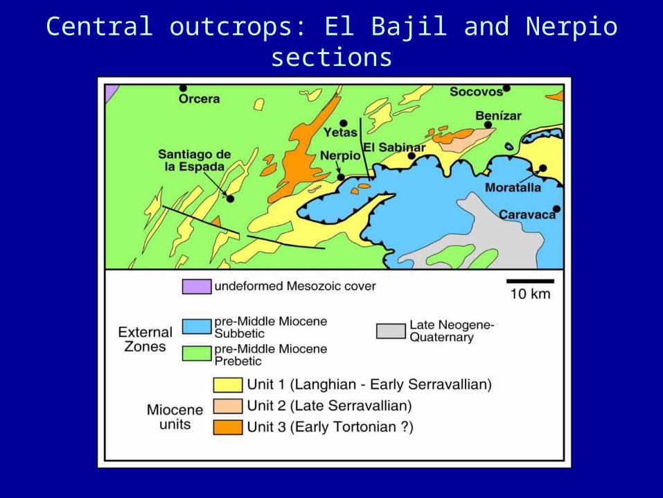
Central outcrops: El Bajil and Nerpio sections
The North-Betic Unit.The central outcrops
In the central outcrops the giant cross-bedded structures point both to
the East and to the West. Single troughs are up to 15 m high and some tens of metres in lenght.
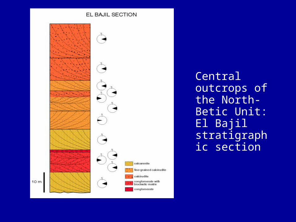
Central outcrops of the North-Betic Unit: El Bajil stratigraphic section
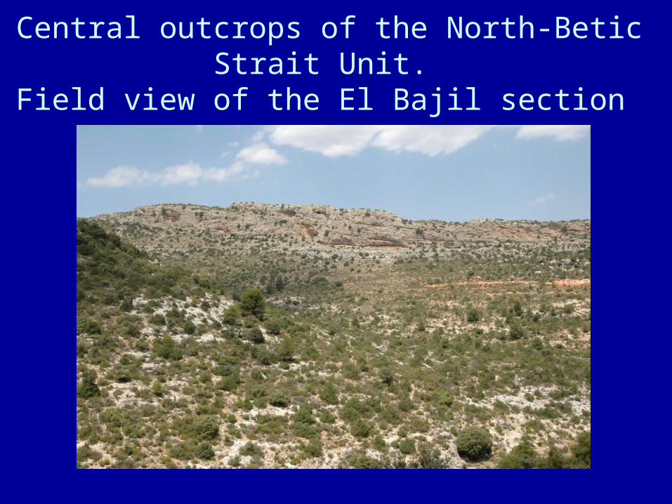
Central outcrops of the North-Betic Strait Unit. Field view of the El Bajil section
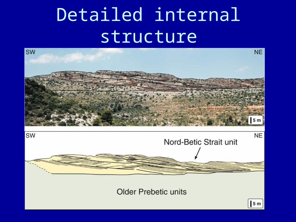
Detailed internal structure
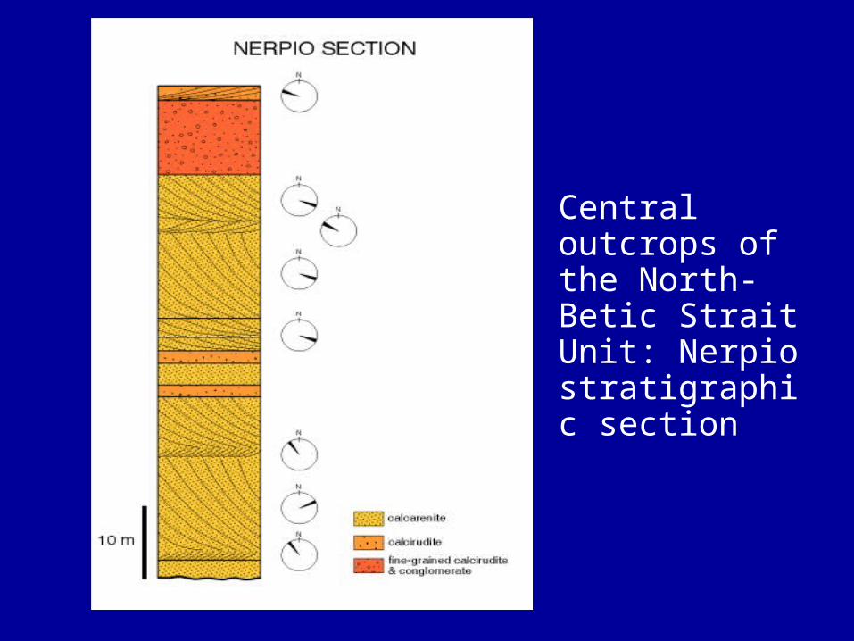
Central outcrops of the North-Betic Strait Unit: Nerpio stratigraphic section
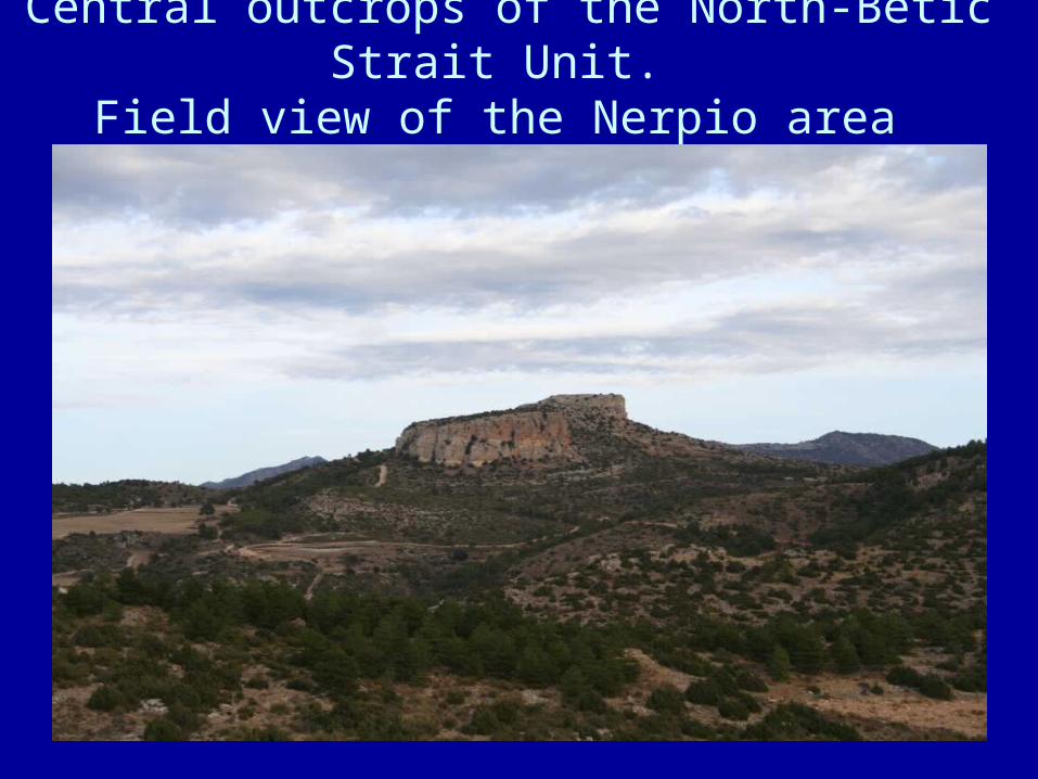
Central outcrops of the North-Betic Strait Unit. Field view of the Nerpio area
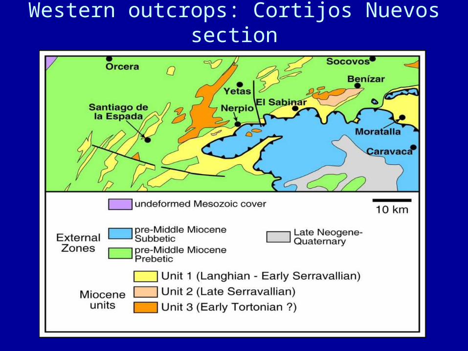
Western outcrops: Cortijos Nuevos section
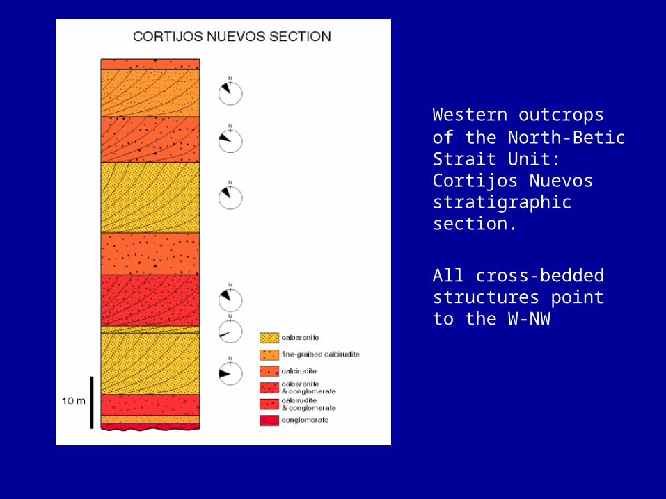
Western outcrops of the North-Betic Strait Unit: Cortijos Nuevos stratigraphic section.
All cross-bedded structures point to the W-NW
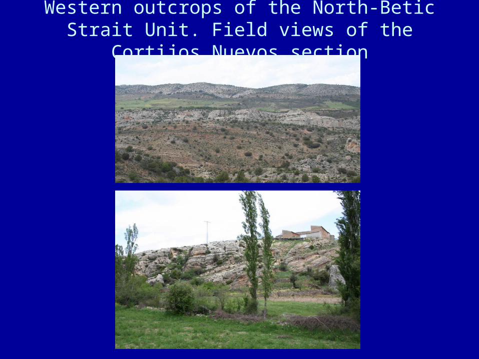
Western outcrops of the North-Betic Strait Unit. Field views of the Cortijos Nuevos section
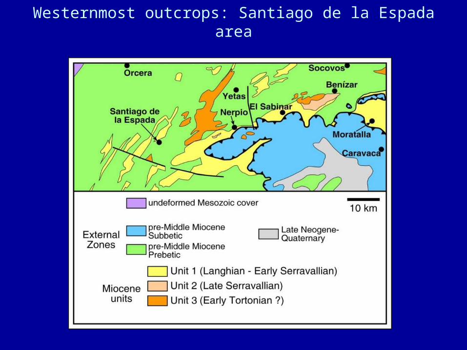
Westernmost outcrops: Santiago de la Espada area
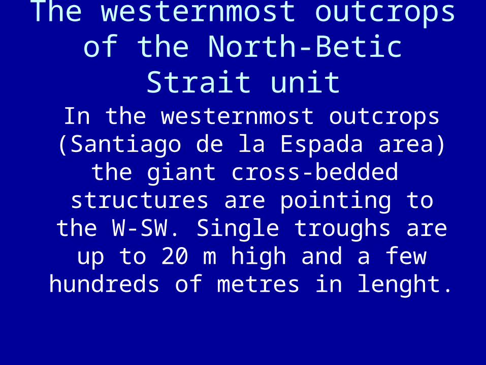
The westernmost outcrops of the North-Betic Strait unit
In the westernmost outcrops (Santiago de la Espada area) the giant cross-bedded structures are
pointing to the W-SW. Single troughs are up to 20 m high and a few hundreds of metres in lenght.
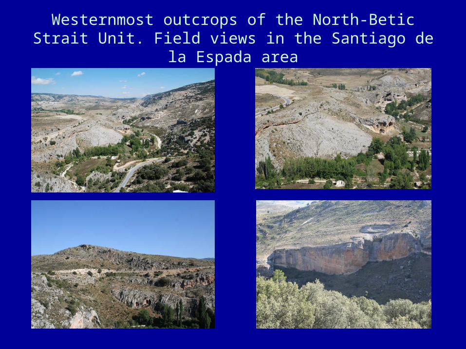
Westernmost outcrops of the North-Betic Strait Unit. Field views in the Santiago de la Espada area

Genesis of the giant cross-bedding
- The giant cross-bedding observed in the North-Betic Strait deposits is thought to be linked to the migration of large-scale dunes moved by tides. Similar structures in size and composition have been described in Present-day tide-dominated channels (Berné, 1991).- The existence of composite structures with reverse cross-bedding direction and abundant reactivation surfaces are strong arguments in favour of tide action.
- For the formation of tidal dunes, comparable in size and with similar grain-sizes, current velocities of up to 1.5 m/s have been reported from some Present-day environments (Harris, 1989; Berné, 1991, ZhenXia et al., 1998).
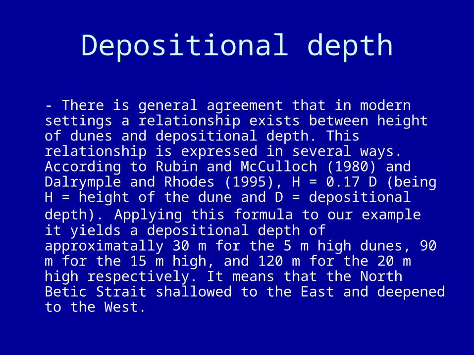
Depositional depth
- There is general agreement that in modern settings a relationship exists between height of dunes and depositional depth. This relationship is expressed in several ways. According to Rubin and McCulloch (1980) and Dalrymple and Rhodes (1995), H = 0.17 D (being H = height of the dune and D = depositional depth). Applying this formula to our example it yields a depositional depth of approximatally 30 m for the 5 m high dunes, 90 m for the 15 m high, and 120 m for the 20 m high respectively. It means that the North Betic Strait shallowed to the East and deepened to the West.
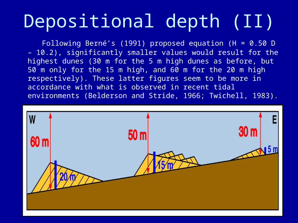
Depositional depth (II) Following Berné’s (1991) proposed equation (H = 0.50 D – 10.2),
significantly smaller values would result for the highest dunes (30 m for the 5 m high dunes as before, but 50 m only for the 15 m high, and 60 m for the 20 m high respectively). These latter figures seem to be more in accordance with what is observed in recent tidal environments (Belderson and Stride, 1966; Twichell, 1983).

Cross-bedding distribution
The observed cross-bedding distribution is similar to that described by Thauront and Berné (1996) in some present-day tidal channels which show a flood-dominated shallower area, an intermediate area with flood- and ebb-dominated structures and a deeper zone with a predominance of ebb-dominated structures. In modern environments, the asymmetry in cross-bedding distribution seems to be related with changes in the velocity and intensity of the flood and ebb currents at different depths (Kranck, 1972; Bartholdy et al., 2002; Le Bot and Trentesaux, 2004; van der Vegt et al., in press). The ebb current dominated the North-Betic Strait generating the largest, west-orientated cross-bedding.
BASIN EVOLUTION AND DIFFERENTIATION OF THE
NORTH-BETIC STRAIT
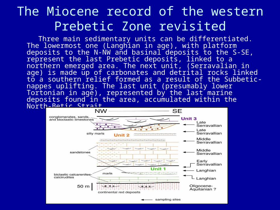
The Miocene record of the western Prebetic Zone revisited
Three main sedimentary units can be differentiated. The lowermost one (Langhian in age), with platform deposits to the N-NW and basinal deposits to the S-SE, represent the last Prebetic deposits, linked to a northern emerged area. The next unit, (Serravalian in age) is made up of carbonates and detrital rocks linked to a southern relief formed as a result of the Subbetic-nappes uplifting. The last unit (presumably lower Tortonian in age), represented by the last marine deposits found in the area, accumulated within the North-Betic Strait.
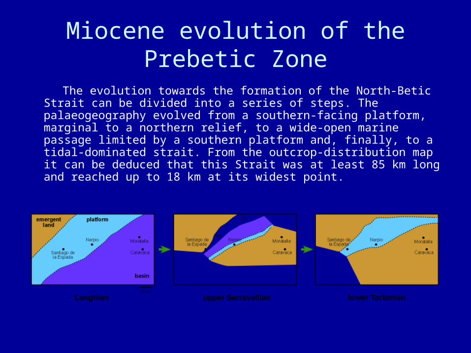
Miocene evolution of the Prebetic Zone
The evolution towards the formation of the North-Betic Strait can be divided into a series of steps. The palaeogeography evolved from a southern-facing platform, marginal to a northern relief, to a wide-open marine passage limited by a southern platform and, finally, to a tidal-dominated strait. From the outcrop-distribution map it can be deduced that this Strait was at least 85 km long and reached up to 18 km at its widest point.
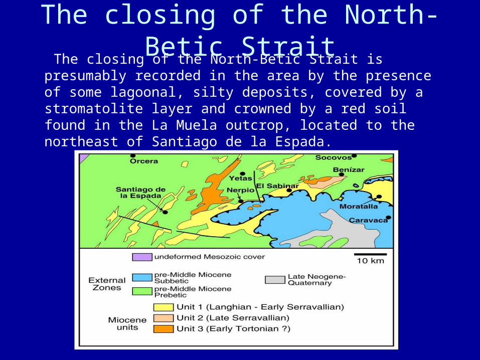
The closing of the North-Betic Strait The closing of the North-Betic Strait is presumably
recorded in the area by the presence of some lagoonal, silty deposits, covered by a stromatolite layer and crowned by a red soil found in the La Muela outcrop, located to the northeast of Santiago de la Espada.
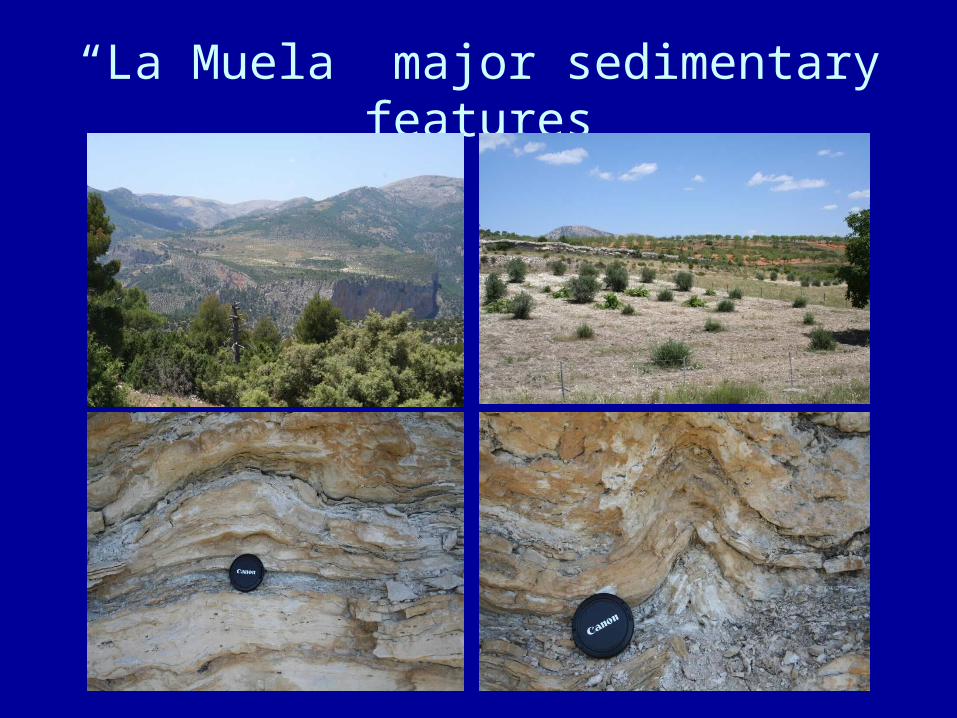
“La Muela” major sedimentary features
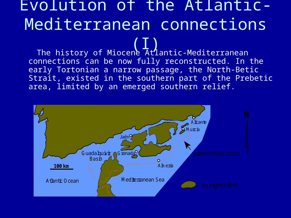
Evolution of the Atlantic-Mediterranean connections (I)
The history of Miocene Atlantic-Mediterranean connections can be now fully reconstructed. In the early Tortonian a narrow passage, the North-Betic Strait, existed in the southern part of the Prebetic area, limited by an emerged southern relief.
Alicante
GuadalquivirBasin
100 km
Jaén
Murcia
Mediterranean SeaAtlantic Oceanemergent land
present-day coast
N
Almería
Granada
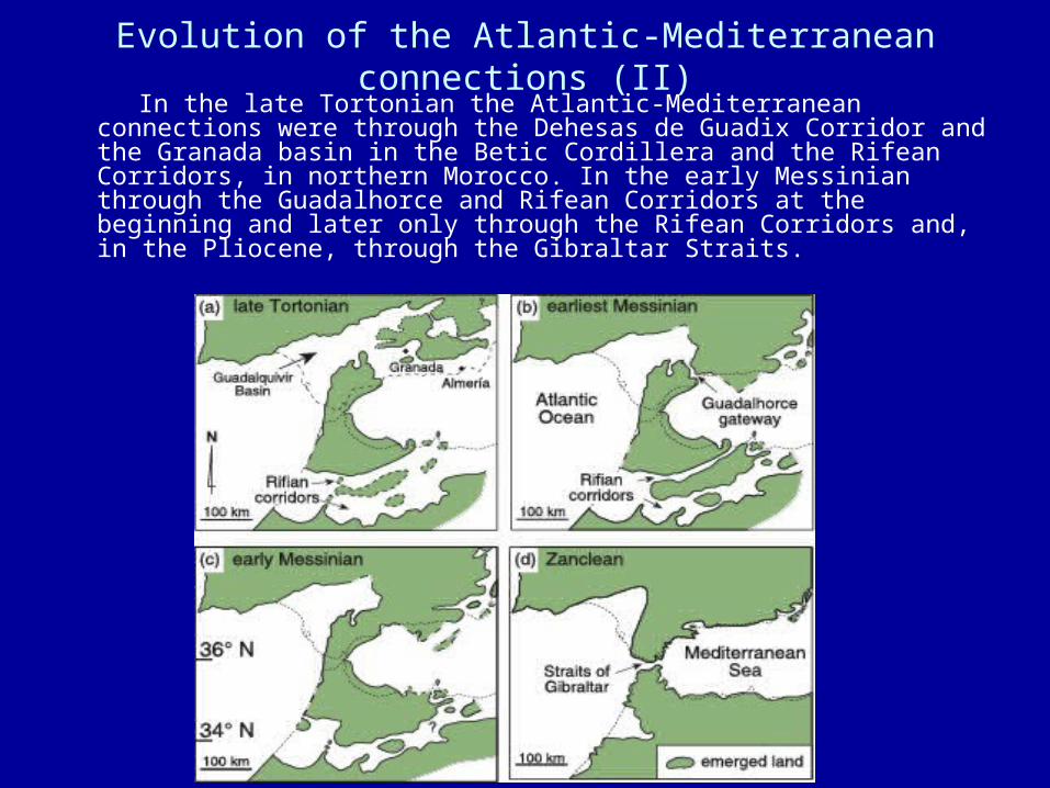
Evolution of the Atlantic-Mediterranean connections (II) In the late Tortonian the Atlantic-Mediterranean connections were
through the Dehesas de Guadix Corridor and the Granada basin in the Betic Cordillera and the Rifean Corridors, in northern Morocco. In the early Messinian through the Guadalhorce and Rifean Corridors at the beginning and later only through the Rifean Corridors and, in the Pliocene, through the Gibraltar Straits.