Embed Size (px)
Citation preview
Title Potential tsunamigenic faults of the 2011 off the Pacific coastof Tohoku Earthquake
Author(s)Tsuji, Takeshi; Ito, Yoshihiro; Kido, Motoyuki; Osada,Yukihito; Fujimoto, Hiromi; Ashi, Juichiro; Kinoshita,Masataka; Matsuoka, Toshifumi
Citation EARTH PLANETS AND SPACE (2011), 63(7): 831-834
Issue Date 2011-09
URL http://hdl.handle.net/2433/171971
Right
© The Society of Geomagnetism and Earth, Planetary andSpace Sciences (SGEPSS); The Seismological Society ofJapan; The Volcanological Society of Japan; The GeodeticSociety of Japan; The Japanese Society for PlanetarySciences;TERRAPUB.
Type Journal Article
Textversion publisher
Kyoto University
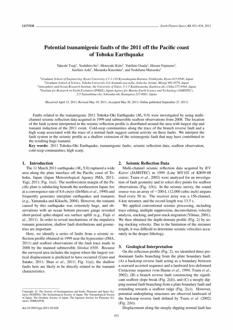
LETTER Earth Planets Space, 63, 831–834, 2011
Potential tsunamigenic faults of the 2011 off the Pacific coastof Tohoku Earthquake
Takeshi Tsuji1, Yoshihiro Ito2, Motoyuki Kido2, Yukihito Osada2, Hiromi Fujimoto2,Juichiro Ashi3, Masataka Kinoshita4, and Toshifumi Matsuoka1
1Graduate School of Engineering, Kyoto University, C1-1-110 Kyotodaigaku-Katsura, Nishikyoku, Kyoto 615-8540, Japan2Graduate School of Science, Tohoku University, 6-6 Aramaki-aza-aoba, Aoba-ku, Sendai, Miyagi 981-8578, Japan
3Atmosphere and Ocean Research Institute, the University of Tokyo, 5-1-5 Kashiwanoha, Kashiwa-shi, Chiba 277-8564, Japan4Institute for Research on Earth Evolution (IFREE), Japan Agency for Marine-Earth Science and Technology (JAMSTEC),
2-5 Natsushima-cho, Yokosuka-shi, Kanagawa 237-0061, Japan
(Received April 13, 2011; Revised May 19, 2011; Accepted May 20, 2011; Online published September 27, 2011)
Faults related to the tsunamigenic 2011 Tohoku-Oki Earthquake (Mw 9.0) were investigated by using multi-channel seismic reflection data acquired in 1999 and submersible seafloor observations from 2008. The locationof the fault system interpreted in the seismic reflection profile is distributed around the area with largest slip andtsunami induction of the 2011 event. Cold-seep communities along the trace of the branch reverse fault and ahigh scarp associated with the trace of a normal fault suggest current activity on these faults. We interpret thefault system in the seismic profile as a shallow extension of the seismogenic fault that may have contributed tothe resulting huge tsunami.Key words: 2011 Tohoku-Oki Earthquake, tsunamigenic faults, seismic reflection data, seafloor observation,cold-seep communities, high scarp.
1. IntroductionThe 11 March 2011 earthquake (Mw 9.0) ruptured a wide
area along the plate interface off the Pacific coast of To-hoku, Japan (Japan Meteorological Agency JMA, 2011;Yagi, 2011; Fig. 1(a)). The northwestern margin of the Pa-cific plate is subducting beneath the northeastern Japan Arcat a convergence rate of 8.6 cm/yr (DeMets et al., 1990) andfrequently generates interplate earthquakes and tsunamis(e.g., Yamanaka and Kikuchi, 2004). However, the tsunamicaused by this earthquake was extremely huge, and ob-servations with an ocean bottom pressure gauge revealedshort-period spike-shaped sea surface uplift (e.g., Fujii etal., 2011). In order to reveal mechanisms of the impulsivetsunami generation, shallow fault distributions and geome-tries are important.
Here, we identify a series of faults from a seismic re-flection profile obtained in 1999 near the hypocenter (JMA,2011) and seafloor observations of the fault trace made in2008 by the manned submersible Shinkai 6500. Becausethe surveyed area includes the region where the largest ver-tical displacement is predicted to have occurred (Ueno andSatake, 2011; Shao et al., 2011; Fig. 1(a)), the shallowfaults here are likely to be directly related to the tsunamicharacteristics.
Copyright c© The Society of Geomagnetism and Earth, Planetary and Space Sci-ences (SGEPSS); The Seismological Society of Japan; The Volcanological Societyof Japan; The Geodetic Society of Japan; The Japanese Society for Planetary Sci-ences; TERRAPUB.
doi:10.5047/eps.2011.05.028
2. Seismic Reflection DataMulti-channel seismic reflection data acquired by R/V
Kairei (JAMSTEC) in 1999 (Line MY102 of KR99-08cruise; Tsuru et al., 2002) were analyzed for an investiga-tion of fault geometry and to select dive points for seafloorobservations (Fig. 1(b)). In the seismic survey, the soundsource was an array of ∼200-L (12,000 cubic inch) airgunsfired every 50 m. The receiver array was a 156-channel,4-km streamer, and the record length was 13.5 s.
We applied conventional seismic processing, includingtrace editing, multiple suppression, deconvolution, velocityanalysis, stacking, and post-stack migration (Yilmaz, 2001).We then obtained the depth-domain profile (Fig. 2) by us-ing stacking velocity. Due to the limitation of the streamerlength, it was difficult to determine seismic velocities accu-rately in the deeper lithology.
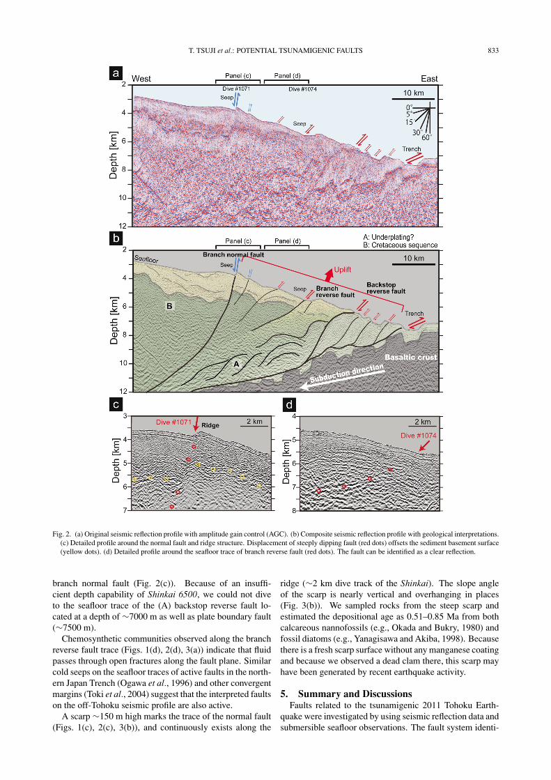
3. Geological InterpretationOn the reflection profile (Fig. 2), we identified three pre-
dominant faults branching from the plate boundary fault:(A) a backstop reverse fault acting as a boundary betweena seaward accreted sequence and a landward less-deformedCretaceous sequence (von Huene et al., 1994; Tsuru et al.,2002), (B) a branch reverse fault constructing the signifi-cant seafloor slope break (Fig. 2(d)), and (C) a steeply dip-ping normal fault branching from a plate boundary fault andextending towards a seafloor ridge (Fig. 2(c)). However,potential underplating structures are observed landward ofthe backstop reverse fault defined by Tsuru et al. (2002)(Fig. 2(b)).
Displacement along the steeply-dipping normal fault has
831
832 T. TSUJI et al.: POTENTIAL TSUNAMIGENIC FAULTS
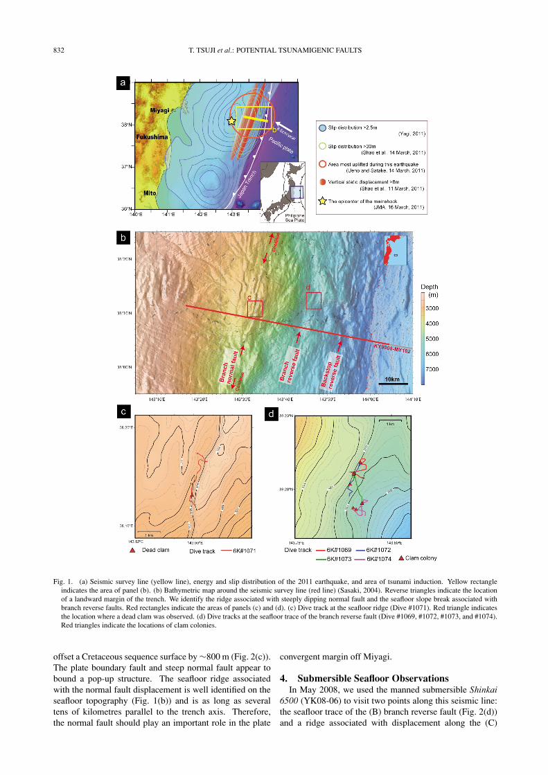
Fig. 1. (a) Seismic survey line (yellow line), energy and slip distribution of the 2011 earthquake, and area of tsunami induction. Yellow rectangleindicates the area of panel (b). (b) Bathymetric map around the seismic survey line (red line) (Sasaki, 2004). Reverse triangles indicate the locationof a landward margin of the trench. We identify the ridge associated with steeply dipping normal fault and the seafloor slope break associated withbranch reverse faults. Red rectangles indicate the areas of panels (c) and (d). (c) Dive track at the seafloor ridge (Dive #1071). Red triangle indicatesthe location where a dead clam was observed. (d) Dive tracks at the seafloor trace of the branch reverse fault (Dive #1069, #1072, #1073, and #1074).Red triangles indicate the locations of clam colonies.
offset a Cretaceous sequence surface by ∼800 m (Fig. 2(c)).The plate boundary fault and steep normal fault appear tobound a pop-up structure. The seafloor ridge associatedwith the normal fault displacement is well identified on theseafloor topography (Fig. 1(b)) and is as long as severaltens of kilometres parallel to the trench axis. Therefore,the normal fault should play an important role in the plate
convergent margin off Miyagi.
4. Submersible Seafloor ObservationsIn May 2008, we used the manned submersible Shinkai
6500 (YK08-06) to visit two points along this seismic line:the seafloor trace of the (B) branch reverse fault (Fig. 2(d))and a ridge associated with displacement along the (C)
T. TSUJI et al.: POTENTIAL TSUNAMIGENIC FAULTS 833
Fig. 2. (a) Original seismic reflection profile with amplitude gain control (AGC). (b) Composite seismic reflection profile with geological interpretations.(c) Detailed profile around the normal fault and ridge structure. Displacement of steeply dipping fault (red dots) offsets the sediment basement surface(yellow dots). (d) Detailed profile around the seafloor trace of branch reverse fault (red dots). The fault can be identified as a clear reflection.
branch normal fault (Fig. 2(c)). Because of an insuffi-cient depth capability of Shinkai 6500, we could not diveto the seafloor trace of the (A) backstop reverse fault lo-cated at a depth of ∼7000 m as well as plate boundary fault(∼7500 m).
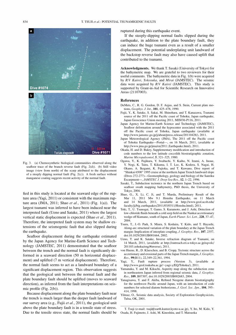
Chemosynthetic communities observed along the branchreverse fault trace (Figs. 1(d), 2(d), 3(a)) indicate that fluidpasses through open fractures along the fault plane. Similarcold seeps on the seafloor traces of active faults in the north-ern Japan Trench (Ogawa et al., 1996) and other convergentmargins (Toki et al., 2004) suggest that the interpreted faultson the off-Tohoku seismic profile are also active.
A scarp ∼150 m high marks the trace of the normal fault(Figs. 1(c), 2(c), 3(b)), and continuously exists along the
ridge (∼2 km dive track of the Shinkai). The slope angleof the scarp is nearly vertical and overhanging in places(Fig. 3(b)). We sampled rocks from the steep scarp andestimated the depositional age as 0.51–0.85 Ma from bothcalcareous nannofossils (e.g., Okada and Bukry, 1980) andfossil diatoms (e.g., Yanagisawa and Akiba, 1998). Becausethere is a fresh scarp surface without any manganese coatingand because we observed a dead clam there, this scarp mayhave been generated by recent earthquake activity.
5. Summary and DiscussionsFaults related to the tsunamigenic 2011 Tohoku Earth-
quake were investigated by using seismic reflection data andsubmersible seafloor observations. The fault system identi-
834 T. TSUJI et al.: POTENTIAL TSUNAMIGENIC FAULTS
Fig. 3. (a) Chemosynthetic biological communities observed along theseafloor trace of the branch reverse fault (Fig. 2(d)). (b) Still videoimage (view from north) of the scarp attributed to the displacementof a steeply dipping normal fault (Fig. 2(c)). A fresh surface withoutmanganese coating suggests recent activity of the normal fault.
fied in this study is located at the seaward edge of the rup-ture area (Yagi, 2011) or consistent with the maximum rup-ture area (JMA, 2011; Shao et al., 2011) (Fig. 1(a)). Thelargest tsunami was inferred to have been induced near theinterpreted fault (Ueno and Satake, 2011) where the largestvertical static displacement is expected (Shao et al., 2011).Therefore, the interpreted fault system may be shallow ex-tensions of the seismogenic fault that also slipped duringthe earthquake.
Seafloor displacement during the earthquake estimatedby the Japan Agency for Marine-Earth Science and Tech-nology (JAMSTEC, 2011) demonstrated that the seafloorbetween the trench and the normal fault is significantly de-formed in a seaward direction (50 m horizontal displace-ment) and uplifted (7 m vertical displacement). Therefore,the normal fault seems to act as a landward boundary of asignificant displacement region. This observation suggeststhat the geological unit between the normal fault and theplate boundary fault should be uplifted (moves to seawarddirection), as inferred from the fault interpretations on seis-mic profile (Fig. 2(b)).
Because displacement along the plate boundary fault nearthe trench is much larger than the deeper fault landward ofour survey area (e.g., Fujii et al., 2011), the geological unitabove the plate boundary fault is in a tensile state of stress.Due to the tensile stress state, the normal faults should be
ruptured during this earthquake event.If the steeply-dipping normal faults slipped during the
earthquake, in addition to the plate boundary fault, theycan induce the huge tsunami even as a result of a smallerdisplacement. The potential underplating unit landward ofthe backstop reverse fault may also have caused uplift thatcontributed to the tsunami.
Acknowledgments. We thank T. Sasaki (University of Tokyo) forthe bathymetric map. We are grateful to two reviewers for theiruseful comments. The bathymetric data in Fig. 1(b) were acquiredby R/V Kairei, Yokosuka, and Mirai (JAMSTEC). The seismicdata were acquired by R/V Kairei (JAMSTEC). This study issupported by Grant-in-Aid for Scientific Research on InnovativeAreas (21107003).
ReferencesDeMets, C., R. G. Gordon, D. F. Argus, and S. Stein, Current plate mo-
tions, Geophys. J. Int., 101, 425–478, 1990.Fujii, Y., K. Satake, S. Sakai, M. Shinohara, and T. Kanazawa, Tsunami
source of the 2011 off the Pacific coast of Tohoku, Japan earthquake,Japan Geoscience Union meeting 2011, MIS036-P116, 2011.
Japan Agency for Marine-Earth Science and Technology (JAMSTEC),Seafloor deformation around the hypocenter associated with the 2011off the Pacific coast of Tohoku, Japan earthquake (available athttp://www.jamstec.go.jp/j/about/press release/20110428/), 2011.
Japan Meteorological Agency (JMA), The 2011 off the Pacific coastof Tohoku Earthquake—Portal—, on 16 March, 2011, (available athttp://www.jma.go.jp/jma/en/2011 Earthquake.html), 2011.
Okada, H. and D. Bukry, Supplementary modification and introduction ofcode numbers to the low latitude coccolith biostratigraphic zonation,Marine Micropaleontol, 5, 321–325, 1980.
Ogawa, Y., K. Fujikura, Y. Iwabuchi, Y. Kaiho, N. Izumi, A. Inoue,Y. Nogi, K. Taira, T. Kikuma, I. T. Lee, K. Kodera, S. Nagai, H.Okano, A. Ikegami, K. Fujioka, and T. Kuwano, Dive report of“Shinkai 6500” 1995 cruise at the northern Japan Trench landward slope(Dives 272-277)—Geomorphology, geology and biology of the SanrikuEscarpment—, JAMSTEC J. Deep Sea Res., 12, 1–22, 1996.
Sasaki, T., Subduction tectonics in the northern Japan Trench based onseafloor swath mapping bathymetry, PhD thesis, the University ofTokyo, 2004.
Shao, G., X. Li, C. Ji, and T. Maeda, Preliminary Result of theMar 11, 2011 Mw 9.1 Honshu Earthquake, on 11 Marchand 14 March, 2011, (available at http://www.geol.ucsb.edu/faculty/ji/big earthquakes/2011/03/0311/Honshu.html), 2011.
Toki, T., U. Tsunogai, T. Gamo, S. Kuramoto, and J. Ashi, Detection oflow-chloride fluids beneath a cold seep field on the Nankai accretioanarywedge off Kumano, south of Japan, Earth Planet. Sci. Lett., 228, 37–47,2004.
Tsuru, T., J.-O. Park, S. Miura, S. Kodaira, Y. Kido, and T. Hayashi,Along-arc structural variation of the plate boundary at the Japan Trenchmargin: Implication of interplate coupling, J. Geophys. Res., 107, 2357,doi:10.1029/2001JB001664, 2002.
Ueno, T. and K. Satake, Inverse refraction diagram of Tsunami, on14 March, 2011, (available at http://outreach.eri.u-tokyo.ac.jp/eqvolc/201103 tohoku/eng/#inverse), 2011.
von Huene, R., D. Klaeschen, and B. Cropp, Tectonic structure across theaccretionary and erosional parts of the Japan Trench margin, J. Geophys.Res., 99(B11), 22,349–22,361, 1994.
Yagi, Y., Fault rupture process (Version 3), (available athttp://www.geol.tsukuba.ac.jp/∼yagi-y/EQ/Tohoku/), 2011.
Yamanaka, Y. and M. Kikuchi, Asperity map along the subduction zonein northeastern Japan inferred from regional seismic data, J. Geophys.Res., 109, B07307, doi:10.1029/2003JB002683, 2004.
Yanagisawa, Y. and F. Akiba, Refined Neogene diatom biostratigraphyfor the northwest Pacific around Japan, with an introduction of codenumbers for selected diatom biohorizons, J. Geol. Soc. Jpn., 104, 395–414, 1998.
Yilmaz, O., Seismic data analysis, Society of Exploration Geophysicists,Tulsa, OK, 2001.
T. Tsuji (e-mail: [email protected]), Y. Ito, M. Kido, Y.Osada, H. Fujimoto, J. Ashi, M. Kinoshita, and T. Matsuoka


![arXiv:1706.03539v1 [cs.DC] 12 Jun 2017 · 2018-11-21 · clude communication faults, logic faults, and so on. 2.2.3 Task restart mechanism A mechanism is needed that manages the task](https://img.pdfslide.tips/doc/110x75/5e51ef611d66bf65fa0bc5bd/arxiv170603539v1-csdc-12-jun-2017-2018-11-21-clude-communication-faults.jpg)