Embed Size (px)
Citation preview
209
IHERINGIA, Sér. Bot., Porto Alegre, v. 66, n.2, p. 209-226, Dez. 2011.
Vegetation communities and their relationship with ...
Vegetation communities and their relationship with the pulse regime on islands of the Middle Paraná River, Argentina
Zuleica Yael Marchetti1 & Pablo Gilberto Aceñolaza1,2
1Centro de Investigación Científica y Transferencia de la Tecnología a la Producción. Materi y España, (CP 3105) Diamante, Entre Ríos, Argentina. [email protected] Autónoma de Entre Ríos. Avenida Ramírez 1143, (CP 3100) Paraná, Entre Ríos, Argentina. [email protected]
Recebido em 21.III.2011. Aceito em 30.XI.2011
ABSTRACT - Vegetation associated to the Paraná River is subject to conditions imposed by the pulse regime. This study aimed to evaluate the pulse regime influence on the vegetation of the Paraná River islands. Using multivariate techniques for classification and ordination, six communities were identified and described: willow forests of marginal levees, riverine forest of internal levees, floating meadows, floating rooted plants, a tall grass herbaceous community and a marshy community. The forests were the most diverse and the richest communities while the floating meadows and the marshy community were less rich and diverse. Our results indicate that duration and recurrence of floods are important variables in determining the characteristics of the vegetation. However, forests with a similar flood recurrence and duration showed important differences in physiognomy, structure and floris-tic composition. The differences between the forests could be explained by the connectivity degree, geomorphological dynamics and succession time.
Key words: vegetation assemblages, diversity, hydrological dynamics, water energy
RESUMO – Comunidades vegetais e sua relação com o regime de pulso em ilhas do Paraná, Argentina. A vegetação associada ao rio Paraná está sujeita ao regime do pulso. O objetivo deste estudo é avaliar como o pulso influencia a vegetação em ilhas do rio Paraná. Após aplicação de técnicas multivariadas, seis comunidades foram identificadas e descritas: mata de salgueiro de diques marginais, mata ciliar de diques internos, vegetação aquática flu-tuante, comunidade aquática arraigada, comunidade herbáceas de grama alta e comunidade pantanosa. As matas foram os mais diversos e o mais rico entre as comunidades. Entretanto, as vegetações flutuantes e pantanosas foram menos ricas e diversas. Nossos resultados indi-cam que o tempo e periodicidade das inundações é uma variável importante para determinar as características da vegetação. No entanto, a mata, com semelhantes periodicidade e dura-ção de inundações mostrou diferenças na fisionomia, estrutura e composição florística.
Palavras chave: comunidades vegetais, gradiente de inundação, diversidade e riqueza, ener-gia da água
INTRODUCTION
The growing and diverse literature on wetland environments, communities and ecological proces-ses has turned this issue into one of the most docu-mented topics in recent years (Bournette et al., 1998; Ward et al., 1999; Van Coller et al., 2000; Panitsa &
Tzanoudakis, 2001; Decocq, 2002; Campos & Sou-za, 2002; Finlayson, 2005; Stoll et. al., 2006; Budke & Jarenkow, 2007; Sarr & Hibbs, 2007; Martins et al., 2008). Wetlands are increasingly considered as macrosystems that provide several environmental services: sources of clear water, wildlife habitat, or-ganic material production, fertilizer decomposition
210
IHERINGIA, Sér. Bot., Porto Alegre, v. 66, n.2, p. 209-226, Dez. 2011.
MARCHETTI, Z. Y. & ACEÑOLAZA, P. G.
and river shore stabilization are just a few examples of them (Neiff, 1997; Carvalho et al., 2005).
The Paraná River is the second most important river in South America (Franceschi et al., 2000) and it has been identified as a fluvial system of rema-rkable characteristics at a global level (Neiff, 1996, 1999) because it originates in a humid tropical cli-mate and ends in a humid temperate region (Aceño-laza et al., 2004; Oakley et al., 2005). In Argentina, an important quantity of simple and composed islan-ds is distributed along the main channel of the Para-ná River and they are among the most representative geomorphological elements/units (according to its development degree) of the Paraná River. The floo-dplain of the Paraná River, where the islands are an important geomorphological element, covers 7,200 km2 only in the Middle Paraná (Drago, 1981). Both the floodplain and the islands of the main channel are subject to the influence of hydro-sedimentologi-cal pulses of the river (Neiff 1990, 1996, 1999). In the spring-summer period a high water phase or an ordinary flood phase occurs once a year. During this high water phase the river has a flow of up to 25,000 m3 s-1 and it is followed by a low water phase from the end of winter to the beginning of spring. In unu-sual floods, the river may reach a flow of 60,000 m3
s-1 (Neiff, 1979), triggering substantial changes in vegetation (Franceschi et al., 2000) as well as impor-tant economic losses.
This variability in the hydrological dynamics determines the structure and evolution of the floo-dplain and of the islands in the main channel of the Paraná River (Lewis & Franceschi, 1979; Neiff, 1996; Ramonell et al., 2000). Moreover, this varia-bility produces a significant heterogeneity, which is characterized by high species richness and diversity (Aceñolaza et al., 2004, 2005, 2008) and complex ecological processes. The role of vegetation was stu-died in the low Paraguay River (the major tributary of the Paraná River) by Neiff et al. (2006), who found that the vegetation in the floodplain produced a re-duction of runoff up to 25 % during the extraordina-ry flood of 1982. However, it should be pointed out that the “buffer” function of the vegetation depends on its structure, diversity, biomass and distribution. In this regard, the study of such characteristics in different vegetation types constitutes a key step in environments characterized by a high hydrological variability. Only from this point the relationship be-tween the vegetation and the pulse regime can be un-derstood and the associated environmental functions of the vegetation can be valued.
Several studies have been conducted on the vegetation of environments associated to the Para-ná River (Neiff, 1979, 1986; Kandus et al., 2003; Aceñolaza et al., 2004; Marchetti & Aceñolaza, 2005; Casco et. al., 2005; Aceñolaza et al., 2008; Sione et al., 2009); nevertheless, phytosociological analyses of the vegetation, the relative importan-ce of species in different vegetation units and their relationship with the pulse regime are scarce in the middle section of the Parana River (Franceschi & Lewis, 1979; Franceschi et. al., 1985; Aceñolaza & Muñoz, 2003). Moreover, the topographic level as a key factor in relation to the pulse regime and the colonization range of vegetation units on islands of the main channel are unknown. This work had two aims: 1- to define vegetation communities on islands of the main channel and 2- to assess the effect of the pulse regime on their structure and specific compo-sition according to their location along the topogra-phic gradient.
METHODS
Study Area
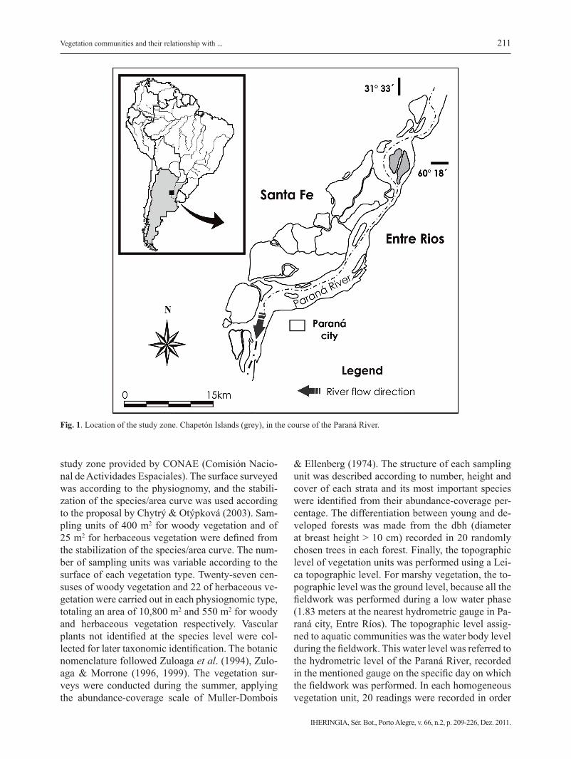
The study was carried out on the Chapeton Is-lands in the main channel of the Paraná River in Entre Ríos Province, Argentina (31° 33´49´´ S, 60° 18´21´´ W). The study zone covers 1,500 hectares (Fig.1) and it was chosen because it combines ve-getation units and geomorphological elements, whi-ch are representative of the main environments as-sociated to the Middle Paraná River. Alluvial soils (Entisols) have textures ranging from silty, clayey to sandy or any combination thereof, usually without an evolved profile. The climate is humid, temperate/warm, with a mean annual temperature of 19 ºC and an annual rainfall of 900 mm, with most rains (73 %) from October to April (Rojas & Saluso, 1987). The extensive livestock is widely developed in the study zone and it involves fire as the main management practice at the end of winter (Sione et al., 2009). The pulse regime, represented by high and low, ordinary and extraordinary water phases, characterizes the su-perficial hydrology in the study zone.
Vegetation analysis
Homogeneous vegetation units were identified using Landsat TM 7 satellite images (2006) of the
211
IHERINGIA, Sér. Bot., Porto Alegre, v. 66, n.2, p. 209-226, Dez. 2011.
Vegetation communities and their relationship with ...
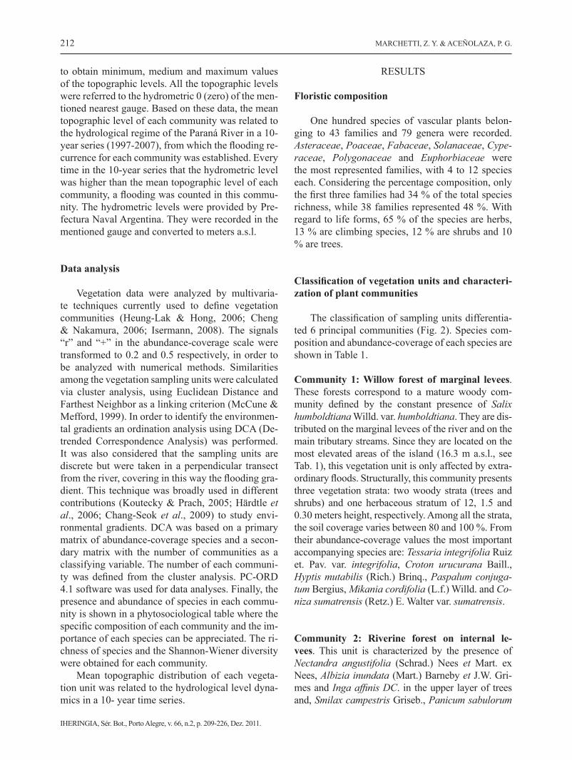
study zone provided by CONAE (Comisión Nacio-nal de Actividades Espaciales). The surface surveyed was according to the physiognomy, and the stabili-zation of the species/area curve was used according to the proposal by Chytrý & Otýpková (2003). Sam-pling units of 400 m2 for woody vegetation and of 25 m2 for herbaceous vegetation were defined from the stabilization of the species/area curve. The num-ber of sampling units was variable according to the surface of each vegetation type. Twenty-seven cen-suses of woody vegetation and 22 of herbaceous ve-getation were carried out in each physiognomic type, totaling an area of 10,800 m2 and 550 m2 for woody and herbaceous vegetation respectively. Vascular plants not identified at the species level were col-lected for later taxonomic identification. The botanic nomenclature followed Zuloaga et al. (1994), Zulo-aga & Morrone (1996, 1999). The vegetation sur-veys were conducted during the summer, applying the abundance-coverage scale of Muller-Dombois
& Ellenberg (1974). The structure of each sampling unit was described according to number, height and cover of each strata and its most important species were identified from their abundance-coverage per-centage. The differentiation between young and de-veloped forests was made from the dbh (diameter at breast height > 10 cm) recorded in 20 randomly chosen trees in each forest. Finally, the topographic level of vegetation units was performed using a Lei-ca topographic level. For marshy vegetation, the to-pographic level was the ground level, because all the fieldwork was performed during a low water phase (1.83 meters at the nearest hydrometric gauge in Pa-raná city, Entre Ríos). The topographic level assig-ned to aquatic communities was the water body level during the fieldwork. This water level was referred to the hydrometric level of the Paraná River, recorded in the mentioned gauge on the specific day on which the fieldwork was performed. In each homogeneous vegetation unit, 20 readings were recorded in order
Fig. 1. Location of the study zone. Chapetón Islands (grey), in the course of the Paraná River.
212
IHERINGIA, Sér. Bot., Porto Alegre, v. 66, n.2, p. 209-226, Dez. 2011.
MARCHETTI, Z. Y. & ACEÑOLAZA, P. G.
to obtain minimum, medium and maximum values of the topographic levels. All the topographic levels were referred to the hydrometric 0 (zero) of the men-tioned nearest gauge. Based on these data, the mean topographic level of each community was related to the hydrological regime of the Paraná River in a 10-year series (1997-2007), from which the flooding re-currence for each community was established. Every time in the 10-year series that the hydrometric level was higher than the mean topographic level of each community, a flooding was counted in this commu-nity. The hydrometric levels were provided by Pre-fectura Naval Argentina. They were recorded in the mentioned gauge and converted to meters a.s.l.
Data analysis
Vegetation data were analyzed by multivaria-te techniques currently used to define vegetation communities (Heung-Lak & Hong, 2006; Cheng & Nakamura, 2006; Isermann, 2008). The signals “r” and “+” in the abundance-coverage scale were transformed to 0.2 and 0.5 respectively, in order to be analyzed with numerical methods. Similarities among the vegetation sampling units were calculated via cluster analysis, using Euclidean Distance and Farthest Neighbor as a linking criterion (McCune & Mefford, 1999). In order to identify the environmen-tal gradients an ordination analysis using DCA (De-trended Correspondence Analysis) was performed. It was also considered that the sampling units are discrete but were taken in a perpendicular transect from the river, covering in this way the flooding gra-dient. This technique was broadly used in different contributions (Koutecky & Prach, 2005; Härdtle et al., 2006; Chang-Seok et al., 2009) to study envi-ronmental gradients. DCA was based on a primary matrix of abundance-coverage species and a secon-dary matrix with the number of communities as a classifying variable. The number of each communi-ty was defined from the cluster analysis. PC-ORD 4.1 software was used for data analyses. Finally, the presence and abundance of species in each commu-nity is shown in a phytosociological table where the specific composition of each community and the im-portance of each species can be appreciated. The ri-chness of species and the Shannon-Wiener diversity were obtained for each community.
Mean topographic distribution of each vegeta-tion unit was related to the hydrological level dyna-mics in a 10- year time series.
RESULTS
Floristic composition
One hundred species of vascular plants belon-ging to 43 families and 79 genera were recorded. Asteraceae, Poaceae, Fabaceae, Solanaceae, Cype-raceae, Polygonaceae and Euphorbiaceae were the most represented families, with 4 to 12 species each. Considering the percentage composition, only the first three families had 34 % of the total species richness, while 38 families represented 48 %. With regard to life forms, 65 % of the species are herbs, 13 % are climbing species, 12 % are shrubs and 10 % are trees.
Classification of vegetation units and characteri-zation of plant communities
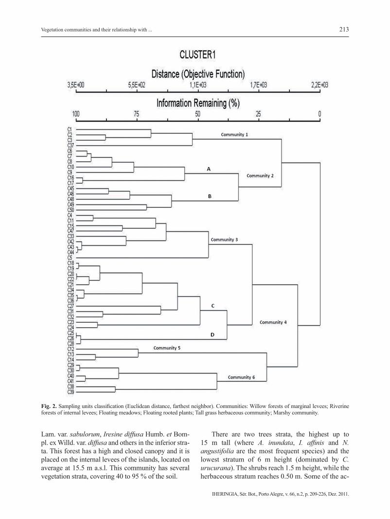
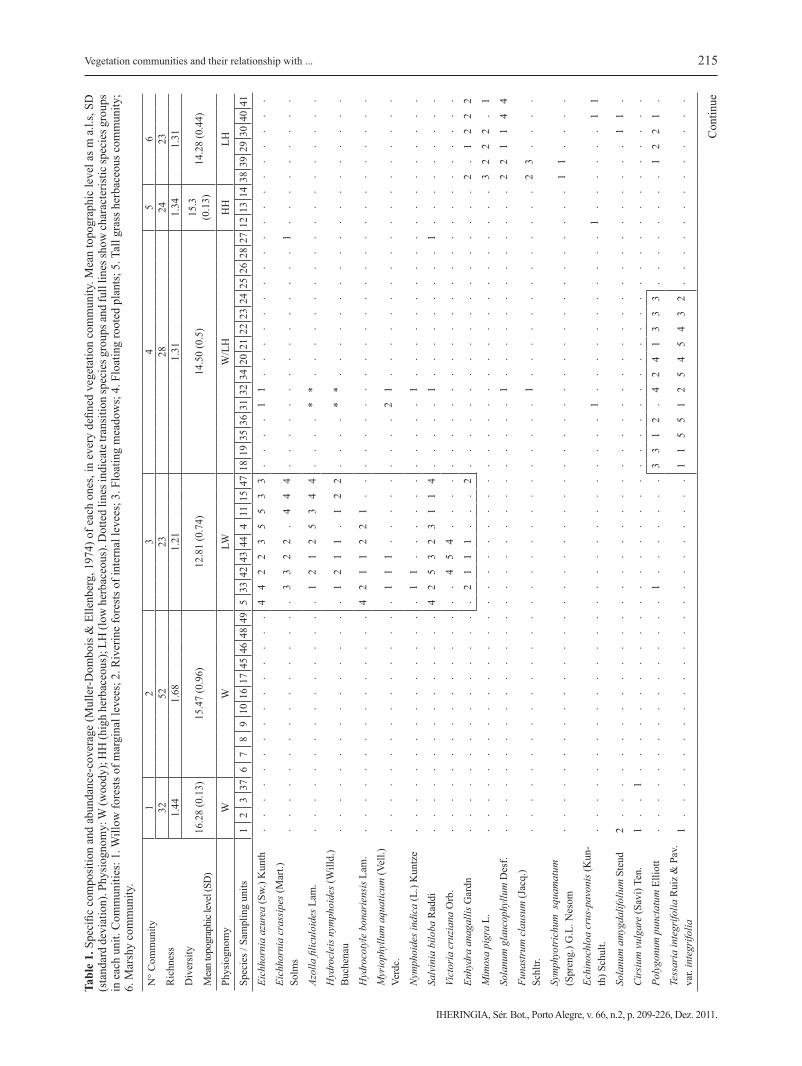
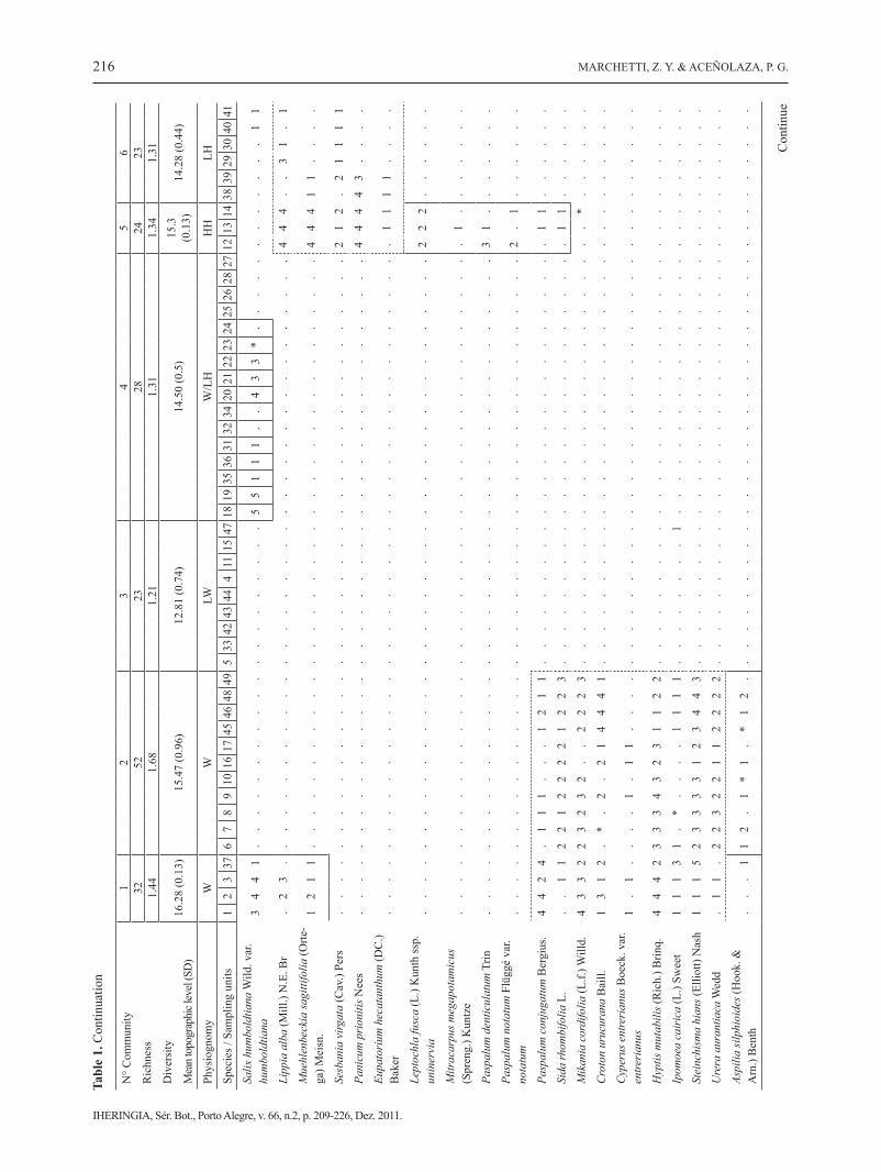
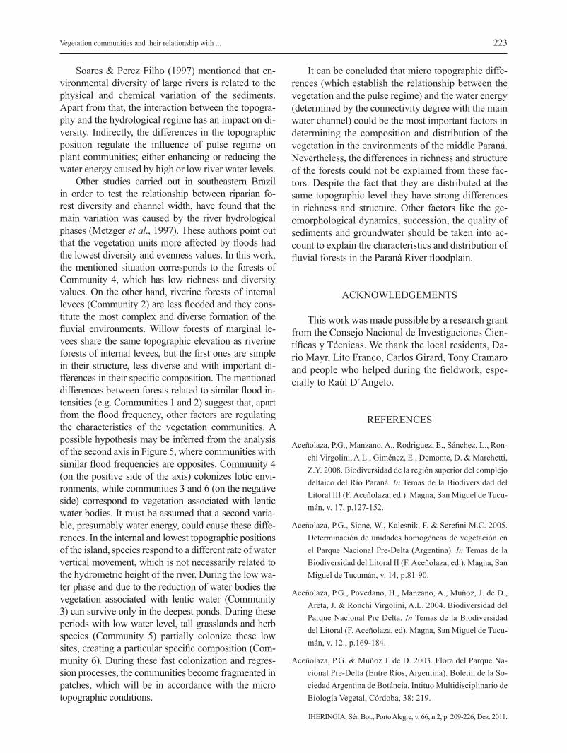
The classification of sampling units differentia-ted 6 principal communities (Fig. 2). Species com-position and abundance-coverage of each species are shown in Table 1.
Community 1: Willow forest of marginal levees. These forests correspond to a mature woody com-munity defined by the constant presence of Salix humboldtiana Willd. var. humboldtiana. They are dis-tributed on the marginal levees of the river and on the main tributary streams. Since they are located on the most elevated areas of the island (16.3 m a.s.l., see Tab. 1), this vegetation unit is only affected by extra-ordinary floods. Structurally, this community presents three vegetation strata: two woody strata (trees and shrubs) and one herbaceous stratum of 12, 1.5 and 0.30 meters height, respectively. Among all the strata, the soil coverage varies between 80 and 100 %. From their abundance-coverage values the most important accompanying species are: Tessaria integrifolia Ruiz et. Pav. var. integrifolia, Croton urucurana Baill., Hyptis mutabilis (Rich.) Brinq., Paspalum conjuga-tum Bergius, Mikania cordifolia (L.f.) Willd. and Co-niza sumatrensis (Retz.) E. Walter var. sumatrensis.
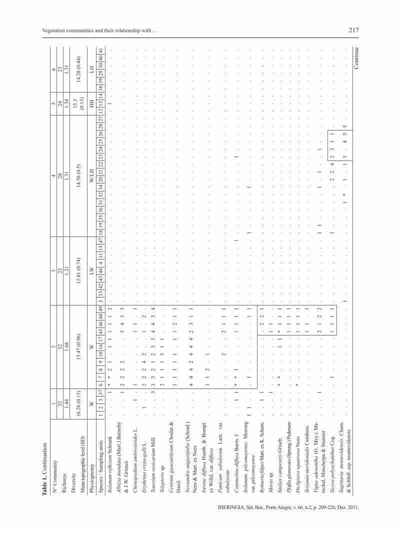
Community 2: Riverine forest on internal le-vees. This unit is characterized by the presence of Nectandra angustifolia (Schrad.) Nees et Mart. ex Nees, Albizia inundata (Mart.) Barneby et J.W. Gri-mes and Inga affinis DC. in the upper layer of trees and, Smilax campestris Griseb., Panicum sabulorum
213
IHERINGIA, Sér. Bot., Porto Alegre, v. 66, n.2, p. 209-226, Dez. 2011.
Vegetation communities and their relationship with ...
Lam. var. sabulorum, Iresine diffusa Humb. et Bom-pl. ex Willd. var. diffusa and others in the inferior stra-ta. This forest has a high and closed canopy and it is placed on the internal levees of the islands, located on average at 15.5 m a.s.l. This community has several vegetation strata, covering 40 to 95 % of the soil.
There are two trees strata, the highest up to 15 m tall (where A. inundata, I. affinis and N. angustifolia are the most frequent species) and the lowest stratum of 6 m height (dominated by C. urucurana). The shrubs reach 1.5 m height, while the herbaceous stratum reaches 0.50 m. Some of the ac-
Fig. 2. Sampling units classification (Euclidean distance, farthest neighbor). Communities: Willow forests of marginal levees; Riverine forests of internal levees; Floating meadows; Floating rooted plants; Tall grass herbaceous community; Marshy community.
214
IHERINGIA, Sér. Bot., Porto Alegre, v. 66, n.2, p. 209-226, Dez. 2011.
MARCHETTI, Z. Y. & ACEÑOLAZA, P. G.
companying species are: Solanum reflexum Schrank, Vigna adenantha (G. Mey.) Marechal, Mascherpa et Stainer, M. cordifolia, Aspilia silphioides (Hook. et Arn.) Benth., Sicyos polyachanthus Cog. and Urera aurantiaca Wedd. Based on Figure 2, it is possi-ble to distinguish two sub-communities: Nectandra angustifolia riverine forests (Fig. 2 A) and Albizia inundata and Croton urucurana riverine forests (Fig. 2 B).
Community 3: Floating meadows. These commu-nities colonize ponds and old watercourses (mean-der scrolls, oxbow ponds) and are disconnected from the main channel. The water level was 12.8 m a.s.l during the field work (1.83 m in the Paraná River). For this hydrometric level, these old watercourses are lentic or semilentic environments; the latter may become lotic during the floods, which change the water level and the specific composition. Although this unit has a low number of species, a gradient in its specific composition can be observed from the shoreline to the open water zone. Up to 0.30 m in depth, the more frequent species are Myriophyllum aquaticum (Vell.) Verdc., Hydrocotyle bonariensis Lam., Polygonum punctatum Elliott, and Salvinia biloba Raddi, among others. Floating species, such as Eichhornia crassipes (Mart.) Solms and Eichhor-nia azurea (Sw.) Kunth become dominant as dep-th increases. Victoria cruziana Orb., Limnobium laevigatum (Humb. et Bonpl. ex Willd.) Heine, E. crassipes, E. azurea and Azolla filiculoides Lam. are frequent in the deepest zone of the ponds. Because of the high growth rate of some aquatic species, mo-nospecific stands can establish covering up to a 100 % of the water surface.
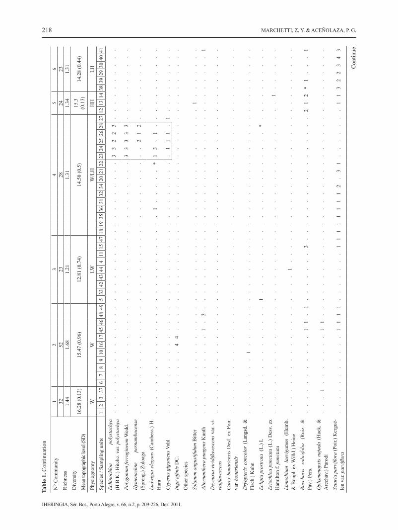
Community 4: Floating rooted plants. This vege-tation unit includes a set of species distributed at an average elevation of 14.5 m a.s.l. in direct contact with the main water channel (river or stream). This unit is characterized by two subgroups, woody and herbaceous respectively. The first one includes small forests of T. integrifolia and S. humboldtiana (Fig. 2 C), which are represented by trees with small dia-meters and high density. In general, these pioneer forests are monospecific, with one species as domi-nant and the others accompanying. They are struc-turally homogeneous, presenting a layer of trees of up to 10 m tall, which covers more than 80 %. The herbaceous vegetation is very scarce in these forests.
Only isolated plants of P. punctatum, L. elegans and E. crassipes can be found after a flood. Mikania periplocifolia and V. adenantha are the most com-mon accompanying species. In the herbaceous sub-group (Fig. 2 D), its most important species form a sequence of a contiguous belt of vegetation: the first belt is represented by Panicum elephantipes Nees ex Trin, it is in direct contact with the river and it reaches from 0.40 to 0.60 m tall and covers 100 % of the soil/water surface; the second belt is represented by Echinochloa polystachya (H.B.K.) Hitchc. var. polystachya, it reaches 2 m tall and covers 100 % of the soil/water surface; the third belt, of more than 2 m tall, is represented by Polygonum ferrugineum Wedd., E. polystachya and Echinochloa crus-pavonis (Kunth) Schult. with similar coverage values. The accompanying species are Commelina diffusa Burm. f., Ludwigia elegans (Cambess.) H. Hara and Mikania periplicofolia Hook. et Arn., among others.
Community 5: Tall grass. Dominated by Panicum prionitis Nees and located approximately at 15.3 m a.s.l. This community is found between levees and ponds, being one of the most representative herba-ceous communities in the floodplain of the Parana River. Structurally, it presents two vegetation stra-ta: the one on the top, of up to 3 m tall, composed by P. prionitis and, to a lesser extent, by shrubs such as Sesbania virgata (Cav.) Pers and Mimosa pigra L., and the bottom stratum, of about 0.50 m tall, composed by accompanying species found at equivalent frequencies in other communities: Cynodon dactylon (L.) Pers. var. dactylon, Setaria parviflora (Poir.) Kerguélen var. parviflora, C. sumatrensis, etc. Leptochla fusca (L.) Kunth ssp. uninervia, Mitracarpus megapotamicus (Spreng.) Kuntze, Paspalum denticulatum Trin., Paspalum notatum Flüggé var. notatum are exclusive and very frequent species in this community. There are also climbing species such as Muehlenbeckia sagittifolia (Ortega) Meisn, Solanum angustifidum Bitter. This is the richest herbaceous community of the islands.
Community 6: Marshy community. This vegetation unit is found between the tall grasslands (Community 5) and the littoral zone of the ponds, in an average to-pographic position of 14.3 m a.s.l. Depending on the water level, it may include completely flooded areas with aquatic vegetation or unflooded ones during the low water phase. In any case, the vegetation is mostly
215
IHERINGIA, Sér. Bot., Porto Alegre, v. 66, n.2, p. 209-226, Dez. 2011.
Vegetation communities and their relationship with ...
N° C
omm
unity
Ric
hnes
s
Div
ersi
ty
Mea
n to
pogr
aphi
c lev
el (S
D)
12
34
56
3252
2328
2423
1.44
1.68
1.21
1.31
1.34
1.31
16.2
8 (0
.13)
15.4
7 (0
.96)
12.8
1 (0
.74)
14.5
0 (0
.5)
15.3
(0
.13)
14.2
8 (0
.44)
Phys
iogn
omy
WW
LWW
/LH
HH
LH
Spec
ies /
Sam
plin
g un
its1
23
376
78
910
1617
4546
4849
533
4243
444
1115
4718
1935
3631
3234
2021
2223
2425
2628
2712
1314
3839
2930
4041
Eich
horn
ia a
zure
a (S
w.) K
unth
..
..
..
..
..
..
..
.4
42
23
55
33
..
..
11
..
..
..
..
..
..
..
..
..
.
Eich
horn
ia c
rass
ipes
(Mar
t.)
Solm
s.
..
..
..
..
..
..
..
.3
32
2.
44
4.
..
..
..
..
..
..
..
1.
..
..
..
..
Azol
la fi
licul
oide
s Lam
..
..
..
..
..
..
..
..
.1
21
25
34
4.
..
.*
*.
..
..
..
..
..
..
..
..
..
Hyd
rocl
eis n
ymph
oide
s (W
illd.
) B
uche
nau
..
..
..
..
..
..
..
..
12
11
.1
22
..
..
**
..
..
..
..
..
..
..
..
..
.
Hyd
roco
tyle
bon
arie
nsis
Lam
..
..
..
..
..
..
..
..
42
11
22
1.
..
..
..
..
..
..
..
..
..
..
..
..
..
Myr
ioph
yllu
m a
quat
icum
(Vel
l.)
Verd
c..
..
..
..
..
..
..
..
.1
11
..
..
..
..
.2
1.
..
..
..
..
..
..
..
..
..
Nym
phoi
des i
ndic
a (L
.) K
untz
e.
..
..
..
..
..
..
..
.1
1.
..
..
..
..
..
1.
..
..
..
..
..
..
..
..
..
Salv
inia
bilo
ba R
addi
..
..
..
..
..
..
..
.4
25
32
31
14
..
..
.1
..
..
..
..
.1
..
..
..
..
.
Vict
oria
cru
zian
a O
rb.
..
..
..
..
..
..
..
..
.4
54
..
..
..
..
..
..
..
..
..
..
..
..
..
..
.
Enhy
dra
anag
allis
Gar
dn.
..
..
..
..
..
..
..
.2
11
1.
..
2.
..
..
..
..
..
..
..
..
..
2.
12
22
Mim
osa
pigr
a L.
..
..
..
..
..
..
..
..
..
..
..
..
..
..
..
..
..
..
..
..
..
.3
22
2.
1
Sola
num
gla
ucop
hyllu
m D
esf.
..
..
..
..
..
..
..
..
..
..
..
..
..
..
.1
..
..
..
..
..
..
.2
21
14
4
Funa
stru
m c
laus
um (J
acq.
) Sc
hltr.
..
..
..
..
..
..
..
..
..
..
..
..
..
..
.1
..
..
..
..
..
..
.2
3.
..
.
Sym
phyo
tric
hum
squ
amat
um
(Spr
eng.
) G.L
. Nes
om.
..
..
..
..
..
..
..
..
..
..
..
..
..
..
..
..
..
..
..
..
..
11
..
..
Echi
noch
loa
crus
-pav
onis
(Kun
-th
) Sch
ult.
..
..
..
..
..
..
..
..
..
..
..
..
..
..
1.
..
..
..
..
..
1.
..
..
.1
1
Sola
num
am
ygda
lifol
ium
Ste
ud2
..
..
..
..
..
..
..
..
..
..
..
..
..
..
..
..
..
..
..
..
..
..
.1
1.
Cir
sium
vul
gare
(Sav
i) Te
n.1
..
1.
..
..
..
..
..
..
..
..
..
..
..
..
..
..
..
..
..
..
..
..
..
..
Poly
gonu
m p
unct
atum
Elli
ott
..
..
..
..
..
..
..
..
1.
..
..
..
33
12
.4
24
13
33
..
..
..
..
12
21
.
Tess
aria
inte
grifo
lia R
uiz
& P
av.
var.
inte
grifo
lia1
..
..
..
..
..
..
..
..
..
..
..
.1
15
51
25
45
43
2.
..
..
..
..
..
..
Tabl
e 1.
Spe
cific
com
posi
tion
and
abun
danc
e-co
vera
ge (M
ulle
r-Dom
bois
& E
llenb
erg,
197
4) o
f eac
h on
es, i
n ev
ery
defin
ed v
eget
atio
n co
mm
unity
. Mea
n to
pogr
aphi
c le
vel a
s m a
.l.s,
SD
(sta
ndar
d de
viat
ion)
. Phy
siog
nom
y: W
(woo
dy);
HH
(hig
h he
rbac
eous
); LH
(low
her
bace
ous)
. Dot
ted
lines
indi
cate
tran
sitio
n sp
ecie
s gro
ups a
nd fu
ll lin
es sh
ow ch
arac
teris
tic sp
ecie
s gro
ups
in e
ach
unit.
Com
mun
ities
: 1. W
illow
fore
sts o
f mar
gina
l lev
ees;
2. R
iver
ine
fore
sts o
f int
erna
l lev
ees;
3. F
loat
ing
mea
dow
s; 4
. Flo
atin
g ro
oted
pla
nts;
5. T
all g
rass
her
bace
ous c
omm
unity
; 6.
Mar
shy
com
mun
ity.
Con
tinue
216
IHERINGIA, Sér. Bot., Porto Alegre, v. 66, n.2, p. 209-226, Dez. 2011.
MARCHETTI, Z. Y. & ACEÑOLAZA, P. G.
Tabl
e 1.
Con
tinua
tion
Con
tinue
N° C
omm
unity
Ric
hnes
s
Div
ersi
ty
Mea
n to
pogr
aphi
c lev
el (S
D)
12
34
56
3252
2328
2423
1.44
1.68
1.21
1.31
1.34
1.31
16.2
8 (0
.13)
15.4
7 (0
.96)
12.8
1 (0
.74)
14.5
0 (0
.5)
15.3
(0
.13)
14.2
8 (0
.44)
Phys
iogn
omy
WW
LWW
/LH
HH
LH
Spec
ies /
Sam
plin
g un
its1
23
376
78
910
1617
4546
4849
533
4243
444
1115
4718
1935
3631
3234
2021
2223
2425
2628
2712
1314
3839
2930
4041
Salix
hum
bold
tiana
Wild
. var
. hu
mbo
ldtia
na3
44
1.
..
..
..
..
..
..
..
..
..
.5
51
11
..
43
3*
..
..
..
..
..
..
11
Lipp
ia a
lba
(Mill
.) N
.E. B
r.
23
..
..
..
..
..
..
..
..
..
..
..
..
..
..
..
..
..
..
.4
44
..
31
.1
Mue
hlen
beck
ia sa
gitti
folia
(Orte
-ga
) Mei
sn.
12
11
..
..
..
..
..
..
..
..
..
..
..
..
..
..
..
..
..
..
44
41
1.
..
.
Sesb
ania
virg
ata
(Cav
.) Pe
rs.
..
..
..
..
..
..
..
..
..
..
..
..
..
..
..
..
..
..
..
.2
12
.2
11
11
Pani
cum
pri
oniti
s Nee
s.
..
..
..
..
..
..
..
..
..
..
..
..
..
..
..
..
..
..
..
.4
44
43
..
..
Eupa
tori
um h
ecat
anth
um (D
C.)
Bak
er.
..
..
..
..
..
..
..
..
..
..
..
..
..
..
..
..
..
..
..
..
11
11
..
..
Lept
ochl
a fu
sca
(L.)
Kun
th ss
p.
unin
ervi
a.
..
..
..
..
..
..
..
..
..
..
..
..
..
..
..
..
..
..
..
.2
22
..
..
..
Mitr
acar
pus m
egap
otam
icus
(S
pren
g.) K
untz
e.
..
..
..
..
..
..
..
..
..
..
..
..
..
..
..
..
..
..
..
..
1.
..
..
..
Pasp
alum
den
ticul
atum
Trin
..
..
..
..
..
..
..
..
..
..
..
..
..
..
..
..
..
..
..
..
31
..
..
..
.
Pasp
alum
not
atum
Flü
ggé
var.
nota
tum
..
..
..
..
..
..
..
..
..
..
..
..
..
..
..
..
..
..
..
..
2.
1.
..
..
.
Pasp
alum
con
juga
tum
Ber
gius
.4
42
4.
11
1.
..
12
11
..
..
..
..
..
..
..
..
..
..
..
..
..
11
..
..
..
Sida
rhom
bifo
lia L
..
.1
12
21
22
22
12
23
..
..
..
..
..
..
..
..
..
..
..
..
..
11
..
..
..
Mik
ania
cor
difo
lia (L
.f.) W
illd.
43
32
23
23
2.
.2
22
3.
..
..
..
..
..
..
..
..
..
..
..
..
..
*.
..
..
.
Cro
ton
uruc
uran
a B
aill.
13
12
.*
.2
.2
14
44
1.
..
..
..
..
..
..
..
..
..
..
..
..
..
..
..
..
.
Cyp
erus
ent
reri
anus
Boe
ck. v
ar.
entre
rian
us1
.1
..
..
1.
11
..
..
..
..
..
..
..
..
..
..
..
..
..
..
..
..
..
..
..
Hyp
tis m
utab
ilis (
Ric
h.) B
rinq.
44
42
33
34
32
31
12
2.
..
..
..
..
..
..
..
..
..
..
..
..
..
..
..
..
.
Ipom
oea
cair
ica
(L.)
Swee
t1
11
31
.*
..
..
11
11
..
..
..
..
1.
..
..
..
..
..
..
..
..
..
..
..
..
Stei
nchi
sma
hian
s (El
liott)
Nas
h1
11
52
33
33
12
34
43
..
..
..
..
..
..
..
..
..
..
..
..
..
..
..
..
..
Ure
ra a
uran
tiaca
Wed
d.
11
.2
23
22
11
22
22
..
..
..
..
..
..
..
..
..
..
..
..
..
..
..
..
..
Aspi
lia si
lphi
oide
s (H
ook.
&
Arn
.) B
enth
..
.1
12
.1
*1
.*
12
..
..
..
..
..
..
..
..
..
..
..
..
..
..
..
..
..
.
217
IHERINGIA, Sér. Bot., Porto Alegre, v. 66, n.2, p. 209-226, Dez. 2011.
Vegetation communities and their relationship with ...
Tabl
e 1.
Con
tinua
tion
Con
tinue
N° C
omm
unity
Ric
hnes
s
Div
ersi
ty
Mea
n to
pogr
aphi
c lev
el (S
D)
12
34
56
3252
2328
2423
1.44
1.68
1.21
1.31
1.34
1.31
16.2
8 (0
.13)
15.4
7 (0
.96)
12.8
1 (0
.74)
14.5
0 (0
.5)
15.3
(0
.13)
14.2
8 (0
.44)
Phys
iogn
omy
WW
LWW
/LH
HH
LH
Spec
ies /
Sam
plin
g un
its1
23
376
78
910
1617
4546
4849
533
4243
444
1115
4718
1935
3631
3234
2021
2223
2425
2628
2712
1314
3839
2930
4041
Sola
num
refle
xum
Sch
rank
..
.1
**
21
.1
11
11
2.
..
..
..
..
..
..
..
..
..
..
..
..
.1
..
..
..
.
Albi
zia
inun
data
(Mar
t.) B
arne
by
& J.
W. G
rimes
..
.1
22
22
..
.5
43
5.
..
..
..
..
..
..
..
..
..
..
..
..
..
..
..
..
.
Che
nopo
dium
am
bros
ioid
es L
..
.1
.1
..
..
..
11
.1
..
..
..
..
..
..
..
..
..
..
..
..
..
..
..
..
..
Eryt
hrin
a cr
ista
-gal
li L.
.1
..
22
24
2.
.1
.2
..
..
..
..
..
..
..
..
..
..
..
..
..
..
..
..
..
.
Teuc
rium
ves
icar
ium
Mill
..
..
33
32
12
33
44
34
..
..
..
..
..
..
..
..
..
..
..
..
..
..
..
..
..
Tely
pter
is sp
..
..
.2
11
13
11
..
..
..
..
..
..
..
..
..
..
..
..
..
..
..
..
..
..
..
Ces
trum
gua
rani
ticum
Cho
dat &
H
assl
..
..
.1
11
11
.1
12
11
..
..
..
..
..
..
..
..
..
..
..
..
..
..
..
..
..
Nec
tand
ra a
ngus
tifol
ia (
Schr
ad.)
Nee
s & M
art.
ex N
ees
..
..
44
42
44
42
31
1.
..
..
..
..
..
..
..
..
..
..
..
..
..
..
..
..
.
Ires
ine
diffu
sa H
umb.
& B
ompl
. ex
Will
d. v
ar. d
iffus
a.
..
.1
12
.1
..
..
..
..
..
..
..
..
..
..
..
..
..
..
..
..
..
..
..
..
Pani
cum
sa
bulo
rum
La
m.
var.
sabu
loru
m.
..
..
..
.2
..
21
11
..
..
..
..
..
..
..
..
..
..
..
..
..
..
..
..
..
Com
mel
ina
diffu
sa B
urm
. f.
..
11
**
1.
..
.1
11
1.
..
..
..
.1
..
..
..
..
..
1.
..
..
..
..
..
..
.
Sola
num
pilc
omay
ense
Mor
ong
var.
pilc
omay
ense
11
..
.1
..
..
..
.1
1.
..
..
..
..
1.
..
..
1.
..
..
..
..
..
..
..
..
.
Byttn
eria
filip
es M
art.
ex K
. Sch
um.
..
11
..
..
..
..
22
1.
..
..
..
..
..
..
..
..
..
..
..
..
..
..
..
..
.
Mor
us sp
..
..
1.
..
..
..
11
..
..
..
..
..
..
..
..
..
..
..
..
..
..
..
..
..
..
Smila
x ca
mpe
stri
s Gris
eb.
..
..
**
..
.1
1*
11
1.
..
..
..
..
..
..
..
..
..
..
..
..
..
..
..
..
.
Pfaf
fia g
lom
erat
a (S
pren
g.) P
eder
sen
..
..
..
..
..
.1
11
1.
..
..
..
..
..
..
..
..
..
..
..
..
..
..
..
..
.
Dic
lipte
ra sq
uarr
osa
Nee
s.
..
.*
..
..
..
11
11
..
..
..
..
..
..
..
..
..
..
..
..
..
..
..
..
..
Serj
ania
mer
idio
nalis
Cam
bess
..
..
..
..
..
..
11
.1
..
..
..
..
..
..
..
..
..
..
..
..
..
..
..
..
..
Vign
a ad
enan
tha
(G. M
ey.)
Ma-
rech
al, M
asch
erpa
& S
tain
ier
..
.1
..
..
..
.2
12
2.
..
..
..
..
11
..
..
1.
1.
.1
..
..
..
..
..
..
.
Sicy
os p
olya
chan
thus
Cog
..
..
..
1.
..
..
11
11
..
..
..
..
.1
..
..
..
22
42
31
1.
..
..
..
..
..
Sagi
ttari
a m
onte
vide
nsis
Cha
m.
& S
chltd
l. ss
p. m
onte
vide
nsis
..
..
..
..
..
..
..
.1
..
..
..
..
..
..
1*
.1
.1
3.
45
5.
..
..
..
..
.
218
IHERINGIA, Sér. Bot., Porto Alegre, v. 66, n.2, p. 209-226, Dez. 2011.
MARCHETTI, Z. Y. & ACEÑOLAZA, P. G.
Tabl
e 1.
Con
tinua
tion
Con
tinue
N° C
omm
unity
Ric
hnes
s
Div
ersi
ty
Mea
n to
pogr
aphi
c lev
el (S
D)
12
34
56
3252
2328
2423
1.44
1.68
1.21
1.31
1.34
1.31
16.2
8 (0
.13)
15.4
7 (0
.96)
12.8
1 (0
.74)
14.5
0 (0
.5)
15.3
(0
.13)
14.2
8 (0
.44)
Phys
iogn
omy
WW
LWW
/LH
HH
LH
Spec
ies /
Sam
plin
g un
its1
23
376
78
910
1617
4546
4849
533
4243
444
1115
4718
1935
3631
3234
2021
2223
2425
2628
2712
1314
3839
2930
4041
Echi
noch
loa
poly
stac
hya
(H.B
.K.)
Hitc
hc. v
ar. p
olys
tach
ya.
..
..
..
..
..
..
..
..
..
..
..
..
..
..
..
..
.3
32
23
..
..
..
..
..
Poly
gonu
m fe
rrug
ineu
m W
edd.
..
..
..
..
..
..
..
..
..
..
..
..
..
..
..
..
..
33
33
3.
..
..
..
..
.
Hym
enac
hne
pern
ambu
cens
e (S
pren
g.) Z
uloa
ga.
..
..
..
..
..
..
..
..
..
..
..
..
..
..
..
..
..
.2
12
..
..
..
..
..
Ludw
igia
ele
gans
(C
ambe
ss.)
H.
Har
a.
..
..
..
..
..
..
..
..
..
..
..
..
..
1.
..
..
*1
3.
1.
..
..
..
..
..
Cyp
erus
gig
ante
us V
ahl
..
..
..
..
..
..
..
..
..
..
..
..
..
..
..
..
..
.1
11
.1
..
..
..
..
.
Inga
affi
nis D
C.
..
..
..
..
.4
4.
..
..
..
..
..
..
..
..
..
..
..
..
..
..
..
..
..
..
.
Oth
er sp
ecie
s
Sola
num
ang
ustifi
dum
Bitt
er.
..
..
..
..
..
..
..
..
..
..
..
..
..
..
..
..
..
..
..
..
1.
..
..
..
Alte
rnan
ther
a pu
ngen
s Kun
th.
..
..
..
..
..
1.
3.
..
..
..
..
..
..
..
..
..
..
..
..
..
..
..
..
.1
Dey
euxi
a vi
ridi
flave
scen
s va
r. vi
-ri
difla
vesc
ens
..
..
..
..
..
..
..
..
..
..
..
..
..
..
..
..
..
..
..
..
..
..
..
..
.
Car
ex b
onar
iens
is D
esf.
ex P
oir.
var.
bona
rien
sis
..
..
..
..
..
..
..
..
..
..
..
..
..
..
..
..
..
..
..
..
..
..
..
..
.
Dry
opte
ris
conc
olor
(La
ngsd
. &
Fisc
h.) K
uhn
..
..
..
..
1.
..
..
..
..
..
..
..
..
..
..
..
..
..
..
..
..
..
..
..
.
Eclip
ta p
rost
rata
(L.
) L.
..
..
..
..
..
..
..
1.
..
..
..
..
..
..
..
..
..
..
.*
..
..
..
..
..
Erio
chlo
a pu
ncta
ta (L
.) D
esv.
ex
Ham
ilton
f. p
unct
ata
..
..
..
..
..
..
..
..
..
..
..
..
..
..
..
..
..
..
..
..
..
1.
..
..
.
Lim
nobi
um l
aevi
gatu
m (
Hum
b.
& B
onpl
. ex
Will
d.) H
eine
..
..
..
..
..
..
..
..
..
.1
..
..
..
..
..
..
..
..
..
..
..
..
..
..
.
Bacc
hari
s sa
licifo
lia
(Rui
z &
Pa
v.) P
ers.
..
..
..
..
..
.1
1.
1.
..
..
..
3.
..
..
..
..
..
..
..
..
21
2*
1.
..
1
Opl
ism
enop
sis
naja
da (
Hac
k. &
A
rech
av.)
Paro
di.
..
1.
..
..
..
11
..
..
..
..
..
..
..
..
..
..
..
..
..
..
..
..
..
..
Seta
ria
parv
iflor
a (P
oir.)
Ker
gué-
len
var.
parv
iflor
a.
..
..
..
..
..
11
11
..
..
..
.1
11
11
11
12
.3
1.
..
..
..
11
32
23
43
219
IHERINGIA, Sér. Bot., Porto Alegre, v. 66, n.2, p. 209-226, Dez. 2011.
Vegetation communities and their relationship with ...
Tabl
e 1.
Con
tinua
tion
N° C
omm
unity
Ric
hnes
s
Div
ersi
ty
Mea
n to
pogr
aphi
c lev
el (S
D)
12
34
56
3252
2328
2423
1.44
1.68
1.21
1.31
1.34
1.31
16.2
8 (0
.13)
15.4
7 (0
.96)
12.8
1 (0
.74)
14.5
0 (0
.5)
15.3
(0
.13)
14.2
8 (0
.44)
Phys
iogn
omy
WW
LWW
/LH
HH
LH
Spec
ies /
Sam
plin
g un
its1
23
376
78
910
1617
4546
4849
533
4243
444
1115
4718
1935
3631
3234
2021
2223
2425
2628
2712
1314
3839
2930
4041
Pani
cum
di
chot
omifl
orum
M
i-ch
x..
..
..
..
..
..
.1
..
..
..
..
..
..
..
..
..
..
..
..
..
..
..
..
..
..
Cyn
odon
dac
tylo
n (L
.) Pe
rs. v
ar.
dact
ylon
21
21
.1
11
1.
.1
11
1.
..
..
..
.1
..
..
..
..
..
..
..
..
21
11
3*
..
.
Pani
cum
ele
phan
tipes
Nee
s ex
Tr
in.
..
..
..
..
..
..
..
..
..
..
..
2.
..
..
..
..
..
..
..
..
..
..
..
..
.
Phyl
a re
ptan
s (K
unth
) Gre
ene
..
..
..
..
..
..
..
..
3.
..
..
..
..
..
..
..
..
..
..
..
..
..
..
..
.
Pasp
alum
repe
ns B
ergi
us.
11
..
..
..
..
12
11
..
..
..
..
..
..
..
..
..
..
..
..
.1
..
21
..
..
Scho
enop
lect
us c
alifo
rnic
us (
C.A
. M
ey.)
Sojá
k va
r. ca
lifor
nicu
s1
..
1.
11
..
..
.2
1.
..
..
..
..
..
..
..
..
..
..
..
..
..
..
11
*.
..
Acm
ella
dec
umbe
ns (
Sm.)
R.K
. Ja
nsen
var
. dec
umbe
ns.
..
..
..
..
..
..
..
..
..
..
..
..
..
..
..
..
..
..
..
..
..
..
..
..
Con
iza
sum
atre
nsis
(R
etz.
) E.
W
alte
r var
. sum
atre
nsis
..
..
..
..
..
..
..
..
..
..
..
..
..
..
..
..
..
..
..
.2
..
..
..
..
.
Mik
ania
per
iplo
cifo
lia H
ook.
&
Arn
..
..
..
..
..
..
..
..
..
..
..
..
..
..
..
..
..
..
..
..
..
..
1.
..
..
Xylo
sma
veno
sa N
. E. B
r..
..
..
..
..
..
..
1.
..
..
..
..
..
..
..
..
..
..
..
..
..
..
..
..
..
Jabo
rosa
inte
grifo
lia L
am.
..
..
..
..
.*
1.
..
..
..
..
..
..
..
..
..
..
..
..
..
..
..
..
..
..
.
Cis
sus
vert
icill
ata
(L.)
Nic
olso
n &
C.E
. Jar
vis s
sp. v
ertic
illia
ta.
..
..
..
..
..
..
.1
..
..
..
..
..
..
..
..
..
..
..
..
..
..
..
..
..
Cis
sus p
alm
ata
Poir.
var
. pal
mat
a.
..
..
..
..
..
.1
..
..
..
..
..
..
..
..
..
..
..
..
..
..
..
..
..
..
Cup
hea
race
mos
a (L
. f.)
Spre
ng.
var.
palu
stri
s Lou
rteig
..
..
*.
..
*.
.*
..
1.
..
..
..
..
..
..
..
..
..
..
..
..
..
..
..
..
.
Salv
ia p
allid
a B
enth
..
..
..
..
..
..
.*
1.
..
..
..
..
..
..
..
..
..
..
..
..
..
..
..
..
..
Sapi
um ha
emat
ospe
rmum
Mül
l. Arg
..
..
..
..
2.
..
..
..
..
..
..
..
..
..
..
..
..
..
..
..
..
..
..
..
..
Stig
map
hyllo
n bo
nari
ense
(H
ook.
& A
rn.)
C. E
. And
erso
n.
..
..
..
..
..
..
.2
..
..
..
..
..
..
..
..
..
..
..
..
..
..
..
..
..
Senn
a pe
ndul
a (W
illd.
) H
.S.
Irw
in &
Bar
neby
var
. pal
udic
ola
H.S
. Irw
in &
Bar
neby
..
..
..
..
..
..
..
..
..
..
..
..
..
..
..
..
..
..
..
..
..
..
..
..
.
220
IHERINGIA, Sér. Bot., Porto Alegre, v. 66, n.2, p. 209-226, Dez. 2011.
MARCHETTI, Z. Y. & ACEÑOLAZA, P. G.
herbaceous, occasionally including shrubby species such as Solanum glaucophyllum Desf., S. virgata or M. pigra, which are also present in other communi-ties. Some other species are common in this unit: Mi-tracarpus megapotamicus (Spreng.) Kuntze, Enydra anagallis London J. Bot., Echinochloa crus-pavo-nis (Kunth) Schult and Funastrum clausum (Jacq.) Schltr. The shrubby layer reaches 2 m tall, while the herbaceous layer is 0.10 to 0.50 m tall, covering from 20 to 100 % of the soil surface respectively. Cynodon dactylon and Baccharis salicifolia (Ruiz et Pav.) Pers. are found in drier soils, while P. punctatum is located in wet areas, representing a transitional sta-ge to Community 3.
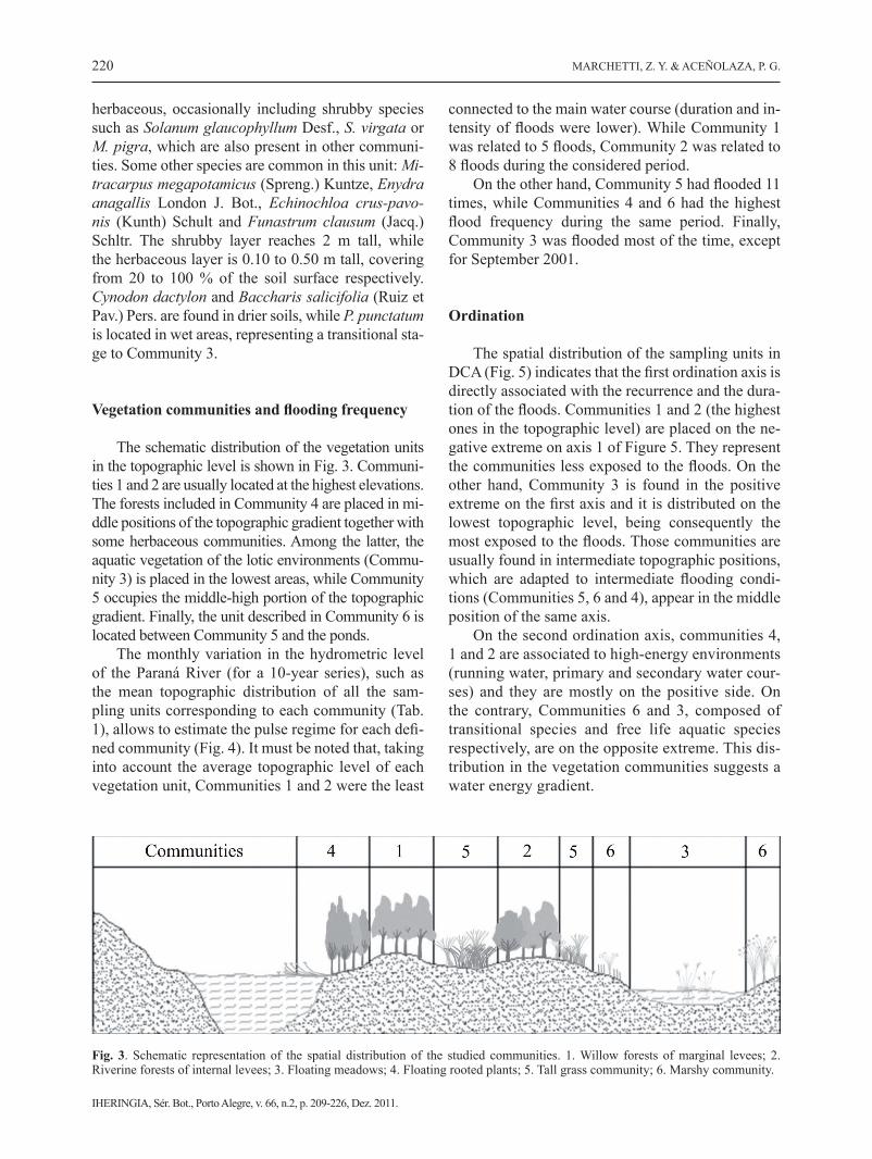
Vegetation communities and flooding frequency
The schematic distribution of the vegetation units in the topographic level is shown in Fig. 3. Communi-ties 1 and 2 are usually located at the highest elevations. The forests included in Community 4 are placed in mi-ddle positions of the topographic gradient together with some herbaceous communities. Among the latter, the aquatic vegetation of the lotic environments (Commu-nity 3) is placed in the lowest areas, while Community 5 occupies the middle-high portion of the topographic gradient. Finally, the unit described in Community 6 is located between Community 5 and the ponds.
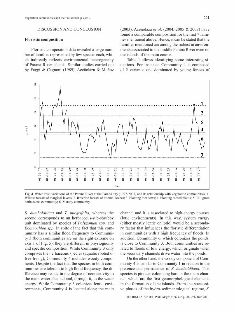
The monthly variation in the hydrometric level of the Paraná River (for a 10-year series), such as the mean topographic distribution of all the sam-pling units corresponding to each community (Tab. 1), allows to estimate the pulse regime for each defi-ned community (Fig. 4). It must be noted that, taking into account the average topographic level of each vegetation unit, Communities 1 and 2 were the least
connected to the main water course (duration and in-tensity of floods were lower). While Community 1 was related to 5 floods, Community 2 was related to 8 floods during the considered period.
On the other hand, Community 5 had flooded 11 times, while Communities 4 and 6 had the highest flood frequency during the same period. Finally, Community 3 was flooded most of the time, except for September 2001.
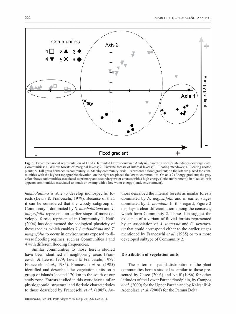
Ordination
The spatial distribution of the sampling units in DCA (Fig. 5) indicates that the first ordination axis is directly associated with the recurrence and the dura-tion of the floods. Communities 1 and 2 (the highest ones in the topographic level) are placed on the ne-gative extreme on axis 1 of Figure 5. They represent the communities less exposed to the floods. On the other hand, Community 3 is found in the positive extreme on the first axis and it is distributed on the lowest topographic level, being consequently the most exposed to the floods. Those communities are usually found in intermediate topographic positions, which are adapted to intermediate flooding condi-tions (Communities 5, 6 and 4), appear in the middle position of the same axis.
On the second ordination axis, communities 4, 1 and 2 are associated to high-energy environments (running water, primary and secondary water cour-ses) and they are mostly on the positive side. On the contrary, Communities 6 and 3, composed of transitional species and free life aquatic species respectively, are on the opposite extreme. This dis-tribution in the vegetation communities suggests a water energy gradient.
Fig. 3. Schematic representation of the spatial distribution of the studied communities. 1. Willow forests of marginal levees; 2. Riverine forests of internal levees; 3. Floating meadows; 4. Floating rooted plants; 5. Tall grass community; 6. Marshy community.
221
IHERINGIA, Sér. Bot., Porto Alegre, v. 66, n.2, p. 209-226, Dez. 2011.
Vegetation communities and their relationship with ...
DISCUSSION AND CONCLUSION
Floristic composition
Floristic composition data revealed a large num-ber of families represented by few species each, whi-ch indirectly reflects environmental heterogeneity of Parana River islands. Similar studies carried out by Faggi & Cagnoni (1989), Aceñolaza & Muñoz
(2003), Aceñolaza et al. (2004, 2005 & 2008) have found a comparable composition for the first 7 fami-lies mentioned above. Hence, it can be stated that the families mentioned are among the richest in environ-ments associated to the middle Paraná River even on the islands of the main course.
Table 1 allows identifying some interesting si-tuations. For instance, Community 4 is composed of 2 variants: one dominated by young forests of
S. humboldtiana and T. integrifolia, whereas the second corresponds to an herbaceous-sub-shrubby unit dominated by species of Polygonum spp. and Echinochloa spp. In spite of the fact that this com-munity has a similar flood frequency to Communi-ty 3 (both communities are on the right extreme on axis 1 of Fig. 5), they are different in physiognomy and specific composition. While Community 3 only comprises the herbaceous species (aquatic rooted or free-living), Community 4 includes woody compo-nents. Despite the fact that the species in both com-munities are tolerant to high flood frequency, the di-fference may reside in the degree of connectivity to the main water channel and, through it, to the water energy. While Community 3 colonizes lentic envi-ronments, Community 4 is located along the main
channel and it is associated to high-energy courses (lotic environments). In this way, system energy (either mostly lentic or lotic) would be a seconda-ry factor that influences the floristic differentiation in communities with a high frequency of floods. In addition, Community 6, which colonizes the ponds, is close to Community 3. Both communities are re-lated to floods of low energy, which originate when the secondary channels drive water into the ponds.
On the other hand, the woody component of Com-munity 4 is similar to Community 1 in relation to the presence and permanence of S. humboldtiana. This species is pioneer colonizing bars in the main chan-nel, which are the first geomorphological elements in the formation of the islands. From the successi-ve phases of the hydro-sedimentological regime, S.
Fig. 4. Water level variations of the Paraná River at the Paraná city (1997-2007) and its relationship with vegetation communities. 1. Willow forests of marginal levees; 2. Riverine forests of internal levees; 3. Floating meadows; 4. Floating rooted plants; 5. Tall grass herbaceous community; 6. Marshy community.
222
IHERINGIA, Sér. Bot., Porto Alegre, v. 66, n.2, p. 209-226, Dez. 2011.
MARCHETTI, Z. Y. & ACEÑOLAZA, P. G.
humboldtiana is able to develop monospecific fo-rests (Lewis & Franceschi, 1979). Because of that, it can be considered that the woody subgroup of Community 4 dominated by S. humboldtiana and T. integrifolia represents an earlier stage of more de-veloped forests represented in Community 1. Neiff (2004) has documented the ecological plasticity of these species, which enables S. humboldtiana and T. integrifolia to occur in environments exposed to di-verse flooding regimes, such as Communities 1 and 4 with different flooding frequencies.
Similar communities to those herein studied have been identified in neighboring areas (Fran-ceschi & Lewis, 1979; Lewis & Franceschi, 1979; Franceschi et al., 1985). Franceschi et al. (1985) identified and described the vegetation units on a group of islands located 120 km to the south of our study zone. Forests studied in this work have similar physiognomic, structural and floristic characteristics to those described by Franceschi et al. (1985). Au-
thors described the internal forests as insular forests dominated by N. angustifolia and in earlier stages dominated by A. inundata. In this regard, Figure 2 displays a clear differentiation among the censuses, which form Community 2. These data suggest the existence of a variant of fluvial forests represented by an association of A. inundata and C. urucura-na that could correspond either to the earlier stages mentioned by Franceschi et al. (1985) or to a more developed subtype of Community 2.
Distribution of vegetation units
The pattern of spatial distribution of the plant communities herein studied is similar to those pre-sented by Casco (2003) and Neiff (1986) for other latitudes of the Lower Parana floodplain, by Campos et al. (2000) for the Upper Parana and by Kalesnik & Aceñolaza et al. (2008) for the Parana Delta.
Fig. 5. Two-dimensional representation of DCA (Detrended Correspondence Analysis) based on species abundance-coverage data. Communities: 1. Willow forests of marginal levees; 2. Riverine forests of internal levees; 3. Floating meadows; 4. Floating rooted plants; 5. Tall grass herbaceous community; 6. Marshy community. Axis 1 represents a flood gradient; on the left are placed the com-munities with the highest topographic elevation; on the right are placed the lowest communities. On axis 2 (Energy gradient) the grey color shows communities associated to primary and secondary water courses with a high energy (lotic environment), in black color it appears communities associated to ponds or swamp with a low water energy (lentic environment).
223
IHERINGIA, Sér. Bot., Porto Alegre, v. 66, n.2, p. 209-226, Dez. 2011.
Vegetation communities and their relationship with ...
Soares & Perez Filho (1997) mentioned that en-vironmental diversity of large rivers is related to the physical and chemical variation of the sediments. Apart from that, the interaction between the topogra-phy and the hydrological regime has an impact on di-versity. Indirectly, the differences in the topographic position regulate the influence of pulse regime on plant communities; either enhancing or reducing the water energy caused by high or low river water levels.
Other studies carried out in southeastern Brazil in order to test the relationship between riparian fo-rest diversity and channel width, have found that the main variation was caused by the river hydrological phases (Metzger et al., 1997). These authors point out that the vegetation units more affected by floods had the lowest diversity and evenness values. In this work, the mentioned situation corresponds to the forests of Community 4, which has low richness and diversity values. On the other hand, riverine forests of internal levees (Community 2) are less flooded and they cons-titute the most complex and diverse formation of the fluvial environments. Willow forests of marginal le-vees share the same topographic elevation as riverine forests of internal levees, but the first ones are simple in their structure, less diverse and with important di-fferences in their specific composition. The mentioned differences between forests related to similar flood in-tensities (e.g. Communities 1 and 2) suggest that, apart from the flood frequency, other factors are regulating the characteristics of the vegetation communities. A possible hypothesis may be inferred from the analysis of the second axis in Figure 5, where communities with similar flood frequencies are opposites. Community 4 (on the positive side of the axis) colonizes lotic envi-ronments, while communities 3 and 6 (on the negative side) correspond to vegetation associated with lentic water bodies. It must be assumed that a second varia-ble, presumably water energy, could cause these diffe-rences. In the internal and lowest topographic positions of the island, species respond to a different rate of water vertical movement, which is not necessarily related to the hydrometric height of the river. During the low wa-ter phase and due to the reduction of water bodies the vegetation associated with lentic water (Community 3) can survive only in the deepest ponds. During these periods with low water level, tall grasslands and herb species (Community 5) partially colonize these low sites, creating a particular specific composition (Com-munity 6). During these fast colonization and regres-sion processes, the communities become fragmented in patches, which will be in accordance with the micro topographic conditions.
It can be concluded that micro topographic diffe-rences (which establish the relationship between the vegetation and the pulse regime) and the water energy (determined by the connectivity degree with the main water channel) could be the most important factors in determining the composition and distribution of the vegetation in the environments of the middle Paraná. Nevertheless, the differences in richness and structure of the forests could not be explained from these fac-tors. Despite the fact that they are distributed at the same topographic level they have strong differences in richness and structure. Other factors like the ge-omorphological dynamics, succession, the quality of sediments and groundwater should be taken into ac-count to explain the characteristics and distribution of fluvial forests in the Paraná River floodplain.
ACKNOWLEDGEMENTS
This work was made possible by a research grant from the Consejo Nacional de Investigaciones Cien-tíficas y Técnicas. We thank the local residents, Da-rio Mayr, Lito Franco, Carlos Girard, Tony Cramaro and people who helped during the fieldwork, espe-cially to Raúl D´Angelo.
REFERENCES
Aceñolaza, P.G., Manzano, A., Rodriguez, E., Sánchez, L., Ron-chi Virgolini, A.L., Giménez, E., Demonte, D. & Marchetti, Z.Y. 2008. Biodiversidad de la región superior del complejo deltaico del Río Paraná. In Temas de la Biodiversidad del Litoral III (F. Aceñolaza, ed.). Magna, San Miguel de Tucu-mán, v. 17, p.127-152.
Aceñolaza, P.G., Sione, W., Kalesnik, F. & Serefini M.C. 2005. Determinación de unidades homogéneas de vegetación en el Parque Nacional Pre-Delta (Argentina). In Temas de la Biodiversidad del Litoral II (F. Aceñolaza, ed.). Magna, San Miguel de Tucumán, v. 14, p.81-90.
Aceñolaza, P.G., Povedano, H., Manzano, A., Muñoz, J. de D., Areta, J. & Ronchi Virgolini, A.L. 2004. Biodiversidad del Parque Nacional Pre Delta. In Temas de la Biodiversidad del Litoral (F. Aceñolaza, ed). Magna, San Miguel de Tucu-mán, v. 12., p.169-184.
Aceñolaza, P.G. & Muñoz J. de D. 2003. Flora del Parque Na-cional Pre-Delta (Entre Ríos, Argentina). Boletin de la So-ciedad Argentina de Botáncia. Intituo Multidisciplinario de Biología Vegetal, Córdoba, 38: 219.
224
IHERINGIA, Sér. Bot., Porto Alegre, v. 66, n.2, p. 209-226, Dez. 2011.
MARCHETTI, Z. Y. & ACEÑOLAZA, P. G.
Bournette, G., Amoros, C. & Lamouroux, N. 1998. Aquatic plant diversity in riverine wetlands: the role of connectivi-ty. Fresh Water Biology, 39: 267-283.
Budke, J.C. & Jarenkow, J.A. 2007. Relationships between tree component structure, topography and soils of a riverside forest, Río Botucaraí, Southern Brazil. Plant Ecology, 189:187-200.
Campos, J.B. & De Souza, M.C. 2002. Arboreous Vegetation of an Alluvial Riparian Forest and their soil relations: Por-to Rico Island, Paraná River, Brasil. Brazilian Archives of Biology and Technology, 45 (2):137-149.
Campos, J.B., Romagnolo, M. & De Souza, M.C. 2000. Struc-ture, composition and spatial distribution of tree species in a remnant of the semideciduous seasonal alluvial forest of the Upper Paraná river Floodplain. Brazilian Archieves of Biology and Technology, 43 (2):185-194.
Carvalho, D.A., Olivera Filho, A.T., Vilela, E.A., Curi, N., Van Den Berg G, E., Fontes, M.A.L. & Botezeññi, L. 2005. Distribuição das espécies arbóreo-arbustivas ao longo de um gradiente de topografia sozinho e em um trecho de mata ciliar do Rio São Francisco em Três Marias. MG, Brasil. Revista Brasileira de Botânica, 28 (2):329-345.
Casco, S.L., Basterra De Chiozzi, I. & Neiff, J.J. 2005. La vege-tación como indicador de la Geomorfología Fluvial. Revis-ta Brasilera de Geomorfología, 1:123-136.
Casco, S.L. 2003. Distribución de la vegetación fluvial y su re-lación con el régimen de pulsos en el bajo Paraná. In Temas de la Biodiversidad del Litoral (F. Aceñolaza, ed) Magna, San Miguel de Tucumán, v.12, p.5-12.
Chang-Seok, L., Yong-Chan, C., Hyun-Cheol, S. & Sung-Ae, P. 2009. Differences between sand and gravel bars of streams in patterns of vegetal succession. Journal of Ecology and field biology, 32(1):55-60.
Cheng, Y. & Nakamura, T. 2006. Phytosociological study on steppe vegetation in the vicinity of Kharkiv, Ukraine. Gras-sland Science, 52:61-71.
Chytrý, M. & Otýpkivá, Z. 2003. Plot size used for phytosocio-logical sampling of European vegetation. Journal of Vege-tation Science, 14:563-570.
Decocq, G. 2002. Patterns of plant species and community di-versity at different organization levels in a forested riparian landscape. Journal of Vegetation Science, 13:91-106.
Drago, E. 1981. Grados de conexión y fases hidrológicas en am-bientes leníticos de la llanura aluvial del Río Paraná (Ar-gentina). Ecología Argentina, 6:27-33.
Faggi, A.M. & Cagnoni, M. 1989. Flora del Parque Natural Cos-tanera Sur. Parodiana, 6: 49-66.
Finlayson, C.M. 2005. Plant Ecology of Australia´s Tropical Floo-dplain Wetlands: A Review. Annals of Botany, 96:541-555.
Franceschi, E.A. & Lewis, J.P. 1979. Notas sobre la vegetación del valle santafecino del Río Paraná (R. Argentina). Ecosur, 6:55-82.
Franceschi, E.A., Prado, D.E. & Lewis J.P. 1985. Comunidades vegetales y mapa de vegetación de la Reserva “El Rico” e islas aledañas, Provincia de Santa Fe, Argentina. Universi-dad Nacional de Rosario, Santa Fe. 40 p.
Franceschi, E.A., Torres, P.S., Prado, D.E. & Lewis J.P. 2000. Disturbance, succession and stability: Ten year study of temporal variation of species composition after a catastro-phic flood en the river Paraná, Argentina. Community Eco-logy, 1(2):205-214.
Häedtle, W., Redecker, B., Assmann, T. & Meyer, H. 2006. Ve-getation responses to environmental conditions in flood-plain grasslands: Prerequisites for preserving plant species diversity. Basic and Applied Ecology, 7 (3):280-288.
Heung-Lak, C.H. & Hong, S.K. 2006. Distribution patterns, floristic differentiation and succession of Pinus densiflora forest in South Korea: A perspective at nation-wide scale. Phytocoenologia, 36 (2):213-229.
Isermann, M. 2008. Classification and habitat characteristics of plant communities invaded by the non-native Rosa rugosa Thunb, in NW Europe. Phytocoenologia, 38 (1-2):133-150.
Kalesnik, F. & Aceñolaza, P.G. 2008. Regional distribution of native and exotic species in levees of the lower delta of the Paraná River. Acta Scientiarum. Biological Sciences, 30 (4):391-402.
Kandus, P., Malvarez, A.I. & Madanes, N. 2003. Estudio de las comunidades de plantas herbáceas de las islas bonaerenses del bajo delta del Río Paraná (Argentina). Darwiniana, 41 (1-4):1-16.
Koutcky, P. & Prach, K. 2005. Recovery of alluvial meadows alter an extreme summer flood: a case study. Ecohydrology and Hydrology, 5 (1):33-39.
Lewis, J.P. & Franceschi, E.A. 1979. Notas sobre la dinámica de la vegetación del Valle del Río Paraná. Ecosur, 6:145-163.
Marchetti, Z.Y. & Aceñolaza P.G. 2005. Detección satelital y descripción de patrones de vegetación en islas del Para-ná Medio. In Temas de la Biodiversidad del Litoral II (F. Aceñolaza, ed). Magna, San Miguel de Tucumán, v.14, p.151-158.
Martins, S.V., Rodriguez Brito, E., Teixeira De Oliveira Filho, A., Da Silva, A.F. & Silva. E. 2008. Floristic composition of two wetland forest in Araguaian plain, state of Rocan-
225
IHERINGIA, Sér. Bot., Porto Alegre, v. 66, n.2, p. 209-226, Dez. 2011.
Vegetation communities and their relationship with ...
tins, Brasil, and comparison with other areas. Árvore, 1:129-141.
Mc Cune, B. & Mefford, M.J. 1999. PC-ORD Multivariate analy-sis of ecological data. MjM Software Design, USA. 237 p.
Metzger, J.P., Bernacci, L.C. & Goldenberg, R. 1997. Pattern of tree species diversity in riparian forest fragments of diffe-rent widths (SE Brasil). Plant Ecology, 133:135-152.
Muller-Dombois, D. & Ellemberg H. 1974. Aims and methods of vegetation ecology. John Willey and Sons, New York. 547 p.
Neiff, J.J. 1979. Fluctuaciones de la vegetación acuática en lagu-nas del valle del río Paraná en la transección Paraná-Santa Fe, entre 1970 y 1977. Physis, 38 (95):41-53.
Neiff, J.J. 1986. Las grandes unidades de vegetación y ambiente insular del río Paraná en el tramo Candelaria-Itá Ibaté. Re-vista de Ciencias Naturales del Litoral, 17 (1):7-30.
Neiff, J.J. 1990. Ideas para la interpretación ecológica del Para-ná. Interciencia, 15 (6):424-441.
Neiff, J.J. 1996. Large rivers of South America: toward the new approach. Verhandlungen des Internationalen Verein Lim-nologie, 26:167-180.
Neiff, J.J. 1997. El régimen de pulsos en ríos y grandes hume-dales de Sudamérica, pp 99-149. En: Tópicos sobre gran-des humedales sudamericanos. Malvárez, A.I. y P. Kandus (eds.), Orcyt-Mab (Unesco), Montevideo, Uruguay. 106 p.
Neiff, J.J. 2004. Bosques fluviales de la cuenca del Paraná. In Ecología & Manejo de los bosques de Argentina (M.F. Ar-turi, J.L. Frangi & J.F. Goya, eds.). Editorial de la Universi-dad Nacional de La Plata, Argentina, p. 1-26.
Neiff, J.J, Patiño C.A.E. & Casco, S.L. 2006. Atenuación de las crecidas por los humedales del Bajo Paraguay. In Hume-dales fluviales de América del Sur. Hacia un manejo sus-tentable (J. Capatto & J. Petean, eds.). Proteger Ediciones, Argentina, p. 261-276.
Oakley, L.J., Prado D.E. & Adamoli, J. 2005. Aspectos bioge-ográficos del Corredor Fluvial Paraguay-Paraná. In Temas de la Biodiversidad del Litoral II (F. Aceñolaza, ed). Mag-na, San Miguel de Tucumán, v. 14, p. 245-258.
Panitsa, M. & Tzanoudakis, D. 2001. A floristic investigation of the islet groups Arki and Lipsi (East Aegean Area, Greece). Folia Geobotanica, 36:265-279.
Ramonell, C.G., Amsler, M. & Toniolo, H. 2000. Geomorfolo-gía del cauce principal. In El río Paraná en su tramo medio. Contribución al conocimiento y prácticas ingenieriles en un gran río de llanura. Tomo 1 (C. Paoli & M. Shreider, eds).
Centro de Publicaciones de la Universidad. Nacional del Litoral, Argentina, p.175-229
Rojas, A.E. & Saluso, J.H. 1987. Informe Climático de la Provin-cia de Entre Ríos. Publicación técnica nº 14 de Instituto Na-cional de tecnología Agropecuaria (INTA), Argentina. 20 p.
Sarr, D.A. & Hibbs, D.E. 2007. Woody riparian plant distribu-tions in western Oregon, USA: comparing lanscape and lo-cal factors. Plant Ecology, 190:291-311.
Sione, W., Aceñolaza, P.G., Zamboni, L., Serafini, C., Del Val-le, H. & Gallardo Lancho, J. 2009. Aplicaciones de la te-ledetección en la estimación de las emisiones de CO2 por quemas de áreas insulares en el Complejo Litoral del Río Paraná (Argentina). In Emisiones de gases con efecto in-vernadero en ecosistemas Iberoamericanos. Salamanca, España. Sociedad Iberoamericana de Física y Química Am-biental (J. Campos & M. Conti, eds.) SiFyQA, Salamanca, España, p. 255-272
Soares, P.R.B. & Perez Filho, A. 1997. Recomposição de mata ciliar em planície de inundação- Proposta metodológica. In Anais do III Simpósio nacional de recuperação de áreas de-gradadas (Trabalhos Voluntários). Universidade Federal de Viçosa, Viçosa, p. 14-26.
Stoll, A., Sepúlveda, C. & San Martin, J. 2006. Patrón florístico-es-tructural de la vegetación nativa remanente en el límite norte del Bosque Templado Costero de Chile: el caso de la quebrada Cayurranquil (VII Región, Chile). Bosque, 27:64-71.
Van Coller, A.L., Rogers, K.H. & Heritage, G.L. 2000. Riparian vegetation-environment relationships: complimentarity of gradients versus patch hierarchy approaches. Journal of Vegetation Science, 11:337-350.
Ward, J.V., Tockner K. & Schiemer, F. 1999. Biodiversity of floodplain river ecosystems: ecotones and connectivity. Regulated Rivers: Research and Management, 15:125-139.
Zuloaga, F.O. & Morrone O. 1996. Pteridophyta, Gymnosper-mae y Angiospermae (Monocotyledoneae). In Catálogo de las Plantas Vasculares de la República Argentina I. (F.O. Zuloaga & O. Morrone, eds.). Missouri Botanical Garden Press, St. Louis. 323 p.
Zuloaga, F.O. & Morrone, O. 1999. Angiospermae (Dicotyledo-neae). In Catálogo de las Plantas Vasculares de la República Argentina II (F.O. Zuloaga & O. Morrone, eds). Missouri Botanical Garden Press, St. Louis. 1269 p.
Zuloaga, F.O., Nicora, E.G., Rúgolo de Agrasar, Z.E., Morrone, O., Pensiero, J. & Cialdella, A.M. 1994. Catálogo de la Fa-milia Poaceae en la República Argentina. Missouri Botanical Garden, St. Louis. 178 p.