Embed Size (px)
Citation preview
Schools, Land Markets and Spatial Effects
Guanpeng Donga,1, Wenjie Wub,1,2
a. Department of Geography and Planning, The University of Liverpool, Liverpool, L69 3BX, UK
b. Heriot-Watt University, Edinburgh, EH14 4AS, UK.
Abstract:
This paper uses a spatial modeling approach to explore the capitalisation effect of proximity to schools on land markets. The results suggest that adjacency to primary schools leads to considerable price premiums but there are no significant effects on middle schools and universities. The results also provide some reassurance that spatial simulations offer a useful representation of localised variations in values attached to proximity to schools in Beijing, China.
Keywords: Land market; School valuation; Spatial econometrics
1 Authors are listed in alphabetical order.2 Corresponding author. Email: [email protected]
1

1. Introduction
China has experienced substantial land and housing marketisation in the past decade
(Liang et al., 2007; Cheshire, 2007; Zheng and Kahn, 2008). This transformation has
come alongside massive local public infrastructure investments, booming real estate
investments (Zheng and Kahn, 2013). Such rapid but differential spatial expansion in
infrastructure and real estate markets will transform the determinants of property
prices within cities. In Chinese cities, especially large cities such as Beijing and
Shanghai, educational resources are scarce and distributed non-uniformly across
space, and thus how school facilities are capitalised into land values have drawn
increasing attention of households, policy makers and planners.
As an important source of urban externalities, recent studies have shown that
proximity to schools can influence property price premiums and parents’ housing
location choice (e.g. Cheshire and Sheppard, 2004; Gibbons and Machin, 2008;
Cellini et al., 2010; Gibbons et al., 2013). For example, whilst living near a primary
school or middle school may result in commuting time savings for parents and their
children, there might also be traffic congestions and noise associated with schools.
While mayors in China want to balance the optimal distribution of educational
facilities for their cities to achieving an equalisation of educational resources, an
important but untested question to optimal education resource allocations is a solid
understanding of how the capitalisation effect of proximity to schools varies with the
2
persistence of spatial dependence effects in a land market. This is an important issue
because ignoring or mis-specifying spatial dependence in a hedonic land price model
is likely to result in biased and inconsistent estimates of the amenity value of
proximity to schools (e.g. Brasington and Haurin, 2006).
This paper aims to shed lights on these questions by looking at the distributional
effects of proximity to schools on Beijing’s residential land market, by capturing the
hierarchical structure underlying the land price data. We improve on the traditional
spatial econometric evaluation of proximity to schools by simultaneously modelling
two types of unobservables via a Bayesian hierarchical spatial autoregressive model
developed in Dong and Harris (2015). More specifically, the property level
unobservable effect is modelled by the inclusion of a spatially lagged land price
variable as in Brasington and Haurin (2006). The neighbourhood level unobservable
impact is modelled as a spatial autoregressive process (see detailed discussions in
Section 4). The former corresponds to a horizontal spatial dependence effect—an
effect arising from the geographical proximity amongst properties while the latter
corresponds to a vertical dependence effect—a top-down effect induced by
neighbourhoods (unobservable characteristics such as neighbourhood prestige) upon
properties (Dong and Harris, 2015; Dong et al. 2015).
The rest of this paper is organized as follows. Section 2 highlights the limitations
of previous studies on the economic valuation of schools. Section 3 describes our
econometric models, followed by a summary of the institutional context and data in
Section 4. Section 5 presents the results. In the final section, we draw conclusions.
3
2. Limitations of previous research
Most existing research evaluating the captialisation effects of schools assesses their
effects on property values and residential sorting patterns. Typically, these studies
compare house prices across school catchment zones and boundaries. The empirical
results vary across studies. In this section, we highlight some limitations of the
existing methodologies on which we try to improve in the present study.
Suppose that we build a statistical model of land price determinants using data
where land parcels are nested into neighbourhoods (e.g. census units such as lower
layer super output areas in England). A complete model specification would be the
one that relates land prices to all land parcel and neighbourhood characteristics.
However, not all of the variables are observable or quantitatively measureable and the
unobservable part will be embedded into the hedonic equation as a compound model
error term. It is reasonable to decompose the unobservable factors to the land parcel
level effect denoted as v (e.g. the presence of a hazardous landfill near a land parcel)
and the neighbourhood level effect denoted as θ (e.g. neighbourhood physical and
cultural characteristics or prestige). Under this context, if these unobservable factors
(either v or θ or both) are varying systematically across space and correlate with the
school variables of interest, the hedonic model residuals will be spatial dependent and
the estimates of the school captalisation effect will be biased by using a traditional
ordinal least square estimation strategy.
An innovative identification strategy to control for the unobservable factors is
4

the application of boundary fixed effect (or spatial discontinuity) approach (e.g.
Black, 1999; Gibbons et al., 2013). In essence, this approach compares house values
on the opposite sides of school attendance zone (or catchment area) boundaries in a
school district and estimates the value of school quality as differences of the adjusted
house prices—controlling for other house characteristics and boundary dummy
variables. The key assumption of this approach is that all neighbourhood variables
other than school quality remain the same when crossing borders, thus a boundary
fixed effect approach can capture both the observed and unobservable neighbourhood
characteristics, leaving the property price differentials solely attributable to
differences in school quality. While the approach is intuitively straightforward and
logically sound, it is not without its problems. For example, neighbourhood
characteristics do vary near school attendance zone borders due to a household sorting
process (e.g. Brasington and Haurin, 2006; Bayer et al., 2007). If people with high
educational status had a stronger preference for schools with high quality than those
with low educational status, differences in the neighbourhood-level educational status
would exist. This however cannot be effectively controlled by the boundary fixed
effect approach.
Brasington and Haurin (2006) proposed to use the spatial econometric approach
to tackle the issue of omitted variable bias facing studies of school evaluation. The
basic idea is to directly model the unobservable influences (the sum of v and θ) by
adding a spatially lagged dependent variable (house price in this context) into the
traditional hedonic price model. The lagged house price variable (constructed through
5
a spatial weights matrix that specifies the connection structure among properties)
captures the unobservable influences on house prices and the spatial dependence of
them. Technical details of the spatial econometric approach are provided in Anselin
(1988) and LeSage and Pace (2009), among others. The spatial dependence in the
unobservables is intuitively plausible as the unobservable influences might be similar
for properties that are in close geographical proximities (e.g. Brasington and Hite,
2005; Brasington and Haurin, 2006; Wen et al., 2014; Anselin et al., 2010; Lazrak et
al., 2014; Leonard et al., 2015).
But a potential problem associated with this econometric approach is the
conflation of unobservable influences at the neighbourhood and property levels. It is
important to distinguish between the two types of unobservables u and θ as they might
represent different spatial processes—one operating at a property scale and another at
a neighbourhood scale. In the methodological term, failing to separate the two sets of
unobserved effects could lead to biased estimates of the spatial dependence effect (i.e.
the coefficient of the lagged price variable). To explicitly address this concern, we
recognise two types of spatial dependence effects in the estimation process. By
constructing precisely geo-coded location information and combining this information
with GIS maps, we can measure land parcel locations, proximity to school facilities,
and other characteristics of local public goods in the spatial context.
6
3. Econometric models
Following the hedonic price modelling literature, land price is related to a series of
locational and neighbourhood characteristic variables, as shown in Equation (1):
LnPriceij=a+β School 'ij+φ Lij' +δ Z j
' +θ j+εij (1)
where the dependent variable (LnPriceij) is the natural logarithm of the price for a
residential land parcel i in neighborhood j. The school variables under investigation
are in vectors Schoolij, which include proximity to primary and middle schools, and to
prestige universities. The quality of nearest primary and middle schools of each land
parcel are also included. Lij represents locational and structural variables of each land
parcel while Zij includes neighbourhood level variables. β, δ and φ are vectors of
regression coefficients to estimate. The vector θj are unobserved neighbourhood
effects and εij are random innovations, following as an independent normal
distribution with mean of zero and variance of σe2.
An important issue with the standard hedonic model specification is that the
horizontal spatial dependence effect of land prices is not captured. A common practice
would be incorporating fixed spatial effects in the hedonic price model (θj treated as
fixed in Equation (1)). It implicitly assumes that dependence in land prices is raised
by the neighbourhood level unobservables. This is a fairly strict assumption for real-
world land price data as dependence in land prices could also arise from the land
parcel level unobservables and spillover effects from one land parcel upon
7
surrounding land parcels and vice versa. By adopting a fixed effect estimation
strategy, effects of neighbourhood level variables can no longer be estimated. To
address this concern, a typical spatial hedonic price model is usually adopted
(Brasington and Haurin, 2006; Anselin et al., 2010),
LnPrice ij=a+ ρ wi LnPrice+β School 'ij+φ Lij' +δ Z j
' +εij (2)
where wi is a vector of spatial weights, measuring the how closely other observations
are related to the ith observation. Spatial weights are calculated either by using an
inverse distance scheme with a pre-defined threshold distance or based on
geographical contiguity (Cliff and Ord, 1981; Anselin, 1988). Multiplying wi by the
price vector gives a weighted average price of the neighbours of i if, as is usually the
case, wi is normalised so that the sum of its elements equal to 1. Equation (2) allows
for an explicit test of whether land price at location i is related to land prices at
locations to which i is connected to (significance of the spatial autoregressive
parameter ρ), which is a standard simultaneous autoregressive model (SAR) in the
spatial econometrics literature.
One potential problem that has not been dealt with by using SAR is the
vertical spatial dependence effect in land prices arising from the neighbourhood
unobservables. Land parcels in the same neighbourhood are exposed to identical
neighbourhood characteristics (Z) and unobservables (θ). Thus land prices in the same
neighbourhood tend to be more similar than land prices across different
neighbourhoods (Jones, 1991; Orford, 2000). This vertical type of spatial dependence
can be accommodated in a multilevel hedonic price model, which is expressed as,
8
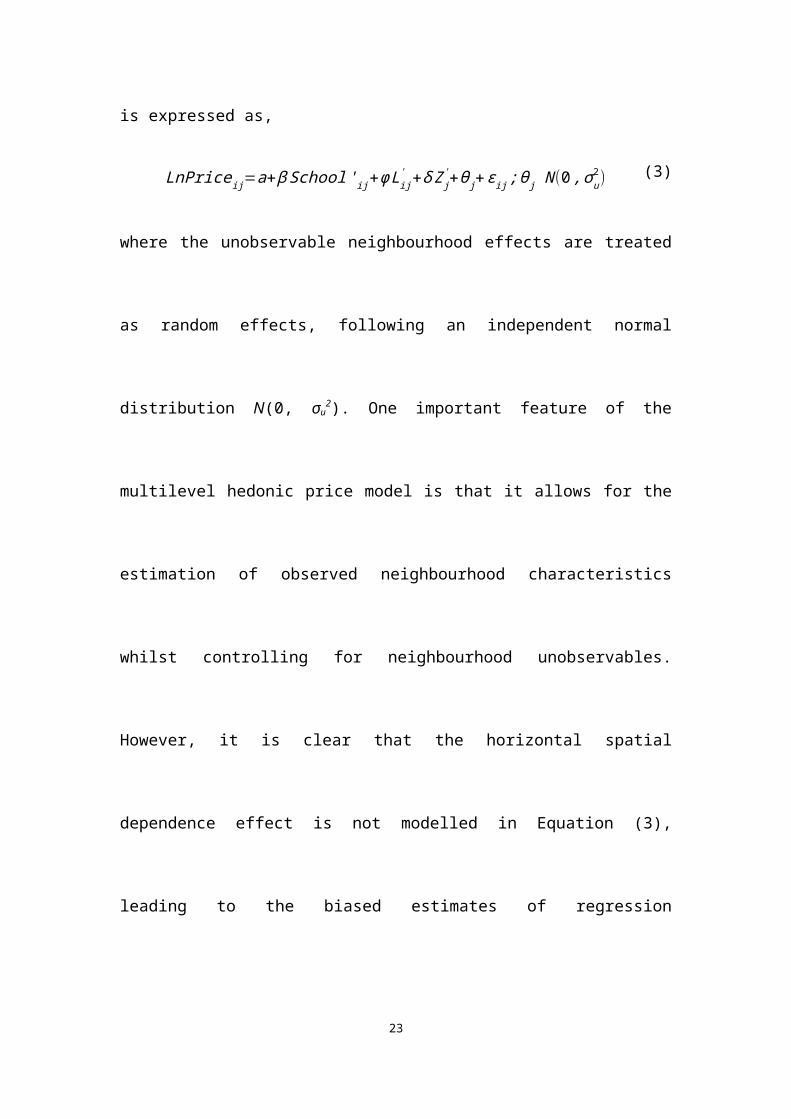
LnPriceij=a+β School 'ij+φ Lij' +δ Z j
' +θ j+εij ;θ j N (0 , σu2) (3)
where the unobservable neighbourhood effects are treated as random effects,
following an independent normal distribution N(0, σu2). One important feature of the
multilevel hedonic price model is that it allows for the estimation of observed
neighbourhood characteristics whilst controlling for neighbourhood unobservables.
However, it is clear that the horizontal spatial dependence effect is not modelled in
Equation (3), leading to the biased estimates of regression coefficients (Anselin,
1988).
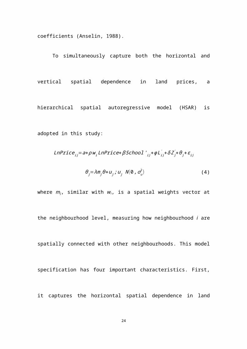
To simultaneously capture both the horizontal and vertical spatial dependence
in land prices, a hierarchical spatial autoregressive model (HSAR) is adopted in this
study:
LnPriceij=a+ ρ wi LnPrice+β School 'ij+φ Lij' +δ Z j
' +θ j+εij
θ j=λm j θ+u j;u j N (0 , σu2) (4)
where mj, similar with wi, is a spatial weights vector at the neighbourhood level,
measuring how neighbourhood i are spatially connected with other neighbourhoods.
This model specification has four important characteristics. First, it captures the
horizontal spatial dependence in land prices through the term wiLnPrice and the
vertical spatial dependence through the inclusion of unobservable neighbourhood
effects (θ). Secondly, neighbourhood unobservables are not treated as purely random
innovations as in a multilevel hedonic price model. Instead, possible spatial
dependence effect in neighbourhood unobservables is also modelled. Lastly, spatial
9
autoregressive parameters at both the land parcel and neighbourhood levels (ρ and λ)
are estimated, and therefore we are able to capture the difference in intensity of spatial
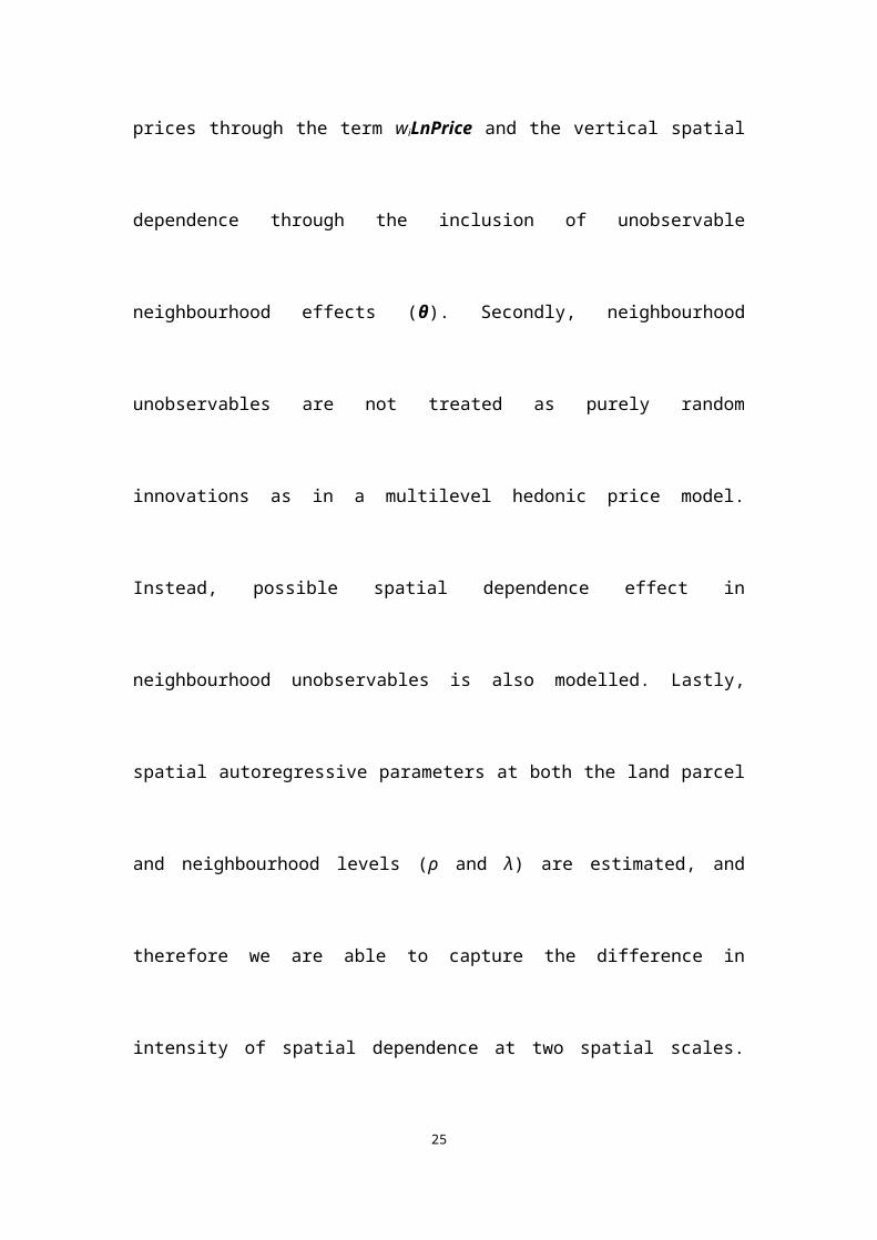
dependence at two spatial scales. Failing to model one of them might lead to
inaccurate estimation of another (Dong et al., 2015). For instance, ignoring (positive)
horizontal spatial dependence, multilevel hedonic models tend to overestimate the
vertical dependence effect (overestimated σu2). When not controlling for the vertical
dependence effect, SAR models tend to overstate the intensity of the horizontal spatial
dependence (overestimated ρ).
The spatial weights matrix at the land parcel level is calculated by using a
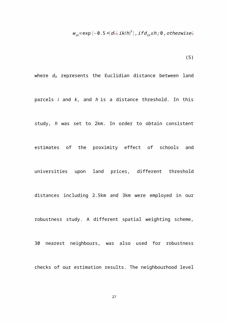
Gaussian kernel function with a distance threshold of h, as in Equation (5),
w ik=exp {−0.5 ×(d¿¿ ik /h)2 }, if d ik ≤ h ;0 , otherwise ¿ (5)
where dik represents the Euclidian distance between land parcels i and k, and h is a
distance threshold. In this study, h was set to 2km. In order to obtain consistent
estimates of the proximity effect of schools and universities upon land prices,
different threshold distances including 2.5km and 3km were employed in our
robustness study. A different spatial weighting scheme, 30 nearest neighbours, was
also used for robustness checks of our estimation results. The neighbourhood level
spatial weight matrix is measured by using the contiguity of districts. Following the
spatial econometric modelling convention, two spatial weights matrices are row-
normalized.
10
4. Research context and data
Since the late 1980s, most socialist countries have experienced dramatic socio-
economic transitions from a central planned economy system to a market-oriented
economy system. Compared with the complete and shock transitions in eastern
European countries, the market-oriented transition in China is in a gradual
environment (Nee, 1992). As one fundamental part of this transition, urban land
reform was first launched in 1987 by the initial practical experiment of land contract
leasing in the city of Shenzhen—the first special economic zone in China (Jingjitequ).
Since then, most Chinese cities have experienced dramatic transformation of its land
use system from free allocation toward a leasehold system as the government
reinstated the land from a social welfare good to a market commodity.
The context we seek to describe is the urban area of Beijing, one that has
experienced dramatic changes in growth and structure over the past two decades. To
better understand our datasets, we begin with a brief overview of Beijing and the
definition of neighborhood in this study. The metropolitan area of Beijing is divided
into several mega-districts, in which six of them are central city districts (Dongcheng,
Xicheng, Chaoyang, Haidian, Fengtai, Shijingshan), and others are generally
suburban or rural districts. Each mega-district is comprised by a number of
neighborhoods (Jiedao). Similar as the term of “zone (No.1 to No.6)” in London,
Beijing government and previous research have often used the term “ring roads (No.2
11
to No.6)”—which circled around the CBD2 to every direction, to define the urban
areas of Beijing. We followed this convention to define our study area. A Jiedao can
be linked to a census block in the sense that it is the primary unit for the organization
of the census in urban Beijing, which is defined as neighborhood in the present study.
The primary dataset of this study is the residential land parcel data, collected
from the Beijing Land Resources Bureau (BLRB). We have geo-coded all of the 1,210
undeveloped residential land parcels leased to real estate developers during 2003 and
2009. Dropping land parcels without price information, our final sample size is 1,077.
Fixed period effects (e.g. external shocks that influence prices of all land parcels)
were controlled by year dummy variables.3 Figure 1 shows the spatial distribution of
residential land parcels and land price variations across space.
[Figure 1 about here]
With respect to the school data, we have collected all 652 primary schools, 166
middle schools and 23 prestige universities in Beijing’s main urbanized areas.4 The
school distribution in China is largely exogenous to the current economic conditions
since most of schools have been built in the central-planned economy era. Like the
UK and other developed countries, Chinese city governments often implement a
devolved school policy to allocate eligible school-age children to schools based on the
2 The CBD in Beijing is located in the east direction of the TianAnMen Square, called “Guomao,” with a cluster of high-rise office buildings and many international companies’ headquarters.3 We also test whether there is temporal autocorrelation in land prices using the regression coefficients of year dummy variables from a linear regression model. The result from a first-order autoregressive model shows no evidence of statistically significant temporal autocorrelation in the temporal trend of land prices during the study period.4 The number of primary and middle schools are acquired from the website of Beijing Municipal Commission of Education. Our definition of middle school encompasses both middle schools and high schools. Prestige universities were defined as universities that are listed in either the “211 project” or the “985 project” organised by the central education administration of China. These universities receive much more academic and financial support from the central and municipal governments and usually recruit talented undergraduate and postgraduate students in China.
12
school catchment areas they belong to (especially for primary schools, see Zheng et
al., 2015). In general, local primary schools are scarce and have much difference in
school quality across neighborhoods in the urban area of Beijing. Households often
attach great importance to the primary school quality due to its direct relationship
with whether their kids can easily get admission to a better middle school. However,
the school quality information (e.g. standard exam scores or spending per student) are
not publicly accessible. Following Zheng et al. (2015), we use whether a primary
school is a “Key Primary School (KPS)” as a proxy for school quality. These KPS
schools were mostly founded in the 1950s by the Beijing Municipal Government.
They received much more capital and human resource investment (e.g. modern
teaching equipment and high-quality teachers) from the government than other
primary schools. With the implementation of the school catchment area policy,
significant price premiums have been found for houses within the attendance zones of
these KPS compared to those located in attendance zones of other primary schools
(Zheng et al., 2015).
But whether primary school quality is capitalised into prices of land parcels is
rather unclear. First, residential land parcels were not assigned to any specific school
attendance zones when they were leased to real estate developers. The geographical
proximity of a land parcel to KPS can, at best, increases its chance of being attaching
to the attendance zone of a particular KPS. A further concern is that a land parcel
usually consists of several residential complexes, and these complexes could belong
to different attendance zones of primary schools. We acknowledge that we are not
13
able to test for this conjecture. This study uses whether a middle school is rated as
Experimental Model Schools (EMS) as a proxy for the middle school quality.
Experimental Model Schools are created by the Beijing Municipal Government
mainly based on the formerly key middle schools. Given the policy adjustment of
school catchment boundaries in Beijing, it is difficult to apply for the standard school
catchment zone-based identification strategy to estimate the effects of schools on land
values at particular locations without a careful consideration of spatial dependence
effects.
Finally, we have calculated important locational variables that have been found to
be significantly associated with land prices. For example, the proximity to railway
stations is important in influencing the real property values (Bowes and Ihlanfeldt,
2001; Gibbons and Machin, 2005; Liang et al., 2007). From the Beijing Municipal
Bureau of Transportation (BMBT), we have acquired the list of Beijing’s well-
constructed railway stations before 2003 and calculated distances to the nearest
railway station for each land parcel. The proximity to the CBD, nearest green parks,
rivers and express roads are also included in our analysis. As suggested by recent
studies, any residential sorting arising from neighborhood socio-demographic
characteristics will bias the estimates of school values. At the district level (district
boundaries in Figure 1), we use the employment and population census data to control
for the potential influence of neighbourhood socio-demographic characteristics on
residential land values. The employment census data is collected from the 2nd City
Employment Census conducted in 2001 by the National Bureau of Statistics of China
14
(NBSC). Our population census data is collected from the City Population Census
reported by the National Bureau of Statistics of China (NBSC) in 2000. It includes
information on social components of each district such as the median education
attainment (Education attainment), the proportion of people renting public housing
(Public house renting) and the proportion of buildings built before 1949 (Age of
buildings). The indicator of public safety level is measured by the crime rates of the
neighborhood (Crime), which is calculated as the number of reported serious crimes
(murder, rape, robbery and property crimes including arson, burglary and theft) per
1,000 people in each neighborhood. Table 1 presents the descriptive statistics of
variables used in this study.
[Table 1 about here]
5. Results
5.1. Baseline estimates of school effects from OLS models
Table 2 presents the estimation results from two standard hedonic price model
specifications. Model 1 is our baseline model specification in which only targeted
school related variables and fixed period effects are included. We find that proximity
to schools and universities are significantly valued in land prices. However, the
quality of schools is not significantly associated with land prices. One possible
explanation is that the geographical proximity of a land parcel to a KPS may not
indicate that it is in the school attendance zone of that KPS. Meanwhile, being close
15
to a KPS might be subject to a congestion effect such as traffic-related air and noise
pollution. Nonetheless, the basic model specification might be subject to a severe
issue of omitted variable bias.
Model 2 further includes land parcel structural and locational characteristics
and neighbourhood attributes. In addition, to test whether the proximity effects of
primary and middle schools vary with neighbourhood attributes, interaction terms
between the distance-to-school variables and the neighbourhood characteristic
variables were added.5
[Table 2 about here]
After controlling for the structural, locational and neighbourhood variables in
Model 2, the effects of proximity to middle schools become insignificant. We also
find that the magnitudes of effects of proximity to primary schools and universities
decrease considerably in Model 2, as compared to the estimates from Model 1. The
large decrease in the estimated effects of proximity to primary schools and
universities underlines the importance of a careful consideration of geographical
factors in valuing schools. The significant interaction term, Primary school × Age of
buildings, suggests that the proximity to primary school tends to be valued more in
districts with smaller proportion of buildings built before 1949. A possible explanation
is that districts with few very old buildings are suburban areas where primary schools,
especially high-quality schools, are much scarcer than that of inner urban areas.
5 We have run a series of regression models with interaction terms between the distance to school variables and neighbourhood characteristics. The results show that the interaction term between the proximity to primary schools (Primary school) and the proportion of buildings built before 1949 in each district (Age of buildings) is statistically significant in all model specifications.
16
Many of locational variables are significantly associated with land prices. As
expected, being closer to the central business district (CBD), railway stations, green
parks and express roads would lead to higher land prices. A positive partial correlation
between proximity to rivers and land prices implies that moving a land parcel closer
to a river tends to decrease its value. The puzzling effect of river accessibility might
reflect the situation where most of the rivers in the urban areas of Beijing were
severely polluted specifically before the Olympic Games in 2008 (Harris et al., 2013).
As for neighbourhood variables, Job density and Age of buildings are two factors
found to be significantly related to land prices. Land prices in districts with low job
density and high proportion of old buildings tend to be low, everything else equal.
Overall, these findings are generally in agreement with previous studies of real estate
market in Beijing (e.g. Zheng and Kahn, 2008; Wu et al., 2015; Wu and Dong, 2014).
To provide a rationale for the application of the SAR and HSAR as our preferred
modelling strategy, we test whether there is spatial dependence left unmodelled in
Model 2 by employing the Moran’s I statistic based on the spatial weights matrix
specified in Equation (5). The results show evidence of significant spatial dependence
effects in both Model 1 and 2 that are not modelled (Table 2).
5.2. Estimates of school effects from SAR and HSAR models
Table 3 reports the land price model estimation results using the SAR and HSAR
models. For the purpose of model comparison, both HSAR and SAR models were
implemented using the Bayesian Markov Chain Monte Carlo (MCMC) simulation
17
approach. The prior distributions and starting values for each parameter in the two
models are identical. The 95% credible intervals of each model parameter were
reported. Calculations of the credible intervals for each model parameter were based
on two MCMC chains, each of which consisted of 60,000 iterations with a burn-in
period of 10,000. We further retained every 10-th samples to reduce autocorrelation in
each MCMC chain. MCMC diagnostics including trace plots and Brooks-Gelman-
Rubin scale reduction statistics (Brooks and Gelman, 1998) indicated rapid
convergence of our samplers and efficient mixing of chains for the HSAR model.
[Table 3 about here]
From Model 3 (the SAR model), we find the spatial autoregressive parameter
ρ is statistically significant, indicating that land price at one location is related to or
influenced by that of surrounding locations, i.e. there is significant spatial
autocorrelation in land prices. Comparing to our preferred modelling strategy, the
HSAR approach (Model 4), the intensity of spatial dependence (ρ) amongst land
parcels seems to be overestimated in the SAR model by about 50%. The overestimate
of the spatial dependence effect is likely due to the conflation of the horizontal spatial
dependence at spatial scales of land parcels and districts and the vertical spatial
dependence (Dong et al., 2015). This is clearly shown by the estimation results from
the HSAR model (Model 4). Horizontal dependence effects at both the land parcel
and district levels have been found significant, with ρ and λ equal to 0.267 [0.157,
0.37] and 0.571 [0.109, 0.842], respectively. The vertical dependence is indicated by
18
the estimated district level variance parameter σu2 (0.043), which accounts for about
7% of variations in land prices. By distinguishing between horizontal and vertical
spatial dependence, HSAR also improves the model fit by about 5%, as compared to
the SAR model (Pseudo-R2 in Table 3).
Turning to the estimation of school variables, we find that proximity to
primary schools appears to be significantly capitalised into land values. Regression
coefficients can be viewed as significantly different from zero if their 95% credible
intervals do not contain zero. The proximity effects of prestige universities are not
statistically significant in the HSAR specification. This suggests that previously
identified proximity effects of universities might be confounded by spatial
dependence effects. The interaction term, Primary school × Age of buildings, is still
significant even after controlling for both horizontal and vertical spatial dependence
in land prices, suggesting significant differentials in the value of proximity to primary
schools across districts. In terms of primary and middle school quality variables,
neither of them is statistically significant, suggesting that school quality is not
capitalised into land values, ceteris paribus. The differences in the capitalisation
effects between primary and middle schools and universities might be related to the
varying degrees of benefits that local residents can access from these public goods.
That said, primary schools are likely to be local public goods for local residents
whereas prestigious universities are more of public goods at the municipality scale or
national scale. Living near universities means convenient but not exclusive access to
many university facilities and is also subject to potential congestion effects arising
19
from the concentration and large-volume flows of population and traffic.
Looking at the partial marginal effect on land price of a covariate, we need to
resort to some scalar summary effect estimates, namely average direct, indirect and
total impacts in SAR and HSAR models (LeSage and Pace, 2009; Golgher and Voss,
2015). This is because the partial derivative of land price with respect to a covariate is
not equal to the regression coefficient of that variable as long as the spatial
autoregressive parameter is significantly different from zero. In a simple case of linear
models where the independence assumption for an outcome variable is met, the partial
marginal effect of a covariate upon the outcome equals to the regression coefficient of
the variable. That is, because observations are assumed to be independent, a one unit
change of a variable xr at location k, xkr, will only affect the outcome at location k.
However, relaxing the assumption of independence as in SAR and HSAR models, the
interpretation no longer holds: a one unit change of a variable xr at location k, xkr, will
affect the outcome at location k, yk, and outcomes at all the other locations.
To aid interpreting the parameters from spatial econometrics models, LeSage
and Pace (2009) proposed to distinguish the direct, indirect and total impacts on the
outcome variable from changes of a covariate. The direct impact is the response of yk
due to changes of xkr, whereas the indirect impact is the sum of responses of outcomes
at all the other locations due to changes of xkr and thus is also called spatial spillover
effects. The total impact is simply the sum of the direct and indirect impacts. The
direct and indirect impacts may vary with spatial units, depending on their relative
locations in the entire geographical configuration and their neighbours’. Therefore,
20
they further propose to average the direct and indirect impacts arising from changes of
xk among all locations as a way of interpreting the model parameters. The detailed
technical descriptions of the calculation and statistical inference of the averaged
direct, indirect and total impacts are provided in LeSage and Pace (2009) and Kirby
and LeSage (2009), among others. In addition, Dong and Harris (2015) show that the
model parameter in HSAR models can be interpreted in the same way as in SAR
model.
The direct, indirect and total impacts of each covariate and the associated 95%
credible intervals from SAR and HSAR models are presented in Tables 4 and 5. The
direct, indirect and total impacts of the proximity to primary schools in the two
models are all significant because the 95% credible intervals do not contain zero. The
indirect effects point to spatial spillovers, such that increasing the proximity to
primary schools at location k leads to higher land prices for neighbouring locations as
well. More specifically, in the SAR model (Table 4), the direct, indirect and total
effects associated with a 1% decrease in the distance to primary schools would be, on
average, around 0.06%, 0.038% and 0.101% increase in land prices, respectively.6 In
contrast, a 1% decrease in the distance to primary schools would be associated with
around 0.105% total increase in land prices, which consists of around 0.08% from
direct effect and 0.026% from indirect effect. It is useful to note that the direct effect
estimates for most variables are quite similar with their regression coefficients in this
specific case study, but it is not always true (LeSage and Dominguez, 2012). The
6 Recall that there is an interaction term, Primary school × Age of buildings, in our model. Because the variable Age of buildings is centred before entering our model, the total impact of Primary school is measured at districts with mean levels of proportion of old buildings.
21
spatial spillover effect of the proximity to primary schools on average accounts for
about 38% of the total effect in the SAR model, which is about 13% larger than that in
the HSAR model. This is likely related to the overestimated spatial autoregressive
parameter in the SAR model because of the conflation of spatial dependencies at the
land parcel and district scales (Table 3).7 In summary, we find that proximity to
primary schools is significantly capitalised into land prices while proximity to middle
schools and prestige universities do not seem to be valued in the land market of
Beijing.
5.3. Robustness check
In this section, we provide sensitivity tests for school parameter estimates derived
from the HSAR model. We use different threshold distances in the construction of
spatial weights matrix at the land parcel level. In addition, one alternative spatial
weights matrix based on 30 nearest neighbours of each land parcel was used to
implement the HSAR model.
Model estimation results using different spatial weights matrices from HSAR are
reported in Table 6. We have reached several robust findings. First, proximity to
7 The spatial Durbin model, a SAR model with spatially lagged independent variables included, is usually more robust to model misspecification than the SAR model (LeSage and Pace, 2009; LeSage and Dominguez, 2012). In the present study, the model misspecification could be the omitting of the district-level random effect and the spatial dependence at this scale. It would seem to be useful to further compare the HSAR model against a spatial Durbin model. However, we choose not to focus on the spatial Durbin model for model comparisons due to the issue of severe multicollinearity. For most of the locational variables including the school-related variables of primary interest are strongly correlated with their spatial lags. For example, the correlation coefficients between the variables of Primary school, Middle school and University and their spatial lags are about 0.87, 0.89 and 0.83 respectively. A further complication is that the correlations between different spatially lagged independent variables are also very strong even though only weak correlations exist between the original variables. These strong correlations among independent variables will cause problems to model parameter estimation and statistical inference.
22
primary schools is significantly associated with land prices across HSAR models with
different spatial weights matrices. The magnitudes of estimated coefficients of
primary school accessibility are also quite similar across models. Second, estimates of
two types of spatial dependence effect in terms of both spatial autoregressive
parameters (ρ and λ) and variance parameters (σe2 and σu
2) are very similar across
model specifications. Therefore, our estimates of the proximity effects of schools and
universities using the HSAR model (Model 4) in this study are robust to different
specifications of spatial weights matrices.
5.4 Simulation of the estimated effects
This section aims to provide a representation of localised variations in values attached
to hypothetical changes of the proximity to primary schools. We first interpolate the
surface of proximity to primary school in the study area using an ordinary Kriging
method (Figure 2(a)). Then, we select land parcels in districts with large average
distances to primary schools (i.e. districts with few primary schools) as our
experimental or treatment group, indicated by a plus symbol in Figure 2(a). There are
72 land parcels in the treatment group and the average distance to their nearest
primary schools is about 3.6 kilometres, which is three times larger than that of the
entire sample (about one kilometre). In this simulation scenario, we decrease the
distance to primary schools from land parcels in the treatment group to one kilometre.
The resulting land price effects are depicted in Figure 2(b). As expected, substantial
increases of land prices are identified at locations in the treatment group (from 1.5%
23
to 28.9%). However, locations that are close to the treatment land parcels also
experience moderate price increases (from 0.1% to 1.5%). Small effects are found at
locations that are far from the treatment locations. Overall, this simulation task offers
a more complete understanding of land market gains from the (increasing) provision
of educational facilities in areas experiencing least school accessibility.
6. Conclusion
Public expenditure on the maintenance and provision of school facilities in Chinese
cities involves massive government investments. In order to improve the resource
allocation efficiency, it is important to understand the spatial variations in amenity
values of proximity to schools. This paper explores the capitalisation effect of
proximity to schools in Beijing by simultaneously controlling for vertical and horizon
spatial dependence effects.
Our results suggest that the government-funded schools especially primary
schools exert significant influences to the residential land markets in Beijing, but the
value of proximity to primary schools varies across space. We also find that the
quality of nearest primary and middle schools does not appear to be significantly
valued in residential land markets. Our study reinforces the existing literature in one
important way. That is, there are several reasons to believe that estimates of school
values can be improved by a careful consideration of spatial dependence effects. First,
there is a plausible priori argument for the persistence of vertical and horizon
24
dependence effects in spatial datasets. The spatial multilevel modelling strategy is
potentially useful for getting more reliable estimates of school values. Second, spatial
hedonic estimates are relative robust to changes of empirical specifications with the
spatial weights matrix for land parcels.
In terms of policy implications, our finding that benefits of proximity to schools
are not evenly distributed will make it more difficult for justifying whether the
aggregate benefits from adjacent to schools can improve the quality of life for local
residents. But the finding that local land values can be affected by proximity to
schools and other amenities is an indication that local public goods were increasingly
valued in Chinese cities.
Acknowledgement
We thank the editor and reviewers for useful comments. We thank Wenzhong Zhang for data support. The authors thank the National Natural Science Foundation of China (Project No. 41230632 and Project No. 71473105) for financial support.
25
References
Anselin, L. 1988. Spatial econometrics: Methods and models. Dordrecht: Kluwer Academic Publisher.
Anselin, L., Lozano-Gracis, N., Deichmann, U., Lall, S., 2010. Valuing access to water-a spatial hedonic approach, with an application to Bangalore, India. Spatial Economic Analysis 5, 161-179.
Bayer, P., Ferreira, F., McMillan, R., 2007. A unified framework for measuring preferences for schools and neighborhoods. Journal of Political Economy 115, 588–638.
Bivand, R., Piras, G., 2015. Comparing implementation of estimation methods for spatial econometrics. Journal of Statistical Software 63, 1-36.
Black, S. E., 1999. Do better schools matter? Parental valuation of elementary education. Quarterly Journal of Economics 114, 577-599.
Bowes, D., Ihlanfeldt, K., 2001. Identifying the impacts of rail transit stations on residential property values. Journal of Urban Economics 50, 1-25.
Brasington, D. M., Hite, D., 2005. Demand for environmental quality: a spatial hedonic analysis. Regional Science and Urban Economics 35, 57-82.
Brasington, D. M., Haurin, D. R., 2006. Educational outcomes and house values: a test of the value added approach. Journal of Regional Science 46, 245-268.
Brooks, S. P., Gelman, A., 1998. General methods for monitoring convergence of iterative simulations. Journal of Computational and Graphical Statistics 7, 434-55.
Cellini, S. R., Ferreira, F., Rothstein, J., 2010. The value of school facility investment: evidence from a dynamic regression discontinuity design. The Quarterly Journal of Economics 125, 215-261.
Cheshire, P. C., 2007. Introduction of Price Signals into Land Use Planning: Are they applicable in China?, in Song, Y, and C. Ding (eds) Urbanization in China: Critical Issues in an era of rapid growth, Cambridge MA: Lincoln Institute of Land Policy.
26
Cheshire, P. C., Sheppard, S., 2004. Capitalising the value of free schools: The impact of supply characteristics and uncertainty. The Economic Journal 114, 397-424.
Cliff, A., Ord, J. K., 1981. Spatial Processes: Models and Applications. London: Pion.
Dong, G., Harris, R., 2015. Spatial autoregressive models for geographically hierarchical data structures. Geographical Analysis 47: 173-191.
Dong, G., Harris. R., Jones, K., Yu, J., 2015. Multilevel modelling with spatial interaction effects with application to an emerging land market in Beijing, China. PLoS ONE 10(6), doi: 10.1371/journal.pone.0130761.
Gibbons, S., Machin, S., 2005,. Valuing rail access using transport innovations. Journal of Urban Economics 57, 148-169.
Gibbons, S., & Machin, S. (2008). Valuing school quality, better transport, and lower crime: evidence from house prices. Oxford Review of Economic Policy 24, 99-119.
Gibbons, S., Machin, S., Silva, O., 2013. Valuing school quality using boundary discontinuities. Journal of Urban Economics 75, 15-28.
Golgher, A. B., Voss, P. R., 2015. How to interpret the coefficients of spatial models: spillovers, direct and indirect effects. Spatial Demography, doi: 10.1007/s40980-015-0016-y.
Harris, R., Dong, G. P., Zhang, W. Z., 2013. Using contextualised geographically weighted regression to model the spatial heterogeneity of land prices in Beijing, China. Transaction in GIS 17, 901-919.
Jones, K., 1991. Specifying and estimating multi-level models for geographical research. Transactions of the Institute of British Geographers 16, 148-159.
Kirby, D. K., LeSage, J. P., 2009. Changes in commuting to work times over the 1990 to 2000 period. Regional Science and Urban Economics 39, 460-471.
Lazrak, F., Nijkamp, P., Rietveld., Rouwendal, J., 2014. The market value of cultural heritage in urban areas: an application of spatial hedonic pricing. Journa of Geographical System 16, 89-114.
Leonard, T., Zhang, L., Hoehner, C., 2015. Variations in park facility valuations across neighbourhoods. Applied Spatial Analysis and Policy 8, 45-67.
LeSage, J. P., Pace, R. K., 2009. Introduction to Spatial Econometrics. CRC Press/Taylor & Francis Group.
27
LeSage, J. P., Dominguez, M., 2012. The importance of modeling spatial spillovers in public choice analysis. Public Choice 150, 525-545.
Liang, Q.K., Kong, L.Y., Deng, W.B., 2007. Impact of URT on real estate value: the case of Beijing Metro Line 13, China Civil Engineering Journal 40, 98-103.
National Statistics Bureau of China (NSBC) 2004–2010 Beijing Statistic Yearbooks, 2004–2010. Beijing, China Statistics Press.
Nee, V., 1992. Organizational dynamics of market transition: forms, property rights, and mixed economy in China. Administrative Science Quarterly 37, 1-27.
Orford, S., 2000. Modelling spatial structures in local housing market dynamics: a multi-level perspective. Urban Studies 13, 1643-1671.
Wen, H., Zhang, Y., Zhang, L., 2014., Do educational facilities affect housing price? An empirical study in Hangzhou, China. Habitat International 42, 155-163.
Wu,W., Dong, G.P., 2014. Valuing green amenities in a spatial context. Journal of Regional Science 54, 569-585.
Wu,W., Dong, G.P., Wang, B., 2015. Does planning matter? Effects on land markets. Journal of Real Estate Finance and Economics 50, 242–269.
Zheng, S. Q., Kahn, M. E., 2008. Land and residential property markets in a booming economy: New evidence from Beijing. Journal of Urban Economics 63, 743-757.
Zheng, S.Q., Kahn, M.E., 2013. Does government investment in local public goods spur gentrification? Evidence from Beijing. Real Estate Economics 41, 1-28.
Zheng, S.Q., Hu, W.Y., Wang, R., 2015. How much is a good school worth in Beijing? Identifying price premium with paired resale and rental data. Journal of Real Estate Finance and Economics, doi:10.1007/s11146-015-9513-4
28
Tables
29
Table 1.Variable name, definition, and descriptive statistics
Variables DefinitionMean(std.dev)/proportion
Land parcel pricesLog of residential land parcel prices persquare meter (RMB/sq.meter)
7.429 (1.026)
School accessibility variables
Primary schoolLog of distance to the nearest primary school
6.605(0.811)
Primary school qualityBinary variable: 1 if the nearest primary school is a KPS
4.2%
Middle schoolLog of distance to the nearest middle school
7.691(0.949)
Middle school qualityBinary variable: 1 if the nearest high school is a EMS
37.5%
UniversityLog of distance to the nearest prestige university
7.930(0.682)
Land structural and locational variablesParcel size Log of the size of a land parcel 9.305 (1.522)
CBDLog of distance to the Central Business District (CBD)
8.946 (0.668)
Railway station Log of distance to the nearest railway station
7.151(0.902)
Green parkLog of distance to the nearest green park
7.763 (0.691)
River Log of nearest distance to a river 7.488(0.924)
Express roadLog of nearest distance to a express road
6.177(1.028)
Neighborhood variables
CrimeNumber of reported serious crimes per 1000 people in each district
5.321(6.118)
Job densityJob density in each district (1000 people/km2)
12.53 (13.07)
Age of buildingsProportion of buildings built before 1949 in each district (centred)
0 (0.109)
Education attainment
Median educational attainment in each zone:1=junior or lower;
1.731 (0.553)2=high school;3=university;4=post graduate
Public house renting Proportion of people who rent public housing
0.344(0.195)
30
Note: RMB = Chinese Yuan RenMinBi
31

Table 2. Land price estimation results from ordinary linear regression models.
Model 1 Model 2Estimates Std. Error Estimates Std. Error
Intercept 11.91+ 0.414 13.87+ 0.804School variablesPrimary school -0.164+ 0.041 -0.099+ 0.041Primary school quality -0.166 0.149 -0.088 0.139Middle school -0.312+ 0.036 -0.056 0.042Middle school quality -0.132 0.079 -0.175+ 0.079University -0.119+ 0.042 -0.101+ 0.044Primary school × Age of buildings
1.258+ 0.493
Land structural and locational variablesParcel size -0.017 0.019CBD -0.251+ 0.061Railway station -0.2+ 0.037Green park -0.141+ 0.051River 0.079+ 0.031Express road -0.054+ 0.026Neighbourhood variablesJob density 0.615+ 0.157Public house renting -0.043 0.138Age of buildings -8.72+ 2.865Education attainment 0.021 0.061Crime -0.001 0.005Year dummies Yes Yesσe
2 0.815 0.659Sample size 1077 1077Adjusted R2 0.226 0.374Log-likelihood -1412 -1292Moran's I 0.197+ 0.075+
Note. Table reports coefficients and standard errors of each variable from ordinary linear regression models. “+” represents significance level at least at 95%. For testing the presence of spatial dependence, the spatial weights matrix was constructed using a Gaussian decay function with a distance threshold of two kilometres. Other weighting schemes such as 30 nearest neighbours, or Gaussian kernels with distance thresholds of 2.5 kilometres and three kilometres, were also tested and the results were quite similar with those reported here.
32
Table 3. Land price estimation results from SAR and HSAR models.
Model 3 (SAR) Model 4 (HSAR)Median 2.5% 97.5% Median 2.5% 97.5%
Intercept 7.998 6.185 9.734 9.87* 7.780 12.056Primary school -0.061 -0.126 -0.002 -0.077 -0.153 -0.004Primary school quality
-0.071 -0.297 0.137 -0.03 -0.271 0.218
Middle school -0.027 -0.092 0.042 -0.028 -0.109 0.059Middle school quality
-0.105 -0.231 0.021 -0.073 -0.219 0.078
University -0.031 -0.1 0.042 -0.014 -0.102 0.072Primary school × Age of buildings
1.075 0.313 1.827 1.244 0.482 2.024
Parcel size -0.02 -0.05 0.012 -0.023 -0.054 0.009CBD -0.136 -0.237 -0.032 -0.212 -0.379 -0.063Railway station -0.140 -0.2 -0.082 -0.16 -0.229 -0.092Green park -0.077 -0.162 0.006 -0.088 -0.183 0.002River 0.058 0.006 0.106 0.083 0.022 0.145Express road -0.042 -0.084 -0.004 -0.063 -0.106 -0.019Job density 0.455 0.204 0.719 0.430 0.093 0.758Public house renting
-0.020 -0.242 0.199 0.071 -0.228 0.371
Age of buildings -7.467 -11.756 -3.004 -8.485 -13.02 -3.947Education attainment
0.036 -0.06 0.133 0.034 -0.107 0.161
Crime -0.001 -0.008 0.006 0.001 -0.012 0.013ρ 0.399 0.321 0.483 0.268 0.157 0.37λ 0.571 0.109 0.842σe
2 0.618 0.577 0.664 0.582 0.54 0.627σu
2 0.044 0.02 0.081Year dummies Yes YesSample size 1077 1077Pseudo-R2 0.423 0.477Moran's I 0.008 0.007
Note. Both SAR and HSAR models were implemented using the Bayesian MCMC method and the same prior distributions and starting values for model parameters were used. The land parcel level spatial weights matrices used in the two models are same, a Gaussian kernel with a distance threshold of two kilometres. Adjusted R2 for two models were simply calculated as the squared correlation coefficients between predicted outcomes from two models and the observed outcomes.
33

Table 4. Impact estimates of variables from the SAR model.
Variables Directimpact
Indirectimpact
Totalimpact
Primary school -0.061[-0.128, -0.002]
-0.038[-0.09, -0.001]
-0.101[-0.215, -0.002]
Primary school quality -0.071[-0.3, 0.139]
-0.046[-0.202, 0.095]
-0.119[-0.496, 0.23]
Middle school -0.027[-0.093, 0.042]
-0.017[-0.064, 0.027]
-0.043[-0.154, 0.07]
Middle school quality -0.107[-0.233, 0.021]
-0.067[-0.166, 0.013]
-0.175[-0.39, 0.034]
University -0.031[-0.102, 0.042]
-0.019[-0.07, 0.027]
-0.05[-0.172, 0.071]
Primary school × Age of buildings
1.09[0.318, 1.854 ]
0.692[0.195, 1.312]
1.784[0.518, 3.083]
CBD -0.138[-0.24, -0.032]
-0.085[-0.168, -0.02]
-0.224[-0.4, 0.053]
Railway station -0.142[-0.203, -0.08]
-0.09[-0.15, -0.048]
-0.235[-0.347, 0.136]
River 0.059[0.006, 0.107]
0.037[0.004, 0.076]
0.097[0.01, 0.181]
Express road -0.043[-0.08, -0.004]
-0.027[-0.06, -0.003]
-0.071[-0.144, 0.007]
Job density 0.46[0.207, 0.73]
0.291[0.121, 0.527]
0.758[0.337, 1.22]
Age of buildings -7.555[-11.92, -3.03]
-4.794[-8.57, -1.842]
-12.46[-20.12, -4.97]
Note. Numbers in square brackets are 95% credible intervals of the direct, indirect, and the total impacts for each independent variable. Only school variables and other statistically significant predictors (see Table 3) in the land price equation are reported.
34
Table 5. Impact estimates of variables from the HSAR model.
Variables Directimpact
Indirectimpact
Totalimpact
Primary school -0.077[-0.154, -0.004]
-0.026[-0.064, -0.001]
-0.105[-0.209, -0.006]
Primary school quality
-0.03[-0.273, 0.22]
-0.009[-0.109, 0.083]
-0.042[-0.38, 0.304]
Middle school -0.028[-0.109, 0.059]
-0.009[-0.042, 0.022]
-0.038[-0.149, 0.079]
Middle school quality
-0.074[-0.22, 0.078]
-0.023[-0.09, 0.027]
-0.098[-0.307, 0.102]
University -0.014[-0.102, 0.073]
-0.005[-0.04, 0.026]
-0.019[-0.142, 0.101]
Primary school × Age of buildings
1.251[0.486, 2.037]
0.427[0.133, 0.881]
1.695[0.649, 2.822]
CBD -0.213[-0.383, -0.064]
-0.074[-0.155, -0.019]
-0.292[-0.519, -0.084]
Railway station -0.161[-0.231, -0.093]
-0.057[-0.103, -0.024]
-0.218[-0.32, -0.125]
River 0.083[0.023, 0.146]
0.029[0.007, 0.061]
0.113[0.03, 0.197]
Express road -0.064[-0.107, -0.019]
-0.022[-0.046, -0.006]
-0.086[-0.149, -0.027]
Job density 0.434[0.093, 0.761]
0.148[0.026, 0.322]
0.589[0.118, 1.057]
Age of buildings -8.548[-13.11, -3.962]
-2.942[-5.786, -1.089]
-11.57[-18.05, -5.27]
Note. Numbers in square brackets are 95% credible intervals of the direct, indirect, and the total impacts for each independent variable. Only school variables and other statistically significant predictors (see Table 3) in the land price equation are reported.
35

Table 6. Robustness checks for estimated school accessibility effect from HSAR models with different spatial weights matrices.
HSAR (2.5 kilometres) HSAR (3 kilometres) HSAR (nearest 30 neighbours)Median 2.5% 97.5% Median 2.5% 97.5% Median 2.5% 97.5%
Primary school -0.078 -0.153 -0.001 -0.081 -0.156 -0.007 -0.085 -0.156 -0.007Primary school quality -0.019 -0.265 0.215 -0.01 -0.266 0.233 0.003 -0.23 0.251Middle school -0.032 -0.119 0.053 -0.035 -0.118 0.054 -0.039 -0.122 0.047Middle school quality -0.074 -0.225 0.081 -0.077 -0.238 0.077 -0.074 -0.228 0.082University -0.023 -0.114 0.067 -0.025 -0.116 0.064 -0.036 -0.122 0.054Primary school × Age of buildings 1.272 0.488 2.079 1.299 0.49 2.083 1.301 0.494 2.047
ρ 0.221 0.108 0.339 0.188 0.049 0.32 0.25 0.066 0.42λ 0.594 0.129 0.867 0.604 0.157 0.857 0.627 0.16 0.981σe
2 0.583 0.54 0.63 0.582 0.539 0.629 0.584 0.544 0.63σu
2 0.053 0.023 0.091 0.059 0.029 0.103 0.052 0.022 0.095
Note. In each HSAR model, land structural and locational characteristics, and neighbourhood variables are also included. Because estimation results for these variables are not quite similar with those in Table 3, they are not reported here.
36
Figures
37
Fig. 1.The price per area of residential land parcels leased between 2003 and 2009 in urban areas of Beijing, China.
38
(a) (b)
Fig. 2. Spatial distribution of distances to primary schools and the impact of changes in school proximity on land value
39