1413229
4856
132
141322948
6198
41422226
4861
984
1422226
4856
132
1414000
1414000
1415000
1415000
1416000
1416000
1417000
1417000
1418000
1418000
1419000
1419000
1420000
1420000
1421000
1421000
1422000
142200048
5700
0
4857
000
4858
000
4858
000
4859
000
4859
000
4860
000
4860
000
4861
000
4861
000
7°56'00"
7°56'00"
7°57'00"
7°57'00"
7°58'00"
7°58'00"
7°59'00"
7°59'00"
8°00'00"
8°00'00"
8°01'00"
8°01'00"43
°52'
00"
43°5
2'00
"
43°5
3'00
"
43°5
3'00
"
43°5
4'00
"
43°5
4'00
"
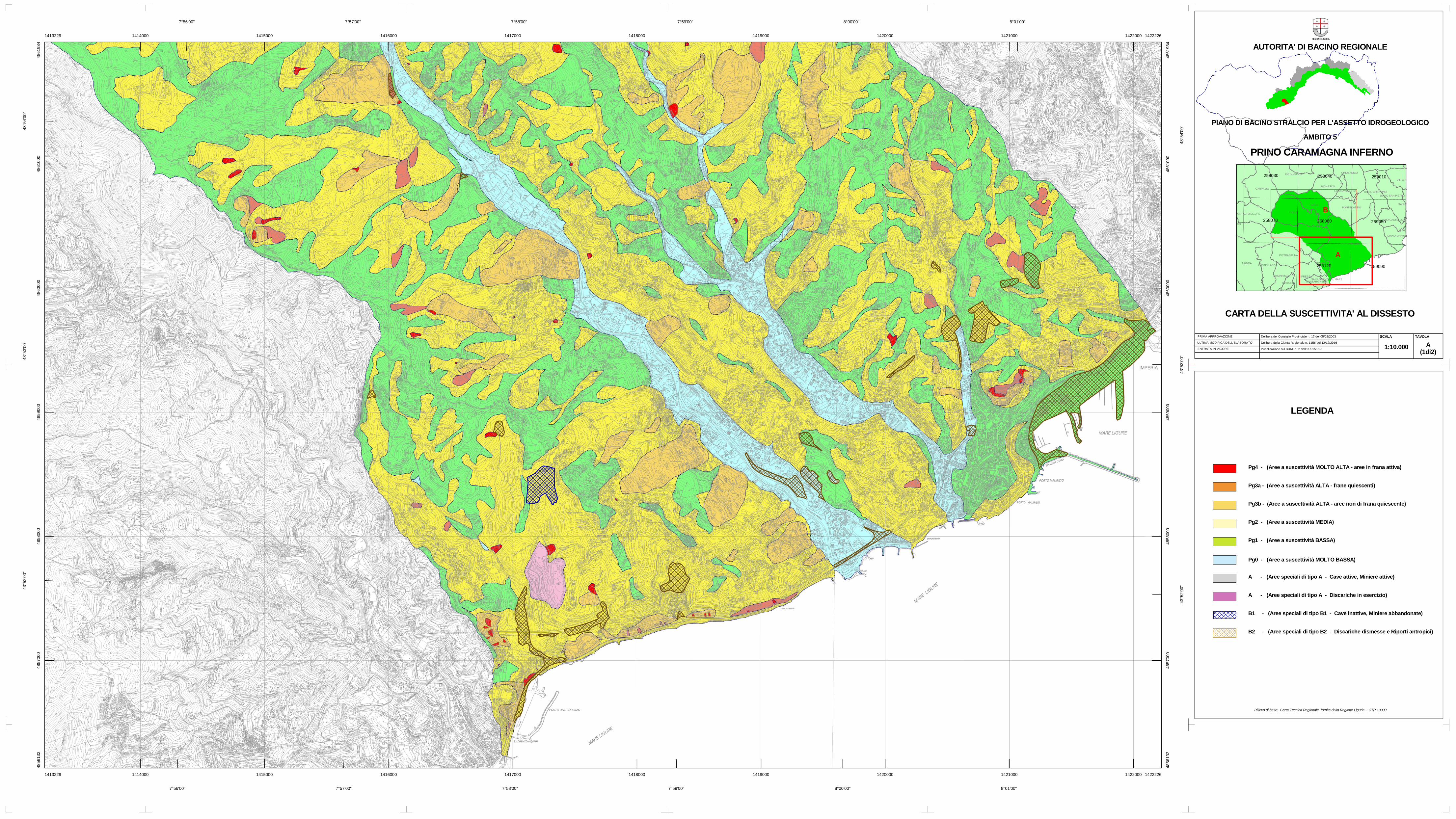
LEGENDA
Rilievo di base: Carta Tecnica Regionale fornita dalla Regione Liguria - CTR 10000
AUTORITA' DI BACINO REGIONALE
PIANO DI BACINO STRALCIO PER L'ASSETTO IDROGEOLOGICO
PRINO CARAMAGNA INFERNOAMBITO 5
CARTA DELLA SUSCETTIVITA' AL DISSESTO
PRIMA APPROVAZIONE
ULTIMA MODIFICA DELL'ELABORATO
ENTRATA IN VIGORE
Delibera del Consiglio Provinciale n. 17 del 05/02/2003
Delibera della Giunta Regionale n. 1156 del 12/12/2016
SCALA TAVOLA
1:10.000 A(1di2)
CCO
CASTELLARO
POMPEIANA
TERZORIO
TAGGIA
PIETRABRUNA
CIPRESSA
COSTARAINERASAN LORENZO AL MARE
CIVEZZA
IMPERIA
MONTALTO LIGURE PRELA'
DOLCEDO
VASIA
CARPASIO
BORGOMARO
LUCINASCO
CHIUSAVECCHIA
DIANO MARINA
DIANO CASTELLO
PONTEDASSIO
DIANO SAN PIETRO
SAN B
CHIUSANICO
DIANO ARENTINO
VILLA F
258120
258080258070
258030
259090
259050
258040 259010
A
B
A - (Aree speciali di tipo A - Cave attive, Miniere attive)
A - (Aree speciali di tipo A - Discariche in esercizio)
B1 - (Aree speciali di tipo B1 - Cave inattive, Miniere abbandonate)
B2 - (Aree speciali di tipo B2 - Discariche dismesse e Riporti antropici)
Pg0 - (Aree a suscettività MOLTO BASSA)
Pg1 - (Aree a suscettività BASSA)
Pg2 - (Aree a suscettività MEDIA)
Pg3a - (Aree a suscettività ALTA - frane quiescenti)
Pg3b - (Aree a suscettività ALTA - aree non di frana quiescente)
Pg4 - (Aree a suscettività MOLTO ALTA - aree in frana attiva)
Pubblicazione sul BURL n. 2 dell'11/01/2017
Recommended