WESTERN TURNER SYNCLINE STAGE 2
B1 and S17 Deposits
Assessment on Proponent Information Environmental Review Document
Hamersley Iron Pty Limited
152‐158 St Georges Terrace, Perth
GPO Box A42, Perth, WA 6837
April 2013
Page ii
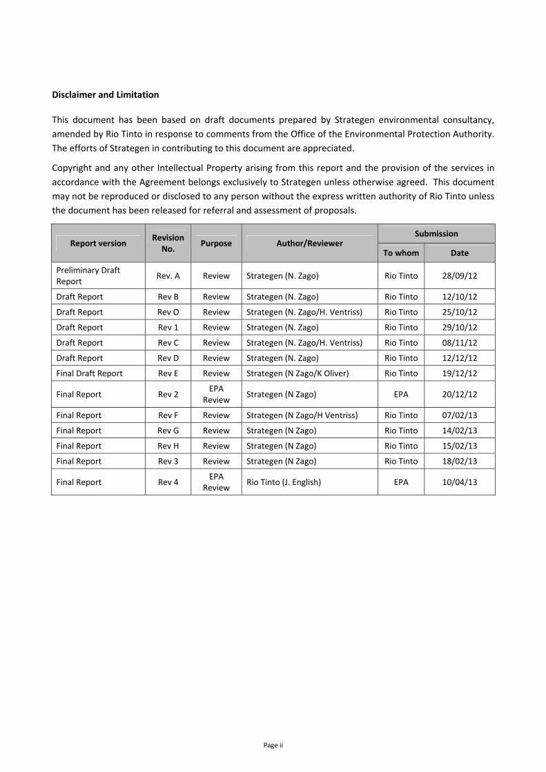
Disclaimer and Limitation
This document has been based on draft documents prepared by Strategen environmental consultancy,
amended by Rio Tinto in response to comments from the Office of the Environmental Protection Authority.
The efforts of Strategen in contributing to this document are appreciated.
Copyright and any other Intellectual Property arising from this report and the provision of the services in
accordance with the Agreement belongs exclusively to Strategen unless otherwise agreed. This document
may not be reproduced or disclosed to any person without the express written authority of Rio Tinto unless
the document has been released for referral and assessment of proposals.
Report version Revision
No. Purpose Author/Reviewer
Submission
To whom Date
Preliminary Draft Report
Rev. A Review Strategen (N. Zago) Rio Tinto 28/09/12
Draft Report Rev B Review Strategen (N. Zago) Rio Tinto 12/10/12
Draft Report Rev O Review Strategen (N. Zago/H. Ventriss) Rio Tinto 25/10/12
Draft Report Rev 1 Review Strategen (N. Zago) Rio Tinto 29/10/12
Draft Report Rev C Review Strategen (N. Zago/H. Ventriss) Rio Tinto 08/11/12
Draft Report Rev D Review Strategen (N. Zago) Rio Tinto 12/12/12
Final Draft Report Rev E Review Strategen (N Zago/K Oliver) Rio Tinto 19/12/12
Final Report Rev 2 EPA
Review Strategen (N Zago) EPA 20/12/12
Final Report Rev F Review Strategen (N Zago/H Ventriss) Rio Tinto 07/02/13
Final Report Rev G Review Strategen (N Zago) Rio Tinto 14/02/13
Final Report Rev H Review Strategen (N Zago) Rio Tinto 15/02/13
Final Report Rev 3 Review Strategen (N Zago) Rio Tinto 18/02/13
Final Report Rev 4 EPA
Review Rio Tinto (J. English) EPA 10/04/13
Western Turner Syncline Stage 2 – B1 and S17 Deposits API: Environmental Review Document
Page iii
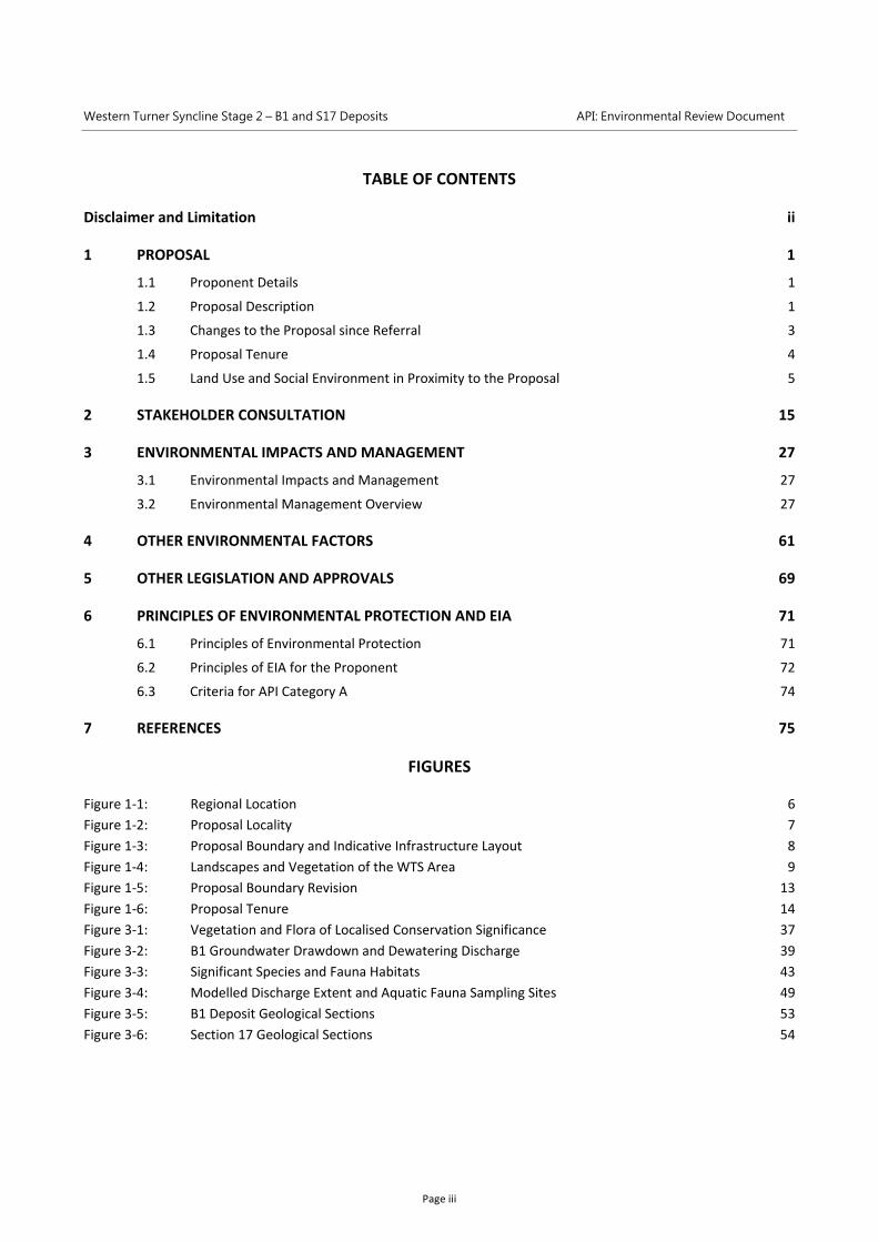
TABLE OF CONTENTS
Disclaimer and Limitation ii
1 PROPOSAL 1
1.1 Proponent Details 1
1.2 Proposal Description 1
1.3 Changes to the Proposal since Referral 3
1.4 Proposal Tenure 4
1.5 Land Use and Social Environment in Proximity to the Proposal 5
2 STAKEHOLDER CONSULTATION 15
3 ENVIRONMENTAL IMPACTS AND MANAGEMENT 27
3.1 Environmental Impacts and Management 27
3.2 Environmental Management Overview 27
4 OTHER ENVIRONMENTAL FACTORS 61
5 OTHER LEGISLATION AND APPROVALS 69
6 PRINCIPLES OF ENVIRONMENTAL PROTECTION AND EIA 71
6.1 Principles of Environmental Protection 71
6.2 Principles of EIA for the Proponent 72
6.3 Criteria for API Category A 74
7 REFERENCES 75
FIGURES
Figure 1‐1: Regional Location 6
Figure 1‐2: Proposal Locality 7
Figure 1‐3: Proposal Boundary and Indicative Infrastructure Layout 8
Figure 1‐4: Landscapes and Vegetation of the WTS Area 9
Figure 1‐5: Proposal Boundary Revision 13
Figure 1‐6: Proposal Tenure 14
Figure 3‐1: Vegetation and Flora of Localised Conservation Significance 37
Figure 3‐2: B1 Groundwater Drawdown and Dewatering Discharge 39
Figure 3‐3: Significant Species and Fauna Habitats 43
Figure 3‐4: Modelled Discharge Extent and Aquatic Fauna Sampling Sites 49
Figure 3‐5: B1 Deposit Geological Sections 53
Figure 3‐6: Section 17 Geological Sections 54
Western Turner Syncline Stage 2 – B1 and S17 Deposits API: Environmental Review Document
Page iv
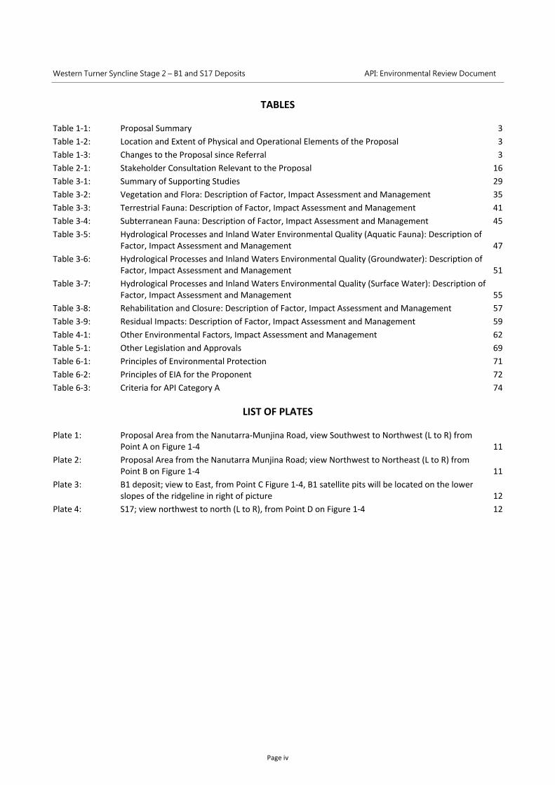
TABLES
Table 1‐1: Proposal Summary 3
Table 1‐2: Location and Extent of Physical and Operational Elements of the Proposal 3
Table 1‐3: Changes to the Proposal since Referral 3
Table 2‐1: Stakeholder Consultation Relevant to the Proposal 16
Table 3‐1: Summary of Supporting Studies 29
Table 3‐2: Vegetation and Flora: Description of Factor, Impact Assessment and Management 35
Table 3‐3: Terrestrial Fauna: Description of Factor, Impact Assessment and Management 41
Table 3‐4: Subterranean Fauna: Description of Factor, Impact Assessment and Management 45
Table 3‐5: Hydrological Processes and Inland Water Environmental Quality (Aquatic Fauna): Description of Factor, Impact Assessment and Management 47
Table 3‐6: Hydrological Processes and Inland Waters Environmental Quality (Groundwater): Description of Factor, Impact Assessment and Management 51
Table 3‐7: Hydrological Processes and Inland Waters Environmental Quality (Surface Water): Description of Factor, Impact Assessment and Management 55
Table 3‐8: Rehabilitation and Closure: Description of Factor, Impact Assessment and Management 57
Table 3‐9: Residual Impacts: Description of Factor, Impact Assessment and Management 59
Table 4‐1: Other Environmental Factors, Impact Assessment and Management 62
Table 5‐1: Other Legislation and Approvals 69
Table 6‐1: Principles of Environmental Protection 71
Table 6‐2: Principles of EIA for the Proponent 72
Table 6‐3: Criteria for API Category A 74
LIST OF PLATES
Plate 1: Proposal Area from the Nanutarra‐Munjina Road, view Southwest to Northwest (L to R) from Point A on Figure 1‐4 11
Plate 2: Proposal Area from the Nanutarra Munjina Road; view Northwest to Northeast (L to R) from Point B on Figure 1‐4 11
Plate 3: B1 deposit; view to East, from Point C Figure 1‐4, B1 satellite pits will be located on the lower slopes of the ridgeline in right of picture 12
Plate 4: S17; view northwest to north (L to R), from Point D on Figure 1‐4 12
Western Turner Syncline Stage 2 – B1 and S17 Deposits API: Environmental Review Document
Page v
APPENDICES
Appendix 1 Supporting Tables 79
Appendix 2 A Vegetation and Flora Survey of the West Turner Section 10 Area and Infrastructure Corridor (Biota 2007). 89
Appendix 3 West Turner Syncline Section 10 Development Two‐Phase Fauna Survey (Biota 2009a). 89
Appendix 4 A Two‐Phase Fauna Survey of the West Turner Syncline Area, (Biota 2009b). 89
Appendix 5 West Turner Targeted Fauna Survey (Biota 2011a). 89
Appendix 6 West Turner Syncline Section 10 Expanded Vegetation and Flora Survey Report (Biota 2011b). 89
Appendix 7 West Turner Syncline Phase 2 Vegetation and Flora Report (Biota 2013a). 89
Appendix 8 West Turner Syncline NES Species Assessment (Biota 2012a). 89
Appendix 9 West Turner Syncline Fauna Survey Summary Report (Biota 2012b). 89
Appendix 10 West Turner Syncline Stage 2 – Phase 1 Survey and Targeted Vegetation Survey (Biota 2013b). 89
Appendix 11 West Turner Syncline Stage 2 B1 and Section 17 Deposits Subterranean Fauna Survey (Biota 2012c). 89
Appendix 12 Western Turner Syncline Stage 2 Visual Impact Assessment (Ecoscape 2012). 89
Appendix 13 Predicted Dust Levels from Western Turner Syncline Stage 2 (B1 and S17) Iron Ore Project (Environmental Alliances 2012). 89
Appendix 14 Western Turner Syncline Stage 2 Project Ecological Risk Assessment (Equinox Environmental 2012). 89
Appendix 15 WTS2 B1 Water Quality Assessment (KCB 2012b). 89
Appendix 16 Potential Impacts of Dewatering and Discharge to Duck Creek and Caves Creek, Greater Nammuldi (Rio Tinto 2011). 89
Appendix 17 Baseline Hydrology Assessment for Local Creek Discharge from WTS B1 (Rio Tinto 2012a). 89
Appendix 18 Western Turner Syncline B1 – Feasibility Study Groundwater Modelling: Dewatering and Closure (Rio Tinto 2013a). 89
Appendix 19 WTS Phase II Surface Water Management, unpublished report prepared by Rio Tinto (Rio Tinto 2012c). 89
Appendix 20 Western Turner Syncline B1 – Feasibility Studies Groundwater Modelling: Dewatering and Closure (Rio Tinto 2012d). 89
Appendix 21 Surface hydrology in the vicinity of the WTS2 infrastructure corridor between WTS B1 and S10; assessment and modelling of natural surface flows (Rio Tinto 2012e). 89
Appendix 22 Western Turner Syncline B1 and S17 AMD Risk Assessment (Rio Tinto 2012f). 89
Appendix 23 Western Turner Syncline (Stage 2) Closure Plan (Rio Tinto 2012g). 89
Appendix 24 Environmental Noise Assessment of Western Turner Syncline Stage II Project (SVT 2012). 89
Appendix 25 West Turner Syncline Stage 2 ‐ Potential impacts of mining operations on overland flow dependent vegetation ‐ Preliminary assessment (UWA 2012a). 89
Appendix 26 West Turner Syncline Stage 2 ‐ Potential impacts of mining operations on groundwater dependent vegetation ‐ Preliminary assessment (UWA 2012b). 89
Appendix 27 Western Turner Syncline Project, wet & dry 2011 sampling, final report (WRM 2012a). 89
Appendix 28 WTS2 – groundwater quality updated data (WRM 2012b). 89
Appendix 29 WTS Stage 2 FS – Water balance & strategy update (Rio Tinto 2013b). 89
Appendix 30 Checklist for documents submitted for EIA on marine and terrestrial biodiversity. 89
Appendix 31 EPA prepared scoping guideline. 89

Western Turner Syncline Stage 2 – B1 and S17 Deposits API: Environmental Review Document
Page 1
1 PROPOSAL
The Proposal was referred to the Environmental Protection Authority (EPA) on 4 May 2012. The EPA set an
Assessment on Proponent Information (API) level of assessment under s 38 of the Environmental Protection
Act 1986 (EP Act) on 25 June 2012. An EPA prepared Environmental Scoping Document (ESD) was provided
on 5 October 2012. This Environmental Review document has been prepared in accordance with the ESD,
and the information requirements for a Category A API as set out in the Environmental Impact Assessment
(Part IV Divisions 1 and 2) Administrative Procedures 2012 (2012 Administrative Procedures).
1.1 Proponent Details
The Proponent for this Proposal is Hamersley Iron Pty Ltd.
Hamersley Iron Pty Limited
ABN: 49 004 558 276
GPO Box A42
PERTH WA 6837
The contact person for the Proposal is:
Jeremy English
Rio Tinto Iron Ore: Superintendent Approvals
T: +61 (0)8 9205 2919
1.2 Proposal Description
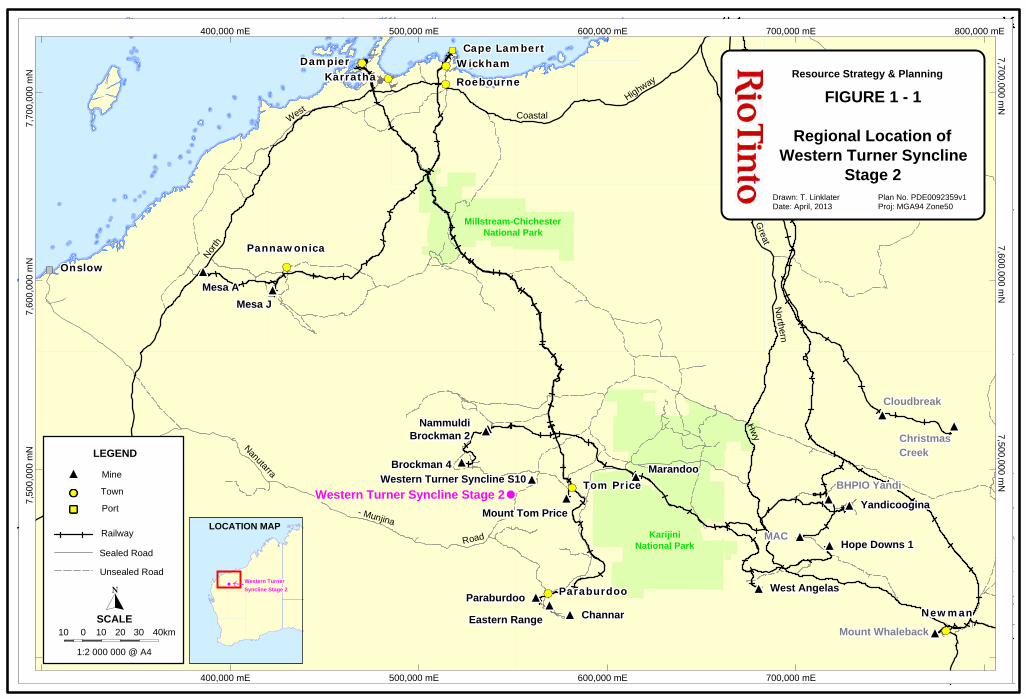
Hamersley Iron Pty Limited (a wholly‐owned subsidiary of Rio Tinto) proposes to develop the Western
Turner Syncline Stage 2 – B1 and Section 17 Deposits (Proposal), located approximately 30 km west of Tom
Price in the central Pilbara region of Western Australia (Figure 1‐1). The Proposal involves open‐pit mining
of the B1 and Section 17 (S17) iron ore deposits, transport of ore to the existing Western Turner Syncline
(WTS) Section 10 (S10) mine (approximately 12 km east of the B1 deposit) and construction/operation of
associated infrastructure (Figure 1‐2). The Proposal will operate at production rates of up to approximately
32 million tonnes per annum (Mtpa).
The Proposal will be integrated into the current Rio Tinto Greater Tom Price mining operation. After
transport to the WTS S10 mine, ore will be transferred via an existing transportation corridor to the Tom
Price mine for further processing, and subsequently to port facilities at Cape Lambert and Dampier via the
existing Rio Tinto rail network.
The main components of the Proposal comprise the following elements:
1. Open pit mining of iron ore at productions rates of up to approximately 32 Mtpa from the B1 deposit
(one main pit and four small satellite pits) and S17 deposit (eight pits) for at least 15 years.
2. An infrastructure corridor (approximate length of 12 km) linking B1 to the S10 mine site, including a
conveyor system, light and heavy vehicle access roads, above‐ground power lines, water pipelines
and communications.
Western Turner Syncline Stage 2 – B1 and S17 Deposits API: Environmental Review Document
Page 2
3. Mine support infrastructure (located predominantly near B1) including primary crushing facilities,
ROM pad, workshops, fuel storage/refuelling facilities, waste disposal facilities, explosives storage
facility, communications infrastructure, heavy and light vehicle access roads, power distribution
infrastructure, administration facilities, and other ancillary facilities as required.
4. Dewatering of the B1 main pit via in‐pit bores at extraction rates up to approximately 30 ML/day
(11 GL/annum) to enable mining to a depth of approximately 195 m below water table (BWT).
Required rates of dewatering are expected to peak in the first three years of operation and then
decline to approximately 14 ML/day from 2018 to 2027. The four B1 satellite pits are above water
table (AWT).
5. Minor dewatering of S17 pits 3 and 8 (to enable mining to approximately 15 m BWT); the other six
pits at S17 are AWT.
6. Water supply from mine dewatering with current demand expected to average approximately
6 ML/day.
7. Dewatering from the B1 deposit in excess of operational requirements will be discharged to a
watercourse north of the deposit (discharge watercourse), that joins the Beasley River 10 km
downstream of the discharge point. From 2015 to 2017, potential discharge of up to 30 ML/day
(excluding expected on‐site water use of 6 ML/day) is predicted to extend approximately 18 km
downstream of the discharge point. From 2018 to 2027, potential discharge of approximately
14 ML/day (excluding expected on‐site water use of 6 ML/day) is predicted to extend approximately
13 km downstream of the discharge point. With operational water use of approximately 6 ML/day,
discharge is expected to be <10 ML/day for the majority of the life of the Proposal.
8. Mineral waste disposal in permanent out‐of‐pit waste dumps. Progressive backfill of the B1 satellite
pits and S17 pits will be undertaken where practical, with prioritisation to ensure S17 pits 3 and 8 are
backfilled to a level sufficient to prevent formation of pit lakes.
9. Stockpiling of high grade and low‐grade ore, topsoil and subsoil.
10. Power supply through connection to existing Rio Tinto power supply network. Diesel generators will
be used during construction and as emergency supply during operations.
11. Investigative and monitoring activities.
The Proposal boundary, and indicative layout of the main mine and infrastructure components (during
Feasibility Study) is illustrated in Figure 1‐3. The proposed extent of clearing (2700 ha) within the Proposal
boundary (8430 ha) allows for an approximately 30% larger footprint than the current indicative layout.
This is to enable:
• potential design modifications during the Proposal Feasibility Study, detailed design, construction
and operational phases;
• temporary construction disturbance;
• additional minor infrastructure components and activities.
Landscapes and vegetation of the WTS area, where the Proposal is located, are illustrated in Figure 1‐4 and
Plate 1 to Plate 4.
Table 1‐1 summarises the Proposal and Table 1‐2 details the key characteristics of the Proposal.
Western Turner Syncline Stage 2 – B1 and S17 Deposits API: Environmental Review Document
Page 3
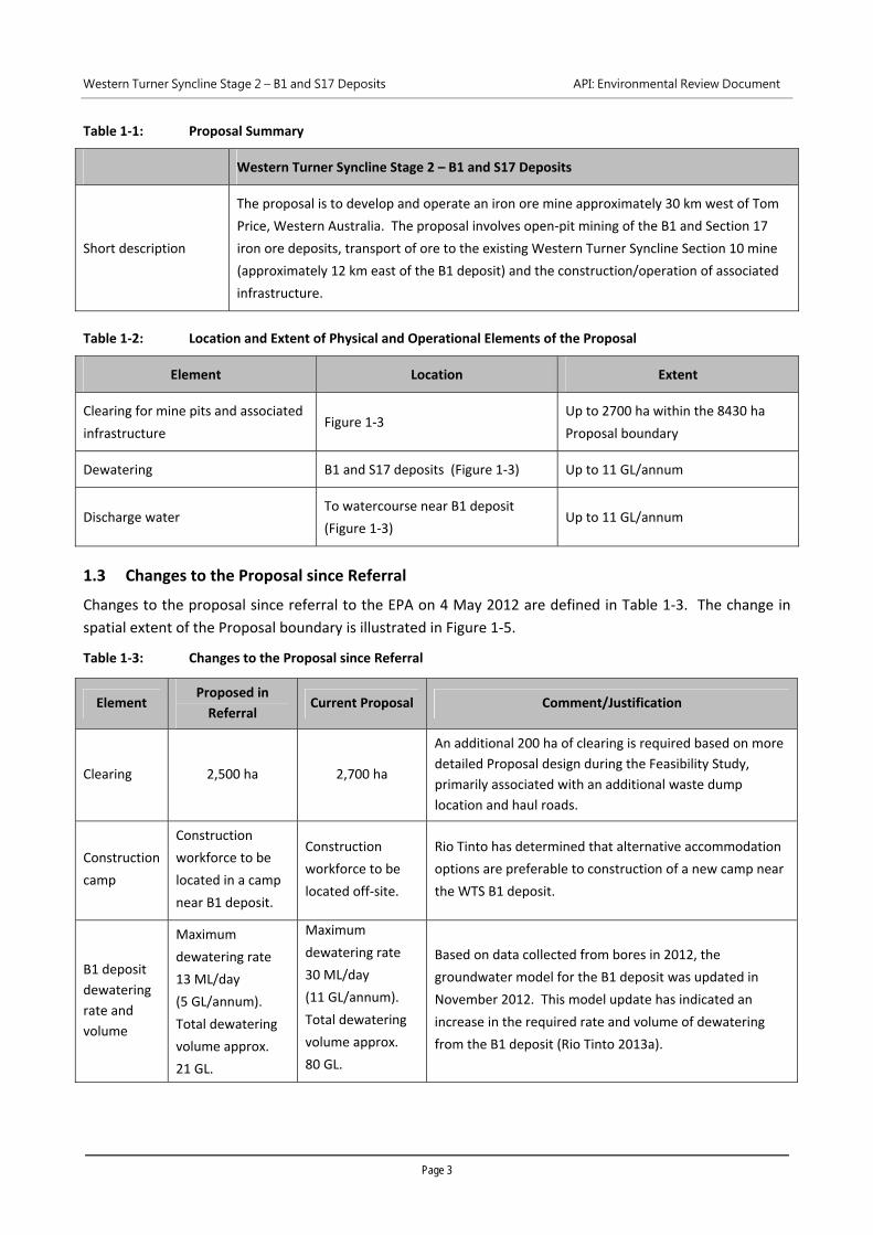
Table 1‐1: Proposal Summary
Western Turner Syncline Stage 2 – B1 and S17 Deposits
Short description
The proposal is to develop and operate an iron ore mine approximately 30 km west of Tom
Price, Western Australia. The proposal involves open‐pit mining of the B1 and Section 17
iron ore deposits, transport of ore to the existing Western Turner Syncline Section 10 mine
(approximately 12 km east of the B1 deposit) and the construction/operation of associated
infrastructure.
Table 1‐2: Location and Extent of Physical and Operational Elements of the Proposal
Element Location Extent
Clearing for mine pits and associated
infrastructure Figure 1‐3
Up to 2700 ha within the 8430 ha
Proposal boundary
Dewatering B1 and S17 deposits (Figure 1‐3) Up to 11 GL/annum
Discharge water To watercourse near B1 deposit
(Figure 1‐3) Up to 11 GL/annum
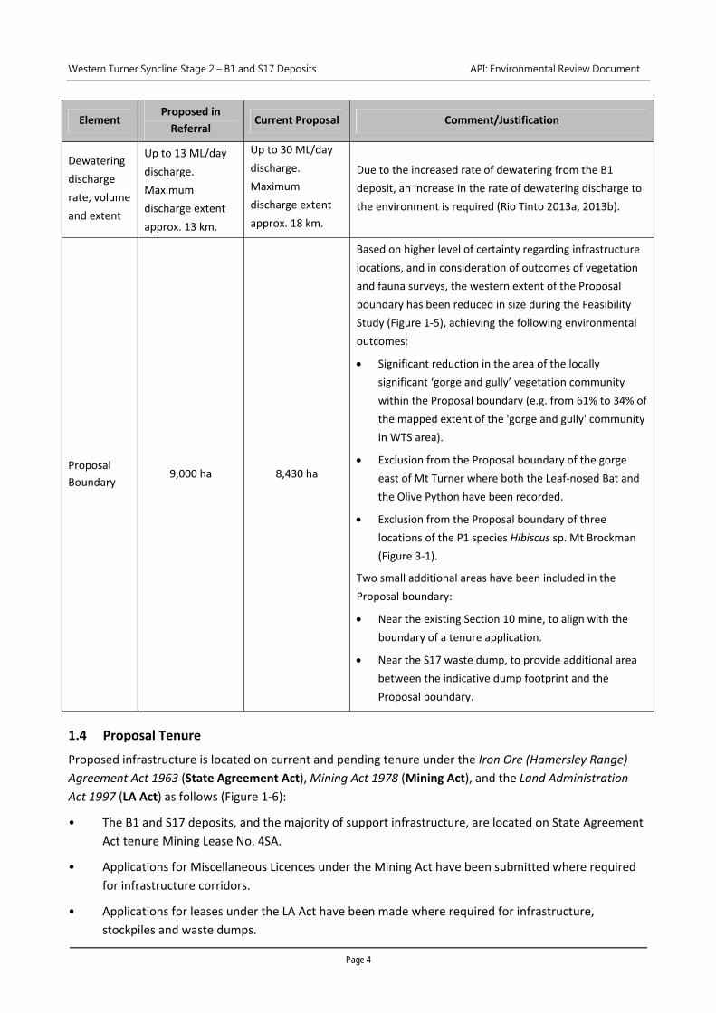
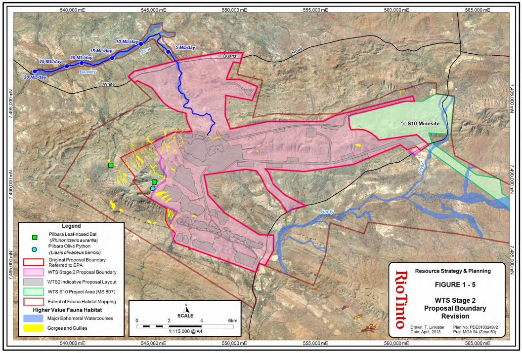
1.3 Changes to the Proposal since Referral
Changes to the proposal since referral to the EPA on 4 May 2012 are defined in Table 1‐3. The change in
spatial extent of the Proposal boundary is illustrated in Figure 1‐5.
Table 1‐3: Changes to the Proposal since Referral
Element Proposed in
Referral Current Proposal Comment/Justification
Clearing 2,500 ha 2,700 ha
An additional 200 ha of clearing is required based on more
detailed Proposal design during the Feasibility Study,
primarily associated with an additional waste dump
location and haul roads.
Construction
camp
Construction
workforce to be
located in a camp
near B1 deposit.
Construction
workforce to be
located off‐site.
Rio Tinto has determined that alternative accommodation
options are preferable to construction of a new camp near
the WTS B1 deposit.
B1 deposit
dewatering
rate and
volume
Maximum
dewatering rate
13 ML/day
(5 GL/annum).
Total dewatering
volume approx.
21 GL.
Maximum
dewatering rate
30 ML/day
(11 GL/annum).
Total dewatering
volume approx.
80 GL.
Based on data collected from bores in 2012, the
groundwater model for the B1 deposit was updated in
November 2012. This model update has indicated an
increase in the required rate and volume of dewatering
from the B1 deposit (Rio Tinto 2013a).
Western Turner Syncline Stage 2 – B1 and S17 Deposits API: Environmental Review Document
Page 4
Element Proposed in
Referral Current Proposal Comment/Justification
Dewatering
discharge
rate, volume
and extent
Up to 13 ML/day
discharge.
Maximum
discharge extent
approx. 13 km.
Up to 30 ML/day
discharge.
Maximum
discharge extent
approx. 18 km.
Due to the increased rate of dewatering from the B1
deposit, an increase in the rate of dewatering discharge to
the environment is required (Rio Tinto 2013a, 2013b).
Proposal
Boundary 9,000 ha 8,430 ha
Based on higher level of certainty regarding infrastructure
locations, and in consideration of outcomes of vegetation
and fauna surveys, the western extent of the Proposal
boundary has been reduced in size during the Feasibility
Study (Figure 1‐5), achieving the following environmental
outcomes:
Significant reduction in the area of the locally
significant ‘gorge and gully’ vegetation community
within the Proposal boundary (e.g. from 61% to 34% of
the mapped extent of the 'gorge and gully' community
in WTS area).
Exclusion from the Proposal boundary of the gorge
east of Mt Turner where both the Leaf‐nosed Bat and
the Olive Python have been recorded.
Exclusion from the Proposal boundary of three
locations of the P1 species Hibiscus sp. Mt Brockman
(Figure 3‐1).
Two small additional areas have been included in the
Proposal boundary:
Near the existing Section 10 mine, to align with the
boundary of a tenure application.
Near the S17 waste dump, to provide additional area
between the indicative dump footprint and the
Proposal boundary.
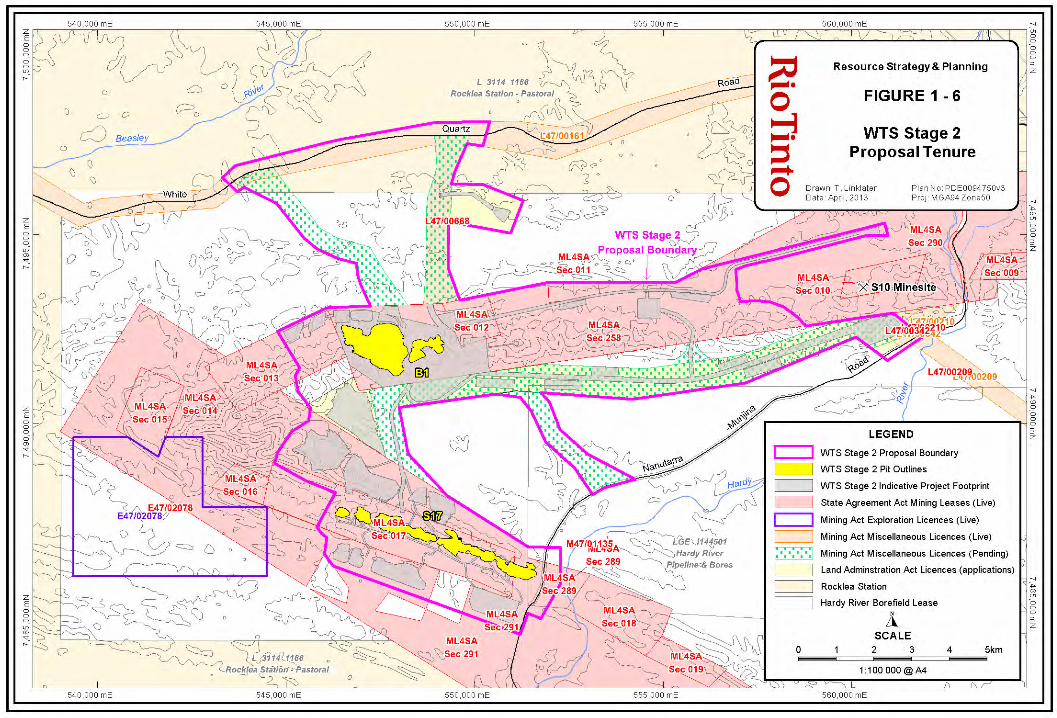
1.4 Proposal Tenure
Proposed infrastructure is located on current and pending tenure under the Iron Ore (Hamersley Range)
Agreement Act 1963 (State Agreement Act), Mining Act 1978 (Mining Act), and the Land Administration
Act 1997 (LA Act) as follows (Figure 1‐6):
• The B1 and S17 deposits, and the majority of support infrastructure, are located on State Agreement
Act tenure Mining Lease No. 4SA.
• Applications for Miscellaneous Licences under the Mining Act have been submitted where required
for infrastructure corridors.
• Applications for leases under the LA Act have been made where required for infrastructure,
stockpiles and waste dumps.
Western Turner Syncline Stage 2 – B1 and S17 Deposits API: Environmental Review Document
Page 5
The Proposal boundary incorporates some 'off tenure' areas where tenure is held by third parties
(Exploration Licences under the Mining Act). While Proposal infrastructure is not planned to be located in
these areas, they are included within the Proposal boundary to provide some flexibility if locations of
infrastructure are modified during ongoing Proposal planning, or preferred tenure locations cannot be
obtained.
If any additional 'off‐tenure' areas are required due to modifications in planned location of infrastructure,
suitable tenure and other legislative approvals required will be obtained prior to implementing activities
within these areas.
1.5 Land Use and Social Environment in Proximity to the Proposal
The Proposal is located within the Shire of Ashburton (Pilbara Region), approximately 30 km west of the
town of Tom Price. Landscapes and vegetation of the WTS area, where the Proposal is located, are
illustrated in Figure 1‐4 and Plate 1 to Plate 4.
The Proposal is located within the traditional lands of the Eastern Guruma people, and the Yinhawangka
people. The B1 deposit occurs within the Eastern Guruma native title claim area (WC97/89). Rio Tinto
entered into an Indigenous Land Use Agreement (ILUA) with the Eastern Guruma People on 13 February
2008. The S17 deposit occurs within the Yinhawangka native title claim area (WC10/16). Rio Tinto has a
Multiple Project Binding Agreement with the Yinhawangka people, and is currently in negotiations with a
view to reaching a commercial Participation Agreement, that will be registered later as an ILUA.
The Rocklea pastoral station (leased and operated by Hamersley Iron) is partially intersected by the north
of the Proposal boundary, and occurs in close proximity to the west (4 km) and south (200 m) of the
Proposal boundary (Figure 1‐6). The Hardey River borefield, that provides water to the Tom Price mining
operation, occurs to the south east of the Proposal boundary, on a Land Act lease, held by Hamersley Iron.
Mining operations in proximity to the Proposal include the WTS S10 mine (12 km to the east of B1), the
Tom Price mine (30 km southeast of B1) and the Brockman 4 mine (22 km northwest of B1), all owned and
operated by Hamersley Iron (Figure 1‐2). White Quartz Road, which passes through the north of the
Proposal boundary, is a sealed private road constructed and operated by Hamersley Iron that provides
access to the Brockman 4 mine site.
The Proposal boundary intersects, and occurs in proximity to, several Mining Act Exploration Licences held
by third parties. A proposed LA Act lease to be held by the Eastern Guruma is located approximately 1.4 km
west of the north‐west corner Proposal boundary, north of the White Quartz Road (Hamersley Iron has
agreed to excise this area from the Rocklea pastoral station). The proposed lease includes a ~3.6 km
section of the Beasley River, which is within the extent of dewatering discharge at rates >15 ML/day.
Karijini National Park, 18 km east of the Proposal boundary, is the only location registered on the Australian
Heritage Database in the vicinity of Tom Price. No Heritage Council of Western Australia listed sites occur
within the vicinity of the Proposal.
700,000 mE 800,000 mE7,600,000 m
N7,700,000 m
N
700,000 mE
7,500,000 mN
500,000 mE
500,000 mE
600,000 mE
600,000 mE
400,000 mE7,
600,
000
mN
7,70
0,00
0 m
N
400,000 mE
7,50
0,00
0 m
N
Millstream-ChichesterNational Park
KarijiniNational Park
Western Turner Syncline S10Western Turner Syncline S10Western Turner Syncline S10Western Turner Syncline S10Western Turner Syncline S10Western Turner Syncline S10Western Turner Syncline S10Western Turner Syncline S10Western Turner Syncline S10Western Turner Syncline S10Western Turner Syncline S10Western Turner Syncline S10Western Turner Syncline S10Western Turner Syncline S10Western Turner Syncline S10Western Turner Syncline S10Western Turner Syncline S10Western Turner Syncline S10Western Turner Syncline S10Western Turner Syncline S10Western Turner Syncline S10Western Turner Syncline S10Western Turner Syncline S10Western Turner Syncline S10Western Turner Syncline S10Western Turner Syncline S10Western Turner Syncline S10Western Turner Syncline S10Western Turner Syncline S10Western Turner Syncline S10Western Turner Syncline S10Western Turner Syncline S10Western Turner Syncline S10Western Turner Syncline S10Western Turner Syncline S10Western Turner Syncline S10Western Turner Syncline S10Western Turner Syncline S10Western Turner Syncline S10Western Turner Syncline S10Western Turner Syncline S10Western Turner Syncline S10Western Turner Syncline S10Western Turner Syncline S10Western Turner Syncline S10Western Turner Syncline S10Western Turner Syncline S10Western Turner Syncline S10Western Turner Syncline S10
Mount Tom PriceMount Tom PriceMount Tom PriceMount Tom PriceMount Tom PriceMount Tom PriceMount Tom PriceMount Tom PriceMount Tom PriceMount Tom PriceMount Tom PriceMount Tom PriceMount Tom PriceMount Tom PriceMount Tom PriceMount Tom PriceMount Tom PriceMount Tom PriceMount Tom PriceMount Tom PriceMount Tom PriceMount Tom PriceMount Tom PriceMount Tom PriceMount Tom PriceMount Tom PriceMount Tom PriceMount Tom PriceMount Tom PriceMount Tom PriceMount Tom PriceMount Tom PriceMount Tom PriceMount Tom PriceMount Tom PriceMount Tom PriceMount Tom PriceMount Tom PriceMount Tom PriceMount Tom PriceMount Tom PriceMount Tom PriceMount Tom PriceMount Tom PriceMount Tom PriceMount Tom PriceMount Tom PriceMount Tom PriceMount Tom Price
Brockman 4Brockman 4Brockman 4Brockman 4Brockman 4Brockman 4Brockman 4Brockman 4Brockman 4Brockman 4Brockman 4Brockman 4Brockman 4Brockman 4Brockman 4Brockman 4Brockman 4Brockman 4Brockman 4Brockman 4Brockman 4Brockman 4Brockman 4Brockman 4Brockman 4Brockman 4Brockman 4Brockman 4Brockman 4Brockman 4Brockman 4Brockman 4Brockman 4Brockman 4Brockman 4Brockman 4Brockman 4Brockman 4Brockman 4Brockman 4Brockman 4Brockman 4Brockman 4Brockman 4Brockman 4Brockman 4Brockman 4Brockman 4Brockman 4
NammuldiNammuldiNammuldiNammuldiNammuldiNammuldiNammuldiNammuldiNammuldiNammuldiNammuldiNammuldiNammuldiNammuldiNammuldiNammuldiNammuldiNammuldiNammuldiNammuldiNammuldiNammuldiNammuldiNammuldiNammuldiNammuldiNammuldiNammuldiNammuldiNammuldiNammuldiNammuldiNammuldiNammuldiNammuldiNammuldiNammuldiNammuldiNammuldiNammuldiNammuldiNammuldiNammuldiNammuldiNammuldiNammuldiNammuldiNammuldiNammuldiBrockman 2Brockman 2Brockman 2Brockman 2Brockman 2Brockman 2Brockman 2Brockman 2Brockman 2Brockman 2Brockman 2Brockman 2Brockman 2Brockman 2Brockman 2Brockman 2Brockman 2Brockman 2Brockman 2Brockman 2Brockman 2Brockman 2Brockman 2Brockman 2Brockman 2Brockman 2Brockman 2Brockman 2Brockman 2Brockman 2Brockman 2Brockman 2Brockman 2Brockman 2Brockman 2Brockman 2Brockman 2Brockman 2Brockman 2Brockman 2Brockman 2Brockman 2Brockman 2Brockman 2Brockman 2Brockman 2Brockman 2Brockman 2Brockman 2
Mesa AMesa AMesa AMesa AMesa AMesa AMesa AMesa AMesa AMesa AMesa AMesa AMesa AMesa AMesa AMesa AMesa AMesa AMesa AMesa AMesa AMesa AMesa AMesa AMesa AMesa AMesa AMesa AMesa AMesa AMesa AMesa AMesa AMesa AMesa AMesa AMesa AMesa AMesa AMesa AMesa AMesa AMesa AMesa AMesa AMesa AMesa AMesa AMesa A
ChristmasChristmasChristmasChristmasChristmasChristmasChristmasChristmasChristmasChristmasChristmasChristmasChristmasChristmasChristmasChristmasChristmasChristmasChristmasChristmasChristmasChristmasChristmasChristmasChristmasChristmasChristmasChristmasChristmasChristmasChristmasChristmasChristmasChristmasChristmasChristmasChristmasChristmasChristmasChristmasChristmasChristmasChristmasChristmasChristmasChristmasChristmasChristmasChristmasCreekCreekCreekCreekCreekCreekCreekCreekCreekCreekCreekCreekCreekCreekCreekCreekCreekCreekCreekCreekCreekCreekCreekCreekCreekCreekCreekCreekCreekCreekCreekCreekCreekCreekCreekCreekCreekCreekCreekCreekCreekCreekCreekCreekCreekCreekCreekCreekCreek
CloudbreakCloudbreakCloudbreakCloudbreakCloudbreakCloudbreakCloudbreakCloudbreakCloudbreakCloudbreakCloudbreakCloudbreakCloudbreakCloudbreakCloudbreakCloudbreakCloudbreakCloudbreakCloudbreakCloudbreakCloudbreakCloudbreakCloudbreakCloudbreakCloudbreakCloudbreakCloudbreakCloudbreakCloudbreakCloudbreakCloudbreakCloudbreakCloudbreakCloudbreakCloudbreakCloudbreakCloudbreakCloudbreakCloudbreakCloudbreakCloudbreakCloudbreakCloudbreakCloudbreakCloudbreakCloudbreakCloudbreakCloudbreakCloudbreak
BHPIO YandiBHPIO YandiBHPIO YandiBHPIO YandiBHPIO YandiBHPIO YandiBHPIO YandiBHPIO YandiBHPIO YandiBHPIO YandiBHPIO YandiBHPIO YandiBHPIO YandiBHPIO YandiBHPIO YandiBHPIO YandiBHPIO YandiBHPIO YandiBHPIO YandiBHPIO YandiBHPIO YandiBHPIO YandiBHPIO YandiBHPIO YandiBHPIO YandiBHPIO YandiBHPIO YandiBHPIO YandiBHPIO YandiBHPIO YandiBHPIO YandiBHPIO YandiBHPIO YandiBHPIO YandiBHPIO YandiBHPIO YandiBHPIO YandiBHPIO YandiBHPIO YandiBHPIO YandiBHPIO YandiBHPIO YandiBHPIO YandiBHPIO YandiBHPIO YandiBHPIO YandiBHPIO YandiBHPIO YandiBHPIO Yandi
MarandooMarandooMarandooMarandooMarandooMarandooMarandooMarandooMarandooMarandooMarandooMarandooMarandooMarandooMarandooMarandooMarandooMarandooMarandooMarandooMarandooMarandooMarandooMarandooMarandooMarandooMarandooMarandooMarandooMarandooMarandooMarandooMarandooMarandooMarandooMarandooMarandooMarandooMarandooMarandooMarandooMarandooMarandooMarandooMarandooMarandooMarandooMarandooMarandoo
Mount WhalebackMount WhalebackMount WhalebackMount WhalebackMount WhalebackMount WhalebackMount WhalebackMount WhalebackMount WhalebackMount WhalebackMount WhalebackMount WhalebackMount WhalebackMount WhalebackMount WhalebackMount WhalebackMount WhalebackMount WhalebackMount WhalebackMount WhalebackMount WhalebackMount WhalebackMount WhalebackMount WhalebackMount WhalebackMount WhalebackMount WhalebackMount WhalebackMount WhalebackMount WhalebackMount WhalebackMount WhalebackMount WhalebackMount WhalebackMount WhalebackMount WhalebackMount WhalebackMount WhalebackMount WhalebackMount WhalebackMount WhalebackMount WhalebackMount WhalebackMount WhalebackMount WhalebackMount WhalebackMount WhalebackMount WhalebackMount Whaleback
ParaburdooParaburdooParaburdooParaburdooParaburdooParaburdooParaburdooParaburdooParaburdooParaburdooParaburdooParaburdooParaburdooParaburdooParaburdooParaburdooParaburdooParaburdooParaburdooParaburdooParaburdooParaburdooParaburdooParaburdooParaburdooParaburdooParaburdooParaburdooParaburdooParaburdooParaburdooParaburdooParaburdooParaburdooParaburdooParaburdooParaburdooParaburdooParaburdooParaburdooParaburdooParaburdooParaburdooParaburdooParaburdooParaburdooParaburdooParaburdooParaburdoo
Eastern RangeEastern RangeEastern RangeEastern RangeEastern RangeEastern RangeEastern RangeEastern RangeEastern RangeEastern RangeEastern RangeEastern RangeEastern RangeEastern RangeEastern RangeEastern RangeEastern RangeEastern RangeEastern RangeEastern RangeEastern RangeEastern RangeEastern RangeEastern RangeEastern RangeEastern RangeEastern RangeEastern RangeEastern RangeEastern RangeEastern RangeEastern RangeEastern RangeEastern RangeEastern RangeEastern RangeEastern RangeEastern RangeEastern RangeEastern RangeEastern RangeEastern RangeEastern RangeEastern RangeEastern RangeEastern RangeEastern RangeEastern RangeEastern Range
Mesa JMesa JMesa JMesa JMesa JMesa JMesa JMesa JMesa JMesa JMesa JMesa JMesa JMesa JMesa JMesa JMesa JMesa JMesa JMesa JMesa JMesa JMesa JMesa JMesa JMesa JMesa JMesa JMesa JMesa JMesa JMesa JMesa JMesa JMesa JMesa JMesa JMesa JMesa JMesa JMesa JMesa JMesa JMesa JMesa JMesa JMesa JMesa JMesa J
MACMACMACMACMACMACMACMACMACMACMACMACMACMACMACMACMACMACMACMACMACMACMACMACMACMACMACMACMACMACMACMACMACMACMACMACMACMACMACMACMACMACMACMACMACMACMACMACMAC
PannawonicaPannawonicaPannawonicaPannawonicaPannawonicaPannawonicaPannawonicaPannawonicaPannawonicaPannawonicaPannawonicaPannawonicaPannawonicaPannawonicaPannawonicaPannawonicaPannawonicaPannawonicaPannawonicaPannawonicaPannawonicaPannawonicaPannawonicaPannawonicaPannawonicaPannawonicaPannawonicaPannawonicaPannawonicaPannawonicaPannawonicaPannawonicaPannawonicaPannawonicaPannawonicaPannawonicaPannawonicaPannawonicaPannawonicaPannawonicaPannawonicaPannawonicaPannawonicaPannawonicaPannawonicaPannawonicaPannawonicaPannawonicaPannawonica
NewmanNewmanNewmanNewmanNewmanNewmanNewmanNewmanNewmanNewmanNewmanNewmanNewmanNewmanNewmanNewmanNewmanNewmanNewmanNewmanNewmanNewmanNewmanNewmanNewmanNewmanNewmanNewmanNewmanNewmanNewmanNewmanNewmanNewmanNewmanNewmanNewmanNewmanNewmanNewmanNewmanNewmanNewmanNewmanNewmanNewmanNewmanNewmanNewman
Marble BarMarble BarMarble BarMarble BarMarble BarMarble BarMarble BarMarble BarMarble BarMarble BarMarble BarMarble BarMarble BarMarble BarMarble BarMarble BarMarble BarMarble BarMarble BarMarble BarMarble BarMarble BarMarble BarMarble BarMarble BarMarble BarMarble BarMarble BarMarble BarMarble BarMarble BarMarble BarMarble BarMarble BarMarble BarMarble BarMarble BarMarble BarMarble BarMarble BarMarble BarMarble BarMarble BarMarble BarMarble BarMarble BarMarble BarMarble BarMarble Bar
KarrathaKarrathaKarrathaKarrathaKarrathaKarrathaKarrathaKarrathaKarrathaKarrathaKarrathaKarrathaKarrathaKarrathaKarrathaKarrathaKarrathaKarrathaKarrathaKarrathaKarrathaKarrathaKarrathaKarrathaKarrathaKarrathaKarrathaKarrathaKarrathaKarrathaKarrathaKarrathaKarrathaKarrathaKarrathaKarrathaKarrathaKarrathaKarrathaKarrathaKarrathaKarrathaKarrathaKarrathaKarrathaKarrathaKarrathaKarrathaKarrathaDampierDampierDampierDampierDampierDampierDampierDampierDampierDampierDampierDampierDampierDampierDampierDampierDampierDampierDampierDampierDampierDampierDampierDampierDampierDampierDampierDampierDampierDampierDampierDampierDampierDampierDampierDampierDampierDampierDampierDampierDampierDampierDampierDampierDampierDampierDampierDampierDampier
Western Turner Syncline Stage 2Western Turner Syncline S10Western Turner Syncline S10Western Turner Syncline S10Western Turner Syncline S10Western Turner Syncline S10Western Turner Syncline S10Western Turner Syncline S10Western Turner Syncline S10Western Turner Syncline S10Western Turner Syncline S10Western Turner Syncline S10Western Turner Syncline S10Western Turner Syncline S10Western Turner Syncline S10Western Turner Syncline S10Western Turner Syncline S10Western Turner Syncline S10Western Turner Syncline S10Western Turner Syncline S10Western Turner Syncline S10Western Turner Syncline S10Western Turner Syncline S10Western Turner Syncline S10Western Turner Syncline S10Western Turner Syncline S10Western Turner Syncline S10Western Turner Syncline S10Western Turner Syncline S10Western Turner Syncline S10Western Turner Syncline S10Western Turner Syncline S10Western Turner Syncline S10Western Turner Syncline S10Western Turner Syncline S10Western Turner Syncline S10Western Turner Syncline S10Western Turner Syncline S10Western Turner Syncline S10Western Turner Syncline S10Western Turner Syncline S10Western Turner Syncline S10Western Turner Syncline S10Western Turner Syncline S10Western Turner Syncline S10Western Turner Syncline S10Western Turner Syncline S10Western Turner Syncline S10Western Turner Syncline S10Western Turner Syncline S10
Mount Tom PriceMount Tom PriceMount Tom PriceMount Tom PriceMount Tom PriceMount Tom PriceMount Tom PriceMount Tom PriceMount Tom PriceMount Tom PriceMount Tom PriceMount Tom PriceMount Tom PriceMount Tom PriceMount Tom PriceMount Tom PriceMount Tom PriceMount Tom PriceMount Tom PriceMount Tom PriceMount Tom PriceMount Tom PriceMount Tom PriceMount Tom PriceMount Tom PriceMount Tom PriceMount Tom PriceMount Tom PriceMount Tom PriceMount Tom PriceMount Tom PriceMount Tom PriceMount Tom PriceMount Tom PriceMount Tom PriceMount Tom PriceMount Tom PriceMount Tom PriceMount Tom PriceMount Tom PriceMount Tom PriceMount Tom PriceMount Tom PriceMount Tom PriceMount Tom PriceMount Tom PriceMount Tom PriceMount Tom PriceMount Tom Price
Brockman 4Brockman 4Brockman 4Brockman 4Brockman 4Brockman 4Brockman 4Brockman 4Brockman 4Brockman 4Brockman 4Brockman 4Brockman 4Brockman 4Brockman 4Brockman 4Brockman 4Brockman 4Brockman 4Brockman 4Brockman 4Brockman 4Brockman 4Brockman 4Brockman 4Brockman 4Brockman 4Brockman 4Brockman 4Brockman 4Brockman 4Brockman 4Brockman 4Brockman 4Brockman 4Brockman 4Brockman 4Brockman 4Brockman 4Brockman 4Brockman 4Brockman 4Brockman 4Brockman 4Brockman 4Brockman 4Brockman 4Brockman 4Brockman 4
NammuldiNammuldiNammuldiNammuldiNammuldiNammuldiNammuldiNammuldiNammuldiNammuldiNammuldiNammuldiNammuldiNammuldiNammuldiNammuldiNammuldiNammuldiNammuldiNammuldiNammuldiNammuldiNammuldiNammuldiNammuldiNammuldiNammuldiNammuldiNammuldiNammuldiNammuldiNammuldiNammuldiNammuldiNammuldiNammuldiNammuldiNammuldiNammuldiNammuldiNammuldiNammuldiNammuldiNammuldiNammuldiNammuldiNammuldiNammuldiNammuldiBrockman 2Brockman 2Brockman 2Brockman 2Brockman 2Brockman 2Brockman 2Brockman 2Brockman 2Brockman 2Brockman 2Brockman 2Brockman 2Brockman 2Brockman 2Brockman 2Brockman 2Brockman 2Brockman 2Brockman 2Brockman 2Brockman 2Brockman 2Brockman 2Brockman 2Brockman 2Brockman 2Brockman 2Brockman 2Brockman 2Brockman 2Brockman 2Brockman 2Brockman 2Brockman 2Brockman 2Brockman 2Brockman 2Brockman 2Brockman 2Brockman 2Brockman 2Brockman 2Brockman 2Brockman 2Brockman 2Brockman 2Brockman 2Brockman 2
Mesa AMesa AMesa AMesa AMesa AMesa AMesa AMesa AMesa AMesa AMesa AMesa AMesa AMesa AMesa AMesa AMesa AMesa AMesa AMesa AMesa AMesa AMesa AMesa AMesa AMesa AMesa AMesa AMesa AMesa AMesa AMesa AMesa AMesa AMesa AMesa AMesa AMesa AMesa AMesa AMesa AMesa AMesa AMesa AMesa AMesa AMesa AMesa AMesa A
ChristmasChristmasChristmasChristmasChristmasChristmasChristmasChristmasChristmasChristmasChristmasChristmasChristmasChristmasChristmasChristmasChristmasChristmasChristmasChristmasChristmasChristmasChristmasChristmasChristmasChristmasChristmasChristmasChristmasChristmasChristmasChristmasChristmasChristmasChristmasChristmasChristmasChristmasChristmasChristmasChristmasChristmasChristmasChristmasChristmasChristmasChristmasChristmasChristmasCreekCreekCreekCreekCreekCreekCreekCreekCreekCreekCreekCreekCreekCreekCreekCreekCreekCreekCreekCreekCreekCreekCreekCreekCreekCreekCreekCreekCreekCreekCreekCreekCreekCreekCreekCreekCreekCreekCreekCreekCreekCreekCreekCreekCreekCreekCreekCreekCreek
CloudbreakCloudbreakCloudbreakCloudbreakCloudbreakCloudbreakCloudbreakCloudbreakCloudbreakCloudbreakCloudbreakCloudbreakCloudbreakCloudbreakCloudbreakCloudbreakCloudbreakCloudbreakCloudbreakCloudbreakCloudbreakCloudbreakCloudbreakCloudbreakCloudbreakCloudbreakCloudbreakCloudbreakCloudbreakCloudbreakCloudbreakCloudbreakCloudbreakCloudbreakCloudbreakCloudbreakCloudbreakCloudbreakCloudbreakCloudbreakCloudbreakCloudbreakCloudbreakCloudbreakCloudbreakCloudbreakCloudbreakCloudbreakCloudbreak
BHPIO YandiBHPIO YandiBHPIO YandiBHPIO YandiBHPIO YandiBHPIO YandiBHPIO YandiBHPIO YandiBHPIO YandiBHPIO YandiBHPIO YandiBHPIO YandiBHPIO YandiBHPIO YandiBHPIO YandiBHPIO YandiBHPIO YandiBHPIO YandiBHPIO YandiBHPIO YandiBHPIO YandiBHPIO YandiBHPIO YandiBHPIO YandiBHPIO YandiBHPIO YandiBHPIO YandiBHPIO YandiBHPIO YandiBHPIO YandiBHPIO YandiBHPIO YandiBHPIO YandiBHPIO YandiBHPIO YandiBHPIO YandiBHPIO YandiBHPIO YandiBHPIO YandiBHPIO YandiBHPIO YandiBHPIO YandiBHPIO YandiBHPIO YandiBHPIO YandiBHPIO YandiBHPIO YandiBHPIO YandiBHPIO Yandi
MarandooMarandooMarandooMarandooMarandooMarandooMarandooMarandooMarandooMarandooMarandooMarandooMarandooMarandooMarandooMarandooMarandooMarandooMarandooMarandooMarandooMarandooMarandooMarandooMarandooMarandooMarandooMarandooMarandooMarandooMarandooMarandooMarandooMarandooMarandooMarandooMarandooMarandooMarandooMarandooMarandooMarandooMarandooMarandooMarandooMarandooMarandooMarandooMarandoo
Mount WhalebackMount WhalebackMount WhalebackMount WhalebackMount WhalebackMount WhalebackMount WhalebackMount WhalebackMount WhalebackMount WhalebackMount WhalebackMount WhalebackMount WhalebackMount WhalebackMount WhalebackMount WhalebackMount WhalebackMount WhalebackMount WhalebackMount WhalebackMount WhalebackMount WhalebackMount WhalebackMount WhalebackMount WhalebackMount WhalebackMount WhalebackMount WhalebackMount WhalebackMount WhalebackMount WhalebackMount WhalebackMount WhalebackMount WhalebackMount WhalebackMount WhalebackMount WhalebackMount WhalebackMount WhalebackMount WhalebackMount WhalebackMount WhalebackMount WhalebackMount WhalebackMount WhalebackMount WhalebackMount WhalebackMount WhalebackMount Whaleback
ParaburdooParaburdooParaburdooParaburdooParaburdooParaburdooParaburdooParaburdooParaburdooParaburdooParaburdooParaburdooParaburdooParaburdooParaburdooParaburdooParaburdooParaburdooParaburdooParaburdooParaburdooParaburdooParaburdooParaburdooParaburdooParaburdooParaburdooParaburdooParaburdooParaburdooParaburdooParaburdooParaburdooParaburdooParaburdooParaburdooParaburdooParaburdooParaburdooParaburdooParaburdooParaburdooParaburdooParaburdooParaburdooParaburdooParaburdooParaburdooParaburdoo
Eastern RangeEastern RangeEastern RangeEastern RangeEastern RangeEastern RangeEastern RangeEastern RangeEastern RangeEastern RangeEastern RangeEastern RangeEastern RangeEastern RangeEastern RangeEastern RangeEastern RangeEastern RangeEastern RangeEastern RangeEastern RangeEastern RangeEastern RangeEastern RangeEastern RangeEastern RangeEastern RangeEastern RangeEastern RangeEastern RangeEastern RangeEastern RangeEastern RangeEastern RangeEastern RangeEastern RangeEastern RangeEastern RangeEastern RangeEastern RangeEastern RangeEastern RangeEastern RangeEastern RangeEastern RangeEastern RangeEastern RangeEastern RangeEastern Range
Mesa JMesa JMesa JMesa JMesa JMesa JMesa JMesa JMesa JMesa JMesa JMesa JMesa JMesa JMesa JMesa JMesa JMesa JMesa JMesa JMesa JMesa JMesa JMesa JMesa JMesa JMesa JMesa JMesa JMesa JMesa JMesa JMesa JMesa JMesa JMesa JMesa JMesa JMesa JMesa JMesa JMesa JMesa JMesa JMesa JMesa JMesa JMesa JMesa J
MACMACMACMACMACMACMACMACMACMACMACMACMACMACMACMACMACMACMACMACMACMACMACMACMACMACMACMACMACMACMACMACMACMACMACMACMACMACMACMACMACMACMACMACMACMACMACMACMAC
ChannarChannarChannarChannarChannarChannarChannarChannarChannarChannarChannarChannarChannarChannarChannarChannarChannarChannarChannarChannarChannarChannarChannarChannarChannarChannarChannarChannarChannarChannarChannarChannarChannarChannarChannarChannarChannarChannarChannarChannarChannarChannarChannarChannarChannarChannarChannarChannarChannar
West AngelasWest AngelasWest AngelasWest AngelasWest AngelasWest AngelasWest AngelasWest AngelasWest AngelasWest AngelasWest AngelasWest AngelasWest AngelasWest AngelasWest AngelasWest AngelasWest AngelasWest AngelasWest AngelasWest AngelasWest AngelasWest AngelasWest AngelasWest AngelasWest AngelasWest AngelasWest AngelasWest AngelasWest AngelasWest AngelasWest AngelasWest AngelasWest AngelasWest AngelasWest AngelasWest AngelasWest AngelasWest AngelasWest AngelasWest AngelasWest AngelasWest AngelasWest AngelasWest AngelasWest AngelasWest AngelasWest AngelasWest AngelasWest Angelas
YandicooginaYandicooginaYandicooginaYandicooginaYandicooginaYandicooginaYandicooginaYandicooginaYandicooginaYandicooginaYandicooginaYandicooginaYandicooginaYandicooginaYandicooginaYandicooginaYandicooginaYandicooginaYandicooginaYandicooginaYandicooginaYandicooginaYandicooginaYandicooginaYandicooginaYandicooginaYandicooginaYandicooginaYandicooginaYandicooginaYandicooginaYandicooginaYandicooginaYandicooginaYandicooginaYandicooginaYandicooginaYandicooginaYandicooginaYandicooginaYandicooginaYandicooginaYandicooginaYandicooginaYandicooginaYandicooginaYandicooginaYandicooginaYandicoogina
Hope Downs 1Hope Downs 1Hope Downs 1Hope Downs 1Hope Downs 1Hope Downs 1Hope Downs 1Hope Downs 1Hope Downs 1Hope Downs 1Hope Downs 1Hope Downs 1Hope Downs 1Hope Downs 1Hope Downs 1Hope Downs 1Hope Downs 1Hope Downs 1Hope Downs 1Hope Downs 1Hope Downs 1Hope Downs 1Hope Downs 1Hope Downs 1Hope Downs 1Hope Downs 1Hope Downs 1Hope Downs 1Hope Downs 1Hope Downs 1Hope Downs 1Hope Downs 1Hope Downs 1Hope Downs 1Hope Downs 1Hope Downs 1Hope Downs 1Hope Downs 1Hope Downs 1Hope Downs 1Hope Downs 1Hope Downs 1Hope Downs 1Hope Downs 1Hope Downs 1Hope Downs 1Hope Downs 1Hope Downs 1Hope Downs 1
PannawonicaPannawonicaPannawonicaPannawonicaPannawonicaPannawonicaPannawonicaPannawonicaPannawonicaPannawonicaPannawonicaPannawonicaPannawonicaPannawonicaPannawonicaPannawonicaPannawonicaPannawonicaPannawonicaPannawonicaPannawonicaPannawonicaPannawonicaPannawonicaPannawonicaPannawonicaPannawonicaPannawonicaPannawonicaPannawonicaPannawonicaPannawonicaPannawonicaPannawonicaPannawonicaPannawonicaPannawonicaPannawonicaPannawonicaPannawonicaPannawonicaPannawonicaPannawonicaPannawonicaPannawonicaPannawonicaPannawonicaPannawonicaPannawonica
NewmanNewmanNewmanNewmanNewmanNewmanNewmanNewmanNewmanNewmanNewmanNewmanNewmanNewmanNewmanNewmanNewmanNewmanNewmanNewmanNewmanNewmanNewmanNewmanNewmanNewmanNewmanNewmanNewmanNewmanNewmanNewmanNewmanNewmanNewmanNewmanNewmanNewmanNewmanNewmanNewmanNewmanNewmanNewmanNewmanNewmanNewmanNewmanNewman
Marble BarMarble BarMarble BarMarble BarMarble BarMarble BarMarble BarMarble BarMarble BarMarble BarMarble BarMarble BarMarble BarMarble BarMarble BarMarble BarMarble BarMarble BarMarble BarMarble BarMarble BarMarble BarMarble BarMarble BarMarble BarMarble BarMarble BarMarble BarMarble BarMarble BarMarble BarMarble BarMarble BarMarble BarMarble BarMarble BarMarble BarMarble BarMarble BarMarble BarMarble BarMarble BarMarble BarMarble BarMarble BarMarble BarMarble BarMarble BarMarble Bar
KarrathaKarrathaKarrathaKarrathaKarrathaKarrathaKarrathaKarrathaKarrathaKarrathaKarrathaKarrathaKarrathaKarrathaKarrathaKarrathaKarrathaKarrathaKarrathaKarrathaKarrathaKarrathaKarrathaKarrathaKarrathaKarrathaKarrathaKarrathaKarrathaKarrathaKarrathaKarrathaKarrathaKarrathaKarrathaKarrathaKarrathaKarrathaKarrathaKarrathaKarrathaKarrathaKarrathaKarrathaKarrathaKarrathaKarrathaKarrathaKarrathaDampierDampierDampierDampierDampierDampierDampierDampierDampierDampierDampierDampierDampierDampierDampierDampierDampierDampierDampierDampierDampierDampierDampierDampierDampierDampierDampierDampierDampierDampierDampierDampierDampierDampierDampierDampierDampierDampierDampierDampierDampierDampierDampierDampierDampierDampierDampierDampierDampier
Cape LambertCape LambertCape LambertCape LambertCape LambertCape LambertCape LambertCape LambertCape LambertCape LambertCape LambertCape LambertCape LambertCape LambertCape LambertCape LambertCape LambertCape LambertCape LambertCape LambertCape LambertCape LambertCape LambertCape LambertCape LambertCape LambertCape LambertCape LambertCape LambertCape LambertCape LambertCape LambertCape LambertCape LambertCape LambertCape LambertCape LambertCape LambertCape LambertCape LambertCape LambertCape LambertCape LambertCape LambertCape LambertCape LambertCape LambertCape LambertCape Lambert
OnslowOnslowOnslowOnslowOnslowOnslowOnslowOnslowOnslowOnslowOnslowOnslowOnslowOnslowOnslowOnslowOnslowOnslowOnslowOnslowOnslowOnslowOnslowOnslowOnslowOnslowOnslowOnslowOnslowOnslowOnslowOnslowOnslowOnslowOnslowOnslowOnslowOnslowOnslowOnslowOnslowOnslowOnslowOnslowOnslowOnslowOnslowOnslowOnslow
ParaburdooParaburdooParaburdooParaburdooParaburdooParaburdooParaburdooParaburdooParaburdooParaburdooParaburdooParaburdooParaburdooParaburdooParaburdooParaburdooParaburdooParaburdooParaburdooParaburdooParaburdooParaburdooParaburdooParaburdooParaburdooParaburdooParaburdooParaburdooParaburdooParaburdooParaburdooParaburdooParaburdooParaburdooParaburdooParaburdooParaburdooParaburdooParaburdooParaburdooParaburdooParaburdooParaburdooParaburdooParaburdooParaburdooParaburdooParaburdooParaburdoo
RoebourneRoebourneRoebourneRoebourneRoebourneRoebourneRoebourneRoebourneRoebourneRoebourneRoebourneRoebourneRoebourneRoebourneRoebourneRoebourneRoebourneRoebourneRoebourneRoebourneRoebourneRoebourneRoebourneRoebourneRoebourneRoebourneRoebourneRoebourneRoebourneRoebourneRoebourneRoebourneRoebourneRoebourneRoebourneRoebourneRoebourneRoebourneRoebourneRoebourneRoebourneRoebourneRoebourneRoebourneRoebourneRoebourneRoebourneRoebourneRoebourne
Tom PriceTom PriceTom PriceTom PriceTom PriceTom PriceTom PriceTom PriceTom PriceTom PriceTom PriceTom PriceTom PriceTom PriceTom PriceTom PriceTom PriceTom PriceTom PriceTom PriceTom PriceTom PriceTom PriceTom PriceTom PriceTom PriceTom PriceTom PriceTom PriceTom PriceTom PriceTom PriceTom PriceTom PriceTom PriceTom PriceTom PriceTom PriceTom PriceTom PriceTom PriceTom PriceTom PriceTom PriceTom PriceTom PriceTom PriceTom PriceTom Price
WickhamWickhamWickhamWickhamWickhamWickhamWickhamWickhamWickhamWickhamWickhamWickhamWickhamWickhamWickhamWickhamWickhamWickhamWickhamWickhamWickhamWickhamWickhamWickhamWickhamWickhamWickhamWickhamWickhamWickhamWickhamWickhamWickhamWickhamWickhamWickhamWickhamWickhamWickhamWickhamWickhamWickhamWickhamWickhamWickhamWickhamWickhamWickhamWickham
Western Turner Syncline Stage 2
LEGEND
1:2 000 000 @ A4
SCALE
LOCATION MAP
Town
Port
Railway
Sealed Road
Nor
th
West Coastal
Highway
Hw
y
Road
Nanutarra
Unsealed Road
10 0 10 20 30 40km
Mine
Western TurnerWestern TurnerWestern TurnerWestern TurnerWestern TurnerWestern TurnerWestern TurnerWestern TurnerWestern TurnerWestern TurnerWestern TurnerWestern TurnerWestern TurnerWestern TurnerWestern TurnerWestern TurnerWestern TurnerWestern TurnerWestern TurnerWestern TurnerWestern TurnerWestern TurnerWestern TurnerWestern TurnerWestern TurnerWestern TurnerWestern TurnerWestern TurnerWestern TurnerWestern TurnerWestern TurnerWestern TurnerWestern TurnerWestern TurnerWestern TurnerWestern TurnerWestern TurnerWestern TurnerWestern TurnerWestern TurnerWestern TurnerWestern TurnerWestern TurnerWestern TurnerWestern TurnerWestern TurnerWestern TurnerWestern TurnerWestern TurnerSyncline Stage 2Syncline Stage 2Syncline Stage 2Syncline Stage 2Syncline Stage 2Syncline Stage 2Syncline Stage 2Syncline Stage 2Syncline Stage 2Syncline Stage 2Syncline Stage 2Syncline Stage 2Syncline Stage 2Syncline Stage 2Syncline Stage 2Syncline Stage 2Syncline Stage 2Syncline Stage 2Syncline Stage 2Syncline Stage 2Syncline Stage 2Syncline Stage 2Syncline Stage 2Syncline Stage 2Syncline Stage 2Syncline Stage 2Syncline Stage 2Syncline Stage 2Syncline Stage 2Syncline Stage 2Syncline Stage 2Syncline Stage 2Syncline Stage 2Syncline Stage 2Syncline Stage 2Syncline Stage 2Syncline Stage 2Syncline Stage 2Syncline Stage 2Syncline Stage 2Syncline Stage 2Syncline Stage 2Syncline Stage 2Syncline Stage 2Syncline Stage 2Syncline Stage 2Syncline Stage 2Syncline Stage 2Syncline Stage 2
- Munjina
FIGURE 1 - 1
Regional Location ofWestern Turner Syncline
Stage 2Plan No. PDE0092359v1Proj: MGA94 Zone50
Drawn: T. LinklaterDate: April, 2013
Resource Strategy & Planning
Great
Northern
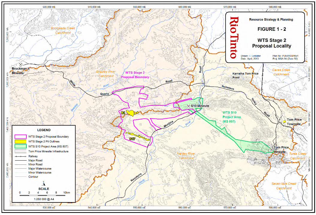
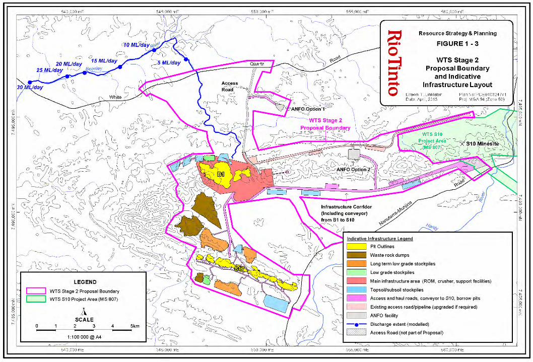
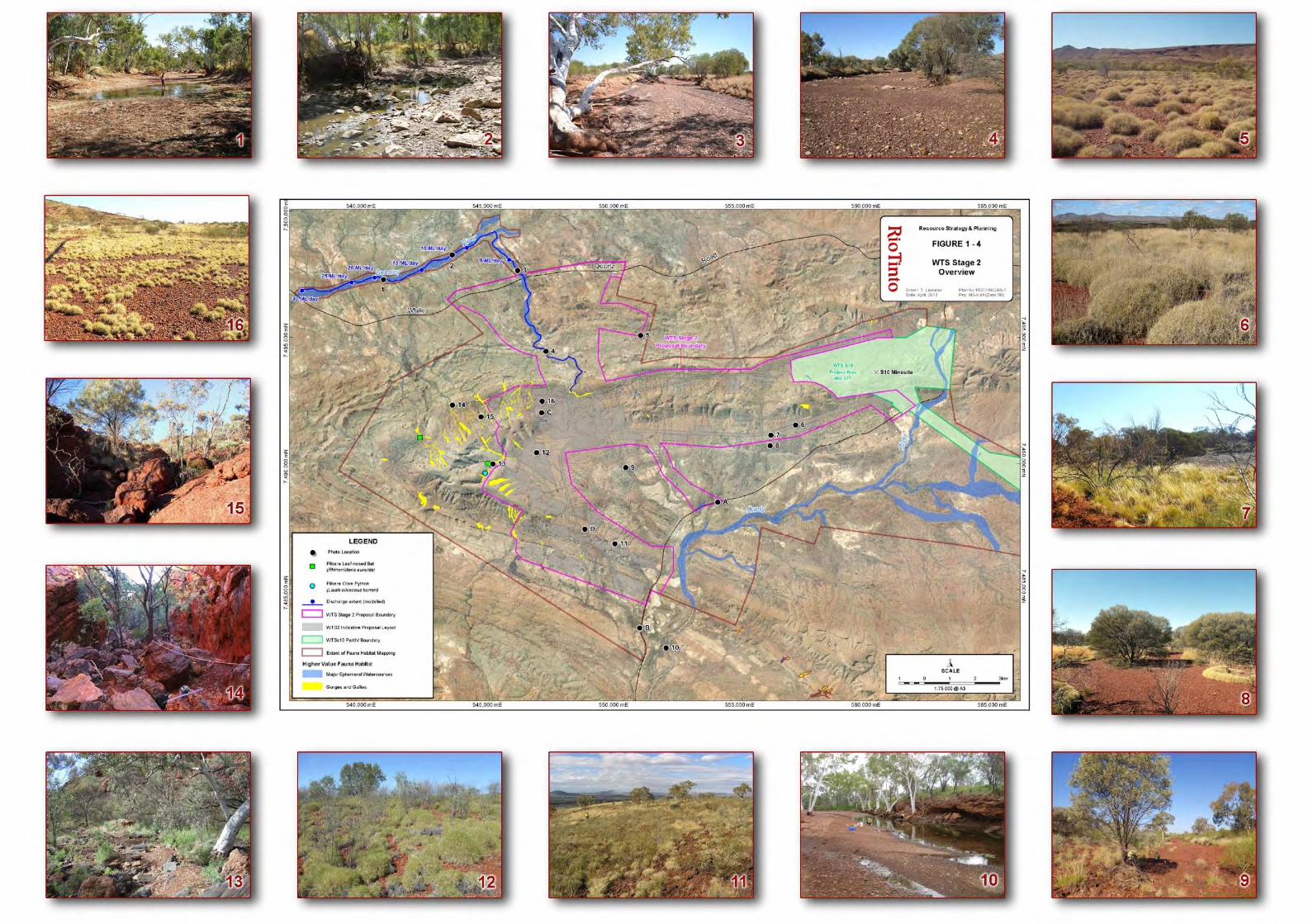

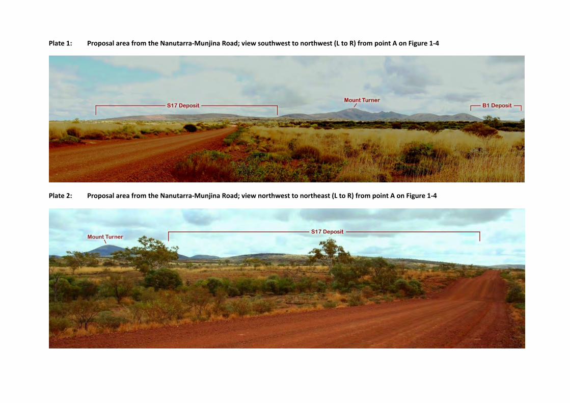
Plate 1: Proposal area from the Nanutarra‐Munjina Road; view southwest to northwest (L to R) from point A on Figure 1‐4
Plate 2: Proposal area from the Nanutarra‐Munjina Road; view northwest to northeast (L to R) from point A on Figure 1‐4
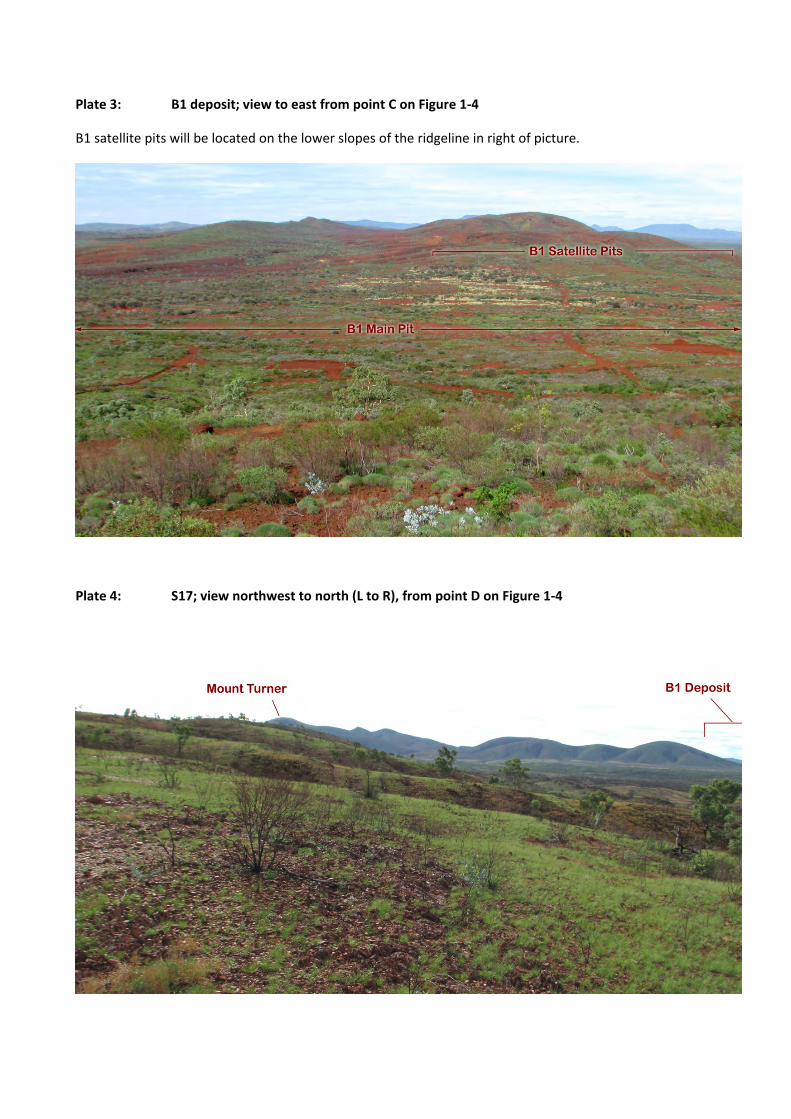
Plate 3: B1 deposit; view to east from point C on Figure 1‐4
B1 satellite pits will be located on the lower slopes of the ridgeline in right of picture.
Plate 4: S17; view northwest to north (L to R), from point D on Figure 1‐4
Western Turner Syncline Stage 2 – B1 and S17 Deposits API: Environmental Review Document
Page 15
2 STAKEHOLDER CONSULTATION
Identified key stakeholders for this project include:
Government agencies:
o Office of the Environmental Protection Authority (OEPA);
o Department of Environment and Conservation (DEC) – Pilbara Region, Perth Environmental
Management Branch (EMB), Perth Contaminated Sites Branch (CSB);
o Department of Mines and Petroleum (DMP);
o Department of State Development (DSD);
o Department of Water (DoW) – Pilbara regional office and Perth office;
o Department of Indigenous Affairs (DIA);
o Shire of Ashburton.
Traditional Owners:
o Eastern Guruma Group;
o Yinhawangka Group.
Stakeholder consultation undertaken to date, and Rio Tinto’s response to issues raised, is detailed in Table
2‐1. Rio Tinto will continue to consult with relevant stakeholders during the environmental approval
process, and during implementation of the Proposal.
Western Turner Syncline Stage 2 – B1 and S17 Deposits API: Environmental Review Document
Page 16
Table 2‐1: Stakeholder Consultation Relevant to the Proposal
Date Topics/Issues Raised Proponent Response
Office of the Environmental Protection Authority (OEPA)
29/02/2012
Rio Tinto provided a detailed overview of the Proposal, current/planned environmental studies, potential environmental impacts and proposed management.
OEPA advised the key issue for Proposal is likely to be associated with closure.
Rio Tinto has addressed closure as a key issue during the Environmental Impact Assessment (EIA) for the Proposal. A Proposal Closure Plan has been prepared in accordance with the Guidelines for Preparing Mine Closure Plans (DMP/EPA 2011), and is provided as Appendix 23.
OEPA advised the referral should include assessment of requirement for an offset in accordance with Appendix 2 of EPA Guidance Statement No. 19.
The referral document included an assessment of requirement for an offset.
A proposed offset package has been provided as a separate document to the Environmental Review.
3/09/2012 Discussion of key environmental factors identified in EPA‐prepared Environmental Scoping Document (ESD).
Rio Tinto to address key environmental factors in Environmental Review.
5/10/2012
Meeting included DMP.
Rio Tinto provided detailed overview of the Proposal, with focus on waste characterisation, pit lake water quality modelling, and closure management.
OEPA advised Environmental Review needs to clearly define whether impacts to potential groundwater‐dependent vegetation (GDV) are likely.
Environmental Review provides detail that impact to potential GDV in the WTS area is highly unlikely.
2/11/2012 Discussion of structure and content of Environmental Review document to be submitted for EPA assessment. General agreement reached.
Rio Tinto will prepare the Environmental Review document in accordance with the agreed approach.
30/01/2013 Discussion of OEPA comments on submitted Environmental Review document, and approach to address. General agreement reached.
Rio Tinto will revise Environmental Review document in accordance with agreed approach, and resubmit.
12/03/2013 Site visit to WTS2 with OEPA and DOW.
General discussion of relevant environmental factors and potential impacts.

Western Turner Syncline Stage 2 – B1 and S17 Deposits API: Environmental Review Document
Page 17
Date Topics/Issues Raised Proponent Response
DEC ‐ Environmental Management Branch (EMB)
20/02/2012
Rio Tinto provided a detailed overview of the Proposal, current/planned environmental studies, potential environmental impacts and proposed management, with focus on biological issues.
DEC advised the proposed approach to identify areas where potentially overland flow‐dependent vegetation may be impacted by the infrastructure corridor was reasonable.
Rio Tinto has subsequently implemented a more rigorous modelling approach to assess the potential impacts of the infrastructure corridor on surface hydrology (Appendix 21). This updated approach was discussed with DEC EMB on 23 October 2012.
DEC advised the proposed approach to assessment of impacts on troglofauna identified in the Proposal area (genetic analysis, habitat assessment) was reasonable.
Rio Tinto has implemented proposed approach, as detailed in the Environmental Review.
DEC queried the potential for further ‘gorge and gully’ vegetation to occur outside the Proposal boundary.
Rio Tinto implemented further surveys outside the Proposal boundary in 2012, and has identified further areas of ‘gorge and gully’ vegetation within the Environmental Review (Figure 3‐1).
DEC queried the timeframe to further develop understanding of likely pit lake water quality at the B1 deposit, and proposed management.
Rio Tinto has undertaken 2 phases of pit lake water quality modelling in 2012 (Appendix 15). The modelling report is an appendix to the Environmental Review. The Closure Plan (Appendix 23) provides detail on proposed management of the pit lake.
23/10/2012
Rio Tinto provided an overview of the Proposal with focus on:
Outcomes of surface hydrology modelling that indicates any overland flow occurring in the vicinity of the proposed infrastructure corridor is highly unlikely (Appendix 21), and the approach is to optimise the location of culverts within watercourses.
Overview of subterranean fauna survey results, with focus on risk‐based approach that demonstrates Proposal is likely to comprise low risk to troglofauna based on (i) outcomes of genetic analysis of troglophiles collected at B1 and S17 deposits, and (ii) habitat assessment based on geology (Appendix 11).
DEC indicated approach to issues generally considered reasonable, and that further comment on the Proposal will be provided if warranted following EMB assessment of the Environmental Review document.
Detail on issues has been provided in the Environmental Review.

Western Turner Syncline Stage 2 – B1 and S17 Deposits API: Environmental Review Document
Page 18
Date Topics/Issues Raised Proponent Response
DEC – Pilbara Region
01/03/2012
Rio Tinto provided detailed overview of the Proposal, current/planned environmental studies, potential environmental impacts and proposed management.
Weed monitoring methodology was discussed in the context of the recently updated Rio Tinto Weed Management Strategy, and potential Ministerial conditions for the Proposal.
Rio Tinto will align weed monitoring methodology with updated Weed Management Strategy, and potential Ministerial conditions for the Proposal.
The possibility for baseline monitoring of potential overland flow‐dependent vegetation and weeds in 2012 was discussed. DEC advised that the EMB is the first point of contact to discuss monitoring methodologies.
Noted.
DEC – Contaminated Sites Branch (CSB)
1/11/2012
Meeting included DoW.
Rio Tinto provided overview of the Proposal, with focus on geology, hydrogeology, geochemical waste characterisation, pit lake water quality modelling, mineral waste management, and closure planning.
DEC advised approach to geochemical waste characterisation and pit lake water quality modelling was reasonable, and appropriate for the stage of the Proposal.
Acknowledged.
DEC provided several suggestions for consideration in future phases of pit lake water quality modelling, including:
consideration of sorption by iron oxides;
leach testing with water of similar total dissolved solids (TDS) to predicted future pit lake TDS to investigate possible effects such as desorption of phosphates;
consideration of the Leaching Environmental Assessment Framework.
Rio Tinto confirms the LEAF procedures were considered during development of the current sequential leach scheme.
Rio Tinto will investigate these recommendations and incorporate in future phases of pit lake water quality modelling where appropriate.
Rio Tinto will continue to seek feedback from key stakeholders regarding approach to pit lake water quality modelling.
Western Turner Syncline Stage 2 – B1 and S17 Deposits API: Environmental Review Document
Page 19
Date Topics/Issues Raised Proponent Response
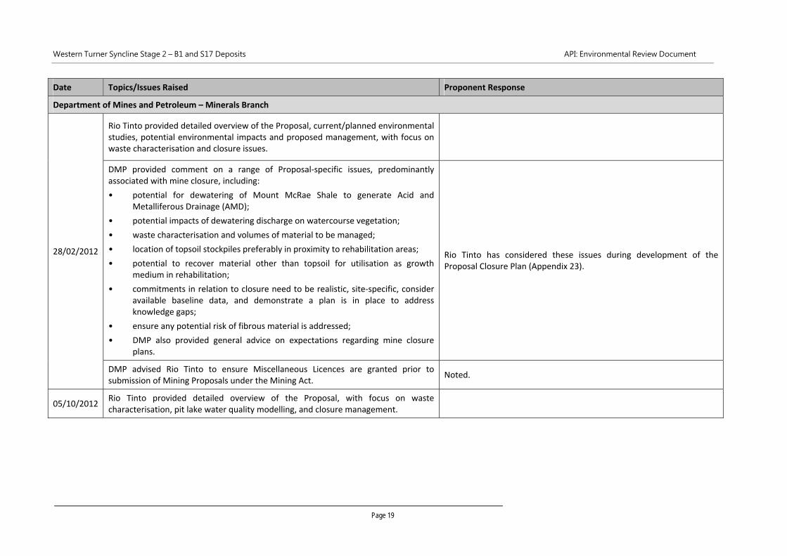
Department of Mines and Petroleum – Minerals Branch
28/02/2012
Rio Tinto provided detailed overview of the Proposal, current/planned environmental studies, potential environmental impacts and proposed management, with focus on waste characterisation and closure issues.
DMP provided comment on a range of Proposal‐specific issues, predominantly associated with mine closure, including:
• potential for dewatering of Mount McRae Shale to generate Acid and Metalliferous Drainage (AMD);
• potential impacts of dewatering discharge on watercourse vegetation;
• waste characterisation and volumes of material to be managed;
• location of topsoil stockpiles preferably in proximity to rehabilitation areas;
• potential to recover material other than topsoil for utilisation as growth medium in rehabilitation;
• commitments in relation to closure need to be realistic, site‐specific, consider available baseline data, and demonstrate a plan is in place to address knowledge gaps;
• ensure any potential risk of fibrous material is addressed;
• DMP also provided general advice on expectations regarding mine closure plans.
Rio Tinto has considered these issues during development of the Proposal Closure Plan (Appendix 23).
DMP advised Rio Tinto to ensure Miscellaneous Licences are granted prior to submission of Mining Proposals under the Mining Act.
Noted.
05/10/2012 Rio Tinto provided detailed overview of the Proposal, with focus on waste characterisation, pit lake water quality modelling, and closure management.
Western Turner Syncline Stage 2 – B1 and S17 Deposits API: Environmental Review Document
Page 20
Date Topics/Issues Raised Proponent Response
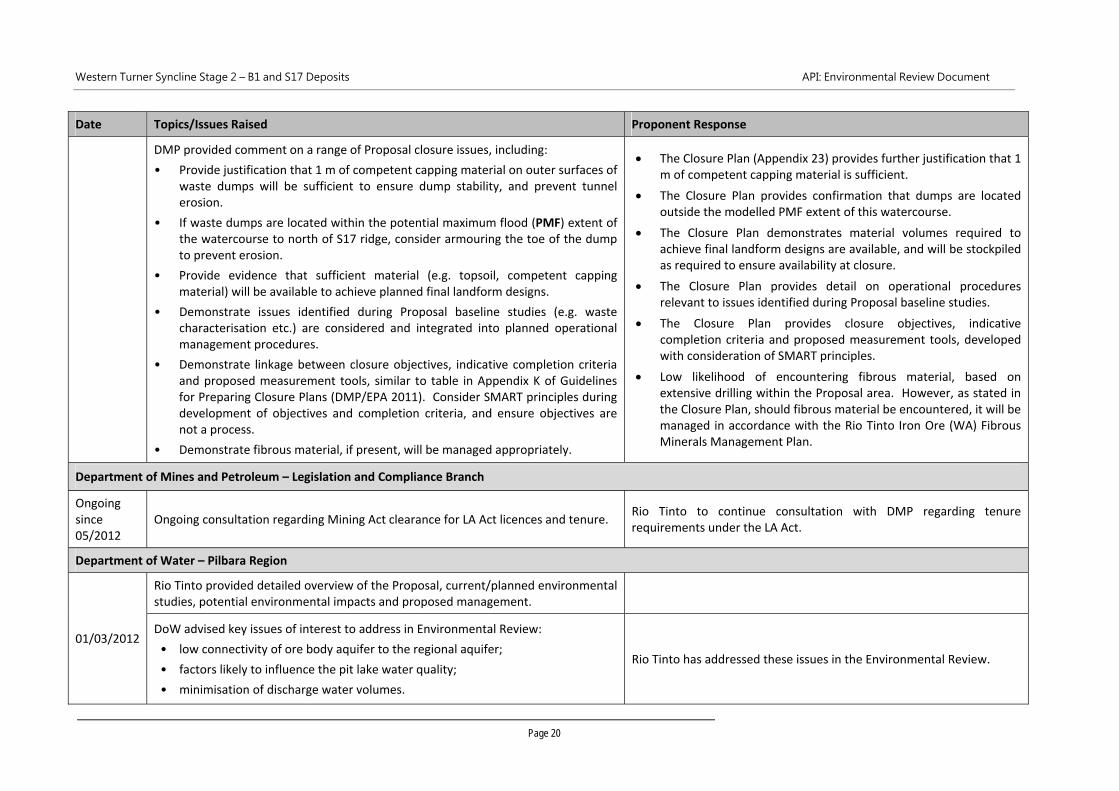
DMP provided comment on a range of Proposal closure issues, including:
• Provide justification that 1 m of competent capping material on outer surfaces of waste dumps will be sufficient to ensure dump stability, and prevent tunnel erosion.
• If waste dumps are located within the potential maximum flood (PMF) extent of the watercourse to north of S17 ridge, consider armouring the toe of the dump to prevent erosion.
• Provide evidence that sufficient material (e.g. topsoil, competent capping material) will be available to achieve planned final landform designs.
• Demonstrate issues identified during Proposal baseline studies (e.g. waste characterisation etc.) are considered and integrated into planned operational management procedures.
• Demonstrate linkage between closure objectives, indicative completion criteria and proposed measurement tools, similar to table in Appendix K of Guidelines for Preparing Closure Plans (DMP/EPA 2011). Consider SMART principles during development of objectives and completion criteria, and ensure objectives are not a process.
• Demonstrate fibrous material, if present, will be managed appropriately.
The Closure Plan (Appendix 23) provides further justification that 1 m of competent capping material is sufficient.
The Closure Plan provides confirmation that dumps are located outside the modelled PMF extent of this watercourse.
The Closure Plan demonstrates material volumes required to achieve final landform designs are available, and will be stockpiled as required to ensure availability at closure.
The Closure Plan provides detail on operational procedures relevant to issues identified during Proposal baseline studies.
The Closure Plan provides closure objectives, indicative completion criteria and proposed measurement tools, developed with consideration of SMART principles.
Low likelihood of encountering fibrous material, based on extensive drilling within the Proposal area. However, as stated in the Closure Plan, should fibrous material be encountered, it will be managed in accordance with the Rio Tinto Iron Ore (WA) Fibrous Minerals Management Plan.
Department of Mines and Petroleum – Legislation and Compliance Branch
Ongoing since 05/2012
Ongoing consultation regarding Mining Act clearance for LA Act licences and tenure. Rio Tinto to continue consultation with DMP regarding tenure requirements under the LA Act.
Department of Water – Pilbara Region
01/03/2012
Rio Tinto provided detailed overview of the Proposal, current/planned environmental studies, potential environmental impacts and proposed management.
DoW advised key issues of interest to address in Environmental Review:
• low connectivity of ore body aquifer to the regional aquifer;
• factors likely to influence the pit lake water quality;
• minimisation of discharge water volumes.
Rio Tinto has addressed these issues in the Environmental Review.

Western Turner Syncline Stage 2 – B1 and S17 Deposits API: Environmental Review Document
Page 21
Date Topics/Issues Raised Proponent Response
Department of Water – Perth Office
02/03/2012
Rio Tinto provided detailed overview of the Proposal, current/planned environmental studies, potential environmental impacts and proposed management, with focus on water management issues.
DoW indicated the proposed approach to discharge water quality management strategy was reasonable and was willing to provide further advice on draft strategy.
Rio Tinto is further developing the approach to discharge water quality management strategy and will liaise with DoW as necessary.
DoW suggested a site visit would be beneficial. A site visit was undertaken to WTS2 on 12/03/2013 with OEPA and DoW.
01/11/2012
Meeting included DEC CSB.
Rio Tinto provided overview of the Proposal, with focus on geology, hydrogeology, geochemical waste characterisation, pit lake water quality modelling, mineral waste management, and closure planning.
DoW advised approach to geochemical waste characterisation and pit lake water quality modelling was reasonable, and appropriate for the stage of the Proposal.
Acknowledged.
12/03/2013 Site visit to WTS2 with OEPA and DOW.
General discussion of relevant environmental factors and potential impacts.
Department of State Development
Ongoing since 11/2011
Rio Tinto has provided ongoing updates on the Proposal at monthly meetings with DSD.
Rio Tinto will continue consultation with DSD regarding the Proposal.
Department of Indigenous Affairs
13/12/2012 Rio Tinto discussed the Proposal and heritage matters with DIA, at a regular liaison meeting.
Rio Tinto will continue regular liaison with the DIA, and will discuss Proposal specific matters as required.
Rio Tinto will consult with DIA regarding any planned submissions for approval under s 18 of the Aboriginal Heritage Act 1972 to disturb any heritage sites.
Western Turner Syncline Stage 2 – B1 and S17 Deposits API: Environmental Review Document
Page 22
Date Topics/Issues Raised Proponent Response
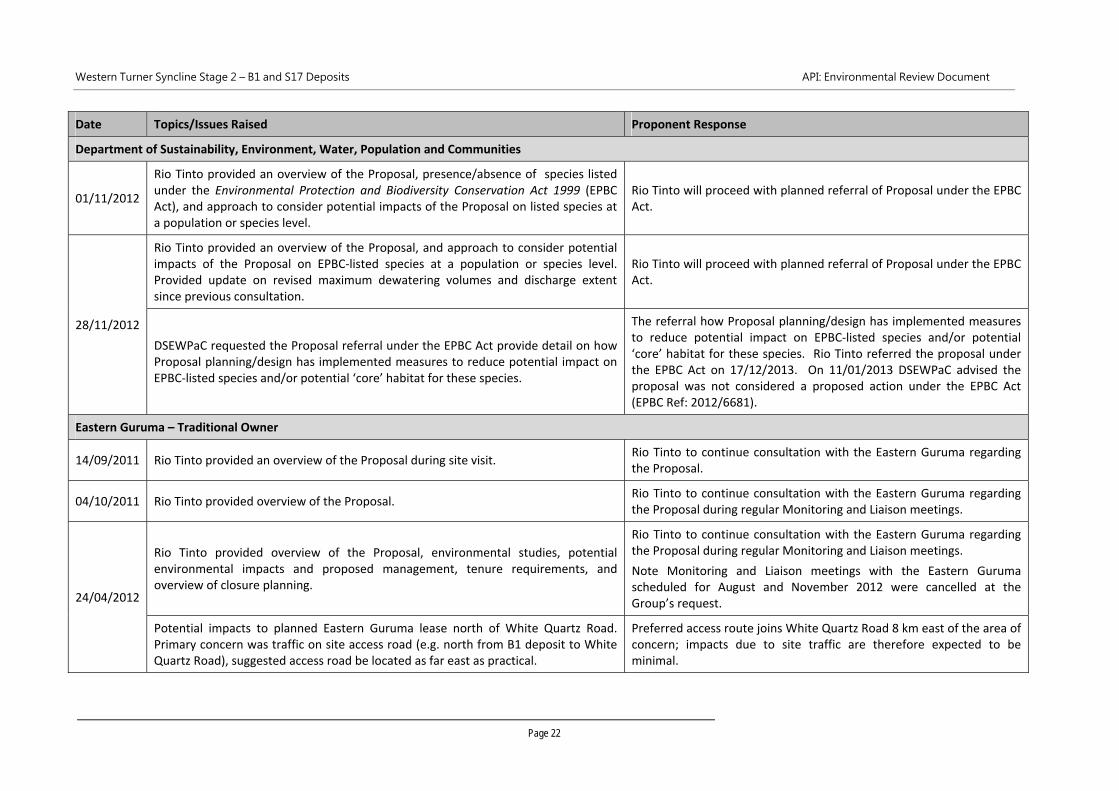
Department of Sustainability, Environment, Water, Population and Communities
01/11/2012
Rio Tinto provided an overview of the Proposal, presence/absence of species listed under the Environmental Protection and Biodiversity Conservation Act 1999 (EPBC Act), and approach to consider potential impacts of the Proposal on listed species at a population or species level.
Rio Tinto will proceed with planned referral of Proposal under the EPBC Act.
28/11/2012
Rio Tinto provided an overview of the Proposal, and approach to consider potential impacts of the Proposal on EPBC‐listed species at a population or species level. Provided update on revised maximum dewatering volumes and discharge extent since previous consultation.
Rio Tinto will proceed with planned referral of Proposal under the EPBC Act.
DSEWPaC requested the Proposal referral under the EPBC Act provide detail on how Proposal planning/design has implemented measures to reduce potential impact on EPBC‐listed species and/or potential ‘core’ habitat for these species.
The referral how Proposal planning/design has implemented measures to reduce potential impact on EPBC‐listed species and/or potential ‘core’ habitat for these species. Rio Tinto referred the proposal under the EPBC Act on 17/12/2013. On 11/01/2013 DSEWPaC advised the proposal was not considered a proposed action under the EPBC Act (EPBC Ref: 2012/6681).
Eastern Guruma – Traditional Owner
14/09/2011 Rio Tinto provided an overview of the Proposal during site visit. Rio Tinto to continue consultation with the Eastern Guruma regarding the Proposal.
04/10/2011 Rio Tinto provided overview of the Proposal. Rio Tinto to continue consultation with the Eastern Guruma regarding the Proposal during regular Monitoring and Liaison meetings.
24/04/2012
Rio Tinto provided overview of the Proposal, environmental studies, potential environmental impacts and proposed management, tenure requirements, and overview of closure planning.
Rio Tinto to continue consultation with the Eastern Guruma regarding the Proposal during regular Monitoring and Liaison meetings.
Note Monitoring and Liaison meetings with the Eastern Guruma scheduled for August and November 2012 were cancelled at the Group’s request.
Potential impacts to planned Eastern Guruma lease north of White Quartz Road. Primary concern was traffic on site access road (e.g. north from B1 deposit to White Quartz Road), suggested access road be located as far east as practical.
Preferred access route joins White Quartz Road 8 km east of the area of concern; impacts due to site traffic are therefore expected to be minimal.
Western Turner Syncline Stage 2 – B1 and S17 Deposits API: Environmental Review Document
Page 23
Date Topics/Issues Raised Proponent Response
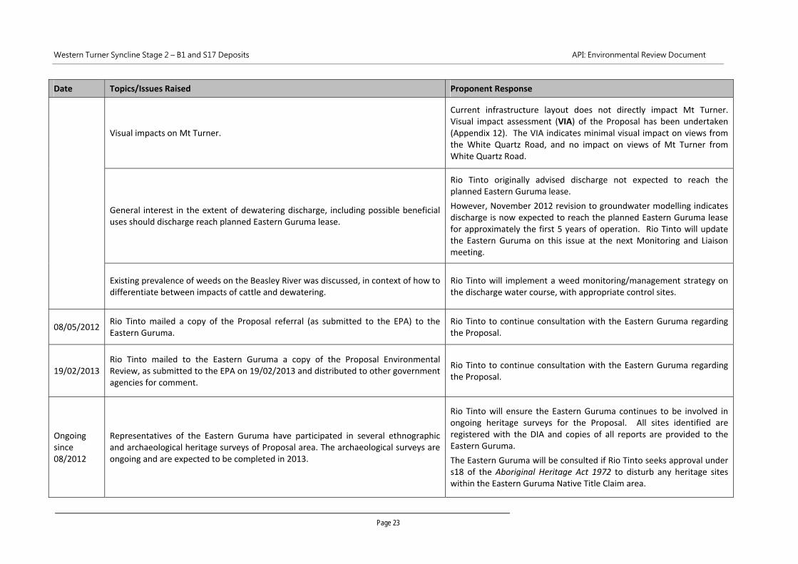
Visual impacts on Mt Turner.
Current infrastructure layout does not directly impact Mt Turner. Visual impact assessment (VIA) of the Proposal has been undertaken (Appendix 12). The VIA indicates minimal visual impact on views from the White Quartz Road, and no impact on views of Mt Turner from White Quartz Road.
General interest in the extent of dewatering discharge, including possible beneficial uses should discharge reach planned Eastern Guruma lease.
Rio Tinto originally advised discharge not expected to reach the planned Eastern Guruma lease.
However, November 2012 revision to groundwater modelling indicates discharge is now expected to reach the planned Eastern Guruma lease for approximately the first 5 years of operation. Rio Tinto will update the Eastern Guruma on this issue at the next Monitoring and Liaison meeting.
Existing prevalence of weeds on the Beasley River was discussed, in context of how to differentiate between impacts of cattle and dewatering.
Rio Tinto will implement a weed monitoring/management strategy on the discharge water course, with appropriate control sites.
08/05/2012 Rio Tinto mailed a copy of the Proposal referral (as submitted to the EPA) to the Eastern Guruma.
Rio Tinto to continue consultation with the Eastern Guruma regarding the Proposal.
19/02/2013 Rio Tinto mailed to the Eastern Guruma a copy of the Proposal Environmental Review, as submitted to the EPA on 19/02/2013 and distributed to other government agencies for comment.
Rio Tinto to continue consultation with the Eastern Guruma regarding the Proposal.
Ongoing since 08/2012
Representatives of the Eastern Guruma have participated in several ethnographic and archaeological heritage surveys of Proposal area. The archaeological surveys are ongoing and are expected to be completed in 2013.
Rio Tinto will ensure the Eastern Guruma continues to be involved in ongoing heritage surveys for the Proposal. All sites identified are registered with the DIA and copies of all reports are provided to the Eastern Guruma.
The Eastern Guruma will be consulted if Rio Tinto seeks approval under s18 of the Aboriginal Heritage Act 1972 to disturb any heritage sites within the Eastern Guruma Native Title Claim area.
Western Turner Syncline Stage 2 – B1 and S17 Deposits API: Environmental Review Document
Page 24
Date Topics/Issues Raised Proponent Response
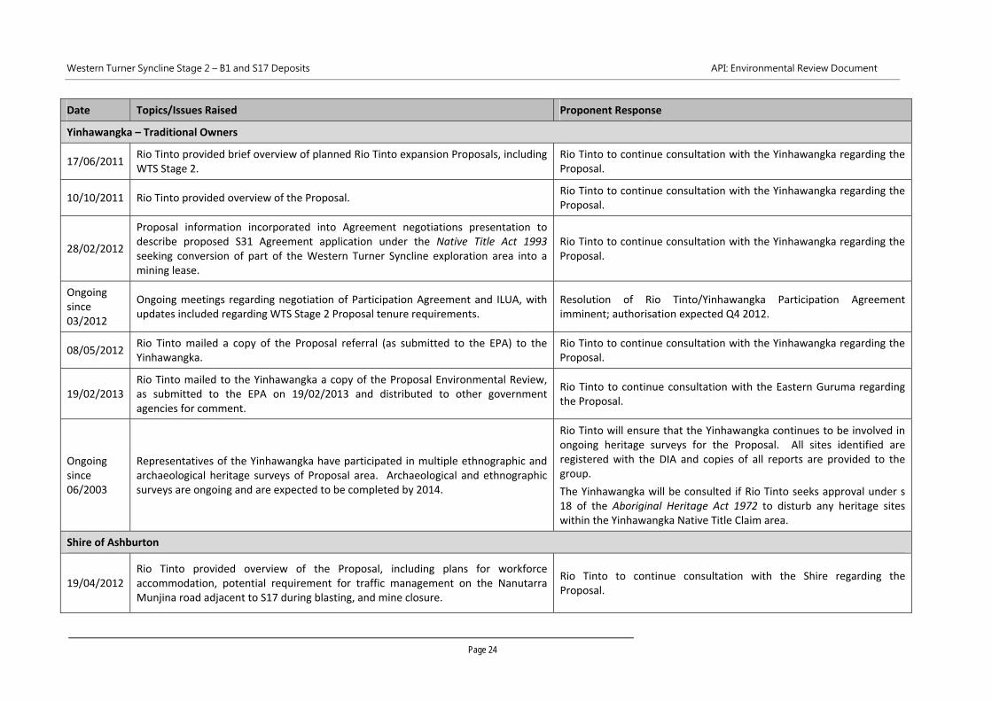
Yinhawangka – Traditional Owners
17/06/2011 Rio Tinto provided brief overview of planned Rio Tinto expansion Proposals, including WTS Stage 2.
Rio Tinto to continue consultation with the Yinhawangka regarding the Proposal.
10/10/2011 Rio Tinto provided overview of the Proposal. Rio Tinto to continue consultation with the Yinhawangka regarding the Proposal.
28/02/2012
Proposal information incorporated into Agreement negotiations presentation to describe proposed S31 Agreement application under the Native Title Act 1993 seeking conversion of part of the Western Turner Syncline exploration area into a mining lease.
Rio Tinto to continue consultation with the Yinhawangka regarding the Proposal.
Ongoing since 03/2012
Ongoing meetings regarding negotiation of Participation Agreement and ILUA, with updates included regarding WTS Stage 2 Proposal tenure requirements.
Resolution of Rio Tinto/Yinhawangka Participation Agreement imminent; authorisation expected Q4 2012.
08/05/2012 Rio Tinto mailed a copy of the Proposal referral (as submitted to the EPA) to the Yinhawangka.
Rio Tinto to continue consultation with the Yinhawangka regarding the Proposal.
19/02/2013 Rio Tinto mailed to the Yinhawangka a copy of the Proposal Environmental Review, as submitted to the EPA on 19/02/2013 and distributed to other government agencies for comment.
Rio Tinto to continue consultation with the Eastern Guruma regarding the Proposal.
Ongoing since 06/2003
Representatives of the Yinhawangka have participated in multiple ethnographic and archaeological heritage surveys of Proposal area. Archaeological and ethnographic surveys are ongoing and are expected to be completed by 2014.
Rio Tinto will ensure that the Yinhawangka continues to be involved in ongoing heritage surveys for the Proposal. All sites identified are registered with the DIA and copies of all reports are provided to the group.
The Yinhawangka will be consulted if Rio Tinto seeks approval under s 18 of the Aboriginal Heritage Act 1972 to disturb any heritage sites within the Yinhawangka Native Title Claim area.
Shire of Ashburton
19/04/2012 Rio Tinto provided overview of the Proposal, including plans for workforce accommodation, potential requirement for traffic management on the Nanutarra Munjina road adjacent to S17 during blasting, and mine closure.
Rio Tinto to continue consultation with the Shire regarding the Proposal.
Western Turner Syncline Stage 2 – B1 and S17 Deposits API: Environmental Review Document
Page 25
Date Topics/Issues Raised Proponent Response
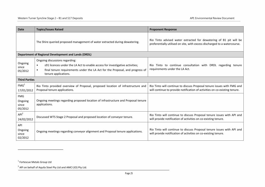
The Shire queried proposed management of water extracted during dewatering. Rio Tinto advised water extracted for dewatering of B1 pit will be preferentially utilised on site, with excess discharged to a watercourse.
Department of Regional Development and Lands (DRDL)
Ongoing since 05/2012
Ongoing discussions regarding:
• s91 licences under the LA Act to enable access for investigative activities;
• final tenure requirements under the LA Act for the Proposal, and progress of tenure applications.
Rio Tinto to continue consultation with DRDL regarding tenure requirements under the LA Act.
Third Parties
FMG1
17/01/2012
Rio Tinto provided overview of Proposal, proposed location of infrastructure and Proposal tenure applications.
Rio Tinto will continue to discuss Proposal tenure issues with FMG and will continue to provide notification of activities on co‐existing tenure.
FMG
Ongoing since 05/2012
Ongoing meetings regarding proposed location of infrastructure and Proposal tenure applications.
API2
24/02/2012 Discussed WTS Stage 2 Proposal and proposed location of conveyor tenure.
Rio Tinto will continue to discuss Proposal tenure issues with API and will provide notification of activities on co‐existing tenure.
API
Ongoing since 02/2012
Ongoing meetings regarding conveyor alignment and Proposal tenure applications. Rio Tinto will continue to discuss Proposal tenure issues with API and will provide notification of activities on co‐existing tenure.
1 Fortescue Metals Group Ltd
2 API on behalf of Aquila Steel Pty Ltd and AMCI (IO) Pty Ltd.

Western Turner Syncline Stage 2 – B1 and S17 Deposits API: Environmental Review Document
Page 26
Western Turner Syncline Stage 2 – B1 and S17 Deposits API: Environmental Review Document
Page 27
3 ENVIRONMENTAL IMPACTS AND MANAGEMENT
3.1 Environmental Impacts and Management
The EPA‐prepared ESD, for the Proposal, identified the following preliminary key environmental factors:
• vegetation and flora;
• fauna (terrestrial, subterranean and aquatic);
• ground and surface water;
• rehabilitation and mine closure;
• residual impacts.
In accordance with the new framework for the EPA’s principles for environmental protection, the
preliminary key environmental factors are identified as:
• flora and vegetation;
• terrestrial fauna and subterranean fauna;
• hydrological processes and inland waters environmental quality;
• rehabilitation and closure;
• residual impacts.
Studies and surveys utilised to support the impact assessment are summarised in Table 3‐1.
Environmental impacts and management of the preliminary key environmental factors are addressed in a
series of Tables (Table 3‐2 to Table 3‐9).
The assessment of impacts and management of other factors is presented in Section 4 (Table 4‐1).
3.2 Environmental Management Overview
Rio Tinto has developed and refined environmental management policies, systems and procedures over
decades of operational mining experience in the Pilbara region that are successfully applied at multiple iron
ore mine sites.
The key components to be implemented during the WTS Stage 2 Proposal include:
1. The Rio Tinto Iron Ore group Health, Safety, Environment, Communities and Quality Policy (HSECQ
Policy). The HSECQ Policy is the guiding document for environmental management and provides
context and direction for continuous improvement.
2. Rio Tinto Iron Ore (WA) operates under an ISO14001 certified Environmental Management System
(EMS), contained within the Health, Safety, Environment and Quality (HSEQ) Management System.
The HSEQ Management System is a continuous improvement model covering:
systematic assessment of environmental risk and legal requirements;
systems for training, operational control, communication, emergency response and corrective
actions;
the development of objectives and targets for improvement;
audits and review.
Western Turner Syncline Stage 2 – B1 and S17 Deposits API: Environmental Review Document
Page 28
3. A Construction Environmental Management Plan (CEMP), that will interface with the HSEQ
Management System.
4. An operational Environmental Management Plan (EMP) that will interface with the HSEQ
Management System.
5. The Rio Tinto Closure Standard will continue to guide Proposal closure planning and implementation,
addressing the development of a Closure Knowledge Base, developing and maintaining a Closure
Strategy, developing and maintaining a Closure Management Plan, stakeholder consultation,
financial provisioning for closure, reviews of closure plans on a regular basis, and developing a final
decommissioning plan five years prior to scheduled closure.
6. The Rio Tinto Iron Ore (WA) Significant Species Management Plan (SSMP), which provides the
framework for Rio Tinto to minimise impacts to Pilbara populations of species listed under the
Environment Protection and Biodiversity Conservation Act 1999 (EPBC Act) from activities associated
with expansions to its iron ore mining operations. The SSMP includes standard management
measures to minimise impacts to Matters of National Environmental Significance (MNES), and
requires development of further site‐specific management measures where species of MNES occur,
or are likely to occur, in proximity to expansion projects in the Pilbara.
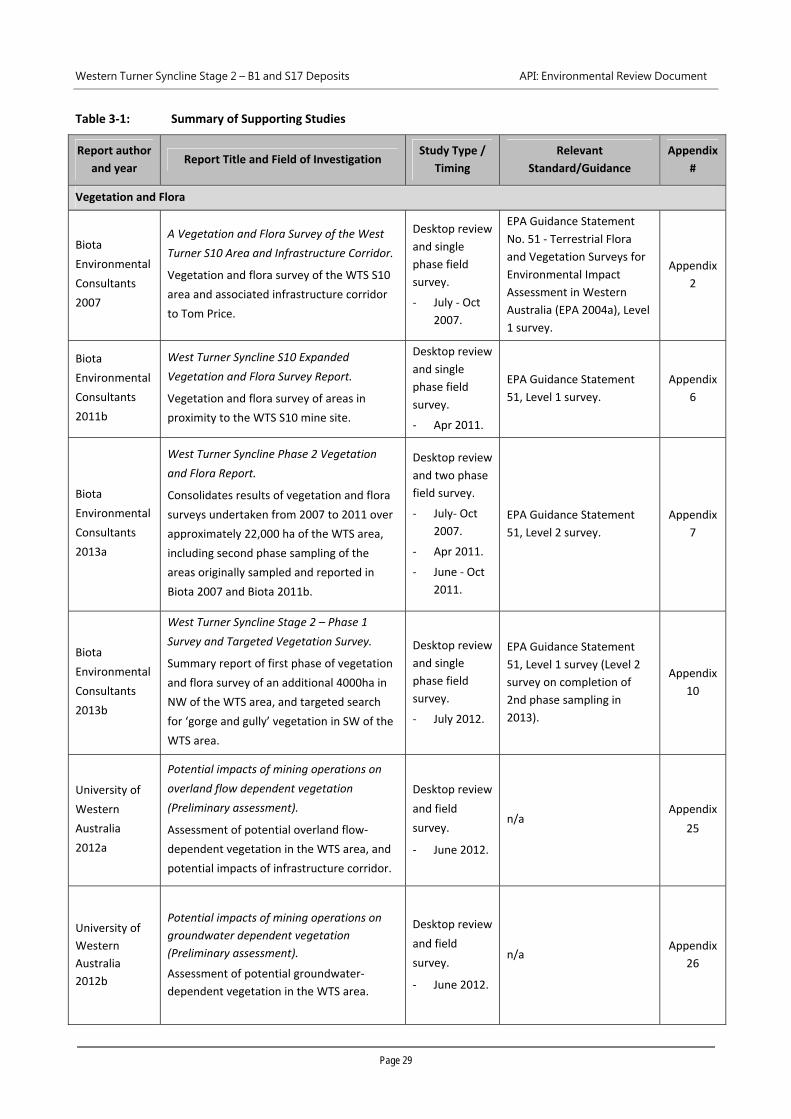
Western Turner Syncline Stage 2 – B1 and S17 Deposits API: Environmental Review Document
Page 29
Table 3‐1: Summary of Supporting Studies
Report author
and year Report Title and Field of Investigation
Study Type /
Timing
Relevant
Standard/Guidance
Appendix
#
Vegetation and Flora
Biota
Environmental
Consultants
2007
A Vegetation and Flora Survey of the West
Turner S10 Area and Infrastructure Corridor.
Vegetation and flora survey of the WTS S10
area and associated infrastructure corridor
to Tom Price.
Desktop review
and single
phase field
survey.
‐ July ‐ Oct
2007.
EPA Guidance Statement
No. 51 ‐ Terrestrial Flora
and Vegetation Surveys for
Environmental Impact
Assessment in Western
Australia (EPA 2004a), Level
1 survey.
Appendix
2
Biota
Environmental
Consultants
2011b
West Turner Syncline S10 Expanded
Vegetation and Flora Survey Report.
Vegetation and flora survey of areas in
proximity to the WTS S10 mine site.
Desktop review
and single
phase field
survey.
‐ Apr 2011.
EPA Guidance Statement
51, Level 1 survey.
Appendix
6
Biota
Environmental
Consultants
2013a
West Turner Syncline Phase 2 Vegetation
and Flora Report.
Consolidates results of vegetation and flora
surveys undertaken from 2007 to 2011 over
approximately 22,000 ha of the WTS area,
including second phase sampling of the
areas originally sampled and reported in
Biota 2007 and Biota 2011b.
Desktop review
and two phase
field survey.
‐ July‐ Oct
2007.
‐ Apr 2011.
‐ June ‐ Oct
2011.
EPA Guidance Statement
51, Level 2 survey.
Appendix
7
Biota
Environmental
Consultants
2013b
West Turner Syncline Stage 2 – Phase 1
Survey and Targeted Vegetation Survey.
Summary report of first phase of vegetation
and flora survey of an additional 4000ha in
NW of the WTS area, and targeted search
for ‘gorge and gully’ vegetation in SW of the
WTS area.
Desktop review
and single
phase field
survey.
‐ July 2012.
EPA Guidance Statement
51, Level 1 survey (Level 2
survey on completion of
2nd phase sampling in
2013).
Appendix
10
University of
Western
Australia
2012a
Potential impacts of mining operations on
overland flow dependent vegetation
(Preliminary assessment).
Assessment of potential overland flow‐
dependent vegetation in the WTS area, and
potential impacts of infrastructure corridor.
Desktop review
and field
survey.
‐ June 2012.
n/a Appendix
25
University of
Western
Australia
2012b
Potential impacts of mining operations on
groundwater dependent vegetation
(Preliminary assessment).
Assessment of potential groundwater‐
dependent vegetation in the WTS area.
Desktop review
and field
survey.
‐ June 2012.
n/a Appendix
26
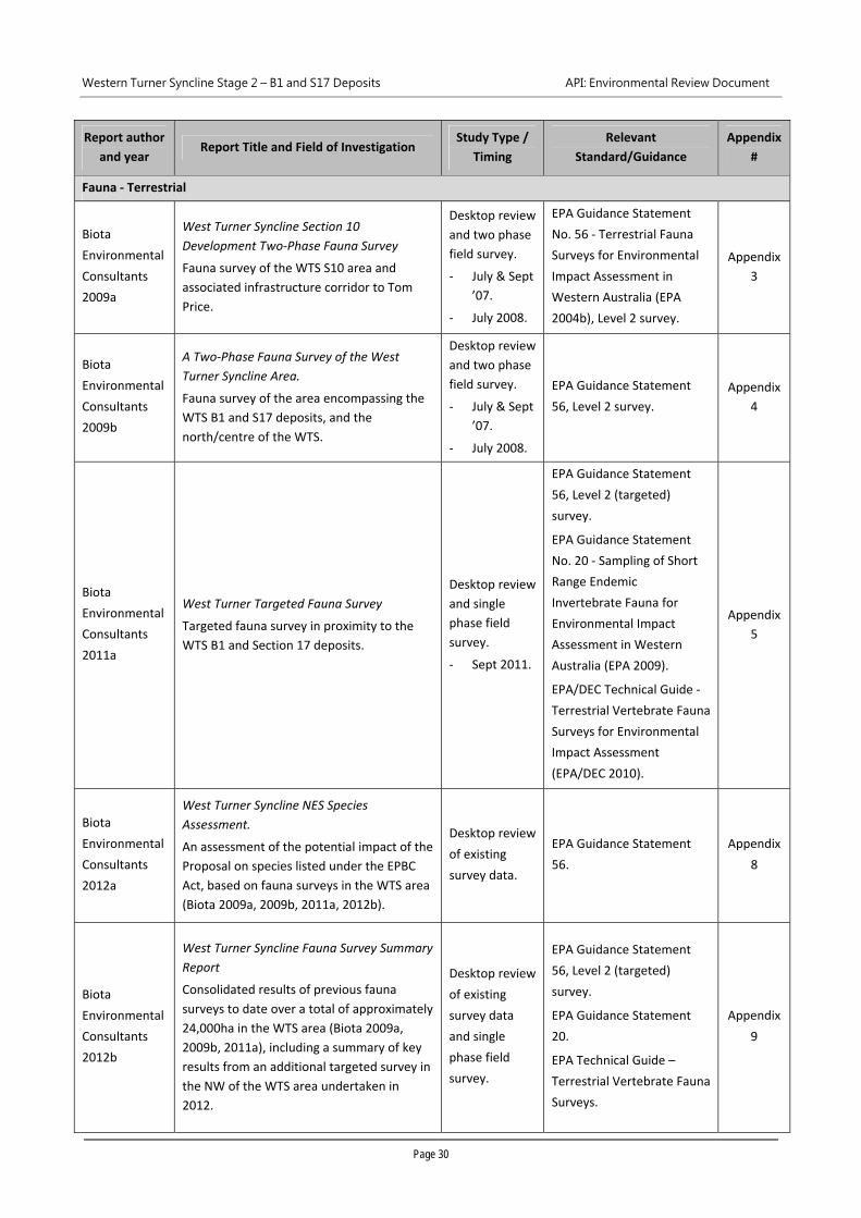
Western Turner Syncline Stage 2 – B1 and S17 Deposits API: Environmental Review Document
Page 30
Report author
and year Report Title and Field of Investigation
Study Type /
Timing
Relevant
Standard/Guidance
Appendix
#
Fauna ‐ Terrestrial
Biota
Environmental
Consultants
2009a
West Turner Syncline Section 10
Development Two‐Phase Fauna Survey
Fauna survey of the WTS S10 area and
associated infrastructure corridor to Tom
Price.
Desktop review
and two phase
field survey.
‐ July & Sept
’07.
‐ July 2008.
EPA Guidance Statement
No. 56 ‐ Terrestrial Fauna
Surveys for Environmental
Impact Assessment in
Western Australia (EPA
2004b), Level 2 survey.
Appendix
3
Biota
Environmental
Consultants
2009b
A Two‐Phase Fauna Survey of the West
Turner Syncline Area.
Fauna survey of the area encompassing the
WTS B1 and S17 deposits, and the
north/centre of the WTS.
Desktop review
and two phase
field survey.
‐ July & Sept
’07.
‐ July 2008.
EPA Guidance Statement
56, Level 2 survey.
Appendix
4
Biota
Environmental
Consultants
2011a
West Turner Targeted Fauna Survey
Targeted fauna survey in proximity to the
WTS B1 and Section 17 deposits.
Desktop review
and single
phase field
survey.
‐ Sept 2011.
EPA Guidance Statement
56, Level 2 (targeted)
survey.
EPA Guidance Statement
No. 20 ‐ Sampling of Short
Range Endemic
Invertebrate Fauna for
Environmental Impact
Assessment in Western
Australia (EPA 2009).
EPA/DEC Technical Guide ‐
Terrestrial Vertebrate Fauna
Surveys for Environmental
Impact Assessment
(EPA/DEC 2010).
Appendix
5
Biota
Environmental
Consultants
2012a
West Turner Syncline NES Species
Assessment.
An assessment of the potential impact of the
Proposal on species listed under the EPBC
Act, based on fauna surveys in the WTS area
(Biota 2009a, 2009b, 2011a, 2012b).
Desktop review
of existing
survey data.
EPA Guidance Statement
56.
Appendix
8
Biota
Environmental
Consultants
2012b
West Turner Syncline Fauna Survey Summary
Report
Consolidated results of previous fauna
surveys to date over a total of approximately
24,000ha in the WTS area (Biota 2009a,
2009b, 2011a), including a summary of key
results from an additional targeted survey in
the NW of the WTS area undertaken in
2012.
Desktop review
of existing
survey data
and single
phase field
survey.
EPA Guidance Statement
56, Level 2 (targeted)
survey.
EPA Guidance Statement
20.
EPA Technical Guide –
Terrestrial Vertebrate Fauna
Surveys.
Appendix
9
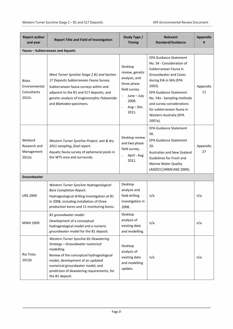
Western Turner Syncline Stage 2 – B1 and S17 Deposits API: Environmental Review Document
Page 31
Report author
and year Report Title and Field of Investigation
Study Type /
Timing
Relevant
Standard/Guidance
Appendix
#
Fauna – Subterranean and Aquatic
Biota
Environmental
Consultants
2012c
West Turner Syncline Stage 2 B1 and Section
17 Deposits Subterranean Fauna Survey.
Subterranean fauna surveys within and
adjacent to the B1 and S17 deposits, and
genetic analysis of troglomorphic Polyxenida
and Blattodea specimens.
Desktop
review, genetic
analysis, and
three phase
field survey.
‐ June – July
2009.
‐ Aug – Dec
2011.
EPA Guidance Statement
No. 54 ‐ Consideration of
Subterranean Fauna in
Groundwater and Caves
during EIA in WA (EPA
2003).
EPA Guidance Statement
No. 54a ‐ Sampling methods
and survey considerations
for subterranean fauna in
Western Australia (EPA
2007a).
Appendix
11
Wetland
Research and
Management
2012a
Western Turner Syncline Project, wet & dry
2011 sampling, final report.
Aquatic fauna survey of ephemeral pools in
the WTS area and surrounds.
Desktop review
and two phase
field survey.
‐ April ‐ Aug
2011.
EPA Guidance Statement
56.
EPA Guidance Statement
20.
Australian and New Zealand
Guidelines for Fresh and
Marine Water Quality
(ANZECC/ARMCANZ 2000).
Appendix
27
Groundwater
URS 2009
Western Turner Syncline Hydrogeological
Bore Completion Report.
Hydrogeological drilling investigation at B1
in 2008, including installation of three
production bores and 11 monitoring bores.
Desktop
analysis and
field drilling
investigation in
2008.
n/a n/a
MWH 2009
B1 groundwater model.
Development of a conceptual
hydrogeological model and a numeric
groundwater model for the B1 deposit.
Desktop
analysis of
existing data
and modelling.
n/a n/a
Rio Tinto
2012b
Western Turner Syncline B1 Dewatering
Strategy – Groundwater numerical
modelling.
Review of the conceptual hydrogeological
model, development of an updated
numerical groundwater model, and
prediction of dewatering requirements, for
the B1 deposit.
Desktop
analysis of
existing data
and modelling
update.
n/a n/a
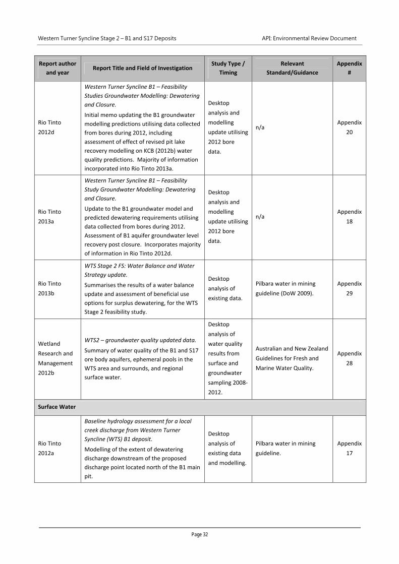
Western Turner Syncline Stage 2 – B1 and S17 Deposits API: Environmental Review Document
Page 32
Report author
and year Report Title and Field of Investigation
Study Type /
Timing
Relevant
Standard/Guidance
Appendix
#
Rio Tinto
2012d
Western Turner Syncline B1 – Feasibility
Studies Groundwater Modelling: Dewatering
and Closure.
Initial memo updating the B1 groundwater
modelling predictions utilising data collected
from bores during 2012, including
assessment of effect of revised pit lake
recovery modelling on KCB (2012b) water
quality predictions. Majority of information
incorporated into Rio Tinto 2013a.
Desktop
analysis and
modelling
update utilising
2012 bore
data.
n/a Appendix
20
Rio Tinto
2013a
Western Turner Syncline B1 – Feasibility
Study Groundwater Modelling: Dewatering
and Closure.
Update to the B1 groundwater model and
predicted dewatering requirements utilising
data collected from bores during 2012.
Assessment of B1 aquifer groundwater level
recovery post closure. Incorporates majority
of information in Rio Tinto 2012d.
Desktop
analysis and
modelling
update utilising
2012 bore
data.
n/a Appendix
18
Rio Tinto
2013b
WTS Stage 2 FS: Water Balance and Water
Strategy update.
Summarises the results of a water balance
update and assessment of beneficial use
options for surplus dewatering, for the WTS
Stage 2 feasibility study.
Desktop
analysis of
existing data.
Pilbara water in mining
guideline (DoW 2009).
Appendix
29
Wetland
Research and
Management
2012b
WTS2 – groundwater quality updated data.
Summary of water quality of the B1 and S17
ore body aquifers, ephemeral pools in the
WTS area and surrounds, and regional
surface water.
Desktop
analysis of
water quality
results from
surface and
groundwater
sampling 2008‐
2012.
Australian and New Zealand
Guidelines for Fresh and
Marine Water Quality.
Appendix
28
Surface Water
Rio Tinto
2012a
Baseline hydrology assessment for a local
creek discharge from Western Turner
Syncline (WTS) B1 deposit.
Modelling of the extent of dewatering
discharge downstream of the proposed
discharge point located north of the B1 main
pit.
Desktop
analysis of
existing data
and modelling.
Pilbara water in mining
guideline.
Appendix
17
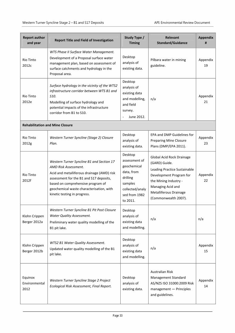
Western Turner Syncline Stage 2 – B1 and S17 Deposits API: Environmental Review Document
Page 33
Report author
and year Report Title and Field of Investigation
Study Type /
Timing
Relevant
Standard/Guidance
Appendix
#
Rio Tinto
2012c
WTS Phase II Surface Water Management.
Development of a Proposal surface water
management plan, based on assessment of
surface catchments and hydrology in the
Proposal area.
Desktop
analysis of
existing data.
Pilbara water in mining
guideline.
Appendix
19
Rio Tinto
2012e
Surface hydrology in the vicinity of the WTS2
infrastructure corridor between WTS B1 and
S10.
Modelling of surface hydrology and
potential impacts of the infrastructure
corridor from B1 to S10.
Desktop
analysis of
existing data
and modelling,
and field
survey.
‐ June 2012.
n/a Appendix
21
Rehabilitation and Mine Closure
Rio Tinto
2012g
Western Turner Syncline (Stage 2) Closure
Plan.
Desktop
analysis of
existing data.
EPA and DMP Guidelines for
Preparing Mine Closure
Plans (DMP/EPA 2011).
Appendix
23
Rio Tinto
2012f
Western Turner Syncline B1 and Section 17
AMD Risk Assessment.
Acid and metalliferous drainage (AMD) risk
assessment for the B1 and S17 deposits,
based on comprehensive program of
geochemical waste characterisation, with
kinetic testing in progress.
Desktop
assessment of
geochemical
data, from
drilling
samples
collected/analy
sed from 1982
to 2011.
Global Acid Rock Drainage
(GARD) Guide.
Leading Practice Sustainable
Development Program for
the Mining Industry ‐
Managing Acid and
Metalliferous Drainage
(Commonwealth 2007).
Appendix
22
Klohn Crippen
Berger 2012a
Western Turner Syncline B1 Pit Post Closure
Water Quality Assessment.
Preliminary water quality modelling of the
B1 pit lake.
Desktop
analysis of
existing data
and modelling.
n/a n/a
Klohn Crippen
Berger 2012b
WTS2 B1 Water Quality Assessment.
Updated water quality modelling of the B1
pit lake.
Desktop
analysis of
existing data
and modelling.
n/a Appendix
15
Equinox
Environmental
2012
Western Turner Syncline Stage 2 Project
Ecological Risk Assessment, Final Report.
Desktop
analysis of
existing data.
Australian Risk
Management Standard
AS/NZS ISO 31000:2009 Risk
management — Principles
and guidelines.
Appendix
14
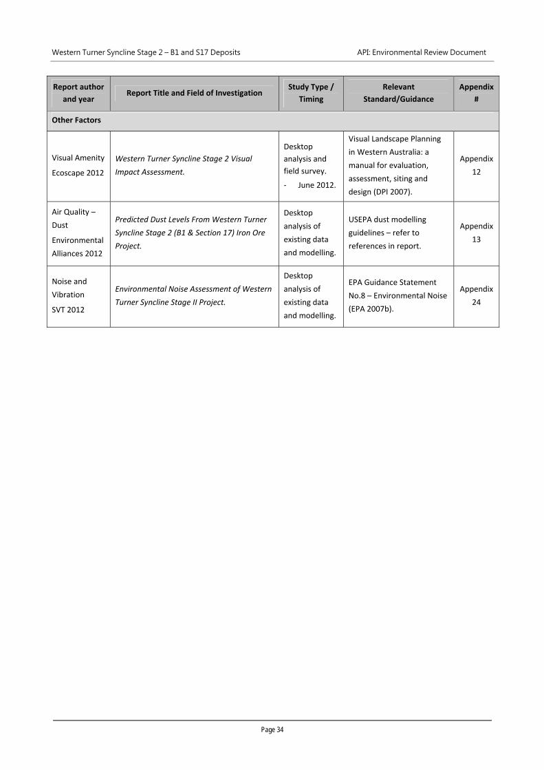
Western Turner Syncline Stage 2 – B1 and S17 Deposits API: Environmental Review Document
Page 34
Report author
and year Report Title and Field of Investigation
Study Type /
Timing
Relevant
Standard/Guidance
Appendix
#
Other Factors
Visual Amenity
Ecoscape 2012
Western Turner Syncline Stage 2 Visual
Impact Assessment.
Desktop
analysis and
field survey.
‐ June 2012.
Visual Landscape Planning
in Western Australia: a
manual for evaluation,
assessment, siting and
design (DPI 2007).
Appendix
12
Air Quality –
Dust
Environmental
Alliances 2012
Predicted Dust Levels From Western Turner
Syncline Stage 2 (B1 & Section 17) Iron Ore
Project.
Desktop
analysis of
existing data
and modelling.
USEPA dust modelling
guidelines – refer to
references in report.
Appendix
13
Noise and
Vibration
SVT 2012
Environmental Noise Assessment of Western
Turner Syncline Stage II Project.
Desktop
analysis of
existing data
and modelling.
EPA Guidance Statement
No.8 – Environmental Noise
(EPA 2007b).
Appendix
24
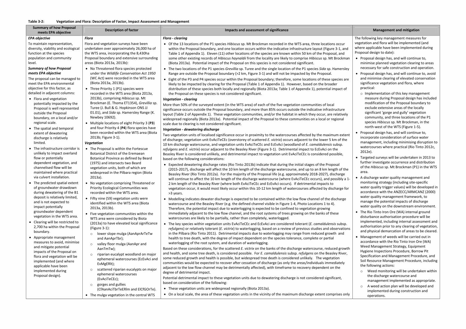
Table 3‐2: Vegetation and Flora: Description of Factor, Impact Assessment and Management
Summary of how Proposal meets EPA objective
Description of factor Impacts and assessment of significance Management and mitigation
EPA objective To maintain representation, diversity, viability and ecological function at the species population and community level.
Summary of how Proposal meets EPA objective The proposal can be managed to meet the EPA environmental objective for this factor, as detailed in adjacent columns:
Flora and vegetation potentially impacted by the Proposal is well represented outside the Proposal boundary, on a local and/or regional scale.
The spatial and temporal extent of dewatering discharge is relatively limited.
The infrastructure corridor is unlikely to impact overland flow or potentially dependent vegetation, and channelised flow will be maintained where practical via culvert installation.
The predicted spatial extent of groundwater drawdown during dewatering of the B1 deposit is relatively limited, and is not expected to impact potentially groundwater dependent vegetation in the WTS area.
Clearing will be restricted to 2,700 ha within the Proposal boundary.
Appropriate management measures to avoid, minimise and mitigate potential impacts of the Proposal on flora and vegetation will be implemented (and where applicable have been implemented during Proposal design).
Flora Flora and vegetation surveys have been undertaken over approximately 26,000 ha of the WTS area, incorporating the 8,430ha Proposal boundary and extensive surrounding areas (Biota 2013a, 2013b):
No Threatened flora species protected under the Wildlife Conservation Act 1950 (WC Act) were recorded in the WTS area (Biota 2013a, 2013b).
Three Priority 1 (P1) species were recorded in the WTS area (Biota 2013a, 2013b), comprising Hibiscus sp. Mt Brockman (E. Thoma ET1354), Grevillia sp. Turee (J. Bull & G. Hopkinson ONS JJ 01.01), and Sida sp. Hamersley Range (K. Newbey 10692).
Multiple locations of eight Priority 3 (P3) and four Priority 4 (P4) flora species have been recorded within the WTS area (Biota 2013b; Figure 3‐1).
Vegetation The Proposal is within the Fortescue
Botanical District of the Eremaean Botanical Province as defined by Beard (1975) and intersects two Beard vegetation units, both of which are widespread in the Pilbara region (Biota 2013a).
No vegetation comprising Threatened or Priority Ecological Communities was recorded within the WTS area.
Fifty nine (59) vegetation units were identified within the WTS area (Biota 2013a, 2013b).
Five vegetation communities within the WTS area were considered by Biota (2013a) to have elevated local significance (Figure 3‐1):
o lower slope mulga (AanAprArTeTw and AanAprTbr);
o valley floor mulga (AanApr and AanTmTw);
o riparian eucalypt woodland on major ephemeral watercourses (EcEvAci and EvMgERlt);
o scattered riparian eucalypts on major ephemeral watercourses (EvAciTeCEc);
o gorges and gullies (CfAanAciTbrTeERlm and ElCfGOrTe).
The mulga vegetation in the central WTS
Flora ‐ clearing Of the 13 locations of the P1 species Hibiscus sp. Mt Brockman recorded in the WTS area, three locations occur
within the Proposal boundary, and one location occurs within the indicative infrastructure layout (Figure 3‐1, and Table 1 of Appendix 1). Eleven (11) other locations of the species are known within 50 km of the Proposal, and some other existing records of Hibiscus haynaldii from the locality are likely to comprise Hibiscus sp. Mt Brockman (Biota 2013a). Potential impact of the Proposal on this species is not considered significant.
The two locations of the P1 species Grevillia sp. Turee and the single location of the P1 species Sida sp. Hamersley Range are outside the Proposal boundary (>2 km, Figure 3‐1) and will not be impacted by the Proposal.
Eight of the P3 and P4 species occur within the Proposal boundary; therefore, some locations of these species are likely to be impacted by clearing for the Proposal (Table 1 of Appendix 1). However, based on the broader distribution of these species both locally and regionally (Biota 2013a; Table 1 of Appendix 1), potential impact of the Proposal on these species is not considered significant.
Vegetation ‐ clearing More than 50% of the surveyed extent (in the WTS area) of each of the five vegetation communities of local significance occurs outside the Proposal boundary, and more than 85% occurs outside the indicative infrastructure layout (Table 2 of Appendix 1). These vegetation communities, and/or the habitat in which they occur, are relatively widespread regionally (Biota 2013a). Potential impact of the Proposal to these communities on a local or regional scale due to clearing is not considered significant.
Vegetation ‐ dewatering discharge Two vegetation units of localised significance occur in proximity to the watercourses affected by the maximum extent of discharge; vegetation unit EvAciTeCEc (overstorey of scattered E. victrix) occurs adjacent to the lower 5 km of the 10 km discharge watercourse, and vegetation units EvAciTeCEc and EcEvAci (woodland of E. camaldulensis subsp. refulgens and E. victrix) occur adjacent to the Beasley River (Figure 3‐1). Detrimental impact to EcEvAci on the Beasley River is considered unlikely, and detrimental impact to vegetation unit EvAciTeCEc is considered possible, based on the following considerations:
Expected dewatering discharge rates (Rio Tinto 2013b) indicate that during the initial stages of the Proposal (2015‐2017), discharge will affect the 10 km length of the discharge watercourse, and up to an 8 km length of the Beasley River (Rio Tinto 2012a). For the majority of the Proposal life (e.g. approximately 2018‐2027), discharge will continue to affect the 10 km length of the discharge watercourse (where EvAciTeCEc occurs), and possibly a 1‐2 km length of the Beasley River (where both EvAciTeCEc and EcEvAci occurs). If detrimental impacts to vegetation occur, it would most likely occur within this 10‐12 km length of watercourses affected by discharge for >3 years.
Modelling indicates dewater discharge is expected to be contained within the low flow channel of the discharge watercourse and the Beasley River (e.g. the defined channel visible in Figure 1‐4, Photo Locations 1 to 4). Therefore, the potential impact due to waterlogging is expected to be confined to vegetation growing immediately adjacent to the low flow channel, and the root systems of trees growing on the banks of these watercourses are likely to be partially, rather than completely, waterlogged.
The key species within vegetation units EvAciTeCEc and EcEvAci are considered tolerant (E. camaldulensis subsp. refulgens) or relatively tolerant (E. victrix) to waterlogging, based on a review of previous studies and observations in the Pilbara (Rio Tinto 2011). Detrimental impacts due to waterlogging may range from reduced growth and health to tree death, with the degree of impact dependent on the species tolerance, complete or partial waterlogging of the root system, and duration of waterlogging.
Based on these considerations, for the scattered E. victrix on the banks of the discharge watercourse, reduced growth and health, and some tree death, is considered possible. For E. camaldulensis subsp. refulgens on the Beasley River, some reduced growth and health is possible, but widespread tree death is considered unlikely. The vegetation communities would be expected to recover after cessation of discharge (as only the areas/individuals immediately adjacent to the low flow channel may be detrimentally affected), with timeframe to recovery dependent on the degree of detrimental impact.
Potential detrimental impact to these vegetation units due to dewatering discharge is not considered significant, based on consideration of the following:
These vegetation units are widespread regionally (Biota 2013a). On a local scale, the area of these vegetation units in the vicinity of the maximum discharge extent comprises only
The following key management measures for vegetation and flora will be implemented (and where applicable have been implemented during Proposal design to date):
Proposal design has, and will continue to, minimise planned vegetation clearing to areas necessary for safe construction and operation.
Proposal design has, and will continue to, avoid and minimise clearing of elevated conservation significance vegetation and flora, where practical:
o Implementation of this key management measure during Proposal design has included modification of the Proposal boundary to exclude extensive areas of the locally significant ‘gorge and gully’ vegetation community, and three locations of the P1 species Hibiscus sp. Mt Brockman, in the north‐west of the WTS (Figure 1‐5).
Proposal design has, and will continue to, incorporate consideration of surface water management, including minimising disruption to watercourses where practical (Rio Tinto 2012c, 2012e).
Targeted surveys will be undertaken in 2013 to further investigate occurrence and distribution of the Hibiscus sp. Mt Brockman (P1) in the WTS area.
A discharge water quality management and monitoring strategy (including site‐specific water quality trigger values) will be developed in accordance with the ANZECC/ARMCANZ (2000) water quality management framework, to manage the potential impacts of discharge water quality on the downstream environment.
The Rio Tinto Iron Ore (WA) internal ground disturbance authorisation procedure will be implemented, including internal assessment and authorisation prior to any clearing of vegetation, and physical demarcation of areas to be cleared.
Management of weeds will be carried out in accordance with the Rio Tinto Iron Ore (WA) Weed Management Strategy, Equipment Hygiene Inspections Procedure, Borrow Pit Specification and Management Procedure, and Soil Resource Management Procedure, including the following actions:
o Weed monitoring will be undertaken within the discharge watercourse and management implemented as appropriate.
o A weed action plan will be developed and implemented during construction and operations.
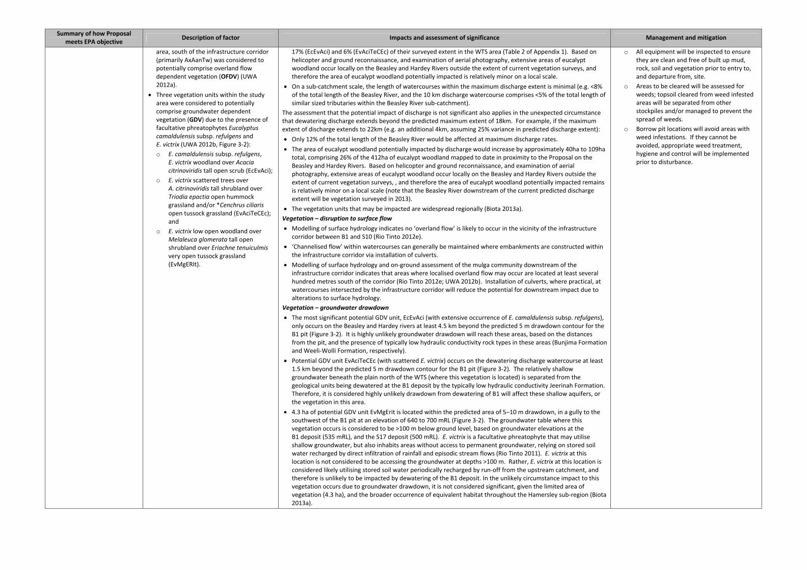
Summary of how Proposal meets EPA objective
Description of factor Impacts and assessment of significance Management and mitigation
area, south of the infrastructure corridor (primarily AxAanTw) was considered to potentially comprise overland flow dependent vegetation (OFDV) (UWA 2012a).
Three vegetation units within the study area were considered to potentially comprise groundwater dependent vegetation (GDV) due to the presence of facultative phreatophytes Eucalyptus camaldulensis subsp. refulgens and E. victrix (UWA 2012b, Figure 3‐2):
o E. camaldulensis subsp. refulgens, E. victrix woodland over Acacia citrinoviridis tall open scrub (EcEvAci);
o E. victrix scattered trees over A. citrinoviridis tall shrubland over Triodia epactia open hummock grassland and/or *Cenchrus ciliaris open tussock grassland (EvAciTeCEc); and
o E. victrix low open woodland over Melaleuca glomerata tall open shrubland over Eriachne tenuiculmis very open tussock grassland (EvMgERIt).
17% (EcEvAci) and 6% (EvAciTeCEc) of their surveyed extent in the WTS area (Table 2 of Appendix 1). Based on helicopter and ground reconnaissance, and examination of aerial photography, extensive areas of eucalypt woodland occur locally on the Beasley and Hardey Rivers outside the extent of current vegetation surveys, and therefore the area of eucalypt woodland potentially impacted is relatively minor on a local scale.
On a sub‐catchment scale, the length of watercourses within the maximum discharge extent is minimal (e.g. <8% of the total length of the Beasley River, and the 10 km discharge watercourse comprises <5% of the total length of similar sized tributaries within the Beasley River sub‐catchment).
The assessment that the potential impact of discharge is not significant also applies in the unexpected circumstance that dewatering discharge extends beyond the predicted maximum extent of 18km. For example, if the maximum extent of discharge extends to 22km (e.g. an additional 4km, assuming 25% variance in predicted discharge extent):
Only 12% of the total length of the Beasley River would be affected at maximum discharge rates.
The area of eucalypt woodland potentially impacted by discharge would increase by approximately 40ha to 109ha total, comprising 26% of the 412ha of eucalypt woodland mapped to date in proximity to the Proposal on the Beasley and Hardey Rivers. Based on helicopter and ground reconnaissance, and examination of aerial photography, extensive areas of eucalypt woodland occur locally on the Beasley and Hardey Rivers outside the extent of current vegetation surveys, , and therefore the area of eucalypt woodland potentially impacted remains is relatively minor on a local scale (note that the Beasley River downstream of the current predicted discharge extent will be vegetation surveyed in 2013).
The vegetation units that may be impacted are widespread regionally (Biota 2013a).
Vegetation – disruption to surface flow Modelling of surface hydrology indicates no ‘overland flow’ is likely to occur in the vicinity of the infrastructure
corridor between B1 and S10 (Rio Tinto 2012e).
‘Channelised flow’ within watercourses can generally be maintained where embankments are constructed within the infrastructure corridor via installation of culverts.
Modelling of surface hydrology and on‐ground assessment of the mulga community downstream of the infrastructure corridor indicates that areas where localised overland flow may occur are located at least several hundred metres south of the corridor (Rio Tinto 2012e; UWA 2012b). Installation of culverts, where practical, at watercourses intersected by the infrastructure corridor will reduce the potential for downstream impact due to alterations to surface hydrology.
Vegetation – groundwater drawdown The most significant potential GDV unit, EcEvAci (with extensive occurrence of E. camaldulensis subsp. refulgens),
only occurs on the Beasley and Hardey rivers at least 4.5 km beyond the predicted 5 m drawdown contour for the B1 pit (Figure 3‐2). It is highly unlikely groundwater drawdown will reach these areas, based on the distances from the pit, and the presence of typically low hydraulic conductivity rock types in these areas (Bunjima Formation and Weeli‐Wolli Formation, respectively).
Potential GDV unit EvAciTeCEc (with scattered E. victrix) occurs on the dewatering discharge watercourse at least 1.5 km beyond the predicted 5 m drawdown contour for the B1 pit (Figure 3‐2). The relatively shallow groundwater beneath the plain north of the WTS (where this vegetation is located) is separated from the geological units being dewatered at the B1 deposit by the typically low hydraulic conductivity Jeerinah Formation. Therefore, it is considered highly unlikely drawdown from dewatering of B1 will affect these shallow aquifers, or the vegetation in this area.
4.3 ha of potential GDV unit EvMgErit is located within the predicted area of 5–10 m drawdown, in a gully to the southwest of the B1 pit at an elevation of 640 to 700 mRL (Figure 3‐2). The groundwater table where this vegetation occurs is considered to be >100 m below ground level, based on groundwater elevations at the B1 deposit (535 mRL), and the S17 deposit (500 mRL). E. victrix is a facultative phreatophyte that may utilise shallow groundwater, but also inhabits areas without access to permanent groundwater, relying on stored soil water recharged by direct infiltration of rainfall and episodic stream flows (Rio Tinto 2011). E. victrix at this location is not considered to be accessing the groundwater at depths >100 m. Rather, E. victrix at this location is considered likely utilising stored soil water periodically recharged by run‐off from the upstream catchment, and therefore is unlikely to be impacted by dewatering of the B1 deposit. In the unlikely circumstance impact to this vegetation occurs due to groundwater drawdown, it is not considered significant, given the limited area of vegetation (4.3 ha), and the broader occurrence of equivalent habitat throughout the Hamersley sub‐region (Biota 2013a).
o All equipment will be inspected to ensure they are clean and free of built up mud, rock, soil and vegetation prior to entry to, and departure from, site.
o Areas to be cleared will be assessed for weeds; topsoil cleared from weed infested areas will be separated from other stockpiles and/or managed to prevent the spread of weeds.
o Borrow pit locations will avoid areas with weed infestations. If they cannot be avoided, appropriate weed treatment, hygiene and control will be implemented prior to disturbance.
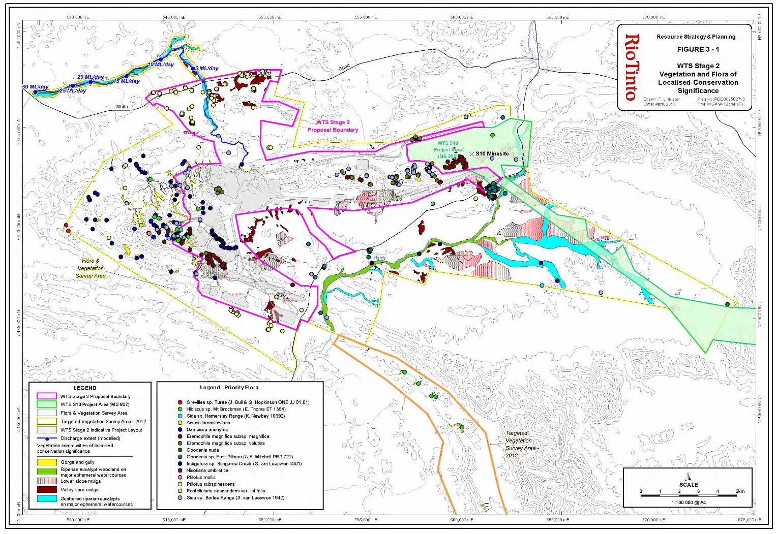

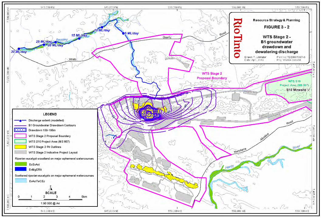

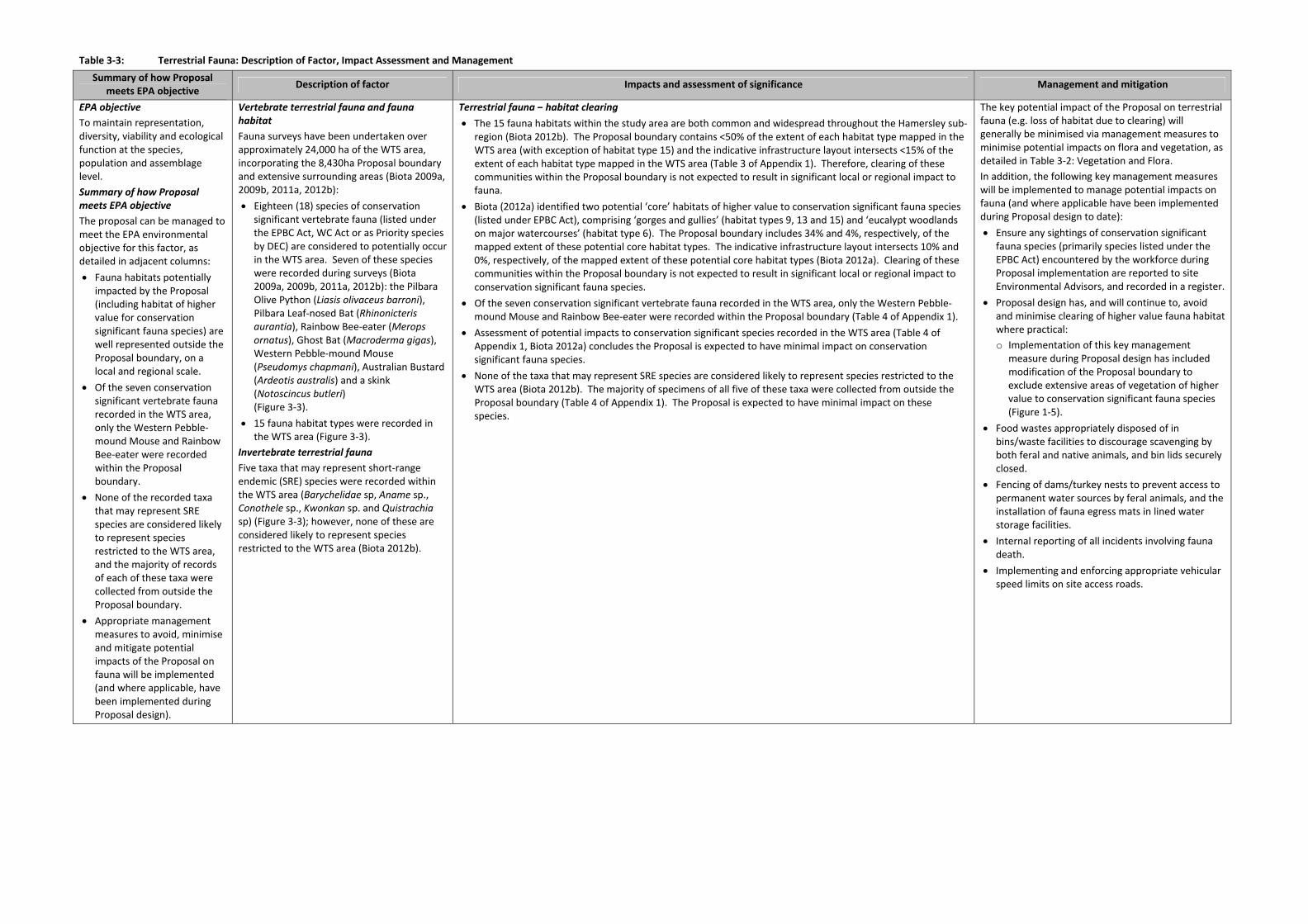
Table 3‐3: Terrestrial Fauna: Description of Factor, Impact Assessment and Management
Summary of how Proposal meets EPA objective
Description of factor Impacts and assessment of significance Management and mitigation
EPA objective To maintain representation, diversity, viability and ecological function at the species, population and assemblage level.
Summary of how Proposal meets EPA objective The proposal can be managed to meet the EPA environmental objective for this factor, as detailed in adjacent columns:
Fauna habitats potentially impacted by the Proposal (including habitat of higher value for conservation significant fauna species) are well represented outside the Proposal boundary, on a local and regional scale.
Of the seven conservation significant vertebrate fauna recorded in the WTS area, only the Western Pebble‐mound Mouse and Rainbow Bee‐eater were recorded within the Proposal boundary.
None of the recorded taxa that may represent SRE species are considered likely to represent species restricted to the WTS area, and the majority of records of each of these taxa were collected from outside the Proposal boundary.
Appropriate management measures to avoid, minimise and mitigate potential impacts of the Proposal on fauna will be implemented (and where applicable, have been implemented during Proposal design).
Vertebrate terrestrial fauna and fauna habitat Fauna surveys have been undertaken over approximately 24,000 ha of the WTS area, incorporating the 8,430ha Proposal boundary and extensive surrounding areas (Biota 2009a, 2009b, 2011a, 2012b):
Eighteen (18) species of conservation significant vertebrate fauna (listed under the EPBC Act, WC Act or as Priority species by DEC) are considered to potentially occur in the WTS area. Seven of these species were recorded during surveys (Biota 2009a, 2009b, 2011a, 2012b): the Pilbara Olive Python (Liasis olivaceus barroni), Pilbara Leaf‐nosed Bat (Rhinonicteris aurantia), Rainbow Bee‐eater (Merops ornatus), Ghost Bat (Macroderma gigas), Western Pebble‐mound Mouse (Pseudomys chapmani), Australian Bustard (Ardeotis australis) and a skink (Notoscincus butleri) (Figure 3‐3).
15 fauna habitat types were recorded in the WTS area (Figure 3‐3).
Invertebrate terrestrial fauna Five taxa that may represent short‐range endemic (SRE) species were recorded within the WTS area (Barychelidae sp, Aname sp., Conothele sp., Kwonkan sp. and Quistrachia sp) (Figure 3‐3); however, none of these are considered likely to represent species restricted to the WTS area (Biota 2012b).
Terrestrial fauna – habitat clearing The 15 fauna habitats within the study area are both common and widespread throughout the Hamersley sub‐
region (Biota 2012b). The Proposal boundary contains <50% of the extent of each habitat type mapped in the WTS area (with exception of habitat type 15) and the indicative infrastructure layout intersects <15% of the extent of each habitat type mapped in the WTS area (Table 3 of Appendix 1). Therefore, clearing of these communities within the Proposal boundary is not expected to result in significant local or regional impact to fauna.
Biota (2012a) identified two potential ‘core’ habitats of higher value to conservation significant fauna species (listed under EPBC Act), comprising ‘gorges and gullies’ (habitat types 9, 13 and 15) and ‘eucalypt woodlands on major watercourses’ (habitat type 6). The Proposal boundary includes 34% and 4%, respectively, of the mapped extent of these potential core habitat types. The indicative infrastructure layout intersects 10% and 0%, respectively, of the mapped extent of these potential core habitat types (Biota 2012a). Clearing of these communities within the Proposal boundary is not expected to result in significant local or regional impact to conservation significant fauna species.
Of the seven conservation significant vertebrate fauna recorded in the WTS area, only the Western Pebble‐mound Mouse and Rainbow Bee‐eater were recorded within the Proposal boundary (Table 4 of Appendix 1).
Assessment of potential impacts to conservation significant species recorded in the WTS area (Table 4 of Appendix 1, Biota 2012a) concludes the Proposal is expected to have minimal impact on conservation significant fauna species.
None of the taxa that may represent SRE species are considered likely to represent species restricted to the WTS area (Biota 2012b). The majority of specimens of all five of these taxa were collected from outside the Proposal boundary (Table 4 of Appendix 1). The Proposal is expected to have minimal impact on these species.
The key potential impact of the Proposal on terrestrial fauna (e.g. loss of habitat due to clearing) will generally be minimised via management measures to minimise potential impacts on flora and vegetation, as detailed in Table 3‐2: Vegetation and Flora.
In addition, the following key management measures will be implemented to manage potential impacts on fauna (and where applicable have been implemented during Proposal design to date):
Ensure any sightings of conservation significant fauna species (primarily species listed under the EPBC Act) encountered by the workforce during Proposal implementation are reported to site Environmental Advisors, and recorded in a register.
Proposal design has, and will continue to, avoid and minimise clearing of higher value fauna habitat where practical:
o Implementation of this key management measure during Proposal design has included modification of the Proposal boundary to exclude extensive areas of vegetation of higher value to conservation significant fauna species (Figure 1‐5).
Food wastes appropriately disposed of in bins/waste facilities to discourage scavenging by both feral and native animals, and bin lids securely closed.
Fencing of dams/turkey nests to prevent access to permanent water sources by feral animals, and the installation of fauna egress mats in lined water storage facilities.
Internal reporting of all incidents involving fauna death.
Implementing and enforcing appropriate vehicular speed limits on site access roads.

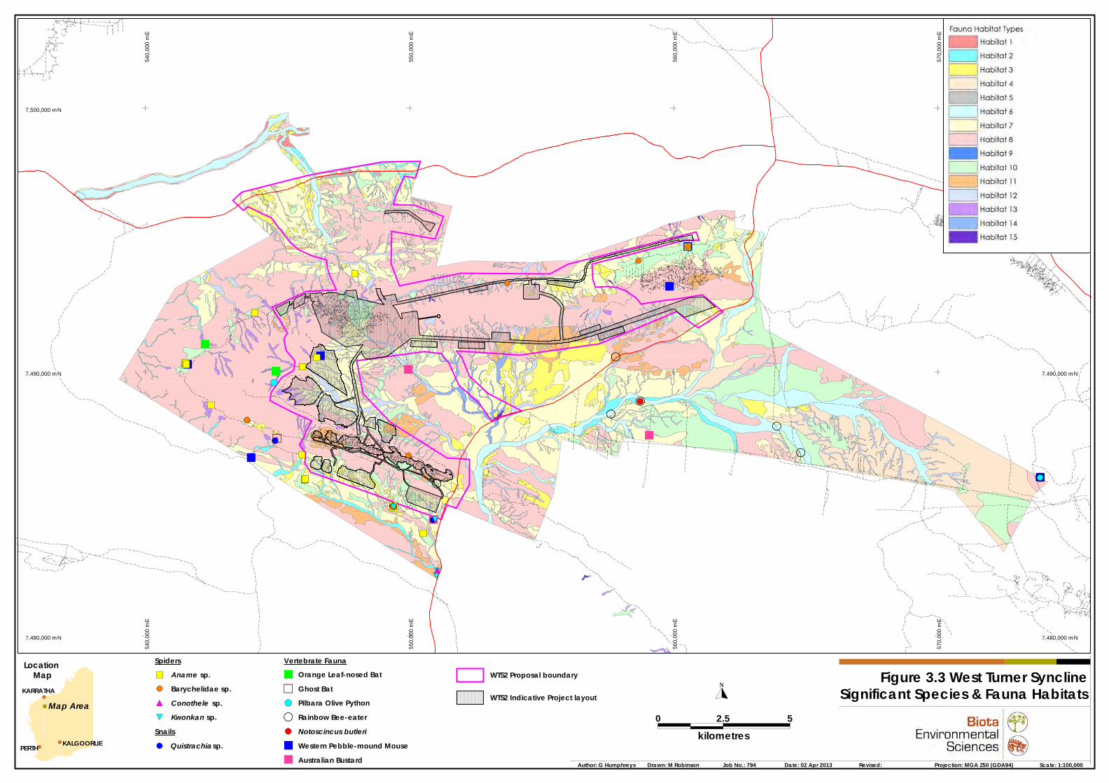
560,
000
mE
560,
000
mE
560,
000
mE
560,
000
mE
560,
000
mE
560,
000
mE
560,
000
mE
560,
000
mE
560,
000
mE
560,
000
mE
560,
000
mE
560,
000
mE
560,
000
mE
560,
000
mE
560,
000
mE
560,
000
mE
560,
000
mE
560,
000
mE
560,
000
mE
560,
000
mE
560,
000
mE
560,
000
mE
560,
000
mE
560,
000
mE
560,
000
mE
560,
000
mE
560,
000
mE
560,
000
mE
560,
000
mE
560,
000
mE
560,
000
mE
560,
000
mE
560,
000
mE
560,
000
mE
560,
000
mE
560,
000
mE
560,
000
mE
560,
000
mE
560,
000
mE
560,
000
mE
560,
000
mE
560,
000
mE
560,
000
mE
560,
000
mE
560,
000
mE
560,
000
mE
560,
000
mE
560,
000
mE
560,
000
mE
570,
000
mE
570,
000
mE
570,
000
mE
570,
000
mE
570,
000
mE
570,
000
mE
570,
000
mE
570,
000
mE
570,
000
mE
570,
000
mE
570,
000
mE
570,
000
mE
570,
000
mE
570,
000
mE
570,
000
mE
570,
000
mE
570,
000
mE
570,
000
mE
570,
000
mE
570,
000
mE
570,
000
mE
570,
000
mE
570,
000
mE
570,
000
mE
570,
000
mE
570,
000
mE
570,
000
mE
570,
000
mE
570,
000
mE
570,
000
mE
570,
000
mE
570,
000
mE
570,
000
mE
570,
000
mE
570,
000
mE
570,
000
mE
570,
000
mE
570,
000
mE
570,
000
mE
570,
000
mE
570,
000
mE
570,
000
mE
570,
000
mE
570,
000
mE
570,
000
mE
570,
000
mE
570,
000
mE
570,
000
mE
570,
000
mE
7,500,000 mN7,500,000 mN7,500,000 mN7,500,000 mN7,500,000 mN7,500,000 mN7,500,000 mN7,500,000 mN7,500,000 mN7,500,000 mN7,500,000 mN7,500,000 mN7,500,000 mN7,500,000 mN7,500,000 mN7,500,000 mN7,500,000 mN7,500,000 mN7,500,000 mN7,500,000 mN7,500,000 mN7,500,000 mN7,500,000 mN7,500,000 mN7,500,000 mN7,500,000 mN7,500,000 mN7,500,000 mN7,500,000 mN7,500,000 mN7,500,000 mN7,500,000 mN7,500,000 mN7,500,000 mN7,500,000 mN7,500,000 mN7,500,000 mN7,500,000 mN7,500,000 mN7,500,000 mN7,500,000 mN7,500,000 mN7,500,000 mN7,500,000 mN7,500,000 mN7,500,000 mN7,500,000 mN7,500,000 mN7,500,000 mN
7,490,000 mN7,490,000 mN7,490,000 mN7,490,000 mN7,490,000 mN7,490,000 mN7,490,000 mN7,490,000 mN7,490,000 mN7,490,000 mN7,490,000 mN7,490,000 mN7,490,000 mN7,490,000 mN7,490,000 mN7,490,000 mN7,490,000 mN7,490,000 mN7,490,000 mN7,490,000 mN7,490,000 mN7,490,000 mN7,490,000 mN7,490,000 mN7,490,000 mN7,490,000 mN7,490,000 mN7,490,000 mN7,490,000 mN7,490,000 mN7,490,000 mN7,490,000 mN7,490,000 mN7,490,000 mN7,490,000 mN7,490,000 mN7,490,000 mN7,490,000 mN7,490,000 mN7,490,000 mN7,490,000 mN7,490,000 mN7,490,000 mN7,490,000 mN7,490,000 mN7,490,000 mN7,490,000 mN7,490,000 mN7,490,000 mN
560,
000
mE
560,
000
mE
560,
000
mE
560,
000
mE
560,
000
mE
560,
000
mE
560,
000
mE
560,
000
mE
560,
000
mE
560,
000
mE
560,
000
mE
560,
000
mE
560,
000
mE
560,
000
mE
560,
000
mE
560,
000
mE
560,
000
mE
560,
000
mE
560,
000
mE
560,
000
mE
560,
000
mE
560,
000
mE
560,
000
mE
560,
000
mE
560,
000
mE
560,
000
mE
560,
000
mE
560,
000
mE
560,
000
mE
560,
000
mE
560,
000
mE
560,
000
mE
560,
000
mE
560,
000
mE
560,
000
mE
560,
000
mE
560,
000
mE
560,
000
mE
560,
000
mE
560,
000
mE
560,
000
mE
560,
000
mE
560,
000
mE
560,
000
mE
560,
000
mE
560,
000
mE
560,
000
mE
560,
000
mE
560,
000
mE
570,
000
mE
570,
000
mE
570,
000
mE
570,
000
mE
570,
000
mE
570,
000
mE
570,
000
mE
570,
000
mE
570,
000
mE
570,
000
mE
570,
000
mE
570,
000
mE
570,
000
mE
570,
000
mE
570,
000
mE
570,
000
mE
570,
000
mE
570,
000
mE
570,
000
mE
570,
000
mE
570,
000
mE
570,
000
mE
570,
000
mE
570,
000
mE
570,
000
mE
570,
000
mE
570,
000
mE
570,
000
mE
570,
000
mE
570,
000
mE
570,
000
mE
570,
000
mE
570,
000
mE
570,
000
mE
570,
000
mE
570,
000
mE
570,
000
mE
570,
000
mE
570,
000
mE
570,
000
mE
570,
000
mE
570,
000
mE
570,
000
mE
570,
000
mE
570,
000
mE
570,
000
mE
570,
000
mE
570,
000
mE
570,
000
mE
7,480,000 mN7,480,000 mN7,480,000 mN7,480,000 mN7,480,000 mN7,480,000 mN7,480,000 mN7,480,000 mN7,480,000 mN7,480,000 mN7,480,000 mN7,480,000 mN7,480,000 mN7,480,000 mN7,480,000 mN7,480,000 mN7,480,000 mN7,480,000 mN7,480,000 mN7,480,000 mN7,480,000 mN7,480,000 mN7,480,000 mN7,480,000 mN7,480,000 mN7,480,000 mN7,480,000 mN7,480,000 mN7,480,000 mN7,480,000 mN7,480,000 mN7,480,000 mN7,480,000 mN7,480,000 mN7,480,000 mN7,480,000 mN7,480,000 mN7,480,000 mN7,480,000 mN7,480,000 mN7,480,000 mN7,480,000 mN7,480,000 mN7,480,000 mN7,480,000 mN7,480,000 mN7,480,000 mN7,480,000 mN7,480,000 mN
540,
000
mE
540,
000
mE
540,
000
mE
540,
000
mE
540,
000
mE
540,
000
mE
540,
000
mE
540,
000
mE
540,
000
mE
540,
000
mE
540,
000
mE
540,
000
mE
540,
000
mE
540,
000
mE
540,
000
mE
540,
000
mE
540,
000
mE
540,
000
mE
540,
000
mE
540,
000
mE
540,
000
mE
540,
000
mE
540,
000
mE
540,
000
mE
540,
000
mE
540,
000
mE
540,
000
mE
540,
000
mE
540,
000
mE
540,
000
mE
540,
000
mE
540,
000
mE
540,
000
mE
540,
000
mE
540,
000
mE
540,
000
mE
540,
000
mE
540,
000
mE
540,
000
mE
540,
000
mE
540,
000
mE
540,
000
mE
540,
000
mE
540,
000
mE
540,
000
mE
540,
000
mE
540,
000
mE
540,
000
mE
540,
000
mE
550,
000
mE
550,
000
mE
550,
000
mE
550,
000
mE
550,
000
mE
550,
000
mE
550,
000
mE
550,
000
mE
550,
000
mE
550,
000
mE
550,
000
mE
550,
000
mE
550,
000
mE
550,
000
mE
550,
000
mE
550,
000
mE
550,
000
mE
550,
000
mE
550,
000
mE
550,
000
mE
550,
000
mE
550,
000
mE
550,
000
mE
550,
000
mE
550,
000
mE
550,
000
mE
550,
000
mE
550,
000
mE
550,
000
mE
550,
000
mE
550,
000
mE
550,
000
mE
550,
000
mE
550,
000
mE
550,
000
mE
550,
000
mE
550,
000
mE
550,
000
mE
550,
000
mE
550,
000
mE
550,
000
mE
550,
000
mE
550,
000
mE
550,
000
mE
550,
000
mE
550,
000
mE
550,
000
mE
550,
000
mE
550,
000
mE
7,500,000 mN7,500,000 mN7,500,000 mN7,500,000 mN7,500,000 mN7,500,000 mN7,500,000 mN7,500,000 mN7,500,000 mN7,500,000 mN7,500,000 mN7,500,000 mN7,500,000 mN7,500,000 mN7,500,000 mN7,500,000 mN7,500,000 mN7,500,000 mN7,500,000 mN7,500,000 mN7,500,000 mN7,500,000 mN7,500,000 mN7,500,000 mN7,500,000 mN7,500,000 mN7,500,000 mN7,500,000 mN7,500,000 mN7,500,000 mN7,500,000 mN7,500,000 mN7,500,000 mN7,500,000 mN7,500,000 mN7,500,000 mN7,500,000 mN7,500,000 mN7,500,000 mN7,500,000 mN7,500,000 mN7,500,000 mN7,500,000 mN7,500,000 mN7,500,000 mN7,500,000 mN7,500,000 mN7,500,000 mN7,500,000 mN
550,
000
mE
550,
000
mE
550,
000
mE
550,
000
mE
550,
000
mE
550,
000
mE
550,
000
mE
550,
000
mE
550,
000
mE
550,
000
mE
550,
000
mE
550,
000
mE
550,
000
mE
550,
000
mE
550,
000
mE
550,
000
mE
550,
000
mE
550,
000
mE
550,
000
mE
550,
000
mE
550,
000
mE
550,
000
mE
550,
000
mE
550,
000
mE
550,
000
mE
550,
000
mE
550,
000
mE
550,
000
mE
550,
000
mE
550,
000
mE
550,
000
mE
550,
000
mE
550,
000
mE
550,
000
mE
550,
000
mE
550,
000
mE
550,
000
mE
550,
000
mE
550,
000
mE
550,
000
mE
550,
000
mE
550,
000
mE
550,
000
mE
550,
000
mE
550,
000
mE
550,
000
mE
550,
000
mE
550,
000
mE
550,
000
mE
540,
000
mE
540,
000
mE
540,
000
mE
540,
000
mE
540,
000
mE
540,
000
mE
540,
000
mE
540,
000
mE
540,
000
mE
540,
000
mE
540,
000
mE
540,
000
mE
540,
000
mE
540,
000
mE
540,
000
mE
540,
000
mE
540,
000
mE
540,
000
mE
540,
000
mE
540,
000
mE
540,
000
mE
540,
000
mE
540,
000
mE
540,
000
mE
540,
000
mE
540,
000
mE
540,
000
mE
540,
000
mE
540,
000
mE
540,
000
mE
540,
000
mE
540,
000
mE
540,
000
mE
540,
000
mE
540,
000
mE
540,
000
mE
540,
000
mE
540,
000
mE
540,
000
mE
540,
000
mE
540,
000
mE
540,
000
mE
540,
000
mE
540,
000
mE
540,
000
mE
540,
000
mE
540,
000
mE
540,
000
mE
540,
000
mE
7,480,000 mN7,480,000 mN7,480,000 mN7,480,000 mN7,480,000 mN7,480,000 mN7,480,000 mN7,480,000 mN7,480,000 mN7,480,000 mN7,480,000 mN7,480,000 mN7,480,000 mN7,480,000 mN7,480,000 mN7,480,000 mN7,480,000 mN7,480,000 mN7,480,000 mN7,480,000 mN7,480,000 mN7,480,000 mN7,480,000 mN7,480,000 mN7,480,000 mN7,480,000 mN7,480,000 mN7,480,000 mN7,480,000 mN7,480,000 mN7,480,000 mN7,480,000 mN7,480,000 mN7,480,000 mN7,480,000 mN7,480,000 mN7,480,000 mN7,480,000 mN7,480,000 mN7,480,000 mN7,480,000 mN7,480,000 mN7,480,000 mN7,480,000 mN7,480,000 mN7,480,000 mN7,480,000 mN7,480,000 mN7,480,000 mN
7,490,000 mN7,490,000 mN7,490,000 mN7,490,000 mN7,490,000 mN7,490,000 mN7,490,000 mN7,490,000 mN7,490,000 mN7,490,000 mN7,490,000 mN7,490,000 mN7,490,000 mN7,490,000 mN7,490,000 mN7,490,000 mN7,490,000 mN7,490,000 mN7,490,000 mN7,490,000 mN7,490,000 mN7,490,000 mN7,490,000 mN7,490,000 mN7,490,000 mN7,490,000 mN7,490,000 mN7,490,000 mN7,490,000 mN7,490,000 mN7,490,000 mN7,490,000 mN7,490,000 mN7,490,000 mN7,490,000 mN7,490,000 mN7,490,000 mN7,490,000 mN7,490,000 mN7,490,000 mN7,490,000 mN7,490,000 mN7,490,000 mN7,490,000 mN7,490,000 mN7,490,000 mN7,490,000 mN7,490,000 mN7,490,000 mN
Author: G Humphreys Projection: MGA Z50 (GDA94)Revised: Job No.: 794Drawn: M Robinson Scale: 1:100,000Date: 02 Apr 2013
Figure 3.3 West Turner SynclineSignificant Species & Fauna Habitats
50 2.5
kilometres
Location Map
KALGOORLIEPERTH
Map Area
KARRATHA
Aname sp.
Conothele
Quistrachia
Barychelidae sp.
Snails
Kwonkan
Spiders
sp.
sp.
sp.
WTS2 Indicative Project layout
WTS2 Proposal boundary
Pilbara Olive Python
Notoscincus butleri
Australian Bustard
Orange Leaf-nosed Bat
Western Pebble-mound Mouse
Rainbow Bee-eater
Vertebrate Fauna
Ghost Bat

Table 3‐4: Subterranean Fauna: Description of Factor, Impact Assessment and Management
Summary of how Proposal meets EPA objective
Description of factor Impacts and assessment of significance Management and mitigation
EPA objective To maintain representation, diversity, viability and ecological function at the species, population and assemblage level. Summary of how Proposal meets EPA objective The proposal can be managed to meet the EPA environmental objective for this factor, as detailed in adjacent columns:
No significant populations or species of stygofauna were recorded during surveys in the Proposal boundary.
Troglofauna collected within the Proposal boundary comprised troglophiles (e.g. are not obligated to live in subterranean environments) rather than true troglobites; therefore, the Proposal poses a low risk of significant impact to these species.
Assessment of distribution of troglophiles, and likely continuity of habitat (based on geology) in the WTS area, indicate significant impact to troglofauna is unlikely.
Subterranean fauna are considered to occur in low density and limited diversity at WTS (Biota 2012c).
Stygofauna Sixteen (16) stygobitic specimens were collected; 15
specimens from the Order Amphipoda were collected at B1 and one specimen from the Order Cyclopoida (juvenile, species indeterminate) was collected at S17.
The amphipod species from B1 deposit is widespread throughout the Pilbara; the copepod from S17 is also likely to be widespread (Biota 2012c).
The stygofauna results indicate a low density stygal community, and suggest no significant groundwater fauna occurs in the locality (Biota 2012c).
Troglofauna The troglomorphic taxa collected at WTS comprise
troglophiles (e.g. are not obligated to live in subterranean environments) rather than true troglobites. Similar sampling efforts at other sites known to support troglobitic communities typically yield greater numbers of troglobitic animals (Biota 2012c).
Seventy seven (77) troglophiles were collected from five orders, with the most abundant groups comprising the Polyxenida and Blattodea.
Genetic analysis of the Polyxenida specimens indicated two lineages that occurred at both the B1 and S17 deposits – both have previously been sampled widely in the Pilbara.
Genetic analysis of the Blattodea specimens indicated two lineages. Lineage BNA comprised 24 individuals, collected at both the B1 and S17 deposits, and has previously been sampled widely in the Pilbara. Lineage BNR comprised one individual, collected at the S17 deposit, and has not been collected previously in the Pilbara, based on the limited material available for genetic comparison.
Other orders collected from the S17 deposit comprised Hemiptera (16 juveniles, species indeterminate), Pauropoda (one juvenile, species indeterminate), and Symphyla (one specimen, insufficient taxonomic research to determine species).
Stygofauna – groundwater drawdown and habitat removalNo significant populations or species of stygofauna have been recorded in the WTS area; therefore, the Proposal is considered unlikely to have a significant impact on stygofauna.
Troglofauna – habitat removal Both troglomorphic Polyxenida lineages and Blattodea Lineage BNA were detected at both the
B1 and S17 deposits, and from multiple sites elsewhere in the Pilbara; therefore, these species are not considered to be of conservation significance. The remaining three troglomorphic orders collected at S17 (Hemiptera, Pauropoda and Symphyla) are likely to have similar distributions to the Polyxenida and Blattodea, and therefore are not likely to be restricted to the WTS area (Biota 2012c).
The single specimen of troglomorphic Blattodea Lineage BNR is unlikely to be restricted to a single site in the WTS area and is likely to be more widespread, based on the following considerations (Biota 2012c):
o The single specimen of this species was recorded on the border of the Dales Gorge Member and Hydrated Zone at S17. Both of these geology units are considered continuous throughout the WTS area, and not restricted to the S17 deposit boundaries. Therefore, this species appears unlikely to be restricted in terms of geology.
o The presence of both Polyxenida lineages and Blattodea Lineage BNA at both the B1 and S17 deposits supports the previous observation that suitable habitat is unlikely to be restricted to deposit boundaries. Contiguous habitat extends at least along the ridge between the two deposits, and likely to be present more broadly in the WTS.
o The apparent spatial restriction of this single specimen is more likely due to the limited sequencing completed on Blattodea specimens from the Pilbara.
o Previous genetic studies on Blattodea in the Pilbara have found that short‐range endemism is not characteristic of this order.
Based on these site‐specific considerations, and the consideration that troglophiles are generally at minimal risk of conservation impacts due to local scale development proposals (Biota 2012c), the Proposal is considered unlikely to have a significant impact on troglofauna.
The following key management measure for subterranean fauna will be implemented:
Comparisons of the Blattodea Lineage BNR to Blattodea specimens collected from ongoing Rio Tinto Iron Ore (WA) projects in the Pilbara will be undertaken via molecular analysis.

Table 3‐5: Hydrological Processes and Inland Water Environmental Quality (Aquatic Fauna): Description of Factor, Impact Assessment and Management
Summary of how Proposal meets EPA objective
Description of factor Impacts and assessment of significance Management and Mitigation
EPA objective To maintain the quality of groundwater and surface water, sediment and/or biota so that the environmental values, both ecological and social, are protected.
Summary of how Proposal meets EPA objective The proposal can be managed to meet the EPA environmental objective for this factor, as detailed in adjacent columns:
All aquatic fauna species recorded in ephemeral pools within the dewater discharge extent have also been recorded outside the discharge extent, locally or regionally.
Groundwater from the B1 aquifer that will be discharged to the environment is generally of good quality.
Appropriate monitoring of discharge water quality will be undertaken.
Aquatic fauna Helicopter reconnaissance in the 2011 wet
and dry seasons established no ephemeral pools were present on the discharge watercourse between the discharge point and the junction with the Beasley River, 10 km downstream (WRM 2012a).
Ephemeral pools occur on the Beasley River both upstream and downstream of the junction with the discharge watercourse (e.g. the 8 km of the Beasley River within the maximum extent of discharge contains pools), and are populated by aquatic fauna assemblages (Figure 3‐4).
All aquatic fauna species recorded within the dewater discharge extent were also recorded at control sites (on the Beasley or Hardey River) or have been recorded elsewhere in the Pilbara (WRM 2012a) (Table 5 of Appendix 1).
Aquatic fauna – dewatering dischargeDewatering discharge will potentially impact aquatic fauna via changes in surface water quality and flow regimes:
Analysis of groundwater from the B1 aquifer indicates discharge water is generally of good quality, concentrations of all analytes are less than ANZECC/ARMCANZ (2000) water quality trigger values (TVs) for drinking water and livestock water; however, some analytes exceed TVs for the protection of aquatic ecosystems, particularly nutrients (WRM 2012b). For further detail on groundwater quality refer to Table 3‐6: Groundwater.
Discharge could reduce the diversity and abundance of aquatic fauna within the discharge extent, via: o The particular chemical characteristics of the groundwater being unfavourable for some species.
o Elevated nutrient concentrations could cause eutrophication that may have detrimental effects on some species.
o Precipitation of carbonate minerals could cause areas of cementation of river alluvium, thereby reducing habitat availability for some species.
o Change in aquatic fauna assemblages from species adapted to ephemeral pools to species adapted to more permanent water bodies.
The Proposal is considered unlikely to cause significant impacts to aquatic fauna on a local and regional scale, based on:
o The generally good quality of discharge water.
o The flushing and diluting effect of natural surface flows of high volume during the wet season.
o The relatively limited spatial and temporal extent of discharge (e.g. <8% of the total length of the Beasley River may be impacted, and the 10 km discharge watercourse comprises <5% of the total length of similar sized tributaries within the Beasley River sub‐catchment).
o The present distribution, both locally and regionally, of aquatic fauna species recorded in the dewater discharge area (e.g. no species is confined to the discharge area).
o The presence of similar habitat and fauna assemblages in the surrounding WTS area, including upstream of the discharge area, which provides recruitment sources to repopulate the area after cessation of discharge should fauna assemblages be altered.
The following key management measures for aquatic fauna will be implemented:
A Proposal discharge water quality management and monitoring strategy (including site‐specific water quality trigger values), will be developed in accordance with the ANZECC/ ARMCANZ (2000) water quality management framework, to manage the potential impacts of discharge water quality on the downstream environment.

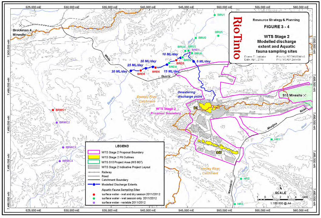

Table 3‐6: Hydrological Processes and Inland Water Environmental Quality (Groundwater): Description of Factor, Impact Assessment and Management
Summary of how Proposal meets EPA objective
Description of factor Impacts and assessment of significance Management and mitigation
EPA objective To maintain hydrological
regimes of groundwater and surface water so that existing and potential uses, including ecosystem maintenance, are protected.
To maintain the quality of groundwater and surface water, sediment and/or biota so that the environmental values, both ecological and social, are protected.
Summary of how Proposal meets EPA objective The proposal can be managed to meet the EPA environmental objective for this factor, as detailed in adjacent columns:
The B1 ore body aquifer is isolated from the regional groundwater system by low permeability geological units, and hence the total volume of water required to dewater the ore body, and the spatial extent of groundwater drawdown, are relatively limited.
The aquifer is predicted to recover to near pre‐mining water levels within approximately 60 years after cessation of dewatering.
No significant populations or species of stygofauna that may be affected by groundwater drawdown have been recorded in the vicinity of the B1 deposit.
Groundwater drawdown during dewatering of the B1 deposit is not expected to impact potentially groundwater dependent vegetation in the WTS area.
Hydrogeology The B1 orebody aquifer is considered to be
isolated from the regional groundwater system by low permeability un‐mineralised Brockman Iron Formation to the south, and Mount McRae Shale to the north (Figure 3‐5), Rio Tinto 2013a).
The B1 orebody aquifer is considered to be isolated from the aquifer in the Wittenoom formation located to the north of the deposit, by the low permeability Mount McRae Shale and Mt Silvia Formations.
The water table is approximately 40 mbgl in the central area of the B1 deposit, and approximately 62% of the B1 resource is BWT (Figure 3‐5).
The S17 orebody aquifer is considered to be isolated from the regional groundwater system by low permeability un‐mineralised Brockman Iron Formation and Mount McRae Shale Formation.
The water table at S17 is approximately 40 to 125 mbgl, and approximately 3% of the S17 resource is BWT (Figure 3‐6).
Groundwater quality Analysis of the B1 orebody aquifer indicates the groundwater is of good quality, concentrations of all analytes are less than ANZECC/ARMCANZ (2000) water quality trigger values (TVs) for drinking water and livestock water; however, several analytes exceed the default TVs for the protection of aquatic ecosystems (WRM 2012b):
Chromium and Copper are slightly above the 95% TVs, but are below 90% TVs.
Zinc (Zn) is above the 95% TV; however, data for Zn should be treated with caution, as the elevated levels are likely due to incidental contamination.
Mean and median values for nitrate are above the 95% TV, but are below the 80% TV.
Other nutrients are above default TVs (associated with eutrophication risk rather than direct toxicity) ‐ total phosphorus, filterable reactive phosphorus, nitrate‐nitrite nitrogen and total nitrogen (latter two analytes significantly above the default TVs).
Groundwater abstraction Dewatering of the B1 main pit via in‐pit bores is required at extraction rates of up to approximately
30 ML/day (11 GL/annum) to enable mining to a maximum depth of approximately 195 m BWT. Total dewatering volume is approximately 80 GL. Required rates of dewatering are expected to peak at 30 ML/day in 2015‐2017 and then decline to approximately 14 ML/day in 2018 to 2027 (Rio Tinto 2013a). The modelled groundwater drawdown is relatively limited in extent (Rio Tinto 2013a) (Figure 3‐2).
Abstraction of groundwater at B1 is expected to have minimal impact on other groundwater resources, as the available data indicate the orebody aquifer is isolated by low permeability un‐mineralised Brockman Iron Formation and Mount McRae Shale Formation (Rio Tinto 2013a).
At S17, minor dewatering is required for pits 3 and 8 (undertaken via in‐pit sumps) to a depth of approximately 15 m BWT. The other six pits at S17 are AWT. Extraction of groundwater from the S17 aquifer is expected to have minimal impact on surrounding local groundwater resources due to the minor volumes extracted, and the isolation of the orebody aquifer by low permeability un‐mineralised Brockman Iron Formation and Mount McRae Shale Formation.
Vegetation – groundwater drawdown
Refer to Table 3‐2: Vegetation and Flora.
Subterranean fauna –groundwater drawdown
Refer to Table 3‐4: Subterranean Fauna.
The following key management measures for groundwater will be implemented (and where applicable have been implemented during Proposal design to date):
Monitoring of water levels and abstraction rates during B1 dewatering, and ongoing validation of the hydrogeological conceptual model and numerical groundwater model.
Prioritisation of beneficial use of water extracted during dewatering, predominantly via utilisation to meet operational requirements (including planned supply to the nearby S10 minesite), with discharge to the environment the least preferred management option (Rio Tinto 2013b).
Management of pit voids that extend BWT at cessation of mining are considered in Table 3‐8: Rehabilitation and Closure.

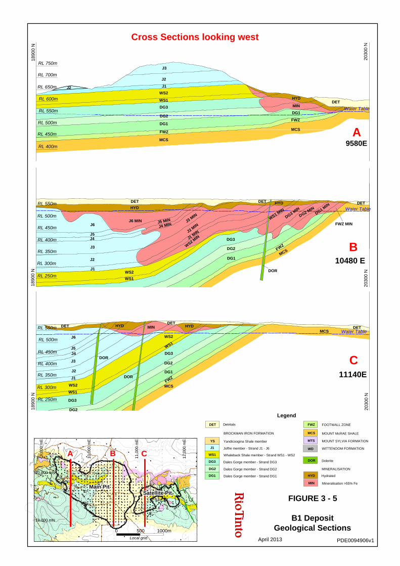
?
??
?
? ?
?
?
20,000 mN
19,000 mN
9,0
00
mE
10
,00
0 m
E
11
,00
0 m
E
12
,00
0 m
E
CB
Main PitMain PitMain PitMain PitMain PitMain PitMain PitMain PitMain PitMain PitMain PitMain PitMain PitMain PitMain PitMain PitMain PitMain PitMain PitMain PitMain PitMain PitMain PitMain PitMain PitMain PitMain PitMain PitMain PitMain PitMain PitMain PitMain PitMain PitMain PitMain PitMain PitMain PitMain PitMain PitMain PitMain PitMain PitMain PitMain PitMain PitMain PitMain PitMain PitSatellite PitSatellite PitSatellite PitSatellite PitSatellite PitSatellite PitSatellite PitSatellite PitSatellite PitSatellite PitSatellite PitSatellite PitSatellite PitSatellite PitSatellite PitSatellite PitSatellite PitSatellite PitSatellite PitSatellite PitSatellite PitSatellite PitSatellite PitSatellite PitSatellite PitSatellite PitSatellite PitSatellite PitSatellite PitSatellite PitSatellite PitSatellite PitSatellite PitSatellite PitSatellite PitSatellite PitSatellite PitSatellite PitSatellite PitSatellite PitSatellite PitSatellite PitSatellite PitSatellite PitSatellite PitSatellite PitSatellite PitSatellite PitSatellite Pit
A
FIGURE 3 - 5
B1 DepositGeological Sections
PDE0094906v1April 2013
11140E20
300
N
Water TableRL 550m
RL 250m
RL 500m
RL 450m
RL 400m
RL 300m
RL 350m
1890
0 N
DETMCS
HYDDET
DG1
FWZ
DG2
MCS
WS2
WS1
DG3
MINHYD
DOR
J2
DORJ3
J5J4
J6
WS2
WS1
DG3
DG2
J1
DET
10480 E
2030
0 N
Water Table
RL 300m
RL 400m
RL 350m
1890
0 N
RL 500m
RL 450m
RL 250m
RL 550m DET
FWZ MIN
DG1 MIN
DG2 MIN
DG3 MIN
FWZ
HYD
WS1 MIN
MCS
DOR
DET
DG1
DG2
DG3
J2 MIN
J1 MIN
WS2 M
IN
J3 MIN
J4 MINJ5 MINJ6 MIN
DET
HYD
WS1
WS2J1
J2
J5J4
J3
J6
2030
0 N
9580E
Water Table
RL 600m
RL 400m
RL 550m
RL 750m
RL 450m
RL 650m
RL 700m
1890
0 N
RL 500m
DETMIN
HYD
MCS
DG1
FWZ
MCS
DG1
DG2
FWZ
DG3
J1
J2
J3
WS2
WS1
J2
A
B
C
Cross Sections looking west
MOUNT McRAE SHALE
MOUNT SYLVIA FORMATION
WITTENOOM FORMATION
MINERALISATION
Mineralisation >55% Fe
FOOTWALL ZONEFWZ
HydratedHYD
MIN
DoleriteDOR
MCS
MTS
WD
Legend
Whaleback Shale member - Strand WS1 - WS2
Joffre member - Strand J1 - J6
Dales Gorge member - Strand DG3
Dales Gorge member - Strand DG2
Dales Gorge member - Strand DG1
Yandicoogina Shale member
BROCKMAN IRON FORMATION
Detritals
J1
WS1
DG2
DG1
DET
YS
DG3
500 1000m0
Local grid
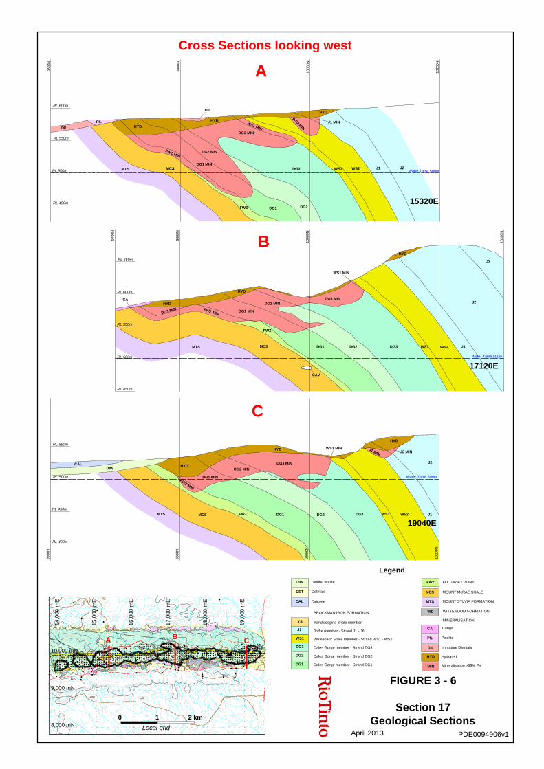
16
,00
0 m
E
17
,00
0 m
E
18
,00
0 m
E
19
,00
0 m
E
10,000 mN
9,000 mN
8,000 mN
15
,00
0 m
E
14
,00
0 m
E
C
66666666666666666666666666666666666666666666666667777777777777777777777777777777777777777777777777 88888888888888888888888888888888888888888888888884444444444444444444444444444444444444444444444444
5555555555555555555555555555555555555555555555555
B
3333333333333333333333333333333333333333333333333
A
11111111111111111111111111111111111111111111111112222222222222222222222222222222222222222222222222
FIGURE 3 - 6
Section 17Geological Sections
PDE0094906v1April 2013
J1 MIN
HYD
J2
J2 MIN
J1DG3 WS2WS1
WS1 MIN
DG3 MIN
DG1 DG2
DG1 MIN
DG2 MINHYD
HYD
FWZ MIN
MTS FWZMCS
CALDIW
9800
N
9600
N
RL 500m
RL 400m
RL 550m
RL 450m
1000
0N
1020
0N
19040E
Water Table 500m
J2
J3
WS1DG3DG2 WS2 J1
HYD
DG3 MIN
WS1 MIN
DG1
CAV
FWZ
MCS
HYD
DG2 MIN
DG1 MIN
MTS
HYD
DG1 MIN FWZ MIN
CA
RL 450m
9800
N
9700
N
RL 650m
RL 550m
RL 500m
RL 600m
1030
0N
1000
0N
17120EWater Table 500m
J1 MINW
S2 MIN
HYD
WS2WS1DG3 J1 J2
FWZ DG2DG1
WS1 MINDG3 MIN
DIL
HYD
DG1 MIN
FWZ MIN
MCS
DG2 MIN
MTS
PILHYDDIL
RL 500m
RL 450m
RL 600m
9600
N
9800
N
1020
0N
RL 550m
Water Table 500m
1000
0N
15320E
A
B
C
Cross Sections looking west
WITTENOOM FORMATION
MOUNT McRAE SHALE
MOUNT SYLVIA FORMATIONMTS
Mineralisation >55% Fe
Hydrated
Immature Detritals
MCS
FOOTWALL ZONEFWZ
CA
MINERALISATION
Canga
WD
HYD
MIN
DIL
Legend
Whaleback Shale member - Strand WS1 - WS2 PisolitePIL
Dales Gorge member - Strand DG1
Yandicoogina Shale member
BROCKMAN IRON FORMATION
Joffre member - Strand J1 - J6
Dales Gorge member - Strand DG3
Dales Gorge member - Strand DG2
CalcreteCAL
Detritals
Detrital Waste
DET
DIW
YS
J1
WS1
DG2
DG3
DG1
0 1 2 km
Local grid
Table 3‐7: Hydrological Processes and Inland Waters Environmental Quality (Surface Water): Description of Factor, Impact Assessment and Management
Summary of how Proposal meets EPA objective
Description of factor Impacts and assessment of significance Management and mitigation
EPA objectives To maintain hydrological regimes
of groundwater and surface water so that existing and potential uses, including ecosystem maintenance, are protected.
To maintain the quality of groundwater and surface water, sediment and/or biota so that the environmental values, both ecological and social, are protected.
Summary of how Proposal meets EPA objective The proposal can be managed to meet the EPA environmental objectives for this factor, as detailed in adjacent columns:
Groundwater from the B1 orebody aquifer that will be discharged to the environment is generally of good quality.
The spatial and temporal extent of dewatering discharge is relatively limited, and substantial areas of similar watercourses occur outside the discharge extent within the Beasley River sub‐catchment.
Appropriate monitoring and management of discharge water quality will be undertaken, in accordance with the ANZECC/ARMCANZ (2000) water quality management framework.
The infrastructure corridor is unlikely to impact overland flow or potentially dependent vegetation, and channelised flow will be maintained where practical via culvert installation.
Appropriate management measures to avoid, and minimise potential impacts of the Proposal on surface water will be implemented (and where applicable have been implemented during Proposal design).
Dewatering discharge Dewatering in excess of operational requirements will be discharged to a minor watercourse north of the
B1 deposit, that joins the Beasley River approximately 10 km downstream of the discharge point (Figure 3‐2).
During the first three years of operation, potential discharge of up to 30 ML/day (excluding on‐site water use of 6 ML/day) is predicted to extend approximately 18 km downstream of the discharge point (Rio Tinto 2012a).
From 2018 to 2027, potential discharge of approximately 14 ML/day (excluding on‐site water use of 6 ML/day) is predicted to extend approximately 13 km downstream of the discharge point (Rio Tinto 2012a).
With on‐site water use of approximately 6 ML/day, discharge is expected to be <10 ML/day for the majority of the life of the Proposal.
Beasley River The Beasley River is approximately 100km in length, and is a tributary of the Hardey River (that eventually joins
the Ashburton River a further 90km downstream). Dewatering discharge will occur in the upper reaches of the Beasley River, approximately 70km upstream of the junction with the Hardey River.
Approximately 8% of the total length of the Beasley River is within the predicted maximum discharge extent (additionally, the 10 km discharge watercourse comprises <5% of the total length of similar sized tributaries within the Beasley River sub‐catchment).
The Beasley River sub‐catchment comprises 2.6% of the total area of the Ashburton River catchment. Multiple named rivers and creeks in the southern half of the Hamersley sub‐region are tributaries of the Ashburton River (including the Hardey River, Angelo River, Turee Creek, Seven Mile Creek, Duck Creek, Urandy Creek).
A eucalypt woodland of of E. camaldulensis subsp. refulgens and E. victrix (EcEvAci) occurs immediately adjacent to the Beasley River, bordered by scattered E. victrix (EvAciTeCEc). Extensive areas of these communities have also been mapped in the WTS area on the Hardey River. The Hardey River and associated eucalypt woodland in the WTS area is more substantial (e.g. vegetation unit EcEvAci generally mapped as 150‐400m in width) compared to the Beasley River (vegetation unit EcEvAci generally mapeed as 50‐200 m in width) (Figure 7). Based on helicopter and ground reconnaissance, and examination of aerial photography, extensive areas of eucalypt woodland occur locally on the Beasley and Hardey Rivers outside the extent of current vegetation surveys, and therefore the area of eucalypt woodland on the Beasley River potentially impacted by discharge is relatively minor on a local scale.
The vegetation communities EcEvAci and EvAciTeCEc on major ephemeral watercourses are considered to have local significance as a vegetation community and as fauna habitat, but are not considered regionally significant as they are widespread in the Pilbara (Biota 2012a; Biota 2012b; Biota 2013a).
Watercourses throughout the WTS area, including the Beasley River, are impacted cattle from the Rocklea pastoral station. The surveyed extent of the Beasley River is colonised by multiple weeds (15 weed species recorded, more significant environmental weed species present include Buffel Grass, Kapok, Birdwood Grass, Mimosa Bush, Spiked Malvastrum). The condition of vegetation on the Beasley River, and on the 10km discharge watercourse, was described as good to very poor, due to weeds and cattle impacts (Biota 2013a). The Hardey River has a similar suite of weeds present, and vegetation was also described as good to very poor due to weeds and cattle impacts (Biota 2013a).
Although conservation significant fauna species are likely to utilise the eucalypt woodland within the surveyed extent of the Beasley River, no significant species were recorded on the Beasley River during fauna surveys (Biota 2012a; Figure 9).
Ephemeral pools occur on the Beasley River both upstream and downstream of the junction with the discharge watercourse and are populated by aquatic fauna assemblages (Figure 3‐4). All aquatic fauna species recorded within the dewater discharge extent on the Beasley River were also recorded at control sites (on the Beasley or Hardey River) or have been recorded elsewhere in the Pilbara (WRM 2012a)
Surface water flows Modelling of surface hydrology in the vicinity of the infrastructure corridor indicates the following outcomes (Rio Tinto 2012e):
no ‘overland flow’ is likely to occur in the vicinity of the proposed infrastructure corridor; ‘channelised flow’ within watercourses can generally be maintained where embankments are constructed
within the infrastructure corridor via installation of culverts.
Vegetation – dewatering discharge
Detrimental impacts to vegetation bordering the watercourses affected by dewatering discharge may occur, but is not considered significant, primarily due to the widespread occurrence of the relevant vegetation communities in the local area, and the relatively limited temporal and spatial extent of discharge. Refer to detailed assessment in Table 3‐2: Vegetation and Flora.
Vegetation – disruption to surface flow
No significant impact expected ‐ refer to detailed assessment in Table 3‐2: Vegetation and Flora.
Aquatic fauna – dewatering discharge
Some detrimental impacts to aquatic fauna within the extent of dewatering discharge may occur, but is not considered significant, as all aquatic fauna species within the discharge extent have been recorded elsewhere in the Pilbara, and due to the relatively limited temporal and spatial extent of discharge. Refer to detailed assessment in Table 3‐5: Aquatic Fauna.
The following key management measures for surface water will be implemented (and where applicable have been implemented during Proposal design to date):
The Proposal surface water management plan has, and will continue to, be implemented (Rio Tinto 2012c) with the objective of minimising adverse impacts to water courses, water quality and the downstream environment.
Proposal design has, and will continue to, incorporate consideration of surface water management, including minimising disruption to watercourses where practical (Rio Tinto 2012c, 2012e).
Prioritisation of beneficial use of water extracted during dewatering, predominantly via utilisation to meet operational requirements (including planned supply to the nearby S10 mine site), with discharge to the environment the least preferred management option (Rio Tinto 2012b).
A Proposal discharge water quality management and monitoring strategy (including site‐specific water quality trigger values), will be developed in accordance with the ANZECC/ARMCANZ (2000) water quality management framework, to manage the potential impacts of discharge water quality on the downstream environment.

Table 3‐8: Rehabilitation and Closure: Description of Factor, Impact Assessment and Management
Summary of how Proposal meets EPA objective
Description of factor Impacts and assessment of significance Management and mitigation
EPA objectives To ensure that premises can be closed, decommissioned and rehabilitated in an ecologically sustainable manner, consistent with agreed outcomes and land uses, and without unacceptable liability to the State.
Summary of how Proposal meets EPA objective The proposal can be managed to meet the EPA environmental objectives for this factor, as detailed in adjacent columns:
Mineral waste dumps are unlikely to have significant environmental impacts, based on analysis of mineral waste volumes, and physical and chemical properties, which indicates the majority of mineral waste is relatively benign.
Pit voids are unlikely to have significant environmental impacts, based on predicted water quality of the proposed B1 pit lake, and commitment to backfill S17 pits to a level sufficient to prevent formation of pit lakes.
A Mine Closure Plan has been developed in accordance with the DMP/EPA (2011) Mine Closure Guideline, which provides appropriate management measures regarding closure and rehabilitation, and will be regularly reviewed and updated during the operational phase of the Proposal.
Geology The B1 and S17 deposits occur within the Brockman Iron Formation of the Hamersley Group, and are typical of similar Banded Iron Formation derived deposits that occur throughout the Pilbara. The Brockman Iron Formation comprises four members (Yandicoogina Shale, Joffre, Whaleback Shale, and Dales Gorge), and is underlain by the Mount McRae Shale. Mineralisation at B1 and S17 occurs primarily within the Dales Gorge and Joffre Members, and to a lesser extent within the Whaleback Shale Member (Figure 3‐5 and Figure 3‐6). Both B1 and S17 are predominantly bedded deposits, although some deposits of secondary surficial ironstone have also accumulated. Rio Tinto has extensive experience mining similar deposits within the Brockman Iron Formation at other mines in the Pilbara.
Mineral waste physical characteristics Substantial volumes of mineral waste classified as ‘low’ to ‘medium’ erodibility will be mined from both the B1 and S17 deposits (Rio Tinto 2012g).
Mineral waste geochemical characteristics The AMD risk assessment for the B1 deposit identified a moderate AMD risk, and for the
S17 deposit a low‐moderate AMD risk. This assessment was based primarily on the presence of unoxidised Mt McRae Shale in proximity to the deposits (Rio Tinto 2012f).
Additionally, some elevated Sulfur levels were recorded AWT in other rock types, that may contain alunite, which can release low levels of acid.
Mineral waste that may pose an AMD risk comprises <3% of the B1 waste, and <2% of the S17 waste (Rio Tinto 2012f).
Pit voids and lakes The B1 main pit will be mined to a maximum depth of approximately 195 m BWT. The
four B1 satellite pits are AWT and will be progressively backfilled where practical. Progressive backfill of the B1 main pit during operations is not practical due to the required pit design and operational constraints.
A pit lake will form in the B1 main pit void, with water level recovery to approximately 525 mRL after 60 years (Rio Tinto 2013a), resulting in a maximum pit lake depth of approximately 185 m, and a pit lake surface approximately 50 mbgl. The B1 pit void will comprise a groundwater sink (Rio Tinto 2013a).
The B1 pit lake is expected to salinise after approximately 450 years, with pH declining from 8.3 to 5.5 over 1000 years (KCB 2012b).
The final equilibrated water quality of the pit lake (at 1000 years) indicates B, F, SO4, and Se are above the ANZECC/ARMCANZ (2000) livestock water quality trigger values, while As, F, Mn, Pb, SO4 and Se are above the ANZECC/ARMCANZ (2000) drinking water trigger values (KCB 2012b).
Groundwater recovery has been remodelled since the KCB (2012) water quality modelling; however, the predicted higher steady state water level (e.g. 525 mRL vs. 490 mRL) and increased rate of recovery to a steady state water level (e.g. 60 vs. 150 years) is not expected to significantly change the KCB (2012b) water quality predictions (Rio Tinto 2012d). The water quality model will be re‐run to confirm this assessment.
At S17, pits 3 and 8 will be mined to approximately 15 m BWT; these pits will be preferentially backfilled to a level sufficient to prevent formation of pit lakes. The remaining pits at S17 are AWT, and backfill will be undertaken where practical; however, pit voids are expected to remain at closure.
Waste dumpsWaste dumps are considered unlikely to have significant environmental impacts based on the following considerations:
waste dump designs have considered the physical and chemical properties of waste material;
substantial volumes of competent waste is available, enabling design/construction of waste dumps that are stable and not susceptible to excessive erosion; and
substantial volumes of inert waste material is available, enabling design/construction of waste dumps that encapsulate the low volumes of waste rock that poses a potential AMD risk.
Pit voids Pit voids are considered unlikely to have significant environmental impacts based on the following considerations:
S17 pits 3 and 8 (that extend approximately 15 m BWT) will be preferentially backfilled to a level sufficient to prevent formation of pit lakes.
The B1 pit lake will comprise a groundwater sink, minimising potential for impacts beyond the immediate vicinity of the pit lake.
The B1 pit lake is predicted to maintain circumneutral pH over 1000 years, and while concentration of a limited suite of elements may reach ANZECC/ARMCANZ (2000) trigger levels, a preliminary assessment suggests the pit lake is likely to pose a low ecological risk (Equinox Environmental 2012).
Rio Tinto is committed to ensuring the B1 pit lake will meet closure objectives, in particular that “Pit voids do not cause significant adverse impacts on the regional groundwater resource, or environmental values of the WTS area”. During the operational phase, Rio Tinto will undertake periodic review of the preferred closure strategy for the B1 pit lake (no backfill, potentially with implementation of additional management measures) based on ongoing improvements in geological, hydrogeological, geotechnical and environmental knowledge.
While a non‐preferred closure strategy, backfill of the B1 pit void is a management option that will be considered should ongoing investigations, and/or monitoring, establish the predicted or actual impacts of a pit lake managed via the preferred closure strategy will not meet closure objectives.
Closure will be undertaken in accordance with the Mine Closure Plan (Rio Tinto 2012g; Appendix 23), which details management and mitigation measures, including the following:
The Rio Tinto Iron Ore (WA) Landform Design Guidelines will continue to be implemented to ensure waste dumps meet closure objectives.
The Rio Tinto Iron Ore (WA) Mineral Waste Management Plan, and the Spontaneous Combustion and ARD (SCARD) Management Plan will continue to be implemented, to ensure waste material is adequately geochemically characterised (via static testing, and kinetic testing where warranted) during Proposal planning and operational stages, and material that poses an AMD risk is appropriately managed. Ongoing tests and studies include:
o Static and Kinetic testing of samples from B1 and Section 17;
o Leaching under highly saline conditions;
o Leaching under lower contact ratios.
The Rio Tinto Iron Ore (WA) Soil Resource Management Work Practice will be implemented to manage recovery and storage of topsoil and subsoil resources.
S17 Pits 3 and 8 will be preferentially backfilled to a level sufficient to prevent formation of pit lakes.
Rio Tinto will undertake periodic review of the preferred closure strategy for the B1 pit lake (no backfill, potentially with implementation of additional management measures) based on ongoing improvements in geological, hydrogeological, geotechnical and environmental knowledge, to ensure the pit lake closure strategy will achieve closure objectives.

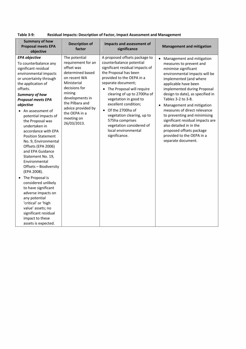
Table 3‐9: Residual Impacts: Description of Factor, Impact Assessment and Management
Summary of how Proposal meets EPA
objective
Description of factor
Impacts and assessment of significance
Management and mitigation
EPA objective To counterbalance any significant residual environmental impacts or uncertainty through the application of offsets.
Summary of how Proposal meets EPA objective An assessment of
potential impacts of the Proposal was undertaken in accordance with EPA Position Statement No. 9, Environmental Offsets (EPA 2006) and EPA Guidance Statement No. 19, Environmental Offsets – Biodiversity (EPA 2008).
The Proposal is considered unlikely to have significant adverse impacts on any potential ‘critical’ or ‘high value’ assets; no significant residual impact to these assets is expected.
The potential requirement for an offset was determined based on recent WA Ministerial decisions for mining developments in the Pilbara and advice provided by the OEPA in a meeting on 26/03/2013.
A proposed offsets package to counterbalance potential significant residual impacts of the Proposal has been provided to the OEPA in a separate document;
The Proposal will require clearing of up to 2700ha of vegetation in good to excellent condition;
Of the 2700ha of vegetation clearing, up to 575ha comprises vegetation considered of local environmental significance.
Management and mitigation measures to prevent and minimise significant environmental impacts will be implemented (and where applicable have been implemented during Proposal design to date), as specified in Tables 3‐2 to 3‐8.
Management and mitigation measures of direct relevance to preventing and minimising significant residual impacts are also detailed in in the proposed offsets package provided to the OEPA in a separate document.


Western Turner Syncline Stage 2 – B1 and S17 Deposits API: Environmental Review Document
Page 61
4 OTHER ENVIRONMENTAL FACTORS
Table 4‐1 briefly outlines potential impacts and management associated with other environmental factors
for the Proposal, that were not identified as key factors in the EPA‐prepared Environmental Scoping
Document.
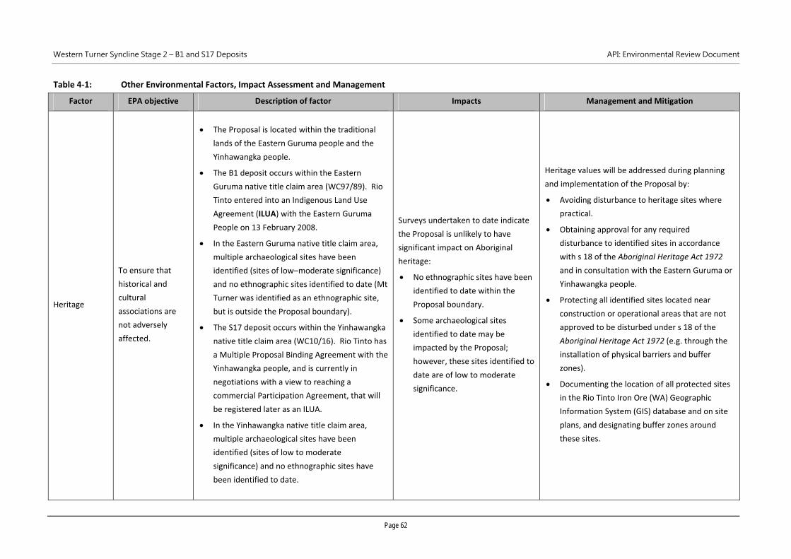
Western Turner Syncline Stage 2 – B1 and S17 Deposits API: Environmental Review Document
Page 62
Table 4‐1: Other Environmental Factors, Impact Assessment and Management
Factor EPA objective Description of factor Impacts Management and Mitigation
Heritage
To ensure that
historical and
cultural
associations are
not adversely
affected.
The Proposal is located within the traditional
lands of the Eastern Guruma people and the
Yinhawangka people.
The B1 deposit occurs within the Eastern
Guruma native title claim area (WC97/89). Rio
Tinto entered into an Indigenous Land Use
Agreement (ILUA) with the Eastern Guruma
People on 13 February 2008.
In the Eastern Guruma native title claim area,
multiple archaeological sites have been
identified (sites of low–moderate significance)
and no ethnographic sites identified to date (Mt
Turner was identified as an ethnographic site,
but is outside the Proposal boundary).
The S17 deposit occurs within the Yinhawangka
native title claim area (WC10/16). Rio Tinto has
a Multiple Proposal Binding Agreement with the
Yinhawangka people, and is currently in
negotiations with a view to reaching a
commercial Participation Agreement, that will
be registered later as an ILUA.
In the Yinhawangka native title claim area,
multiple archaeological sites have been
identified (sites of low to moderate
significance) and no ethnographic sites have
been identified to date.
Surveys undertaken to date indicate
the Proposal is unlikely to have
significant impact on Aboriginal
heritage:
No ethnographic sites have been
identified to date within the
Proposal boundary.
Some archaeological sites
identified to date may be
impacted by the Proposal;
however, these sites identified to
date are of low to moderate
significance.
Heritage values will be addressed during planning
and implementation of the Proposal by:
Avoiding disturbance to heritage sites where
practical.
Obtaining approval for any required
disturbance to identified sites in accordance
with s 18 of the Aboriginal Heritage Act 1972
and in consultation with the Eastern Guruma or
Yinhawangka people.
Protecting all identified sites located near
construction or operational areas that are not
approved to be disturbed under s 18 of the
Aboriginal Heritage Act 1972 (e.g. through the
installation of physical barriers and buffer
zones).
Documenting the location of all protected sites
in the Rio Tinto Iron Ore (WA) Geographic
Information System (GIS) database and on site
plans, and designating buffer zones around
these sites.
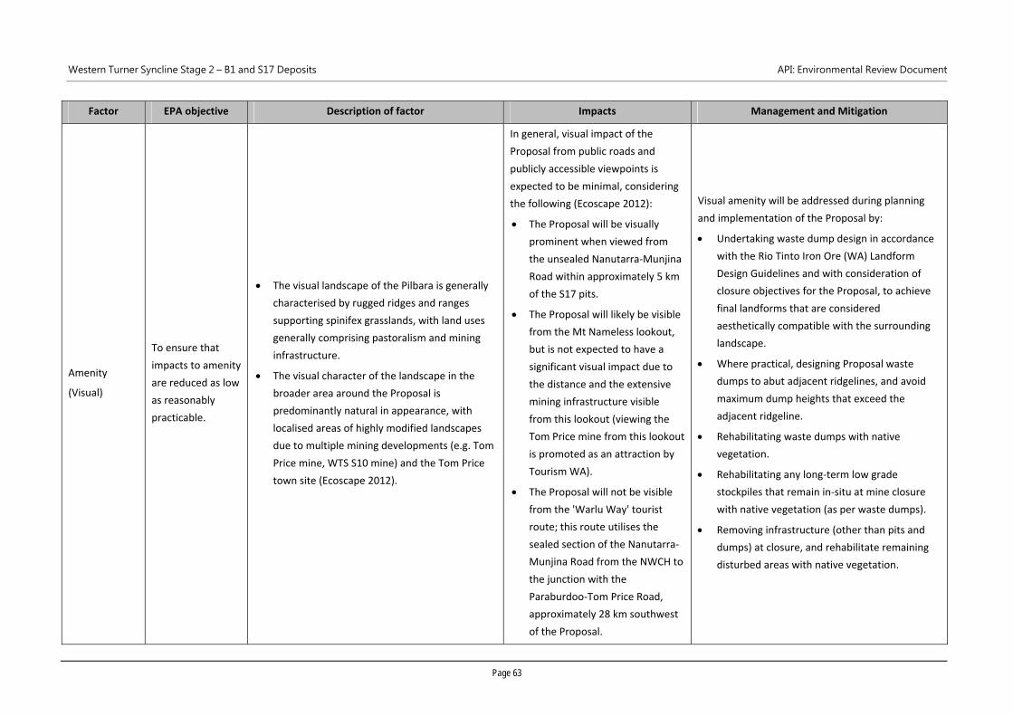
Western Turner Syncline Stage 2 – B1 and S17 Deposits API: Environmental Review Document
Page 63
Factor EPA objective Description of factor Impacts Management and Mitigation
Amenity
(Visual)
To ensure that
impacts to amenity
are reduced as low
as reasonably
practicable.
The visual landscape of the Pilbara is generally
characterised by rugged ridges and ranges
supporting spinifex grasslands, with land uses
generally comprising pastoralism and mining
infrastructure.
The visual character of the landscape in the
broader area around the Proposal is
predominantly natural in appearance, with
localised areas of highly modified landscapes
due to multiple mining developments (e.g. Tom
Price mine, WTS S10 mine) and the Tom Price
town site (Ecoscape 2012).
In general, visual impact of the
Proposal from public roads and
publicly accessible viewpoints is
expected to be minimal, considering
the following (Ecoscape 2012):
The Proposal will be visually
prominent when viewed from
the unsealed Nanutarra‐Munjina
Road within approximately 5 km
of the S17 pits.
The Proposal will likely be visible
from the Mt Nameless lookout,
but is not expected to have a
significant visual impact due to
the distance and the extensive
mining infrastructure visible
from this lookout (viewing the
Tom Price mine from this lookout
is promoted as an attraction by
Tourism WA).
The Proposal will not be visible
from the 'Warlu Way' tourist
route; this route utilises the
sealed section of the Nanutarra‐
Munjina Road from the NWCH to
the junction with the
Paraburdoo‐Tom Price Road,
approximately 28 km southwest
of the Proposal.
Visual amenity will be addressed during planning
and implementation of the Proposal by:
Undertaking waste dump design in accordance
with the Rio Tinto Iron Ore (WA) Landform
Design Guidelines and with consideration of
closure objectives for the Proposal, to achieve
final landforms that are considered
aesthetically compatible with the surrounding
landscape.
Where practical, designing Proposal waste
dumps to abut adjacent ridgelines, and avoid
maximum dump heights that exceed the
adjacent ridgeline.
Rehabilitating waste dumps with native
vegetation.
Rehabilitating any long‐term low grade
stockpiles that remain in‐situ at mine closure
with native vegetation (as per waste dumps).
Removing infrastructure (other than pits and
dumps) at closure, and rehabilitate remaining
disturbed areas with native vegetation.
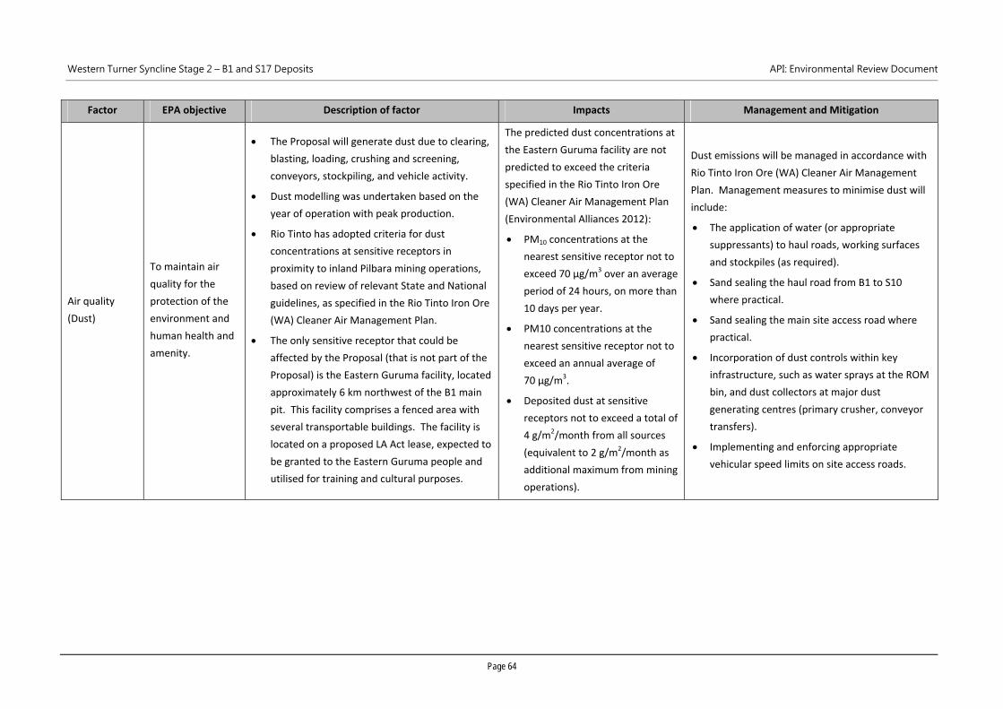
Western Turner Syncline Stage 2 – B1 and S17 Deposits API: Environmental Review Document
Page 64
Factor EPA objective Description of factor Impacts Management and Mitigation
Air quality
(Dust)
To maintain air
quality for the
protection of the
environment and
human health and
amenity.
The Proposal will generate dust due to clearing,
blasting, loading, crushing and screening,
conveyors, stockpiling, and vehicle activity.
Dust modelling was undertaken based on the
year of operation with peak production.
Rio Tinto has adopted criteria for dust
concentrations at sensitive receptors in
proximity to inland Pilbara mining operations,
based on review of relevant State and National
guidelines, as specified in the Rio Tinto Iron Ore
(WA) Cleaner Air Management Plan.
The only sensitive receptor that could be
affected by the Proposal (that is not part of the
Proposal) is the Eastern Guruma facility, located
approximately 6 km northwest of the B1 main
pit. This facility comprises a fenced area with
several transportable buildings. The facility is
located on a proposed LA Act lease, expected to
be granted to the Eastern Guruma people and
utilised for training and cultural purposes.
The predicted dust concentrations at
the Eastern Guruma facility are not
predicted to exceed the criteria
specified in the Rio Tinto Iron Ore
(WA) Cleaner Air Management Plan
(Environmental Alliances 2012):
PM10 concentrations at the
nearest sensitive receptor not to
exceed 70 µg/m3 over an average
period of 24 hours, on more than
10 days per year.
PM10 concentrations at the
nearest sensitive receptor not to
exceed an annual average of
70 µg/m3.
Deposited dust at sensitive
receptors not to exceed a total of
4 g/m2/month from all sources
(equivalent to 2 g/m2/month as
additional maximum from mining
operations).
Dust emissions will be managed in accordance with
Rio Tinto Iron Ore (WA) Cleaner Air Management
Plan. Management measures to minimise dust will
include:
The application of water (or appropriate
suppressants) to haul roads, working surfaces
and stockpiles (as required).
Sand sealing the haul road from B1 to S10
where practical.
Sand sealing the main site access road where
practical.
Incorporation of dust controls within key
infrastructure, such as water sprays at the ROM
bin, and dust collectors at major dust
generating centres (primary crusher, conveyor
transfers).
Implementing and enforcing appropriate
vehicular speed limits on site access roads.
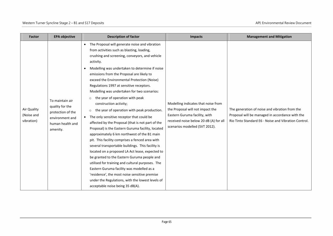
Western Turner Syncline Stage 2 – B1 and S17 Deposits API: Environmental Review Document
Page 65
Factor EPA objective Description of factor Impacts Management and Mitigation
Air Quality
(Noise and
vibration)
To maintain air
quality for the
protection of the
environment and
human health and
amenity.
The Proposal will generate noise and vibration
from activities such as blasting, loading,
crushing and screening, conveyors, and vehicle
activity.
Modelling was undertaken to determine if noise
emissions from the Proposal are likely to
exceed the Environmental Protection (Noise)
Regulations 1997 at sensitive receptors.
Modelling was undertaken for two scenarios:
o the year of operation with peak
construction activity;
o the year of operation with peak production.
The only sensitive receptor that could be
affected by the Proposal (that is not part of the
Proposal) is the Eastern Guruma facility, located
approximately 6 km northwest of the B1 main
pit. This facility comprises a fenced area with
several transportable buildings. This facility is
located on a proposed LA Act lease, expected to
be granted to the Eastern Guruma people and
utilised for training and cultural purposes. The
Eastern Guruma facility was modelled as a
'residence', the most noise sensitive premise
under the Regulations, with the lowest levels of
acceptable noise being 35 dB(A).
Modelling indicates that noise from
the Proposal will not impact the
Eastern Guruma facility, with
received noise below 20 dB (A) for all
scenarios modelled (SVT 2012).
The generation of noise and vibration from the
Proposal will be managed in accordance with the
Rio Tinto Standard E6 ‐ Noise and Vibration Control.
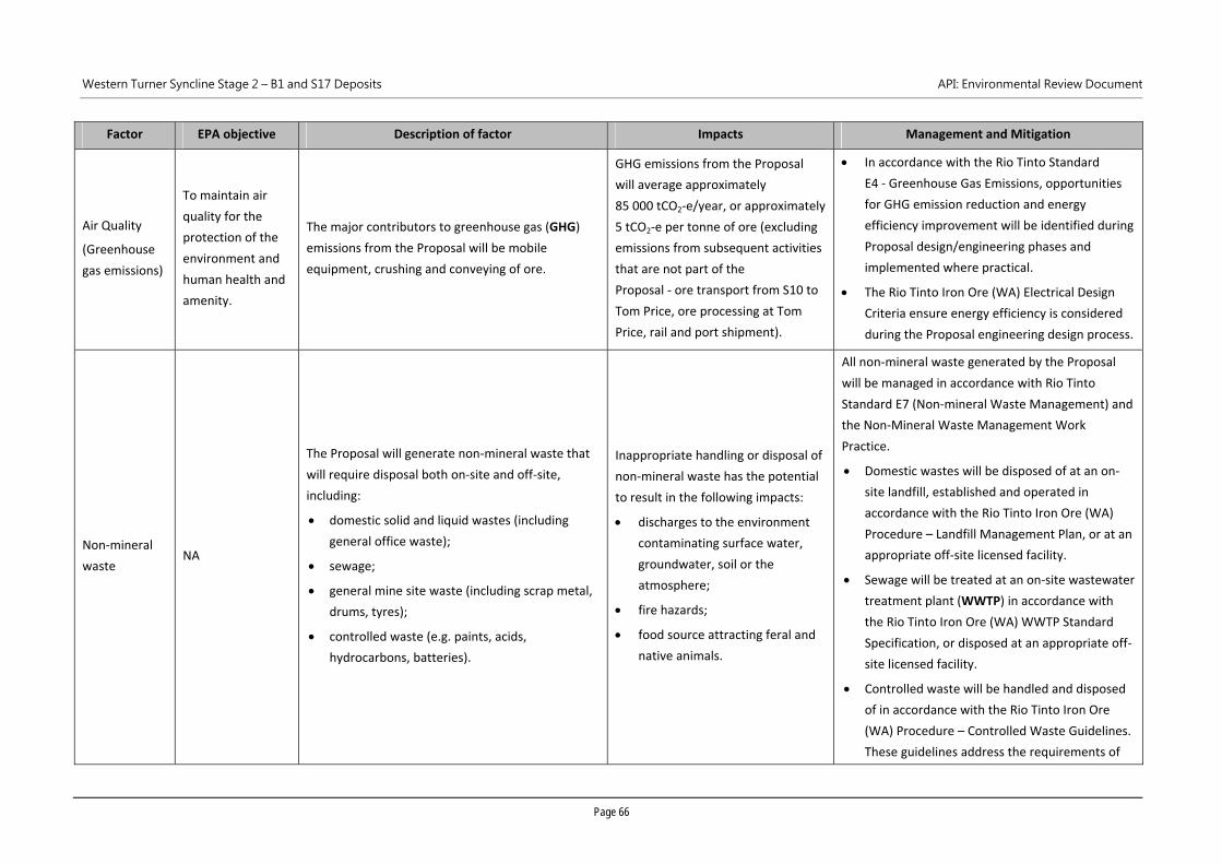
Western Turner Syncline Stage 2 – B1 and S17 Deposits API: Environmental Review Document
Page 66
Factor EPA objective Description of factor Impacts Management and Mitigation
Air Quality
(Greenhouse
gas emissions)
To maintain air
quality for the
protection of the
environment and
human health and
amenity.
The major contributors to greenhouse gas (GHG)
emissions from the Proposal will be mobile
equipment, crushing and conveying of ore.
GHG emissions from the Proposal
will average approximately
85 000 tCO2‐e/year, or approximately
5 tCO2‐e per tonne of ore (excluding
emissions from subsequent activities
that are not part of the
Proposal ‐ ore transport from S10 to
Tom Price, ore processing at Tom
Price, rail and port shipment).
In accordance with the Rio Tinto Standard
E4 ‐ Greenhouse Gas Emissions, opportunities
for GHG emission reduction and energy
efficiency improvement will be identified during
Proposal design/engineering phases and
implemented where practical.
The Rio Tinto Iron Ore (WA) Electrical Design
Criteria ensure energy efficiency is considered
during the Proposal engineering design process.
Non‐mineral
waste NA
The Proposal will generate non‐mineral waste that
will require disposal both on‐site and off‐site,
including:
domestic solid and liquid wastes (including
general office waste);
sewage;
general mine site waste (including scrap metal,
drums, tyres);
controlled waste (e.g. paints, acids,
hydrocarbons, batteries).
Inappropriate handling or disposal of
non‐mineral waste has the potential
to result in the following impacts:
discharges to the environment
contaminating surface water,
groundwater, soil or the
atmosphere;
fire hazards;
food source attracting feral and
native animals.
All non‐mineral waste generated by the Proposal
will be managed in accordance with Rio Tinto
Standard E7 (Non‐mineral Waste Management) and
the Non‐Mineral Waste Management Work
Practice.
Domestic wastes will be disposed of at an on‐
site landfill, established and operated in
accordance with the Rio Tinto Iron Ore (WA)
Procedure – Landfill Management Plan, or at an
appropriate off‐site licensed facility.
Sewage will be treated at an on‐site wastewater
treatment plant (WWTP) in accordance with
the Rio Tinto Iron Ore (WA) WWTP Standard
Specification, or disposed at an appropriate off‐
site licensed facility.
Controlled waste will be handled and disposed
of in accordance with the Rio Tinto Iron Ore
(WA) Procedure – Controlled Waste Guidelines.
These guidelines address the requirements of
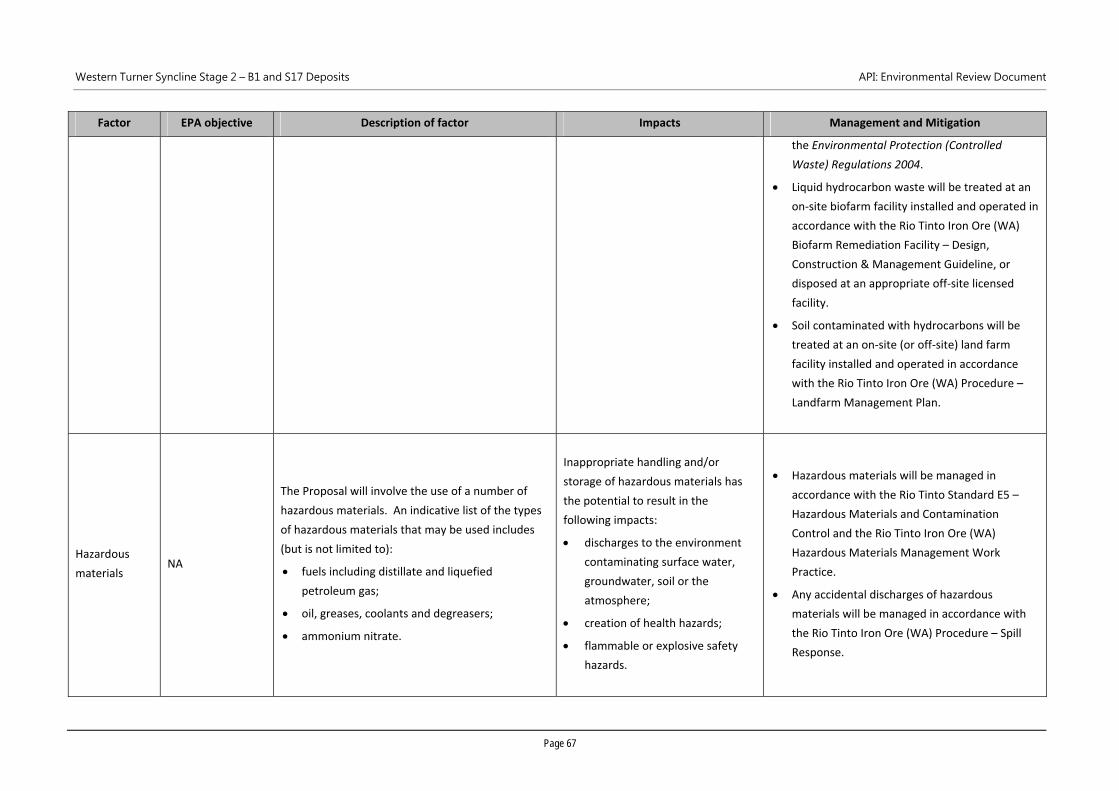
Western Turner Syncline Stage 2 – B1 and S17 Deposits API: Environmental Review Document
Page 67
Factor EPA objective Description of factor Impacts Management and Mitigation
the Environmental Protection (Controlled
Waste) Regulations 2004.
Liquid hydrocarbon waste will be treated at an
on‐site biofarm facility installed and operated in
accordance with the Rio Tinto Iron Ore (WA)
Biofarm Remediation Facility – Design,
Construction & Management Guideline, or
disposed at an appropriate off‐site licensed
facility.
Soil contaminated with hydrocarbons will be
treated at an on‐site (or off‐site) land farm
facility installed and operated in accordance
with the Rio Tinto Iron Ore (WA) Procedure –
Landfarm Management Plan.
Hazardous
materials NA
The Proposal will involve the use of a number of
hazardous materials. An indicative list of the types
of hazardous materials that may be used includes
(but is not limited to):
fuels including distillate and liquefied
petroleum gas;
oil, greases, coolants and degreasers;
ammonium nitrate.
Inappropriate handling and/or
storage of hazardous materials has
the potential to result in the
following impacts:
discharges to the environment
contaminating surface water,
groundwater, soil or the
atmosphere;
creation of health hazards;
flammable or explosive safety
hazards.
Hazardous materials will be managed in
accordance with the Rio Tinto Standard E5 –
Hazardous Materials and Contamination
Control and the Rio Tinto Iron Ore (WA)
Hazardous Materials Management Work
Practice.
Any accidental discharges of hazardous
materials will be managed in accordance with
the Rio Tinto Iron Ore (WA) Procedure – Spill
Response.
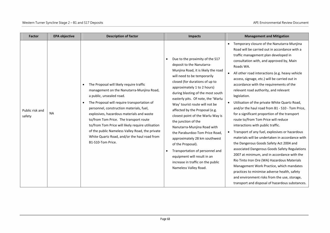
Western Turner Syncline Stage 2 – B1 and S17 Deposits API: Environmental Review Document
Page 68
Factor EPA objective Description of factor Impacts Management and Mitigation
Public risk and
safety NA
The Proposal will likely require traffic
management on the Nanutarra‐Munjina Road,
a public, unsealed road.
The Proposal will require transportation of
personnel, construction materials, fuel,
explosives, hazardous materials and waste
to/from Tom Price. The transport route
to/from Tom Price will likely require utilisation
of the public Nameless Valley Road, the private
White Quartz Road, and/or the haul road from
B1‐S10‐Tom Price.
Due to the proximity of the S17
deposit to the Nanutarra‐
Munjina Road, it is likely the road
will need to be temporarily
closed (for durations of up to
approximately 1 to 2 hours)
during blasting of the most south
easterly pits. Of note, the ‘Warlu
Way’ tourist route will not be
affected by the Proposal (e.g.
closest point of the Warlu Way is
the junction of the
Nanutarra‐Munjina Road with
the Paraburdoo‐Tom Price Road,
approximately 28 km southwest
of the Proposal).
Transportation of personnel and
equipment will result in an
increase in traffic on the public
Nameless Valley Road.
Temporary closure of the Nanutarra‐Munjina
Road will be carried out in accordance with a
traffic management plan developed in
consultation with, and approved by, Main
Roads WA.
All other road interactions (e.g. heavy vehicle
access, signage, etc.) will be carried out in
accordance with the requirements of the
relevant road authority, and relevant
legislation.
Utilisation of the private White Quartz Road,
and/or the haul road from B1 ‐ S10 ‐ Tom Price,
for a significant proportion of the transport
route to/from Tom Price will reduce
interactions with public traffic.
Transport of any fuel, explosives or hazardous
materials will be undertaken in accordance with
the Dangerous Goods Safety Act 2004 and
associated Dangerous Goods Safety Regulations
2007 at minimum, and in accordance with the
Rio Tinto Iron Ore (WA) Hazardous Materials
Management Work Practice, which mandates
practices to minimise adverse health, safety
and environment risks from the use, storage,
transport and disposal of hazardous substances.
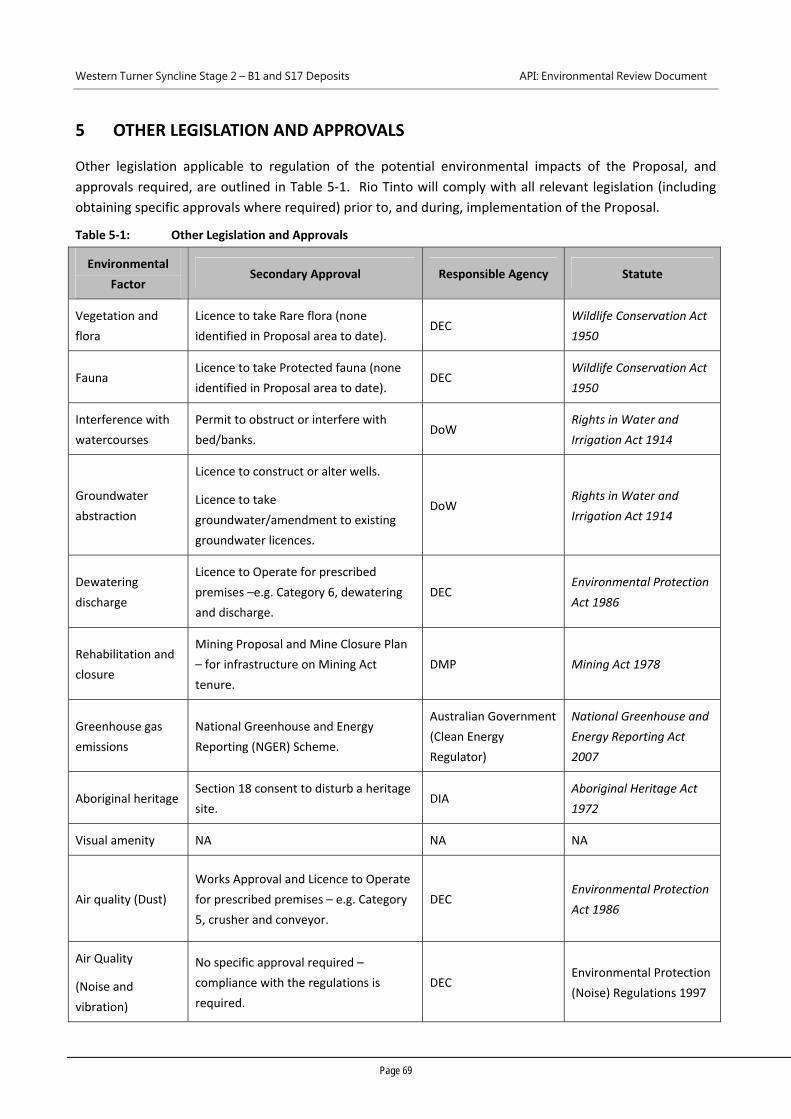
Western Turner Syncline Stage 2 – B1 and S17 Deposits API: Environmental Review Document
Page 69
5 OTHER LEGISLATION AND APPROVALS
Other legislation applicable to regulation of the potential environmental impacts of the Proposal, and
approvals required, are outlined in Table 5‐1. Rio Tinto will comply with all relevant legislation (including
obtaining specific approvals where required) prior to, and during, implementation of the Proposal.
Table 5‐1: Other Legislation and Approvals
Environmental
Factor Secondary Approval Responsible Agency Statute
Vegetation and
flora
Licence to take Rare flora (none
identified in Proposal area to date). DEC
Wildlife Conservation Act
1950
Fauna Licence to take Protected fauna (none
identified in Proposal area to date). DEC
Wildlife Conservation Act
1950
Interference with
watercourses
Permit to obstruct or interfere with
bed/banks. DoW
Rights in Water and
Irrigation Act 1914
Groundwater
abstraction
Licence to construct or alter wells.
Licence to take
groundwater/amendment to existing
groundwater licences.
DoW Rights in Water and
Irrigation Act 1914
Dewatering
discharge
Licence to Operate for prescribed
premises –e.g. Category 6, dewatering
and discharge.
DEC Environmental Protection
Act 1986
Rehabilitation and
closure
Mining Proposal and Mine Closure Plan
– for infrastructure on Mining Act
tenure.
DMP Mining Act 1978
Greenhouse gas
emissions
National Greenhouse and Energy
Reporting (NGER) Scheme.
Australian Government
(Clean Energy
Regulator)
National Greenhouse and
Energy Reporting Act
2007
Aboriginal heritage Section 18 consent to disturb a heritage
site. DIA
Aboriginal Heritage Act
1972
Visual amenity NA NA NA
Air quality (Dust)
Works Approval and Licence to Operate
for prescribed premises – e.g. Category
5, crusher and conveyor.
DEC Environmental Protection
Act 1986
Air Quality
(Noise and
vibration)
No specific approval required –
compliance with the regulations is
required.
DEC Environmental Protection
(Noise) Regulations 1997
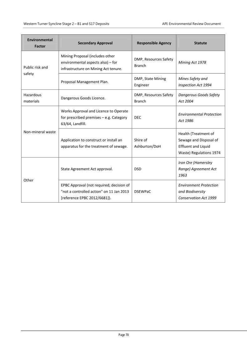
Western Turner Syncline Stage 2 – B1 and S17 Deposits API: Environmental Review Document
Page 70
Environmental
Factor Secondary Approval Responsible Agency Statute
Public risk and
safety
Mining Proposal (includes other
environmental aspects also) – for
infrastructure on Mining Act tenure.
DMP, Resources Safety
Branch Mining Act 1978
Proposal Management Plan. DMP, State Mining
Engineer
Mines Safety and
Inspection Act 1994
Hazardous
materials Dangerous Goods Licence.
DMP, Resources Safety
Branch
Dangerous Goods Safety
Act 2004
Non‐mineral waste
Works Approval and Licence to Operate
for prescribed premises – e.g. Category
63/64, Landfill.
DEC Environmental Protection
Act 1986
Application to construct or install an
apparatus for the treatment of sewage.
Shire of
Ashburton/DoH
Health (Treatment of
Sewage and Disposal of
Effluent and Liquid
Waste) Regulations 1974
Other
State Agreement Act approval. DSD
Iron Ore (Hamersley
Range) Agreement Act
1963
EPBC Approval (not required; decision of
"not a controlled action" on 11 Jan 2013
[reference EPBC 2012/6681]).
DSEWPaC
Environment Protection
and Biodiversity
Conservation Act 1999
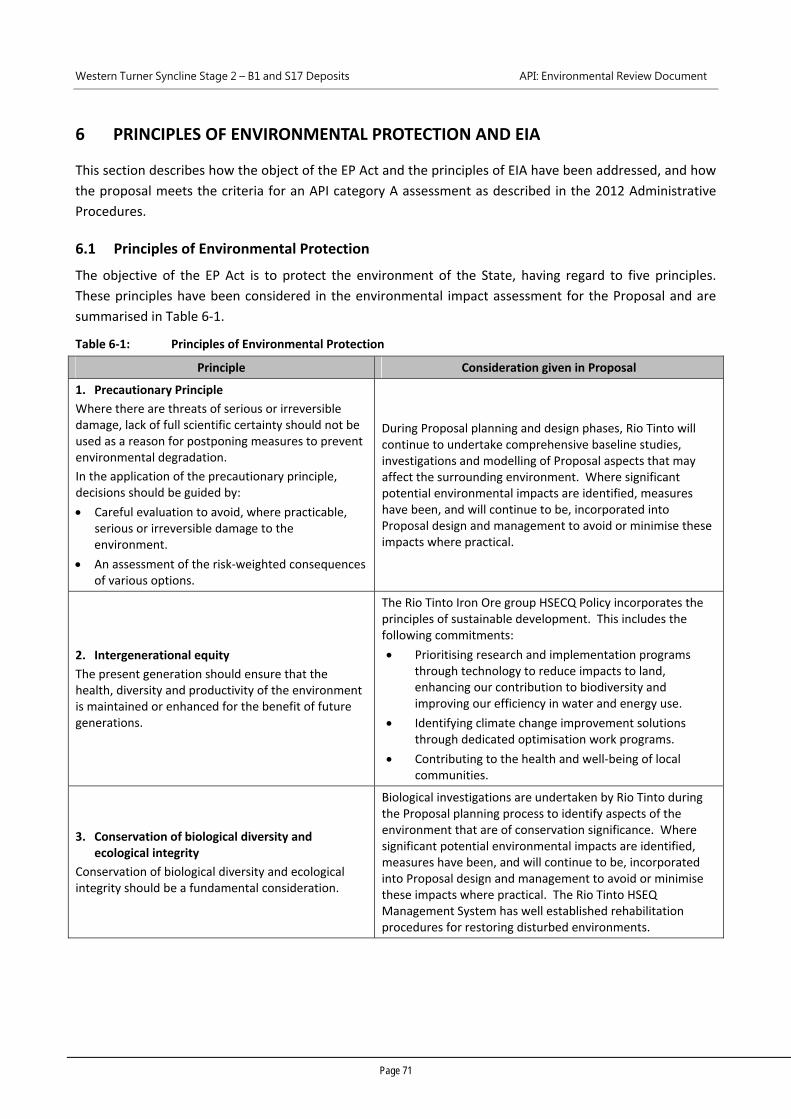
Western Turner Syncline Stage 2 – B1 and S17 Deposits API: Environmental Review Document
Page 71
6 PRINCIPLES OF ENVIRONMENTAL PROTECTION AND EIA
This section describes how the object of the EP Act and the principles of EIA have been addressed, and how
the proposal meets the criteria for an API category A assessment as described in the 2012 Administrative
Procedures.
6.1 Principles of Environmental Protection
The objective of the EP Act is to protect the environment of the State, having regard to five principles.
These principles have been considered in the environmental impact assessment for the Proposal and are
summarised in Table 6‐1.
Table 6‐1: Principles of Environmental Protection
Principle Consideration given in Proposal
1. Precautionary Principle
Where there are threats of serious or irreversible damage, lack of full scientific certainty should not be used as a reason for postponing measures to prevent environmental degradation.
In the application of the precautionary principle, decisions should be guided by:
Careful evaluation to avoid, where practicable, serious or irreversible damage to the environment.
An assessment of the risk‐weighted consequences of various options.
During Proposal planning and design phases, Rio Tinto will continue to undertake comprehensive baseline studies, investigations and modelling of Proposal aspects that may affect the surrounding environment. Where significant potential environmental impacts are identified, measures have been, and will continue to be, incorporated into Proposal design and management to avoid or minimise these impacts where practical.
2. Intergenerational equity
The present generation should ensure that the health, diversity and productivity of the environment is maintained or enhanced for the benefit of future generations.
The Rio Tinto Iron Ore group HSECQ Policy incorporates the principles of sustainable development. This includes the following commitments:
Prioritising research and implementation programs through technology to reduce impacts to land, enhancing our contribution to biodiversity and improving our efficiency in water and energy use.
Identifying climate change improvement solutions through dedicated optimisation work programs.
Contributing to the health and well‐being of local communities.
3. Conservation of biological diversity and ecological integrity
Conservation of biological diversity and ecological integrity should be a fundamental consideration.
Biological investigations are undertaken by Rio Tinto during the Proposal planning process to identify aspects of the environment that are of conservation significance. Where significant potential environmental impacts are identified, measures have been, and will continue to be, incorporated into Proposal design and management to avoid or minimise these impacts where practical. The Rio Tinto HSEQ Management System has well established rehabilitation procedures for restoring disturbed environments.
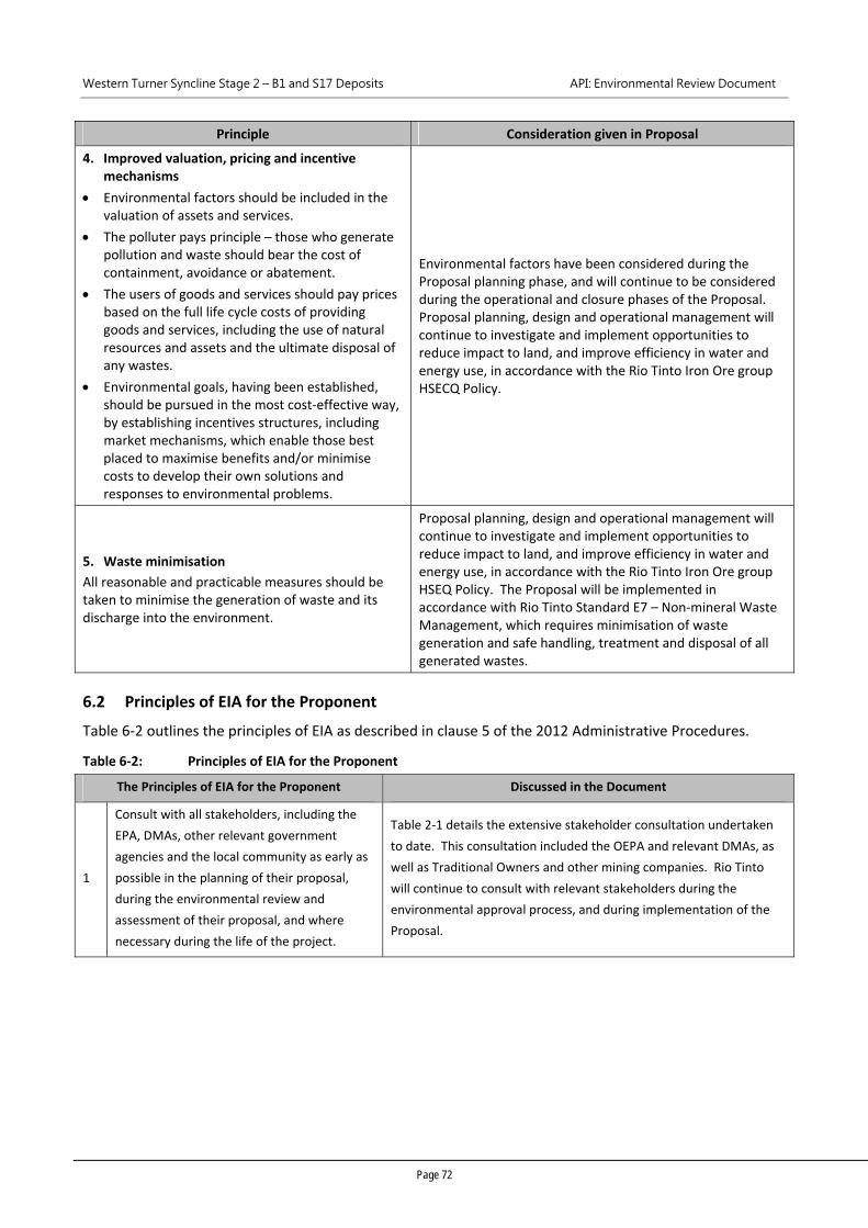
Western Turner Syncline Stage 2 – B1 and S17 Deposits API: Environmental Review Document
Page 72
Principle Consideration given in Proposal
4. Improved valuation, pricing and incentive mechanisms
Environmental factors should be included in the valuation of assets and services.
The polluter pays principle – those who generate pollution and waste should bear the cost of containment, avoidance or abatement.
The users of goods and services should pay prices based on the full life cycle costs of providing goods and services, including the use of natural resources and assets and the ultimate disposal of any wastes.
Environmental goals, having been established, should be pursued in the most cost‐effective way, by establishing incentives structures, including market mechanisms, which enable those best placed to maximise benefits and/or minimise costs to develop their own solutions and responses to environmental problems.
Environmental factors have been considered during the Proposal planning phase, and will continue to be considered during the operational and closure phases of the Proposal. Proposal planning, design and operational management will continue to investigate and implement opportunities to reduce impact to land, and improve efficiency in water and energy use, in accordance with the Rio Tinto Iron Ore group HSECQ Policy.
5. Waste minimisation
All reasonable and practicable measures should be taken to minimise the generation of waste and its discharge into the environment.
Proposal planning, design and operational management will continue to investigate and implement opportunities to reduce impact to land, and improve efficiency in water and energy use, in accordance with the Rio Tinto Iron Ore group HSEQ Policy. The Proposal will be implemented in accordance with Rio Tinto Standard E7 – Non‐mineral Waste Management, which requires minimisation of waste generation and safe handling, treatment and disposal of all generated wastes.
6.2 Principles of EIA for the Proponent
Table 6‐2 outlines the principles of EIA as described in clause 5 of the 2012 Administrative Procedures.
Table 6‐2: Principles of EIA for the Proponent
The Principles of EIA for the Proponent Discussed in the Document
1
Consult with all stakeholders, including the
EPA, DMAs, other relevant government
agencies and the local community as early as
possible in the planning of their proposal,
during the environmental review and
assessment of their proposal, and where
necessary during the life of the project.
Table 2‐1 details the extensive stakeholder consultation undertaken
to date. This consultation included the OEPA and relevant DMAs, as
well as Traditional Owners and other mining companies. Rio Tinto
will continue to consult with relevant stakeholders during the
environmental approval process, and during implementation of the
Proposal.
Western Turner Syncline Stage 2 – B1 and S17 Deposits API: Environmental Review Document
Page 73
The Principles of EIA for the Proponent Discussed in the Document
2
Ensure the public is provided with sufficient
information relevant to the EIA of a proposal
to be able to make informed comment, prior
to the EPA completing the assessment report.
Table 3‐2 to Table 3‐9 provide an EIA of the Proposal, for the
preliminary key environmental factors identified by the EPA, based
on:
a summary of the key findings of studies and investigations (full
reports provided as appendices);
assessment of potential impacts of the Proposal;
key environmental management measures.
Table 4‐1 provides a brief EIA of the Proposal for other environmental
factors.
3
Use best practicable measures and genuine
evaluation of options or alternatives in
locating, planning and designing their
proposal to mitigate detrimental
environmental impacts and to facilitate
positive environmental outcomes and a
continuous improvement approach to
environmental management.
As stated in Table 3‐2 to Table 3‐9, avoiding and minimising impacts
to the environment where practical is a key management
commitment for the Proposal, and has been implemented during
Proposal design. For example, modification of the Proposal boundary
since referral has been undertaken, to exclude extensive areas of
vegetation of elevated conservation significance, and several
occurrences of a Priority 1 flora species (Table 3‐2 and Figure 1‐5).
As detailed in Section 3.2, continuous improvement is a key aspect of
the Rio Tinto Iron Ore (WA) HSEQ Management System.
4
Identify the environmental factors likely to be
impacted and the aspects likely to cause
impacts in the early stages of planning for
their proposal. The onus is on the proponent
through the EIA process to demonstrate that
the unavoidable impacts will meet the EPA
objectives for environmental factors and
therefore their proposal is environmentally
acceptable.
Table 3‐2 to Table 3‐9 identifies the preliminary key environmental
factors relevant to the Proposal, potential impacts, key management
measures, and how the EPA objectives relevant to each
environmental factor can be met by the Proposal.
Table 4‐1 provides a brief EIA of the Proposal for other environmental
factors.
5
Consider the following, during project
planning and discussions with the EPA,
regarding the form, content and timing of
their environmental review:
a. The activities, investigations (and
consequent authorisations) required to
undertake the environmental review.
b. The efficacy of the investigations to
produce sound scientific baseline data
about the receiving environment.
c. The documentation and reporting of
investigations.
d. The likely timeframes in which to
complete the environmental review;
e. Use best endeavours to meet
assessment timelines.
The form and content of the environmental review has incorporated
advice provided by the OEPA in several meetings, and addressed
OEPA comment on drafts of the environmental review.
Comprehensive studies and investigations, of high standard, have
been undertaken to support the environmental review, and are
provided as appendices.
Project planning has considered the expected timeframes for
completion of supporting studies, environmental review preparation
and assessment, and timings for key milestones are regularly
discussed with the OEPA.
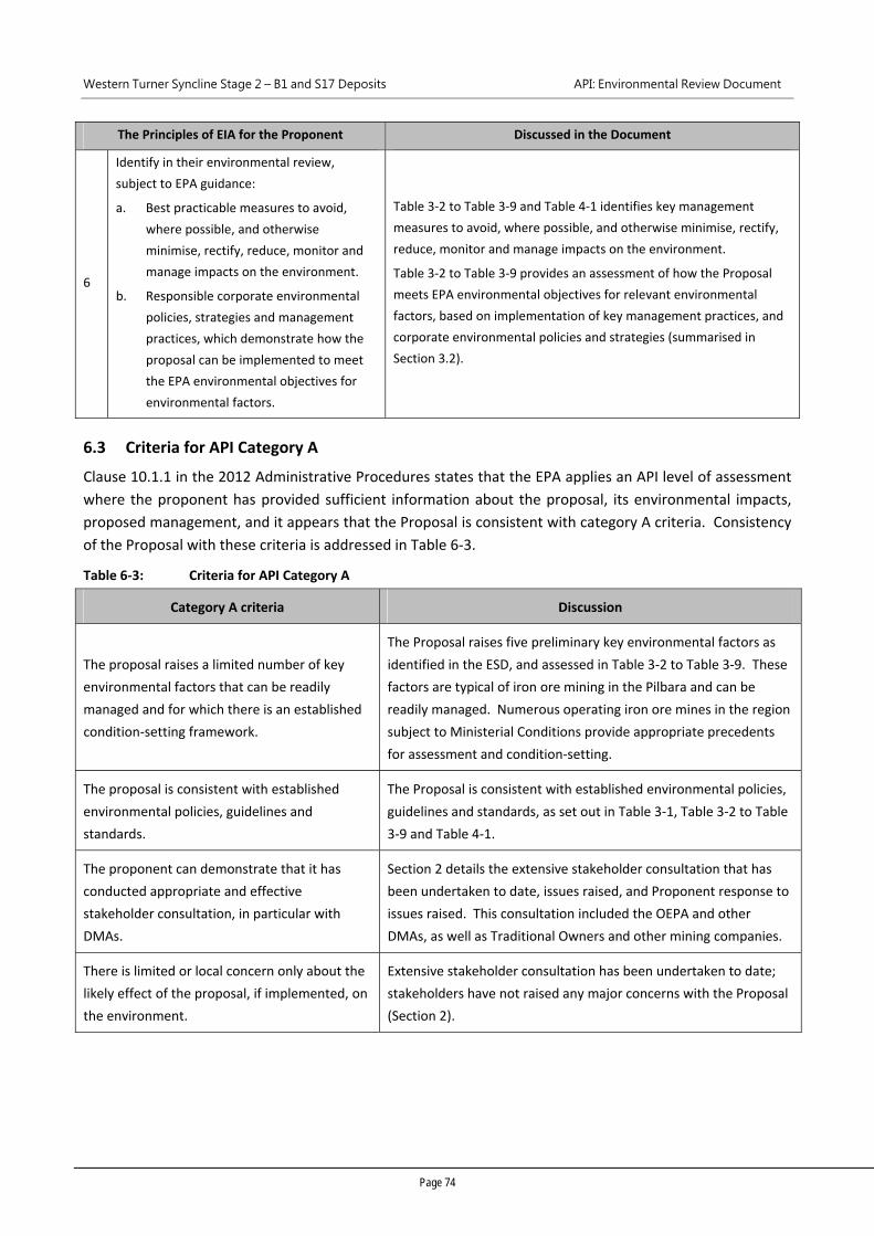
Western Turner Syncline Stage 2 – B1 and S17 Deposits API: Environmental Review Document
Page 74
The Principles of EIA for the Proponent Discussed in the Document
6
Identify in their environmental review,
subject to EPA guidance:
a. Best practicable measures to avoid,
where possible, and otherwise
minimise, rectify, reduce, monitor and
manage impacts on the environment.
b. Responsible corporate environmental
policies, strategies and management
practices, which demonstrate how the
proposal can be implemented to meet
the EPA environmental objectives for
environmental factors.
Table 3‐2 to Table 3‐9 and Table 4‐1 identifies key management
measures to avoid, where possible, and otherwise minimise, rectify,
reduce, monitor and manage impacts on the environment.
Table 3‐2 to Table 3‐9 provides an assessment of how the Proposal
meets EPA environmental objectives for relevant environmental
factors, based on implementation of key management practices, and
corporate environmental policies and strategies (summarised in
Section 3.2).
6.3 Criteria for API Category A
Clause 10.1.1 in the 2012 Administrative Procedures states that the EPA applies an API level of assessment
where the proponent has provided sufficient information about the proposal, its environmental impacts,
proposed management, and it appears that the Proposal is consistent with category A criteria. Consistency
of the Proposal with these criteria is addressed in Table 6‐3.
Table 6‐3: Criteria for API Category A
Category A criteria Discussion
The proposal raises a limited number of key
environmental factors that can be readily
managed and for which there is an established
condition‐setting framework.
The Proposal raises five preliminary key environmental factors as
identified in the ESD, and assessed in Table 3‐2 to Table 3‐9. These
factors are typical of iron ore mining in the Pilbara and can be
readily managed. Numerous operating iron ore mines in the region
subject to Ministerial Conditions provide appropriate precedents
for assessment and condition‐setting.
The proposal is consistent with established
environmental policies, guidelines and
standards.
The Proposal is consistent with established environmental policies,
guidelines and standards, as set out in Table 3‐1, Table 3‐2 to Table
3‐9 and Table 4‐1.
The proponent can demonstrate that it has
conducted appropriate and effective
stakeholder consultation, in particular with
DMAs.
Section 2 details the extensive stakeholder consultation that has
been undertaken to date, issues raised, and Proponent response to
issues raised. This consultation included the OEPA and other
DMAs, as well as Traditional Owners and other mining companies.
There is limited or local concern only about the
likely effect of the proposal, if implemented, on
the environment.
Extensive stakeholder consultation has been undertaken to date;
stakeholders have not raised any major concerns with the Proposal
(Section 2).
Western Turner Syncline Stage 2 – B1 and S17 Deposits API: Environmental Review Document
Page 75
7 REFERENCES
Australian and New Zealand Environment and Conservation Council & Agriculture and Resource
Management Council of Australia and New Zealand (ANZECC/ARMCANZ) 2000, Australian and New
Zealand Guidelines for Fresh and Marine Water Quality, Australian Water Association, Sydney.
Beard JS 1975, Pilbara Explanatory Notes and Map Sheet, 1:1,000,000 Series, Vegetation Survey of Western
Australia, University of Western Australia Press, Nedlands.
Biota Environmental Sciences (Biota) 2007, A Vegetation and Flora Survey of the West Turner Section 10
Area and Infrastructure Corridor, unpublished report prepared for Rio Tinto, RTIO‐HSE‐0063557,
Perth.
Biota Environmental Sciences (Biota) 2009a, West Turner Syncline Section 10 Development Two‐Phase
Fauna Survey, unpublished report prepared for Rio Tinto, RTIO‐HSE‐0123438, Perth.
Biota Environmental Sciences (Biota) 2009b, A Two‐Phase Fauna Survey of the West Turner Syncline Area,
unpublished report prepared for Rio Tinto, RTIO‐HSE‐0063545, Perth.
Biota Environmental Sciences (Biota) 2011a, West Turner Targeted Fauna Survey, unpublished report
prepared for Rio Tinto Iron Ore, RTIO‐HSE‐0131480, Perth.
Biota Environmental Sciences (Biota) 2011b, West Turner Syncline Section 10 Expanded Vegetation and
Flora Survey Report, unpublished report prepared for Rio Tinto, RTIO‐HSE‐0123440, Perth.
Biota Environmental Sciences (Biota) 2012a, West Turner Syncline NES Species Assessment, unpublished
report prepared for Rio Tinto, RTIO‐HSE‐0164398, Perth.
Biota Environmental Sciences (Biota) 2012b, West Turner Syncline Fauna Survey Summary Report,
unpublished report prepared for Rio Tinto, RTIO‐HSE‐0164353, Perth.
Biota Environmental Sciences (Biota) 2012c, West Turner Syncline Stage 2 B1 and Section 17 Deposits
Subterranean Fauna Survey, unpublished report for Rio Tinto, RTIO‐HSE‐0159400, Perth.
Biota Environmental Sciences (Biota) 2013a, West Turner Syncline Phase 2 Vegetation and Flora Report,
unpublished report prepared for Rio Tinto, RTIO‐HSE‐0164513, Perth.
Biota Environmental Sciences (Biota) 2013b, West Turner Syncline Stage 2 – Phase 1 Survey and Targeted
Vegetation Survey, unpublished report for Rio Tinto, RTIO‐HSE‐0164845, Perth.
Commonwealth of Australia (Commonwealth) 2007, Leading Practice Sustainable Development Program for
the Mining Industry, Managing Acid and Metalliferous Drainage, Commonwealth of Australia,
Canberra.
Department of Water (DoW) 2009, Pilbara Water in Mining Guideline, Report no. 34, Department of Water,
Perth
Department of Mines and Petroleum and the Environmental Protection Authority (DMP/EPA) 2011,
Guidelines for Preparing Mine Closure Plans, Department of Mines and Petroleum, Perth.
Department of Planning and Infrastructure (DPI) (2007) Visual Landscape Planning in Western Australia: a
manual for evaluation, assessment, siting and design. Western Australian Planning Commission,
Perth.
Western Turner Syncline Stage 2 – B1 and S17 Deposits API: Environmental Review Document
Page 76
Ecoscape (Australia) Pty Ltd (Ecoscape) 2012, Western Turner Syncline Stage 2 Visual Impact Assessment,
unpublished report for Rio Tinto, RTIO‐HSE‐0159656, Perth.
Environmental Alliances 2012, Predicted Dust Levels from Western Turner Syncline Stage 2 (B1 and S17) Iron
Ore Project, unpublished report for Rio Tinto, RTIO‐HSE‐0160666, Perth.
Environmental Protection Authority (EPA) 2003, Consideration of Subterranean Fauna in Groundwater and
Caves during EIA in WA, Guidance Statement No. 54, published by the Environmental Protection
Authority, Perth.
Environmental Protection Authority (EPA) 2004a, Terrestrial Flora and Vegetation Surveys for
Environmental Impact Assessment in Western Australia, Guidance Statement No. 51, published by
the Environmental Protection Authority, Perth.
Environmental Protection Authority (EPA) 2004b, Terrestrial Fauna Surveys for Environmental Impact
Assessment in Western Australia, EPA Guidance Statement No. 56, published by the Environmental
Protection Authority, Perth.
Environmental Protection Authority (EPA) 2006, Environmental Offsets, Position Statement No. 9, published
by the Environmental Protection Authority, Perth.
Environmental Protection Authority (EPA) 2007a, Sampling methods and survey considerations for
subterranean fauna in Western Australia, Draft EPA Guidance Statement No. 54a, published by the
Environmental Protection Authority, Perth.
Environmental Protection Authority (EPA) 2007b, Environmental Noise, Draft Guidance Statement No.8,
published by the Environmental Protection Authority, Perth.
Environmental Protection Authority (EPA) 2008, Environmental Offsets – Biodiversity, Guidance Statement
No. 19, published by the Environmental Protection Authority, Perth.
Environmental Protection Authority (EPA) 2009, Sampling of Short Range Endemic Invertebrate Fauna for
Environmental Impact Assessment in Western Australia, EPA Guidance Statement No. 20, published by
the Environmental Protection Authority, Perth.
Environmental Protection Authority and Department of Environment and Conservation (EPA/DEC) 2010,
Technical Guide ‐ Terrestrial Vertebrate Fauna Surveys for Environmental Impact Assessment,
published by the Environmental Protection Authority, Perth.
Equinox Environmental 2012, Western Turner Syncline Stage 2 Project Ecological Risk Assessment,
unpublished report for Rio Tinto, RTIO‐HSE‐0168076, Perth.
Klohn Crippen Berger (KCB) 2012a, Western Turner Syncline B1 Pit Post Closure Water Quality Assessment,
unpublished report for Rio Tinto, RTIO‐HSE‐0145681, Perth.
Klohn Crippen Berger (KCB) 2012b, WTS2 B1 Water Quality Assessment, unpublished report for Rio Tinto,
RTIO‐PDE‐0102103, Perth.
MWH 2009, B1 Groundwater Model: A transient numerical groundwater model of the dewatering of the
proposed B1 mine site in the Western Turner Syncline using MODFLOW 2000, unpublished report
for Rio Tinto, RTIO‐PDE‐0062664, Perth.
Western Turner Syncline Stage 2 – B1 and S17 Deposits API: Environmental Review Document
Page 77
Rio Tinto 2011, Groundwater Dependant Ecosystems in the Pilbara and predicted impacts from dewatering
and discharge along Caves and Duck Creek, internal memo prepared by Rio Tinto Iron Ore, RTIO‐
HSE‐0166230, Perth.
Rio Tinto 2012a, Baseline hydrology assessment for a local creek discharge from Western Turner Syncline
(WTS) B1 deposit, unpublished report prepared by Rio Tinto, RTIO‐HSE‐0095090, Perth.
Rio Tinto 2012b, Western Turner Syncline B1 Dewatering Strategy – Groundwater Numerical Modelling,
unpublished report prepared by Rio Tinto, RTIO‐PDE‐0092036, Perth.
Rio Tinto 2012c, WTS Phase II Surface Water Management, unpublished report prepared by Rio Tinto,
RTIO‐PDE‐0101051, Perth.
Rio Tinto 2012d, Western Turner Syncline B1 – Feasibility Studies Groundwater Modelling: Dewatering and
Closure, unpublished report prepared by Rio Tinto, RTIO‐PDE‐0103028, Perth.
Rio Tinto 2012e, Surface hydrology in the vicinity of the WTS2 infrastructure corridor between WTS B1 and
S10; assessment and modelling of natural surface flows, unpublished report prepared by Rio Tinto,
RTIO‐PDE‐0103316, Perth.
Rio Tinto 2012f, Western Turner Syncline B1 and S17 AMD Risk Assessment, November 2012, unpublished
report prepared by Rio Tinto, RTIO‐PDE‐0102519, Perth.
Rio Tinto 2012g, Western Turner Syncline (Stage 2) Closure Plan, unpublished report prepared by Rio Tinto,
Perth.
Rio Tinto 2013a, Western Turner Syncline B1 – Feasibility Study Groundwater Modelling: Dewatering and
Closure, unpublished report prepared by Rio Tinto, RTIO‐PDE‐0104666, Perth.
Rio Tinto 2013b, WTS Stage 2 FS – Water balance & strategy update, unpublished report prepared by Rio
Tinto, Perth.
SVT Engineering Consultants (SVT) 2012, Environmental Noise Assessment of Western Turner Syncline Stage
II Project, unpublished report for Rio Tinto, RTIO‐HSE‐0160668, Perth.
University of Western Australia (UWA) 2012a, West Turner Syncline Stage 2 ‐ Potential impacts of mining
operations on overland flow dependent vegetation ‐ Preliminary assessment, unpublished report for
Rio Tinto, RTIO‐HSE‐0159807, Perth.
University of Western Australia (UWA) 2012b, West Turner Syncline Stage 2 ‐ Potential impacts of mining
operations on groundwater dependent vegetation ‐ Preliminary assessment, unpublished report for
Rio Tinto, RTIO‐HSE‐0159544, Perth.
URS 2009, Western Turner Syncline Hydrogeological Bore Completion Report, unpublished report prepared
for Rio Tinto, RTIO‐PDE‐0061401, Perth.
Wetland Research and Management (WRM) 2012a, Western Turner Syncline: Baseline Assessment of
Aquatic Fauna & Water Quality – Wet & Dry 2011 Survey, unpublished report prepared for Rio
Tinto, RTIO‐HSE‐0134269, Perth.
Wetland Research and Management (WRM) 2012b, WTS2 – groundwater quality – updated data,
unpublished report prepared for Rio Tinto, RTIO‐HSE‐0166326, Perth.


Western Turner Syncline Stage 2 – B1 and S17 Deposits API: Environmental Review Document
Page 79
Appendix 1 Supporting Tables
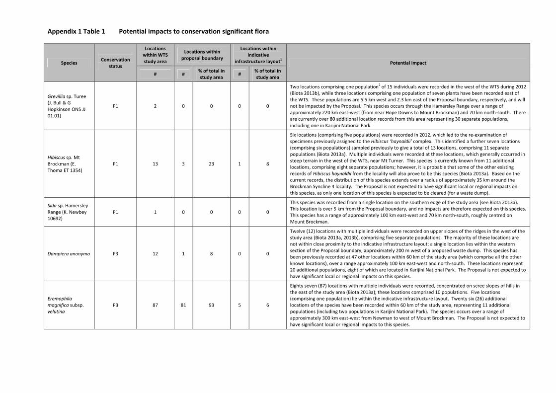
Appendix 1 Table 1 Potential impacts to conservation significant flora
Species Conservation
status
Locations within WTS study area
Locations within proposal boundary
Locations within indicative
infrastructure layout1 Potential impact
# # % of total in study area
# % of total in study area
Grevillia sp. Turee (J. Bull & G Hopkinson ONS JJ 01.01)
P1 2 0 0 0 0
Two locations comprising one population2 of 15 individuals were recorded in the west of the WTS during 2012
(Biota 2013b), while three locations comprising one population of seven plants have been recorded east of the WTS. These populations are 5.5 km west and 2.3 km east of the Proposal boundary, respectively, and will not be impacted by the Proposal. This species occurs through the Hamersley Range over a range of approximately 220 km east‐west (from near Hope Downs to Mount Brockman) and 70 km north‐south. There are currently over 80 additional location records from this area representing 30 separate populations, including one in Karijini National Park.
Hibiscus sp. Mt Brockman (E. Thoma ET 1354)
P1 13 3 23 1 8
Six locations (comprising five populations) were recorded in 2012, which led to the re‐examination of specimens previously assigned to the Hibiscus ‘haynaldii’ complex. This identified a further seven locations (comprising six populations) sampled previously to give a total of 13 locations, comprising 11 separate populations (Biota 2013a). Multiple individuals were recorded at these locations, which generally occurred in steep terrain in the west of the WTS, near Mt Turner. This species is currently known from 11 additional locations, comprising eight separate populations; however, it is probable that some of the other existing records of Hibiscus haynaldii from the locality will also prove to be this species (Biota 2013a). Based on the current records, the distribution of this species extends over a radius of approximately 35 km around the Brockman Syncline 4 locality. The Proposal is not expected to have significant local or regional impacts on this species, as only one location of this species is expected to be cleared (for a waste dump).
Sida sp. Hamersley Range (K. Newbey 10692)
P1 1 0 0 0 0
This species was recorded from a single location on the southern edge of the study area (see Biota 2013a). This location is over 5 km from the Proposal boundary, and no impacts are therefore expected on this species. This species has a range of approximately 100 km east‐west and 70 km north‐south, roughly centred on Mount Brockman.
Dampiera anonyma P3 12 1 8 0 0
Twelve (12) locations with multiple individuals were recorded on upper slopes of the ridges in the west of the study area (Biota 2013a, 2013b), comprising five separate populations. The majority of these locations are not within close proximity to the indicative infrastructure layout; a single location lies within the western section of the Proposal boundary, approximately 200 m west of a proposed waste dump. This species has been previously recorded at 47 other locations within 60 km of the study area (which comprise all the other known locations), over a range approximately 100 km east‐west and north‐south. These locations represent 20 additional populations, eight of which are located in Karijini National Park. The Proposal is not expected to have significant local or regional impacts on this species.
Eremophila magnifica subsp. velutina
P3 87 81 93 5 6
Eighty seven (87) locations with multiple individuals were recorded, concentrated on scree slopes of hills in the east of the study area (Biota 2013a); these locations comprised 10 populations. Five locations (comprising one population) lie within the indicative infrastructure layout. Twenty six (26) additional locations of the species have been recorded within 60 km of the study area, representing 11 additional populations (including two populations in Karijini National Park). The species occurs over a range of approximately 300 km east‐west from Newman to west of Mount Brockman. The Proposal is not expected to have significant local or regional impacts to this species.
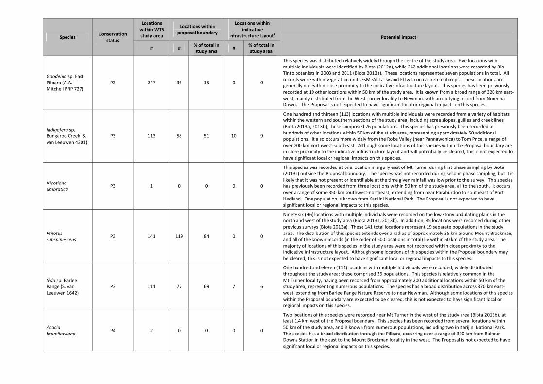
Species Conservation
status
Locations within WTS study area
Locations within proposal boundary
Locations within indicative
infrastructure layout1 Potential impact
# # % of total in study area
# % of total in study area
Goodenia sp. East Pilbara (A.A. Mitchell PRP 727)
P3 247 36 15 0 0
This species was distributed relatively widely through the centre of the study area. Five locations with multiple individuals were identified by Biota (2012a), while 242 additional locations were recorded by Rio Tinto botanists in 2003 and 2011 (Biota 2013a). These locations represented seven populations in total. All records were within vegetation units EsMeAbTaTw and ElTwTa on calcrete outcrops. These locations are generally not within close proximity to the indicative infrastructure layout. This species has been previously recorded at 19 other locations within 50 km of the study area. It is known from a broad range of 320 km east‐west, mainly distributed from the West Turner locality to Newman, with an outlying record from Noreena Downs. The Proposal is not expected to have significant local or regional impacts on this species.
Indigofera sp. Bungaroo Creek (S. van Leeuwen 4301)
P3 113 58 51 10 9
One hundred and thirteen (113) locations with multiple individuals were recorded from a variety of habitats within the western and southern sections of the study area, including scree slopes, gullies and creek lines (Biota 2013a, 2013b); these comprised 26 populations. This species has previously been recorded at hundreds of other locations within 50 km of the study area, representing approximately 50 additional populations. It also occurs more widely from the Robe Valley (near Pannawonica) to Tom Price, a range of over 200 km northwest‐southeast. Although some locations of this species within the Proposal boundary are in close proximity to the indicative infrastructure layout and will potentially be cleared, this is not expected to have significant local or regional impacts on this species.
Nicotiana umbratica
P3 1 0 0 0 0
This species was recorded at one location in a gully east of Mt Turner during first phase sampling by Biota (2013a) outside the Proposal boundary. The species was not recorded during second phase sampling, but it is likely that it was not present or identifiable at the time given rainfall was low prior to the survey. This species has previously been recorded from three locations within 50 km of the study area, all to the south. It occurs over a range of some 350 km southwest‐northeast, extending from near Paraburdoo to southeast of Port Hedland. One population is known from Karijini National Park. The Proposal is not expected to have significant local or regional impacts to this species.
Ptilotus subspinescens
P3 141 119 84 0 0
Ninety six (96) locations with multiple individuals were recorded on the low stony undulating plains in the north and west of the study area (Biota 2013a, 2013b). In addition, 45 locations were recorded during other previous surveys (Biota 2013a). These 141 total locations represent 19 separate populations in the study area. The distribution of this species extends over a radius of approximately 35 km around Mount Brockman, and all of the known records (in the order of 500 locations in total) lie within 50 km of the study area. The majority of locations of this species in the study area were not recorded within close proximity to the indicative infrastructure layout. Although some locations of this species within the Proposal boundary may be cleared, this is not expected to have significant local or regional impacts to this species.
Sida sp. Barlee Range (S. van Leeuwen 1642)
P3 111 77 69 7 6
One hundred and eleven (111) locations with multiple individuals were recorded, widely distributed throughout the study area; these comprised 26 populations. This species is relatively common in the Mt Turner locality, having been recorded from approximately 200 additional locations within 50 km of the study area, representing numerous populations. The species has a broad distribution across 370 km east‐west, extending from Barlee Range Nature Reserve to near Newman. Although some locations of this species within the Proposal boundary are expected to be cleared, this is not expected to have significant local or regional impacts on this species.
Acacia bromilowiana
P4 2 0 0 0 0
Two locations of this species were recorded near Mt Turner in the west of the study area (Biota 2013b), at least 1.4 km west of the Proposal boundary. This species has been recorded from several locations within 50 km of the study area, and is known from numerous populations, including two in Karijini National Park. The species has a broad distribution through the Pilbara, occurring over a range of 390 km from Balfour Downs Station in the east to the Mount Brockman locality in the west. The Proposal is not expected to have significant local or regional impacts on this species.
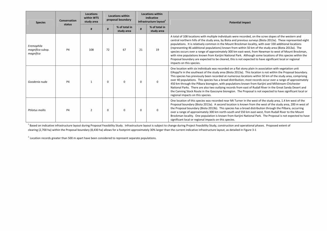
Species Conservation
status
Locations within WTS study area
Locations within proposal boundary
Locations within indicative
infrastructure layout1 Potential impact
# # % of total in study area
# % of total in study area
Eremophila magnifica subsp. magnifica
P4 108 72 67 21 19
A total of 108 locations with multiple individuals were recorded, on the scree slopes of the western and central northern hills of the study area, by Biota and previous surveys (Biota 2013a). These represented eight populations. It is relatively common in the Mount Brockman locality, with over 330 additional locations (representing 46 additional populations) known from within 50 km of the study area (Biota 2013a). The species occurs over a range of approximately 300 km east‐west, from Newman to west of Mount Brockman, with nine populations known from Karijini National Park. Although some locations of this species within the Proposal boundary are expected to be cleared, this is not expected to have significant local or regional impacts on this species.
Goodenia nuda P4 1 0 0 0 0
One location with six individuals was recorded on a flat stony plain in association with vegetation unit ElAsppTe in the southeast of the study area (Biota 2013a). This location is not within the Proposal boundary. This species has previously been recorded at numerous locations within 50 km of the study area, comprising over 40 populations. This species has a broad distribution; most records occur over a range of approximately 450 km through the Pilbara bioregion, with populations known from Karijini and Millstream‐Chichester National Parks. There are also two outlying records from east of Rudall River in the Great Sandy Desert and the Canning Stock Route in the Gascoyne bioregion. The Proposal is not expected to have significant local or regional impacts on this species.
Ptilotus mollis P4 2 0 0 0 0
One location of this species was recorded near Mt Turner in the west of the study area, 1.4 km west of the Proposal boundary (Biota 2013a). A second location is known from the west of the study area, 200 m west of the Proposal boundary (Biota 2013b). This species has a broad distribution through the Pilbara, occurring over a range of approximately 300 km north‐south and 550 km east‐west, from Rudall River to the Mount Brockman locality. One population is known from Karijini National Park. The Proposal is not expected to have significant local or regional impacts on this species.
1 Based on indicative infrastructure layout during Proposal Feasibility Study. Infrastructure layout is subject to change during Project Feasibility Study, construction and operational phases. Proposed extent of
clearing (2,700 ha) within the Proposal boundary (8,430 ha) allows for a footprint approximately 30% larger than the current indicative infrastructure layout, as detailed in Figure 3‐1
2 Location records greater than 500 m apart have been considered to represent separate populations.
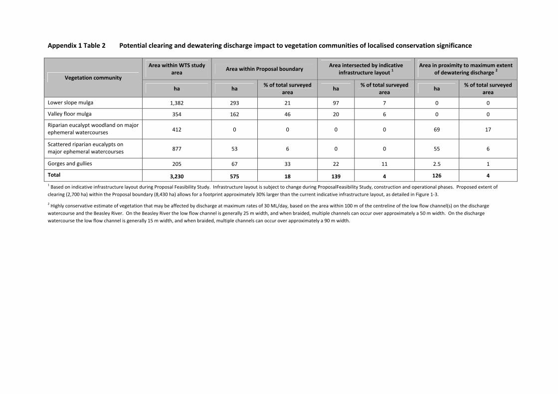
Appendix 1 Table 2 Potential clearing and dewatering discharge impact to vegetation communities of localised conservation significance
Vegetation community
Area within WTS study area
Area within Proposal boundary Area intersected by indicative
infrastructure layout 1 Area in proximity to maximum extent
of dewatering discharge 2
ha ha % of total surveyed
area ha
% of total surveyed area
ha % of total surveyed
area
Lower slope mulga 1,382 293 21 97 7 0 0
Valley floor mulga 354 162 46 20 6 0 0
Riparian eucalypt woodland on major ephemeral watercourses 412 0 0 0 0 69 17
Scattered riparian eucalypts on major ephemeral watercourses 877 53 6 0 0 55 6
Gorges and gullies 205 67 33 22 11 2.5 1
Total 3,230 575 18 139 4 126 4
1 Based on indicative infrastructure layout during Proposal Feasibility Study. Infrastructure layout is subject to change during ProposalFeasibility Study, construction and operational phases. Proposed extent of
clearing (2,700 ha) within the Proposal boundary (8,430 ha) allows for a footprint approximately 30% larger than the current indicative infrastructure layout, as detailed in Figure 1‐3.
2 Highly conservative estimate of vegetation that may be affected by discharge at maximum rates of 30 ML/day, based on the area within 100 m of the centreline of the low flow channel(s) on the discharge
watercourse and the Beasley River. On the Beasley River the low flow channel is generally 25 m width, and when braided, multiple channels can occur over approximately a 50 m width. On the discharge
watercourse the low flow channel is generally 15 m width, and when braided, multiple channels can occur over approximately a 90 m width.
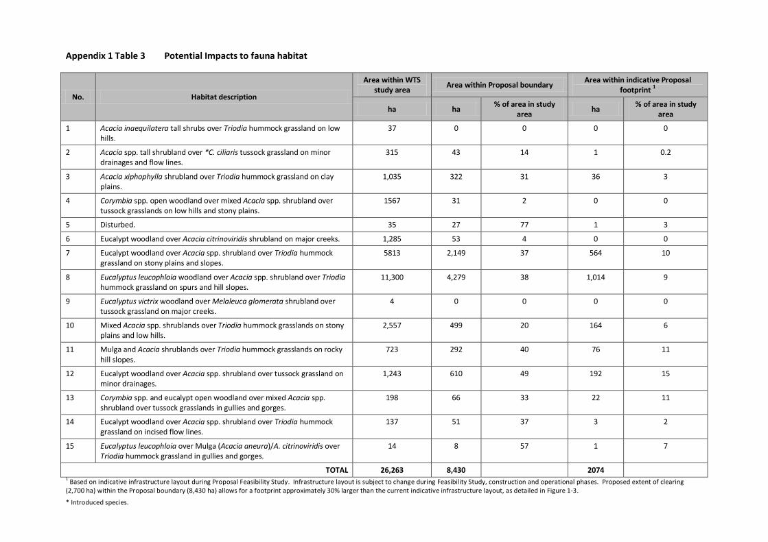
Appendix 1 Table 3 Potential Impacts to fauna habitat
No. Habitat description
Area within WTS study area Area within Proposal boundary Area within indicative Proposal
footprint 1
ha ha % of area in study area ha % of area in study
area
1 Acacia inaequilatera tall shrubs over Triodia hummock grassland on low hills.
37 0 0 0 0
2 Acacia spp. tall shrubland over *C. ciliaris tussock grassland on minor drainages and flow lines.
315 43 14 1 0.2
3 Acacia xiphophylla shrubland over Triodia hummock grassland on clay plains.
1,035 322 31 36 3
4 Corymbia spp. open woodland over mixed Acacia spp. shrubland over tussock grasslands on low hills and stony plains.
1567 31 2 0 0
5 Disturbed. 35 27 77 1 3
6 Eucalypt woodland over Acacia citrinoviridis shrubland on major creeks. 1,285 53 4 0 0
7 Eucalypt woodland over Acacia spp. shrubland over Triodia hummock grassland on stony plains and slopes.
5813 2,149 37 564 10
8 Eucalyptus leucophloia woodland over Acacia spp. shrubland over Triodia hummock grassland on spurs and hill slopes.
11,300 4,279 38 1,014 9
9 Eucalyptus victrix woodland over Melaleuca glomerata shrubland over tussock grassland on major creeks.
4 0 0 0 0
10 Mixed Acacia spp. shrublands over Triodia hummock grasslands on stony plains and low hills.
2,557 499 20 164 6
11 Mulga and Acacia shrublands over Triodia hummock grasslands on rocky hill slopes.
723 292 40 76 11
12 Eucalypt woodland over Acacia spp. shrubland over tussock grassland on minor drainages.
1,243 610 49 192 15
13 Corymbia spp. and eucalypt open woodland over mixed Acacia spp. shrubland over tussock grasslands in gullies and gorges.
198 66 33 22 11
14 Eucalypt woodland over Acacia spp. shrubland over Triodia hummock grassland on incised flow lines.
137 51 37 3 2
15 Eucalyptus leucophloia over Mulga (Acacia aneura)/A. citrinoviridis over Triodia hummock grassland in gullies and gorges.
14 8 57 1 7
TOTAL 26,263 8,430 2074 1 Based on indicative infrastructure layout during Proposal Feasibility Study. Infrastructure layout is subject to change during Feasibility Study, construction and operational phases. Proposed extent of clearing (2,700 ha) within the Proposal boundary (8,430 ha) allows for a footprint approximately 30% larger than the current indicative infrastructure layout, as detailed in Figure 1-3.
* Introduced species.
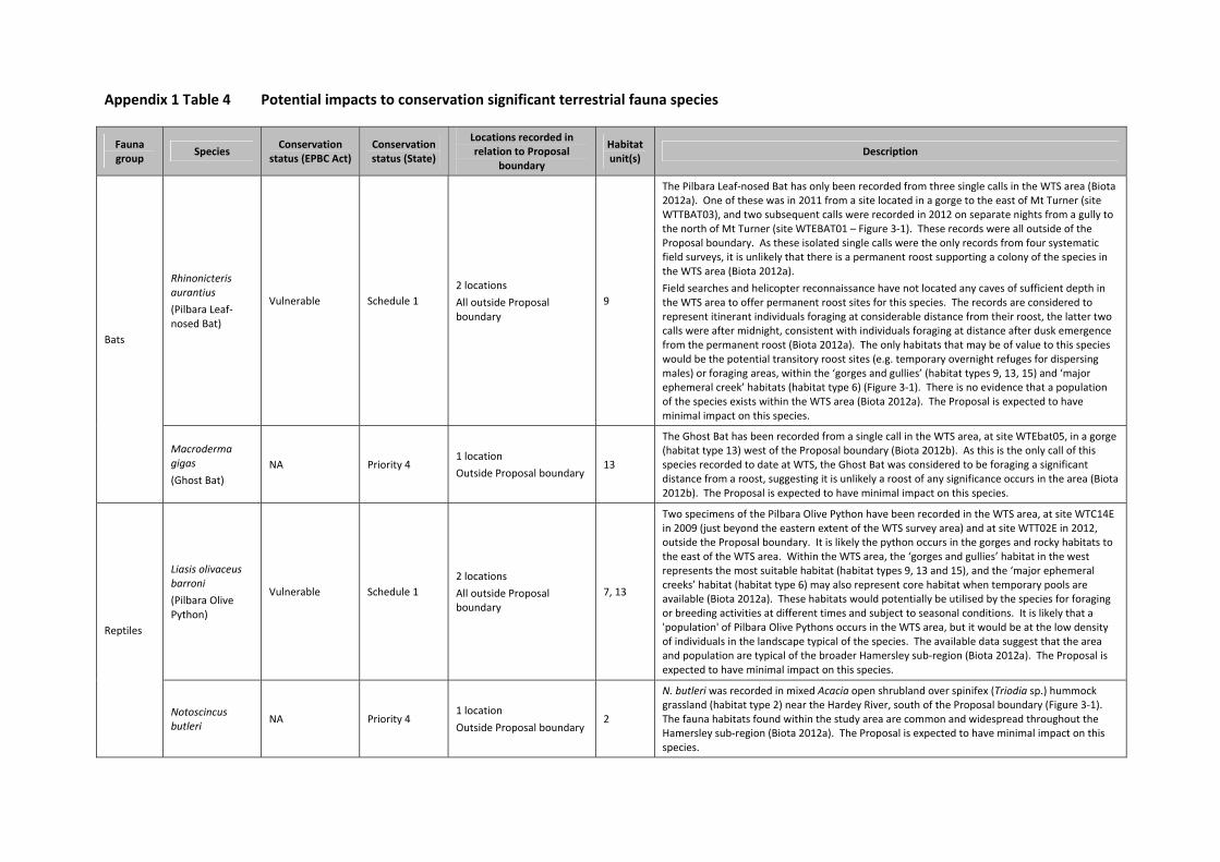
Appendix 1 Table 4 Potential impacts to conservation significant terrestrial fauna species
Fauna group
Species Conservation
status (EPBC Act) Conservation status (State)
Locations recorded in relation to Proposal
boundary
Habitat unit(s)
Description
Bats
Rhinonicteris aurantius
(Pilbara Leaf‐nosed Bat)
Vulnerable Schedule 1
2 locations
All outside Proposal boundary
9
The Pilbara Leaf‐nosed Bat has only been recorded from three single calls in the WTS area (Biota 2012a). One of these was in 2011 from a site located in a gorge to the east of Mt Turner (site WTTBAT03), and two subsequent calls were recorded in 2012 on separate nights from a gully to the north of Mt Turner (site WTEBAT01 – Figure 3‐1). These records were all outside of the Proposal boundary. As these isolated single calls were the only records from four systematic field surveys, it is unlikely that there is a permanent roost supporting a colony of the species in the WTS area (Biota 2012a).
Field searches and helicopter reconnaissance have not located any caves of sufficient depth in the WTS area to offer permanent roost sites for this species. The records are considered to represent itinerant individuals foraging at considerable distance from their roost, the latter two calls were after midnight, consistent with individuals foraging at distance after dusk emergence from the permanent roost (Biota 2012a). The only habitats that may be of value to this species would be the potential transitory roost sites (e.g. temporary overnight refuges for dispersing males) or foraging areas, within the ‘gorges and gullies’ (habitat types 9, 13, 15) and ‘major ephemeral creek’ habitats (habitat type 6) (Figure 3‐1). There is no evidence that a population of the species exists within the WTS area (Biota 2012a). The Proposal is expected to have minimal impact on this species.
Macroderma gigas
(Ghost Bat)
NA Priority 4 1 location
Outside Proposal boundary 13
The Ghost Bat has been recorded from a single call in the WTS area, at site WTEbat05, in a gorge (habitat type 13) west of the Proposal boundary (Biota 2012b). As this is the only call of this species recorded to date at WTS, the Ghost Bat was considered to be foraging a significant distance from a roost, suggesting it is unlikely a roost of any significance occurs in the area (Biota 2012b). The Proposal is expected to have minimal impact on this species.
Reptiles
Liasis olivaceus barroni
(Pilbara Olive Python)
Vulnerable Schedule 1
2 locations
All outside Proposal boundary
7, 13
Two specimens of the Pilbara Olive Python have been recorded in the WTS area, at site WTC14E in 2009 (just beyond the eastern extent of the WTS survey area) and at site WTT02E in 2012, outside the Proposal boundary. It is likely the python occurs in the gorges and rocky habitats to the east of the WTS area. Within the WTS area, the ‘gorges and gullies’ habitat in the west represents the most suitable habitat (habitat types 9, 13 and 15), and the ‘major ephemeral creeks’ habitat (habitat type 6) may also represent core habitat when temporary pools are available (Biota 2012a). These habitats would potentially be utilised by the species for foraging or breeding activities at different times and subject to seasonal conditions. It is likely that a 'population' of Pilbara Olive Pythons occurs in the WTS area, but it would be at the low density of individuals in the landscape typical of the species. The available data suggest that the area and population are typical of the broader Hamersley sub‐region (Biota 2012a). The Proposal is expected to have minimal impact on this species.
Notoscincus butleri
NA Priority 4 1 location
Outside Proposal boundary 2
N. butleri was recorded in mixed Acacia open shrubland over spinifex (Triodia sp.) hummock grassland (habitat type 2) near the Hardey River, south of the Proposal boundary (Figure 3‐1). The fauna habitats found within the study area are common and widespread throughout the Hamersley sub‐region (Biota 2012a). The Proposal is expected to have minimal impact on this species.
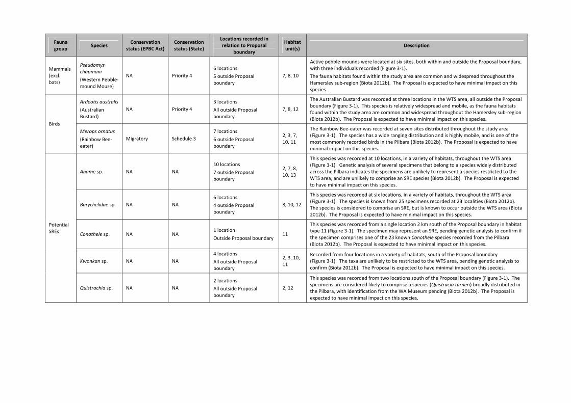
Fauna group
Species Conservation
status (EPBC Act) Conservation status (State)
Locations recorded in relation to Proposal
boundary
Habitat unit(s)
Description
Mammals (excl. bats)
Pseudomys chapmani
(Western Pebble‐mound Mouse)
NA Priority 4
6 locations
5 outside Proposal boundary
7, 8, 10
Active pebble‐mounds were located at six sites, both within and outside the Proposal boundary, with three individuals recorded (Figure 3‐1).
The fauna habitats found within the study area are common and widespread throughout the Hamersley sub‐region (Biota 2012b). The Proposal is expected to have minimal impact on this species.
Birds
Ardeotis australis
(Australian Bustard)
NA Priority 4
3 locations
All outside Proposal boundary
7, 8, 12
The Australian Bustard was recorded at three locations in the WTS area, all outside the Proposal boundary (Figure 3‐1). This species is relatively widespread and mobile, as the fauna habitats found within the study area are common and widespread throughout the Hamersley sub‐region (Biota 2012b). The Proposal is expected to have minimal impact on this species.
Merops ornatus
(Rainbow Bee‐eater)
Migratory Schedule 3
7 locations
6 outside Proposal boundary
2, 3, 7, 10, 11
The Rainbow Bee‐eater was recorded at seven sites distributed throughout the study area (Figure 3‐1). The species has a wide ranging distribution and is highly mobile, and is one of the most commonly recorded birds in the Pilbara (Biota 2012b). The Proposal is expected to have minimal impact on this species.
Potential SREs
Aname sp. NA NA
10 locations
7 outside Proposal boundary
2, 7, 8, 10, 13
This species was recorded at 10 locations, in a variety of habitats, throughout the WTS area (Figure 3‐1). Genetic analysis of several specimens that belong to a species widely distributed across the Pilbara indicates the specimens are unlikely to represent a species restricted to the WTS area, and are unlikely to comprise an SRE species (Biota 2012b). The Proposal is expected to have minimal impact on this species.
Barychelidae sp. NA NA
6 locations
4 outside Proposal boundary
8, 10, 12
This species was recorded at six locations, in a variety of habitats, throughout the WTS area (Figure 3‐1). The species is known from 25 specimens recorded at 23 localities (Biota 2012b). The species is considered to comprise an SRE, but is known to occur outside the WTS area (Biota 2012b). The Proposal is expected to have minimal impact on this species.
Conothele sp. NA NA 1 location
Outside Proposal boundary 11
This species was recorded from a single location 2 km south of the Proposal boundary in habitat type 11 (Figure 3‐1). The specimen may represent an SRE, pending genetic analysis to confirm if the specimen comprises one of the 23 known Conothele species recorded from the Pilbara (Biota 2012b). The Proposal is expected to have minimal impact on this species.
Kwonkan sp. NA NA
4 locations
All outside Proposal boundary
2, 3, 10, 11
Recorded from four locations in a variety of habitats, south of the Proposal boundary (Figure 3‐1). The taxa are unlikely to be restricted to the WTS area, pending genetic analysis to confirm (Biota 2012b). The Proposal is expected to have minimal impact on this species.
Quistrachia sp. NA NA
2 locations
All outside Proposal boundary
2, 12
This species was recorded from two locations south of the Proposal boundary (Figure 3‐1). The specimens are considered likely to comprise a species (Quistracia turneri) broadly distributed in the Pilbara, with identification from the WA Museum pending (Biota 2012b). The Proposal is expected to have minimal impact on this species.
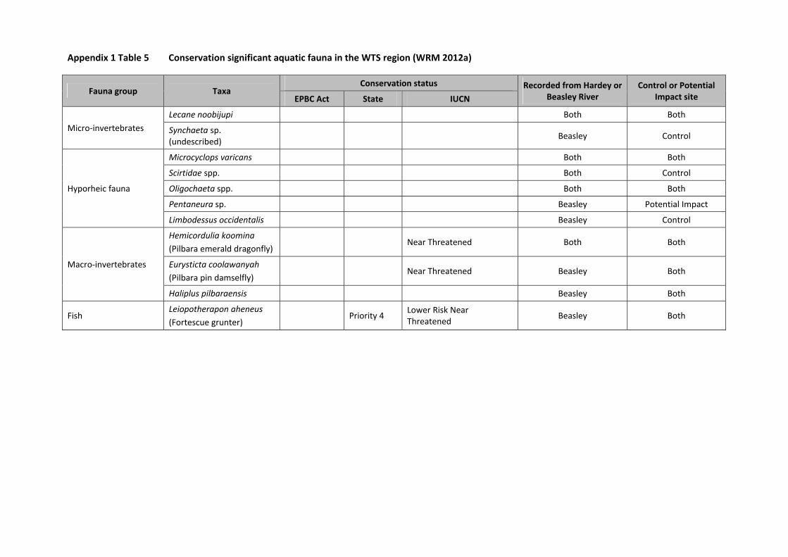
Appendix 1 Table 5 Conservation significant aquatic fauna in the WTS region (WRM 2012a)
Fauna group Taxa Conservation status Recorded from Hardey or
Beasley River Control or Potential
Impact site EPBC Act State IUCN
Micro‐invertebrates
Lecane noobijupi Both Both
Synchaeta sp. (undescribed)
Beasley Control
Hyporheic fauna
Microcyclops varicans Both Both
Scirtidae spp. Both Control
Oligochaeta spp. Both Both
Pentaneura sp. Beasley Potential Impact
Limbodessus occidentalis Beasley Control
Macro‐invertebrates
Hemicordulia koomina
(Pilbara emerald dragonfly) Near Threatened Both Both
Eurysticta coolawanyah
(Pilbara pin damselfly) Near Threatened Beasley Both
Haliplus pilbaraensis Beasley Both
Fish Leiopotherapon aheneus
(Fortescue grunter) Priority 4
Lower Risk Near Threatened
Beasley Both

Western Turner Syncline Stage 2 – B1 and S17 Deposits API: Environmental Review Document
Page 89
List of Appendices – Supporting Document
Appendix 2 A Vegetation and Flora Survey of the West Turner Section 10 Area and Infrastructure Corridor (Biota 2007).
Appendix 3 West Turner Syncline Section 10 Development Two‐Phase Fauna Survey (Biota 2009a).
Appendix 4 A Two‐Phase Fauna Survey of the West Turner Syncline Area, (Biota 2009b).
Appendix 5 West Turner Targeted Fauna Survey (Biota 2011a).
Appendix 6 West Turner Syncline Section 10 Expanded Vegetation and Flora Survey Report (Biota 2011b).
Appendix 7 West Turner Syncline Phase 2 Vegetation and Flora Report (Biota 2013a).
Appendix 8 West Turner Syncline NES Species Assessment (Biota 2012a).
Appendix 9 West Turner Syncline Fauna Survey Summary Report (Biota 2012b).
Appendix 10 West Turner Syncline Stage 2 – Phase 1 Survey and Targeted Vegetation Survey (Biota 2013b).
Appendix 11 West Turner Syncline Stage 2 B1 and Section 17 Deposits Subterranean Fauna Survey (Biota 2012c).
Appendix 12 Western Turner Syncline Stage 2 Visual Impact Assessment (Ecoscape 2012).
Appendix 13 Predicted Dust Levels from Western Turner Syncline Stage 2 (B1 and S17) Iron Ore Project (Environmental Alliances 2012).
Appendix 14 Western Turner Syncline Stage 2 Project Ecological Risk Assessment (Equinox Environmental 2012).
Appendix 15 WTS2 B1 Water Quality Assessment (KCB 2012b).
Appendix 16 Potential Impacts of Dewatering and Discharge to Duck Creek and Caves Creek, Greater Nammuldi (Rio Tinto 2011).
Appendix 17 Baseline Hydrology Assessment for Local Creek Discharge from WTS B1 (Rio Tinto 2012a).
Appendix 18 Western Turner Syncline B1 – Feasibility Study Groundwater Modelling: Dewatering and Closure (Rio Tinto 2013a).
Appendix 19 WTS Phase II Surface Water Management, unpublished report prepared by Rio Tinto (Rio Tinto 2012c).
Appendix 20 Western Turner Syncline B1 – Feasibility Studies Groundwater Modelling: Dewatering and Closure (Rio Tinto 2012d).
Appendix 21 Surface hydrology in the vicinity of the WTS2 infrastructure corridor between WTS B1 and S10; assessment and modelling of natural surface flows (Rio Tinto 2012e).
Appendix 22 Western Turner Syncline B1 and S17 AMD Risk Assessment (Rio Tinto 2012f).
Appendix 23 Western Turner Syncline (Stage 2) Closure Plan (Rio Tinto 2012g).
Appendix 24 Environmental Noise Assessment of Western Turner Syncline Stage II Project (SVT 2012).
Appendix 25 West Turner Syncline Stage 2 ‐ Potential impacts of mining operations on overland flow dependent vegetation ‐ Preliminary assessment (UWA 2012a).
Appendix 26 West Turner Syncline Stage 2 ‐ Potential impacts of mining operations on groundwater dependent vegetation ‐ Preliminary assessment (UWA 2012b).
Appendix 27 Western Turner Syncline Project, wet & dry 2011 sampling, final report (WRM 2012a).
Appendix 28 WTS2 – groundwater quality updated data (WRM 2012b).
Appendix 29 WTS Stage 2 FS – Water balance & strategy update (Rio Tinto 2013b).
Appendix 30 Checklist for documents submitted for EIA on marine and terrestrial biodiversity.
Appendix 31 EPA prepared scoping guideline.
Recommended