Embed Size (px)
Citation preview

ENAV - Roma
AIP - Italia
AIRAC effective date
1 LIMP PARMAIndicatore di localitàLocation indicator
Nome dell’ AeroportoAerodrome name
2 DATI AMMINISTRATIVI E GEOGRAFICI DELL’AEROPORTO AERODROME GEOGRAPHICAL AND ADMINISTRATIVE DATA
1 Coordinate ARP ARP coordinates44°49'20''N 010°17'43''E 44°49'20''N 010°17'43''E
2 Direzione e distanza dalla città Direction and distance from city1.35 NM NW di Parma 1.35 NM NW Parma
3 Elevazione/Temperatura di riferimento Elevation/Reference temperature161 FT / 29.2 °C 161 FT / 29.2 °C
4 Ondulazione del geoide Geoid undulation126.3 FT 126.3 FT
5 Variazione magnetica/Variazione annuale Magnetic variation/Annual change1° E (2005.0) / 6'E 1° E (2005.0) / 6'E
6 Autorità amministrativa aeroportuale Aerodrome administration authorityENAC - DA Emilia-RomagnaAeroporto "Guglielmo Marconi"Via Triumvirato, 8440132 BolognaTel: +39 051 6479690 Fax: +39 051 6486909E-mail: [email protected] di ParmaTel +39 0521 992986/951518Fax +39 0521 992986
ENAC - DA Emilia-RomagnaAeroporto "Guglielmo Marconi"Via Triumvirato, 8440132 BolognaTel: +39 051 6479690 Fax: +39 051 6486909E-mail: [email protected] officeTel +39 0521 992986/951518Fax +39 0521 992986
Esercente Aerodrome operatorSo.Ge.A.P. S.p.A.Via Licinio Ferretti n.50/a43126 ParmaTel +39 0521 951516; Fax +39 0521 992028 (direzione)e-mail: [email protected]
So.Ge.A.P. S.p.A.Via Licinio Ferretti n.50/a43126 ParmaTel +39 0521 951516; Fax +39 0521 992028 (management)e-mail: [email protected]
Autorità ATS ATS authorityENAV S.p.A.Centro Aeroportuale ParmaTel: +39 0521 919003; fax: +39 0521 919009e-mail: [email protected]
ENAV S.p.A.Centro Aeroportuale ParmaTel: +39 0521 919003; fax: +39 0521 919009e-mail: [email protected]
7 Tipo di traffico consentito (IFR/VFR) Type of traffic permitted (IFR/VFR)IFR/VFR IFR/VFR
8 Note Remarks1) UFFICIO OPERATIVO So.Ge.A.P. +39 0521 951512
FAX +39 0521 9515302) AREA PASSEGGERI +39 0521 951551 FAX +39 0521 992028
1) OPERATION OFFICE So.Ge.A.P. +39 0521 951512FAX +39 0521 951530
2) LAND SIDE AREA +39 0521 951551 FAX +39 0521 992028
3 ORARIO DI SERVIZIO OPERATIONAL HOURS
1 Amministrazione aeroportuale Aerodrome Administration0530-2230 (0430-2130) 0530-2230 (0430-2130)
2 Dogana e immigrazione Customs and immigrationO/R con 24H di preavviso tramite fax So.Ge.A.P. +39 0521 951530 O/R 24H PN by fax to So.Ge.A.P. +39 0521 951530
3 Servizio sanitario Health and sanitationNIL NIL
4 AIS Briefing Office AIS Briefing OfficeH24 ARO CBO MILANO H24 ARO CBO MILANO
5 ARO AROH24 ARO CBO MILANO H24 ARO CBO MILANO
6 METEO Briefing Office METEO Briefing OfficeH24 ARO CBO MILANO H24 ARO CBO MILANO
7 ATS ATS0600-2200 (0500-2100) 0600-2200 (0500-2100)
8 Rifornimento Fuelling0500-2130 (0400-2030)Operatore AirBP tel +39 3346728225Il rifornimento per i voli non di linea deve essere richiesto almeno 2HR PN chiamando i numeri: +39 0521 982986 o 3346728225
0500-2130 (0400-2030)Operator AirBP ph +39 3346728225Fuel for non scheduled flights has to be requested at least 2 HR PNby phone at: +39 0521 982986 or +39 3346728225
9 Handling Handling0530-2230 (0430-2130) 0530-2230 (0430-2130)
10 Servizi di sicurezza SecurityPrevio coordinamento con So.Ge.A.P 0530-2230 (0430-2130)1 HR PN
Upon coordination with So.Ge.A.P. 0530-2230 (0430-2130)1 HR PN
11 De-icing De-icing0530-2230 (0430-2130)Pista e apron: fluido anti-icing utilizzato SAFEGRIP SR. Capacità:40.000 lt. Aeromobili: disponibile O/R tipo Killfrost TYPE II ABC.Capacità: 30.000 lt
0530-2230 (0430-2130)Runway and apron: anti icing used SAFEGRIP SR. Capacity: 40.000lt. Aircraft: available O/R Killfrost TYPE II ABC. Capacity 30.000 lt
12 Note Remarks1) Amministrazione aeroportuale: 1) Aerodrome administration:
a) I vettori che volessero operare oltre questi orari dovrannofarne richiesta almeno 3 giorni prima a So.Ge.A.P.
a) Operators wanting to operate flights outside the normalopening hours must request permission with at least 3days notice before ETA
b) I voli sanitari dovranno coordinare entro 30' dallachiusura del servizio
b) Ambulance flights must be coordinated at least 30' beforeairport clousure
AD 2 LIMP 1-1
17 AUG 2017 (A7/17)
ENAV - Roma
AIP - Italia
AIRAC effective date
2) Handling: 2) Handling:a) So.Ge.A.P. tel +39 0521 951512 fax +39 0521 951530
0530-2230 (0430-2130)a) So.Ge.A.P. ph +39 0521 951512 fax +39 0521 951530
0530-2230 (0430-2130)b) Parcheggio e servizi handling saranno garantiti ai soli
operatori in possesso di PPR almeno 24 ore prima dellostimato di arrivo. Tale richiesta dovrà essere presentatanelle seguenti modalità:- via e-mail [email protected] Fax +39 0521 951530
b) Parking and handling services will be granted only tooperators owing a PPR at least 24 hours before theestimated time of arrival. The above mentioned requestshall be forwarded as follows:- via e-mail [email protected] Fax +39 0521 951530
c) Per chi non fosse in possesso di PPR, stand e handlingsaranno a discrezione di So.Ge.A.P. che valuterà in basealla programmazione giornaliera
c) To all operators not owing a PPR, stand and handlingservices will be granted on So.Ge.A.P. discretion, basedon its daily program
d) Handling radio: PARMA OPERATION CH 131.430 Mhz d) Handling radio: PARMA OPERATION CH 131.430 Mhz3) ARO CBO MILANO: vedi GEN 3.1 3) ARO CBO MILANO: vedi GEN 3.1
4 SERVIZI DI SUPPORTO ED ATTREZZATURE HANDLING SERVICES AND FACILITIES
1 Attrezzatura di carico e scarico merci Cargo-handling facilitiesNastri trasportatori - fork lift Conveyor belts - fork lift
2 Tipi di carburante/Olio Fuel/Oil typesJET A1 / NIL JET A1 / NIL
3 Capacità di rifornimento Fuelling capacity90.000 lt/NIL 90.000 lt/NIL
4 Sistema de-icing De-icing facilities1 MEZZO TEMPEST AIRCRAFT DE-ICER 1 TEMPEST AIRCRAFT DE-ICER
5 Hangar per aeromobili in transito Hangar space for visiting aircraftNIL NIL
6 Servizio riparazioni per aeromobili in transito Repair facilities for visiting aircraftNIL NIL
7 Note Remarks1) GPU 28/115, scale, ACU, ASU, ambulift, trattorini 1) GPU 28/115, stairs, ACU, ASU, ambulift, tractors
5 SERVIZI PER I PASSEGGERI PASSENGER FACILITIES
1 Alberghi HotelsIn città e nei pressi dell'aeroporto Both in town and close to the airport
2 Ristoranti Restaurants Sì Yes
3 Trasporti TransportationTaxi - bus - autonoleggio - (noleggio con conducente) Taxi - bus - car rental - (limousine service)
4 Servizio medico Medical facilitiesPresidio Croce Rossa Italiana 0530-2230 (0430-2130) per interventodi primo soccorso. Personale paramedico ospedaliero nella città diParma, a 3 km.
First aid treatment (Italian Red Cross) 0530-2230 (0430-2130).Paramedical staff hospital in Parma at 3 km from the airport.
5 Banca e ufficio postale Bank and Post officeSportello Bancomat Cash dispenser
6 Ufficio turistico Tourist officeNIL NIL
7 Note RemarksNIL NIL
6 SERVIZI ANTINCENDIO E DI SOCCORSO RESCUE AND FIRE FIGHTING SERVICES
1 Categoria servizio antincendio aeroportuale Aerodrome category for fire fightingCAT 7 ICAO CAT 7 ICAO
2 Equipaggiamento per il soccorso Rescue equipmentCoordinato da So.Ge.A.P. S.p.A. Coordinated by So.Ge.A.P. S.p.A.
3 Rimozione aeromobili in difficoltà Capability for removal of disabled aircraftCoordinato da So.Ge.A.P. S.p.A. Coordinated by So.Ge.A.P. S.p.A.
4 Note RemarksNIL NIL
7 DISPONIBILITA’ STAGIONALE E SISTEMI DI PULITURAPISTE
SEASONAL AVAILABILITY AND CLEARING
1 Equipaggiamenti di pulitura Types of clearing equipmentSpazzatrice aeroportuale, attrezzatura sgombero neve e antighiaccio Airport sweeper, snow removal equipment
2 Priorità Clearance prioritiesPista, TWY, piazzali Runway, TWY, apron
3 Note Remarks1) Il coefficiente di attrito della pista è misurato utilizzando il
rilevatore di aderenza tipo Griptester MK11) The surface friction measure on the RWY is done using the
friction system Griptester MK1
AD 2 LIMP 1-2
17 AUG 2017 (A7/17)
ENAV - Roma
AIP - Italia
AIRAC effective date
8 DATI RELATIVI AI PIAZZALI, ALLE VIE DI RULLAGGIO EDALLE PIAZZOLE PROVA
APRONS, TAXIWAYS AND CHECK LOCATIONS DATA
1 Superficie e resistenza dell’area di stazionamento Apron surface and strengthApron 100Superficie: ASPH 15674 m²Resistenza: PCN 46/F/A/W/TApron 300Superficie: NIL 7462 m²Resistenza: PCN 27/F/A/W/T
Apron 100Surface: ASPH 15674 m²Strength: PCN 46/F/A/W/TApron 300Surface: NIL 7462 m²Strength: PCN 27/F/A/W/T
2 Larghezza, superficie e resistenza delle TWY TWY width, surface and strengthALarghezza: 11 MSuperficie: NILResistenza: PCN 27/F/B/W/TBLarghezza: 18 MSuperficie: NILResistenza: PCN 52/F/B/W/TCLarghezza: 18 MSuperficie: NILResistenza: PCN 45/F/B/W/TDLarghezza: 10 MSuperficie: NILResistenza: PCN 43/F/B/W/T
AWidth: 11 MSurface: NILStrength: PCN 27/F/B/W/TBWidth: 18 MSurface: NILStrength: PCN 52/F/B/W/TCWidth: 18 MSurface: NILStrength: PCN 45/F/B/W/TDWidth: 10 MSurface: NILStrength: PCN 43/F/B/W/T
3 Localizzazione/Elevazione ACL ACL location/ElevationNIL / NIL NIL / NIL
4 Punto di controllo VOR/INS VOR/INS checkpointsNIL / NIL NIL / NIL
5 Note RemarksNIL NIL
9 GUIDA AI MOVIMENTI A TERRA E SISTEMI DI CONTROLLO ESEGNALAZIONE
SURFACE MOVEMENT GUIDANCE AND CONTROL SYSTEM ANDMARKINGS
1 Segnale di identificazione stand aeromobili, linee guida perTWY e sistemi di guida per parcheggio a vista negli standdegli aeromobili
Use of aircraft stand identification sign, TWY guide lines andvisual docking/parking guidance system of aircraft stands
NIL NIL2 Illuminazione e segnaletica per RWY e TWY RWY and TWY markings and lights
Vedi carta AD in vigore See AD chart in force3 Barre d’arresto Stop bars
Vedi carta AD in vigore See AD chart in force4 Note Remarks
NIL NIL
10 OSTACOLI AEROPORTUALI AERODROME OBSTACLES
Nelle aree di avvicinamento e decolloIn approach and take off areas
Nell’area di circuitazione e all’interno dell’aerodromo
In circling area and at aerodrome
NoteRemarks
1 2 3RWY e Area interessata
RWY and Area affected
Tipo di ostacoloElevazione
Segnaletica e LuciObstacle type
ElevationMarkings and Lights
CoordinateCoordinates
Tipo di ostacoloElevazione
Segnaletica e LuciObstacle type
ElevationMarking and Lights
CoordinateCoordinates
a b c a bVedi AOC in vigore - See AOC in force
11 INFORMAZIONI METEOROLOGICHE METEOROLOGICAL INFORMATION
1 Ufficio METEO associato Associated MET OfficeUPM MILANO UPM MILANO
2 Orario di servizio Hours of serviceH24 H24
3 Ufficio responsabile preparazione TAF/Periodo di validità Office responsible for TAF preparation/Period of validityUPM MILANO / 24H UPM MILANO / 24H
4 Tipo di previsione per l’atterraggio/Intervallo di emissione Type of landing forecast/Interval of issuanceNIL / NIL NIL / NIL
5 Briefing e consultazione fornita Briefing and consultation providedBriefing: ARO CBO MILANO, telefonoConsultazione: UPM MILANO, telefono
Briefing: ARO CBO MILANO, telephoneConsultation: UPM MILANO, telephone
6 Documentazione di volo/Lingua usata Flight documentation/Language usedCarte - testi in linguaggio abbreviatoIT / EN
Charts - abbreviated plain language textIT / EN
7 Carte e documentazione disponibili per consultazione Charts and other information available for briefing orconsultation
P, W, SWL P, W, SWL
AD 2 LIMP 1-3
12 OCT 2017 (A9/17)
ENAV - Roma
AIP - Italia
AIRAC effective date
8 Mezzi aggiuntivi disponibili per l’informazione Supplementary equipment available for providinginformation
Fax Fax9 Enti ATS destinatari delle informazioni ATS units provided with information
Parma TWR, Parma APP Parma TWR, Parma APP10 Informazioni climatologiche e informazioni supplementari Climatological information and additional information
1) ARO CBO MILANO: vedi GEN 3.1 1) ARO CBO MILANO: see GEN 3.12) UPM MILANO: vedi Gen 3.5 2) UPM MILANO: see GEN 3.53) Nubi operativamente significative: sono ritenute
operativamente significative le nubi con altezza della base al disotto di 8500ft e cumulonembi o cumuli torreggianti con basedi qualsiasi altezza
3) Clouds of operational significance: clouds with base heightbelow 8500ft and cumulonimbus or towering cumulus with anybase height are considered of operational significance
12 CARATTERISTICHE FISICHE DELLE PISTE RUNWAY PHYSICAL CHARACTERISTICS
DesignazioneNR RWY
Designation
QFU Dimensioni RWYDimension of RWY
(M)
Resistenza e superficie di RWY
Strength and surface of RWY
Coordinate THRTHR coordinates
---Coordinate RWY ENDRWY END Coordinates
---Ondulazione Geoide THR
THR Geoid Undulation
THR ELEV, MAX TDZ ELEVdella RWY per APCH di
precisioneTHR ELEV, MAX TDZ ELEVof precision APCH RWY
1 2 3 4 5 6
02 016° 2124 x 45 PCN 46/F/B/W/TASPH
44°49'10.18''N010°17'38.16''E
-----------------------------44°50'09.20''N010°18'04.13''E
-----------------------------126.3 FT
158 FT / NIL
20 196° 2124 x 45 PCN 46/F/B/W/TASPH
44°50'03.54''N010°18'01.63''E
-----------------------------44°49'03.54''N010°17'35.24''E
-----------------------------126.1 FT
146.6 FT / 147 FT
DesignazioneNR RWY
Designation
Pendenza diRWY-SWY
Slope
Dimensioni SWYSWY dimension
(M)
Dimensioni CWYCWY dimension
(M)
Dimensioni stripstrip dimension
(M)
Dimensioni RESARESA dimension
(M)1 7 8 9 10 11
02
Longitudinale / Longitudinal:
NILTrasversale / Trasversal:
1,3%
NIL 60 x 150 2244 x 300 138 x 150
20
Longitudinale / Longitudinal:
NILTrasversale / Trasversal:
1,3%
NIL 84 x 150 2244 x 300 90 x 150
DesignazioneNR RWY
Designation
OFZObstacle free zone (OFZ)
NoteRemarks
1 12 13
02 NIL1) DTHR 215 m
2) Nei primi 280 m la larghezza della STRIP di sicurezza è ridotta a 220 m/First 280 m of safetySTRIP width reduced to 220 m
20 Non applicableNot applicable 1) DTHR 183 m
13 DISTANZE DICHIARATE DECLARED DISTANCES
Designazione RWY RWY designator
TORA(M)
TODA(M)
ASDA(M)
LDA(M)
1 2 3 4 502 2124 2184 2124 190920 2124 2208 2124 1941
14 LUCI DI AVVICINAMENTO E LUCI PISTA APPROACH AND RUNWAY LIGHTING
RWYID
AVVICINAMENTOAPPROACH
THR VASIS PAPI MEHT(M)
TDZ
TipoType
LunghezzaLength
(M)
IntensitàIntensity
ColoreColour
LunghezzaLength
(M)
1 2.1 2.2 2.3 3 4.1 4.2 4.3 5
02 NIL NIL NIL Wing barsG NIL
3°wing bars
entrambi i latiwing barsboth sides
15.5 NIL
AD 2 LIMP 1-4
12 OCT 2017 (A9/17)

ENAV - Roma
AIP - Italia
AIRAC effective date
20 CAT I 900 VRB THRG NIL
3°wing bars
entrambi i latiwing barsboth sides
16.5 900
RWYID
ASSE CENTRALE PISTARCL
BORDO PISTARWY EDGE
LunghezzaLength
(M)
SpaziaturaSpacing
(M)
ColoreColour
IntensitàIntensity
LunghezzaLength
(M)
SpaziaturaSpacing
(M)
ColoreColour
IntensitàIntensity
1 6.1 6.2 6.3 6.4 7.1 7.2 7.3 7.4
021222600300
151515
WW/R
R
VRBVRBVRB
2141308600
606060
RWY
NILNILNIL
201040600300
151515
WW/R
R
VRBVRBVRB
1821340600
606060
RWY
NILNILNIL
RWYID
FINE PISTARWY END
SWY RTIL CGL NoteRemarks
ColoreColour
LunghezzaLength
(M)
ColoreColour
1 8 9.1 9.2 10 11 12
02 R NIL NIL NIL NIL
1) PAPI 02:superficieprotezione ostacolinon strumentale/obstacle protectionsurface notinstrumental
2) WARNING: iseguenti ostacoliinteressano lasuperficieprotezione ostacoli/obstacles affectingobstacle protectionsurface:alberi/trees620m prima/beforeRWY THR 02, 70ma destra/right sideRCL e/and antenna317m prima/beforeRWY THR 02, 100ma sinistra/left sideRCL. Ostacoli nonprovvisti disegnaletica ICAO/obstacles notprovided with ICAOsignals
20 R NIL NIL NIL NIL1) RTZL:spaziatura /spacing 30m
15 ILLUMINAZIONE AGGIUNTIVA, ALIMENTAZIONE SECONDARIA OTHER LIGHTING, SECONDARY POWER SUPPLY
1 Localizzazione ABN/IBN, caratteristiche e orari ABN/IBN location, characteristics and hours of operationCoordinate ABN: 44°49'09''N 010°17'30''ECaratteristiche: rotante luce bianco-verde alternataOrario: O/R
ABN Coordinates: 44°49'09''N 010°17'30''ECharacteristics: revolving white-green alternating lightHours: O/R
2 Localizzazione LDI e luciLocalizzazione anemometro e luci
LDI location and lightsAnemometer location and lights
LDI: NILAnemometri:1) 1250 m dopo THR RWY 20, 135 m lato destro RCL2) 540 m dopo THR RWY 20, 85 m lato destro RCL
LDI: NILAnemometers:1) 1250 m after THR RWY 20, 135 m right side RCL2) 540 m after THR RWY 20, 85 m right side RCL
3 Illuminazione bordo e asse centrale TWY TWY edge and centre line lightingA, B, D: asse centrale e bordiC: asse centrale e catarifrangenti sui bordi
A, B, D: centerline and edgesC: centerline and retroreflective markers on the edges
4 Alimentatore secondario/Tempo di intervento Secondary power supply/Switch over timeSì/max 1 secondo per luci di asse, bordo pista, soglie e fine pista +CALVERT + PAPI + TDZ + stop bar
Yes/max 1 second for RWY centerline, edge, thresholds and RWYend lights + CALVERT + PAPI + TDZ + stop bars
5 Note RemarksNIL NIL
RWYID
AVVICINAMENTOAPPROACH
THR VASIS PAPI MEHT(M)
TDZ
TipoType
LunghezzaLength
(M)
IntensitàIntensity
ColoreColour
LunghezzaLength
(M)
1 2.1 2.2 2.3 3 4.1 4.2 4.3 5
AD 2 LIMP 1-5
17 AUG 2017 (A7/17)

ENAV - Roma
AIP - Italia
AIRAC effective date
16 AREA DI ATTERRAGGIO ELICOTTERI HELICOPTERS LANDING AREA
1 Posizione PositionNIL NIL
2 Elevazione ElevationNIL NIL
3 Dimensioni, superficie, resistenza, segnaletica Dimensions, surface, strength, markingNIL NIL
4 Orientamento BearingNIL NIL
5 Distanze dichiarate Declared distancesNIL NIL
6 Luci LightingNIL NIL
7 Note RemarksNIL NIL
17 SPAZIO AEREO ATS ATS AIRSPACE
Designatore e limiti lateraliDesignation and lateral limits
Limiti verticaliVertical limits
Classificazione dello spazio aereo
Airspaceclassification
Nominativo dell’unità ATS
LinguaATS unit call sign
Language
Altitudine di transizioneTransition altitude
NoteRemarks
1 2 3 4 5 6Parma ATZ
Cerchio di raggio/Circle of radius 3.0 NM
centrato su/centred on: 44°49'20''N 010°17'43''E
1500 FT AGL D Parma TWR
EN / IT 6000 FT 1) WI Parma CTR
18 SERVIZI DI COMUNICAZIONE ATS ATS COMMUNICATION FACILITIES
ServizioService
NominativoCall sign
Frequenza MHZFrequency MHZ
OrarioOperational hours
NoteRemarks
1 2 3 4 5EmergenzaEmergency NIL 121.500 MHZ 0600-2200 (0500-2100) NIL
APP Parma APP 127.575 MHZ 0600-2200 (0500-2100) NILTWR Parma TWR 118.450 MHZ 0600-2200 (0500-2100) NIL
19 RADIOASSISTENZE ALLA NAVIGAZIONE E ALL’ATTERRAGGIO RADIO NAVIGATION AND LANDING AIDS
Tipo di radioassistenza
Type of aid
CAT di/of ILS(VAR ILS/VOR)
ID FREQ OrarioOperational
hours
Coordinateantenna
Antenna site coordinates
(WGS84)
Elevazioneantenna
DMEElevation of
DME antenna
Copertura operativanominale
LimitazioniDesignated operational
coverageLimitations
NoteRemarks
1 2 3 4 5 6 7 8
VDFParma Gonio Homer
NIL 0530-2130 (0430-2030)
44°50'27.1''N010°18'10.1''E NIL
limitazioni a/limitations at30 NM120°/150° MRA 4500 FT150°/180° MRA 6500 FT180°/270° MRA 7500 FT270°/290° MRA 2000 FT290°/120° MRA 1500 FT
1) Disponibile surichiesta su tutte lefrequenze TWR/APPed emergenza/Available onrequest on all TWR/APP and emergencyfrequencies
DVOR/DME(1° E-2005.0) BOA
117.10 MHZ
CH 118X
DVORH24 DME H24
DVOR44°32'13.3''N011°17'26.4''E
DME44°32'13.2''N011°17'26.9''E
43 M AMSL
DVOR 50 NM/40000 FT
DME060°/270° 50 NM/40000 FT270°/030° 95 NM/40000 FT030°/060° 120 NM/40000FT
DVOR/DMElimitazioni a/limitations at40 NM000°/060° MRA 6000 FT060°/120° MRA 5000 FT120°/170° MRA 8000 FT170°/300° MRA 9000 FT300°/360° MRA 7000 FT
1) MAINT:Secondo TUE diogni mese/secondTUE of each month:1330-1500 (1230-1400)
AD 2 LIMP 1-6
17 AUG 2017 (A7/17)

ENAV - Roma
AIP - Italia
AIRAC effective date
TVOR/DME(1° E-2005.0) BSA
117.70 MHZ
CH 124X
TVORH24 DME H24
TVOR45°26'16.9''N010°18'57.6''E
DME45°26'16.2''N010°18'57.3''E
114 M AMSL
limitazioni entro/limitationswithin 25 NM090°/180° MRA 5000 FT180°/330° MRA 7000 FT330°/090° MRA 11000 FT
1) MAINT:Terzo SUN di/ThirdSUN of JAN/FEB/APR/JUN/JUL/AUG/OCT/DEC 1900-2300 (1800-2200) Primo TUE di/firstTUE of JUN 0700-1500
2) Inutilizzabile perla modalitàaccoppiatadell'autopilota/Unserviceable forautopilot coupledmode
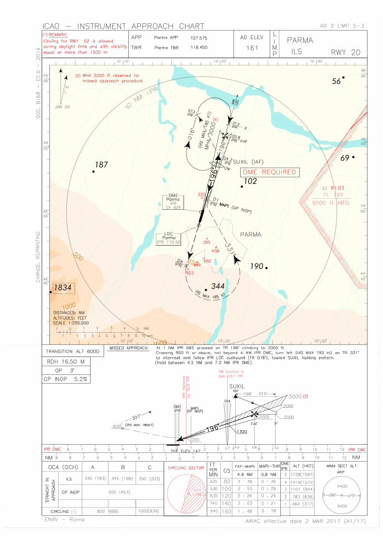
ILS RWY 20LOCCAT I
(1° E-2005.0)IPR 110.50
MHZ H24 44°48'56.0''N010°17'31.9''E NIL limitazioni oltre/limitations
beyond 17 NM MRA 2500 FT
1) Fascio posteriorenon utilizzabile /Back beam notusable
DME IPR CH 42X H24 44°49'55.2''N010°17'49.9''E 49 M AMSL
25 NM/10000 FTlimitazioni a/limitations at25 NM120°/310° MRA 6000 FT310°/120° MRA 2500 FT
NIL
GP - 329.60 MHZ H24 44°49'55.1''N
010°17'51.5''E NIL NIL Slope 3°RDH:16.50 M
OM - 75.00 MHZ H24 44°53'23.4''N
010°19'29.7''E NIL NIL NIL
TVOR/DME(1° E-2005.0) TZO
111.80 MHZ
CH 55X
TVORH24 DME H24
TVOR45°33'33.3''N009°30'25.5''E
DME45°33'33.3''N009°30'25.5''E
164 M AMSL
60 NM/50000 FTlimitazioni entro/limitationswithin 10 NM020°/330° MRA 3000 FT330°/020° MRA 4500 FTlimitazioni oltre/limitationsbeyond 10 NM020°/050° MRA 12000 FT050°/080° MRA 10000 FT080°/100° MRA 5000 FT100°/300° MRA 3000 FT300°/320° MRA 5000 FT320°/020° MRA 10000 FT
1) MAINT:Quarto THU di ognimese / fourth THUeach month: 0830-1130 (0730-1030)
NDB TZO 345.00 KHZ H24 45°33'30.5''N
009°30'33.5''E NIL
50 NMlimitazioni a/limitations at50 NM050°/080° MRA 13000 FT080°/100° MRA 11000 FT100°/160° MRA 3000 FT160°/200° MRA 6000 FT200°/270° MRA 3000 FT270°/290° MRA 5000 FT290°/300° MRA 8000 FT300°/050° MRA 14000 FT
1) MAINT:Quarto WED di /fourth WED of MAYe/and NOV: 0900-1100 (0800-1000)
VORTAC(1° E-2005.0) VIL
115.80 MHZ
CH 105X
VORH24
TACAN H24
VOR45°24'28.4''N010°54'22.5''E
TACAN45°24'29.5''N010°54'24.0''E
82 M AMSL
60 NM/40000 FTlimitazioni a/limitations at40 NM060°/110° MRA 6500 FT110°/140° MRA 4000 FT140°/160° MRA 10000 FT160°/270° MRA 4000 FT270°/300° MRA 7000 FT300°/060° MRA 16500 FT
1) MAINT:Secondo e quartoWED di ogni mese/second and fourthWED each month:0800-1000 (0700-0900)
20 REGOLAMENTI DEL TRAFFICO LOCALE LOCAL TRAFFIC REGULATIONS
1 Uso preferenziale delle piste Runway preferential useNIL NIL
2 Apron ApronPer una gestione sicura dei piazzali, i piloti degli aeromobili sul piazzale100/300, devono contattare l’ufficio operazioni So.Ge.A.P. (Tel +393357469930 o via radio sulla Freq. 131.450 Mhz) prima dell’inizio delleprocedure di start-up
For the safe management of the aprons, pilots of the aircraft on theAPRON 100/300, shall contact So.Ge.A.P. operation office (Tel +393357469930 or RTF 131.450 Mhz) before beginning start-upprocedures
3 Norme per l’utilizzo delle vie di rullaggio Special rules for taxiway use1) Il raccordo B è utilizzabile solo in uscita dalla RWY 02/20. 2) Durante le operazioni di decollo e atterraggio non sono consentiti
ACFT e veicoli sulle holding positions delle TWY A e B.
1) Taxiway B is usable for runway 02/20 exit only. 2) During take off and landing operations, ACFT and vehicles are
not allowed at holding positions of TWY A and B.4 Procedure applicabili agli aeromobili in condizioni di visibilità
ridotta (AWO)Aircraft procedures in reduced visibility conditions (AWO)
1) Generalità 1) GeneralLe procedure di bassa visibilità (LVP) saranno applicate alle operazionidi avvicinamento ed atterraggio di precisione ed alle operazioni didecollo alle seguenti condizioni:
Low visibility procedures (LVP) will be applied to precision approachand landing and departure operation at the following conditions:
Tipo di radioassistenza
Type of aid
CAT di/of ILS(VAR ILS/VOR)
ID FREQ OrarioOperational
hours
Coordinateantenna
Antenna site coordinates
(WGS84)
Elevazioneantenna
DMEElevation of
DME antenna
Copertura operativanominale
LimitazioniDesignated operational
coverageLimitations
NoteRemarks
1 2 3 4 5 6 7 8
AD 2 LIMP 1-7
04 JAN 2018 (A12/17)

ENAV - Roma
AIP - Italia
AIRAC effective date
a) quando il valore di RVR riportato al TDZ è uguale o inferiorea 550 m
a) the reported TDZ RVR value is equal or less than 550 m
b) quando la base delle nubi è inferiore a 200 ft in accordo allocale riporto meteorologico
b) cloud base is below 200 ft according to themeteorological local report
c) quando il rapido deterioramento delle condizioni meteo neraccomanda l'attivazione
c) the rapid deterioration of weather conditionsrecommends so
I piloti saranno informati dell'attivazione delle LVP tramitetrasmissione via RTF.
Pilots will be informed by RTF when LVP are in force.
La pista 20 è abilitata ad operazioni di CAT I. Runway 20 is suitable for CAT I operations.La pista 02 è abilitata ai decolli con valori di RVR non inferiori a 400 m. Runway 02 is suitable for departure operations with RVR not less
than 400 m.In condizioni di scarsa visibilità è prevedibile una riduzione dellacapacità aeroportuale a causa delle restrizioni applicate allamovimentazione al suolo.
In case of poor visibility conditions a reduced airport capacity isexpected due to restrictions applied on ground movements.
2) Movimentazione al suolo 2) Ground movementsQualora le condizioni siano tali da non permettere alla TWR ilmonitoraggio visivo di tutta o parte dell'area di manovra è consentito ilmovimento di un solo aeromobile alla volta.
Whenever conditions are such that all or part of the manoeuvringarea cannot be visually monitored from the TWR, only onemovement at a time is allowed.
a) Aeromobili in arrivo: a) Arriving aircraft:i piloti dovranno riportare alla TWR non appena liberatal'area sensibile dell'ILS (identificata dalla fine dell'alternanzadi luci verdi/gialle di asse TWY) e quando hanno raggiuntolo stand assegnato.
pilots shall report when ILS sensitive area is vacated(identified by the end of alternate green/yellow taxiwaycentre line lights) and when the assigned stand has beenreached.
b) Aeromobili in partenza b) Departing aircraft NIL NIL3) Assistenza Follow-me 3) Follow-me assistanceL’assistenza follow-me sarà disponibile su richiesta del pilota. Follow-me assistance will be available on pilot request.
5 Operazioni per l’utilizzo della pista nel tempo strettamentenecessario
Special operational practice for minimum RWY occupancy
NIL NIL6 Restrizioni locali ai voli Local flight restrictions
1) I voli addestrativi sono soggetti ai voli commerciali, di Stato,militari e di emergenza. Le informazioni sui voli schedulati sonodisponibili presso l’esercente So.Ge.A.P., tel +39 0521 951512/544
1) Training flights are subject to commercial, State, military andemergency flights. Scheduled flights information available ataerodrome operator So.Ge.A.P., tel +39 0521 951512/544
2) Atterraggi per pista 02 solamente durante le ore diurne (damezz'ora prima del sorgere del sole a mezz'ora dopo il tramonto,secondo le effemeridi locali) e con visibilità uguale o maggiore di1500 m.
2) Landing on runway 02 allowed during daylight hours only(from half an hour before sunrise until half an hour aftersunset according to local ephemerides) with visibility equal toor greater than 1500 m.
3) Decolli per pista 20 solamente durante le ore diurne (da mezz'oraprima del sorgere del sole a mezz'ora dopo il tramonto, secondole effemeridi locali) e con visibilità uguale o maggiore di 1500 m.
3) Take off on runway 20 allowed during daylight time only(from half an hour before sunrise until half an hour aftersunset according to local ephemerides) with visibility equal toor greater than 1500 m.
4) Atterraggi e decolli per pista 02/20 consentiti per entrambe lepiste in condizioni di pista asciutta, bagnata e contaminata daghiaccio/neve; deve essere applicata una riduzione del 15 percento della componente massima di vento al traverso dimostrata,pubblicata sul manuale operativo/manuale di volo adottato daglioperatori per ogni tipo di aeromobile.
4) Landing and take-off on RWY 02/20 allowed for both RWYwith RWY dry, wet and contaminated by ice/snow; it shall beapplied a 15 per cent reduction from maximum demonstratedcrosswind component, published on the operational manual/flight manual adopted by the operators for each type ofaircraft.
7 Disposizioni per gli aeromobili dell’aviazione generale Provisions for general aviation aircraftA causa della mancanza di parcheggi, si accettano voli dell'aviazionegenerale solo PPR in base alla disponibilità degli stands. Per richiedereclearance contattare 24 ore in anticipo la Società di Handling Tel +390521 951512/951511, Fax +39 0521 951530, indirizzo SITA:PMFKKXH. Traffico non soggetto a PPR: voli di linea, voli ospedale, voliemergenza e aeromobili di base con propria area parcheggio.
Due to lack of stands, general aviation flights accepted only PPRdepending on stands availability. For clearance contact HandlingAgent Tel +39 0521 951512/951511, Fax +39 0521 951530, SITAaddress: PMFKKXH with a 24 HR advance notice. Traffic notaffected: scheduled, hospital, emergency and home based aircraftowing a specific parking area.
8 Avaria radio sull’area di manovra Radio failure on manoeuvring areaOgni qualvolta un aeromobile che operi sull'area di manovra si trovi inuna situazione di avaria radio - indipendentemente dalle condizioni divisibilità in atto - dovrà comportarsi come segue:
Whenever an aircraft operating in the manoeuvering areaexperiences a communication failure - regardless of visualconditions - it shall comply with the following:
Aeromobile in partenza: Departing aircraft:continuerà sul percorso assegnato, ponendo particolare attenzionenell'evitare ogni deviazione, fino a raggiungere la posizionecorrispondente alla sua clearance limit, dove rimarrà in attesa delfollow-me per ritornare al parcheggio
shall continue on the assigned taxi route to its clearance limit andwait for the arrival of the follow-me car in order to be guided backto the stand
Aeromobile in arrivo: Arriving aircraft:libererà la pista e rimarrà in attesa del follow-me per il parcheggio shall vacate the runway and wait for the arrival of the follow-me
car in order to be guided to the stand
21 PROCEDURE ANTIRUMORE NOISE ABATEMENT PROCEDURES
1 Generalità GeneralNIL NIL
2 Uso delle piste Use of RWY1) Partenze 1) Departures
NIL NIL2) Arrivi 2) Arrivals
NIL NIL3) Restrizioni notturne 3) Night restrictions
NIL NIL3 Restrizioni al suolo Ground restrictions
1) Spinta inversa 1) ReverseNIL NIL
2) APU 2) APUNIL NIL
3) Prove Motori 3) Engine run upsNIL NIL
AD 2 LIMP 1-8
04 JAN 2018 (A12/17)
ENAV - Roma
AIP - Italia
AIRAC effective date
4 Attività addestrativa Training activityNIL NIL
22 PROCEDURE DI VOLO FLIGHT PROCEDURES
1 GENERALITA’ GENERALNIL NIL
2 PROCEDURE PER I VOLI IFR PROCEDURES FOR IFR FLIGHTS2.1 Informazioni generali General information
Il traffico in arrivo può essere soggetto a ritardi a causa del traffico inpartenza con "slot" assegnato.
Arriving traffic may be subject to delays due to departing trafficunder "slot" time restriction.
2.2 Arrivi Arrivals1) Procedure di entrata 1) Entry procedures
Descrizione delle STAR: vedi tabella 24 STAR description: see table 242) Procedure di attesa/discesa/mancato avvicinamento 2) Holding/approach/missed approach procedures
NIL NIL3) Controllo delle velocità 3) Speed control
NIL NIL4) Procedure di radio-avaria 4) Radio-failure
In caso di avaria radio, il punto di riporto designato su cuiiniziare la discesa per l’atterraggio è SUXIL
In the event of radio failure the reporting point designated todescend for landing is SUXIL
2.3 Partenze Departures1) Informazioni generali 1) General information
NIL NIL2) Procedure per la messa in moto 2) Start-up procedures
NIL NIL3) Procedure di uscita 3) Exit procedures
Procedure di salita iniziale e SID: vedi tabella 24 Initial Climb procedures and SID: see table 244) Controllo delle velocità 4) Speed control
NIL NIL3 PROCEDURE RADAR RADAR PROCEDURES
3.1 Informazioni generali General informationNIL NIL
3.2 Caratteristiche operative Operational characteristics1) Uso del radar nel Servizio di Controllo di Aerodromo 1) Use of radar in Aerodrome Control Service
NIL NIL2) Uso del radar per i movimenti di superficie (SMR) 2) Use of radar for surface movements (SMR)
NIL NIL3.3 Caratteristiche tecniche Technical characteristics
NIL NIL3.4 Radar avaria Radar failure
NIL NIL4 PROCEDURE PER I VOLI VFR PROCEDURES FOR VFR FLIGHTS
4.1 Informazioni generali General informationVedi ENR 6.3-5Rotte e punti di attesa VFR per velivoli in sorvolo o diretti all'aeroportodi Parma:
Vedi ENR 6.3-5VFR routes and holding points for aircraft overflying or bound toParma airport:
a) SORAGNA (MPNW2) - SISSA (MPN1) - COLORNO (MPNE2) - BRESCELLO (MPNE1) (discrezione ATC/ discretion) e/and viceversa
Massimo livello in rotta/Maximum enroute level:1000 ft AGL
b) FONTANELLATO (MPNW1) - PONTE TARO (MPW1) - COLLECCHIO (MPSW1) - TRAVERSETOLO (MPS1) e/and viceversa
Massimo livello in rotta/Maximum enroute level:1000 ft AGL
c) COLLECCHIO (MPSW1) - SANT’ILARIO D'ENZA (MPSE1) (discrezione ATC/ discretion) e/and viceversa
Massimo livello in rotta/Maximum enroute level:1000 ft AGL
4.2 Attività di circuito Circuit activityCircuito di traffico: sempre ad Ovest RWY Traffic circuit: always West of the RWY
4.3 Arrivi ArrivalsNIL NIL
4.4 Partenze DeparturesNIL NIL
4.5 Sorvoli OverflyingNIL NIL
4.6 VFR Speciale Special VFRNIL NIL
4.7 VFR notturno VFR/NLe operazioni in VFR notturno sono vietate a tutti gli aeromobili civilieccetto gli elicotteri. (Vedi Appendice 7 Regolamento ENAC “Regoledell’aria” edizione 2 del 24.05.07)
Night VFR operations are forbidden to all civil aircraft excepthelicopters. (See Appendix 7 ENAC Regulation “Rules of the air“edition 2 dated 24.05.07)
4.8 Attività addestrativa Training activityNIL NIL
AD 2 LIMP 1-9
17 AUG 2017 (A7/17)

ENAV - Roma
AIP - Italia
AIRAC effective date
23 INFORMAZIONI AGGIUNTIVE ADDITIONAL INFORMATION
1 Concentrazione di volatili Bird concentration Presenza di volatili sull’area di manovra e nelle sue immediate
vicinanze come riportato nella tabella sottostante. Disponibile sistemadi azione deterrente.
Presence of birds on the manoeuvring area and surroundings asdetailed in the table below. Deterring action system available.
Specie
Species
Periodo
Period
Ore di maggior presenza
(LT)
Major hours presence
(LT)
Quota media di concentrazione di volatili (FT)
Average bird concentration
altitude(FT)
Grandezza degli stormi
Flock size
Aree di maggior rischio
Areas with the greatest hazard
Distribuzione nell’area di manovra
Distribution on manoeuvring
area
StornoStarling
MAR-OCT, picco/
peak in JUL0700-11001400-1900 0-150 3-800
Manto erboso (RWY Strips)Greensward(RWY Strips)
Zona centraleCentral area
PiccionePigeon NOV-DEC
0700-09001400-1800 0-100 1-100
Manto erboso(RWY Strips)Greensward(RWY Strips)
Zona NordNorth Area
GheppioKestrel SEP-OCT
0900-11001500-1800 0-100 1-40
Voli di attraversamento
RWY e RWY StripsCrossing flights RWY and RWY
Strips
Zona centraleCentral area
Gabbiano comuneBlack-headed gull JAN-FEB 1500-1700 0-300 1-400
Voli di attraversamento
RWY e RWY StripsCrossing flights RWY and RWY
Strips
Zona centraleCentral area
Gabbiano realeHerring gull OCT-NOV
0900-10001600-1700 0-300 1-400
Voli di attraversamento RWY e RWY stripsCrossing flights RWY and RWY
strips
Zone Nord Est e Nord Ovest
North East and North West areas
Airone guardabuoi Cattle Egret JUN-JUL-AUG 0800-1000 0-100 1-100
Manto erbosoGreensward
Zone Sud Ovest e Nord Est
South West and North East areas
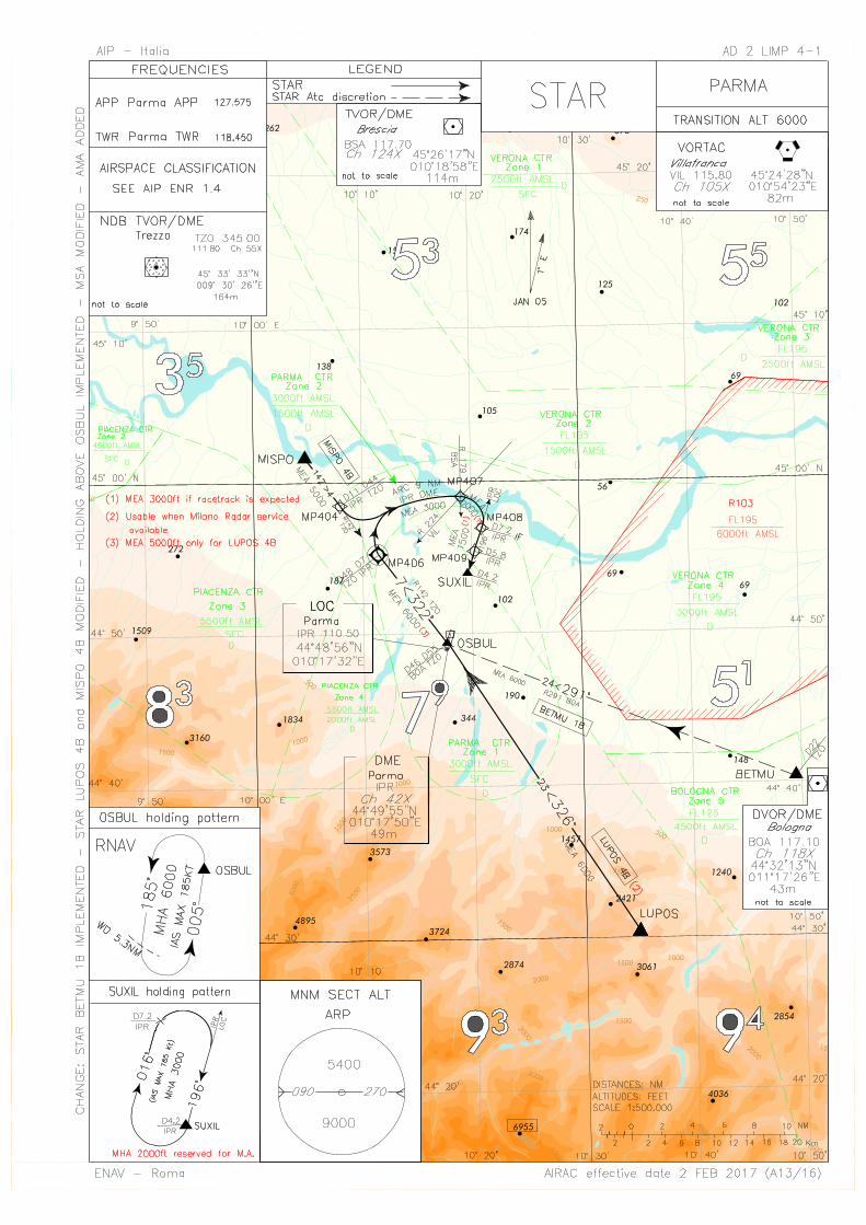
24 CARTE RELATIVE ALL’AEROPORTO DI PARMA CHARTS RELATED TO PARMA AERODROME
Carte - Charts Pagine - PagesAerodrome Chart ICAO AD 2 LIMP 2-1Aircraft Parking Docking Chart AD 2 LIMP 2-3Aerodrome Obstacle Chart - Type A ICAO RWY 02/20 AD 2 LIMP 3-1Precision Approach Terrain Chart RWY 20 AD 2 LIMP 3-3Standard Instrument Arrival Chart (STAR) AD 2 LIMP 4-1Visual Approach Chart (VAC) ICAO AD 2 LIMP 5-1Instrument Approach Chart (IAC) ICAO ILS RWY 20 AD 2 LIMP 5-3Initial Climb Procedures & SIDs Chart RWY 02 AD 2 LIMP 6-1Initial Climb Procedures & SIDs Chart RWY 20 AD 2 LIMP 6-5Aerodrome Obstacle Chart - Type B ICAO Vedi/See GEN 3.2ATC Surveillance Minimum Altitude Chart ICAO NIL
AD 2 LIMP 1-10
17 AUG 2017 (A7/17)


AIP – Italia AD 2 LIMP 4-3
ENAV – Roma AIRAC effective date 2 FEB 2017 (A13/16)
Descrizione STAR
STAR description
BETMU 1B (a discrezione ATC) BETMU – TR 291° (RDL 291 BOA VOR) per OSBUL (RDL 291/46NM BOA VOR), quindi TR 322° (RDL/QDR 142 TZO VOR/NDB) fino a MP406 (RDL/QDR 142/48 NM TZO VOR NDB/DME o INT RDL/QDR 142 TZO VOR NDB / 7NM IPR DME), quindi virare a destra per intercettare e seguire ARC 9 NM IPR DME fino a MP407, quindi virare a destra per intercettare il LOC IPR diretti al SUXIL.
BETMU 1B (ATC discretion) BETMU – TR 291° (RDL 291 BOA VOR) bound to OSBUL (RDL 291/46NM BOA VOR), then TR 322° (RDL/QDR 142 TZO VOR/NDB) until MP406 (RDL/QDR 142/48 NM TZO VOR NDB/DME or INT RDL/QDR 142 TZO VOR NDB / 7NM IPR DME), then turn right to join ARC 9 NM IPR DME until MP407, then turn right to intercept IPR LOC bound to SUXIL.
MEA: BETMU – MP406: 6000 FT; MP406 – MP407: 3000 FT; MP407 – MP408: 2000 FT (1); MP408 - SUXIL: 1500 FT (1).
(1) 3000 FT if racetrack is expected. LUPOS 4B (2) LUPOS – TR 326° per OSBUL, quindi TR 322° (RDL/QDR 142 TZO VOR NDB) fino a MP406, quindi virare a destra per intercettare e seguire ARC 9 NM IPR DME fino a MP407, quindi virare a destra per intercettare il LOC IPR diretti al SUXIL.
LUPOS 4B (2)LUPOS – TR 326° bound to OSBUL, then TR 322° (RDL/QDR 142 TZO VOR NDB) until MP406, then turn right to join ARC 9 NM IPR DME until MP407, then turn right to intercept IPR LOC bound to SUXIL.
MEA: LUPOS – OSBUL: 6000 FT; OSBUL – MP406: 5000 FT; MP406 – MP407: 3000 FT; MP407 – MP408: 2000 FT (1);
MP408 - SUXIL: 1500 FT (1).
Path Terminator
Waypoint Name
Fly Over
Track °Mag
Turn Direction
MEA Speed Limit
Recommended Navaid
Bearing/ Range to Navaid
Navigation Performance
IF LUPOS - - - - - - - P-RNAV
TF OSBUL - 326° - 6000 - - - P-RNAV
TF MP406 Y 322° - 5000 - - - P-RNAV
- MP407 - - - 3000 200 IPR DME ARC 9 NM IPR
DME Conventional
- MP408 - - - 2000 (1)
- IPR LOC/DME 016° IPR
LOC/7.2 NM IPR DME
Conventional
- MP409 - 196° - 1500 (1)
- IPR LOC/DME 016° IPR
LOC/5.8 NM IPR DME
Conventional
- SUXIL - 196° - 1500 (1)
- IPR LOC/DME 016° IPR
LOC/4.2NM IPR DME
Conventional
(1) 3000 FT if racetrack is expected (2) Utilizzabile quando disponibile Milano Radar /Usable when Milano Radar service available MISPO 4B MISPO – TR 142° (RDL/QDR 142 TZO VOR NDB) fino a MP404 (RDL/QDR 142/44 NM TZO VOR NDB/DME o INT RDL/QDR 142 TZO VOR NDB /11NM IPR DME), quindi virare a sinistra per intercettare e seguire ARC 9 NM IPR DME fino a MP407, quindi virare a destra per intercettare il LOC IPR diretti al SUXIL.
MISPO 4BMISPO – TR 142° (RDL/QDR 142 TZO VOR NDB) until MP404 (RDL/QDR 142/44 NM TZO VOR NDB/DME or INT RDL/QDR 142 TZO VOR NDB /11NM IPR DME), then turn left to join ARC 9 NM IPR DME until MP407, then turn right to intercept IPR LOC bound to SUXIL.
MEA: MISPO – MP404: 5000 FT; MP404 – MP407: 3000 FT; MP407 – MP408: 2000 FT (1); MP408 – SUXIL: 1500 FT (1).
(1) 3000 FT if racetrack is expected

AD 2 LIMP 4-4 AIP – Italia
AIRAC effective date 2 FEB 2017 (A13/16) ENAV – Roma
Holding RNAV OSBUL
Path Terminator
Waypoint Name
Inbound Course °M (°T)
Leg Distance
(NM)
Timing(min.)/ Waypoint Distance
(NM)
Turn Direction
Minimum Altitude
(FT)
Maximum Altitude
(FL)
Speed Limit (kt)
Magnetic Variation
(°)
Navigation Performance
HM OSBUL 005
(006) 4.0 – /5.3 L 6000 - 185 -1.0 RNAV 1
Waypoints Table formatted according ARINC 424 standards
Waypoint Latitude Longitude
MP404 N44582620 E010080174
MP406 N44551371 E010112457
MP407 N44585318 E010185779
MP408 N44564577 E010205893
MP409 N44551988 E010202101


AIP – Italia AD 2 LIMP 6-3
ENAV - Roma AIRAC effective date 2 FEB 2017 (A13/16)
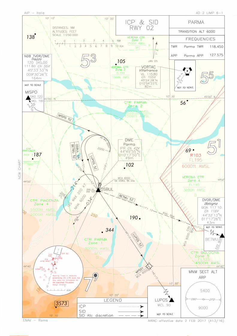
NOTE GENERALI
1. Gradiente minimo di salita: 486 ft/NM (8.0%) fino a lasciare
6000 ft.
2. Durante la salita iniziale i piloti dovranno adottare un gradiente minimo di salita conforme a quanto previsto dall’ANNESSO 6 dell’ICAO, per un sicuro sorvolo degli ostacoli e tale gradiente dovrà essere mantenuto in ogni circostanza prevedibile.
3. Gli aeromobili equipaggiati in accordo alla specifica di navigazione RNAV1 o RNP1 possono usare la codifica riportata nelle tabelle sottostanti. Le SID sono volabili in accordo alle specifiche di navigazione RNAV 1 solo se è disponibile il Servizio Radar.
4. Gli operatori non approvati per operazioni RNAV1/RNP1 potranno volare le SID sotto riportate, così come descritte, raggiungendo 6000 ft entro 10NM dal campo e quindi attendersi vettoramento da parte di MILANO ACC.
GENERAL REMARKS
1. Minimum climb gradient: 486 ft/NM (8.0%) until leaving 6000 ft.
2. During the initial climb pilots shall adopt a minimum climb gradient, in accordance with ICAO ANNEX 6, provisions for a safe obstacles overflying. Such climb gradient shall be maintained in any foreseeable circumstance.
3. Aircraft equipped according to RNAV1 or RNP1 specification may use the suggested coding reported below. SID may be flyed according to RNAV 1 specification only if Radar Service is available.
4. The operators not approved for RNAV1/RNP1 may fly the below
reported SID, as published, reaching 6000 ft within 10NM from the field and then expect radar vectoring by MILAN ACC.
DESCRIZIONE PROCEDURA DI SALITA INIZIALE RWY 02
INITIAL CLIMB PROCEDURE RWY 02 DESCRIPTION
Dopo il decollo procedere su TR 016° fino a lasciare 2000 ft, quindi virare a sinistra per inserirsi nella SID assegnata.
1. IAS MAX 200 kt durante la virata
After take-off proceed on TR 016° until leaving 2000 ft, then turn left to join the assigned SID.
1. IAS MAX 200 kt during turn
DESCRIZIONE SID RWY 02 Eseguita la procedura di salita iniziale:
SID DESCRIPTION RWY 02
Initial climb procedure executed:
BETMU 5Z (a discrezione ATC) Procedere su TR 172° fino ad intercettare e seguire RDL/QDR 142 TZO VOR/NDB (TR 142°) per OSBUL (RDL/QDR 142/55NM TZO VOR NDB/DME) quindi seguire RDL 291 BOA VOR (TR111°) per il BETMU (RDL 291/22 NM BOA VOR/DME).
BETMU 5Z (ATC discretion)
Proceed on TR 172° until joining RDL/QDR 142 TZO VOR/NDB (TR 142°) to OSBUL (RDL/QDR 142/55NM TZO VOR NDB/DME), then follow RDL 291 BOA VOR (TR111°) inbound BETMU (RDL 291/22 NM BOA VOR/DME).
MCA: RDL 291/34NM BOA VOR DME: 6000FT.
LUPOS 5Z
Path Terminator
Waypoint Name
Fly Over
Track °Mag
Turn Direction
Altitude Constraint
(MCA)
Speed Limit (IAS)
Recommended
Navaid
Bearing/ Range to Navaid
Navigation Performance
CA - - 016° - 2000 - - - RNAV1/RNP1
(vedi nota 4/see remark 4)
DF OSBUL - - L - 200 - - RNAV1/RNP1
(vedi nota 4/see remark 4)
TF MP501 - 146° - 6000 - - - RNAV1/RNP1
(vedi nota 4/see remark 4)
TF LUPOS - 146° - FL 90 - - - RNAV1/RNP1(ve
di nota 4/see remark 4)
MISPO 5Z Intercettare RDL/QDR 142 TZO VOR NDB (TR322°) per il MISPO (RDL/QDR 142/40NM TZO VOR NDB/DME).
MISPO 5Z
Join RDL/QDR 142 TZO VOR NDB (TR322°) inbound MISPO (RDL/QDR 142/40NM TZO VOR NDB/DME).
MCL: MISPO: FL100
Path Terminator
Waypoint Name
Fly Over
Track °Mag
Turn Direction
Altitude Constraint
(MCA)
Speed Limit (IAS)
Recommended Navaid
Bearing/ Range to Navaid
Navigation Performance
CA
- - 016° - 2000 - - - Conventional/RNAV1/RNP1
CF MISPO - 322° - FL100 200 TZO VOR/DME RDL142/40
NM Conventional/RNAV1/RNP1

AD 2 LIMP 6-4 AIP – Italia
AIRAC effective date 2 FEB 2017 (A13/16) ENAV - Roma
OSBUL 5N Procedere su TR 172° fino ad intercettare e seguire RDL/QDR 142 TZO VOR/NDB (TR 142°) per OSBUL (RDL/QDR 142/55NM TZO VOR NDB/DME) da raggiungere a 6000 ft o al di sopra, quindi salire in circuito di attesa fino a raggiungere il MEL previsto per il tratto successivo di AWY o altro FL autorizzato da Milano ACC.
OSBUL 5N
Proceed on TR 172° until joining RDL/QDR 142 TZO VOR/NDB (TR 142°) to OSBUL (RDL/QDR 142/55NM TZO VOR NDB/DME), to be reached at 6000 ft or above , then climb in the holding pattern until reaching MEL for next AWY segment or FL cleared by Milano ACC.
MCA: OSBUL: 6000FT.
Path Terminator
Waypoint Name
Track °Mag
Turn Direction
Altitude Constraint
Speed Limit
Recommended
Navaid
Bearing/ Range to Navaid
Navigation Performance
HM OSBUL 034° L 6000 FT 200 VIL
VORTAC RDL 214/44
NM Conventional
Waypoints Table formatted according ARINC 424 standards
Waypoint Latitude Longitude
MP501 N44400664 E010255976

AIP – Italia AD 2 LIMP 6-7
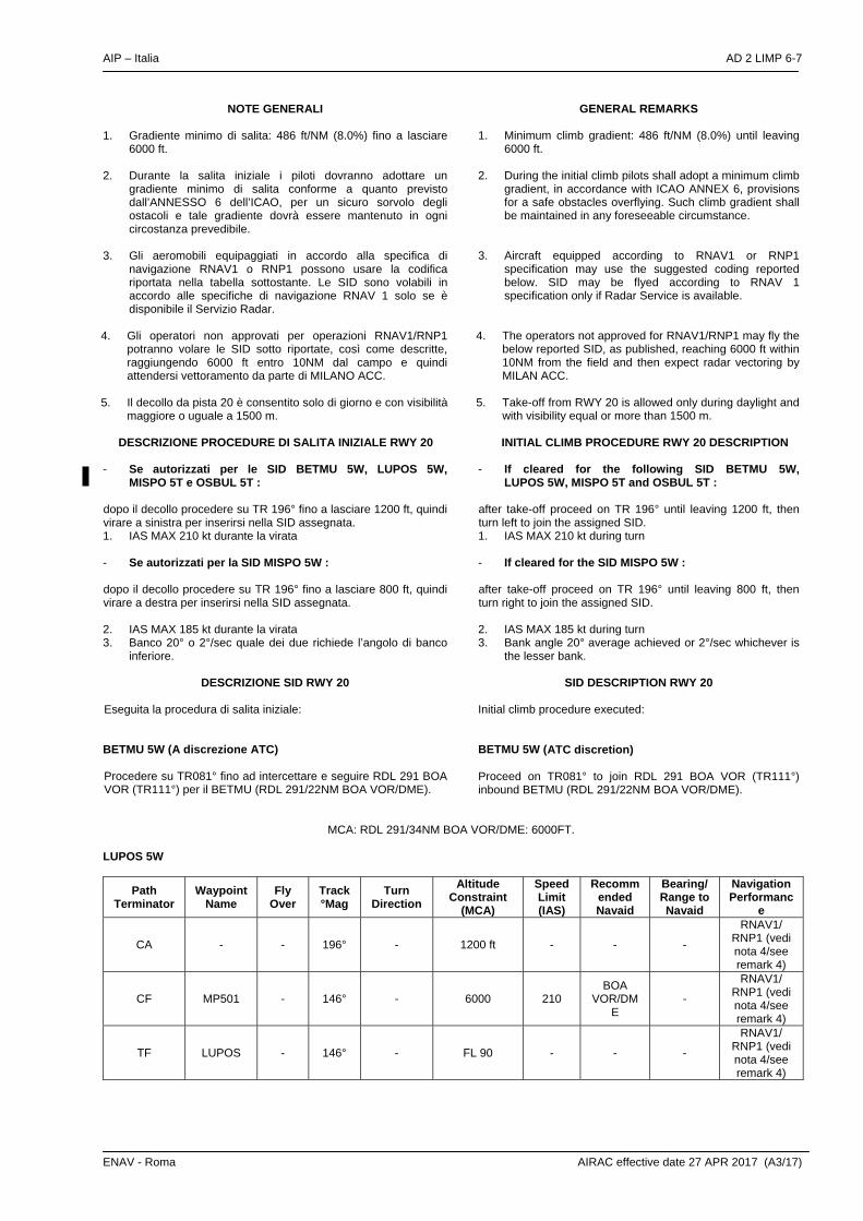
ENAV - Roma AIRAC effective date 27 APR 2017 (A3/17)
NOTE GENERALI
1. Gradiente minimo di salita: 486 ft/NM (8.0%) fino a lasciare 6000 ft.
2. Durante la salita iniziale i piloti dovranno adottare un gradiente minimo di salita conforme a quanto previsto dall’ANNESSO 6 dell’ICAO, per un sicuro sorvolo degli ostacoli e tale gradiente dovrà essere mantenuto in ogni circostanza prevedibile.
3. Gli aeromobili equipaggiati in accordo alla specifica di navigazione RNAV1 o RNP1 possono usare la codifica riportata nella tabella sottostante. Le SID sono volabili in accordo alle specifiche di navigazione RNAV 1 solo se è disponibile il Servizio Radar.
4. Gli operatori non approvati per operazioni RNAV1/RNP1 potranno volare le SID sotto riportate, così come descritte, raggiungendo 6000 ft entro 10NM dal campo e quindi attendersi vettoramento da parte di MILANO ACC.
5. Il decollo da pista 20 è consentito solo di giorno e con visibilità maggiore o uguale a 1500 m.
GENERAL REMARKS
1. Minimum climb gradient: 486 ft/NM (8.0%) until leaving 6000 ft.
2. During the initial climb pilots shall adopt a minimum climb gradient, in accordance with ICAO ANNEX 6, provisions for a safe obstacles overflying. Such climb gradient shall be maintained in any foreseeable circumstance.
3. Aircraft equipped according to RNAV1 or RNP1 specification may use the suggested coding reported below. SID may be flyed according to RNAV 1 specification only if Radar Service is available.
4. The operators not approved for RNAV1/RNP1 may fly the below reported SID, as published, reaching 6000 ft within 10NM from the field and then expect radar vectoring by MILAN ACC.
5. Take-off from RWY 20 is allowed only during daylight and with visibility equal or more than 1500 m.
DESCRIZIONE PROCEDURE DI SALITA INIZIALE RWY 20
INITIAL CLIMB PROCEDURE RWY 20 DESCRIPTION
- Se autorizzati per le SID BETMU 5W, LUPOS 5W, MISPO 5T e OSBUL 5T :
dopo il decollo procedere su TR 196° fino a lasciare 1200 ft, quindi virare a sinistra per inserirsi nella SID assegnata. 1. IAS MAX 210 kt durante la virata - Se autorizzati per la SID MISPO 5W : dopo il decollo procedere su TR 196° fino a lasciare 800 ft, quindi virare a destra per inserirsi nella SID assegnata. 2. IAS MAX 185 kt durante la virata 3. Banco 20° o 2°/sec quale dei due richiede l’angolo di banco
inferiore.
- If cleared for the following SID BETMU 5W, LUPOS 5W, MISPO 5T and OSBUL 5T :
after take-off proceed on TR 196° until leaving 1200 ft, then turn left to join the assigned SID. 1. IAS MAX 210 kt during turn - If cleared for the SID MISPO 5W : after take-off proceed on TR 196° until leaving 800 ft, then turn right to join the assigned SID. 2. IAS MAX 185 kt during turn 3. Bank angle 20° average achieved or 2°/sec whichever is
the lesser bank.
DESCRIZIONE SID RWY 20 Eseguita la procedura di salita iniziale:
SID DESCRIPTION RWY 20
Initial climb procedure executed:
BETMU 5W (A discrezione ATC) Procedere su TR081° fino ad intercettare e seguire RDL 291 BOA VOR (TR111°) per il BETMU (RDL 291/22NM BOA VOR/DME).
BETMU 5W (ATC discretion) Proceed on TR081° to join RDL 291 BOA VOR (TR111°) inbound BETMU (RDL 291/22NM BOA VOR/DME).
MCA: RDL 291/34NM BOA VOR/DME: 6000FT.
LUPOS 5W
Path Terminator
Waypoint Name
Fly Over
Track °Mag
Turn Direction
Altitude Constraint
(MCA)
Speed Limit (IAS)
Recommended Navaid
Bearing/ Range to Navaid
Navigation Performanc
e
CA - - 196° - 1200 ft - - -
RNAV1/ RNP1 (vedi nota 4/see remark 4)
CF MP501 - 146° - 6000 210 BOA
VOR/DME
-
RNAV1/ RNP1 (vedi nota 4/see remark 4)
TF LUPOS - 146° - FL 90 - - -
RNAV1/ RNP1 (vedi nota 4/see remark 4)

AD 2 LIMP 6-8 AIP – Italia
AIRAC effective date 27 APR 2017 (A3/17) ENAV - Roma
MISPO 5T Procedere per OSBUL (RDL/QDR 142/55NM TZO VOR NDB/DME) da lasciare su RDL/QDR 142 TZO VOR NDB (TR322°) per il MISPO (RDL/QDR 142/40NM TZO VOR NDB/DME).
MISPO 5T Proceed inbound OSBUL (RDL/QDR 142/55NM TZO VOR NDB/DME) to leave on RDL/QDR 142 TZO VOR NDB (TR322°) bound to MISPO (RDL/QDR 142/40NM TZO VOR NDB/DME).
MCA/MCL: OSBUL, 3000FT; MP502: 5000 FT; MISPO: FL100
Path Terminator
Waypoint Name
Fly Over
Track °Mag
Turn Direction
Altitude
Constraint (MCA)
Speed Limit (IAS)
Recommended Navaid
Bearing/ Range to Navaid
Navigation Performance
CA - - 196° - 1200 ft - - - Conventional/ RNAV1/RNP1
DF OSBUL - - L 3000 210 TZO
VOR/DME
RDL 142/55
NM
Conventional/ RNAV1/RNP1
TF MP502 - 322° - 5000 - TZO
VOR/DME
RDL 142/45
NM
Conventional/ RNAV1/RNP1
TF MISPO - 322° - FL 100 - TZO
VOR/DME
RDL 142/40
NM
Conventional/ RNAV1/RNP1
MISPO 5W (a discrezione ATC) Intercettare e seguire RDL/QDR 142 TZO VOR/NDB (TR322°) per il punto MP502 (RDL/QDR 142/45NM TZO VOR NDB/DME quindi procedere per il MISPO (RDL/QDR 142/40NM TZO VOR NDB/DME).
MISPO 5W (ATC discretion) Joining RDL/QDR 142 TZO VOR/NDB (TR322°) to MP502 (RDL/QDR 142/45NM TZO VOR NDB/DME then proceed inbound MISPO (RDL/QDR 142/40NM TZO VOR NDB/DME).
MCA/MCL: MP502: 5000 FT; MISPO: FL100
Path Terminator
Waypoint Name
Fly Over
Track °Mag
Turn Direction
Altitude Constraint
(MCA)
Speed Limit (IAS)
Recommended
Navaid
Bearing/ Range to Navaid
Navigation Performance
CA - - 196° - 800 ft - - - Conventional/ RNAV1/RNP1
CF MP502 - 322° R 5000 185 TZO
VOR/DME
RDL 142/45
NM
Conventional/ RNAV1/RNP1
TF MISPO - 322° - FL 100 - TZO
VOR/DME
RDL 142/40
NM
Conventional/ RNAV1/RNP1

AIP – Italia AD 2 LIMP 6-9
ENAV - Roma AIRAC effective date 2 FEB 2017 (A13/16)
OSBUL 5T Procedere su TR 336° quindi intercettare e seguire IPR LOC (TR 016°) per SUXIL (016° IPR LOC/4.2NM IPR DME) da raggiungere a 5000 ft o al di sopra, quindi virare a sinistra su TR 172° fino ad intercettare e seguire RDL/QDR 142 TZO VOR/NDB (TR 142°) per OSBUL (RDL/QDR 142/55NM TZO VOR NDB/DME) e salire in circuito di attesa fino a raggiungere il MEL previsto per il tratto successivo di AWY o altro FL autorizzato da Milano ACC.
OSBUL 5T Proceed on TR 336° to join and follow IPR LOC (TR 016°) to SUXIL (016° IPR LOC/4.2NM IPR DME) to be reached at 5000 ft or above, then turn left on TR 172° until joining RDL/QDR 142 TZO VOR/NDB (TR 142°) to OSBUL (RDL/QDR 142/55NM TZO VOR NDB/DME), and climb in the holding pattern until reaching MEL for next AWY segment or FL cleared by Milano ACC.
MCA/MCL: SUXIL, 5000FT; OSBUL: 6000FT o come autorizzato da Milano ACC/or as cleared by Milano ACC.
Path Terminator
Waypoint Name
Fly Over
Track °Mag
Turn Direction
Altitude Constraint
(MCA)
Speed Limit (IAS)
Recommended Navaid
Bearing/ Range to Navaid
Navigation Performance
CA - - 196° - 1200 ft - - - Conventional/RNAV1/RNP1
CF SUXIL Y 016° L 5000 210 IPR LOC - Conventional/RNAV1/RNP1
CF OSBUL - 142° L 6000 210 TZO
VOR/DME
RDL 142/55
NM
Conventional/RNAV1/RNP1
Path Terminator
Waypoint Name
Track °Mag
Turn Direction
Altitude Constraint
Speed Limit
Recommended
Navaid
Bearing/ Range to Navaid
Navigation Performance
HM OSBUL 034° L 6000 FT 200 VIL
VORTAC RDL
214/44 NM Conventional
Waypoints Table formatted according ARINC 424 standards
Waypoint Latitude Longitude
MP501 N44400664 E010255976
MP502 N44572534 E010090481

Intenzionalmente bianca
Intentionally left blank