Embed Size (px)
Citation preview
Urban Fringe Subarea
Comprehensive Plan, Land Use Element September 1997
Amended 1999, 2004, 2009
Whatcom County Executive
Pete Kremen
Whatcom County Council
Barbara Brenner Alvin Starkenburg
Tom Brown Kathy Sutter Ward Nelson, Chair Robert Imhof Marlene Dawson
Whatcom County Planning Commission
Rod Erickson David Simpson Gerald Landcastle, Chair Sam Crawford
Danna Beech Cheryl Ferrier Richard Gilda Bob Wiesen Rob Ney
Whatcom County Planning & Development Services Department
Michael Knapp, Director
Sylvia Goodwin, Manager Carl F. Batchelor, Senior Planner, Project Manager
Jeff Griffin, Senior Planner Elizabeth Olsen, Planner II Sarah Watts, Planner II GIS Chris Behee, Planner I GIS Amy deVera, Planning Technician Sue Blake, Water Planner
Jane Doughty, Administrative Secretary Becky Garney, Clerk III
Whatcom County Planning Northwest Annex
5280 Northwest Drive
Bellingham, WA 98226-9094 (360) 676-6907
City of Bellingham
Bellingham Mayor Mark Asmundson
Bellingham City Council
Bruce Ayers Arne Hanna Louise Bjornson Gene Knutson Pat Rowe, Chair Bob Hall Bob Ryan
Bellingham Planning & Community Development Department
Patricia R. Decker, Director Pat Carman, Planner II, Project Manager
Greg Aucutt, AICP, Senior Planner Chris Koch, Planner I Chris Spens, AICP, Senior Planner Brian Smart, Planner I
Marilyn Vogel, Planner III Kim Hyatt, Wetlands/Water Jackie Lynch, AICP, Planner II Susan Larssen, Admin. Sec.
Denise Holz, Planner II Barbara Pearson, Secretary Kathy Bell, Planner I Laurie Foy, Secretary II
Bellingham Planning & Community Development Department Bellingham City Hall
210 Lottie Street Bellingham, WA 98225
(360) 676-6982
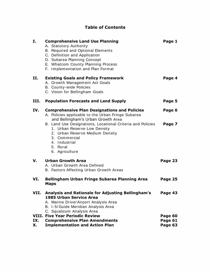
Table of Contents I. Comprehensive Land Use Planning Page 1
A. Statutory Authority B. Required and Optional Elements
C. Definition and Application D. Subarea Planning Concept E. Whatcom County Planning Process
F. Implementation and Plan Format
II. Existing Goals and Policy Framework Page 4 A. Growth Management Act Goals B. County-wide Policies
C. Vision for Bellingham Goals
III. Population Forecasts and Land Supply Page 5 IV. Comprehensive Plan Designations and Policies Page 6
A. Policies applicable to the Urban Fringe Subarea and Bellingham’s Urban Growth Area
B. Land Use Designations, Locational Criteria and Policies Page 7 1. Urban Reserve Low Density 2. Urban Reserve Medium Density
3. Commercial 4. Industrial
5. Rural 6. Agriculture
V. Urban Growth Area Page 23 A. Urban Growth Area Defined
B. Factors Affecting Urban Growth Areas
VI. Bellingham Urban Fringe Subarea Planning Area Maps
Page 25
VII. Analysis and Rationale for Adjusting Bellingham’s 1985 Urban Service Area
Page 43
A. Marine Drive/Airport Analysis Area B. I-5/Guide Meridian Analysis Area C. Squalicum Analysis Area
VIII. Five Year Periodic Review Page 60 IX. Comprehensive Plan Amendments Page 61
X. Implementation and Action Plan Page 63
1
Urban Fringe Subarea
Comprehensive Plan Update
Amendment-Update to the Whatcom County Comprehensive Plan
For the Urban Fringe Subarea Including the portion of Bellingham’s Northern Urban Growth Area
I. Comprehensive Land Use Planning Introduction
A. Statutory Authority
Statutory authority for county comprehensive land use planning is established in the Washington State Planning Enabling Act, RCW 36.70 in
which it is stated that "each planning agency shall prepare a comprehensive plan for the orderly physical development of the county
or any portion thereof." The 1984 Urban Fringe Subarea Comprehensive Plan that was developed in response to this authority, as well as in recognition of the principle that Whatcom County land use decisions should
be made in a coordinated and responsible manner by both the public and private sectors, envisioned a review and update of the Plan every five
years. Subarea planning recognizes the diversity of communities, life styles and interests in Whatcom County. It affords citizens a more direct influence
in the planning for their particular community. B. Required and Optional Elements
The Planning Enabling Act RCW 36.70A and the Growth Management Act,
provide counties with a list of required and optional elements to include in their Comprehensive Plan. Required elements include a Land Use Element indicating the distribution, location, and extent of the uses of land for
agriculture, timber production, housing, commerce, industry, recreation, open spaces, public utilities, and public facilities. Plans should also include
provisions and standards for population densities, building intensities, estimates of future population growth, protection of quality and quantity of ground water used for public water supplies, and review drainage, flooding,
storm water runoff & Puget Sound water quality. Other required elements are housing, capital facilities, utilities, rural lands, and transportation.
Optional elements include conservation, solar energy, and recreation. In addition to these elements, counties must classify, designate, and
preserve agricultural, forestry, and mineral resource lands of long term significance. The Urban Fringe Subarea Plan is the Land Use Plan for the
Subarea and Bellingham's Urban Growth Area.
2
C. Definition and Application
The Whatcom County Comprehensive Plan is defined as an official public document to be utilized by both the public and private sectors as a policy
guideline for making orderly and desirable decisions concerning the future use of land in the county. The plan has been formulated by the Whatcom County Planning Commission and is comprehensive, general and long-range
in nature. Comprehensive, in that it encompasses major geographic areas of the county and the functional elements that bear on physical
development; general, in that it summarizes major policies and proposals and is not, by statute, a detailed regulation; and long-range, in that it not only addresses current issues, but also anticipated problems and
possibilities of the future.
The purpose of this subarea plan is to foster a responsible process of land use decision-making. The goals, policies and land use plan map contained herein serve to update and amend the Whatcom County Comprehensive
Plan, particularly the 1984 Urban Fringe Subarea component of the Whatcom County Comprehensive Plan.
D. Subarea Planning Concept
Because of the county's diverse physical and cultural make-up, the Planning Commission elected to divide the western one-third of the county
into ten logical geographic areas denoted as "subareas." These geographic areas were delineated to address various land use related issues that
appeared to be unique to particular areas of the county. The criteria utilized by the Commission to delineate the subarea boundaries include natural and physical features; political subdivisions, such as special purpose districts
(sewer, water, fire, school, etc); existing land use patterns; and the presence of a city or town (where applicable) to act as a nucleus for the
area. Thus, subareas are planning units determined through the application of criteria and considered as a practical means of revising the Comprehensive Plan in a consistent orderly fashion.
E. Whatcom County Planning Process
The Whatcom County comprehensive planning process is defined as a continual program of evaluating goals, conducting various land-related
studies, and then utilizing such goals and studies to fashion a balanced and practical set of land use policies and proposals for the future use of land
in our county. Stated differently, the planning process serves as a blueprint for the logical development of the comprehensive plan, as well as the formulation of effective implementation tools.
The process describes, through a logical sequence, the various land use
related factors that must be considered to effect the formulation of responsible and meaningful land use policies and proposals. These factors
3
concern the following: the definition of county-wide goals; the inventory and analysis of land use, community facilities and utilities, transportation
facilities and environmental resource characteristics; the forecasting of population levels and the county's economic vitality; the comprehension of
issues, both technical and citizen related; the development of policies to resolve and/or address the relevant issues; and the transformation of policies into the plan map and attendant implementation tools.
The planning process is continual. It involves not only the formulation of
the comprehensive plan document and its implementation through the application and use of various regulatory tools, but also continual monitoring and periodic updating. The success of the planning process in
Whatcom County relies heavily upon the county's ability to keep the major components of the plan current. Thus, the plan should be updated every
five years by the Planning Commission and such revisions should adhere to the various sequential stages of the planning process. Issues in the Bellingham Urban Growth Area should continue to be addressed through
joint planning efforts.
F. Implementation and Plan Format
The implementation of this updated Comprehensive Plan will be accomplished by several different actions. The Comprehensive Plan Map designations will be revised in accordance with recommendations made in response to issues
and public input. This document comprises the policies that correspond to the Comprehensive Plan Map designations. A revised zoning map will be
prepared to correspond to revised Comprehensive Plan Map designations. Revisions to uses and specific regulations in the zoning ordinance may also be made in response to revised goals, policies, and issues specific to the
Urban Fringe Subarea. In addition to the above, an Interlocal Agreement between Bellingham and Whatcom County, governing policies and
procedures for annexations, utility extensions, and development in the Northern Urban Growth Area will be adapted. The Interlocal Agreement can be revised in the future to reflect changes needed in response to changing
conditions.
The results of this planning process will become two separate published documents: 1) a component of Whatcom County's Comprehensive Plan with recommendations for County zoning designations in Bellingham's
Northern Urban Growth Area of the Urban Fringe Subarea, future Bellingham zoning designations after annexation, and policies and zoning
designations for areas outside Bellingham’s Northern Growth Area; and 2) a component of Bellingham’s Comprehensive Plan which will also include Urban Growth Areas in the Lake Whatcom Subarea, and Chuckanut Lake
Samish Subarea. An Action Plan section of this Plan lists specific future actions to address issues that are important to the Subarea.
4
II. Existing Goals and Policy Framework A. Growth Management Act (GMA)
The State Legislature adopted the Growth Management Act (GMA) in 1990 and 1991, requiring jurisdictions in the fastest growing areas of the state
to update their comprehensive plans in accordance with 13 stated goals. This legislation was intended to recognize that uncoordinated and unplanned growth poses a threat to the environment, to sustainable
economic development and to the health, safety and high quality of life enjoyed by residents of this state. Planning under GMA needs to occur in a
coordinated and comprehensive manner drawing on the cooperation of related jurisdictions. Consistent with this directive, the City of Bellingham and Whatcom County have coordinated efforts through the Urban Fringe
planning process to produce decisions on appropriate future land use patterns and urban growth boundary for approximately 6,000 acres of county
land in the Urban Fringe Subarea. B. County-wide Planning Policies
As a requirement of the Growth Management Act, county-wide planning
policies are to be adopted by Whatcom County with concurrence by all cities. In compliance with this requirement, Whatcom County, Bellingham, and the other incorporated cities in Whatcom County adopted a set of
County-wide Planning Policies which establish a county-wide framework for developing and adopting city and county comprehensive plans and
assure that city and county plans are consistent. C. Visions for Bellingham Goals
As part of Bellingham's Comprehensive Plan Update process, a Visioning
process was undertaken which resulted in the Bellingham City Council adopting a set of goals to guide growth and development. These goals are
included, by reference, as part of this Plan in the interest of promoting consistency as dictated by the Growth Management Act. Called Visions for Bellingham, these goal statements provided the basis for the production of
the 1995 Bellingham Comprehensive Plan.
5
III. Population Forecasts/Land Supply Projections of future population size are an essential component of land use planning. As required by GMA, the Washington State Office of Financial
Management developed a 20-year population projection for Whatcom County. These population projections and an analysis of the capacity of
land presently zoned for residential development help determine additional land supply needs for the next 20 years of growth. By incorporating population forecasts into the planning process, Whatcom County and the
City of Bellingham will ensure, as much as possible, that future needs for employment, transportation, affordable housing, utility, parks and other
amenities will be met.
6
IV. Comprehensive Plan Designations and Policies
A. General Policies Applicable to the Urban Fringe Subarea and
Bellingham’s Urban Growth Area
The following list of policies are intended to ensure cooperation between
Whatcom County and the City of Bellingham in directing and managing urban and rural development in the Urban Fringe Subarea. In adopting these policies, both jurisdictions agree to:
1.1 Provide for land uses in the Subarea and Bellingham's Northern Urban Growth Area that conform to the Growth Management Act,
Whatcom County Goals, Visions for Bellingham, County-wide Planning Policies and other agency plans that consider the provision
of urban services to the planning area. 1.2 Promote the integrity and character of each neighborhood planning
area within Bellingham's Northern Urban Growth Area. Encourage and provide opportunities for a maximum degree of citizen participation in
the governmental planning and decision making process.
1.3 Provide opportunities for a diversity of housing types in the Urban Growth Area.
1.4 Direct new high density residential, commercial and industrial development toward existing urban development and along major
transportation routes to support land use and transportation plans. 1.5 Direct urban growth and development into areas where existing City
utilities and services are available and can be readily expanded.
1.6 Promote development that supports and enhances efficient public transportation and an intermodal transportation system.
1.7 Adopt an interlocal agreement that sets agreed upon development standards within Bellingham’s Urban Growth Area, and which may
include application of such standards as the City of Bellingham’s design and development standards and guidelines and impact fee ordinances to all development in the Urban Growth Area. Such
agreements shall undergo a full citizen involvement process.
1.8 Cooperate and coordinate with special districts and other governmental agencies to ensure efficient provision of a full range of urban services in the Urban Growth Area.
1.9 Continue joint City and County site plan review for all new
residential, commercial, industrial, and Airport Operations development in the Urban Growth Area.
7
1.10 Recognize that the City of Bellingham will be the primary
provider of urban services and facilities within its designated urban growth area.
1.11 Permit development concurrent with public facilities and services
needed to support that development.
1.12 Consistent with the adopted policy, areas in Bellingham’s UGA will be
eligible to receive city water and sewer service only in the following two circumstances:
1. Upon annexation to the City; or
2. Prior to annexation, the City Council will consider requests to extend utilities only if the proposed development uses the
County’s transfer of development rights (TDR) program to purchase or otherwise transfer development rights from the Lake Whatcom Watershed to designated development rights
from the Lake Whatcom Watershed to designated receiving areas.
1.13 Minimize land use conflicts in Urban Growth Area through the use of
appropriate buffering mechanisms, design standards, and locational criteria; and by promoting compatibility between land uses, especially among residential, commercial, industrial and Airport Operations
designations.
1.14 Designate appropriate zones within the Urban Growth Area as receiving areas for transfer of development rights from the Lake Whatcom watershed in order to promote increased densities within the
Urban Growth Area and decrease densities within the watershed to help protect water quality.
1.15 Require the purchase of transfer of development rights from the Lake
Whatcom watershed in order to rezone property to increase residential
densities.
1.16 Promote a coordinated effort to identify and prioritize interconnected natural areas and features for preservation to protect water quality and provide habitat, recreation, open space and wildlife corridors.
B. Land Use Designations, Locational Criteria and Policies
Urban Residential Designations
Urban Residential Density
2.1 The Urban Residential plan designation (UR) is located in Bellingham’s Urban Growth Area and can be urbanized at such time that a full range
8
of urban services can be efficiently provided. The primary purpose of the Urban Residential designation is to promote an orderly transition
from rural land uses and densities to urban land uses and densities.
2.2 The rationale underlying the Urban Residential Low Density
designation is to reserve certain land in the urban growth areas of cities for future urban purposes and encourage interim uses that are complementary and compatible with future urban dens i t ies and
services. The designation intends to encourage the responsible growth of urban areas by assuring that a full range of urban services
is available to support urban level densities.
2.3 Locational Criteria
Areas Appropriate for Urban Residential designation include the following:
2.3.1 Land areas adjacent to the City of Bellingham or the Urban
Service Area that are of sufficient size to adequately
accommodate the projected demands for residential and associated uses, transportation and public uses for the twenty
year planning period.
2.3.2 Land areas where a full range of urban services presently exists or can be economically and efficiently provided in the near future.
2.3.3 Areas that contain an adequate supply of vacant land suitable
for urban development.
2.3.4 The boundaries of the Urban Residential designation should be
well defined, logical, provide a physical “sense of community” and be capable of being expanded to accommodate additional
urban growth as the need arises.
2.3.5 The Urban Residential zoning district is implemented when a
full range of urban services is provided. In areas where such services do not exist, the maximum density is one dwelling
unit per ten acres. 2.4 The Urban Residential designation is intended to be urban with urban
uses and services and is to promote an orderly transition from rural land uses and densities to urban land uses and densities.
2.5 The predominant land use pattern within the Urban Residential land
use designation should be residential, allowing single family
residential, neighborhood scale commercial in specific designated areas, parks and other public uses.
9
2.6 The Urban Residential designation allows three (3) dwelling units per acre within the Lake Whatcom watershed and adjacent to Bellingham
Bay. The designation allows six (6) dwelling per acre in the Seaview area adjacent to Bellingham Bay and in the Dewey Valley east of
Hannegan Road.
2.7 Consideration should be given to design standards for development in
the Urban Residential designation. Wetland systems and sensitive areas should be preserved and incorporated into the development site
design plan. Access shall be provided on residential streets.
2.8 Existing mobile home parks will be allowed to remain as non-
conforming uses. New mobile home parks may develop at underlying density of the zone. Citing standards should be developed to allow
for location of mobile home parks and subdivisions in the future. Urban Residential - Medium Density
2.9 The Urban Residential Medium Density designation (URM) is
located in Bellingham's Urban Growth Area and can be developed at allowed densities upon annexation or with annexation agreements
in place. The designation is intended to be developed with a full range of urban services. The designation should provide for affordable housing types such as apartments, townhouses, condominiums, mobile
home parks, subdivisions and other compatible non- residential uses; with minimum net density of 10 dwelling units per acre and a
maximum gross density of 24 dwelling units per acre. 2.10 The designation promotes an orderly transition from low density uses
to higher density urban uses where predominantly residential uses complemented by compatible neighborhood scale recreation and
commercial services are appropriate.
2.11 Locational Criteria
2.11.1 The density classifications of six to twenty four units per acre
should be applied to areas in the Urban Growth Area that are either adjacent to existing or planned residential developments containing similar density levels or adjacent to existing or planned
commercial or light industrial, developments.
2.11.2 Higher density developments should be located to take advantage of good access to public transit, arterial routes of travel, and commercial services and employment centers.
2.12 The predominant land use pattern includes single family detached
dwelling units, apartments, condominiums, rooming houses, mobile home
10
parks and retirement and convalescent centers, parks and other public uses.
2.13 For those URM areas currently served by sewer and water, a mix of
housing types and densities is encouraged consistent with the adopted Plan for the Urban Growth Area.
2.14 A mix of housing types and range of densities within the URM designation is encouraged particularly in areas close to industrial,
commercial and other urban employment centers, adjacent to arterials and major connector streets, and where there is access to transit, parks and other recreational areas.
2.15 Special consideration should be given to site design for all development
in the Urban Residential Medium designation. Specific wetland systems and sensitive environmental areas should be preserved and incorporated into the development site design plan consistent with City ordinances.
Access should be from residential roads.
2.16 This designation also provides a receiving area for transfer of development rights credits.
2.17 The City of Bellingham’s design and development standards and
guidelines and impact fee ordinances shall apply to all development in the
Bellingham Urban Growth Area.
2.18 In order to develop at densities greater than ten dwelling units per acre, areas designated for provisional rezone to URM-24 all of the following must occur:
Property owner(s) shall prepare a site plan showing the design and layout
of proposed lots, multi-family structures, road and pedestrian connections to adjacent parcels, delineated wetlands, and protected critical areas, buffers and open space.
Property owner(s) shall purchase or transfer sufficient development rights
from the Lake Whatcom Watershed to achieve the requested density increase, based on the TDR ratios established in the Whatcom County Code.
Property owner(s) shall comply with City of Bellingham design and
development standards and guidelines, including residential multi-family design standards and any other conditions imposed by the City of Bellingham through approved Utility Service Zone Extension Agreements.
Property owner(s) shall apply to the County for a site-specific rezone
pursuant to Chapter 20.90 WCC in conjunction with submittal of a
11
subdivision or binding site plan application for the subject parcel or parcels.
Urban Residential – Mixed Use
2.19 It is the purpose of this zone designation to provide an orderly
transition from rural to urban development by limiting densities and
uses until services are available and then to provide for mixed uses in a manner that encourages a range of dwelling unit types and pedestrian
access to convenience shopping and jobs while maintaining an overall single family character and property values for the neighborhoods created within this designation.
2.20 Locational Criteria
Areas appropriate for Urban Residential - Mixed (UR-MX) designation include the following:
2.20.1 Land areas within the City of Bellingham's Northern Urban
Growth Area that are of sufficient size to adequately accommodate the projected demands for residential,
commercial, transportation and public uses for the twenty year planning period.
2.20.2 Land areas where a full range of urban services presently exists or can be economically and efficiently provided in the near future.
2.20.3 Areas that contain an adequate supply of vacant land suitable
for urban development.
2.21 Commercial uses will be clustered in a single center which is no larger than (2) two acres, excluding areas used for multi-family. The
commercial uses shall not exceed 2,500 square feet per building. 2.22 This designation also provides a receiving area for transfer of
development rights credits.
2.23 The Urban Residential - Mixed (UR-MX) Designation is located in Bellingham's Northern Urban Growth Area and can be developed at allowed densities upon annexation or with annexation agreements in
place. The designation is intended to be developed with a full range of urban services. The designation should provide for affordable housing
types such as apartments, townhouses, condominiums, subdivisions and other compatible non-residential uses; with a net density of at least 6 dwelling units per acre as the lowest allowable single family density.
2.24 Multi-family dwelling units shall not comprise more than 25% of the total
dwelling units in one development proposal.
12
2.25 Special consideration shall be given to site design for all
development in the Urban Residential - Mixed designation. Specific wetland systems and sensitive environmental areas shall be preserved
and incorporated into the development site design plan consistent with City ordinances.
2.26 Residential development should be located within walking distance of transit stations, designated centers, parks and recreational areas.
2.27 Establishment of neighborhood commercial centers shall require
conditional use permit approval. Once a site has been approved, the full
range of permitted uses shall be allowed.
2.28 Establishment of mobile home parks shall require conditional use permit approval.
2.29 Commercial development should occur in nodes. Linear strips will be discouraged.
2.30 Businesses in the centers will have their fronts located on collector
streets; or located adjacent to a public square or neighborhood park; and are no less than one-half mile from an existing or proposed similar center or other commercial area or zone.
2.31 Centers should be visible and accessible to pedestrians from the
streets and clearly defined through lighting, landscape, landmarks, and/or open space.
2.32 Parking will be located at the rear of the buildings with access from alleys or side streets.
Commercial Designations
3.1 The Urban Fringe Subarea Comprehensive Plan provides two types of designations in the Urban Growth Area, and addresses the needs and
opportunities for the City of Bellingham, the Urban Growth Area, and larger regional area. The policies and locational criteria for land zoned within a commercial designation, applies only to land within the
Bellingham Urban Growth Area.
General Commercial 3.2 The General Commercial designation is intended to provide a broad
range of retail goods and services that will benefit a large trade area commensurate with demand. The designation also intends to facilitate
safe and efficient circulation systems, provide methods to attain compatibility with surrounding noncommercial areas, and promote site
13
design that will efficiently use available commercial land. Building design should take into account aesthetic and compatibility concerns. The
General Commercial designation is implemented by the General Commercial zone. Comparable City zoning for the General Commercial
designation is Commercial, Planned. 3.3 Locational Criteria
Areas appropriate for the General Commercial designation should conform to the
following criteria:
3.3.1 Parcels that are served by arterials and/or collectors.
3.3.2 Parcels that have the potential of being served by urban level of
service. 3.3.3 The designation should be located where there is a public need.
3.4 Whatcom County acknowledges existing patterns of commercial uses
within the Urban Fringe Subarea. To provide for additional future commercial development, certain areas are designated General
Commercial allowing a range of commercial uses including sales and servicing of vehicles, mobile homes and boats; eating and drinking establishments; professional offices service and retail establishments;
commercial indoor and outdoor recreation; commercial wholesaling; multi-family dwellings; and public uses that are necessary for the
function of the designation. 3.5 Ensure compatibility between General Commercial developments and
the surrounding residential areas by identifying citing, design, and development standards.
3.6 Encourage the location of new commercial development in proximity
to other existing commercial uses, or oriented to serve part of a planned
development.
Neighborhood Commercial 3.7 The primary purpose of the Neighborhood Commercial is to provide
convenience goods and services to the surrounding neighborhoods. Neighborhood Commercial areas are general located in residential areas.
The Neighborhood Commercial designation is implemented by the Neighborhood Commercial zone. Comparable City zoning would be Neighborhood Commercial.
3.8 Locational Criteria
Areas suitable for the Neighborhood Commercial designation should conform
14
to the following criteria:
3.8.1 Parcels are served by arterials or collector streets. The designation is centrally located to the neighborhood it would serve.
3.8.2 The designation shall not exceed five (5) acres.
3.8.3 The designation is to be located on property where ownership patterns and land parcelization is conducive for development.
3.9 The Neighborhood Commercial designation provides convenience goods
and services to surrounding neighborhoods of urban residential densities
and should be discouraged in rural areas.
3.10 Ensure compatibility between neighborhood commercial developments and the surrounding residential areas by identifying and applying citing, design, and development standards.
Industrial Designations
4.1 The Urban Fringe Subarea Comprehensive Plan provides five types of
industrial designations: Heavy Impact Industrial, General Manufacturing, Light Impact Industrial, Gateway Industrial, and Airport Operations in the Urban Growth Area, and addresses the needs and
opportunities for the City of Bellingham, the Urban Growth Area, and the larger regional area. Each designation intends to meet a range of
industrial needs. The policies and locational criteria for land zoned within an industrial designation, applies only to land within the Bellingham Urban Growth Area.
Heavy Impact Industrial
Intent Statement:
4.2 The underlying rationale of the Heavy Impact Industrial designation in the Urban Fringe Subarea is to acknowledge existing heavy industrial
uses situated in proximity to Bennett Drive, Marine Drive, and Roeder Avenue; to endorse a diverse economic base; and to attain compatibility between industrial activities and adjoining residential land
uses.
4.3 Locational Criteria Areas appropriate for the Heavy Impact Industrial designation should
conform to the following criteria:
4.3.1 Parcels that are generally flat, well drained, with sufficient soil bearing capacities.
15
4.3.2 Parcels within the existing Heavy Impact Industrial designation
with sufficient land to provide buffers to non-industrial uses.
4.3.3 Proximity to transportation corridors (including direct access to identified truck routes not requiring the use of residential streets) and opportunities for interconnecting transportation modes
(rail, truck routes, water and air) and urban services including sewer, water, storm drainage, fire and police protection and labor
supply pools.
4.4 The Heavy Impact Industrial designation takes advantage of truck, rail,
freeway, air and water transportation access as well as proximity to potential labor pools. A full range of urban services should be available
to the heavy industrial areas including sewer, water, storm drainage, and police and fire protection. The Heavy Impact Industrial area is implemented by the Heavy Impact Industrial zone. Comparable City
zoning is Industrial, Planned. This zoning will ensure that uses allowed by Whatcom County zoning (Urban Fringe Subarea-Heavy Impact Industrial
and Light Impact Industrial) will be allowed as outright permitted uses, subject to appropriate development standards. Commercial uses will
be prohibited. 4.5 It is the policy of Whatcom County to evaluate the short and long range
impacts to existing public facility, utility and transportation systems resulting from industrial development. If it is determined that industrial
development will cause financial and physical impacts which exceed the scheduled capital improvement programs of various systems, Whatcom County shall request industrial users to financially participate in the costs
of upgrading said systems.
4.6 Whatcom County should work with the City of Bellingham to manage and improve direct truck access to and from the HII area which minimizes truck traffic flows in adjacent and surrounding residential areas situated
in the county and city.
4.7 Whatcom County shall encourage the appropriate governmental authorities, including, the Northwest Air Pollution Authority; Department of ecology and Environmental Protection Agency, to monitor pollution control
and nuisance abatement. Whatcom County should assure that the design and location of industrial development will include consideration of
pollutant sources and abatement methods, as well as environmentally sensitive areas which may be situated in or in proximity to the industrial area. The location, development, expansion and operation of industries
should move toward minimizing pollution of all forms and its impact on other areas.
16
4.8 When practical, Whatcom County encourages industrial operations to take place within enclosed structures with the intent of minimizing
potential light, glare, odors and noise impacts to adjoining residential uses.
4.9 Because the HII areas adjoins existing and planned residential areas
situated in Whatcom County and the City of Bellingham, it is
necessary to move toward obtaining mutual compatibility with said residential areas. To obtain mutual compatibility, it is the policy of
Whatcom County to permit those existing uses and future uses which will minimize hazards, pollution, nuisances and odors to surrounding residential areas. The following uses will not be permitted in the Heavy
Impact Industrial zoned district situated in the Urban Fringe Subarea: manufacturing and processing of asbestos and products derived
therefrom; petroleum refining and the primary manufacture of products derived directly therefrom; primary manufacturing of rubber, plastics, chemicals, paper, and primary metal industries. Light Impact Industrial
uses shall be allowed in Areas 1A, 1B, and 1C of the Shoreline Industrial Area.
4.10 With the intent of fostering and promoting compatibility with
surrounding residential land uses both in the county and the City of Bellingham, it is the policy of Whatcom County to require industrial users to provide a buffer which is situated on industrial land and adjoins the
aforementioned residential areas. Said buffer may alternately be provided off-site by written agreement in the form of a deed restriction
on the off-site parcel that runs with the land and that shall be filed with the County Auditor. The off-site buffer agreement shall be written so that it may be revised or rescinded in the event that land uses or zoning
designations are changed in such a way that the buffer becomes no longer necessary.
4.11 Because certain existing industrial users are located adjacent to
Bellingham Bay and use the shoreline or water transport for a portion of
their operation, it is the policy of Whatcom County to require consistency with the Whatcom County Shoreline Management Program
for proposed industrial uses or the expansion of industrially related uses which are proposed within the jurisdictional area of the Program.
General Manufacturing
4.12 The General Manufacturing designation intends to provide fully serviced urban areas for industrial activities which are less intensive than the County’s Heavy Impact Industrial uses, but may be more intensive than
Light Impact Industrial uses. General Manufacturing uses include manufacturing, fabrication, processing and distribution of finished
products, which will have a minimal impact on surrounding non-industrial land use areas. General Manufacturing operations may function
17
independently or other industrial areas or may supplement the operations of Light Impact Industrial or Heavy Impact Industrial areas.
4.13 Locational Criteria
Areas appropriate for the General Manufacturing designation should conform to the following criteria:
4.13.1 Parcels that are generally flat, well drained, with sufficient soil
bearing capacities. Areas of steep slopes, wetlands, and environmentally sensitive areas are not appropriate for general manufacturing activities.
4.13.2 The size of General Manufacturing areas should be between
twenty (20) and several hundred acres commensurate with public need.
4.13.3 Proximity to transportation corridors, rail, freeway, air service, public transit, urban services and direct access to identified
truck routes.
4.13.4 Sufficient land to provide buffers between industrial operations and adjoining residential areas.
4.14 The General Manufacturing designation takes advantage of truck, rail, freeway and/or air transportation access, as well as proximity to potential
labor pools. A full range of urban services should be available to General Manufacturing area. The General Manufacturing designation is implemented by the General Manufacturing zone. Comparable City zoning
is Industrial, Planned, uses limited to those in the General Manufacturing zone.
4.15 The General Manufacturing zone allows uses related to manufacturing,
fabrication, processing and distribution of finished products and non-product uses such as warehousing, and storage facilities, whereby
industrial activities will have a minimal impact on surrounding non-industrial areas.
4.16 To minimize the impact of development on adjacent residential areas,
screening and landscaped buffers are required.
4.17 Truck traffic should be directed away from residential and rural areas.
Light Impact Industrial
4.18 The underlying rationale of the Light Impact Industrial designation is to supply a reasonable amount of land for light impact industrial uses which
are dependent upon proximity to other industries; are dependent upon an
18
urban labor supply; will promote efficient public and private expenditure and will be compatible with surrounding non-industrial areas. The Light
Impact Industrial designation is implemented by the Light Impact Industrial zone. Comparable City zoning is Industrial, Planned and
Institutional, Planned. At the time of annexation, the City will determine what uses within the Industrial, Planned designation are appropriate for specific LII areas.
4.19 Locational Criteria
Areas appropriate for the Light Impact Industrial designation should conform to the following criteria:
4.19.1 The Light Impact Industrial designation should consist of a number
of parcels of sufficient size to accommodate zone and buffer requirements. Said Buffer may be provided off-site by written agreement in the form of a deed restriction on the off-site parcel
that runs with the land and that shall be filed with the County Auditor. The off-site buffer agreement shall be written so that it
may be revised or rescinded in the event that land uses or zoning designations are changed in such a way that the buffer becomes no
longer necessary.
4.19.2 Parcels that are generally flat, well drained, with sufficient soil
bearing capacities. Areas of steep slopes, wetlands, and environmentally sensitive areas are not appropriate for Light
Impact Industrial activities.
4.19.3 Proximity to major transportation corridors, international
transportation routes with all-weather access capability, and proximity to urban services.
4.19.4 Sufficient land to provide buffers between industrial operations and
adjoining residential areas.
4.20 The Light Impact Industrial designation allows a range of uses related to
industries which do not emit smoke, glare, noise, vibrations, odors and other nuisance factors which create unacceptable off-site impacts.
4.21 Part of the area bounded by Slater Road, the Burlington-Northern railroad tracks and Silver Creek is designated Light Impact Industrial
because of existing industrial uses, and services provided by the City of Ferndale. Whatcom County will not permit expansion of this industrial zone to ensure protection of Silver Creek, maintain the rural character
of the surrounding area, and preserve a natural buffer area between the Cities of Ferndale and Bellingham.
19
Gateway Industrial
Whatcom County's economy is significantly influenced by its proximity to Canada and the large population in Vancouver, B.C., and this role is
anticipated to continue in the future. The I-5 corridor and the Bellingham International Airport function as gateways into Whatcom County and the City of Bellingham. It is through these gateways that travelers form their first
impressions of the community. To augment the positive impact of international markets, it is desirable to provide a reasonable supply of land for a variety
of light industrial uses that would be attractive to travelers using the major international traffic corridors. The Gateway Industrial zoning district limits uses in this zone to those appropriate for a light industrial park setting. In
order to foster the economic vitality of the area, commercial uses are also allowed within ¼ mile of a full freeway interchange; however, the design
standards and buffering requirements included in the Gateway Industrial zoning text are intended to limit commercial uses to uses designed to serve the airport, industrial users, adjacent residential areas and the travelling public, and are
compatible with a light industrial park setting.
Light industrial parks frequently are large land areas that are master planned for aesthetic and functional compatibility, but can be composed of small tracts
of land in different ownerships, whereby industrial uses occur independently but under overall design standards. To take advantage of the opportunity to present a positive business image of Bellingham and Whatcom County to
travelers and because of the relatively small parcel sizes in the area, standards for site, landscaping, building, and signage design have been made
integral parts of the comprehensive plan and are included in the Gateway Industrial zoning text rather than being adopted as part of a master plan by an individual developer.
4.22 The Gateway Industrial designation is intended to provide concentrated
areas, located in proximity to major transportation corridors that will present a favorable image of Bellingham and Whatcom County to travelers. In addition, in areas immediately adjacent to full freeway
interchanges, uses that serves the traveling public are provided. The designation intends to facilitate safe and efficient circulation systems,
provide methods to attain compatibility among mixed uses, and promote site design that is visually compatible with surrounding areas, including the Bellingham International Airport. The underlying
rationale of the Gateway Industrial designation is to supply a reasonable amount of land for industrial developments during the
current planning period. Urban services must be available and will be extended in an efficient and rational growth pattern. The Gateway Industrial designation is implemented by the Gateway Industrial zone.
Comparable Bellingham zoning is Industrial, Planned with provisions of County Gateway Industrial.
20
4.23 Locational Criteria
Areas suitable for the Gateway Industrial designation should conform to the following criteria:
4.23.1 Proximity to major transportation corridors, Bellingham
International Airport, transportation routes with all-weather access
capability, and proximity to urban services.
4.23.2 Public water, sewer, on-site storm water drainage, and sufficient fire and police protection should either be presently available or should be feasibly provided during the planning period.
4.23.3 Proximity to potential labor pool.
4.23.4 Sufficient land to provide buffers between industrial operations and
adjoining residential areas.
4.24 The Gateway Industrial designation should use limited areas having
industrial access and traveler visibility in a manner that promotes the long range economic vitality of Bellingham and Whatcom County. Uses
should be directly related to the access opportunities, or in certain areas, serve the traveling public.
4.25 The Gateway Industrial designation should enhance and maintain the natural and economic resources of Bellingham and Whatcom County
through land use patterns that avoid linear strip development, while providing for safe and efficient vehicular movement, by requiring that individual sites are designed in a clustered or concentrated form of
development instead of lining the road frontage. In addition, site design standards are contained within the zoning text to aid in the
compatibility of mixed uses and the visual harmony with the surrounding areas.
Airport Operations
The Bellingham International Airport originated in 1940 as a single runway and developed into a three-runway configuration in 1941 when the Army Corp of Engineers supervised its construction with national defense funds. In 1947,
the airport transferred ownership from the federal government to Whatcom County and in 1957 from the County to the Port of Bellingham.
The federal government recognizes Bellingham International Airport as an integral part of the national aviation system and has supported development at
the airport over the years through a variety of programs and projects including land acquisition; runway and taxiway construction and maintenance; lighting
systems; crash/fire/rescue building construction; airport planning and other which have allowed the airport to expand and meet the traveling needs of a
21
growing population. Comparable City designations are Institutional and Planned-Airport Operations.
4.26 The primary purpose of the present designation, Airport Operations, is to
provide sufficient area for existing and future regional airport. operations to serve the interest of Whatcom County. The District should be located and implemented consistent with the goals, objectives and
policies of the appropriate subarea comprehensive plan. The District should accommodate regional airport facilities and be served by
adequate public services. The District should provide uses related to the operation of an airport. Other uses should be allowed only upon land designated by the Port's Master Plan.
4.27 Locational Criteria
4.27.1 The Airport Operations (AO) District is located and implemented
consistent with the goals, objectives and policies of the Subarea
Comprehensive Plan.
4.27.2 The AO District should accommodate regional airport facilities and be served by adequate public services.
4.28 Whatcom County and the City of Bellingham encourage the Port of
Bellingham to work closely with the Federal Aviation Administration to
comply with and enforce Public Laws 96-193 (the Aviation Safety and Noise Abatement Act) and 90.411 (noise certification provisions
prescribed for new subsonic aircraft) as well as to continue to develop operational procedures to minimize noise generated by general aviation activity at the airport.
4.29 Encourage buffer greenbelts around the Airport Operations (AO) District
to minimize impacts of noise generated by general aviation activities at the airport.
4.30 Whatcom County and the City of Bellingham recognize the existing and planned orientation of runways at the Bellingham International Airport.
To minimize hazard and nuisance adjacent to and in the vicinity of the airport, land uses and densities shall be compatible with airport uses.
4.31 Residential development is discouraged in the day-night average sound level (Ldn) of 65+ noise exposure contours. Builders are
encouraged to include adequate sound insulation for residential structures located close to the airport.
4.32 Whatcom County shall require plat language including a “hold harmless” agreement concerning the normally expected activities and noise
associated with airport operations for proposed subdivisions which are situated within the projected Ldn 65 noise exposure contour. These “hold
22
harmless” agreements shall be included in property deeds for parcels situated within the projected Ldn 65 noise exposure contour.
Rural
See Whatcom County Comprehensive Plan for Goals and Polies relating to Rural lands.
Agriculture
See Whatcom County Comprehensive Plan for Goals and Policies relating to Agricultural lands.
23
V. Urban Growth Area
A. Urban Growth Areas Defined
Under the Growth Management Act (GMA), cities and counties are required to designate areas where urban growth shall be encouraged and areas
where urban development shall be discouraged. Urban growth, as defined by the GMA,
"refers to growth that makes intensive use of land for the location of buildings, structures and impermeable surfaces to such a degree as to be
incompatible with the primary use of such land for the production of food, other agricultural products or fiber, or the extraction of mineral resources."
The purpose of designating urban growth areas is to promote compact
urban development; ensure efficient use of land resources; and facilitate the economic provision of urban services. Urban growth areas should include
areas and densities sufficient to provide for the urban growth that is projected to occur in the next twenty years. Urban growth requires urban levels of service, including: storm and sanitary sewer systems, domestic
water systems, transportation, fire and police protection, public transit, schools, parks and other public utilities associated with urban areas.
Since the intent of the GMA legislation is to ensure concurrency of facilities and services with projected growth and development, urban growth should be
located first in areas already characterized by urban growth. These areas should have existing public facilities and service capacities to serve the
development of the area. Second, urban growth should be located in areas that will be served by a combination of existing and planned public facilities and services; and finally in areas adjacent to areas characterized by urban
growth, where adequate public facilities and services are not presently available.
Compliance with the GMA requires cities to complete an analysis of the availability and need of land within and adjacent to its boundary for natural
resources, open space, housing, commerce, industry, transportation and the location and need for public facilities and services. The City of Bellingham in
cooperation with Whatcom County has analyzed these needs to identify areas appropriate for inclusion in the City's Urban Growth Area. The City and County will work together to direct the rate, amount, type, timing and
location of urban growth.
B. Factors Affecting Urban Growth Areas
Land use development in the City of Bellingham and adjacent urban areas is
the result of a variety of economic, social and physical variables. The direction, type, and timing of growth are influenced by the topography;
environmental constraints, market conditions, the extension of services
24
including sewer and water; and the development of transportation systems.
In evaluating the areas adjacent to the City limits, a number of assumptions were made and specific criteria reviewed. Some of the primary assumptions
include the following.
1. The City of Bellingham's Urban Service Area, established in 1985 is
the logical area for the major portion of the City's Urban Growth Area to the north;
2. The Urban Service Area is characterized by urban growth and is
partially to fully served with City sewer and water;
3. Some annexations occur prior to the extension of services and
development;
4. As population in urbanized areas increases, demands for public
facilities and services also will increase;
5. Bellingham will continue to be a primary public facility and service provider; there is a need to require development to pay impact fees
in urban growth areas;
6. Some areas outside the Urban Service Area are characterized by
urban development.
The criteria used for evaluating Bellingham's urban growth areas are based on an analysis and evaluation of the following:
1. Population projections;
2. Land supply needs for residential, commercial, industrial, and
recreational developments;
3. Urban service capacity, including sewer, water, and other
infrastructure;
4. Existing and future plans-recognizing consistency and compatibility with existing local and regional policies: including GMA goals, County-wide Planning Policies, and Visions for Bellingham Goals;
5. Protection of wetlands and associated systems, sensitive
environmental areas, and open space;
6. Requests for specific zoning by property owners.
25
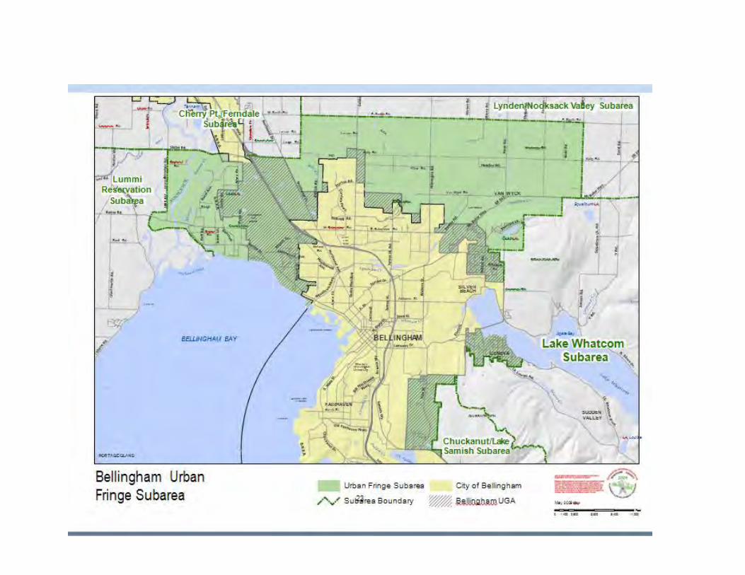
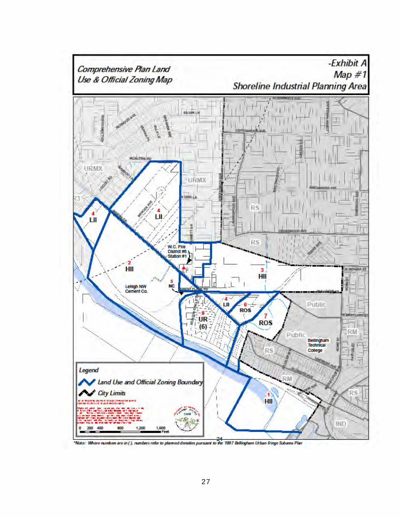
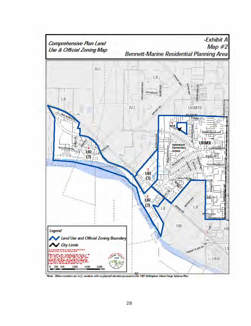
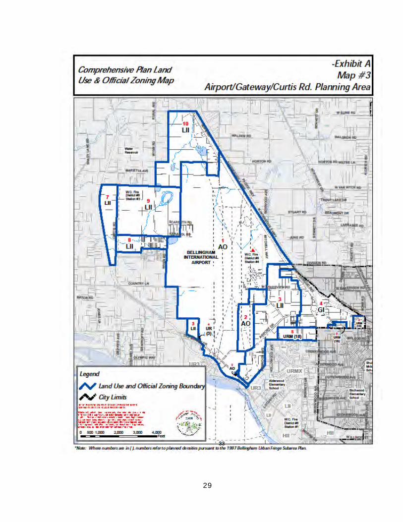
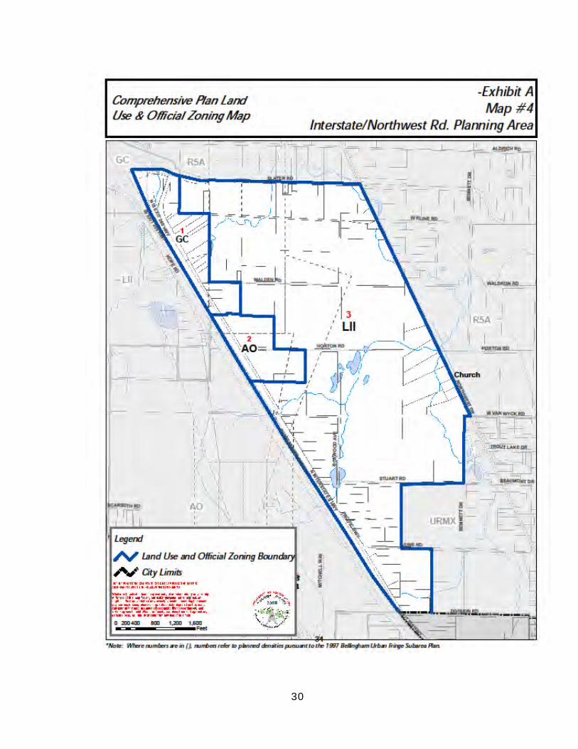
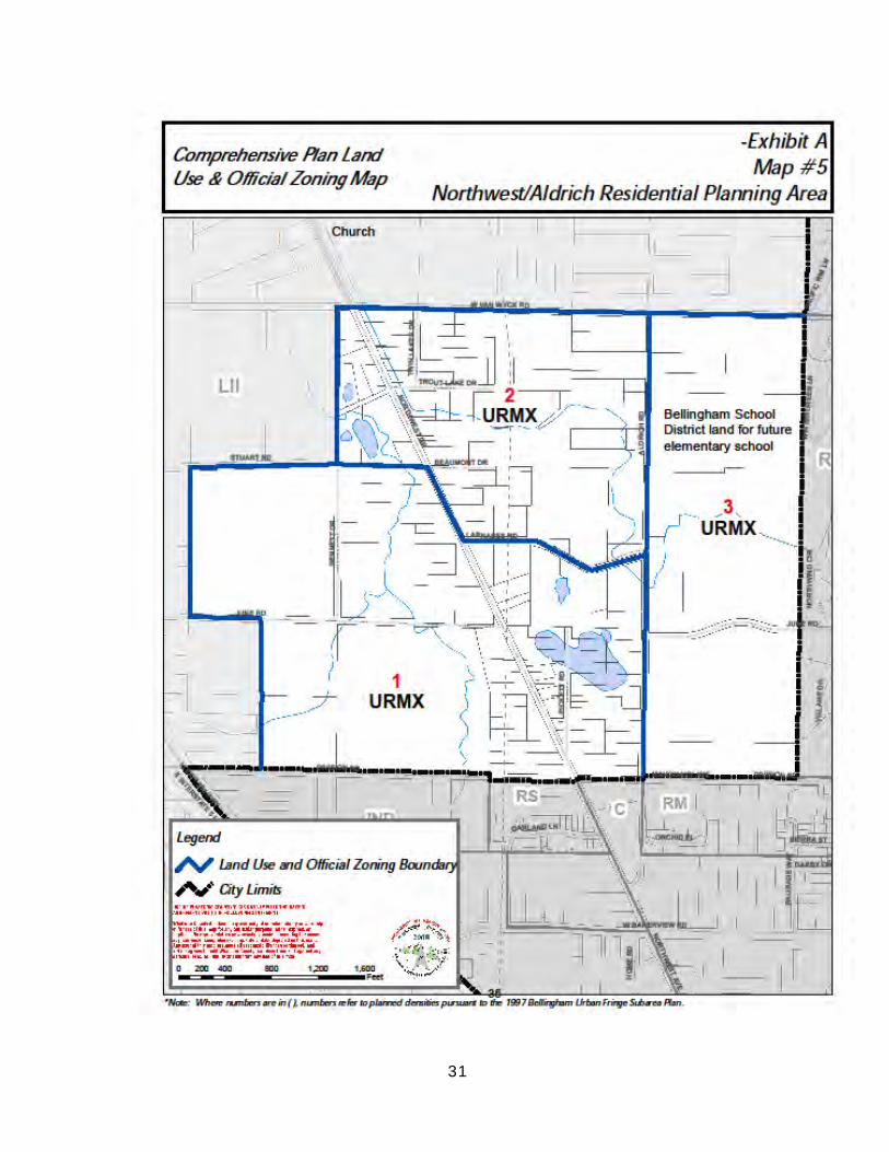
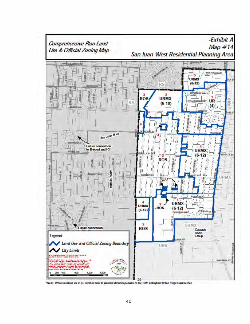
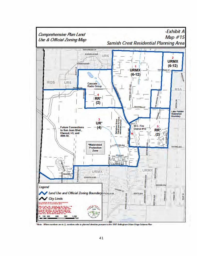
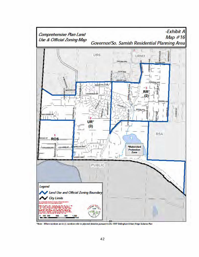
VI. Bellingham Urban Fringe Subarea Planning Area Maps
The Bellingham Urban Fringe Subarea is divided into 16 planning areas; these areas have been divided up into such planning areas based on their geographic
regions having similar features such as topography, land uses, infrastructure, service capacity, critical areas, and stream corridors. The Bellingham Subarea
planning area maps implements zoning code designations which will achieve Comprehensive Plan goals.
26
27
28
29
30
31
32
33
34
35
36
37
38
39
40
41
42
43
VII. Analysis and Rationale for Adjusting
Bellingham’s 1985 Urban Service Area Introduction
Urban Growth Areas
As required by the Washington Growth Management Act (GMA), and County-wide Planning Policies, projected population for the next 20 year
planning period must be accommodated in urban growth areas. The City of Bellingham, in cooperation with Whatcom County, is evaluating the
appropriateness of expanding or contracting its present Urban Service Area in defining an appropriate Urban Growth Area. The purpose of designating
urban growth areas is to promote compact urban development, reduce urban sprawl, and ensure efficient use of land and financing of urban facilities and services to meet the needs of the projected population during the 20 year
planning period.
The criteria for evaluating those areas outside the existing urban service area are based on an analysis and evaluation of the following:
Adopted policy and visions statements Population projections
Land supply, including residential, commercial and industrial Existing plan and zoning designations Existing land use and ownership patterns
Environmental opportunities and constraints Transportations systems
Availability and capacity of urban services and facilities and concurrency requirement
Property owners requests
Fourteen smaller areas within the three Urban Fringe Subarea Analysis
Areas have been identified and evaluated according to the criteria above for possible inclusion in Bellingham's Urban Growth Area. Map 18 shows the areas evaluated.
Marine Drive/Airport Analysis Area
Five areas have been identified in the Marine Drive/Airport Analysis Area for evaluation as possible areas for inclusion in Bellingham's Urban Growth Area. A
description of the area, zoning, and existing services and uses are provided. Advantages and disadvantages to inclusion in Bellingham's Urban Growth
Area are listed below, followed by a specific recommendation from the Bellingham City Council.
44
Area A.
This area is located west of the Urban Service Boundary, generally in the vicinity of Marine Drive and Bancroft Road, and adjacent to Bellingham Bay.
The area is zoned Rural Residential (RR1) one dwelling unit per acre. The topography is generally flat to rolling hills sloping in a southerly direction. Dense forests, pasture land, wetlands, and marshes predominate along the
Bay. The area is primarily rural in character with scattered low density single family development on larger parcels, with a pocket of residential
development approaching urban densities, primarily in the Bancroft subdivision. The Smith Garden is located south of Marine Drive and east of the Bancroft subdivision. Water District #2 and Fire District #8 serve to the area.
Advantages/Disadvantages
1. Advantages
a. Inclusion of this area would mean an increase in the land supply for residential development.
b. The Bancroft Road area is more urban in character than adjacent areas.
c. Soils have a rapid permeability and high seasonal water table and
are poor filters for septic effluent; public sewer could reduce any ground
water contamination.
2. Disadvantages
a. Much of the area is rural in character and located away from urban
development centers.
b. The Bellingham International Airport noise and clear zone acts as a barrier between the urban areas of the City and this area.
c. Urban residential densities are not appropriate abutting airports because of noise and flight paths.
d. Fire and police service constraints resulting from inadequate roadways in
the areas, the barrier created by the Bellingham International Airport.
and travel distance from existing fire facilities for extension of urban level fire protection services.
e. Increased demand on existing City facilities and services would require
new facilities and upgrading of existing facilities and services.
f. Local opposition to being part of Bellingham’s Urban Growth Area.
45
Bellingham City Council Recommendation
This area should not be included in Bellingham’s Urban Growth Area.
Area B.
The area is located west of Bellingham International Airport, north of Marine
Drive and in the general vicinity of Country Lane, Curtis and Wynn Roads. The area is zoned both Rural (R2A) one dwelling unit per two acres, and Rural
Residential (RR1) one dwelling unit per acre. The topography is generally flat. Dense forested areas, wetlands, marshes, and pasture land make up the bulk of the area. It is rural in character with scattered low density
single family development. The Burlington Northern Railroad borders the area on the southwest and the Airport separates this area from the urban
centers of the City. Water District #2 and Fire District #8 serve the area. Advantages/Disadvantages
1. Advantages
a. Inclusion of this area would mean an increase in the land supply for
residential development. b. Some property owners desire inclusion in Bellingham’s Urban Growth
Area.
c. Soils have a rapid permeability and high seasonal water table and are poor filters for septic effluent; public sewer could reduce any ground water contamination.
2. Disadvantages
a. Much of the area is rural in character and located away from urban
development centers.
b. The Bellingham International Airport acts as a barrier between the urban
areas within the City and this area.
c. Urban residential densities are not appropriate abutting airports because
of noise and flight path patterns.
d. Fire and police service constraints resulting from inadequate roadways in the area, the barrier created by the Bellingham International Airport, and travel distance from existing fire facilities for extension of urban level fire
protection services.
e. Increased demand on existing City facilities and services would require new facilities and upgrading of existing facilities and services.
46
f. Some local opposition to being part of Bellingham’s Urban Growth Area.
Bellingham City Council Recommendation
This area should not be included in Bellingham’s Urban Growth Area. Area C.
This area is located adjacent to Slater Road and across from Ferndale's
City limits. Sunset Creek is the area's southeast boundary and the Burlington Northern RR is the western boundary. The area is characterized by industrial development and is within Ferndale's proposed Urban Growth Area; it is
served by the City of Ferndale. The area is considered an anomaly since it is within the Urban Fringe Subarea and Bellingham's sphere of influence. The
area is zoned Light Impact Industrial and is approximately 19 acres. The topography is fairly flat with shrubs and bushes and some trees along the creek.
Advantages/Disadvantages
1. Advantages
a. Inclusion of this area in Bellingham’s Urban Growth Area would add to
the city’s folio of industrial land.
2. Disadvantages
a. City utilities are not available.
b. Fire and police service constraints resulting from distance from existing City facilities.
c. The area is within Ferndale’s proposed Urban Growth Area and is served
by the City of Ferndale.
d. Separation of Urban Growth Areas is required by the County-wide
Planning Policies.
Bellingham City Council Recommendation
This area should not be included in Bellingham’s Urban Growth Area.
Area D.
This area is located east of Interstate-5, adjacent to Slater Road on the south, and Pacific Highway on the east. It abuts Bellingham's Urban Service
Area boundary at the Port property on Pacific Highway. The area is approximately 30 acres and is currently zoned General Commercial. In 1989, a
47
concomitant agreement was entered into between the property owners and Whatcom County to control land uses in the vicinity of the airport and ensure
compatibility with airport activity, now and in the future.
The topography is fairly flat. Some forest-covered areas are located to the back of the lots and provide a backdrop for several businesses including a sign and custom awning shop, antique mall, auto repair shop and carpet sales and
some low density single family residential development. The area has been partially cleared for commercial development. An ARCO service station and
mobile home sales business are adjacent to Slater Road. Fire District #8 serves the area.
In 1996, this area was analyzed in Bellingham's Supplemental Environmental Impact Statement (SEIS) along with other property extending
east from this area to Northwest Drive and south from Slater Road to Stuart Road. The SEIS proposal evaluated the addition of approximately 889 acres to the City's proposed urban growth area as industrial, and to change the
proposed land designation for 139 acres from Urban Residential (UR4) to industrial. The 30 acres would remain commercial. In 1997, Bellingham City
Council recommended adding this commercial area, identified as Area #3 in the SEIS, to Bellingham's Final Urban Growth Area.
Advantages/Disadvantages
1. Advantages
a. Inclusion of this area into the City’s Urban Growth Area would enable the City to participate in the joint land use planning for the area and have greater control of development following annexation.
b. The designation is urban and recognizes existing commercial
developments.
c. The area fronts on Interstate-5 and takes access from Pacific Highway, a
major transportation corridor linking Bellingham’s northern industrial and commercial areas with other regional transportation corridors to the
north.
d. Urban development is already established in this area.
e. Joint land use planning would increase the effectiveness of interlocal
agreements made for the area.
f. There is property owner support for sewer and water services.
g. Bellingham has the capacity to serve the area with sewer and water.
48
2. Disadvantages
a. Increased demand on existing City facilities and services will require an upgrade in some existing City facilities and services.
b. City services could intensify and exacerbate a commercial strip at the
entrance to the City.
Bellingham City Council Recommendation
This area should be included in Bellingham’s Urban Growth Area.
Area E.
The area is located adjacent to Pacific Highway and east of Interstate 5. The larger portion of the area is zoned Light Impact Industrial and two smaller lots are zoned Rural (R2A). Topography is fairly flat. Some of the area is forest
covered. Several intermittent drainage channels flow through the property into Bear Creek which feeds into Silver Creek watershed. There are some
wetlands which serve as natural retention for the Silver Creek watershed. Uses include Olivine incinerator facility, Motor Trucks, a church, and CPS Allwaste.
The City provides water to Olivine. Sewer service is not provided. This area has been incorporated into the Pacific Highway North
(Industrial/Commercial) Area (Map 4b) in Bellingham's proposed Urban Growth Area. Identified as planning Area 2, this area has existing urban
development, fronts on Interstate-5, and is adjacent to Pacific Highway, a major transportation corridor linking Bellingham's northern industrial and commercial areas with urban areas further north.
Advantages/Disadvantages
1. Advantages
a. Inclusion of this area into the City’s Urban Growth Area would enable the City to participate in the joint land use planning for the area, and have
greater control of development following annexation.
b. The area is located between two sections of the Urban Service Area
Boundary (AO to the north and LII to the south).
c. Urban development is already established in the area.
d. Joint land use planning for the area would increase the effectiveness of
interlocal agreements made for the area.
e. Inclusion of this area, along with adjacent areas, would provide a more regular Urban Growth Area boundary.
49
2. Disadvantages
a. Increased demand on City facilities and services will require an upgrade in some existing City facilities and services.
Bellingham City Council Recommendation
This area should be included in Bellingham's Urban Growth Area as planning Area 2, Pacific Highway North (industrial/commercial) Area of the
Marine Drive/Airport Analysis Area. (see MAP 4B) The recommendation is based in part on: 1) public testimony at the November 24, 1996 Public Hearing on Bellingham’s Urban Growth Area; 2) analysis of Bellingham’s
industrial land supply; 3) a need for industrial zoned land in this area adjacent to three major transportation corridors; 4) proximity to Bellingham
International Airport; 5) desire of some property owners with adjacent industrially zoned land; 6) larger parcels under one ownership; and 7) the City’s SEIS analysis.
I-5/Guide Meridian Analysis Area
Four areas have been identified in the I-5/Guide Meridian Analysis Area for
evaluation as possible areas for inclusion in Bellingham's Urban Growth Area. A description of the area, zoning, and existing services and uses are provided.
Advantages and disadvantages to inclusion in Bellingham's Urban Growth Area are listed, followed by a specific recommendation from the Bellingham City Council.
Area F.
This area is located adjacent to the City's urban service area north of Bellingham in the vicinity of Northwest Avenue and Aldrich Road. Larrabee
Road forms part of its southern boundary. The area is adjacent to a portion of the Cordata Business Park PUD, scheduled for annexation to the City of
Bellingham in 1997. The area is zoned Rural (R2A) and (R5A). The topography is generally flat to rolling hills, sloping in a south westerly direction. Dense forests and wet areas associated with Bear Creek and Silver
Creek are found within the site. Characterized by single family residential development, some home occupations and small commercial businesses are
along Northwest and Aldrich Roads. Water is provided in part by individual wells and the City of Bellingham. Fire District #8 serves the area.
Advantages/Disadvantages
1. Advantages
a. Inclusion of this area into the City’s Urban Growth Area would enable the City to participate in the joint land use planning for the area.
50
b. The area is adjacent to one of the City’s rapidly urbanizing areas, and has City water.
c. Request by some property owners to be included in the City’s Urban
Growth Area.
d. Proposed extension of future Horton Road and construction of an
east/west connector will provide better circulation for this area.
e. There are some pockets of urban development already established in the area.
f. Joint land use planning for the area will increase the effectiveness of interlocal agreements made for the area.
g. Inclusion of some properties would provide a more regular boundary.
h. City ordinances and enforcement may provide greater protection of the Bear Creek corridor, Silver Creek tributaries and associated wetlands.
i. Inclusion of some property would increase the land supply for residential
development.
j. Recognition of ownership pattern would allow Foxglove Fields
development on the dry land portion of their ownership.
2. Disadvantages
a. Some property owners are opposed to inclusion in Bellingham’s Urban
Growth Area.
b. Increased demand on existing City facilities and services will require an upgrade in some City facilities and services.
Bellingham City Council Recommendation
The R2A area should be included in Bellingham's Urban Growth Area as Area 2, Northwest/Aldrich Residential Area of the I-5/Guide Meridian Analysis Area. (see MAP 8)
Area G.
This area is located north of the City, adjacent to the Urban Service Area, and is referred to for identification purposes as Cordata North. Smith
Road is its northern boundary. The area is currently zoned Rural (R10A) which allows 1 dwelling unit per ten acres. The topography ranges from fairly flat to rolling hills. The area is primarily pasture land and has been used for
commercial agricultural operations. The average parcel size is greater than ten
51
acres and existing residential density is less than or equal to one dwelling unit per ten acres. The area has wetlands associated with Bear Creek and its
tributaries which traverse and drain the site. The area is approximately 600 acres, and is presently being farmed.
Advantages/Disadvantages
1. Advantages
a. Inclusion of this area in the City’s Urban Growth Area would enable the City to participate in the joint land use planning for the area.
b. Sewer and water services could be extended to provide for development.
c. The area is under one ownership and is master planned. A development proposal exists, which if reviewed and approved would provide additional land for residential development.
d. Request by the property owner to be included in the Urban Growth Area.
2. Disadvantages
a. The area is rural in character and is presently being farmed.
b. The City of Bellingham does not have services available to this area.
c. This land is less suitable for inclusion in Bellingham’s Urban Growth Area at this time than some other areas evaluated in terms of distance to urban services and cost to provide the full range of urban services.
d. Local opposition from adjacent rural property owners and residents
to being part of Bellingham's urban growth area.
e. Increased demand on existing City facilities and services would require
new facilities and upgrading of existing facilities and services.
f. Development constraints resulting from wetland systems on the property.
g. Inclusion of this area in Bellingham’s UGA would lead to an irregular boundary.
Bellingham City Council Recommendation
This area should not be included in Bellingham's Urban Growth Area. This area should be reconsidered during the periodic review in five years.
52
Area H.
This area is located north of the City, adjacent to the Urban Service Area and includes parcels on both sides of Guide Meridian in the vicinity of Kelly Road.
The topography of the area is generally flat with some gently rolling hills. The area has both pastures and portions are forest covered. Some wetlands and tributaries are associated with Spring Creek which traverses the area. Much
of the area has been already cleared for development. The area is currently zoned Rural (R5A) allowing one dwelling unit per five acres. There are existing
home occupations, cottage industries, and other businesses operating along Guide Meridian. Water service is provided by Deer Creek Water Association. Fire District #8 serves the area west of Guide Meridian, and Fire District #4
serves the area east of Guide Meridian.
The Bellingham City Council recommends this area be included in the city's Northern Urban Growth Area based in part on: 1) public testimony at the November 25, 1996 public hearing on Bellingham's Urban growth Area; 2)
an analysis of Bellingham's vacant industrial land supply and projected demand; 3) the analysis in the city's SEIS; 4) existing mix of industrial and commercial
uses in the area; 5) proximity to one of Bellingham's rapidly growing urban areas; 6) location of the area on a major transportation corridor; and 7)
proximity to City utilities. The Expansion Area comprises approximately 242 acres, and is shown on Map 10, Guide Meridian/Mixed Use Area.
Advantages/Disadvantages
1. Advantages
a. Inclusion of this area in the City’s Urban Growth Area would enable the
City to participate in the joint land use planning for the area.
b. The area is a gateway to Bellingham from the north and is an important area of influence for the City.
c. Increasing traffic volumes and congestion generated by Bellis Fair and adjacent commercial and industrial development along Guide Meridian
has impacted this area. Because the Urban Service Boundary is irregular in this area, an opportunity exists to create a more regular boundary and limit urban sprawl and strip development patterns along Guide
Meridian.
d. The area is adjacent to one of the City’s rapidly urbanizing areas.
e. Request by some property owners to be included in the City’s Urban
Growth Area.
53
f. Proposed extension of an east/west connector would provide better circulation for this area. The City should participate in the planning of this
facility and its intersection with Guide Meridian.
g. Some urban development is already established in the area.
h. Inclusion of property designed for industrial development meets identified
need for developable industrially zoned land.
i. Joint land use planning for the area would increase the effectiveness of interlocal agreements made for the area.
j. City ordinances and enforcement may provide greater protection for Spring Creek and associated wetlands.
2. Disadvantages
a. Increased demand on existing City facilities and services would require some new facilities and upgrading of coms existing facilities and services.
Bellingham City Council Recommendation
This area should be included in Bellingham's Urban Growth Area as Area 2, Guide Meridian Mixed Use Area of the I-5/Guide Meridian Analysis Area. (See
Map 10).
Area I. This area is located northeast of the City, adjacent to the Urban Service Area,
extending approximately 1700 feet east of Guide Meridian. Access to the existing dwelling units is off Guide Meridian at Kellogg and East Bakerview
Road. The topography of the area is generally flat to rolling hills with slopes up to 15 percent. The area is generally rural in character with scattered single family residential development. The Calvary Temple Church property is located
in this area. The area has both pasture and dense forested areas associated with the Spring Creek corridor. Spring Creek traverses part of the area and
drains the area to the southwest. The area is currently zoned Rural (R5A) allowing one dwelling unit to five acres, and comprises approximately 229 acres.
This area includes the existing platted residential lots off of James Street north of East Bakerview Road, including Gooding Avenue, Frances, Avenue, King
Avenue, and Montgomery Road know as King Mountain. The area also includes the area west of James Street to the Calvary Temple property. The area provides a forested backdrop for the City of Bellingham and view lots for
residential development. The area is currently zoned RR2 and R5A. The terrain is hilly with some slopes ranging from 15% to 40%+ in the northeastern
portion of King Mountain. The extension of Kellogg Road through this area has been identified as a needed improvement to link Bellingham's regional
54
retail/commercial area with James Street and areas east. The City of Bellingham took over former Water District #9 and currently provides water to
the area. Fire District #4 serves the area. A fire station is located at the southwest corner of James Street and East Bakerview Road.
This expansion area has been enlarged to include property at the crest of King Mountain, and property east of James Street and north of East Bakerview Road,
based in part on: 1) analysis of Bellingham's land supply; 2) existing urban residential development in the area; 3) existing utilities; 4) a need to improve
transportation circulation in the area, and 5) desire for a more even and logical Urban Growth Area.
Advantages/Disadvantages
1. Advantages
a. The area is within Bellingham’s sphere of influence and adjoins a rapidly
growing commercial, industrial and high density residential area of the City. Increasing traffic volumes and congestion generated by Bellis Fair
and adjacent commercial and industrial development along Guide Meridian impacts this area.
b. Request by some property owners to be included in the City’s Urban
Growth Area.
c. Proposed extension of Kellogg Road to James Street would provide better
circulation for the area and larger vicinity, and would be partially provided by the Calvary Temple Church.
d. The area has pockets of urban development close to employment centers at Kellogg Road, Meridian Street, and Bakerview/Hannegan industrial.
e. Inclusion would provide a more regular boundary.
f. City ordinances and enforcement may provide greater protection for the Spring Creek and associated wetlands and environmentally sensitive
areas.
g. An opportunity exists to provide park land and open space between two
developed areas.
h. Water is provided by the City of Bellingham.
i. Joint land use planning for the area would increase the effectiveness of
interlocal agreements made for the area.
j. Request by some property owners to be included in the City’s Urban Growth Area.
55
2. Disadvantages
a. Increased demand on existing City facilities and services would require some new facilities and upgrading of some existing facilities and services.
Bellingham City Council Recommendation
This area should be included in Bellingham's Urban Growth Area as Area 1, King Mountain Residential Area which is situated in both the I-5/Guide
Meridian and Squalicum Creek Analysis Areas. (see MAP 12).
Squalicum Creek Analysis Area
Five areas have been identified in the Squalicum Creek Analysis Area for
evaluation as possible areas for inclusion in Bellingham's Urban Growth Area. A description of the area, zoning, and existing services and uses are
provided. Advantages and disadvantages to inclusion in Bellingham's Urban Growth Area are listed, followed by a specific recommendation.
Area J.
This area is located on both sides of Hannegan Road north of the existing Urban Service Area boundary in the vicinity of the Mount Baker Motor Cycle Club. The terrain is generally flat adjacent to Hannegan Road and has
been cleared. Baker Creek traverses the area. Queen Mountain lies to the northwest of the area. The area is currently zoned R5A. The East
Bakerview/Hannegan Industrial site is to the south of this area and is zoned for general manufacturing and light impact industrial uses.
Bellingham City Council is recommending inclusion of this area in the city's Northern Urban Growth Area based in part on: 1) public testimony at the
November 24, 1996 public hearing on Bellingham's Urban growth Area; 2) an analysis of Bellingham's industrial land supply; 3) an analysis of this
area in the city's SEIS; 4) proximity to existing industrially zoned areas and development in the adjacent area; 5) location of the area on two major transportation corridors (ie. Hannegan and Bakerview Roads); and 6)
proximity to City utilities. The Expansion Area comprises approximately 200 acres, and is identified as Area 5, on Map 14, Bakerview/Hannegan
Industrial Area. Advantages/Disadvantages
1. Advantages
a. Inclusion of this area in the City's Urban Growth Area would enable the
City to participate in the joint land use planning for the area.
56
b. Joint land use planning for the area would increase the effectiveness of interlocal agreements made for the area.
c. This area could provide additional land for industrial development and
expansion of adjacent industrial uses.
d. Existing urban development in the area.
e. Request by some property owners to be included in the Urban Growth Area.
f. City ordinances and enforcement may provide greater protection for the
Spring Creek and associated wetlands and environmentally sensitive areas.
2. Disadvantages
a. Increased demand on existing City facilities and services would require
some new facilities and upgrading of some existing facilities and services.
b. Inclusion of properties adjacent to Hannegan would create a somewhat
irregular Urban Growth Area Boundary.
Bellingham City Council Recommendation This area should be included in Bellingham’s Urban Growth at this time.
Area L.
This area is located north of Dewey Valley Road and within the Urban Service Area. The terrain is generally flat along Mount Baker Highway, but
drops off with slopes ranging from 0 to 15% toward the northwest. Pastures, forested areas, and some wetlands are associated with Squalicum
Creek tributaries and Toad Creek. The area is generally rural in the valley with low density single family development. Some of the area is urban in character adjacent to the ridge along Mount Baker Highway.
Questions have been raised regarding the appropriateness of keeping the
Dewey Valley in Bellingham's Urban Growth Area. There are some advantages for retaining this area in Bellingham's Urban Growth Area and some disadvantages. Two options are recommended for consideration.
Advantages/Disadvantages
1. Advantages
a. Inclusion of this area in the City’s Urban Growth Area would enable the City to continue to participate in the joint land use planning for the area.
57
b. Joint land use planning for the area would increase the effectiveness of interlocal agreements made for the area.
c. Some areas are characterized by urban development along Mount
Baker Highway and are close to employment centers at Bakerview/Hannegan industrial and Sunset Mall.
d. The area provides an opportunity for open space planning.
e. Water is provided by the City of Bellingham along Mount Baker Highway.
f. Exclusion of this area would provide more support for adding other
areas that are more suitable for urban development and easier to serve.
2. Disadvantages
a. Urban development would be inconsistent with existing rural pattern
of development and character of the area.
b. Increased demand on existing City facilities and services would require an upgrade in some existing City facilities and services.
Bellingham City Council Recommendation
Retain the area in Bellingham's Urban Growth Area at the existing zoning designation and density, and provide development standards to protect the
sensitive environmental areas in the valley, including requiring clustering and setbacks from creeks.
Area M.
This area is located at the intersection of Mount Baker Highway and Britton Road in the vicinity of the BPA transmission lines. This area is approximately 18 acres and is zoned Rural 5A. Much of the area has been cleared and some
commercial, industrial and non-conforming development exists.
Advantages/Disadvantages 1. Advantages
a. Inclusion of the entire intersection of Mount Baker Highway and Britton
Road in the Urban Growth Area and the rezone to Neighborhood Commercial would allow the City to participate in the joint planning of the area.
b. It may be appropriate to recognize existing development in the area
through inclusion of the area in Bellingham’s Northern Urban Growth Area.
58
c. The area may be appropriate for a neighborhood commercial
development to serve a growing residential area and high school population.
d. Joint land use planning for the area would increase the effectiveness of
interlocal agreements made for the area.
e. Water is provided by the City of Bellingham along Mount Baker Highway.
f. Request by some property owners to be included in Bellingham’s Urban
Growth Area as commercial.
2. Disadvantages
a. Increased demand on existing City facilities and services will require an
upgrade in some existing City facilities and services.
b. Increased traffic impacts at the intersection of Mount Baker Highway and
Britton Road.
Bellingham City Council Recommendation
This area should be included in the Urban Growth Area as Area 1, Britton/Baker Residential Area of the Squalicum Creek Analysis Area. (See
Map 16)
Area N.
This area is located northeast of the Urban Service Area boundary in the vicinity of Emerald (Toad) Lake. Toad Lake is situated on the northwest slope of Squalicum Mountain and has grades of 45%. The area is
characterized by steep slopes facing west and ranging from 15% to over 40%. Much of the area is densely forested. About 200 acres in the westerly
portion of this area are accessed from Emerald Lake Road at Britton Road. The southeastern portion of the area is accessed from Toad Lake Road. Toad Lake Creek drains the area. Low density single family residential development
characterizes this area, with a mix of vacation cabins, mobile homes and what appears to be assorted non-conforming structures in the immediate vicinity of
the lake. Soils are generally not suitable for septic systems. As part of the Bellingham's 1994 Final Environmental Impact Statement on
the City's 20-year growth alternatives, this area was evaluated for possible inclusion in Bellingham's Northern Urban Growth Area. Because of its steep
slopes, narrow winding roads, and access constraints for fire and police protection vehicles, the City Council's recommendation is to leave this area in the county and not include it in Bellingham's Urban Growth Area.
Development capacity of the area does not support the cost of new facilities
59
and services.
Advantages/Disadvantages
1. Advantages
a. Inclusion of this area in the City’s Urban Growth Area would enable the
City to participate in the joint land use planning for the area.
b. Joint land use planning for the area would increase the effectiveness of interlocal agreements made for the area.
c. The area provides an opportunity for open space planning.
2. Disadvantages
a. Urban development would be inconsistent with existing rural pattern of
development and character of the area.
b. Increased demand on existing City facilities and services will require an upgrade in some existing City facilities and services. Development
capacity of the area does not support the cost of new facilities and services.
c. Development is separated by terrain from major urban development centers.
d. Growth is not anticipated to occur in this area.
e. Fire and police service constraints resulting from inadequate facilities, distances from existing facilities and roadways in the area.
Bellingham City Council Recommendation
This area should be included in Bellingham’s Five Year Review.
VIII. Five Year Periodic Review
60
In order to assure sufficient flexibility in Bellingham’s Northern Urban Growth Area, and to respond to land supply and demand changes, the City and
Whatcom County should review certain areas identified in this plan on a priority basis. At such time that a need for more land is justified by updated
land supply, demand studies, and other planning criteria, including: changed conditions, availability and capacity of urban services, including sewer, water, and other infrastructure, transportation systems, land use and ownership
patterns, property owner requests, environmental opportunities, and others, these areas would be considered.
Four areas have been identified for consideration during Bellingham’s Five Year Periodic Review. These areas, shown on Map 19, have a number of factors in
common, including:
These areas are adjacent to the existing Urban Service Area and recommended Urban Growth Area.
These areas are within a larger urbanizing area or influence area.
Environmental opportunities may exist for park and trail development.
Some of these areas already have City water.
Some of the property owners have requested to be included in the Urban
Growth Area or to be zoned for urban development.
Conditions around these areas may change during the next five years in such a way as to contribute to their potential designations within Bellingham’s Urban Growth Area.
These areas have the capacity for logical expansion of existing or similar
neighboring land uses.
IX. Comprehensive Plan Amendments
61
The Urban Fringe Subarea Plan is a policy document that is used to guide the land use decisions affecting both the private and public sectors of the
subarea. For the plan to function as an effective decision-making document, it must be flexible enough to weather changes in public attitudes, developmental
technologies, economic forces and legislative policy. The plan envisions two general types of plan amendments. The first type is
a review conducted every five years. This Periodic Review should re-examine the land use plan, including a re-evaluation of goals; updates of
land-related elements; the reaffirmation of land use policies, proposals, and neighborhood planning areas within Bellingham's Urban Growth Area; land supply and demand analysis; and consideration of urban development needs.
It is the responsibility of both the Bellingham and Whatcom County Planning Commissions and Planning staff as well as the people of the subarea to initiate
and participate in such a review. To assure sufficient flexibility in the urban growth area and to respond to
land supply and demand changes, the City of Bellingham and Whatcom County shall review certain areas identified in this plan on a priority basis. These
"priority areas" shall receive first consideration for inclusion in Bellingham's Urban Growth Area when a need for more land is justified by updated land
supply and demand studies. The second type of amendment is that proposed and initiated by
private property owners. The land uses illustrated on the Land Use Plan Map are the result of the application of the plan's goals and policies.
However, it is reasonable to assume that private property owners may introduce land use proposals that conflict with the plan map or policies of the plan itself. In such instances, an individual or agency may propose an
amendment to the plan. Private petitions for amendment of the Comprehensive Plan addressed to either the Whatcom County Planning
Commission or the County Council shall be processed in accordance with the statutory procedure for adoption or amendment of comprehensive plans. Plan amendments initiated by either the public or private sector which alter or
expand the Urban Growth Area for the City of Bellingham shall be jointly processed by Bellingham and Whatcom County Planning Departments,
Planning Commissions, and Councils. Individual applications for Comprehensive Plan amendments, rezones, and
zoning text amendments shall be made in writing in accordance with forms supplied by Whatcom County. Applications shall be accompanied by an
Environmental Checklist pursuant to the Washington State Environmental Policy Act (SEPA) and Whatcom County SEPA rules; appropriate fees as specified in the Whatcom County Fee Ordinance; maps and property
information as specified on the application forms; and the names and addresses of the owners of property within 300 feet of the proposed
amendment.
62
The steps in processing an amendment are: 1. schedule a Planning Commission public hearing; 2. publish legal notice in local newspaper at least
10 days before the hearing, mail notice to surrounding property owners, and post notice on the property at least 12 days before the hearing; 3. Planning
staff report and recommendation to Planning Commission, approximately one week before the hearing; 3. Planning Commission public hearing; 4. Planning Commission recommendation forwarded to County Council; and 5.
final Council action.
All proposed amendments to the plan or plan map and implementing zoning maps and regulations shall conform to the following criteria:
1. The amendment request shall conform with applicable Washington State laws governing Comprehensive Plan amendments.
2. The amendment request shall conform with the goals of the subarea plan.
3. The amendment request shall be consistent with the polices of this plan, the County-wide Planning Polices and the polices of the other elements
and components of the Whatcom County Comprehensive Plan.
4. The amendment request shall be compatible with the existing and planned surrounding land uses.
5. The amendment request shall not result in unmitigated detrimental impacts to existing transportation systems.
6. The amendment request shall not place uncompensated burdens upon
existing or planned service capabilities.
7. The amendment request shall demonstrate a land use need which is
currently not met by this plan.
8. The proponents of a rezone have the burden of proving that conditions
supporting the existing zoning have substantially changed since the original zoning or most recent amendment; or that there was an error of
fact made in the existing zoning designation.
9. A proposed rezone must bear a substantial relationship to the general
welfare of the community.
10. A site specific rezone that grants a discriminatory benefit to one group to the detriment of its neighbors or community at large must provide sufficient public advantage to outweigh said detriment.
X. Implementation and Action Plan
63
The policies in this Plan implemented by the recommended zoning are intended to work toward consistency with achieving county-wide land use planning
goals and the particular issues which surfaced during the planning process for the Urban Fringe Subarea. Some of the policies, however, need to be
implemented by other means if the area is to develop in the manner desired. Also, there are some processes under way which will not be completed before the update of this plan. This Action Plan provides an opportunity to respond to
the results of those processes without the necessity to completely revise the comprehensive plan. For example, the Guide Meridian corridor is presently
under study. The results of that study may indicate the need for some changes in the Guide Meridian Improvement Plan and a need for design standards and performance driven zoning along some parts of the Guide in the
Subarea.
This section proposes activities which should be pursued by the public and private sectors no later than two years following the adoption of this comprehensive plan update.
1. Re-Negotiate and Update the Interlocal Agreement Between
Bellingham and Whatcom County
Following the 1984 adoption of the Urban Fringe Subarea Comprehensive Plan, Bellingham and Whatcom County entered into an interlocal agreement in 1985. This was a constructive move toward addressing issues of timing and
requirements for urban service and annexation in the designated Urban Reserve area as well as intergovernmental coordination in processing
development permits. As part of the requirement for interlocal cooperation established in the Washington State Growth Management Act, Whatcom County anticipates adoption of general interlocal agreements between the
County and the incorporated cities prior to adoption of this plan update. Any needed fine tuning revisions should be undertaken within one year after
adoption of the plan. The revised Interlocal Agreement will address such issues as balancing City and County revenues and expenditures when considering annexations, dealing with impacts of annexations on special district
governments, coordinating city/county development and design standards for projects that will be processed without requiring annexation and the timing and
phasing of future annexations. 2. Design Standards
An issue that keeps coming up in the Urban Fringe Subarea is the lack of
development design standards that deal with the appearance of commercial and industrial areas. The Guide Meridian corridor is a highly visible entrance to both Whatcom County and Bellingham and as such has a responsibility for
creating a favorable first impression of our community. Consideration should be given to creating a design overlay district in this and possibly other
areas where appearance is of importance to the economic vitality and future livability of the community.
64
3. Guide Meridian Improvement Plan
The Guide Meridian Improvement Plan was adopted in 1985 and is both
a component of the Urban Fringe Subarea Comprehensive Plan and a land use regulation for a special district. Its purpose is to assure that traffic concerns are adequately considered as development occurs in this corridor and
as the State of Washington continues its program of upgrading this State highway. The plan originally applied to an area approximately one-eighth
mile wide between the Bellingham City Limits and approximately one-eighth mile north of Horton Road. The need for updating this document stems from several sources. The City of Bellingham has annexed most of the affected
area on the west side of Guide Meridian. Implementation of the Plan on a site by site basis has been inconsistent, varying with County permit
administration staff. Also, development has proceeded at an accelerated pace in this area and traffic safety and congestion continue to be concerns. The Plan originally projected certain traffic volumes for the corridor to the year
1995. The traffic volume projected for 1995 was actually exceeded in 1992. The Whatcom county Council of Governments is presently coordinating a land
use and access study of the Guide Meridian corridor in conjunction with Bellingham, Whatcom County and the Washington State Department of
Transportation. Recommendations concerning future land use and access should be incorporated into any update of the Guide Meridian Improvement Plan.
4. Creative Development Techniques
There are various alternatives for development regulations that have not been fully utilized by Whatcom County or Bellingham. These alternatives are
generally intended to provide greater flexibility in land use than conventional zoning while at the same time preserving property rights, speeding up the
permitting process, assuring environmental protection, and maintaining a liveable community. Creative techniques include such things as residential cluster options, planned unit developments, special area plans, performance
zoning, and transferable development rights. In order to fully address the land use issues affecting the subarea and to fully implement the
comprehensive plan, consideration needs to be given to using some or all of these techniques.
5. Plan Revisions in Response to the Whatcom County Comprehensive Plan Process and the Designation of Urban
Growth Areas
As the Whatcom County Comprehensive Plan process is completed, revisions
to the policies and designations in the portion of the subarea designated for rural and agricultural land uses may be indicated. Also, the subarea plan may need to be adjusted to reflect the designation of urban growth areas.

65