Embed Size (px)
Citation preview
'
Report to the
Northwest Pipeline Corporation
Salt Lake City, Utah
A PRELIMINARY ENVIRONMENTAL ASSESSMENT
OF THE TAYLOR HIGHHAY, ALASKA,
HITH REFERENCE TO A NATURAL GAS PIPELINE
by
Ja~k M. Van Hyning, Ph.D.
Biological Consultant
P. 0. Box 80165
Fairbanks, Alaska 99708
August 1977
'
•
•
•
•
TABLE OF CONTENTS
INTRODUCTION •••.•••••.•••••••••.••••••.•.•••••••••••••••••
DESCRIPTION OF THE ENVIRONMENT. ••••••..•••••••••••••••.•••
Page
1
3
General TopographY, Climate and Vegatation.......... 3
Population and Economy.............................. 5
The Fortymile River................................ 7
Fish .................................... · ........ :... 14
Wildlife ..................•......................... 16
LOG OF THE TAYLOR HIGHWAY................................. 22
SUMMARY AND CONCLUSIONS................................... 29·
REFERENCES •..•.•.••. ; • • . • . • • • • • . • • • . . • . • . • • • • • • . • . • • • . . • • • 33-
•
•
•
INTRODUCTION
The Canadian National Energy Board proposed in early July 1977
that the Alcan natural gas line route paralleling the Alaska Highway
be modified to swing north to Dawson City, Yukon Territory, where it
would be available to transport gas reserves from the Mackenzie River
Delta via a future spur line along the Demster Highway.
Such a reroute would depart from the Alaska Highway at Tetlin
Junction, approximately 80 miles from the U.S. - Canadian border, and
would proceed north along the Taylor Highway for 109 miles to the bor
der near Boundary and then 68 additional miles to Dawson City before
turning southeast along the Klondike Highway to again join the Alaska
Highway near Whitehorse. While such an alternative route had been
previously suggested, it had not been formally proposed and there was
little defination of possible environmental impacts. Considerable in
formation does exist on the environment and natural resources adjacent
to the Taylor Highway, but the material had not been brought together
in a format applicable to pipeline construction and maintenance.
The purpose of this preliminary investigation is to summarize the
available literature, interview agency personnel familiar with the Taylor
Highway and the Fortymile River basin through which it passes and to
conduct a brief field survey to become personally familiar with the
area and to define possible environmental problems and subject areas
that may require further detailed study. Emphasis has been placed on
fish and wildlife and aquatic ecosystems, the writer's field of exper
tese, but notes have been included as to other possible environmental
1
•
•
and engineering aspects, subject to further consideration by experts
in other disciplines.
The field reconnasissance was conducted by vehicle along the Tay
lor Highway during the period 3 - 5 August 1977. Time preceding and
following that period was devoted to gathering information, data syn
thesis and writing. Observations were made of: the general terrain;
stream charactistics including productivity, turbidity, water temper
ature in degrees Fahrenheit, flow as a cubic feet per second (cfs)
order of magnitude "guesstimate" to give some impression of size; rec
reational and commercial utilization; and potential pipeline construc
tion environmental problems. Photographs of the major stream crossings
were taken. No observations were made at this time of conditions any
distance from the highway· or of water bodies which would not appear
to be directly impacted by the proposed pipeline, which is assumed
would closely follow the road. Distances refer to miles from Tetlin
Junction as given by Alaska State Department of Highways (DOH), 1977.
The weather had been unseasonably hot and dry prior to and during the
survey and the streams were probably below their usual late summer low
levels. Undoubtedly a number of smaller tributaries that might ordin
arily contain flowing water were dry or reduced to seepage .
2
DESCRIPTION OF THE ENVIRONt1ENT
General Topography, Climate and Vegetation
The Taylor Highway lies approximately 180 miles east of Fairbanks
in the area referred to as Interior Alaska, a region characterized by
alternating rounded even-topped ridges with gentle side slopes inter
spersed with wide flat river valleys. This area of rolling hills and
valleys, with the occasional mountain that may range up to 6,000 feet
in elevation, has been termed the Northern Plateau or Yukon-Tanana Up
land Physiographic Province. Along the Taylor Highway elevations range
from 1,540 feet at the South Fork to over 3,500 feet near Mount Fairplay
and 4,150 feet at the Canadian border. Bedrock is exposed in some river
canyons and ridges, but most of the terrain is mantled with vegetation
or surface rubble. The area is heavily mineralized. The Tintina Fault
or Trench lies near the Yukon River some 45 miles north of the proposed
alternate pipeline route. No glacial activity exists in the region at
the present time and the streams do not present the silty, braided con
dition typical of glacial rivers. The Fortymile River and its major
tributaries flow in broad, alluvial "U-shaped" basins with narrow flood
plains. Marshes and bogs are numerous, but few lakes occur in the drain
age.
Predominant soils consist of glacial till and outwash sands and
gravels with wet loams and thick organic mats often underlying lowland
areas. Well drained, brown, loamy soils overlay gravel and sand in
terraces and low hills; loess deposits on high hills may be extensive.
Moderate to high potential for erosian is common in all soil types in
the region. Discontinuous p:rmafrost is widespread·throu9hout_the area
3
along ·with ice wedges. Combined with soils of high erosion capability,
the discontinuous permafrost at a temperature of 30 - 32°F results in
very unstable earth material subject to thermal degradation and erosion
when the insulating vegetation mat is disturbed. In most areas a dense:
ground cover of grasses, mosses and shrubs retards run-off. Ground
water supplies appear limited in availability. DOH (1977) contains
considerable detailed information on the geology and soils of the area
in reference to road upgrading much of which would also be applicable
to pipeline construction.
The region experiences a typical, subarctic continental climate
long, cold winters and short, warm summers. Freeze-up of the rivers
occurs in October and they become ice-free in early to mid~May in most
years. Most of the annual precipitation occurs as summer thunderstorms,
and averages only 11 inches per year. Snowfall averages 45 inches and
snow is generally present from October to April.
Most of the Taylor Highway traverses upland spruce-hardwood forests,
but with considerable areas of high brush thickets and some low brush
muskeg-bog and alpine tundra. Large forest fires have changed the
vegetation in many areas and the landscape shows various stages of
succession. Quacking aspen, paper birch and white spruce forests with
an understory of willows, rose, alders, buffaloberry and cranberry cover
most of the upland areas. Black spruce predominates in the poorly
drained lowlands associated with tamarack, various hardwoods, mosses,
sedges and grasses. Muskey bogs are found where conditions are too
wet for tree growth. High brush thickets of birch, alder and willow
cover extensive areas below the tundra. Alpine tundra occurs above
the 2,500 foot level and consists of bare rock and rubble interspersed
4
with h·erbacious plants including willow, dwarf birch, bearberry, mountain
avens, blueberry and cranberry as well as sedges and grasses. Some sage-•
brush grows on the dry slopes. No threatened of endangered plant species
are known to inhabit the area.
Population and Economy
The only communities on the Taylor Highway beb1een Tetlin Junction
and the border are Chicken and Boundary. Census data are conflicting,
but the summer population of Chicken may be 100-150, while less than
10 spend the winter there and could thus be termed permanent residents.
Boundary also has a population of about 10. A number of people also
summer at Jack Wade, Highway Department camps and at mining operations,
but the permanent population is probably less than 20, (U. S. Department
of the Interior (DO!), 1973). The fact that the road is not kept open
in winter probably accounts in large part for the sparse population.
There are no public utilities, no schools, and no churches.
The Taylor Highway was built in the early 1950's to aid the
mining industry, but tourism has overtaken mining as the main user
group. Considerable mining activity still exists in the Fortymile
Country, and it may well expand in the future, but much of the present-
day placer gold mining appears to be of a semi-recreational or hobby
nature, (Schetzl"e; 1976). To date gold has been the only mineral of
economic significance. There is much interest in developing a latent
asbestos resource, as well as copper and other minerals, but production
awaits further assessment, improved economic conditions and settlement
of the complex land ownership issues. Timber is not presently utilized
commercially, but in the early mining days great quantities were used
for construction, thawing gravel beds in the gold fields and as fuel
5
for dredges and steam boats. One gold dredge used 12 cords of v1ood per
day or 1,500 cords annually.
Tourist interest is directed in large part towards history, mining
and the gold rush rather than the more usual fishing, hunting and scenic
attractions so the two industries, in this instance, seem compatible.
Fishing, by most Alaskan standards, could only be classed as mediocre;
hunting along the Taylor Highway has become minimal, due to the decline
in big game populations; and the scenery, while pleasant, is not
spectacular. Due to the lack of accommodations, nearly all the tourists
are campers, and thus contribute relatively little to the economy of
the area. A few tour ·buses take the Klondike Loop, viewing the at
tractions of Dawson City and the Taylor Highway. About 125 vehicles per·
day used the road in 1975. The term "highway" is somewhat a misnomer
as the road surface is in rather poor condition; alternately dusty or
muddy; narrow - average width of 21 feet with no shoulders; and with
sharp horizontal and vertical curves. While adequate for slow moving,
light tourist traffic, it would barely suffice as a haul road for heavy
equipment although at times the road has served as a haul route for
asbestos ore trucked from the mine at Clinton. Creek. i.n the Yukon Territory
to the railhead at Fairbanks. The state has plans for upgrading the
highway and is presently replacing most of the single"lane bridges,
(DOH, 1977). With both American and Canadian upgrading and tourist
promotion, the Taylor could become a primary Alaska entry route with
greatly increased traffic and tourist-related activities. The proposed
Wild and Scenic River status for the Fortymile will also increase
tourist interest. The DOI (1973) estimates that the annual rate of
recreation use will increase from the present 36,000 visitor days per
season to 119,000 with implementation of the proposal. The Fortymile
6
River· area is becoming increasingly popular for recreational pursuits
and future development must maintain a compatability with these values . •
In a DOH (1977) survey, 66% of the respondents said that they had camped,
42% panned for gold, 37% engaged in photography, 29% fished, 21% hiked
with lesser percentages in various other outdoor activities. Thus
there is a matrix of rounded outdoor utilization, with no one outstanding
value for most of the visitors.
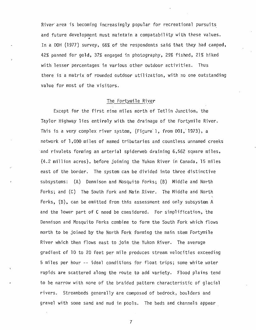
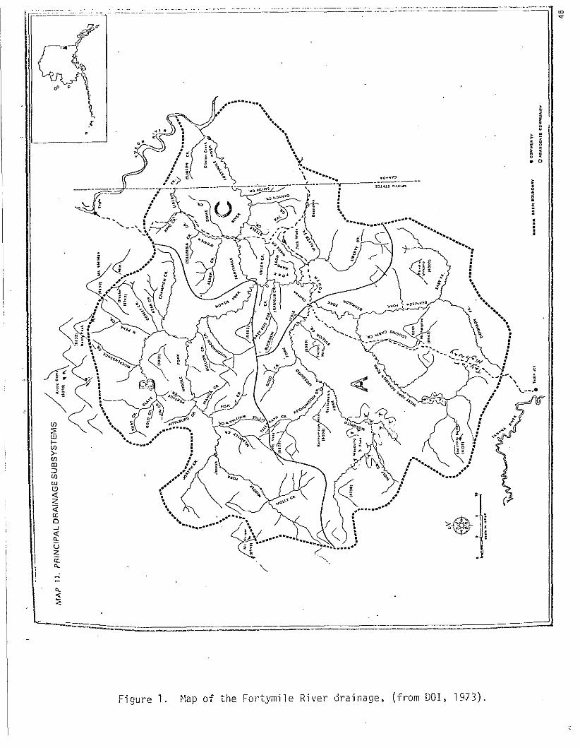
The Fortymile River
Except for the first nine miles north of Tetlin Junction, the
Taylor Highway lies entirely with the drainage of the Fortymile River.
This is a very complex river system, (Fiourel, from DOI,'T973), a
network of 1,000 miles of named tributaries and countless unnamed creeks
and rivulets forming an arterial spiderweb draining 6,562 square miles,
(4.2 million acres), before joining the Yukon River in Canada, 15 miles
east of the border. The system can be divided into three distinctive
subsystems: (A) Dennison and Mosquito Forks; (B) Middle and North
Forks; and (C) The South Fork and Matn .River. The Middle a~d North
Forks, {B), can be omitted from this assessment and only subsystem A
and the lower part of C need be considered. For simplification, the
Dennison and Mosquito Forks combine to form the South Fork which flows
north to be joined by the North Fork forming the main stem Fortymile
River which then flows east to join the Yukon River. The average
gradient of 10 to 20 feet per mile produces stream velocities exceeding
5 miles per hour -- ideal conditions for float trips; some white water
rapids are scattered along the route to add variety. Flood plains tend
to be narrow with none of the braided pattern characteristic of glacial
rivers. Streambeds generally are composed of bedrock, boulders and
gravel with some sand and mud in pools. The beds and channels appear
7
fairly stable as well as the bank vegetation. Except where mining
has disturbed the substrate, notably in the Chicken and \>Jade Creek areas,
there is little surface evidence of extensive gravel deposits although
muskeg covered terraces - remnants of ancient drainage~- occur in
many places and generally consist of course gravel overlying bed rock.
There is little information on stream flow in the Fortymile Basin.
Maximum flow occurs in late J,1ay or early June following snow melt and
spring breakup. Rain induced high water can be expected at any time
during the summer. Low flows start in August and flow continues to
drop throughout the fall months and into winter when surface water
becomes locked up as ice. Some water data were collected during the
summer months of 1910-12 by the U.S. Geological Survey, (USGS, 1957),
for determination of availability for mining. The tftosquito Fork had
a maximum flow of 4,030 cfs on June 16, 1912 and a minimum of 34 cfs
on September 30, 191 0. Monthly mean discharges in cfs were:
June July August September
1910 190 95 60 1911 172 1912 1 '673 210 292 459
The Dennison Fork during June and July of 1912 had a maximum discharge
of 6,500 Cfs and a minimum of 105 cfs. The Walker Fork in July and
August of 1910 had a maximum discharge of 242 cfs and a minimum of 9.
For the South Fork mean discharges in cfs were:
r~ay June ~ Auaust September
191 0 889 911 485 1911 970 932 336 345 1912 2,280 5,340 635 1 ,380 1 '140
Maximum discharge during this period was 12,600 cfs on June 17, 1912
and the minimum was 1J4 on August 6, 1910.
8
During July of 1954 and 1955 the USGS made a few spot checks,
(USGS, 1958): ~1osquito Fork ranged from 260 to 1,070 cfs; the Vlest •
Fork of Dennison Fork from 114 to 395 cfs and the South Fork from 621 ·: ,'
to 1,600 cfs. In more recent times the USGS has operated a gaging
station near Steele Creek on the main Fortymile River, (J~r. Robert
Borrows, USGS, Fairbanks, pers. comm., 1977). For the 1976 water
year, maximum flow was on i'1ay 3-4 at 23,000 cfs, average discharges
were 0 in ~1arch; 38 cfs in April; 10,139 in ~1ay; 4,000 cfs in June;
1,800 in July; 1,700 in August; 940 cfs in September; 588 cfs in
October, declining to 1 cfs in November and to 0 flow in December.
There is little mention of serious floods in the Fortymile drainage;
Selkregg, (1977), lists a flood stage at Steele Creek of 42,800 cfs
on July ll, 1963.
There are no USGS water quality monitoring stations on the Forty
mile River, but occasional spot samples have been taken and published
in USGS Hater Supply Papers. The streams receive natural sediment
principally during sno1~ melt and rainstorm runoff; about 50% of the
annual sediment load is transported during the period of spring runoff.
Except for seasonal sedimentation from the spring snow melt, some placer
mining activity, and varying degrees of brownish discoloration from
organic material picked up from the muskeg bogs which they drain, the
water is clear and quality is considered good. The Bureau of Land
Management, (BLM, 1976), notes that siltation in the South Fork has
increased during recent years and is beyond limits set by the Environ-
mental Protection Agency, (EPA). Also, new mining roads and heavy use
by all-terrain vehicles are causing damage to fragile soils and erosion.
The U. S. Department of the Interior, (DOI, 1973), has recommended
9
~ ,(1"1~•'-'"G .................
• • • • • • • : .... ~ ••• ......
• <#·· f' •• •• • • ~ ...
........................ <#···~··;· ...... I ......... . ... ..
~-----~=~~--------·-
.................... ........ ..
·-··---------·--·--
.. ....... .. ... ! • • • • • ·· ........
. .. •• •• •• •• • • • • • • • • • • • • :
Figure 1. ~lap of the Fo;-tymi1e River drainage, (from DOl, 1973).
' ~, __ ... _.
~ , , e '
that 375 miles of the Fortymile River and 320,000 acres of adjacent
land be included in the National Hild and Scenic Rivers System under •
the Alaska Native Claims Settlement Act, PL 92-203, Section 17 (d) (2).
This action would preserve existing scenic, recreational, historic,
and water quality values of the river. For the "vJild River" designation,
161 miles of the Middle and North Forks and the upper portion of Mosquito
Fork have been selected; the nine mile Wade Creek has been selected
as a "Recreational River"; the remaining 205 miles including portions
of Dennison Fo1·k and its !-lest. Fork, lower t·1osquito Fork, Vlalker Fork,
Logging Cabin Creek and the South Fork have been proposed as "Scenic
Rivers 11•
For the Wild Rivers, existing valid mining rights will be honored,
but further mineral app1·opriation will be terminated. ~1ining will be
permitted in the Scenic and Recreational Rivers under regulation to
p1·ovide safeguards against pollution and impairment of scenery. In all
cases, provision will be made for reasonable access to mineral deposits
outside the river area and carefully routed and designed highways, (and
presumably pipelines), may cross wild and scenic rivers.
BU•1, (undated), promotes the Fortymile River. Wilderness Canoe Trail:
"The canoeist has an excellent opportur:ity to follow Alaska's history with a trip down the Fortymile River. Names 1 ike Nugget Gulch, Discovery Creek and Deadman Riffle illustrate the joys and danger the prospecto1·s of the past encountered. The abandoned mining communities of Franklin, Steele Creek, and Fortymile can be seen from the river."
Perhaps the trail should be termed the Fortymile River Historical Canoe
Trail since little of the river has not been impacted to some degree
by early mining, and gold rush histo1·y seems to be the main attraction,
(Johannsen, 1976; BL/~, 1976). As much as 60% of the strc:ambank in the
South Fork and r·iain Fortymile River shows effects of past mining activ-
ities. The Middle and North Fork float trip starts high on the Middle
Fork and ends at the Yukon River with access at the O'Brien Creek
bridge on the road to Eagle. This trip \'/Oul d not be impinged upon at
all by the proposed pipeline. The South Fork trip can start at the
West Fork bridge, (mile 49), or at the Mosquito Fork bridge and Chicken
area, (mile 64-66), at high water, but probably during most of the
season the water is too low at these access points for enjoyable boating.
Generally, access would be preferable at the South Fork bridge, (mile
75), and floating dovm the South Fork to the r~ain River with take out
at the 0' Brien Creek bridge or at the mouth. The highway and pi-oposed
pipeline corridor 1'/0uld cross the l>Jest and i•iosquito Fol-ks and, from
approximately mile 67 at Chicken to mile 75 at the South Fork bridge,
would parallel the South Fork canoe trail. However, almost this entire
area has been heavily disturbed by mining and the addition of a buried
pipeline, if screened and revegetated, would cause little impairment
of scenic and historical values. The proposed classification for this
section of river is ''Scenic'' and the DOl has determined that mining,
under regulation, is a consistent resource use for this segment. A
pipeline would also appear to be a valid use since the corridor already
exists. The most used access is probably at the South Fork bridge and
from this point downstream the river would not be impacted at all by the
proposed pipeline which crosses over to Walker Fork and up Wade Creek.
Via de Cl-eek, proposed as a Recreational River, is too small for boating
and has been heavily impacted by mines and roads; other compatible
uses would add only incrementally to its present condition. Long-term
impacts from pipeline construction on Wade Creek would be far less than
1 ?
those treated by past, present, and future mining. Thus the pl'oposed
pipeline would have a negligible effect on the Wild and Scenic River •
concept or the canoe trails.
Except for the Chicken area and Wade Creek there is little surface
evidence of alluvial gl'avel. Extensive gravel mining for pipeline
construction requirements in the river beds would likely be considered
incompatible with scenic river values. A study should, therefore, be
made of the amount of gravel needed, its availability, and the ramif-
ications of gravel removal on the aquatic systems and recreation. It
may be necessary to develop some of the numerous upland quarry sites
v1ith the use of rock crushing plants if there is a shortage of available
gl'avel deposits. The extensive gold di'edge tailing may also provide
a source of rock and gravel.
Whether hillside or stream bed, due to the high aesthetic values
the materia 1 sites wi 11 need to be screened, revegetated or othel'Wi se
rehabilitated. The BLH has envii'onmental studies completed for 27
material sites between mile 15 and 82.
Since the Fortymile River is a clear water, scenic system h•ith
extremely high recreational values, adverse impacts from erosion,
siltation, camp pollution, ~nd material source development must be
carefully monitored and minimized. The development of material sites
necessarily involves removal of vegetation and the soil layer leaving
a piece of land bare and unsightly and subject to erosion. l~itigative
measures include limiting the number of sites, locating them where
" tl12y can be screened from view, recontouring surfaces, and replacing
the organic soil l2yer and revegi.tc.tion. E:nJ~.ion c,nd sedi:~rentat~on .nay
also be a problem 1;ith mat.el'ial sites. These Pl'Oblems may be especially
severe· near streams, where the "riverscape" would be impacted, and in
the alpine areas where the paucity of vegetation makes the scar part
icularly noticeable and where reseeding has been generally ineffective.
Fish
Fisheries investigations on the Fortymile River by the Department
of Fish & Game, (ADFG), and other agencies have been minimal; no reports
have been published and information is of a very general nature.
Grayling is the ubiquitous species occuring throughout the system.
Characteri sti ca lly grayling winter in the 1 arger rivers and migrate
upstream into the tributaries in the spring, primarily May, for spawning
and feeding. In the fall, before freeze up, they migrate back down
stream to overwintering areas. The USGS reports no flow in the lower
Fortymile in winter causing one to wonder of the grayling overwintering
habits and habitats. No reference has been found to springs or up
welling areas that are used in other rivers by overwintering fish.
Likely, they concentrate in deep holes in the larger tributaries, even
without inflowing water, or drop down to the Yukon River, although
the latter would entail a very long migration from the upstream areas.
1'1r. Tom Trent, of BLM, and Mr. Richard Peckham, of ADFG, conducted a
fishery survey during the summer of 1975, (Peckham and Mr. Joe \1ebb,
BL~1. pers. comm., 1977). Using a helicopter and spot checking with
nets and electrofishing gear at locations away from the road they found
grayling to be widely distributed, but not particularly abundant, along
with small numbers of round whitefish and sculpin. No fingerling
salmon were found. A few locations contained no fish and the impression
was that the Fortymile River was not a fertile system and that there
w=s little variety in the aquatic community. This contrasts with the
14
visual· impression that the streams would be productive having clear
water, good pool-riffle ratios, extensive shallow gravel areas and •
good streamside cover. A study of possible limiting factors would be
interesting- limited overwintering areas might be suggested.
G1·ayling is the principal recreational species of the Fortymile
River and the fishing is considered good to excellent by ADFG, (undated).
The streams rated excellent are north of Eagle Junctlon and ~10uld not
be affected by the proposed pipeline. During the course of this survey,
1 ittl e fishing activity or interest was noted, perhaps partly because
of the hot weather. Grayling fishing is generally best during early
and late summer. Burbot and round whitefish are found in the system
although they are of little interest to anglers.
The sheefish or inconnu is found in the lower·Fortymile, frequently
as far upstream as the O'Brien Creek bridge, with lesser numbers at the
South Fork bridge and they have been reported as far as the Mosquito
Fork. There is some directed fishing in the lower Fortymile, but most
sheefish are caught incidentally to grayling fishing. There is ap"
parently a spawning migration as well as a feeding migration, (Mr. Ken
Alt, ADFG, pers. comm., 1977).
The DOl, (1973), mentions chinook and chum salmon in the lower
segment, but there seems no documentation of this observation. Mr.
Fred Andersen, (ADFG, Commercial Fisheries Bioiogist, Fairbanks, pers.
comm., 1977), is unaware of any salmon spawning in the Fortymile River.
ADFG captured fingerling chinook at the mouth and on this basis have
categorized the stream as an ''Anadromous Fish Stream''. However, finger-
ling salmon on their downstream migration are known to frequently enter
15
adjaceht rivers and sloughs and their capture does not necessarily
indicate they originated in the Fortymile River. Northern pike and
several other species of whitefish also occur in the lower river. There
is little subsistence fishing and no commercial fishing in the Fortymile
River and the harvest of .fish in other areas that are produced by the
Fortymile would be significant.
Hith essentially a single-species fishery, the problems of pipe
line construction scheduling to avoid sensitive times are greatly
simplified. There should, hov1ever, be baseline, site-specific studies
done at each crossing before construction to determine when grayling
are present, their general life history and if other species may be
present. In particular, some of the mountain meadow-type streams
appear productive, but may be above the migratory capability of the
grayling. Studies of potential overwintering pools and spawning sites
will be required. Scheduling of instream work to avoid sensitive and
critical periods such as migration, spawning and overwintering will be
necessary to minimize undesirable environmental impacts. t·litigative
measures to avoid siltation such as sedimentation pools, riprap, re
seeding, limitations on exposed land surfaces and soil stabilization
will be required.
Hildlife
The dominant element in the Taylor Highway animal community has
been the Fortymile caribou herd. This was formerly one of the largest
herds in Alaska, numbering perhaps one-half million in the 1920's with
its range extending from west of Fairbanks to Hhitehorse, (Hemming,
1971 ). Vast numbers migrated throught the Chicken valley each year
providing food for the early-day miners. Presently there are about
16
5,000 animals in the herd. The causes for the decline are speculative,
but large numbers a~e known to have joined the Porcupine and possibly
other herds; overgrazing and fires could have lowered range product
ivity and started a downward trend which was compounded by continued
predation and increased hunting pressure. The harvest in 1971 was
2,360 animals, but has since been reduced to less. than 100 per year,
(Gasaway, 1975). Only 200-300 caribou hunters traveled the highway
in 1976 and the present limited open season effectively eliminates
"road hunting".
The herd's calving area in recent years has been the Tanana
Hi 11 s at the headwaters of the Chena, Sa 1 cha, Charley and North Fork
Fortymile Rivers and Birch Creek -- generally some hundred miles west
of the Taylor Highway. Calving occurs between mid-May and mid-June.
The herd roams the Tanana Hills during the summer and in September
begins the drift toward winter ranges. Movement is southeast toward
the Taylor Highway which they cross in October and well into November.
Winter ranges have been varied and seemingly unpredictable, but are
generally in the taiga east of the Taylor and into the Yukon Territory
with the Ladue River valley having fairly consistent use. In t~arch
and April the caribou begin to move toward the calving grounds, moving
generally northwest a 1 ong the summits of the Tanana Hi 11 s, (Hemming,
1971) 0
Mr. Larry Jennings, (AOFG game biologist at Tok, pers. comm.,
1977), states that generally in recent years the biggest fall migration
occurs between mile 85 and 105, (anything beyond mile 95 is actually
on the road to Eagle; it is assumed that the caribou also crossed the
road to Boundary at a similar mileage, but this needs further clarif-
17
i cati o·n). The secondary crossing area has been 40-65 mi 1 e. The cross
ing areas tend to become more southerly later in the season and caribou
have crossed at mile 9 as late as December. The migration and wintering
pattern is rather erratic and in some years numbers"of caribou have
wintered near the highway. The size of the population may have reached
its low point and is beginning to show some signs of increase. Mr.
Jennings envisions no major conflict between caribou migration and a
buried pipeline along the Taylor Highway as long as there are no stretches
of open ditches, high steep embankments or major construction activities
at the time and place they are migrating. Compressor stations and work
camps should be sited to avoid caribou migratory routes. Further doc
umentation of migratory behavior is recommended, including the section
of highway from Eagle Junction to the border and on the Canadian side,
as well as a better understanding of spring migration paths. Hhile
caribou are notoriously unpredictable, and the Fortymile herd has been
called the most unpredictable herd in Alaska, (ADFG, 1973), a_compilation
of past records, combined with current observations, would give guide
lines for planning work schedules to minimize contact.
Preliminary locations for compressor station sites have been
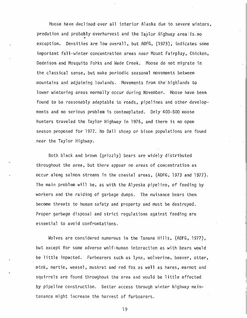
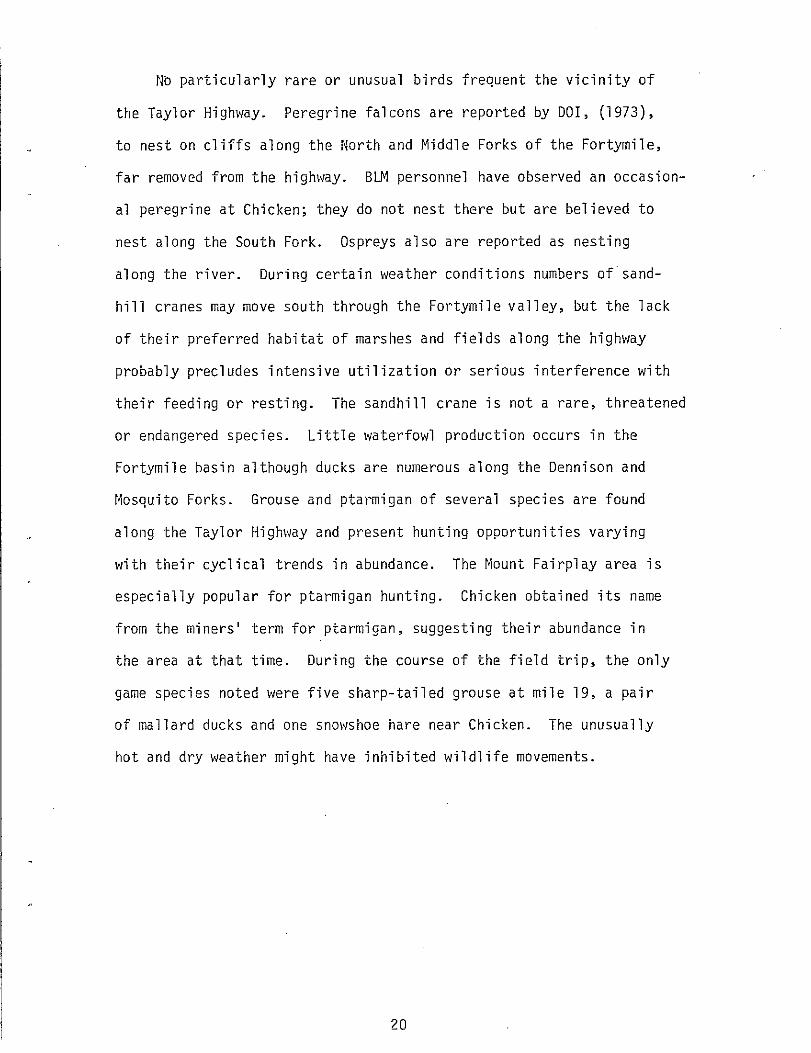
chosen at approximately mile 20 and mile 102. The mile 20 location
appears well placed in the rolling forested hills, (Figures 2 and 3),
but mile 102, in the alpine terrain about 6 miles east of the Eagle
junction may require further investigation before determination of
exact siting to avoid wildlife conflict. Because of the emphasis
on summer construction by the Alcan Pipeline Company, impacts to
caribou while on their sensitive wintering grounds will be minimal.
18
~1oose have declined over a 11 interior A 1 ask a due to severe winters,
predation and probably overharvest and the Taylor Highway area· is. no •
exception. Densities are low overall, but ADFG, (1973); indiCates some
important fall-winter concentration areas near Mount Fairplay, Chicken,
Dednison and Mosquito Forks and Hade Creek. Moose do not migrate in
the classical sense, but make periodic seasonal movements between
mountains and adjoining lowlands. lljovements from the=.highlands to
lower wintering areas normally occur during November. Moose have been
found to be reasonably adaptable to roads, pipelines and other develop-
ments and no serious problem is contemplated. Only 400-500 moose
hunters traveled the Taylor Highway in 1976, and there is no open
season proposed for 1977. No Dall sheep or bison populations are found
near the Taylor Highway.
Both black and brown (grizzly) bears are widely distributed
throughout the area, but there appear no areas of concentration as
occur along salmon streams in the coastal areas, (ADFG, 1973 and 1977).
The main problem will be, as with the Alyeska pipeline, of feeding by
workers and the raiding of garbage dumps. The nuisance bears then
become threats to human safety and property and must be destroyed.
Proper garbage disposal and strict regulations against feeding are
essential to avoid confrontations.
Wolves are considered numerous in the Tanana Hills, (ADFG, 1977),
but except for some adverse wolf-human interaction as with bears would
be little impacted. Furbearers such as lynx, wolverine, beaver, otter,
mink, martin, weasel, muskrat and red fox as well as hares, marmot and
squirrels are found throughout the area and would be little affected
by pipeline construction. Better access through winter highway main-
tenance might increase the harvest of furbearers.
19
No particularly rare or unusual birds frequent the vicinity of
the Taylor Highway. Peregrine falcons are reported by DOl, (1973),
to nest on cliffs along the North and t~iddl e Forks of the Fortymi l e,
far removed from the highway. BLM personnel have observed an occasion
al peregrine at Chicken; they do not nest there but are believed to
nest along the South Fork. Ospreys also are reported as nesting
along the river. During certain weather conditions numbers of sand-
hi 11 cranes may move south through the F01·tymil e v a 11 ey, but the 1 ack
of their preferred habitat of marshes and fields along the highway
probably precludes intensive utilization or serious interference with
their feeding or resting. The sandhill crane is not a rare, threatened
or endangered species. Little waterfowl production occurs in the
Fortymile basin although ducks are numerous along the Dennison and
r~osquito Forks. Grouse and ptal·migan of several species are found
along the Taylor Highway and present hunting opportunities varying
with their cyclical trends in abundance. The Mount Fairplay area is
especially popular for ptarmigan hunting. Chicken obtained its name
from the miners' term for ptarmigan, suggesting their abundance in
the area at that time. During the course of the field trip, the only
game species noted were five sharp-tailed grouse at mile 19, a pair
of mallard ducks and one snowshoe hare near Chicken. The unusually
hot and dry weather might have inhibited wildlife movements.
20
N _.
Figure 2. Mile 20 on the Taylor Highway, looking south . . Figure 3.
,.
Mile 20 on the Taylor Highway, looking north towards Mount Fairplay.
Figure 4. West Fork of the Dennison River, mile 49.
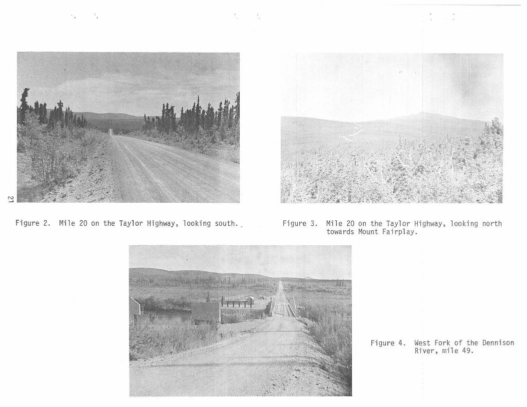
LOG OF THE TAYLOR HIGHVJAY
Mile 0.0 Tetlin Junction.
2.5 Leaving Tetlin Indian Reservation.
4.0 Fourmile Lake one-half mile to the east. Stocked with sheefish and coho salmon by ADFG and reported to provide good fishing.
6.3 Porcupine Creek - a tributary of the Tanana River. About l cfs, temperature 48, moderately silty, of low fishery value but provides grayling fishing according to DOH, (1977). Three 36-inch culverts present - one plugged with silt.
11.3 Unnamed very small stream of less than 0.1 cfs, clear, a headwater tributary of the Dennison Fork.
18.6 Small roadside pond. Five sharp-tailed grouse and a pair of yellowlegs, (Totanus, sp.), observed.
22.0 From mile 0 the road has largely traversed the rolling hills of the Yukon-Tanana uplands through a typical taiga forest of spruce, birch, aspen and alder, (Figures l and 2). The road is largely ridge top with the Dennison Fork to the east and the \-Jest Fork to the west.
26.8 Unnamed small marshy stream of about 0.1 cfs; clear and probably productive; a tributary of the Hest Fork.
28.0 Highway ascends into alpine terrain.
28.5 Dry creek bed.
29.8 Spring flows from the hillside, about 0.1 cfs, 40°. Steep terrain would prevent fish access to this point.
31.7 Dry creek bed.
32.3 Creek bed with slight seepage.
32.5 High1vay elevation 3,190 feet; opposite Mount Fairplay, elevation 5,541 feet.
33.2 Small, clear tundra stream of about 0.5 cfs. An unnamed tributary of the 11est Fork.
35.0 Road descends down into the valley of Logging Cabin Creek; parallels the stream for seven miles, which is about l/4 mile away and not visible.
35.8 Culvert over dry stream bed.
40.5 Small unnamed tributary of Logging Cabin Creek drains a swampy area, less than 0.1 cfs. Culvert present.
22
41".3 Dry stream bed with culvert.
43.3 Crossing Logging Cabin Creek. Stream is about 8 feet in average width, 6 inches deep, flow calculated by floating chip method at 3.7 cfs, temperature 50°, gravel bottom, clear water, and would appear to be productive. Grayling present according to ADFG, (undated). New highway bridge under construction.
43.5 Unnamed small stream of less than 0.1 cfs, 2 culverts. A large old fire burn covers area.
44.2 Stream bed and culvert with a trickle of water.
49.5 Crossing West Fork, also called West Fork of the Dennison River. A moderate-sized stream of 40 - 50 cfs occupying a very broad valley. Water clear with slight tannic coloration, temperature 61°. Productive appearing stream; gray: ling, present according to ADFG. Campground and access point to the South Fork Fortymile River Wilderness Canoe Trail, however, except in early spring the water is usually too low to provide an enjoyable trip, (BLM, undated). New highway bridge under construction. Figure 4.
50.0 The West Fork fire burned 203,000 acres in 1966.
50.6 Taylor Creek. Flow about 5 cfs, temperature 49°, clear but discolored by dissolved organic acids. meanders through meadows and appears productive; present according ADFG.
water Stream
grayling
52. 6 ~1a rshy seepage ares, culvert present.
53.9 Unnamed tributary of Dennison Fork; about 1 cfs; slight tannic coloration; probably contains grayling and appears productive.
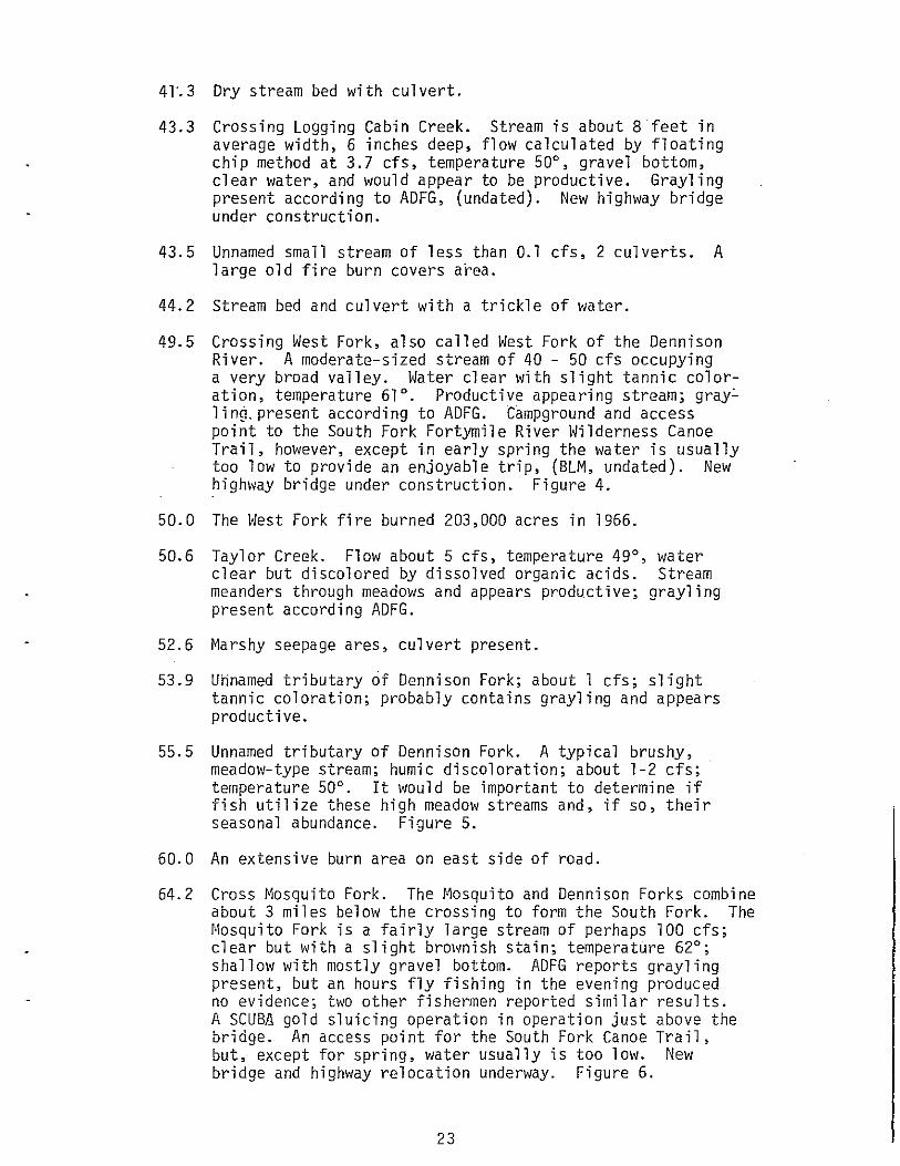
55.5 Unnamed tributary of Dennison Fork. A typical brushy, meadow-type stream; humic discoloration; about 1-2 cfs; temperature 50°. It would be important to determine if fish utilize these high meadow streams and, if so, their seasonal abundance. Figure 5.
60.0 An extensive burn area on east side of road.
64.2 Cross t'Josquito Fork. The t·1osquito and Dennison Forks combine about 3 miles below the crossing to form the South Fork. The t•1osquito Fork is a fairly large stream of perhaps 100 cfs; clear but with a slight brownish stain; temperature 62°; shallow with mostly gravel bottom. ADFG reports grayling present, but an hours fly fishing in the evening produced no evidence; two other fishemen reported similar results. A SCUBA gold sluicing operation in operation just above the bridge. An access point for the South Fork Canoe Trail, but, except for spring, water usually is too low. New bridge and highway relocation underway. Figure 6.
23
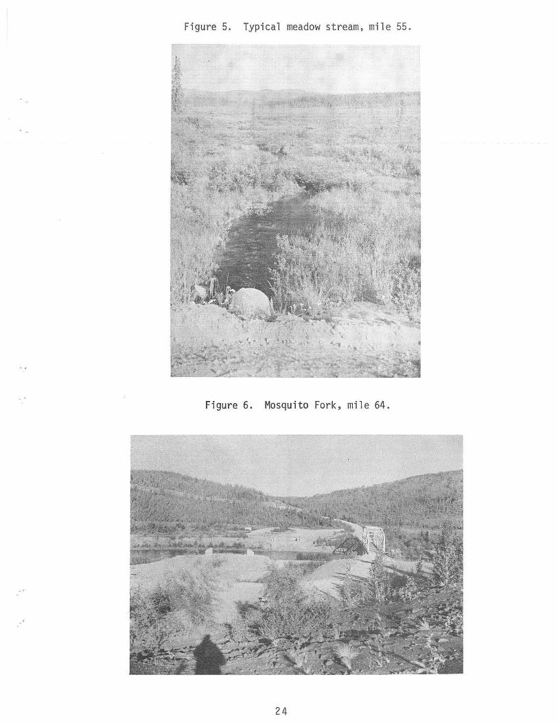
Figure 5. Typical meadow stream, mile 55.
Figure 6. Mosquito Fork, mi le 64.
24
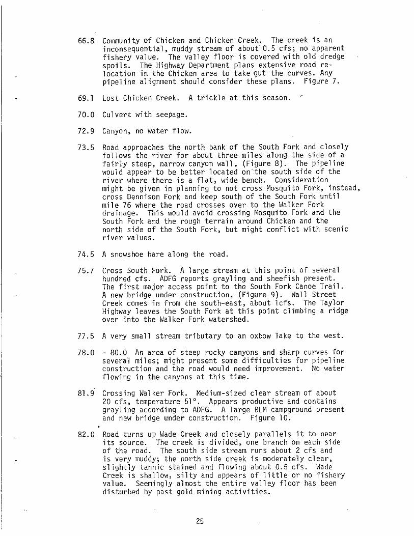
66.8 Community of Chicken and Chicken Creek. The creek is an inconsequential, muddy stream of about 0.5 cfs; no apparent fishery value. The valley floor is covered with old dredge spoils. The Highway Department plans extensive road relocation in the Chicken area to take out the curves. Any pipeline alignment should consider these plans. Figure 7.
69.1 Lost Chicken Creek. A trickle at this season.
70.0 Culvert with seepage.
72.9 Canyon, no water flow.
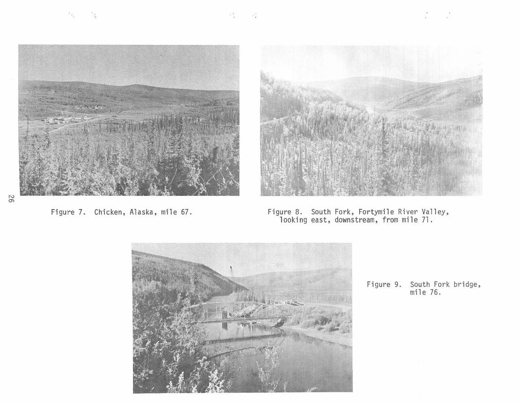
73.5 Road approaches the north bank of the South Fork and closely follows the river for about three miles along the side of a fairly steep, narrow canyon wall, (Figure 8). The pipeline v1oul d appear to be better 1 oca ted on ·:the south side of the river where there is a flat, wide bench. Consideration might be given in planning to not cross Mosquito Fork, instead, cross Dennison Fork and keep south of the South Fork until mile 76 where the road crosses over to the Walker Fork drainage. This would avoid crossing Mosquito Fork and the South Fork and the rough terrain around Chicken and the north side of the South Fork, but might conflict with scenic river values.
74.5 A snowshoe hare along the road.
75.7 Cross South Fork. A large stream at this point of several hundred cfs. ADFG reports grayling and sheefish present. The first major access point to the South Fork Canoe Trail. A new bridge under construction, (Figure 9). Wall Street Creek comes in from the south-east, about lcfs. The Taylor Highway leaves the South Fork at this point climbing a ridge over into the Walker Fork watershed.
77.5 A very small stream tributary to an oxbow lake to the west.
78.0 - 80.0 An area of steep rocky canyons and sharp curves for several miles; might present some difficulties for pipeline construction and the road would need improvement. No water flowing in the canyons at this time.
81.9 Crossing Walker Fork. Medium-sized clear st1·eam of about 20 cfs, temperature 51°. Appears productive and contains grayling according to ADFG. A large BLM campground present and new bridge under construction. Figure 10.
82.0 Road turns up Wade Creek and closely parallels it to near its source. The creek is divided, one branch on each side of the road. The south side stream runs about 2 cfs and is very muddy; the north side creek is moderately clear, slightly tannic stained and flowing about 0.5 cfs. Wade Creek is shallow, silty and appears of little or no fishery value. Seemingly almost the entire valley floor has been disturbed by past gold mining activities.
25
N en
Figu re 7. Chicken, Alaska, mile 67. Figure 8. South Fork, Fortymile River Valley, looking east, downstream, from mile 71.
Figure 9. South Fork bridge, mile 76.
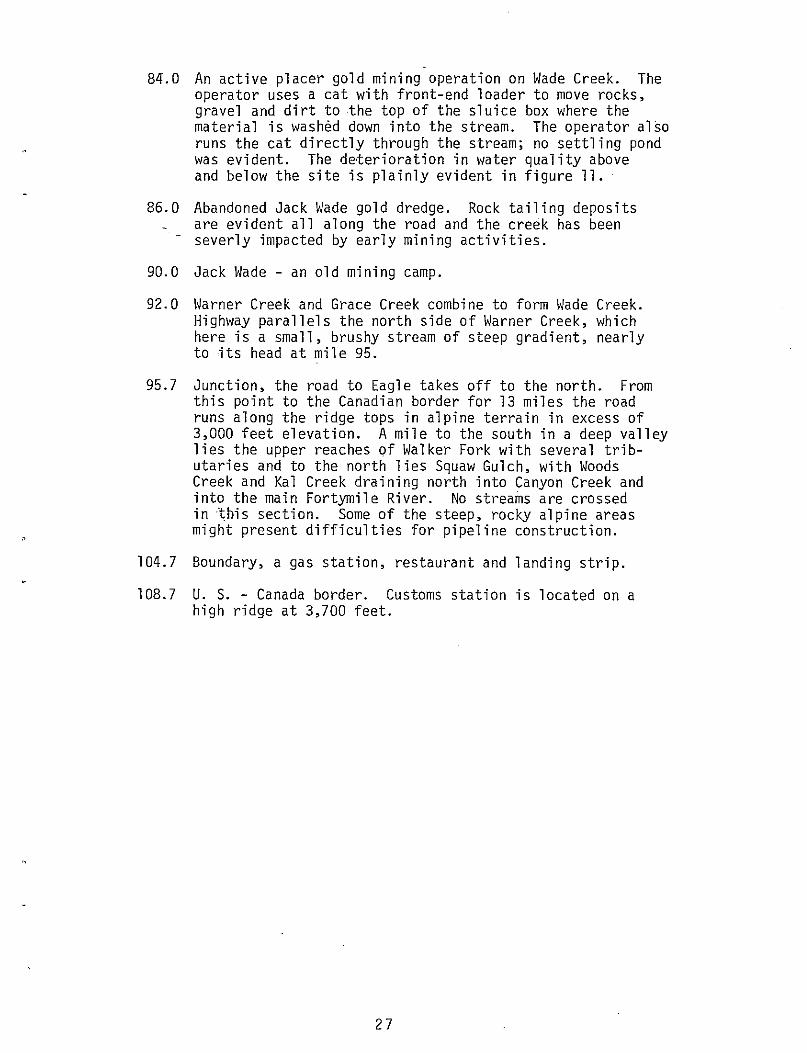
84.0 An active placer gold mining operation on Wade Creek. The operator uses a cat with front-end loader to move rocks, gravel and dirt to the top of the sluice box where the material is washed down into the stream. The operator also runs the cat directly through the stream; no settling pond was evident. The deterioration in water quality above and below the site is plainly evident in figure 11.
86.0 Abandoned Jack Wade gold dredge. Rock tailing deposits are evident all along the road and the creek has been
- severly impacted by early mining activities.
90.0 Jack Wade - an old mining camp.
92.0 Warner Creek and Grace Creek combine to form Wade Creek. Highway parallels the north side of Warner Creek, which here is a small, brushy stream of steep gradient, nearly to its head at mile 95.
95.7 Junction, the road to Eagle takes off to the north. From this point to the Canadian border for 13 miles the road runs along the ridge tops in alpine terrain in excess of 3,000 feet elevation. A mile to the south in a deep valley lies the upper reaches of Walker Fork with several tributaries and to the north lies Squaw Gulch, with Woods Creek and Kal Creek draining north into Canyon Creek and into the main Fortymile River. No streams are crossed in this section. Some of the steep, rocky alpine areas might present difficulties for pipeline construction.
104.7 Boundary, a gas station, restaurant and landing strip.
108.7 U. S. - Canada border. Customs station is located on a high ridge at 3,700 feet.
27
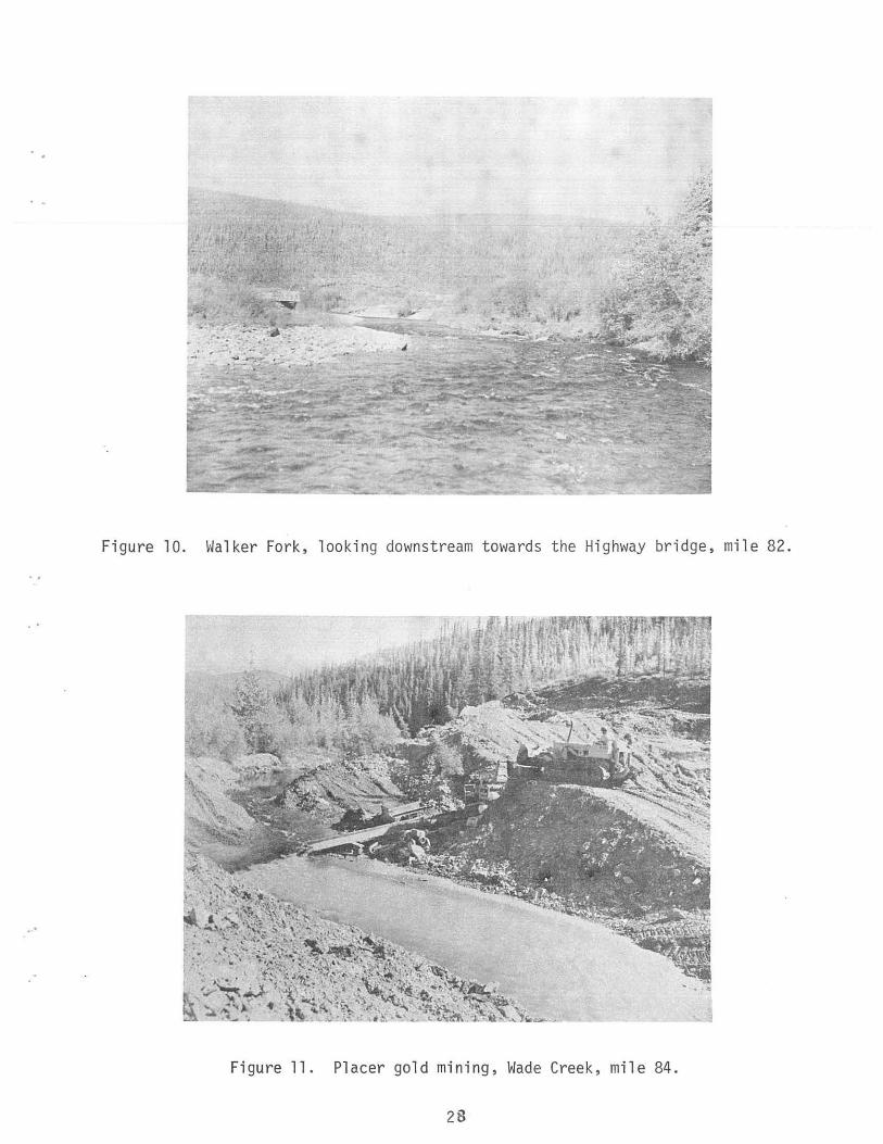
Figure 10. Walker Fork, looking downstream towards the Highway br idge, mile 82.
Figure 11. Placer gold mining, Wade Creek, mile 84.
28
SUit,I~ARY AND CONCLUSIONS
The Canadian National Energy Board proposed that the Alcan natural
gas pipeline swing ~orth to Dawson City, Yukon Territory, via the Taylor
Highway. A preliminary environmental assessment of the Alaska segment
of this alternative route was conducted in August 1977 for the North
west Pipeline Corporation. The Taylor Highway lies in the Northern Plat
eau or Yukon-Tanana Uplands Physiographic Province consisting of broad,
undulating divides with rounded, even-topped ridges seperated by flat,
a 11 uvial va 11 eys. Spruce-hard\~ood forests are interspersed with high
brush thickets, musket-bog, and alpine tundra. There is no glacial or
fault activity along the route. Discontinuous permafrost is widespread
and, combined with soils of high erosion capability results in unstable
earth material subject to thermal degradation and erosion.
Two settlements along the Taylor Highway and scattered miners com
prise a summer population of about 200, which declines to 20 in the win
ter. Gold mining is the principal commercial activity. Gold rush his
tory appears to be the main tourist attraction, with scenic qualities,
fishing, boating, hiking and hunting of lesser importance. The road is
in poor condition and the state is presently replacing most of the brid
ges and has plans to upgrade the road.
The Taylor Highway is mostly within the drainage of the Fortymile
River, a large, complex system with generally clear, good quality water.
The Department of Interior has proposed that much of the Fortymile be
included in the National Wild and Scenic Rivers System. The wild river
portion is far upstream from proposed pipeline; the scenic river sections
29
would be crossed at several points and impinged upon for a short distance,
but the "ri verscape" in this section has a 1 ready been severely impacted by
previous mining and road activity. The overall, long term impact of pipe
line construction on the wild and scenic river values would be negligible.
Gravel required for pipeline construction may be in limited supply and its
removal may be incompatible with scenic and recreational river values.
The development and mitigation of material sites may be one of the major
environmental impacts. The control of erosion and prevention of siltation
in the clear streams must also be recognized.
The Fortymile River has essentially a single-species fishery. Gray
ling are ubiquitous, but not generally abundant and aquatic productivity
is low. Several other fish species occur in the lower river below the
Taylor Highway. The Fortymile caribou herd is the dominant element in
the animal community although greatly reduced from its former abundance.
The herd's ca 1 vi ng grounds and summer range are far west of the Taylor
Highway and they winter generally east of the highway. No serious con
flict with a buried pipeline is anticipated if compressor stations, work
camps and construction activities are integrated with the herd's migra
tory patterns. No rare, threatened or endangered species are recorded
for the highway area and the only other wildlife problem envisioned is
one of bear-human confrontation.
This preliminary assessment revealed no major, long term environ
mental impacts affecting the productivity of the Fortymile area, if con
struction is scheduled to consider the migration of fish and wildlife
and high standards in erosion control and compatability with aesthetic
values are maintained. Before final alignments and const1·uction schedules
30
are programmed, however, several studies need to be completed to pro-
vide data for planning and design to minimize environmental concerns:
(1) site-specified, baseline fishery studies to determine seasonal
species abundance at each crossing and spawning and overvli nteri ng
areas; (2) documentation of past and present fall and spring caribou
migrations along the Taylor Highway in terms of spatial and temporal
distribution; and (3) rock and gravel requirements for the work pad
and pipeline, resources available, and the environmental ramifications
of removal.
Although, the Alaska Taylor Highway segment of the Dawson alter-
native presents no major environmental problems, it appears to be less
attractive than the prime route down the Alaska Highway from a number
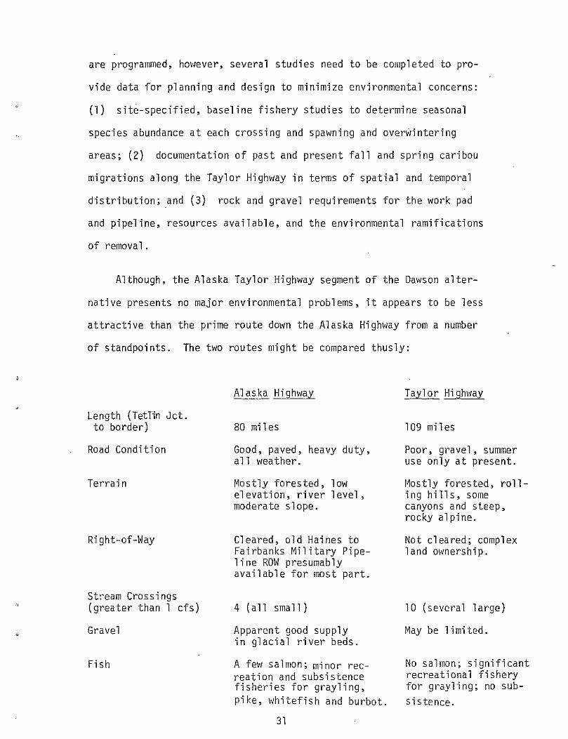
of standpoints. The two routes might be compared thusly:
Length (Tetlin Jet. to border)
Road Condition
Terrain
Right-of-Way
Stream Crossings (greater than 1 cfs)
Gravel
Fish
Alaska Highway
80 miles
Good, paved, heavy duty, all weather.
Mostly forested, low elevation, river level, moderate slope.
Cleared, old Haines to Fairbanks Military Pipeline ROW presumably available for most part.
4 (all small)
Apparent good supply in glacial river beds.
A few sa 1 mon; minor recreation and subsistence fisheries for grayling, pike, whitefish and burbot.
31
Taylor Highway
109 miles
Poor, gravel, summer use only at present.
r~ostly forested, rolling hills, some canyons and steep, rocky alpine.
Not cleared; complex land ownership.
10 (several large)
May be limited.
No salmon; significant recreational fishery for grayling; no sub-sistence.
,,
"
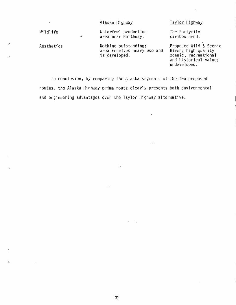
Wildlife •
Aesthetics
Alaska Highway
Waterfowl production area near Northway .
Nothing outstanding; area receives heavy use and is developed.
Taylor Highway
The Fortymi 1 e caribou herd.
.Proposed Wild & Scenic River; high quality scenic, recreational and historical value; undeveloped.
In conclusion, by comparing the Alaska segments of the two proposed
routes, the Alaska Highway prime route clearly presents both environmental
and engineering advantages over the Taylor Highway alternative.
'·'
REFERENCES
Alaska Department of Fish & Game. Alaska Sport Fishing Guide.
Alaska Department of Fish & Game. Alaska's Wildlife and Habitat.
Undated. 96 p.
1973. 144 p.
Alaska Department of Fish & Game. 1977. Alaska Wildlife Management Plans, Interior Alaska. 200 p.
Alaska Department of Highways. 1977. Environmental Impact Statement, Taylor Highway - Tetlin Junction to Canadian Border. 202 p.
Gasaway, W. C. Undated. Status of the Fortymile Caribou Herd. Alaska Department of Fish & Game, Wildlife Informational Leaflet No. 1, 4 p.
Hemming, J. E. 1971. The Distribution and Movement Patterns of Caribou in Alaska. Alaska Department of Fish & Game, Game Tech. Bull. No. 1, 60 p.
Johannsen, E. 1976. Rafting Down the Fortymile. Alaska Mag., June 1976: 4-8.
Schetzle, H. 1976. Alaska Gold Fever. Alaska Mag., June 1976: 41-43.
Selkregg, L. 1977. Alaska Regional Profiles -Yukon Region. University of Alaska Arctic Environmental Information and Data Center. 346 p.
U.S. Bureau of Land Management. Undated. Alaska's Historic Eagle and Taylor Highway, Phamphlet.
U. S. Bureau of Land Management. Undated. Alaska's River Trails, Northern Region, Phamplet.
U. S. Bureau of Land Management. 1976. 40-mile Planning Unit, Unit Resource Analysis, 2 volumes.
U. S. Department of the Interior. 1973. Fortymile National Wild and Scenic River, Alaska. Final Environmental Impact Statement. 422 p.
33
J
U. S. Geological Survey. 1957. Water Supply•Paper 1372. Compilation of Records of Quantity and Quality of Surface Waters of Alaska Through September 1950.
U. S. Geological Survey. 1958. Water Supply Paper 1486. Quantity and Quality of Surface Waters of Alaska, October 1953 to September 1956.
U. S. Geological Survey. 1976. ~later Supply Paper 2136. Surface Hater Supply of the United States, 1966-70, Part 15, Alaska. 428 p.
34


![Topography [m] Phase [cyc] · 200 300 400 500 Topography [m] Topography [m] ... [WYh.dsf [^ g]Kdsf [QZa_FfgX no]FWYbY]= fg`cb VQWo Z\ ... UM [eQoQ QoQ QoQ Q](https://img.pdfslide.tips/doc/110x75/5b509d097f8b9a5a6f8ed326/topography-m-phase-cyc-200-300-400-500-topography-m-topography-m-.jpg)