Embed Size (px)
Citation preview

2014-C44
Changing Population Geography in South Asia
Economic Division in British India
Abu Shonchoy and Kenmei Tsubota
March, 2015
Institute of Developing Economies
Japan External Trade Organization
調査研究報告書 (Chosa Kenkyu Report)
[Interdisciplinary Studies Center]2014-C44
[Economic Division in British India]

1
Interim Report for Economic Division in Colonial India, IDE-JETRO, 2014
Changing Population Geography in South Asia+
Shonchoy Abu and Kenmei Tsubota
Institute of Developing Economies, JETRO
March, 2015
Abstract
This paper is an interim report for the study of Economic Division
in Colonial India. The study is to delve further understandings of historical
changes in population geography and economic geography in Indian
subcontinent during 20th century. Based on the uncompleted database, it
focuses on the feasibility of the study in Bengal region in particular with
particular interests on the partition in Indian Subcontinent. On the course
of constructing the database, this interim report shows some possible
studies within the scope of this project.
This work is a part of the project on “Economic Division in Colonial India”. As the title
of this report shows, the project is still in progress and this paper includes very
preliminary results and analysis. Its contents may be modified based on the updated
available data.
+ We would like to acknowledge Arif Khan and his team for his excellent research
assistance for data entry.

2
1. Introduction
International borders split spaces into different countries and add obstacles
for international transactions. The emergence of international borders in South
Asia, where it was British India until 1947, made substantial changes and has
formed different countries. This region is unique because it has been
extensively censused since 1873.
The impact of economic division is not negligible and can be observed at
present. For example, Dhaka, capital city of Bangladesh, has several
manufacturing industries but these industries appeared after the partition from
India and succeeding independence from Pakistan. Until the partition, Calcutta
was the largest international port. Since the regions of Bangladesh are relatively
near to Calcutta, they had served as its hinterland and it means the growth of
manufacturing industries was economically prevented. After the partition, the
centripetal force, in the other words agglomeration force, of Calcutta was
weakened and East Bengal was released from this force. Then, Dhaka could
start absorbing the abundant economic benefit and increased its potential. The
history of Dhaka and those of each manufacturing industry in Dhaka tell us
how economic division was important for their growth1. However, it does not
tell the growth in the rest of Bangladesh nor the corresponding side of India
such as West Bengal, Assam and Northeast India. It is also inferred that there
would be similar phenomena emerged in India/Pakistan border. For any
regions of British India, historical growth is directly or indirectly affected by the
partition and independence. The quantitative impacts of economic division are
crucial for its understandings of relations among competing regions within and
between countries.
This paper is an interim report for the research projects on Economic Division
in British India, whose purpose is to quantify above mentioned impacts of the
1 During colonial period, jute was produced in East Bengal and manufactured in West
Bengal. After the partition, the reactions by each region showed clear difference. East
Bengal started their investment for manufacturing and West Bengal increased their
cultivation. See Bharadwaj and Fenske (2012) and Tsubota (2014). For another example,
leather manufacturing is found to grow in the same path in East Bengal. See
Murayama and Tsubota (2014) in detail.

3
emergence of international borders in Indian Subcontinent.2 The project covers
not only colonial period but post-partition period, throughout 20th century, and
not only British territory but native states. Based on the available database
which has not been completed3, this paper focuses on the feasibility of the study
in Bengal region in particular with particular interests on the partition in Indian
Subcontinent. On the course of constructing the database, this interim report
shows some possible studies within the scope of this project.
Table 1. Number of Census volumes from 1901 to 19314
While there are many attempts to study the population related studies
within India and across Indian Subcontinent, for example Kingsley (1968) and
others, most of the studies employ state level data. The difficulties accessing the
2 This research project also considers the evolution of cities and economic geography
by using remote sensing technique. Another paper by Keola and Tsubota (2015) is
another preliminary attempt to construct colonial geographical information (GIS) and
complement this study.
3 Due to the huge volumes of the census covering this region, the project faced
difficulties in its construction of the database. It may be one of the reasons why our
research question has not been extensively explored. 4 Some volumes are bounded in a book but counted as separate if numbered separately.

4
finer geographical data are in the availability of the database. In the colonial
period, the figures at state level are available from the Census of India
numbered as volume one which summarize the characteristics of each native
states, and British territories. However, all of the district data and further
detailed data in provincial tables are kept in different volumes for each
administrative area. Simple number of the volumes covering the Census of
India shows the efforts needed to collect the scattered tables (Table 1).
Additional difficulties are the separation of regions into different countries
due to the partition and the subsequent independence as Bangladesh. As
different sovereign countries, the censuses were conducted different manner.
Until 1961, the population census for India and Pakistan took similar format as
was in the colonial period. However, the following census after 1970s
developed themselves in a simpler format, different aggregations, and different
timing (Table 2). This change causes the loss of comparability in some articles.
Table 2. Census held after 1947
Kingsley (1968) is one of the exceptions which cover India and Pakistan as a
whole. However, as is pointed out by Schendel (2004), studies in the
subcontinent are also partitioned by the international borders and the
comparative studies of the regions in the subcontinent are rather scarce. Our
project is to fill out this gap and try to provide the evidence of economic
division. It would contribute to the impacts of partition and independence of
parts of regions from integrated ones. It may offer some insights to the current
discussions related with referendums in Scotland, Catalonia, Quebec and others.
Also, if we have economic and regional integration in South Asia goes deeper,
the comparative studies of population and economic geography of the past
where regions were more integrated would show some predictions how future
geography is similar or different from the one in the past.
The rest of the paper is organized as follows. Brief summary of the literature
appears in Section 2. Section 3 examines the changing population geography by
Theil index. Section 4 is discussions and some future studies covered in this

5
research project.
2. Literature review
On the economic division, there are two notable studies, Redding and Sturm
(2008) and Nakajima (2008). Redding and Sturm (2008) is the first study to
examine the impacts of division. Following division, Western German cities
close to the new border with Eastern Germany went from being at the center of
an integrated Germany to being on the periphery of West Germany. They find
that the border regions suffer negative impacts from division of Germany and
show lower population growth. Nakajima (2008) conduct the same
methodology to Japan-Korean division after the World War II. He also finds
similar results that western Japan, which is near to Korea, became to be
periphery of Japan from the center of Empire of Japan.
In both studies, they only focus on one side of the divided regions. It is not
natural to assume the impact be symmetric. It would be possible to have
different impacts in both sides but such studies are not examined. Furthermore,
while international border is a line to split space into two regions, the effect of
the border might be different at place to place. Such analysis has not been done
yet. Moreover, the relations among the cities got affected but detailed relations
among neighbouring regions are also not analyzed, which means the impact on
urban hierarchy. Our research project explicitly introduces interdependency of
regions and observes the change of the dependency, as well.
There are related studies in India in particular. First set of studies share
similar focus with ours, impacts of partition on population. Hill et al (2008)
particularly examine the impacts in Punjab on demographic distribution.
Bharadwaj, et al (2008) is the first to employ district data and examine the
change in population between 1931 and 1951. They focus on the change in the
composition of the attributing variables such as gender, education, and
occupations. These are the studies on the immediate direct impacts of the
migrations caused by the partition. However, there are some shortcomings the
studies lacks, for example exclusion of the trends before and after partition, and
the geographical position of the districts. More detailed analysis of occupation
data similarly to the population would bring the explanations of rise in
developments occurring post-partition.

6
Another set of studies considers the change of accessibility and its outcomes in
space. Bharadwaj and Fenske (2012) examined the impacts in labour market of
the migrants on wage, employment and production. They find the absorption of
immigrants into jute cultivation smoothly contributed to the increase in its
production and didn’t harm the existing workers’ working conditions.
Donaldson (2014) examined the relation between price equalization and the
advancement of railways in British India. The extension of railways reduces
transport costs and accelerates the flow of information and goods. Thus it
resulted in the equalization of price of goods.
3. Dynamics of population distribution in India
This section examines the population distribution at district level in India.5
During the early 20th century, the population growths in India were lower than
those after partition. This is a trend commonly observed in the world (Figure 1).
Figure 1. Population by Indian states in 1901-2001
For the trend of the composition, we calculate Theil index. This is an index
5 Our database is still not completed and our analysis is limited to the variables and regions where available.

7
to show the dispersion from the uniform distribution and has the property of
decomposability. Since the administrative areas are in the space and are
decomposable for any sub-administrative areas, this decomposability is a useful
feature.
Table 3. Theil Index of population in India
We use the data published as Decadal Variation in Population Since 1901 by
Office of the Registrar General and Census Commissioner, India. There are
mainly three types of cravats on the use of this data but all of the three are on
the missing data.6 Firstly, there are no sub-state data but are total of state
during the colonial period. Such examples are Delhi, Sikkim, Manipur, and
Mizoram, even we have some disaggregates after partition and we use
aggregated figures throughout the period of our analysis. Second, there is no
census in Arunachal Pradesh State before 1961. Due to the impossibility of
comparison before and after, we drop observations of districts and state in
Arunachal Pradesh. Thirdly, there are some states, where some districts were
governed by princely states or from other reasons there is no data during
colonial period. We drop such districts and restrict our analysis for the
comparable observations. Such states are Punjab, Haryana, Nagaland, and
6 The 1981 Census could not be held in Assam. The population figures for 1981 for Assam have been worked out by Interpolation by Census Registrar.

8
Assam.7
Table 3 shows the time series trend of the index. Overall indicates the overall
Theil index and Between is disparities among states and territories. Between
index shows decreased until 1931, increased to 1961 and turned to decrease
afterwards. It suggests that there may be higher inter-state migration and/or
changes in fertility behavior.
4. Dynamics of population in Bengal
4.1. Population disparity
In this section, particularly focusing on Bengal region, we compare the
distributional change of population. East Bengal was former East Pakistan and
is Bangladesh. The data of East Bengal is obtained from Statistical Yearbook of
Bangladesh. West Bengal is the corresponding districts of the data used in the
previous section. The analysis restricts data for West Bengal, India and
Bangladesh as East Bengal.8 When there are districts which split from larger
districts, we merged such districts with the one split from. For example,
Jamalpur and Tangail are merged to Mymensingh and Patuakhali to Barisal.
Data for Western districts are the same source as in the previous section.
Over a century, Figure 2 shows the populations of East Bengal and West
Bengal have grown in the same trend.
7 In the revision of our paper, it would be needed to compare how Theil Index changes for the period we have data as a part of robustness check. If we have significant
correlations between pre and post partition period, the Theil Index of the colonial period can be calculated. 8 However, our future revision doesn’t exclude the inclusion of Assam and other neighbouring regions.

9
Figure 2. Population of Bengal in 1901-2001
With closer look of the population growth at district level and with
comparison before and after the partition, districts can be classified into two
types. Some changed their trends and the others followed the same trends. The
effects and non-effect of the partition is the interests of this paper. A
timer-series comparison of the population distribution is shown by Theil Index
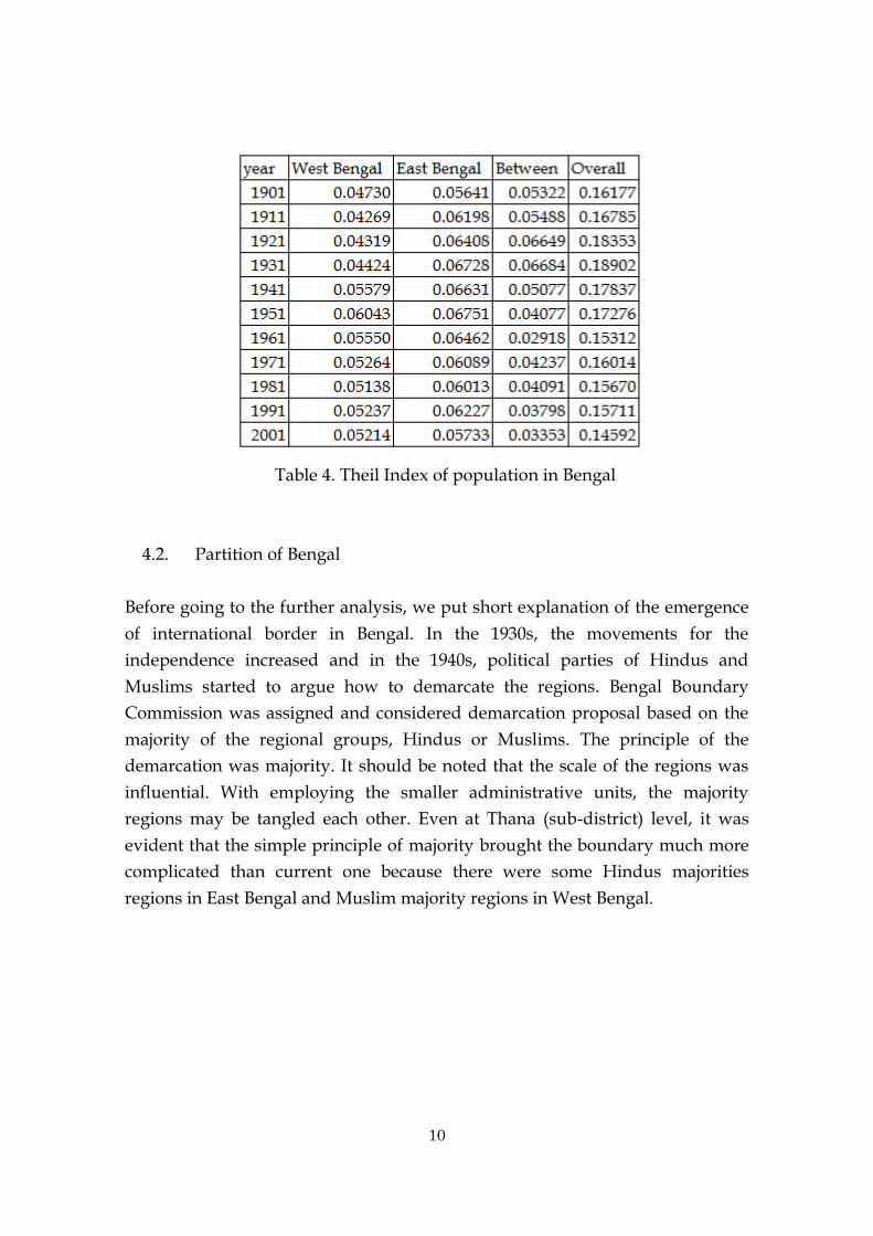
as in Table 4. The comparison between East and West shows that relatively
higher disparity of population is observed in East Bengal over time. Disparity
between East and West increased from 1901 to 1931 but suddenly decreased
until 1961. After the jump to 1971, disparities between East and West are
steadily decreasing. The lower figure in 1961 is doubtful and should be checked
again.
10
Table 4. Theil Index of population in Bengal
4.2. Partition of Bengal
Before going to the further analysis, we put short explanation of the emergence
of international border in Bengal. In the 1930s, the movements for the
independence increased and in the 1940s, political parties of Hindus and
Muslims started to argue how to demarcate the regions. Bengal Boundary
Commission was assigned and considered demarcation proposal based on the
majority of the regional groups, Hindus or Muslims. The principle of the
demarcation was majority. It should be noted that the scale of the regions was
influential. With employing the smaller administrative units, the majority
regions may be tangled each other. Even at Thana (sub-district) level, it was
evident that the simple principle of majority brought the boundary much more
complicated than current one because there were some Hindus majorities
regions in East Bengal and Muslim majority regions in West Bengal.

11
Figure 3. Sub-district of Bengal with current international borders9
Figure 3 shows the boundary of administrative units at 1931 and the
current national boundary. While each Bengal is plainly colored, each region
experienced different growth. It may also be related with the different
effectiveness and tensions of international borders. Schendel (2004) pointed out
that Indo-Bangladesh border is not uniformly effective, which suggests that the
impacts of the partition would also be different among regions. The border is
drawn in one long line surrounding Bangladesh. However, the meaning and
the influence of the border doesn’t have to be uniform. These points may be
examined in the analysis by changing the definition of effective border.
9 Sub-district maps appeared in Census of India (1931), Vol. V, Part I, by each division with the name list. Unfortunately, such detailed maps and list only appeared for Bengal and not for other states. Even for Bengal, maps in the other years are not as precise as those in 1931.

12
Table 5. Summary statistics
4.3. Methodology
For the estimation, we compare the change of the trends in population
growth by employing difference in difference method. Following the
specification of Redding and Sturm (2008) and Nakajima (2008), our regression
equation is written as,
∆ln𝑝𝑜𝑝𝑟𝑡 =∑ 𝛿𝑖𝑁
𝑖=1𝜂𝑖 +∑ 𝜃𝑖
𝑁
𝑖=1𝐵𝑜𝑟𝑑𝑒𝑟𝑖 + 𝜖𝑟𝑖 ,
While there is only one international border emerged, in 1940s there were
13
wider discussion in the choice of this international border including the above
mentioned majority principle. By changing the affected regions, we may
consider the impact of partition as a sensitivity analysis. Since some of the
variables related with border is not prepared, we cannot examine further
analysis at this stage. However, in the following fiscal year, with the complete
dataset, we should be able to analyze such impacts. Not only difference in
difference method, but also regression discontinuity design may be useful when
we have larger samples.
5. Discussion and future directions
Population geography in Indian Subcontinent is not well explored because
of the less data on fertility and huge collection of census covering entire regions
with split by the international borders. The international border split not only
the regions in continuous space but also the academic studies. The
comprehensive set of the data at both sides allows us to see the evolution after
the partition.
The emergence of international border in Bengal is a unique event. The
region is equipped with well-established population census and the political
discussions on partition are extensively analyzed by Indian Historians until
today. However, still the quantitative analysis of the impact of partition is left
aside. Our research project comes into this knowledge gap to fill out.
References
Bharadwaj, Prashant and James Fenske (2012) “Partition, Migration, and
Jute Cultivation in India”, Journal of Development Studies, Vol. 48 (8),
pp1084-1107
Bharadwaj, Prashant, Asim Khwaja and Atif Mian (2008) “The Big March
– Migratory Flows After the Partition of India”, Economic and Political Weekly,
Vol 35 No. 43, pp39-49
Bharadwaj, Prashant, Asim Khwaja and Atif Mian (2014) “Population
Exchange and its Impact on Literacy, Occupation and Gender – Evidence from
the Partition of India”, International Migration, forthcoming

14
Hill, K., W. Seltzer , J. Leaning , S. J. Malik , S. S. Russell (2008) “The
demographic impact of Partition in the Punjab in 1947”, Population Studies, Vol.
62 (2), pp155-170

調査研究報告書 (Chosa Kenkyu Report)
[Interdisciplinary Studies Center]2014-[C44]
[Economic Division in British India]
2015年 3月 31日発行
発行所 独立行政法人日本貿易振興機構
アジア経済研究所
〒261-8545 千葉県千葉市美浜区若葉 3-2-2
電話 043-299-9500
無断複写・複製・転載などを禁じます。