Embed Size (px)
DESCRIPTION
Conservation Management Plan for Penllergare Valley Woods
Citation preview
Ymddiriedolaeth PenllergareThe Penllergare Trust
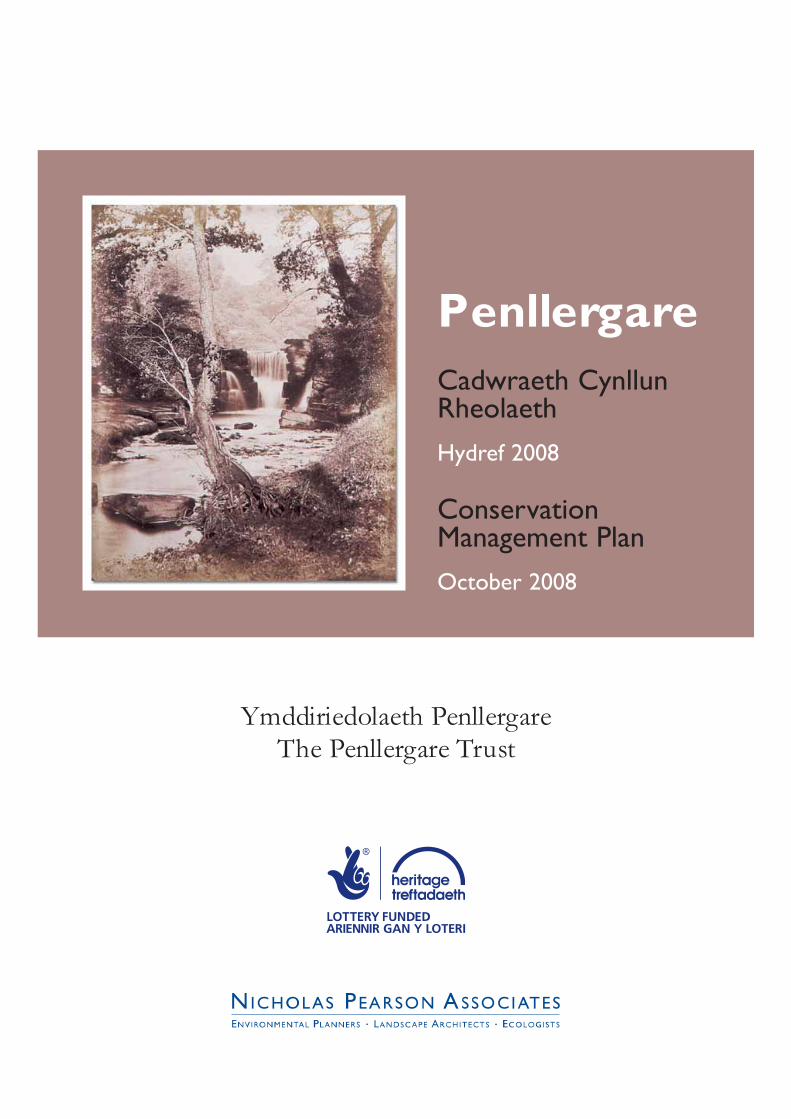
PenllergareCadwraeth CynllunRheolaeth
Hydref 2008
ConservationManagement Plan
October 2008
PenllergareCadwraeth CynllunRheolaeth
Hydref 2008
ConservationManagement Plan
October 2008
Ymddiriedolaeth PenllergareThe Penllergare Trust
Penllergare Valley Woods PEN.060__________________________________________________________________________________________
CONTENTS
EXECUTIVE SUMMARY • CRYNODEB GWEITHREDOL
ACKNOWLEDGEMENTS
1.0 INTRODUCTION
2.0 METHODOLOGY
3.0 SUMMARY HISTORY AND ANALYSIS
4.0 SITE CONTEXT
5.0 SIGNIFICANCE AND OBJECTIVES
6.0 GENERAL POLICIES AND PROPOSALS
7.0 AREA PROPOSALS
FIGURES
1. Site Location and Context
2. Bowen’s and Yates’s county maps, 1729 and 1799
3. The Ordnance Survey Surveyor’s Drawing, 1813
4. The Ordnance Survey Old Series map, 1830
5. Tithe Map, 1838
6. The Garden
7. The Waterfall
8. The Upper Lake
9. The Valley
10. The Lower Lake
11. The Drive
12. The Quarry
13. The Orchid House
14. Fairy Land, The Shanty and Wigwam
15. Panorama of Penllergare
16. Ordnance Survey six-inch map, frst edition, 1875-8
17. Ordnance Survey 1:2500 map, second edition, 1898
18. Ordnance Survey 1:2500 map, third edition, 1916
19. Ordnance Survey 1:2500 map, fourth edition, 1936
20. Air Photograph, 1946
21. Ownership
22. Location of Sites and Monuments surveyed by Cambria Archaeology
23. Simplifed Ecological Habitats, 2002
__________________________________________________________________________________________The Penllergare Trust 1 Nicholas Pearson Associates Ltd.Conservation Management Plan
Penllergare Valley Woods PEN.060__________________________________________________________________________________________
24. Access to the Valley Woods
25. An Interpretation of Open Ground Management in 1877
26. Site Description Areas
27. Cultural Heritage Constraints, Cambria Archaeology
28. Proposed Landscape Management
29. Visitor Facilities Options
APPENDICES
Appendix 1 References
Appendix 2 Historic Landscape Gazetteer
Appendix 3 Listed Building, Scheduled Ancient Monument and Register entries
Appendix 4 Project Programme
Appendix 5 Outline Project Cost Plan
Appendix 6 Hydropower Feasibility Study
Appendix 7 Ordnance Survey 25 inch 1st Edition
Appendix 8 Core Area Masterplan; Existing Survey
Appendix 9 Access, Audience Development and Training Plan
Appendix 10 Condition Survey and Recommendations
Appendix 11 Feasibility Cost Estimates
EXECUTIVE SUMMARY
__________________________________________________________________________________________The Penllergare Trust 2 Nicholas Pearson Associates Ltd.Conservation Management Plan

Penllergare Valley Woods PEN.060__________________________________________________________________________________________
Penllergare Valley Woods is a relict but highly signifcant designed historic landscape located on the
edge of Swansea, Wales’s second largest city. The Valley Woods are currently cared for, without
either ownership or a secure tenancy, by a local charitable group, the Penllergare Trust. Without
secure tenure, the Penllergare Trust has concentrated on promoting the need to protect the site,
locally and nationally, and also on improving our understanding of the history and nature of
Penllergare. The Trust has been very successful, with a large and active Friends group, many
volunteers, two books published and sold out, and a busy schools and guided walks programme.
However, there is an urgent and recognised need to improve the conservation and appreciation of
important historic features including two Scheduled Ancient Monuments and listed structures ‘at
risk’, and to identify how the site’s public amenities can be sustained in the long term. This
Conservation Management Plan has been produced to address these issues and forms part of a bid
for funding from the Heritage Lottery Fund and Big Lottery Fund Parks for People initiative.
Importance of the park
The plan, commissioned by The Penllergare Trust, with support from Parks for People, demonstrates
both the historic and present importance of the park:
• The Valley constitutes what remains of the unique picturesque landscape created by the
Llewelyn family, notably Lewis Weston Dillwyn, John Dillwyn Llewelyn and Sir John Talbot Dillwyn
Llewelyn, that exploited the natural topography on a grand scale.
• Penllergare forms the historic core of an ancient estate, once home of the powerful local
Glamorgan Price and Mathews families.
• Lewis Weston Dillwyn, John Dillwyn Llewelyn and Sir John Talbot Dillwyn Llewelyn were
prominent fgures in Victorian society, and pioneers of technology, science and photography. As a
result, Penllergare has an exceptionally rare and detailed photographic record of the estate’s
appearance in its prime.
• The landscape has survived, albeit in a severely neglected state, through a turbulent century
of economic, industrial and social change, on the urban fringe of Swansea.
• Penllergare includes an historic astronomical observatory and the remains of a pioneering
Victorian orchid house, both designated as Scheduled Ancient Monuments.
• It is a popular green space for quiet recreation and enjoyment by the local communities, and
possesses an unusual sense of community ownership which stems from a history of public access
since the late nineteenth century. It is slowly being brought back into management by a group of
volunteers, trainees and Penllergare Trust staff.
__________________________________________________________________________________________The Penllergare Trust 3 Nicholas Pearson Associates Ltd.Conservation Management Plan

Penllergare Valley Woods PEN.060__________________________________________________________________________________________
• The park is a valuable haven for wildlife with extensive woodland, the river Llan, wetland and
grassland habitats, slowly being brought back into management by a group of volunteers, trainees and
Penllergare Trust staff.
Some problems
However, Penllergare is not without its problems:
• the twentieth century has seen a division of ownership, pressures from highway, residential and
commercial development, procrastination over future use, failures in the planning system, and lack of
clear responsibility for management. As a result, Penllergare’s historic landscape and character has
been seriously, and, in parts, irreversibly, compromised through neglect, insensitive development and
poor quality engineering works;
• many historic landscape features have been lost, and those that remain require extensive
conservation and repairs;
• there are no visitor facilities or accommodation for school visits, trainees, maintenance staff or Trust
meetings;
• there is no dedicated car parking, and what there is, is minimal, shared with other uses or perceived
to be insecure;
• the two Scheduled Ancient Monuments are poorly interpreted, largely concealed and in very poor
condition;
• the upper lake is heavily silted; the lower lake dam has been breached, reducing the extent of open
water which played a key historic role in the designed landscape and biodiversity;
• sustainable means of access by cycle and rail are limited, while bus and footpath links are not yet
widely promoted;
• many paths remain muddy, overgrown and in poor condition, and there are very few benches or
waymarkers, limiting access for all;
• the valley lacks a clear sense of spatial order and of identity through the loss of historic buildings,
minimal signage, lack of interpretation and proximity to busy roads.
Management proposals
The conservation management plan sets out a number of proposals to address these weaknesses,
and to improve both the quality and the capacity of Penllergare for free public access and enjoyment.
Physical improvements are shown on the Valley masterplan, but other proposals include:
• a commitment by the Penllergare Trust to establish a secure interest in the tenure of the
Valley Woods;
__________________________________________________________________________________________The Penllergare Trust 4 Nicholas Pearson Associates Ltd.Conservation Management Plan
Penllergare Valley Woods PEN.060__________________________________________________________________________________________
• dedicated investment and effort to sustain and develop the consultation processes and local
community involvement in the management of the Valley;
• partnerships with local volunteers, social and commercial businesses, and development of
the Friends group;
• improved interpretation, signage, website, accessibility and events, so that the site gives a
wider welcome;
• an enhanced events programme which reveals some of the history of the estate;
• increased involvement with local schools, and colleges, around the estate, and outreach
work in local communities.
The above programmes are detailed further in a companion report, the Access, Audience
Development and Training Plan by VZJ Associates.
Key themes
Interpretation will focus on a number of key themes arising from the history of Penllergare:
• The role of Lewis Weston Dillwyn, John Dillwyn Llewelyn, and Sir John Talbot Llewelyn as leading
fgures in nineteenth century Britain, pioneers in industry, technology, horticulture, and science, and
instigators and philanthropists in the development of Swansea and the surrounding area.
• Penllergare as art; in an internationally unique collection of early photographs, in paintings and
sketches, and as an important nineteenth century designed landscape.
• Penllergare as a site of important scientifc discoveries and experiments, surviving in documentary
accounts and the equatorial observatory.
• A substantial and well-recorded walled garden, and the intensity, innovations and discoveries of
Victorian gardening.
• Penllergare’s rich biodiversity, habitats and wildlife.
Proposed works
Proposals shown on the masterplan include:
• proposals for the location of dedicated visitor facilities to include a community training, meeting and
education room, toilets, and the provision of a café or refreshment kiosk;
• proposals for the creation of a small dedicated car park;
• the creation of an accessible interpretative tour around the Valley, with improved pedestrian routes,
restoration of historic pathways and additional fully accessible footbridges to create a greater variety
of circuits;
__________________________________________________________________________________________The Penllergare Trust 5 Nicholas Pearson Associates Ltd.Conservation Management Plan

Penllergare Valley Woods PEN.060__________________________________________________________________________________________
• de-silting of the Upper Lake to reinstate its historic form, and prevent total reversion to marshland;
• introduction of site furniture and signage to increase welcome and accessibility, using carefully
selected designs to minimise impact on the historic landscape;
• thinning and management of areas of dense trees and shrub to reopen historic views;
• creation of a dedicated works area with compost bays, secure storage and mess room for Woodland
Management Team;
• repair and restoration of the historic steps, terraces, footbridges, retaining walls, and, where viable,
waterfalls and cascades;
• careful integration of the sewage pipe over the river Llan, and recreation of the old stone bridge as a
fully accessible river crossing and visual feature in the landscape;
• replanting of specimen trees and ornamental shrubberies lost from the existing landscape;
• maintaining and enhancing biodiversity;
• improved screening of the housing on the western side of the landscape;
• removal of visually intrusive and redundant weirs along the Llan below the Lower Lake;
• restoration and conversion of the walled garden, gardener’s cottage and adjacent areas for
horticultural training and as a visitor attraction;
• securing the Valley Woods boundary, particularly along the western perimeter to reduce anti-social
behaviour and the perception of unkempt wasteland;
• restoration of the Lower Lake and cascade is only put forward as a lower priority, future project.
Where practical, the Ordnance Survey map of 1876 forms the guide for conservation management
of the landscape, as this records the last complete phase of the designed mid-nineteenth century
landscape. However this is to be supplemented by continued research into the historic and
archaeological importance of the site, and the scope to interpret the history of Penllergare further
through planting, management and maintenance.
This report also includes, in outline, management and maintenance proposals which detail how the
long term values of the park will be sustained and enhanced through landscape maintenance, holistic
administration and community involvement.
Funding
The plan also sets out the costings of the proposals and allowances for infation, fees, and improved
maintenance, totalling some £ 4.6 million over three years. It is proposed to meet these costs with a
grant application to the Heritage Lottery Fund and Big Lottery for £3.4 million; partnerships and
__________________________________________________________________________________________The Penllergare Trust 6 Nicholas Pearson Associates Ltd.Conservation Management Plan

Penllergare Valley Woods PEN.060__________________________________________________________________________________________
involvement with the local social enterprises and volunteers; and partnership funding from Cadw and
others.
Timing
This Conservation Management Plan will be submitted to the Heritage Lottery Fund, seeking
support for the development stage, including detail surveys, archaeology, detail plans, further local
consultation and consents. This information would then be submitted to support a full grant for
restoration. If successful, this whole process is likely to take about two years before works would
start on the ground. The works would be spread over a three year programme.
__________________________________________________________________________________________The Penllergare Trust 7 Nicholas Pearson Associates Ltd.Conservation Management Plan
Penllergare Valley Woods PEN.060__________________________________________________________________________________________
CRYNODEB GWEITHREDOL
Mae Coedig Cwm Penllergare yn dirlun creiriol, ond yn dirlun hanesyddol wedi’i gynllunio
arwyddocaol dros ben, wedi’i leoli ar gyrion Abertawe, ail ddinas Cymru. Ar hyn o bryd, grŵp
elusennol lleol, sef Ymddiriedolaeth Penllergare sy’n edrych ar ôl Coedwig y Cwm, er nad oes
ganddynt berchnogaeth neu chwaith denantiaeth ddiogel o’r safe. Gan nad oes ganddynt
ddeiliadaeth ffurfol, mae Ymddiriedolaeth Penllergare wedi canolbwyntio ar hyrwyddo’r angen i
warchod y safe, yn lleol ac yn genedlaethol, ac hefyd ar wella’n dealltwriaeth o hanes a natur
Penllergare. Mae’r Ymddiriedolaeth wedi bod yn llwyddiannus iawn, gyda grŵp Ffrindiau mawr a
gweithgar, llawer o wirfoddolwyr, dau lyfr wedi eu cyhoeddi ac wedi gwerthu mas, rhaglen brysur i
ysgolion a rhaglen o deithiau tywys. Serch hynny, mae gwir angen cydnabyddedig i wella’r
warchodaeth a’r gwerthfawrogiad o nodweddion hanesyddol pwysig, gan gynnwys dwy Heneb
Gofrestredig a strwythurau eraill sydd ‘o dan fygythiad’, ac i adnabod sut i gynnal cyfeusterau
cyhoeddus y safe yn yr hir-dymor. Mae’r Cynllun Rheoli Cadwraeth yma wedi’i gynllunio er mwyn
mynd i’r afael â’r materion hyn ac mae’n ffurfo rhan o gais am gyllid o Gronfa Dreftadaeth y Loteri a
menter Parciau i’r Bobl (Parks for People) y Gronfa Loteri Fawr.
Pwysigrwydd y parcMae’r cynllun, a gomisiynwyd gan Ymddiriedolaeth Penllergare, gyda chymorth Parciau i’r Bobl (Parks
for People), yn dangos pwysigrwydd hanesyddol a chyfoes y parc:
• Mae’r Cwm yn cynrychioli’r hyn sydd ar ôl o’r tirlun pictiwésg unigryw a grewyd gan y teulu
Llewelyn, yn benodol Lewis Weston Dillwyn, John Dillwyn Llewelyn a Syr John Talbot Dillwyn
Llewelyn, cynllun sy’n gwneud yn fawr o’r topograff naturiol ar raddfa fawreddog.
• Penllergare yw craidd hanesyddol stad hynafol, a fu unwaith yn gartref i’r teulu Price a’r teulu
Mathews – dau deulu lleol grymus Sir Forgannwg.
• Roedd Lewis Weston Dillwyn, John Dillwyn Llewelyn a Syr John Talbot Dillwyn Llewelyn yn
aelodau blaenllaw o gymdeithas oes Fictoria, ac yn rhagfaenwyr ym meusydd technoleg,
gwyddoniaeth a ffotograffaeth. O ganlyniad, mae cofnod ffotograffg hynod brin a manwl ar
gael a chadw o Benllergare, sy’n darlunio’r stad pan ‘roedd yn ei blodau.
• Mae’r tirwedd wedi goroesi, er mewn cyfwr hynod ddiffaith, canrif gythryblus o newid
economaidd, diwydiannol a chymdeithasol, a’r cyfan ar gyrion trefol Abertawe.
• Mae Penllergare yn cynnwys arsyllfa seryddol o bwys hanesyddol ac olion tŷ tegeirianau
arloesol o oes Fictoria, y ddau’n Henebion Cofrestredig rhestredig.
• Mae’n fan gwyrdd poblogaidd, ac yn cael ei ddefnyddio gan gymunedau lleol ar gyfer adloniant
a mwynhad tawel. Mae ymdeimlad anarferol o berchnogaeth gymunedol yn perthyn i’r lle, gan
fod na hanes o fynediad cyhoeddus i’r safe ers diwedd y bedwaredd ganrif ar bymtheg. Yn
__________________________________________________________________________________________The Penllergare Trust 8 Nicholas Pearson Associates Ltd.Conservation Management Plan

Penllergare Valley Woods PEN.060__________________________________________________________________________________________
araf bach, mae grŵp o wirfoddolwyr, hyfforddai a staff Ymddiriedolaeth Penllergare yn dod â’r
parc yn ôl o dan reolaeth.
• Mae’r parc yn cynnig lloches werthfawr i fywyd gwyllt, gyda’i goedwigoedd helaeth, yr afon
Llan a chynefnoedd gwlyptir a glaswelltir yn araf cael eu hadfer gan grŵp o wirfoddolwyr,
hyfforddai a staff Ymddiriedolaeth Penllergare.
Rhai problemau
Serch hynny, nid yw Penllergare heb ei broblemau:
• Yn yr ugeinfed ganrif gwelwyd raniad ym mherchnogaeth y safe, datblygiadau i briffyrdd a
datblygiadau preswyl a masnachol yn ychwanegu pwysau, oedi ynglyn â’i defnydd yn y
dyfodol, methiannau yn y system gynllunio a diffyg cyfrifoldeb clir o ran rheolaeth. O
ganlyniad, mae tirwedd a chymeriad hanesyddol Penllergare wedi’i gyfaddawdu’n ddifrifol, ac
mewn mannau, yn anadferadwy, drwy esgeulustod, datblygu ansensitif a gwaith peirianegol o
ansawdd gwael;
• mae llawer o nodweddion y tirwedd hanesyddol wedi’u colli, ac mae angen gwaith cadwraeth
ac atgyweiro helaeth ar y rhai sydd wedi goroesi;
• does dim cyfeusterau ymwelwyr neu lety ar gyfer ymweliadau ysgol, hyfforddai, staff cynnal a
chadw neu gyfarfodydd yr Ymddiriedolaeth;
• does dim mannau parcio wedi’u neilltuo, a mae’r ddarpariaeth sydd ar gael yn annigonol;
rhaid ei rannu gydag eraill, a chanfyddir ei fod yn anniogel;
• nid yw’r ddwy Heneb Gofrestredig wedi’u dehongli’n dda, maent mwy neu lai o’r golwg ac
mewn cyfwr bregus iawn;
• mae’r llyn uchaf wedi siltio’n helaeth, mae bwlch yn wal yr argae isaf, ac mae hyn yn lleihau’r
arwynebedd o ddŵr agored, yr hyn a oedd yn chwarae rôl hanesyddol allweddol yn y
tirwedd a gynlluniwyd, a bio-amrywiaeth;
• mae’r ffyrdd mynediad cynaliadwy – ar feic neu drên – yn brin, tra nad yw’r cysylltiadau bws
a’r llwybrau cerdded wedi’u hyrwyddo’n eang eto;
• mae llawer o’r llwybrau’n parhau’n fwdlyd, yn llawn tyfant ac mewn cyfwr gwael. Nifer fach
iawn o feinciau ac arwyddbyst sydd i’w cael; mae hyn yn rhwystro mynediad i bawb;
• nid oes ymdeimlad clir o drefn gofodol a hunaniaeth yn perthyn i’r Cwm oherwydd bod
adeiladau hanesyddol wedi difannu, y nifer fach o arwyddion, diffyg dehongli a’r ffaith bod y
safe’n agos i briffyrdd prysur.
Cynigion y Rheolwyr
__________________________________________________________________________________________The Penllergare Trust 9 Nicholas Pearson Associates Ltd.Conservation Management Plan

Penllergare Valley Woods PEN.060__________________________________________________________________________________________
Mae’r Cynllun Rheoli Cadwraeth yn rhestru nifer o gynigion a fydd yn mynd i’r afael â’r gwendidau
hyn, a gwella ansawdd a chapasiti Penllergare ar gyfer mynediad a mwynhad cyhoeddus rhad ac am
ddim. Dangosir y gwelliannau ffsegol ar uwchgynllun y Cwm, ond mae’r cynigion eraill yn cynnwys:
• ymrwymiad gan Ymddiriedolaeth Penllergare i sicrhau tenantiaeth ddiogel o Goedwig y
Cwm;
• buddsoddiad wedi’i neilltuo ac ymdrech i gynnal ac i ddatblygu’r prosesau ymgynghori a
chynnwys y gymuned yn rheolaeth y Cwm;
• partneriaethau gyda gwirfoddolwyr, a busnesau cymunedol a masnachol lleol, a datblygu’r
cylch Ffrindiau;
• gwell dehongli, arwyddion, gwefan, hygyrchedd a digwyddiadau, i wneud y safe’n fwy
croesawgar;
• Rhaglen ddigwyddiadau ehanach a fydd yn olrhain tipyn o hanes y stad;
• Ymwneud mwy ag ysgolion a cholegau lleol o gwmpas y stad, a gwaith allgymorth mewn
cymunedau lleol.
Ceir fanylion pellach y rhaglenni uchod yn y cydadroddiad, Cynllun Mynediad, Datblygu Cynulleidfa ac
Hyfforddiant gan VZJ Associates.
Themáu Allweddol
Bydd y dehongli’n ffocysu ar nifer o themáu sy’n deillio o hanes Penllergare:
• Rôl Lewis Weston Dillwyn, John Dillwyn Llewelyn, a Syr John Talbot Llewelyn fel cymeriadau
blaenllaw ym Mhrydain yn y bedwaredd ganrif ar bymtheg, rhagfaenwyr ym meusydd
diwydiant, technoleg, garddwriaeth a gwyddoniaeth, a symbylwyr a dyngarwyr yn natblygiad
Abertawe a’r cyffniau.
• Penllergare fel celf; mewn casgliad unigryw o fri rhyngwladol o ffotograffau, mewn paentiadau
a dyluniadau, a fel tirwedd a gynlluniwyd bwysig o’r bedwaredd ganrif ar bymtheg.
• Penllergare fel safe a welodd ddarganfyddiadau ac arbrofon gwyddonol pwysig a gofnodwyd
mewn cofnodion dogfennol, a’r arsyllfa gyhydeddol.
• Gardd furiog sylweddol wedi’i chofnodi’n fanwl, a’r dwyster, newyddbethau a’r
darganfyddiadau a welwyd ym myd garddio yn ystod oes Fictoria.
• Bio-amrywiaeth, cynefnoedd a bywyd gwyllt cyfoethog Penllergare.
Cynlluniau Arfaethedig
Mae’r cynigion a ddangosir ar yr uwchgynllun yn cynnwys:
__________________________________________________________________________________________The Penllergare Trust 10 Nicholas Pearson Associates Ltd.Conservation Management Plan
Penllergare Valley Woods PEN.060__________________________________________________________________________________________
• cynigion i leoli cyfeusterau wedi eu neilltuo ar gyfer ymwelwyr, a fydd yn cynnwys café neu
giosg lluniaeth a thoiledau, ac i ddarparu ystafell ar gyfer hyfforddiant, cyfarfodydd a dysgu;
• creu taith deongliadol hygyrch o gwmpas y Cwm, gyda gwell llwybrau cerdded; adfer y
llwybrau hanesyddol ac adeiladu mwy o bontydd troed gwbl hygyrch er mwyn creu mwy o
amrywiaeth o gylchdeithiau.
• Di-siltio’r Llyn Uchaf er mwyn adfer ei ffurf hanesyddol, a’i atal rhag dychwelyd i fod yn
gorstir llwyr;
• cyfwyno celf ac arwyddion i’r safe i roi mwy o groeso ac ymdeimlad o hygyrchedd, gan
ddefnyddio cynlluniau wedi’u dewis yn ofalus fel na fyddant yn ymyrryd yn ormodol ar y
tirlun hanesyddol;
• cynigion i greu maes parcio bach;
• teneuo a rheoli ardaloedd o dyfant dwys (coed a llwyni) er mwyn ail-gyfwyno’r golygfeydd
hanesyddol;
• creu ardal waith benodol gyda biniau compost, mannau storio diogel ac ystafell gyffredin i
Dîm Rheoli’r Goedwig;
• trwsio ac adfer y grisiau, terasau, pontydd troed a’r waliau cynnal hanesyddol, ac os yw’n
bosibl, y rhaeadrau a’r sgydau dŵr;
• integreiddio’n ofalus y biben garffosiaeth dros yr afon Llan, ac ail-adeiladu’r hen bont gerrig
fel ei bod yn ffordd gwbl hygyrch o groesi’r afon ac yn nodwedd weledol o’r tirlun;
• ail-blannu coed sbesimen a phrysglwyni addurnol sydd ar goll o’r tirwedd bresennol;
• cynnal a gwella’r bio-amrywiaeth;
• gwell sgrinio o’r tai ar ochr orllewinol y tirwedd;
• tynnu i ffwrdd y coredau ar hyd yr afon Llan islaw’r Llyn Isaf, gan eu yn bod yn ddiangen ac yn
weledol ymwthiol;
• adfer ac addasu’r ardd furiog, bwthyn y garddwr ac ardaloedd cyfagos ar gyfer hyfforddiant
garddwriaethol a’u gwneud yn atyniad ymwelwyr;
• diogelu ffn Coed y Cwm, yn enwedig ar hyd y terfyn allanol gorllewinol er mwyn cwtogi ar
ymddygiad gwrthgymdeithasol a newid y canfyddiad taw tir diffaith, anniben yw’r safe;
• mae adferiad y Llyn Isaf a’r rhaeadr yn brosiect i’r dyfodol, ac o faenoriaeth is.
Pan yn ymarferol, dilynir fap Arolwg Ordnans 1876 i reoli cadwraeth y tirlun, gan taw ar hwn y
cofnodir y cyfnod gorffenedig diwethaf yn natblygiad y tirlun wedi’i gynllunio, canol y bedwaredd
ganrif ar ddeg. Serch hynny, atodir at hyn drwy ymchwilio i bwysigrwydd hanesyddol ac archaeolegol
y safe, a bydd cyfe i ddadansoddi hanes Penllergare trwy blannu, rheoli a chynnal a chadw.
__________________________________________________________________________________________The Penllergare Trust 11 Nicholas Pearson Associates Ltd.Conservation Management Plan
Penllergare Valley Woods PEN.060__________________________________________________________________________________________
Mae’r adroddiad hwn hefyd yn cynnwys amlinelliad o’r cynigion rheoli a chynnal a chadw; yma ceir
fanylion am sut y bydd gwerthoedd hir-dymor y parc yn cael eu cynnal a gwella drwy gynnal a chadw
tirwedd, gweinyddu holistig a chynnwys y gymuned.
Cyllid
Mae’r cynllun hefyd yn rhestru cost y cynigion, gan ystyried chwyddiant, ffoedd a gwella’r gwaith
cynnal a chadw, y cyfan yn dod i gyfanswm o ryw £ 4.6 miliwn dros gyfnod o dair blynedd. Bwriedir
cwrdd â’r costau yma drwy wneud cais am grant i Gronfa Dreftadaeth y Loteri ac i’r Loteri Fawr am
£3.4 miliwn; partneriaethau a chynnwys mentrau cymdeithasol lleol a gwirfoddolwyr; a chyllid
partneriaeth oddiwrth Cadw ac eraill.
Amseru
Bydd y Cynllun Rheoli Cadwraeth hwn yn cael ei gyfwyno i Gronfa Dreftadaeth y Loteri i geisio
cymorth at y cam nesaf, sef datblygu’r cynllun; bydd hyn yn cynnwys arolwg manwl, archaeoleg,
cynlluniau manwl, ymgynghori lleol pellach a sicrhau caniatad i weithredu. Wedi hynny, bydd yr holl
wybodaeth yma’n cael ei gyfwyno er mwyn cefnogi cais am grant adfer llawn. Os yn llwyddiannus,
bydd yr holl broses yma’n debyg o gymryd tua dwy fynedd, cyn ei bod hi’n bosibl dechrau bod
unrhyw waith ymarferol. Byddai’r gwaith ei hun yn ymestyn dros gyfnod o dair blynedd.
__________________________________________________________________________________________The Penllergare Trust 12 Nicholas Pearson Associates Ltd.Conservation Management Plan
Penllergare Valley Woods PEN.060__________________________________________________________________________________________
ACKNOWLEDGEMENTS
We are pleased to acknowledge the assistance of the staff of the National Library of Wales, the RHS
Lindley Library, the Royal Commission on the Ancient and Historical Monuments of Wales, West
Glamorgan Archive Service and Swansea Museum. Considerable contributions have also been
received from members of The Penllergare Trust whose commitment, enthusiasm and support for
the aims of this study were fundamental to its progress.
We would also like to acknowledge the writers, contributors and researchers of some of the key
historic reports and publications produced over the last decade, which have formed the basis of our
understanding of Penllergare’s history, namely;
J. Brown and Landskip and Prospect, Penllergare Heritage Landscape (1993)
R. Morris, Penllergare: A Victorian Paradise (1999)
R. Morris, Unpublished M. Phil. on John Dillwyn Llewelyn, Brunel University
Cadw, Register of Landscapes, Parks and Gardens of Special Historic Interest in Wales:
Reference PGW (Gm) 54 (SWA) (2000)
J. Childs, Penllergare: An Appreciation of the Place, People and Context (2004)
The Penllergare Trust, Penllergare: Echoes from Valley Woods (2006)
The Penllergare Trust, Draft Conservation Plan (2007)
M. Norman, Woodlands at Penllergare (September 2007)
K. Murphy et al., Penllergare Cultural, Archaeological and Historic Landscape Database
(curated by Dyfed Archaeological Trust)
We are also particularly grateful for assistance of consultees who have contributed freely to the
report including The Environment Agency, Cadw, The Welsh Historic Gardens Trust, and those who
have contributed towards the companion report, The Access, Audience Development and Training
Plan by VZJ Associates.
__________________________________________________________________________________________The Penllergare Trust 13 Nicholas Pearson Associates Ltd.Conservation Management Plan

Penllergare Valley Woods PEN.060__________________________________________________________________________________________
__________________________________________________________________________________________The Penllergare Trust 14 Nicholas Pearson Associates Ltd.Conservation Management Plan
Penllergare Valley Woods PEN.060__________________________________________________________________________________________
INTRODUCTION
1.1 Study Area
The Penllergare Valley Woods lie northwest of Swansea, in an area of open landscape
bounded by the M4 to the north, the A483 to the west and south, and the conurbation of
Swansea to the east and southeast (fgure 1). The majority of the valley is owned by the
Llysdinam Trust, but managed by The Penllergare Trust on the basis of ad hoc agreements
with the lessee, BJ Land Holding Ltd. The river Llan, and its immediate valley, and the relict
gardens and grounds, once the setting of Penllergare house, form the subject of this study.
The main attractions for locals and visitors are the valley walks and the Upper Lake
waterfall. Penllergare mansion was demolished in 1961, and the site is now occupied by the
City and County of Swansea local authority, incorporating offces and car parks. In addition
to ruined structures in and around the walled garden, the study area encloses two historic
buildings surviving from the 1830s and 1850s: the Lower Lodge, a hostel; and the redundant
equatorial observatory (a Scheduled Ancient Monument).
1.2 Purpose of the Report
This report seeks to summarise the history of the landscape, to assess its current
management and use, and to propose ways in which its importance and value for
conservation, education and enjoyment can best be recognised, managed and enhanced.
Preparation of the report has been funded largely by a Parks for People Project Planning Grant
from the Heritage Lottery Fund.
1.3 How to use this report
The History and Analysis (section 3.0) contains a chronological analysis of the historic phases
of Penllergare’s development, based on primary and secondary sources gathered from
previous studies and a small amount of additional, original research. This understanding of
the site’s history then forms the basis for the subsequent sections of the report assessing the
signifcance of Penllergare, proposing objectives for its future conservation, and providing a
foundation for policies and proposals. Proposals in sections 6.0 and 7.0 are costed at a
budget level in appendix 5. The spelling Penllergare is used throughout this report where it
refers to the historic estate, mansion house, demesne land and the Valley Woods, as the
spelling used by the landowning family during the key historic period for this plan; Penllergaer
__________________________________________________________________________________________The Penllergare Trust 15 Nicholas Pearson Associates Ltd.Conservation Management Plan
Penllergare Valley Woods PEN.060__________________________________________________________________________________________
refers to the village west of the A483, and Parc Penllergaer is the name of the modern housing
estate between the A483 and the Valley Woods.
This Conservation Management Plan summarises and includes some of the
recommendations of its separate companion report, The Access, Audience Development and
Training Plan by VZJ Associates.
__________________________________________________________________________________________The Penllergare Trust 16 Nicholas Pearson Associates Ltd.Conservation Management Plan
Penllergare Valley Woods PEN.060__________________________________________________________________________________________
2.0 METHODOLOGY
2.1 Documentary Survey
The purpose of this report is to combine the evidence and research by a number of previous
studies and publications in order to present a summary history of Penllergare, and a frm
foundation for identifying signifcance, objectives and subsequent proposals and policies.
Consequently, the production of this report has not involved extensive new original
research, and has instead drawn principally from the evidence set out in the following
documents and database:
J. Brown and Landskip and Prospect, Penllergare Heritage Landscape (1993)
R. Morris, Penllergare: A Victorian Paradise (1999)
R. Morris, Unpublished M. Phil. on John Dillwyn Llewelyn, Brunel University
Cadw, Register of Landscapes, Parks and Gardens of Special Historic Interest in Wales:
Reference PGW (Gm) 54 (SWA) (2000)
J. Childs, Penllergare: An Appreciation of the Place, People and Context (2004)
The Penllergare Trust, Penllergare: Echoes from Valley Woods (2006)
The Penllergare Trust, Draft Conservation Plan (2007)
M. Norman, Woodlands at Penllergare (September 2007)
K. Murphy et al. Penllergare Cultural, Archaeological and Historic Landscape Database
(curated by the Dyfed Archaeological Trust)
2.2 Site Survey
The site survey was undertaken using the Ordnance Survey frst edition, 25 inch scale of
1876 (and later maps), cross-referenced with historic illustrations, photographs and a
modern topographic survey. The 1876 map was selected as the earliest accurate record of
the grounds. The aims of this survey were:
i. to identify landscape features, including paths, park buildings, boundaries and artefacts;
all features were photographed and are included in the Historic Landscape Gazetteer
(appendix 2);
ii. to record the location of the principal views, circulation routes and derelict or lost
features, such as the sites of structures marked on early plans;
iii. to establish the sequence of development and the approximate age of the historic
landscape features and boundaries;
__________________________________________________________________________________________The Penllergare Trust 17 Nicholas Pearson Associates Ltd.Conservation Management Plan
Penllergare Valley Woods PEN.060__________________________________________________________________________________________
iv. to identify the wider historic setting of the park, albeit that our study focuses on the
defned study area.
v. to identify constraints to, and opportunities for, management and restoration
proposals.
The site survey was supplemented by an archaeological survey by Cambria Archaeology, now
Dyfed Archaeological Trust.
2.3 Landscape Conservation Philosophy
The conservation of historic parks has to respond to a number of characteristics which
differentiate landscapes from buildings or archaeology. Some facets will affect buildings or
archaeology, such as biological decay or erosion, but in landscapes these characteristics may
be dominant.
i. Biological growth and decline of trees, shrubs, grass and fowers means that certain
factors are not readily controlled, and can only be controlled by action, that is, active
management, whether it be grazing, pruning or mowing. Buildings also require
maintenance but, in the landscape, a default of management can have a very rapid
effect that alters the entire character of the heritage asset. At Penllergare, the
previous natural regeneration and planting of trees into open spaces may threaten
buried archaeology as well as alter the historically open visual character of parts of the
designed valley landscape.
ii. The aesthetic design rationale is dominant, and so designed landscapes, in particular,
have very little scope for productive adaptive re-use without impact on their essential
characteristics. It is diffcult to imagine appropriate uses, other than the historic uses
of quiet recreation, walking, play, events, refreshment and traditional silviculture and
horticulture, in the landscape.
iii. Modern perceptions have tended to view landscapes as natural, implying that they can
be appreciated free of charge. In contrast, archaeology has been regarded as either a
fxed constraint, or an opportunity for excavation; whereas buildings are useful, capable
of re-use, and are known to be expensive to maintain. Preconceived ideas about
resource allocation limit what can be achieved in landscapes. Notably, at Penllergare,
the planning system has allocated country park use to the property without any
dedicated public funding.
iv. Most, but not all, landscapes are a palimpsest, with several layers of design.
Conservation of the last complete phase may well be the most appropriate, just as it is
__________________________________________________________________________________________The Penllergare Trust 18 Nicholas Pearson Associates Ltd.Conservation Management Plan

Penllergare Valley Woods PEN.060__________________________________________________________________________________________
widely adopted for buildings. Restoration to a defned early date now tends to be
limited to specifc circumstances (where resources allow, later phases are of low
signifcance, intervention is unavoidable, early evidence is dependable and recreation is
acceptable). Two risks arise, however, from restoration only to the last complete
phase: frstly that society could end up conserving mostly early twentieth century
landscapes, being the last signifcant design phase in many parks and gardens, including
Penllergare. Secondly, that the mix of characters might, through growth and decay,
degrade more important, earlier design features on a site.
The conservation and restoration of designed landscapes does not, therefore, fall readily into a
predetermined philosophy or approach. Conservation guidelines are useful but, in practice,
policies have to respond to:
• an understanding of the historic and the cultural importance of the site;
• identifcation and conservation of the essential qualities and character of an individual
site, be they historic, visual, aesthetic, architectural, horticultural, ecological, cultural or
perceptual;
• changes in use which refect changes in ownership;
• a diversity of approaches between parks, so that different sites conserve different
aspects of designed historic landscapes.
__________________________________________________________________________________________The Penllergare Trust 19 Nicholas Pearson Associates Ltd.Conservation Management Plan

Penllergare Valley Woods PEN.060__________________________________________________________________________________________
3.0 SUMMARY HISTORY AND ANALYSIS
__________________________________________________________________________________________The Penllergare Trust 20 Nicholas Pearson Associates Ltd.Conservation Management Plan
Penllergare Valley Woods PEN.060__________________________________________________________________________________________
This section summarises the history of Penllergare, highlighting key dates and events,
identifying main phases of the estate’s development and also addressing the historic context
of Penllergare, and its place in regional and national history.
3.1 Pre-Victorian Penllergare, up to 1817
The Price Family
Seventeenth century Penllergare was the seat of the Price family, powerful and prominent
local landowners. The earliest documented reference to Penllergare dates from 1608 and by
the mid-seventeenth century, the estate was said to consist of a mansion, known as Pen lle yr
gaer, with a number of adjoining properties, predominantly lying between Pontlliw and Cadle.
As the Prices were ardent Royalists, it was said that the Parliamentarians sent a special troop
to Penllergare during the Civil War in order to bring back Mr Price dead or alive; they failed
to fnd him and attempted to seize his horse instead.
The importance of Penllergare to the Prices is evident in their continued investment in its
development throughout the seventeenth century, culminating in a new, three-storey, fve bay
house in 1710. Penllergare, seat of Price esq., was plotted by Bowen in 1729, with some
indication of an associated wooded estate (fgure 2). Illustrated with a symbol for a
substantial mansion, Penllergare took its place as a prominent residence in the Swansea area
alongside Nidfwych the property of Mathews Esq. to the south.
Nydfwch
The mansion and estate of Nidfwych or Nydfwch was the historic seat of the Mathews
family, frst referred to in a document of 1319. In the 1670 hearth tax, both residences of
Penllergare and Nydfwch were recorded as having fve hearths, suggesting a similar size and
status of their respective owners, Thomas Price (1641-1723) and Henry Mathews. In 1750,
Gryffydd Price married Jane Mathews, and Nydfwch was absorbed in the Penllergare estate.
In a similar way to Penllergare, Bowen illustrated Nidfwych with a number of trees,
suggesting the existence of a mature wooded estate in the Afon Llan valley area.
By the eighteenth century inventories record Penllergare as the larger residence, with
twenty rooms listed in 1783. This probably explains why Penllergare remained the principal
residence of the enlarged estate, and Nydfwych was tenanted, before being demolished in
the early 1820s.
__________________________________________________________________________________________The Penllergare Trust 21 Nicholas Pearson Associates Ltd.Conservation Management Plan
Penllergare Valley Woods PEN.060__________________________________________________________________________________________
Recent archaeological investigations have identifed buried walls and structural debris of
what is thought to be the medieval house of the Mathews, above the Lower Lake, in Graig-
neddfwch Wood. Like Penllergare, Nydfwch appears to have occupied a prominent position
on the top of the eastern bank of the Llan valley commanding dramatic views over the valley
towards Swansea. Archaeologists have also identifed the line of a track to the mansion rising
from the 1830s carriageway, and a viewing platform at its highest point, from which the
Llewelyns later sketched and photographed bird’s-eye views of the Lower Lake (fgure 10).
John Llewelyn 1787-1817
Gryffydd Price died without issue, and Penllergare was divided between his nephew- in-law,
John Popkin (1746-97) of Coytrahen, and his cousin, John Llewelyn of Ynysygerwn (1756-
1817). In time, presumably following the death of Popkin, the entire estate reverted to John
Llewelyn, forming, with Ynysygerwn, one of the largest landholdings in the area. Like Thomas
and Gryffydd Price before him, Llewelyn held a number of offces, notably high sheriff of
Glamorgan in 1792, and was lieutenant colonel of the West Glamorgan militia. He was
married to Frances Goring (1769-1832).
Although Yates’s 1799 county map gives no indication of woodland immediately around
Penllergare house, or south to Cadley, the Ordnance Survey surveyor’s drawing of 1813
suggests the Afon Llan valley included two established plantations around each of the houses.
John Llewelyn inherited Penllergare when he was thirty-one, and therefore had a further
thirty years to develop the estate. The surveyor’s drawing was completed four years before
his death, and therefore provides some idea of the state of Penllergare when it was passed
on to his grandson, John Dillwyn (later Llewelyn).
One of John’s improvements included the extension of Penllergare house around 1810. It is
thought he selected the most eminent Swansea architect of the day, William Jernegan (1751-
1836), designer of various public buildings in Swansea, such as the Assembly Rooms (1805-
24), and private commissions for other prominent local families including an octagonal villa
for the Swansea customs collector, Edward King in 1784, later purchased by the Vivians;
Stouthall for John Lucas (late 1780s); remodelling of Sketty Hall for Ralph Sheldon (1790);
and Sketty Park House for the copper magnate, Sir John Morris (1806). Jernergan is also
famed for designing the Mumbles lighthouse (1793).
A sketch records Jernegan’s sizeable extension, with large Regency sash windows and a grand
neo-classical porch, alongside the original 1710, Georgian house. A second view of the house
records the grounds, laid out with lawn, shrubs, specimen trees, and a dramatic backdrop of
__________________________________________________________________________________________The Penllergare Trust 22 Nicholas Pearson Associates Ltd.Conservation Management Plan
Penllergare Valley Woods PEN.060__________________________________________________________________________________________
the wooded valley landscape. This parkland setting is illustrated further by the 1813 map
(fgure 3), recording a relatively small, rectilinear park enclosed with a woodland belt, and
crossed by drives to the Swansea and Llangyfelach roads. Further pasture extended to the
west, and Penllergare Farm was established to the southwest.
Identifying the extent of Llewelyn’s investment and development at Penllergare, as opposed
to what he simply inherited from the Prices, is not clear. Full scale rebuilding of the outdated
house may not have been an option, possibly indicating limited funds or perhaps encouraged
by the approval of the old house given by Malkin in 1803 – a new house in good style, not far
removed from magnifcence (4). A recollection of Llewelyn planting trees about Nydfwch in
1807, and an account book of timber sales on the Ynysgerwn and Penllergare estates
between 1801-19 (NLW), suggest Llewelyn took an active interest in silviculture, and this
was something continued by his successor to Penllergare, Lewis Weston Dillwyn.
3.2 Founding Paradise: Lewis Weston Dillwyn 1817-1833
Industrialist and Public Figure
John Llewelyn left Penllergare to his grandson, son of his illegitimate daughter, Mary (née
Adams, 1776-1865) and her husband Lewis Weston Dillwyn (1778-1855), married in 1807.
Until his grandson came of age, Penllergare was managed by his son-in-law, Lewis, and in
1817 the family moved into the house.
Lewis Weston Dillwyn was a well-educated, cultured and popular individual in early
nineteenth century Swansea, with connections to leading public and academic fgures of the
day. His father and grandfather were philanthropic Quakers, active in the anti-slavery
movement and the development of Philadelphia with William Penn. When Lewis was twenty-
four, his father bought the controlling interest in the Cambrian Pottery in Swansea. William
Dillwyn placed his son in charge and Lewis moved to Burrows Lodge, Swansea (now the site
of the National Waterfront Museum) in the same year. By 1810, Lewis was the sole owner of
the Pottery, becoming Dillwyn & Co. in 1811.
The importance of porcelain in the eighteenth and early nineteenth century is often
overlooked today. In the frst half of the eighteenth century, porcelain was more valuable
than gold, and the development of the European porcelain was a critical step in art,
technology and science, characterised by extensive industrial espionage (1). Lewis was,
therefore, managing an exceedingly valuable business, with even greater potential following
the heavy duties imposed on imported Chinese porcelain. By 1814, Lewis had brought
together the skills and capital to make porcelain, which was the high water mark of British
__________________________________________________________________________________________The Penllergare Trust 23 Nicholas Pearson Associates Ltd.Conservation Management Plan
Penllergare Valley Woods PEN.060__________________________________________________________________________________________
porcelain for the purity and translucency of its body (2) and considered by others as the most
beautiful of all English [sic] pastes or bodies (3).
Following the loss of two key staff members in 1817, Billingsley and Walker, former
employees at Worcester, Lewis leased out the Cambrian Pottery. Aged only 39, Lewis hoped
that there would be suffcient capital from the estate of John Llewelyn to keep the family’s
existing lifestyle and run the Penllergare and Ynysygerwn estates. Penllergare was exchanged
for The Willows with John’s widow, and only then was it discovered how much work was
needed to repair the house, which was old, riddled with damp and had leaking roofs and
walls. Adding further pressure to Lewis’s fnances was his now sizeable family of six children;
Fanny (1808-1894; married the notable archaeologist, Matthew Moggridge, son of John
Hodder Moggridge (1771-1834) founder of Blackwood, an ideal community for coal miners,
1820-1827, based on the ideas of Robert Owen, with a special emphasis on gardens and
vegetable growing (19)); John (1810-1882); Lewis (1814-1892; married Bessie de la Beche);
Mary (1816-1906; married Revd Montague Earle Welby); and Sarah and William who died in
infancy.
Guardian of Penllergare
From 1817 to 1852, Lewis kept a diary providing detailed references to the management of
Penllergare. Like his father-in-law before him, Lewis took a particular interest in silviculture.
Less than a year into his ownership, he was working on the estate woodlands, including the
clearance of Nydfwch plantations, and the purchasing and planting of elms. Over the next
ten years, Lewis continued clearing, thinning, enclosing and planting woodland, including those
near the House, around Nydfwch, and about Brynrhos.
As early as 1820, Lewis formulated ideas about the future layout of the valley, planning
clumps of trees to form objects from the road in case it should ever be brought up the Valley to the
house from Cadle and planting Cilfwnwr, Tir Donkin to Cefn Cadle to improve the view from
the House. Nine years later, when John was nineteen, Lewis noted assessing new plantations of
John’s and walking around the estate together. Such comments begin to reveal Lewis’s
signifcant role in the Penllergare valley landscape, although this was predominantly
associated with his son. The main drive, constructed in Lewis’s fnal year, was designed by
John to be completed in time for his occupation.
Lewis’s other signifcant contribution to the Penllergare estate was the acquisition of land,
including twenty-four properties in the parish of Llangyfelach. As a shrewd businessman and
__________________________________________________________________________________________The Penllergare Trust 24 Nicholas Pearson Associates Ltd.Conservation Management Plan
Penllergare Valley Woods PEN.060__________________________________________________________________________________________
social climber, Lewis was particularly careful to buy up land with coalmines, or coal-mining
potential.
Three years before the end of Lewis’s guardianship of Penllergare, the Ordnance Survey
published a second survey, providing some idea of the developments since 1813 and the
achievements of Lewis Dillwyn (fgure 4). The Ordnance Survey old series are normally an
engraved version of the earlier surveyor’s drawing. However, the signifcant changes noted
in these Glamorgan sheets suggest re-surveying took place of the rapidly changing industrial
landscape. By 1830, the original park, wrapped tightly around the house, appears to have
been extended west and south, the public highway to the north pushed out and drives
realigned. The park also appears to include the distinctively shaped walled garden to the
south of the house. Lewis’s new plantations are evident along both sides of the valley, with
further, irregularly-shaped clumps dispersed along either side of the valley down to Melin
Cadly.
Lewis’s ambitious visions for Penllergare refect his passionate interests and prominent
position in a number of other disciplines. Politically, he rose to High Sheriff of Glamorgan in
1818, MP in 1832 and alderman and Mayor of Swansea from 1835-1840. As a member of the
frst Reformed Parliament, his portrait was included in Sir George Hayter’s House of
Commons, 1833, standing alongside Christopher Rice Mansel Talbot and the second member
for Glamorgan, John Henry Vivian.
Lewis was also a great writer, publishing a number of works on natural history including The
Botanists Guide Through England and Wales (1805), British Confervae or Coloured Figures and
Descriptions of the British Plants referred by Botanists to Genus Confervae (1809), Descriptive
catalogue of Recent Shells according to the Linnean Method (1817) and, later, The Flora and Fauna
of Swansea (1841). As founder president of the Royal Institution of South Wales, vice
president of the British Association for the Advancement of Science and Fellow of the Royal
Society, Lewis formed a number of relationships with distinguished individuals such as
inventor, Sir Charles Wheatstone, chemists, Sir Humphrey Davy and William Wollaston, and
scientist, Sir William Grove, all four of which are said to have been entertained by Lewis at
Penllergare. Other friends included Charles Babbage, inventor of the calculating machine;
Thomas Bowdler, a physician who made his name producing censored versions of the works
of Shakespeare that were considered more suitable for women and children; and the
astronomer, Sir James South.
__________________________________________________________________________________________The Penllergare Trust 25 Nicholas Pearson Associates Ltd.Conservation Management Plan
Penllergare Valley Woods PEN.060__________________________________________________________________________________________
Perhaps, of more signifcance for the development of Penllergare were Lewis’s connections
with the world of botany and horticulture. He was a fellow of the Linnean Society and on
amiable terms with plant collectors and botanists, Sir Joseph Banks and Sir William Jackson
Hooker, with Joseph Sabine, natural historian and honorary secretary of the Royal
Horticultural Society from 1810-30; Robert Brown, Librarian of the Linnean Society and
keeper of botany at the British Museum; and the botanist, George Bentham.
With such connections Lewis was well versed in the latest developments and introductions
in horticulture, undoubtedly infuencing the planting at Penllergare. A further source of
cutting-edge horticulture would have been through his friendship with George Loddiges of
the Loddiges Nursery in Hackney which specialised in newly introduced hothouse plants and
established the Hackney Botanic Garden to display new tree species, and through plant
acquisition from the Miller, Knight and Veitch nurseries. Plants were also sourced from the
local nursery, Elliotts and Morgans and from Clasemont, home of the Morris family.
Mary Dillwyn also appears to have been interested in horticulture, as suggested by the
record of a conversation had with her granddaughter, Thereza, in 1856 - …there was a garden
in terraces all down the steep bank to the river, walls were built in several places, to keep the bank
up, they remain at present mostly. Grandmama had frst only the border under the upper wall (close
to the sycamore)…After that she got the piece of ground between the next walls for her own, and
that is what we call the rockwork garden. Below that it was all kitchen garden…. This description
suggests the early implementation of the terrace garden, perhaps even dating from Mary’s
childhood.
Mary Dillwyn’s description of the terrace garden, the construction date of the main drive,
the joint decisions over planting in the 1820s, and the accounting of subsequent building
works during the 1830s, in Lewis’s diary, suggest a rather blurred transition from Lewis to
John, and the joint creation of the designed landscape over several decades. This is perhaps
not surprising as John had grown up at Penllergare, apparently had a close relationship with
his father, sharing similar interests and ambitions, and, unlike many transitions in ownership,
without a clear cut-off point between the generations, Lewis continued to infuence
Penllergare’s development even after moving to Sketty Hall. Nevertheless, the energy and
wealth of the young, newly married, John Dillwyn Llewelyn did inject a revived wave of
investment in overhauling the old house and developing the surrounding landscape.
3.3 Perfecting Paradise: John Dillwyn Llewelyn, 1833-1879
Penllergare’s Heir
__________________________________________________________________________________________The Penllergare Trust 26 Nicholas Pearson Associates Ltd.Conservation Management Plan
Penllergare Valley Woods PEN.060__________________________________________________________________________________________
As a condition of his inheritance, John Dillwyn was required to add Llewelyn to his name. He
fnally took up residence at his Swansea estate at the age of 21, following a socially and
economically benefcial marriage to Emma Thomasina Talbot (1806-1881) in 1833. John and
Emma had seven children; Thereza (1834-1926) (married Nevil Story Maskelyne); John (1836-
1927) (married Caroline Julia Hicks Beach); Emma Charlotte (1837-1928) (married Henry
Crichton in 1863 and became friends with the Reverend Francis Kilvert); William (1838-
1866); Elinor Amy (1844-1887); Lucy Caroline (1846-1920); and Sybella who died in infancy.
Like his father, John’s interests and passions in life led to connections with some of the most
infuential fgures of Victorian Britain. He was a pioneer of photography, astronomy and
horticulture, and a great public benefactor and champion of liberal causes. John was elected
Fellow of the Royal Society in 1836, and Fellow of the Linnean Society a year later. He was
also High Sheriff of Glamorgan in 1835.
John and Emma forged a dense network of social connections, predominantly through
relatives and their advantageous marriages. John’s younger brother Lewis married Bessie de
la Beche in 1838, daughter of the famous geologist, Sir Henry de la Beche (1796-1855). Lewis
himself took a prominent role in the Swansea area, running and founding local spelter and
steel companies and acting as MP for Swansea from 1855-1892. Lewis and Bessie’s children
included Harry, a barrister; Amy (1845-1935) who took over her father’s spelter-works and
became one of the frst female industrialists as well as a novelist and literary critic for The
Spectator; and Mary, known as Minnie, a leading lepidopterist, who married John Cole Nicholl
of Merthyr Mawr. Traherne Moggridge was a grandson awarded a FRS following his seminal
study of trap-door spiders. Traherne also produced botanical drawings used at Kew, and
corresponded with Charles Darwin about the evolution of wild orchids.
Emma’s social links developed the network still further, connecting the Llewelyns with the
Nicholls of Methyr Mawr, Trahernes of Coedriglan and Franklens of Swansea, and with her
family’s estates of Penrice and Margam, the former, home of her mother, Lady Mary Lucy
Fox-Strangways and the latter, home of brother, Christopher Rice Mansel Talbot.
Of all John’s achievements, it is perhaps the development of photography that is his lasting
legacy and of greatest value to the history of Penllergare. The many hundreds of surviving
photographs of the estate provide an invaluable insight into the appearance of the valley
landscape in the mid-nineteenth century. Emma’s cousin was Henry Fox-Talbot. John, his
future son-in-law, Nevil Story Maskelyne, and his friend and distant relation, the Reverend
Calvert Richard Jones, were founder council members of the Photographic Society of
London, now the Royal Photographic Society, founded in 1853. John worked with all the
__________________________________________________________________________________________The Penllergare Trust 27 Nicholas Pearson Associates Ltd.Conservation Management Plan

Penllergare Valley Woods PEN.060__________________________________________________________________________________________
various processes, including the daguerreotype, photogenic drawing, calotype and the wet
collodion, and invented a new process using oxymel.
Queen Victoria was much impressed with John’s work and ordered copies for the Royal
Collection. His compositions have subsequently been recognised for their genuine period
charm and realism, as opposed to the more ‘stuffed shirt’ imagery or descriptive cliché
approach. As Gerald Gabb of the Swansea Museum has commented, John wasn’t only a
photographer; he was an artist. John was also the frst botanical photographer, and sent images
to William Hooker at Kew.
Developing Penllergare
In the context of this rich hotbed of local and national connections and sources of
knowledge, John set about continuing his father’s development of the family seat of
Penllergare. Following Lewis Weston’s retirement to Sketty Hall in 1833, John embarked on
a number of projects, some of which were mapped by 1838 (fgure 5), and others recorded
either in photographs or on the frst detailed Ordnance Survey map of 1876 (fgure 16),
three years before John and Emma retired to Wimbledon.
As already discussed, on John’s return and Emma’s arrival in 1833, the Cadle drive was
complete, forming a backbone to the rest of the landscape. Work on the three lodges then
took place in 1833 and 1834; a Lower Lodge at the southern entrance to the estate, and a
Middle Lodge and Upper Lodge at the entrance and exit of an area of parkland halfway along
the carriageway, the former possibly involving the reworking of an existing building
connected to the old Nydfwch estate. The mansion house was rebuilt in 1835-7, modifying
and incorporating the 1810 extension, and two further lodges, the North Lodge and
Keeper’s Lodge had been constructed by 1838.
John employed a popular nineteenth century architect, Edward Haycock of Shrewsbury
(1790-1870), to design the house and lodges. Haycock had trained with Sir Jeffry Wyatville,
and is now considered to be a competent Greek Revivalist of the period, but a less
successful architect of the Gothic style. Haycock completed a number of commissions in
Wales and the Border Counties, including alterations to Sketty Hall for John’s parents and
work on the completion of Margam Castle (1830-5), designed by Thomas Hopper, specifcally
working on the stables, terraces and lodges for Emma’s brother, Christopher Talbot. In
comparison with Talbot’s contemporary work at Margam, John’s Penllergare was a far more
modest affair, following the neo-classical villa style for the house and a picturesque, Swiss-
chalet style for the lodges.
__________________________________________________________________________________________The Penllergare Trust 28 Nicholas Pearson Associates Ltd.Conservation Management Plan

Penllergare Valley Woods PEN.060__________________________________________________________________________________________
A Picturesque Landscape
John did not, however, hold back on the grandeur of the landscape, damming the Afon Llan
and creating two lakes and waterfalls. The Upper Lake, and dam for the Lower Lake, were in
place by 1838, with the fooding of the Lower Lake completed by 1839, when the Cambrian
reported that John Dillwyn Llewelyn had formed the Upper and Lower Lakes, which impound
vast quantities of water, at about one-fortieth of the cost of the public reservoirs which hold no
larger quantity (8). In 1910 it was reported that the construction of the lakes was greatly
aided…from an engineering point of view by his [John Llewellyn’s] intimate friend, the late Mr
William Hicks-Beach, who possessed a great genius as an engineer, but unhappily died before the
promise of his youth could be brought to fruition. The article went on to state that as many as a
thousand men were employed on the project during a period of great trade depression in and
around Swansea (6).
The lakes, waterfalls and boathouses, together with the remaining lengths of river, formed a
regular subject for John and his family’s photographs, particularly during the 1850s. The more
dramatic shots of the tumbling Upper Falls and rocky meandering river, contrast with
tranquil views of the lakes, refecting trees and often featuring a carefully positioned moored
rowing boat. Such photographs not only provide evidence for the appearance and state of
the valley when completed, but also give us an idea of how the Llewelyns viewed and
perceived their landscape. Furthermore, it indicates how John Llewelyn wanted his park to
be viewed by others, as, right from the outset in 1854, John was regularly exhibiting his
photographs of Penllergare in London.
The numerous compositions of Penllergare convey a Romantic and Picturesque sense of
untamed nature. Despite being entirely engineered, apart from the underlying valley
topography, many views included leaning trees, drooping ivy, rough river and lake shores, and
dense under-storey planting amongst the woodland. Even where manmade structures are
included, such as footbridges and railings, they are not ornamental, perfectly formed pieces of
iron work, but rustic, irregular and wooden. The end result evokes a sense of exploring and
experiencing wilderness, away from the fast-developing industrial town of Swansea and into a
‘natural’ world.
Stylistically, such Picturesque and Romantic landscapes were more characteristic of the late
eighteenth and early nineteenth century, moving one state on from the more intricate
landscapes of designers such as William Emes (employed by Talbot at Penrice) and towards
more ‘distressed’ scenery advocated by aesthetic commentators such as Richard Payne Knight
__________________________________________________________________________________________The Penllergare Trust 29 Nicholas Pearson Associates Ltd.Conservation Management Plan
Penllergare Valley Woods PEN.060__________________________________________________________________________________________
and poets such as William Wordsworth (5). One of the most famous examples of such
scenery being Thomas Johnes’s Hafod, a picturesque valley landscape near Aberystwyth, laid
out in the 1790s and early 1800s and featuring torrents, rock-cut paths, rustic arches and
extensive planted woodlands.
Penllergare’s 1830s valley landscape could be said, therefore, to have been rather old
fashioned in its design. This may once again refect the infuence of Lewis Weston Dillwyn,
starting to transform the valley as early as 1818 and bringing up John with an eye for the
style of an earlier generation. Certainly with regards to the house, there is a pattern of
conserving the work of previous generations, both in the 1810 and 1835 rebuilding projects.
Perhaps this indicates a shared reticence to demolish the past, and in turn help establish a
greater sense of longevity of ownership of Penllergare for this wealthy family.
Horticulture
In some respects, however, Penllergare was anything but stuck in the past, exhibiting planting
and structures that were at the very cutting edge of Victorian horticulture and science.
Particularly well known was John’s pioneering orchid house, frst built in 1836 and then
converted in 1843 into an epiphyte house for non-terrestrial orchids, with the addition of a
hot waterfall. This was the frst time an exotic natural habitat was created in Britain and was
described and illustrated by John, a Fellow of the Horticultural Society, in the Journal of the
Horticultural Society in 1846. The house was inspired by the descriptions of Guiana by the
plant collector, Robert Schomburgk, and some of the heating system may have been devised
with help of George Loddiges.
Orchids were a Victorian passion, widely collected and propagated. John is said to have
sponsored orchid collecting expeditions with James Bateman of Biddulph Grange,
Staffordshire. In Curtis’s Botanical Magazine a Guatemalan orchid is described which was
discovered by James Bateman’s orchidist, George Skinner (1804-67), frst fowered in the
stove of James Bateman, and by 1842, grew in the rich and well cultivated collection of Dillwyn
Llewelyn Esq.. (7).
James Bateman created the quintessential Victorian garden planted with a wide range of
newly introduced exotic species, at Biddulph Grange, with his friend, Edward Cooke from
1842. Cooke was married to the daughter of the Llewelyns’ family friend and notable
nurseryman, George Loddiges. This is just one example of the well-connected Victorian
horticultural world forming the context to Penllergare’s more exotic planting.
__________________________________________________________________________________________The Penllergare Trust 30 Nicholas Pearson Associates Ltd.Conservation Management Plan
Penllergare Valley Woods PEN.060__________________________________________________________________________________________
Penllergare was particularly famed for its collection of rhododendrons and azaleas. The
Llewelyns’ continued contact with the Hooker family, and through them, Kew Gardens,
undoubtedly infuenced the collection, especially as Joseph Hooker returned home with over
twenty-eight new species of rhododendron from an expedition to the Himalayas in 1848-51.
The best London nurseries supplied John with the latest discoveries, with evidence of
business with nurseries such as Lees and Loddiges.
John appears to have been an avid planter, as described by Emma in 1841 – he is so busy now,
planting Ghent azaleas, hemlock spruces, deciduous cypresses, yews, laburnums, & Norway maples
and Weymouth pines down by the Lago Maggiore [the Lower Lake]. Later, in 1886, Pettigrew
reports on mature specimens of Hemlock Spruce, Taxodium sempervirens (Mexican swamp
cypress), Wellingtonia gigantea and Cryptomeria japonica (1842). Penllergare was not alone in
its tree collection. Singleton Abbey, Clyne Castle, Margam Castle and Tredegar Park all
developed good contemporary collections of exotic conifers. John would have been
particularly aware of those at Singleton Abbey, the home of John Vivian, his friend and rival in
local fower shows, and, of course, the collection at his brother-in-law’s home of Margam.
Gardening tips and specimens were also shared with John’s great photography friend, Henry
Fox Talbot who was developing his garden at Lacock Abbey in Wiltshire. In 1852, Henry
wrote to John recommending the climber Tasconia manicata.
John and Emmas’s gardener was John Nunns (1828-1900). His death was reported in the
Gardeners’ Chronicle where he was described as a well-known gardener who had served as
head gardener to John D Llewelyn at Penllergare for twenty-six years. When John and Emma
retired to Wimbledon, they took Nunns with them suggesting a close bond between
employer and gardener. Nunns’s father had built up a nursery and seedsman business in
Leek, in an area still known as Nunns Gardens, and John Nunns acquired a job as a second
gardener in Westbury-on-Trym in 1851, before moving to Penllergare in 1861. John Nunns is
the earliest head gardener to be identifed to date, although presumably he replaced a head
gardener working during the major period of Penllergare’s transformation from the 1830s
onwards.
Penllergare’s evolution under John and Emma can be seen summarised in the 1876 Ordnance
Survey map (fgure 16). Both lakes are visible, at this stage referred to as the Fish Pond (The
Upper Lake) and The Lake (The Lower Lake), surrounded by a dense planting and complex
network of woodland walks, with steps and terraces immediately below the house. Each
lake has a boathouse, and the Upper Lake has a further building, known in photographs as
__________________________________________________________________________________________The Penllergare Trust 31 Nicholas Pearson Associates Ltd.Conservation Management Plan
Penllergare Valley Woods PEN.060__________________________________________________________________________________________
the Shanty. To the south of the house, lawns and shrubberies lead to the walled garden,
modifed and extended with additional horticultural buildings.
A large quarry between the walled garden and the drive is thought to have provided much of
the building stone for the new house, lodges and hard landscaping. Its absence on the 1838
tithe plan implies it was either opened in the 1830s, or possibly excavated at a later date. A
watercolour of 1864 records how the quarry was made into a feature with waterfall, pool
and summerhouse (fgure 12).
Immediately around the house, photographs and watercolours record a fower garden of
mown lawn with a bedding pattern that attempted formality, and winding gravel paths that
led off into the rhododendron and azalea-flled woodland. A quintessentially Victorian formal
terrace along the east front bears a small cannon, and some topiary. To the west of the
house stood the Equatorial Observatory, built in 1851-2. Astronomy was another of John’s
passions combined with a dark room for developing photographs. Once again John was
inspired by his father, who had visited the observatories of Sir James South and that of Mr
Jenkins in Swansea, and had his own telescope at Sketty Hall. In the new Penllergare
observatory, during the 1850s, Thereza Dillwyn and her father took some of the earliest
pictures of the moon.
Another scientifc frst for Penllergare was the Swansea meeting of the British Association
for the Advancement of Science in 1848, at which John and his father exhibited the frst
electrically powered boat on the Upper Lake. Notable guests at this event were Sir Charles
Wheatstone and Sir William Grove, and the Cambrian reported how John and his talented
countryman Mr B Hill (Benjamin Hill of Clydach, an expert on galvanism) had adapted an
ordinary rowing boat that held six people for the demonstration.
3.4 ‘The Last Penllergare Squire’: Sir John Talbot Dillwyn Llewelyn, 1879-1927
In 1879 John and Emma moved away from Swansea, and retired to Wimbledon. Penllergare
passed into the hands of their eldest son, also John, aged 43 and married to Caroline Julia
Hicks Beach, daughter of the former Lord Chancellor, Sir Michael Hicks Beach and sister of
the famous Chancellor of the Exchequer, Lord St Aldwyn. Together they had eight children;
Gwendoline (1867-1944); William (1868-1893); Charles Leyshon (1870-1951) (married
Katherine Lister Venables); Gladys (1880-1959); and three children who died in infancy.
Like his father and grandfather, John Talbot was very involved with local politics, becoming
high sheriff in 1878 and mayor of Swansea in 1891, as well as MP from 1895 to 1900, and was
made a baronet in 1890. He maintained his family’s philanthropic role in the local
__________________________________________________________________________________________The Penllergare Trust 32 Nicholas Pearson Associates Ltd.Conservation Management Plan
Penllergare Valley Woods PEN.060__________________________________________________________________________________________
community, being a member of the Swansea Poor Law Union’s Board of Guardians, and
actively involved with the Miner’s Provident Fund. John was also regarded as the founder of
cricket in South Wales, initiating clubs and establishing a ground at Penllergare, and was the
president of the Cambrian Archaeological Society, excavating a bronze age barrow at Mynydd
Garngoch on the Penllergare estate when he was only nineteen.
John’s role in the evolution of Penllergare’s designed landscape was relatively minor when
compared to the work of his grandfather and father. Close examination of the detailed
Ordnance Survey maps for the period reveal minor alterations to feld boundaries, or
vegetation cover, but no major overhauls in terms of overall layout. Strangely absent from
the 1898 Ordnance Survey map were the Upper Lake boathouses, and by 1916 the Lower
Lake boathouse has also been demolished. Timber structures, it is presumed that they
reached the end of their useful life.
Possibly John’s greatest impact on the Penllergare estate was on the landscape setting of the
Valley Woods. Under John’s ownership, Penllergare’s coal reserves were exploited on a
commercial level. Between 1878-87, Cefngyfelach Colliery was established as a private
venture of a local Swansea resident, Edward Rice Daniel. In 1896 a mineral railway was built
to connect the colliery with the Great Western Railway, and the railway was extended to
connect the Tirdonkin Colliery, which opened in 1899. By 1901, a new colliery was sunk in
the woods at Penllergare behind Tir Dwncin Farm. Not only did these coalmines alter the
character of the landscape, they also had a social impact creating a fast-growing colliery
community. In particular, the settlement near Mynydd Gors Eynon began to grow and, in
1899 became known as Penllergaer.
Towards the end of his period of ownership, in 1919, John’s son, Charles Venables Llewelyn
became a founder member of the Wales Committee for the newly founded Forestry
Commission. Around 250 acres of the valley were leased to the Commission, initiating
subsequent commercial forestry later in the twentieth century and fundamentally changing
the character of the former, predominantly deciduous, woodland.
Meanwhile, John’s inherited passion for horticulture maintained Penllergare’s national profle
as a garden of repute. From 1891 John was on the Council of the Royal Horticultural
Society (RHS) and its vice president, a member of National Auricula Society, president of the
Horticultural Club, a Fellow of the Linnean Society, president of the national potato,
chrysanthemum, carnation and picotee societies, and patron of the National Dahlia Society.
In 1907, John received the RHS Victoria Medal of Honour outstanding contribution to
__________________________________________________________________________________________The Penllergare Trust 33 Nicholas Pearson Associates Ltd.Conservation Management Plan
Penllergare Valley Woods PEN.060__________________________________________________________________________________________
horticulture. He converted the orchid house to propagate camellias and, in 1911,
propagated a hybrid rhododendron (griffthianum x thomsonii) Pengaer which received an
RHS Award of Merit. In 1927, Sir John’s obituary in the Gardeners’ Chronicle stated that no
man served British horticulture more worthily than Sir John, and no one was more beloved by his
fellow men (9).
Rhododendrons and azaleas continued to be the principal attraction of Penllergare to
journalists and visitors. In 1881, a report in The Cambrian mentioned Mr Llewelyn’s newly
introduced Japanese azalea, and fve years later, Pettigrew noted the immense quantities of
rhododendron species and hybrids, and praised their careful cultivation at Penllergare.
Species noted by Pettigrew included R. Viviani, R. eximium, R. Hodgsoni, R. barbatum, R. fulgens, R.
cinnabarinum, R. cilliatum, R. Fortunei, R. Thompsoni, R. arboreum and R. calophyllum.
As well as being a contributor to the Journal of Horticulture and Cottage Gardener, Andrew
Pettigrew was the head gardener to Lord Bute at Cardiff Castle. His detailed description of
Penllergare was full of praise for Mr Llewelyn and his genial and intelligent gardener, Mr
Warmington. He approached Penllergare along the Cadle drive, describing views, and
precipices and increasing grandeur, with valley sides well covered with heavy timber, principally
oaks, into which were growing the aforementioned exotic conifers. He also observed many
ferns including Osmunda regalis; waterlilies; the observatory garden, which was entirely devoted
to the culture of the rarest and choicest forist fowers, alongside rockeries, pits and frames; the
adjoining new garden, pleasure grounds with choice trees and shrubs including Cryptomeria
japonica, Thulopsis borealis, Cupressus Lawsoniana, Wellingtonia gigantea, Araucaria imbricata,
Hemlock Spruce and many others, broad gravel walks, a lawn tennis ground and a cosy
summerhouse; and goes into great detail about the fve-acre walled kitchen garden containing
forcing and plant houses, Melon ground, and gardener’s house and bothy.
Further praise was showered on Penllergare in 1895 when H. Honeywood D’ Dombrain
wrote about it for the Gardeners’ Magazine commenting that the avenue leading up to the
house is no prim formal arrangement of rows of trees but a beautiful half-wild combination of all
kinds of lovely things. Similarly in 1910, an article in the South Wales Daily News called
Penllergare a Glorious Domain hidden away from the local industrial areas, with woodland
made special by its undergrowth of rhododendrons and azaleas, and countless daffodils. For
beauty and scenery there is nothing in the whole land of Morganwg to excel Penllergare.
John’s other role in the history of Penllergare was to initiate what was to become an
indefnite love-affair of Penllergare for the local public. The grounds were open to the public
__________________________________________________________________________________________The Penllergare Trust 34 Nicholas Pearson Associates Ltd.Conservation Management Plan
Penllergare Valley Woods PEN.060__________________________________________________________________________________________
three times a year, with special openings for local Sunday Schools. The new Penllergaer
Council School logged Nature Study Excursions on the Penllergare estate, arranged by Sir
John. The enjoyment of Penllergare, which this public access encouraged, remained and grew
beyond John’s death, leading to a sense of public ownership throughout the twentieth
century, to the present day.
3.5 The Richards Family, 1927-1936
In 1893, John lost his eldest son and heir, William, in a shooting accident. This was not only a
tragedy for the Llewelyns, but also for Penllergare itself. The next in line, Charles, had
married Katherine Minna Venables, and made Llysdinam in Radnorshire/Powys his home.
Consequently, Penllergare ceased to be the Llewelyn family home and main concern, and was
occupied and maintained by the butler and his family, Charles Richards of Trellech.
The Richards family lived in part of the house. Indoor staff ceased to be employed, but
estate staff were retained including gardeners, woodsmen and keepers. The gardens, lawns
and conservatory were looked after by Mr Edge, who lived in the Gardener’s House with his
two sons, and also ran a nursery in the walled garden throughout the 1930s. The head-
keeper was Mr Isaac Davies and the trees, shrubs, watercourses and paths were maintained
by a team of woodsmen.
The 1936 Ordnance Survey map records the fnal, pre-war state of the landscape (fgure 19).
When compared to the map of 1916 (fgure 18), a number of changes to the vegetation
cover are evident, in particular, virtually all of the Upper Lake is indicated as marsh, together
with large areas of the Lower Lake. Two boathouses are shown on the Lower Lake,
suggesting ongoing recreational use and Tirdonkin coal mine had returned to grassland
following its fooding and closure in 1928. Of most signifcance, however, for the layout of
the Penllergare landscape was the realignment of the Llangyfelach road. This had been
straightened from the village and across the top of the valley, cutting off the length of river
and walks above the upper lake and running over a new Melin Llan Bridge.
3.6 Decaying Paradise, 1936-1999
In 1936, the furnishings and contents of the house were sold off, including the internal fttings
of the Equatorial Observatory, and four years later the mansion, Home Farm and 266 acres
were acquired by the Bible College of Wales as a place of refuge for Jews feeing Nazi
persecution. The exiled Emperor of Abyssinia, Hailie Selassie, visited the Bible College for
two weeks when his nephews were studying there. Hailie Selassie’s godson recalls how the
Emperor was a great friend of the principal of the Bible College, Rees Howells, who lived in
__________________________________________________________________________________________The Penllergare Trust 35 Nicholas Pearson Associates Ltd.Conservation Management Plan
Penllergare Valley Woods PEN.060__________________________________________________________________________________________
the Upper Lodge. Later in the Second World War, Penllergare was occupied frst by British
troops and then by the US army who either lived in the mansion, or in huts either side of
the path to the observatory.
Glamorgan County Council acquired Penllergare House in 1954 with the intention of
converting it into a school. In the same year, the valley was leased to the Ministry of
Agriculture, Fisheries and Food for 977 years, and today DEFRA still holds Glyn Shilling Farm
and part of Tir Dwncin, leased in 1958. The land agent during this period was Rees Richards
and Co., under which management, improvements were made to various estate buildings.
Commercial forestry, instigated by Charles Llewelyn in 1919, continued to take place across
the estate throughout the early twentieth century. A large area north of the valley woods
was leased to the Forestry Commission in 1932 for a period of 999 years (now Penllergaer
Forest). Planting began in 1933, and was carried out annually so that by 1961 there were
over 600 acres of Japanese larch, Norway spruce and Sitka spruce, employing nine men.
Twelve acres of bare land and eighty-four acres of woodland were leased in 1954, and the
whole eastern side of the valley was designated for planting.
The next major turning point for Penllergare was the demolition of the house by Glamorgan
County Council in 1961. Two years later, perhaps feeling some regret over the loss of the
historic family home, much of Penllergare was repurchased by Sir Charles Michael Dillwyn-
Venables-Llewelyn, 3rd Baronet (1900-76).
Other than commercial forestry, the Victorian park and gardens was also subjected to
irreversible change and developments in the second half of the twentieth century. The Lower
Lake was drained down in the 1960s, apparently to avoid Reservoir Act liabilities. The A483
swept away parkland and drives to the west, including Home Farm, during the mid 1970s.
The construction of the M4 in 1977 wiped out the top of the valley, isolating Melin Llan. The
development of the Civic Centre in the 1980s removed the remains of the mansion, its
outbuildings and, with little respect to the historic layout, laid out a new drive and car park
over the gardens. Not only have all these major changes had a physical impact on the
Victorian landscape, they have also irreversibly altered its character, introducing, depending
on the direction and strength of the wind, background traffc noise.
Following the post-war repurchase of parts of the estate there were several attempts to fnd
an appropriate and proftable use of Valley Woods. The scheme fnally adopted in 1991
__________________________________________________________________________________________The Penllergare Trust 36 Nicholas Pearson Associates Ltd.Conservation Management Plan
Penllergare Valley Woods PEN.060__________________________________________________________________________________________
stipulated that, in return for enabling residential and commercial development, the public
would gain free access on foot to what was to be a country and water park.
In support of their application the developers proposed “to recreate the grounds of the former
country house, to open them to the public and, in so doing, to conserve a large area of hitherto
neglected countryside...”; To do otherwise the developers argued, would, “...ensure that the area
continues to decline into an over-grown, unmanaged wasteland, beset by periodic vandalism and
fres and denied to public access.”
In the event, the public beneft was not delivered and the estate did continue to decline into
overgrown wasteland, affected by anti-social behaviour, criminal damage and an unsafe
atmosphere.
3.7 Restoring Paradise: The Penllergare Trust, 2000 onwards
During all the developments and procrastination of the late twentieth century, Lewis Weston
Dillwyn’s and his son and grandson’s famed, beautiful gardens and park have gradually
decayed. The semi-wild nature of the original, 1850s landscape perhaps obscured the impact
twentieth century neglect was having on the Llewelyns’ paradise, but comparison of old and
modern views today soon highlights how far removed the parkland is from its nineteenth
century state.
However, Penllergare remained constant in one respect – the enjoyment the valley has given
and still gives to local residents and people of Swansea. Echoes from Valley Woods has
numerous accounts of locals recalling fond memories of fshing, swimming, exploring ruins,
and generally mucking about as children and teenagers, particularly during the 1960s and 70s.
Though neglected by its owners and commercial speculators, Penllergare continued to
capture the imagination and remained important to the local public. It is this enthusiasm for
Penllergare that prompted The Penllergare Trust, established in 2000, to attempt to save this
historic and cultural landscape from falling into further dereliction.
__________________________________________________________________________________________The Penllergare Trust 37 Nicholas Pearson Associates Ltd.Conservation Management Plan
Penllergare Valley Woods PEN.060__________________________________________________________________________________________
4.0 SITE CONTEXT
4.1 Conservation Designations
Penllergare Valley Woods is subject to the following conservation designations (fgure 1):
i) Scheduled Ancient Monuments
The Equatorial Observatory and the Orchidaceous House are Scheduled Ancient
Monuments (ref GM410(SWA) and GM596(SWA)). This designation gives each
structure robust legal protection.
ii) Listed Buildings
The Equatorial Observatory is also a grade II* listed building, for being an extremely
rare example of a mid nineteenth century private observatory and one of only two such
structures in Wales. The nearby buildings of Bryn-rhos farm, formerly part of the
Penllergare estate, have also been listed (grade II).
iii) Register of Landscapes, Parks and Gardens of Special Historic Interest in Wales
Penllegaer (sic) (PGW(Gm) 54 (SWA)) has been identifed as a Grade II landscape
and is considered to be a very important picturesque and Romantic landscape of the
mid-nineteenth century…by a nationally important fgure in horticulture with an unusual
photographic record, an intact structure despite the loss of exotic planting and with
the remains of a pioneering orchideous house. The boundary of the registered
landscape (fgure 1) includes the whole length of the wooded valley from the M4 to
Cadle Mill, incorporating the Civic Centre. Substantial areas are also designated as
forming the essential setting of the registered landscape.
iv) Tree Preservation Order
A blanket Tree Preservation Order extends across the whole of the wooded valley,
referenced City and County of Swansea P17.7.4.484.
v) Penllergare Cultural, Archaeological and Historic Landscape Database
This database, curated by the Dyfed Archaeological Trust, now forms the Historic
Environment Record (HER) for Penllergare, and researchers are directed to it as the
offcial HER by the Royal Commission on the Ancient and Historical Monuments of
Wales (RCAHMW).
__________________________________________________________________________________________The Penllergare Trust 38 Nicholas Pearson Associates Ltd.Conservation Management Plan
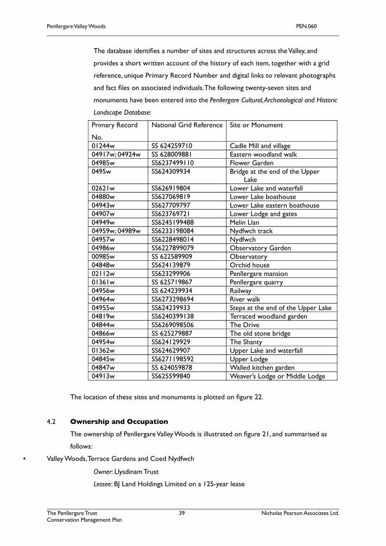
Penllergare Valley Woods PEN.060__________________________________________________________________________________________
The database identifes a number of sites and structures across the Valley, and
provides a short written account of the history of each item, together with a grid
reference, unique Primary Record Number and digital links to relevant photographs
and fact fles on associated individuals. The following twenty-seven sites and
monuments have been entered into the Penllergare Cultural, Archaeological and Historic
Landscape Database:
Primary Record
No.
National Grid Reference Site or Monument
01244w SS 624259710 Cadle Mill and village04917w; 04924w SS 628009881 Eastern woodland walk04985w SS6237499110 Flower Garden0495w SS624309934 Bridge at the end of the Upper
Lake02621w SS626919804 Lower Lake and waterfall04880w SS627069819 Lower Lake boathouse04943w SS627709797 Lower Lake eastern boathouse04907w SS623769721 Lower Lodge and gates04949w SS6245199488 Melin Llan04959w; 04989w SS6233198084 Nydfwch track04957w SS6228498014 Nydfwch 04986w SS6227899079 Observatory Garden00985w SS 622589909 Observatory04848w SS624139879 Orchid house02112w SS623299906 Penllergare mansion01361w SS 625719867 Penllergare quarry04956w SS 624239934 Railway04964w SS6273298694 River walk04955w SS624239933 Steps at the end of the Upper Lake04819w SS6240399138 Terraced woodland garden04844w SS6269098506 The Drive04866w SS 625279887 The old stone bridge04954w SS624129929 The Shanty01362w SS624629907 Upper Lake and waterfall04845w SS6271198592 Upper Lodge04847w SS 624059878 Walled kitchen garden04913w SS625599840 Weaver’s Lodge or Middle Lodge
The location of these sites and monuments is plotted on fgure 22.
4.2 Ownership and Occupation
The ownership of Penllergare Valley Woods is illustrated on fgure 21, and summarised as
follows:
• Valley Woods, Terrace Gardens and Coed Nydfwch
Owner: Llysdinam Trust
Lessee: BJ Land Holdings Limited on a 125-year lease
__________________________________________________________________________________________The Penllergare Trust 39 Nicholas Pearson Associates Ltd.Conservation Management Plan
Penllergare Valley Woods PEN.060__________________________________________________________________________________________
Since 1991, BJ Land Holdings Limited has been required to provide and maintain
Penllergare Valley Woods as a country park for public access and recreation, as part
of a Section 106 Agreement in exchange for planning permission for the Parc
Penllergaer housing development, which allowed for enabling works such as the
transit sewerage system, currently unadopted.
• The Walled Gardens and area surrounding Parc Penllergaer
Owner: Penllergaer Desmesne Land Settlement Trust, subject to a residual building
agreement in favour of Bellway Homes Wales Ltd.
Swansea City and County Council are understood to be negotiating a deed of
variation whereby the Council retains an interest in the provision of public access in
accordance with the objectives of the Penllergare Trust.
• The Civic Centre, car park and Equatorial Observatory
Owner: the City and County of Swansea.
• Upper and Middle Lodges
Owner: Private
• M4 and A48 culvert
Owner: The Highways Agency
• Overhead Power Transmission Lines
Subject to wayleaves
• Tip site east of Valley Woods
Responsibility of BJ Land Holdings Limited
• Foul Water Sewers
Responsibility of BJ Land Holdings Limited, unadopted.
4.3 Planning and Policy Context
The following section summarises the planning and policy context. More detail is provided in
the Audience Development and Access Plan.
City and County of Swansea Unitary Development Plan
Penllergare Valley Woods is covered by the following policies in the City and County of
Swansea Unitary Development Plan (due for formal adoption mid 2008):
EV6 Ancient Monuments and Protection of Archaeological Sites
The Council will seek to protect, preserve and enhance Scheduled Ancient Monuments and their
setting, and also unscheduled archaeological sites and monuments and their settings listed in the
County Sites and Monuments Record held by the Glamorgan Gwent Archaeological Trust’s Curatorial
__________________________________________________________________________________________The Penllergare Trust 40 Nicholas Pearson Associates Ltd.Conservation Management Plan
Penllergare Valley Woods PEN.060__________________________________________________________________________________________
Division. Where proposals affect sites and areas of archaeological potential, applicants will be
required to provide the following information:
i) An assessment or evaluation of the archaeological or historic importance of the site or
structure.
ii) The likely impact of development on the archaeological site, and
iii) The measures proposed to preserve, enhance and record features of archaeological
interest.
EV7 and EV8 Extensions/Alterations to Listed Buildings and Demolition of Listed Buildings
Extensions or alterations to a listed building will be supported where they safeguard the following:
i) The character of the listed building in terms of its scale, design, materials and features
which it possesses that are of special architectural or historic interest; and
ii) The historic form and structural integrity of the building.
The change of use of listed buildings will be permitted where this contributes towards the retention
of a building without having an adverse effect on its character, special interest or structural integrity.
Permission will not be granted for the total or substantial demolition of a listed building other than
where there is the strongest justifcation.
EV11 Historic Parks, Gardens and Landscapes
Development that unacceptably adversely affects the character or setting of registered Historic
Parks and Gardens or the character of Historic Landscapes will not be permitted.
EV20 New Dwellings in the Countryside and
In the countryside new dwellings will only be permitted where:
(i) The dwelling is required for people engaged in full time agricultural, forestry work or other
activities supporting the local rural economy who need to live on the premises rather
than a nearby settlement, and
(ii) There is no alternative existing dwelling available in nearby settlements and there are no existing
buildings on the farm or forestry unit suitable for conversion to residential use, and,
(iii) the proposed dwelling is located as close as possible to the existing farm buildings or forestry
complex.
EV21 Rural Development
In the countryside non residential development will only be permitted where it can be demonstrated
that:
(i) It is benefcial for the rural economy or rural employment, or
(ii) It meets the overriding social or economic needs of the local community, or
__________________________________________________________________________________________The Penllergare Trust 41 Nicholas Pearson Associates Ltd.Conservation Management Plan
Penllergare Valley Woods PEN.060__________________________________________________________________________________________
(iii) It is an appropriate development associated with farm diversifcation, sustainable tourism and
recreation, or nature conservation and does not adversely affect the viability of an established farm
unit, or
(iv) It provides an acceptable economic use for a redundant building(s) or previously developed
land, or
(v) It is essential for communications, telecommunications, other forms of utility service provision,
minerals or renewable energy generation.
Proposals for any of the above would need to demonstrate that:
(a) The development needs to be located in the countryside rather than in a nearby settlement, and
(b) The business is viable and fnancially sustainable, and
(c) The proposal is in accord with the conservation and design policies of the plan.
HC25 Lliw/Llan Valley
The further development of the Lower Lliw Valley Reservoir and Llan Valley Woods to provide for
sustainable recreation and tourism within a framework of protecting and enhancing natural heritage
and historic environment is proposed.
Details of this policy include:
The Llan Valley is an attractive steeply sloping wooded valley at Penllergaer and is in private
ownership. This area has considerable potential for recreational use, particularly as it is strategically
located in relation to the motorway. The majority of this woodland area forms part of the Penllergare
historic park and gardens and its further development for recreational purposes should respect the
character and setting of the historic park and garden as specifed within Policy EV11.
Eastern areas of the valley are covered by the following policy:
HC26 Informal Recreation
Opportunities for informal recreation in the countryside and within the urban greenspace
system will be promoted provided that:
(i) There would be no unacceptable signifcant adverse harm affect harm to the character or
appearance of the countryside or urban greenspace,
(ii) There would be no unacceptable signifcant loss of amenity to people living in the
vicinity or to the enjoyment of other countryside users,
(iii) There would be no signifcant adverse harm to sites of importance in terms of natural heritage
and the historic environment, and
(iv) Access can be provided by a choice of modes of travel, but particularly on foot, by
cycle and public transport.
__________________________________________________________________________________________The Penllergare Trust 42 Nicholas Pearson Associates Ltd.Conservation Management Plan
Penllergare Valley Woods PEN.060__________________________________________________________________________________________
Areas covered by policies HC1 (housing site for ten plus dwellings – now developed as Parc
Penllergaer) and ECI (Employment Land) lie adjacent to Penllergare Valley Woods. The area of
old parkland between the former drive and the modern boundary of Parc Penllergaer does
not appear to be covered by any policies at all. The walled garden is covered by historic park
and garden policy EV11, but has been excluded from policy HC25. Also lying adjacent to the
historic landscape are areas covered by policies EV27 (protection of SSS1s and National
Nature Reserves), and EV23 (green wedges Gorseinon and Llan Valley) which seek to protect
landscape openness and character.
People, Places, Futures - The Wales Spatial Plan (2004)
This document produced by the Welsh Assembly stresses the importance of Wales’s high
quality landscapes and how their preservation and enhancement will be increasingly important
to the long term ability of Wales to be a place where people choose to live and work.
City and County of Swansea Tourism Strategy 2006-11
The strategy identifes the potential for Swansea to become a major regional centre for
tourism, supported by the Wales Spatial Plan. It is hoped that tourism will contribute
towards the Council’s stated vision for Swansea to become one of Europe’s foremost year-
round maritime destinations for leisure and business tourism, offering a unique blend of high quality
recreational, sporting and cultural experiences in an outstanding environment. Under Area 5: M4
Corridor, Penllergare Valley Woods is identifed as a key location and site for tourism, with the
products required being Golf course and leisure resort with country park at Penllergaer (depending
on planning) and Regeneration of Penllergare Valley Woods including observatory with photographic
links. The strategy actions include Support the regeneration of Penllergare Valley Woods citing the
relevant stakeholders as The Penllergare Trust and the Countryside Council for Wales.
4.4 Wildlife Designations and Data
The ecological habitats on the site were surveyed in 2002, and a simplifed map is included as
fgure 23.
In Swansea’s City and County’s A Local Biodiversity Strategy and Action Plan (2006), Penllergare
was selected as a candidate for a Site of Interest for Nature Conservation (SINC).
The Countryside Council for Wales and the Forestry Commission have identifed Plantations
on Ancient Woodland Sites (PAWS) in the upper valley and eastern side of the lower valley.
Although there is limited historic evidence for Ancient Woodland, site evidence supports the
view that pasture woodland and ancient hedgerows (fgure 23) have contributed to the semi-
natural woodland habitats.
__________________________________________________________________________________________The Penllergare Trust 43 Nicholas Pearson Associates Ltd.Conservation Management Plan
Penllergare Valley Woods PEN.060__________________________________________________________________________________________
Habitats of principal importance for conservation of biological diversity are said to include:
Wet woodland
Wood pasture and parkland
Lowland mixed deciduous woodland
Ancient and/or species rich hedgerows
Lowland dry acid grassland
Purple moorgrass and rush pastures
Eutrophic standing waters
Plant species of special county interest include:
Wood club-rush
Wood small-reed
The sub-erect bramble
Narrow Buckler-fern
Smooth stalked Sedge
Pendulous Sedge
Species included in the Countryside Council for Wales Category A, List of Globally
Threatened Plants include Bog Asphodel and Whorled Caraway.
Penllergare is well known for its bluebells, and was once famous for daffodils. Extensive
areas of the woodlands are affected by invasive exotic weeds including Himalayan balsam,
bamboo and Rhododendron ponticum. Bracken, although native, also acts as an invasive weed
on the site. Japanese Knotweed and related species occur in isolated pockets.
Penllergare Valley Woods also provide an important transit site and reservoir of breeding
woodland birds (18). A 2001 survey identifed ffty-nine species of birds in the Valley, forty-four
of which are thought to nest in the woods. Most observed birds were the wren, robin,
wood pigeon, blackbird and chaffnch. Buzzards, red kite, greater spotted woodpecker,
sparrow-hawk, dipper, tawny owl, song thrush, kingfsher and yellow wagtail have also been
observed.
Brown trout are common, and salmon spawn upstream. The Lower Lake is said to contain
recently introduced coarse fsh.
__________________________________________________________________________________________The Penllergare Trust 44 Nicholas Pearson Associates Ltd.Conservation Management Plan

Penllergare Valley Woods PEN.060__________________________________________________________________________________________
Mammals observed include rabbit, fox, bats, grey squirrels, mink and badger. Otters and
foxes were hunted at Penllergare during the nineteenth century, and both are believed to be
present.
4.5 Access and Accessibility
Getting to Penllergare
The April 2008 visitor survey revealed that 84% of respondents travelled to Penllergare
Valley Woods by car, 10% walked and only 2% used public transport. This refects the reality
of the park, bounded on two sides by major roads which sever the site from many of its
nearest residents.
The nearest bus-stops are located at the Swansea Council offces, at the Midway Café on
the A48, and on the A483 west of Parc Penllergaer, and south of Cadle Mill (fgure 24), within
a short walk of the site boundaries. These provide the only means of convenient public
transport to the site. The nearest railway station is some distance away at Cockett. There
are no National Cycle Network routes running in close proximity to Penllergare, the nearest
located along Swansea Bay, leading up to Cockett railway station. The valley is used, however,
by local cyclists and horse riders and cycle storage is being erected next to the Council
offces for use by the staff and members of the public.
Entering the Valley Woods
There are currently three principal entrances into Penllergare and a number of subsidiary
and informal gateways (fgure 24). The northwest entrance shares the drive and car park
with the Council offces. A signposted path leads into the woods from the car park via a
kissing gate. The northeast entrance runs off a lay-by and footpath alongside the A48, and
follows a track into the woods which also provides vehicular access for forestry vehicles.
Gates and a further barrier near the top of the Upper Lake prevent unauthorised vehicular
access to the Woods. Both northern pedestrian entrances link to the wider path network
around the woods, although there is limited directional signage to welcome unfamiliar
visitors. As these entrances are linked to informal parking areas, they are the most well-used
access points, leading to a focus of public activity around the northern end of the valley. A
further principal entrance follows the original historic estate entrance, through Cadle and
past the Lower Lodge. This offers vehicular access to the Woods for authorised vehicles only.
Pedestrians can either access the Woods via the drive itself, or via a footpath off the drive
__________________________________________________________________________________________The Penllergare Trust 45 Nicholas Pearson Associates Ltd.Conservation Management Plan
Penllergare Valley Woods PEN.060__________________________________________________________________________________________
that follows the riverbank. This entrance also offers visitors a picnic site. Two additional
entrances run from Parc Penllergaer and through the eastern boundary of the site, to the
Lower Lake.
In addition to these three principal entrances, there are a number of informal pedestrian
access points including further links with Parc Penllergaer. The Trust’s proposal for a
suspended walkway through the M4/A48 culvert at the head of the truncated valley, linking
Valley Woods to Penllergaer Forest and the motorway service station, has been shelved on
the advice of Forestry Commission Wales, pending resolution of anti-social behavioural
problems in their area.
Walking around the Valley
The Valley itself is served by a network of pedestrian routes of varying quality and
accessibility. The most accessible path through Penllergare is the old drive, which is wide,
surfaced and gently sloping. Pedestrian routes through the woods are predominantly worn
mud paths or made up of rough hardcore, linked with steep sloping paths or historic stone
steps. River crossings are limited to three bridges; a metal vehicular bridge with a barrier, and
a single beam footbridge, between the Upper and Lower Lakes, and a second single beam
footbridge crossing the river below the Lower Lake. There are no benches within the
Woods, excepting a few picnic tables at the southern entrance.
Interpretation and guides for walkers is limited to a bilingual visitor leafet, a walk routes
leafet and map in English only. This map is also displayed at the three principal and one
secondary entrances.
Remote access
Additional remote access to Penllergare is provided by the well-illustrated and informative
Penllergare Trust website. From July 2007 to June 2008 the website received 13,725 hits. The
website also sells the latest publication on Penllergare’s history, Echoes from Valley Woods.
Publicly-funded studies and surveys are deposited at West Glamorgan Archive Service for
public reference. The Swansea Heritage website also provides online access to the early
historic photograph collection of Penllergare in the mid nineteenth century.
4.6 Community Involvement
In putting together Echoes from Valley Woods, The Penllergare Trust interviewed a large
number of local people and recorded their memories of Penllergare. Poetry and quotes from
__________________________________________________________________________________________The Penllergare Trust 46 Nicholas Pearson Associates Ltd.Conservation Management Plan
Penllergare Valley Woods PEN.060__________________________________________________________________________________________
local children were also sought and included in the publication, as were frst-hand
descriptions and correspondence from family and visitors over the past two centuries.
Together, these accounts reveal the strong sense of continuity and community ownership of
the site, and how Penllergare appeals to a cross section of society. Past and ongoing
involvement of the community includes the following initiatives:
Community Engagement and Education Programme
Given the lack of human and fnancial resources of the Trust at its inception, Trustees decided
to concentrate on two felds of activity: Community engagement and education (C2E);
together with gaining as much knowledge and understanding as possible about the place
through archival research and surveys to inform future restoration and management. It was
only in 2005 that suffcient funds became available to enable the Trust to take preliminary
steps in making Valley Woods a safer and more functional place for visitors.
The Trust has been running a Community Engagement and Education Programme (C2E) for
some nine years. This consists of an on-site and in-school Local Schools Programme,
involving projects with fve local primary schools; community events, primarily consisting of
guided and themed walks, and talks to outside organisations (over 160 to date), as well as an
audio history archive. The Penllergare Valley Woods Forum, representing the views of local
people and stakeholders, provides a regular link between the users and the Trust, and the
Friends of Penllergare Valley Woods. The programme is funded from 2008-2012 with a Big
Lottery People and Places award.
Friends of Penllergare Valley Woods
The Friends of Penllergare is affliated with The Penllergare Trust. The purpose of the Friends
is to raise funds, promote and support the Trust’s activities, and also provide a programme of
meetings, site visits and events, together with a specifc Friends publication and a Trust
newsletter. Members are charged a £10 annual subscription. There are currently 200
subscribers (over 300 members).
Website contributions
Community involvement is also achieved through the Trust’s website which requests any
personal archives, memories and photographs to add to their knowledge of Penllergare’s
history; and seeks suggestions and ideas for future management of the Valley, as well as views
on its current condition.
Partnerships
So far the Trust has established the following informal partnerships and relationships:
• City and County of Swansea
__________________________________________________________________________________________The Penllergare Trust 47 Nicholas Pearson Associates Ltd.Conservation Management Plan

Penllergare Valley Woods PEN.060__________________________________________________________________________________________
• The Forestry Commission
• Blaenymaes, Portmead, Penplas Development Trust Limited (BPP)
• Five local schools
• School of the Built and Natural Environment, Swansea Metropolitan University
• British Trust for Conservation Volunteers (BTCV)
• Countryside Council for Wales
• Penllergaer and Llangyfelach Community Councils
• The Gower Society
• Swansea Council for Voluntary Service
• Welsh Historic Gardens Trust
Public Consultation
Formal public consultation was carried out in Spring 2008. Key fndings of the consultation
were:
• The majority of respondents visited Penllergare 1 to 5 times a year; 17% never visited,
but supported the work of the Trust;
• 84% of visitors travelled to Penllergare by car;
• Most visitors knew about Penllergare because they were local, and had lived in the area
a long time;
• Most visitors went to Penllergare Valley Woods to walk, although many also enjoyed the
site for its wildlife, quietness and scenic beauty;
• 70% of respondents visited the Upper Valley and the Lower Valley about the same
amount, with no preference for one area;
• The favourite feature at Penllergare was the Upper Falls;
• The presence of both off-road vehicles, including quad bikes and motorcycles, as well as
burnt out, abandoned vehicles, are the main factors that put visitors off from visiting the
Valley. The fnal car wrecks were removed during the survey period;
• Trees and heritage were both cited as topics visitors would like to know more about,
with a clear demand expressed for guided walks, interpretation boards, guide books and
interpretative maps;
• Woodland management, benches and picnic areas were all popular choices for park
improvement;
• Of the respondents, 44 came from Swansea, and 10 came from further afeld. Two
respondents were disabled, and the majority were white European, retired and aged 65
or over.
__________________________________________________________________________________________The Penllergare Trust 48 Nicholas Pearson Associates Ltd.Conservation Management Plan
Penllergare Valley Woods PEN.060__________________________________________________________________________________________
4.7 Management, Maintenance and Administration
The ownership and legal status of Penllergare is quite complex, and has, in recent years, left
the responsibility for managing and maintaining the landscape in limbo. The Penllergare Trust
was established in 2000 as a registered charity and company limited by guarantee to address
this situation. Following years of neglect due to protracted negotiations about the future of
Penllergare, the Trust was set up:
• to further the protection, conservation and restoration of the cultural landscape of Penllergare.
• to protect and enhance Penllergare`s diversity of wildlife.
• to provide an oasis in the surrounding urbanisation for free, quiet enjoyment by local people
and visitors on foot.
• to promote knowledge and appreciation of Penllergare, its history and biodiversity.
• to provide sustainable training and employment (including volunteers).
The Trust comprises of fve trustees, a volunteer company secretary cum project manager,
and the salaried Head of C2E, all of whom have expertise in historic landscape management
and Penllergare’s heritage. There are six meetings a year and invitees include representatives
from The Gower Society; Blaenymaes, Portmead and Penplas Development Trust; a local
resident and user of the Valley Woods; and the County Councillor for Penllergaer ward.
The Penllergare Trust operates a de-facto management regime, with the intent of acquiring a
secure interest in the tenure of the Valley Woods in the near future. Work by the Trust to
date has included removing burnt-out cars, clearing scrub, woodland regeneration and
revealing historic stone steps. The Trust has also invested in essential infrastructure
including 14km of footpaths, kissing gates, a vehicle bridge, two footbridges, and vehicle gates
and barriers. These have helped control access into the Valley and improve the security of
Penllergare. The increasing popularity of the Valley Woods with walkers helps to improve the
security of the site by ensuring a degree of public presence, complemented by the woodland
management team and volunteer wardens from time to time.
The current administrative organisation of Penllergare is summarised below:
__________________________________________________________________________________________The Penllergare Trust 49 Nicholas Pearson Associates Ltd.Conservation Management Plan
Llysdinam (Charitable) Trust - owner
Penllergaer Demesne Land Settlement - owner
LlysdinamField Centre
Llysdinam
Gardens
Agent, Rees Richards
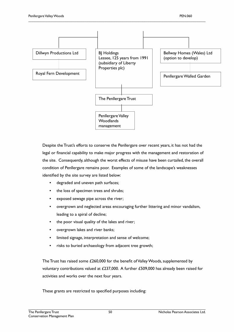
Penllergare Valley Woods PEN.060__________________________________________________________________________________________
Despite the Trust’s efforts to conserve the Penllergare over recent years, it has not had the
legal or fnancial capability to make major progress with the management and restoration of
the site. Consequently, although the worst effects of misuse have been curtailed, the overall
condition of Penllergare remains poor. Examples of some of the landscape’s weaknesses
identifed by the site survey are listed below:
• degraded and uneven path surfaces;
• the loss of specimen trees and shrubs;
• exposed sewage pipe across the river;
• overgrown and neglected areas encouraging further littering and minor vandalism,
leading to a spiral of decline;
• the poor visual quality of the lakes and river;
• overgrown lakes and river banks;
• limited signage, interpretation and sense of welcome;
• risks to buried archaeology from adjacent tree growth;
The Trust has raised some £260,000 for the beneft of Valley Woods, supplemented by
voluntary contributions valued at £237,000. A further £509,000 has already been raised for
activities and works over the next four years.
These grants are restricted to specifed purposes including:
__________________________________________________________________________________________The Penllergare Trust 50 Nicholas Pearson Associates Ltd.Conservation Management Plan
Dillwyn Productions Ltd
Royal Fern Development
BJ Holdings Lessee, 125 years from 1991 (subsidiary of Liberty Properties plc)
Bellway Homes (Wales) Ltd(option to develop)
Penllergare Walled Garden
The Penllergare Trust
Penllergare Valley Woodlands management

Penllergare Valley Woods PEN.060__________________________________________________________________________________________
C2E
A Big Lottery Fund three-year grant of £260,000 (80% of the total cost) under its People and
Places programme, towards the cost of employment of a project manager, Head of C2E, a
volunteer and training coordinator and whole-life education coordinator to achieve specifed
outcomes in health and well-being, learning and social inclusion, as well as safeguarding the
environment.
Better Woodlands for Wales
The tradition of high-quality woodland management to be revived at an initial cost of
£384,000, with a grant of £238,000 from the Forestry Commission. During 2008-12 Valley
Woods will beneft from restored Ancient Woodland, planting of new native woodlands and
improved condition and diversity of existing, neglected woodlands. Local communities will
beneft from improved access for recreation, training and employment. In the longer term,
the woodlands could become a source of revenue through sustainable harvesting. Better
Woodlands for Wales has allowed the continued employment of three full time workers,
known as the Woodland Management Team. They manage the woodland and paths, and carry
out general maintenance works, under the direction of the Trust’s volunteer project manager.
All are local residents.
Specialist works are undertaken by external contractors as necessary. Volunteer wardens
and Friends are also involved with landscape improvements and litter picking.
4.8 The River Llan
The river Llan drains a mainly rural catchment north of Swansea, which historically included
some coal pits, a large tinplate works, railway, and more recently, motorway upstream of the
site. It is part of the Loughor catchment, a typical Welsh river with steep upper catchment,
and the river fow reacts quickly to rainfall. Downstream, the river drains a more urban
landscape at Fforest-fach, before fowing into the Loughor estuary, a European Special Area
for Conservation (SAC). There is one licenced surface water abstraction within the site.
The river is said to support brown trout and salmon, and may have some value for sea trout.
Since 2001 there have been four recorded potentially polluting incidents along the river Llan:
• December 2004 Sewage leakage upstream
• September 2005 Sewage manhole discharge on site due to blockage
• February 2007 Sewage discharge 200m SW of Midway cafe
__________________________________________________________________________________________The Penllergare Trust 51 Nicholas Pearson Associates Ltd.Conservation Management Plan
Penllergare Valley Woods PEN.060__________________________________________________________________________________________
• June 2008 Siltation of the river due to upstream works
The Tawe, Loughor and Gower Catchment Abstraction Management Strategy (Environment
Agency, 2007) identifes that there is water available for abstraction on the river, including
higher levels of ‘non-consumptive’ use (provided that low fows are protected) for hydro-
power.
__________________________________________________________________________________________The Penllergare Trust 52 Nicholas Pearson Associates Ltd.Conservation Management Plan

Penllergare Valley Woods PEN.060__________________________________________________________________________________________
__________________________________________________________________________________________The Penllergare Trust 53 Nicholas Pearson Associates Ltd.Conservation Management Plan
Penllergare Valley Woods PEN.060__________________________________________________________________________________________
5.0 SIGNIFICANCE AND OBJECTIVES
This Statement of Signifcance seeks to summarise what it is that makes Penllergare Valley
Woods so important nationally and locally. On the basis of this understanding, broad
objectives are identifed to direct future management and conservation.
5.1 Statement of Signifcance
The values that contribute to the local, national and international importance of Penllergare
can be grouped under the following fve themes:
i. Historic Designed Landscape
Penllergare has been registered by Cadw on account of its partial survival as a very
important picturesque and Romantic landscape of the mid-nineteenth century created by
John Dillwyn Llewelyn, a nationally important fgure in horticulture. The unique
photographic archive, the survival of the underlying structure of the landscape, and
the ruined orchid house and walled garden are also cited as primary reasons for
registering Penllergare. Despite the neglect of recent decades, the well watered and
wooded landscape still retains the original designed qualities of magnifcence,
surprise, beauty and seclusion.
ii. Local Community Green Space
Penllergare has provided the people of Swansea and the local area with a highly
valued, informal, public open space for over a hundred years. It also forms part of a
important green wedge of countryside between the M4, A483 and the spreading
conurbation of Swansea, providing the only substantial recreational space north of
the city. This has been recognised with a blanket tree preservation order and in the
proposals of plans and strategies by the local authority to focus attention on
Penllergare and make it fully accessible as a community woodland and country park.
iii. History of Science and Technology
The activities, innovations and social network of the owners of Penllergare placed
the landscape, by association and physical intervention, at the centre of some of the
most advanced scientifc and technological developments of the nineteenth century.
• Photography; as the home of John Dillwyn Llewelyn, Penllergare played a
special role in the history of photography as the subject of some of the earliest artistic photographs,
at a time when the technology was still being refned.
• Astronomy; with its own private observatory, Penllergare became the site of
early astronomical observations, made more signifcant when combined
__________________________________________________________________________________________The Penllergare Trust 54 Nicholas Pearson Associates Ltd.Conservation Management Plan
Penllergare Valley Woods PEN.060__________________________________________________________________________________________
with the Llewelyn’s pioneering development of photography resulting in
some of the frst photographs of the moon. Today, the observatory is the
second oldest equatorial observatory in Wales.
• Physics; Penllergare was the site of the pioneering experiments in electricity,
in particular one of the frst demonstrations in the world of an electrically
propelled boat.
• Natural History; Penllergare contributed to Lewis Weston Dillwyn’s study
on the Flora and Fauna of Swansea, and his 1805 Botanists’ Guide.
• Horticulture; the passion of the Llewellyns for gardening, planting and
cultivation placed the landscape at the forefront of horticultural science,
exemplifed by the pioneering design of an orchid house that received
national coverage by the horticultural press.
• Botany; connections with some of the leading nurserymen, plant collectors
and directors of Kew gave Penllergare a link with the latest plant
introductions into the UK, in particular, newly discovered rhododendrons.
• Industry: Penllergare was the home of the Cambrian pottery works
entrepreneur, Lewis Weston Dillwyn at the time of its very highest quality
production (and subsequently with Lewis Llewelyn Dillwyn for Etruscan
ware); the landscape’s geology lent itself to mineral exploitation with clay
excavation and the later coal mining which contributed signifcantly to the
character and spread of the modern local urban landscape.
• Engineering; the creation of the lakes and waterfalls were examples of the
Victorians’ incredible drive for projects on a grand scale, built with
durability and apparent effortlessness to create a dramatic natural
landscape.
iv. Wildlife Value
Penllergare Valley Woods supports a number of natural habitats and offers visitors a
valued opportunity to observe and enjoy wildlife. Of particular importance for the
ecological signifcance of the site are veteran trees, rhos grassland, river habitats,
ancient woodland sites and adjacent SSSI.
v. Cultural Value
__________________________________________________________________________________________The Penllergare Trust 55 Nicholas Pearson Associates Ltd.Conservation Management Plan
Penllergare Valley Woods PEN.060__________________________________________________________________________________________
Penllergare remains close to the heart of many local people who have known the
Valley all their lives, and have cherished memories of the estate as expressed in
Echoes of Valley Woods. Penllergare and the Llewelyns are synonymous with charitable
and philanthropic gestures in the surrounding villages and towns including schools,
hospitals and poor houses, as well as Penllergaer church and Parc Llewelyn. The
various political roles taken by the Llewelyns of Penllergare are important to the
cultural history of Swansea.
5.2 Objectives
On the basis of the above historic analysis and statement of signifcance, the following
objectives for conservation and management are put forward for consideration:
i. as a priority, to stabilise and conserve the scheduled and other archaeology, and the
surviving historic landscape fabric of Penllergare, in situ including, earthworks, built
structures, ground levels, specimen and veteran trees, and key views;
ii. to conserve the historic character of Penllergare by the active management of the
estate, woodland and park landscape, its core features and areas, to the last signifcant
design phase, based on the best available evidence (Ordnance Survey of 1876,
photographs and written records) but subject to avoiding works which would
endanger the scheduled archaeology, or increase the impact of modern development
on the landscape;
iii. to enhance appreciation, interpretation and intellectual access to Penllergare’s
heritage, through interpretation, publications and events;
iv. to conserve and enhance biodiversity primarily through the management of the
existing landscape rather than by the creation of the new habitats;
v. to seek funding and partnerships towards conservation and management projects
consistent with coherent priorities, phasing and a programme of works;
vi. to display copies of key archival evidence and artefacts to improve public
appreciation of the site through partnerships with the Swansea Museum and West
Glamorgan Archive Service;
vii. to seek to retain and enhance protection of the Penllergare landscape through the
planning system;
viii. to improve access and welcome to the Valley for people of all abilities and increase
access to the maximum degree practicable consistent with the characteristics of the
site, and avoiding use of the private car;
__________________________________________________________________________________________The Penllergare Trust 56 Nicholas Pearson Associates Ltd.Conservation Management Plan
Penllergare Valley Woods PEN.060__________________________________________________________________________________________
ix. to improve the quality of facilities for visitors including basic refreshments, toilets,
benches, picnic tables and the provision of car parking appropriate to the use of the
site;
x. to build on the sense of community ownership, volunteer involvement and
responsibility, and minimise anti-social activity in the park;
xi. to improve the economic and environmental sustainability of Penllergare Valley
Woods, and establish a secure fnancial basis for the coherent management of the
Valley partly through increasing returns from activities;
xii. to involve people of all backgrounds and abilities in the improvements, enjoyment
and upkeep of Penllergare.
6.0 GENERAL ISSUES AND PROPOSALS
__________________________________________________________________________________________The Penllergare Trust 57 Nicholas Pearson Associates Ltd.Conservation Management Plan
Penllergare Valley Woods PEN.060__________________________________________________________________________________________
6.1 Protection of the Historic Landscape
Issues
The following issues currently threaten the survival of the historic landscape:
• Penllergare Valley Woods currently lack an owner able to invest both capital and
revenue in the protection, conservation and management of the historic landscape.
Although largely owned by a charitable trust, the majority of the area is leased to a
property company which, despite the existence of a section 106 planning agreement,
has no effective control or management, leaving the historic landscape at risk of
neglect, vandalism and misuse. It is, in effect, an extensive area of blighted urban fringe
that the unitary authority has indicated cannot be supported by care revenue
expenditure. It is currently an unsustainable public amenity and historic landscape.
• The landscape is relatively well protected from further development through the
Unitary Development Plan policies EV11 and HC25. However, still at risk are the
areas excluded from such policies, including a central area of parkland west of the
drive, near the houses of Parc Penllergaer, and the immediate setting of the landscape
outside the registered boundary, such as around Cadle to the south. The development
of Royal Fern Golf Club and housing to the east of the Valley Woods could also pose a
threat to the setting of the historic landscape, in particular, in views from the
carriageway and Graig Nydfwch Wood. The development of peripheral parts of Parc
Penllergaer has already had a serious negative visual impact on the western side of the
Valley. The observatory, and ruins of the orchid house, have statutory protection, but
the former is now marooned and in poor condition, isolated from the rest of the
landscape by the surrounding Council offce car park, while the latter is a ruin at risk
of ongoing decay and vandalism.
• Surveys by the Dyfed Archaeological Trust have gone a long way in identifying, locating
and researching component features and sites to archaeological standards. The
resulting database now guides researchers and the Trust. However, it is in a digital GIS
format, which limits accessibility for day-to-day use. The fullest possible understanding
of the site is essential for informed conservation.
Proposals
__________________________________________________________________________________________The Penllergare Trust 58 Nicholas Pearson Associates Ltd.Conservation Management Plan

Penllergare Valley Woods PEN.060__________________________________________________________________________________________
i. The Penllergare Trust, de facto occupier of the majority of the land, should seek to
acquire a secure, long term tenure of the whole surviving registered historic
landscape together with its essential setting. The surviving landscape excludes those
areas already developed for housing, Council offces and car park. Acquisition should
include the area of the walled garden, albeit that this may only be separately or
sequentially acquired, possibly by another partnership body also eligible for lottery
and public funding. This proposal, and the work of the Trust, support the objectives
of the landowner, the Llysdinam Trust, including promoting applied research,
education, and best practice in silviculture and horticulture. Furthermore,
restoration of Penllergare Valley Woods would enhance the reputation of the
landowners, and add long term value to the estate.
ii. Promote the continuing protection of the historic landscape through Local
Development Frameworks and the planning process. In particular, promote the
allocation of Section 106 funding from any future nearby developments for the
delivery of the Country Park planning consent, and promote the revision of the
Cadw Register boundary to include the one area of parkland currently within the
essential setting.
iii. Ensure that the GIS records are also available to Trust staff as hard copy and digital
reports as a basis for integrated planning and management of the site.
6.2 Physical Access to and within Penllergare
Issues
• Swansea City Council are increasing use of their offces and car park during weekdays, limiting
informal use of the car park as a means of access. Other potential parking areas at Midway Cafe and
Cadle are perceived as insecure.
• Although the Trust has erected basic signage at entrances, Penllergare suffers from a poor sense of
welcome. Consultation has also highlighted that uncertainty about whether or not access is allowed
has also discouraged visitors.
• The audience development analysis has identifed the existing and perceived diffculties of getting to
Penllergare by public transport.
• The consideration of options for visitor facilities and parking at Penllergare will determine, to some
extent, the location of primary entrances. Figure 29 illustrates the location options considered as
follows:
P1 Parking at the Midway Cafe and lay-by site.
P2 Parking in woodland adjacent P1, with direct access off the A48.
__________________________________________________________________________________________The Penllergare Trust 59 Nicholas Pearson Associates Ltd.Conservation Management Plan
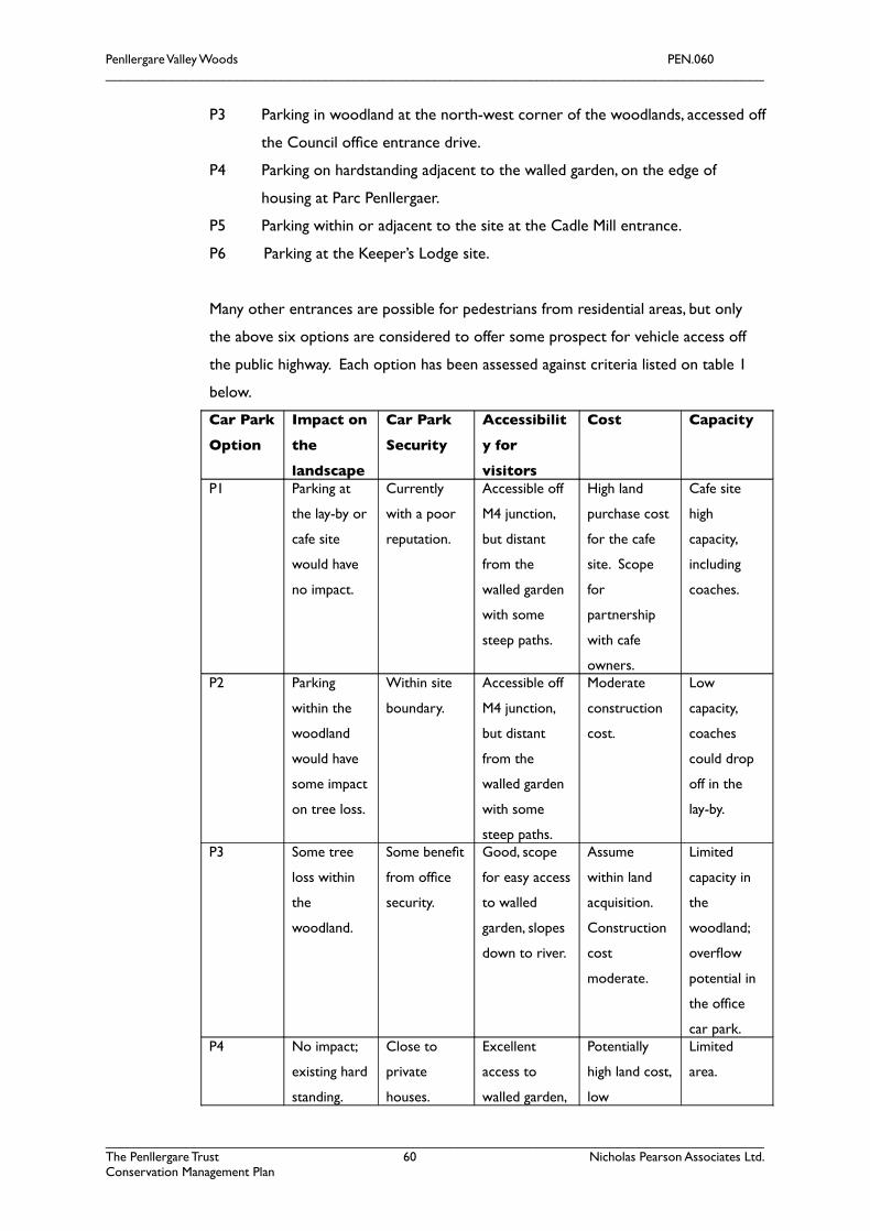
Penllergare Valley Woods PEN.060__________________________________________________________________________________________
P3 Parking in woodland at the north-west corner of the woodlands, accessed off
the Council offce entrance drive.
P4 Parking on hardstanding adjacent to the walled garden, on the edge of
housing at Parc Penllergaer.
P5 Parking within or adjacent to the site at the Cadle Mill entrance.
P6 Parking at the Keeper’s Lodge site.
Many other entrances are possible for pedestrians from residential areas, but only
the above six options are considered to offer some prospect for vehicle access off
the public highway. Each option has been assessed against criteria listed on table 1
below.
Car Park
Option
Impact on
the
landscape
Car Park
Security
Accessibilit
y for
visitors
Cost Capacity
P1 Parking at
the lay-by or
cafe site
would have
no impact.
Currently
with a poor
reputation.
Accessible off
M4 junction,
but distant
from the
walled garden
with some
steep paths.
High land
purchase cost
for the cafe
site. Scope
for
partnership
with cafe
owners.
Cafe site
high
capacity,
including
coaches.
P2 Parking
within the
woodland
would have
some impact
on tree loss.
Within site
boundary.
Accessible off
M4 junction,
but distant
from the
walled garden
with some
steep paths.
Moderate
construction
cost.
Low
capacity,
coaches
could drop
off in the
lay-by.
P3 Some tree
loss within
the
woodland.
Some beneft
from offce
security.
Good, scope
for easy access
to walled
garden, slopes
down to river.
Assume
within land
acquisition.
Construction
cost
moderate.
Limited
capacity in
the
woodland;
overfow
potential in
the offce
car park.P4 No impact;
existing hard
standing.
Close to
private
houses.
Excellent
access to
walled garden,
Potentially
high land cost,
low
Limited
area.
__________________________________________________________________________________________The Penllergare Trust 60 Nicholas Pearson Associates Ltd.Conservation Management Plan
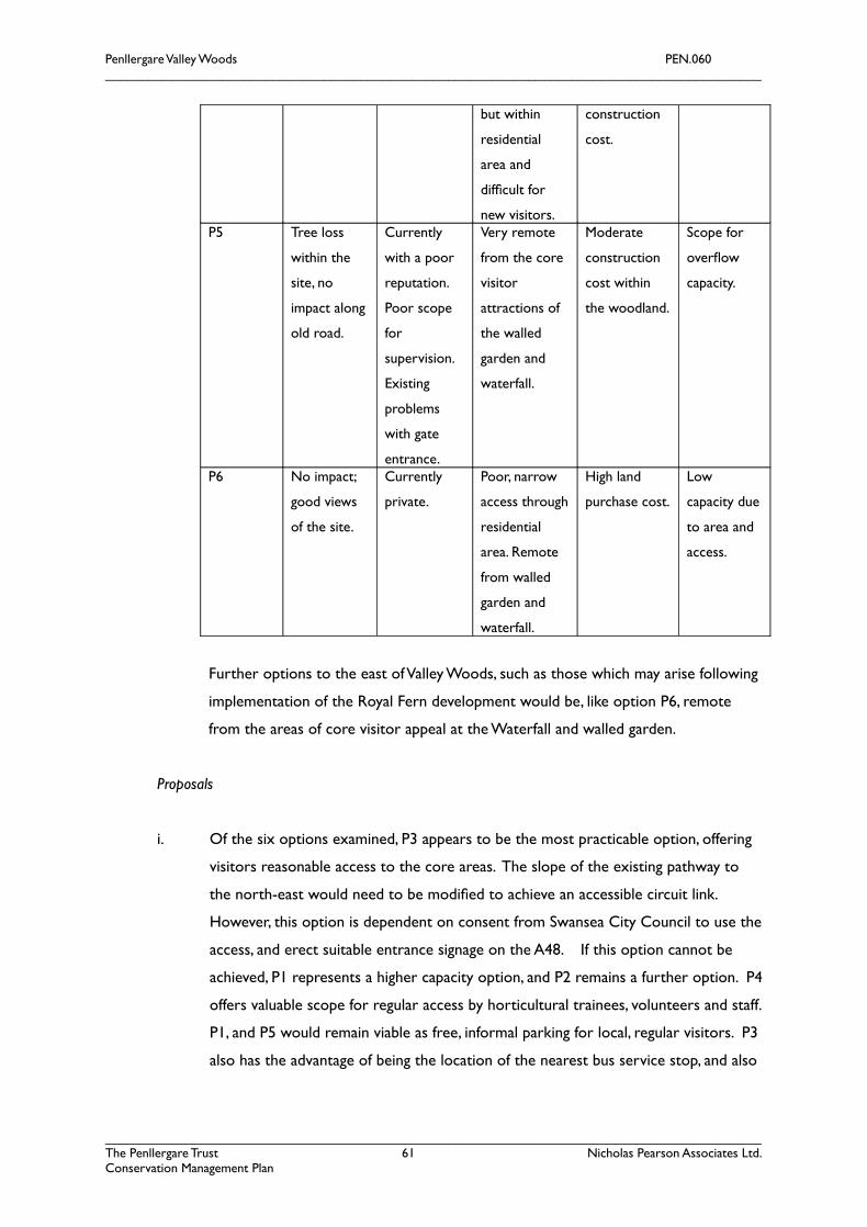
Penllergare Valley Woods PEN.060__________________________________________________________________________________________
but within
residential
area and
diffcult for
new visitors.
construction
cost.
P5 Tree loss
within the
site, no
impact along
old road.
Currently
with a poor
reputation.
Poor scope
for
supervision.
Existing
problems
with gate
entrance.
Very remote
from the core
visitor
attractions of
the walled
garden and
waterfall.
Moderate
construction
cost within
the woodland.
Scope for
overfow
capacity.
P6 No impact;
good views
of the site.
Currently
private.
Poor, narrow
access through
residential
area. Remote
from walled
garden and
waterfall.
High land
purchase cost.
Low
capacity due
to area and
access.
Further options to the east of Valley Woods, such as those which may arise following
implementation of the Royal Fern development would be, like option P6, remote
from the areas of core visitor appeal at the Waterfall and walled garden.
Proposals
i. Of the six options examined, P3 appears to be the most practicable option, offering
visitors reasonable access to the core areas. The slope of the existing pathway to
the north-east would need to be modifed to achieve an accessible circuit link.
However, this option is dependent on consent from Swansea City Council to use the
access, and erect suitable entrance signage on the A48. If this option cannot be
achieved, P1 represents a higher capacity option, and P2 remains a further option. P4
offers valuable scope for regular access by horticultural trainees, volunteers and staff.
P1, and P5 would remain viable as free, informal parking for local, regular visitors. P3
also has the advantage of being the location of the nearest bus service stop, and also
__________________________________________________________________________________________The Penllergare Trust 61 Nicholas Pearson Associates Ltd.Conservation Management Plan
Penllergare Valley Woods PEN.060__________________________________________________________________________________________
the entrance for a large ‘captive’ audience, lunchtime workers from the Council
offces.
ii. Consult with Swansea City Council to agree how overfow, weekend car parking
might be accommodated within the existing offce car park for visitors to
Penllergare.
iii. Seek to enhance public transport and cycle access links by improving the weekend
bus service, timetable labelling to include Penllergare Valley Woods, and linking to the
Sustrans National Cycle Network route 4 at Gower Way, Gowerton. Promote
sustainable transport on the website and leafets.
iv. Install improved bilingual welcome signage at every entrance.
6.3 Physical Access within Penllergare
Issues
• There is insuffcient waymarking of routes, and therefore visitors are not guided on the length and
diffculty of walks around the Valley Woods once on site.
• Occasional use by horse riders churn up paths making access diffcult for many visitors.
• Bridges essential for visitor circuits are either missing or are inaccessible for wheelchairs and
pushchairs.
• Challenging topography limits access within the woodlands, up and down the valley sides.
Proposals
i. Extend the primary stone-surfaced access circuits plotted on fgure 24, to include
access to all the main features of the landscape (including walled garden, waterfall,
and recreated Old Bridge) primarily by reinstatement of historic paths and drives.
Historic routes affected by the M4 construction will need modifcation to reinstate
gentler slopes.
ii. Recreate Old Bridge, and modify existing bridges, wherever feasible, to allow access
by wheelchairs and pushchairs.
iii. Consult further on the scope to designate a single route (the old main drive) as a
permissive cycle route only, subject to trials and acceptable conduct.
iv. Ensure accessible routes are clearly indicated on signage, leafets and more effective
waymarking around the site.
v. Investigate the feasibility of a bridle circuit, distinct from the footpath network.
__________________________________________________________________________________________The Penllergare Trust 62 Nicholas Pearson Associates Ltd.Conservation Management Plan
Penllergare Valley Woods PEN.060__________________________________________________________________________________________
vi. Ensure all site furniture (simple slab benches, fshing platforms, interpretation and
signage) meets accessibility requirements.
6.4 Interpretation, Education, Volunteers and Skills Training
Issues
More interpretation of the history of Penllergare, both social, scientifc and horticultural, has
been requested by visitors. In the light of the prevailing situation with tenure the policy of
the Trust is to limit on-site interpretation and signage to the minimum necessary for safety
and waymarking.
From its inception the Trust has operated a school programme, which has been commended
by teachers and pupils. This programme could be taken further with greater use of the
landscape as an outdoor classroom for a variety of subjects. The Trust currently works with
fve primary schools, but school visits from these are limited because:
• to maximise personal attention and in the interests of safety, only 30 children from
Year 5 and 6 only can visit at any one time;
• visits are limited to a maximum of two and half hours;
• there are no facilities, and in particular, no toilets or sheltered area to eat lunch;
• no one can provide teaching in Welsh at present;
• many schools are not able or willing to provide transport to the site.
Penllergare offers limited training opportunities at present, although the signifcant potential
for training in conservation and countryside management has been identifed. The
Association for Real Change, who promote the learning and training of people with
disabilities, is a corporate member of the Penllergare Friends group, although have yet to play
an active role at Penllergare. Training is severely limited by the lack of accommodation in the
form of a training room or other basic facilities.
Penllergare Valley Woods is used by the Swansea Metropolitan University’s School of Built
and Natural Environment, as well as Gorseinon College, both of whom are seeking greater
partnership working with the Trust.
Beyond the current volunteer project manager, the use of volunteers is limited at present
due to the need of supervision and lack of a volunteer coordinator. However, the Big
Lottery will fund full-time posts to address these defciencies. The Woodland Management
Team is readily capable of working with volunteers; the Trust estimates that the value of
contributions by volunteers was nearly £117,000 from March 2006 to March 2007.
__________________________________________________________________________________________The Penllergare Trust 63 Nicholas Pearson Associates Ltd.Conservation Management Plan
Penllergare Valley Woods PEN.060__________________________________________________________________________________________
Proposals
i. Establish organisational and interpretative links with Swansea Museum and West
Glamorgan Archive Service, which should be the deposit of choice for artefacts. For
example, the Museum are willing to lend framed historic photographs for use at
events and exhibitions. This should be expanded to link a heritage trail with other
Llewelyn sites in Swansea.
ii. Develop an interpretation plan for the site which is fully bilingual, and provides links
between publications, website and leafets, entrance signage and interpretation,
including printed guides, mobile phones audio tours and downloads, and subtle in-situ
interpretation through waymarking, carved benches and identifcation of original
photographic locations. The Safari Guide approach promoted by Land Design has
particular potential at Penllergare as a personal record of a visit encouraging active
engagement and learning by all ages.
iii. Develop and extend the current role of volunteers and trainees, with woodland
work, to embrace masonry, horticulture, stewarding, interpretation, wildlife, and
fsheries. This should be achieved by building on existing, and developing new
partnerships, for example, with BTCV who have a service level agreement with the
probation service. Training provision should also be written into the preliminaries of
any specialist contract works.
iv. Interpretation should be developed and implemented throughout the project, to
include temporary interpretation during works such as guided walks, and before and
after images.
v. Further develop education, learning, volunteer and training programmes as set out in
the Access, Audience Development and Training Plan through the Big Lottery People
and Place C2E project.
6.5 Audience Development
Issues
Only six of the ffty fve respondents to the April 2008 Have Your Say questionnaire found out
about Penllergare initially through The Trust’s outreach, education or community activities.
The Trust has intentionally kept publicity low-key during this initial period to avoid raising
__________________________________________________________________________________________The Penllergare Trust 64 Nicholas Pearson Associates Ltd.Conservation Management Plan
Penllergare Valley Woods PEN.060__________________________________________________________________________________________
public expectations and losing audience when the landscape is still in such a poor condition.
Instead, audience development to date has focussed on providing information through
publications, promotion of current restoration works and guided walks and talks, in order to
ensure that those who visit Penllergare are informed of the reasons for its current condition,
and the initiatives in place to overcome this. Leafets are available as downloads from the
website and are distributed at guided walks and talks, as well as by the woodland
management team and volunteer wardens on an opportunity basis.
The Trust is keen to extend its current C2E Programme and will do so with the assistance of
the Big Lottery funding, with particular emphasis on the following categories of potential
visitors who are currently under-represented in visitors on site:
• Locally resident adults, particularly those under 65.
• External visitors and tourists
• Children and teenagers of school age
• Single females
• Parents with toddlers
• People with disabilities
• Ethnic minorities
• Non-car owners
There is a lack of Welsh literature at present. The website is only in English, and does not
cater for Welsh language users.
Penllergare is not on a well-trodden tourist circuit, but lies alongside the M4, the major
tourist route.
The Access, Audience Development and Training Plan for Penllergare identifed an issue with
the image of Penllergare, perceived by many as a derelict site lacking investment. There was
also a general lack of awareness by local people and visitors, partly because the site has
received only limited promotion.
The Trust has yet to establish a recognisable identity, which would help with its marketing
potential and promotion. The Trust has a low-key marketing approach limited to the website,
publications, leafets, the C2E programme and features in local press.
Proposals
__________________________________________________________________________________________The Penllergare Trust 65 Nicholas Pearson Associates Ltd.Conservation Management Plan
Penllergare Valley Woods PEN.060__________________________________________________________________________________________
i. Community outreach can be achieved through a wide range of partnerships
including, for example, the Gateway Gardens Trust – a unique heritage-based charity
enabling access to the beautiful historic parks and gardens of Wales. It provides free,
tailor-made visits to wonderful gardens in Wales..., covering transport costs, admission,
special guided tours and when possible, light refreshments, for education, respite and fun!
Further proposals for audience development and community engagement are set out
in the Access, Audience Development and Training Plan.
ii. The website and marketing literature should convert progressively to a bilingual
format.
iii. For the local communities, the Trust have adopted a nomenclature of Penllergare
Valley Woods which accurately refects the character, appeal and facilities at the site, as
a community woodland. However, this does not adequately refect the second
identity of the site, as historic gardens which it is planned to open to the public.
Gardens implies a distinct set of facilities summarised as loos, brews, and views, but
including plant sales and fowers. Penllergare has to promote this double identity, or
adopt a new, inclusive and clear branding, such as Penllergare’s Secret Valley or
Penllergare: Valley, Woodland and Gardens, which could include the community
woodland, waterfall, and gardens under the one heading.
6.6 Site Furniture, Infrastructure and Security
Issues
Litter is currently collected by a volunteer warden and there are no litter bins. Dog waste
bins are provided at each of the main entrances.
There are problems with the unadopted sewage pipe, owned by BJ Holdings, which serves
the industrial estate, motorway services and Parc Penllergaer. The Trust does not wish to
take responsibility for it.
Penllergare Valley Woods has suffered from a number of acts of vandalism and anti-social
behaviour over recent years, undoubtedly encouraged by the apparent lack of upkeep and
poor condition of the landscape. The landscape once provided a secluded, unstaffed,
tempting and challenging environment inviting reckless driving by motorbikes, quad bikes,
amphibians, and car thieves, as well as arson, vandalism of structures, some graffti, fy-tipping
and general littering. The dumping of stolen and burnt-out vehicles has been a serious issue
over the last decade; however, this problem has been largely resolved through the erection of
entrance barriers, work by the police, and removal by the Trust. Direct contact is maintained
between the Trust, police, and the Council’s environmental health services.
__________________________________________________________________________________________The Penllergare Trust 66 Nicholas Pearson Associates Ltd.Conservation Management Plan
Penllergare Valley Woods PEN.060__________________________________________________________________________________________
Of the forty-fve responses to the question Does anything ever put you off visiting Valley Woods?
in the April 2008 Have Your Say questionnaire, thirty-two noted security issues including
unauthorised vehicles, burnt-out cars, fear of being alone, vandalism, fear of youngsters, and
insecure parking. Areas affected by vandalism, arson and fy tipping were also fagged up as
respondents’ least favourite areas.
Proposals
i. The key to protecting the landscape from damage appears to be to create secure
gateways and boundaries. The Trust has achieved secure gateways, but some further
work with boundaries is required.
ii. The Trust should avoid taking on the unadopted sewer.
iii. Site furniture should be limited to robust, appropriate and picturesque features,
including rustic footbridges modelled on the historic record, simple oak slab
benches, timber waymarking posts. Consideration should be given to Swansea City
Council’s standard route marking convention.
iv. Forest roads and main drives should be surfaced, compacted and cambered to a fne,
dark grit fnish to match the historic views. The Trust should continue to upgrade
waymarked footpaths, including concealed stone drainage to footpaths subject to
waterlogging.
6.7 Visitor Facilities
Issues
The Midway Café off the A48 lay-by is the only refreshment outlet within the vicinity of
Penllergare Valley Woods, and is about to be reopened. There are no visitor facilities, and no
toilets on or near the site.
The Trust have mixed views on the issue of charging for entrance to all or special areas of
the Valley Woods. In order to create viable and sustainable access to the historic landscapes,
the Trust consider that the following minimum are required:
• an education and training room for use by school visits and trainees, urgently
required to meet the Trust’s current Big Lottery Fund contract;
• basic offces for Trust staff, employed to deliver the above;
• simple toilet and refreshment facilities, to enable the Trust to promote the site
during and after conservation works and, ideally to generate income to support the
long term management costs
__________________________________________________________________________________________The Penllergare Trust 67 Nicholas Pearson Associates Ltd.Conservation Management Plan

Penllergare Valley Woods PEN.060__________________________________________________________________________________________
Six options have been considered and are illustrated in fgure 29:
V1 Acquisition of the Midway Cafe could enable the development of a large capacity
restaurant and training and learning facility, with plenty of car parking and capacity
for coach visits. It could also generate income from passing motorists.
V2 To avoid high capital acquisition costs, a new building within the north-east woodland
corner could create a similar but smaller facility, more attractive to visitors but of
high construction cost. Both options are a considerable distance from the core
features, over 500 metres from the walled garden.
V3 Acquisition of the Swansea Council staff bungalow would create immediate staff
offces and learning facilities, close to the existing car parking and within 200 metres
of the walled garden and observatory.
V4 Would require the stabilisation, repair and conversion of ruinous walled garden
buildings, including lean-to bothies and, possibly, the Gardener’s Cottage. Conversion
and repair costs would be high per square metre, but create highly attractive, if small
size, spaces. Only the Gardener’s Cottage has the potential foor area for education
use. The walled garden is over 200 metres from the car park option P3, which is
probably too far for toilet facilities.
V5 Would involve a new building in woodland at the far southern end of the site.
V6 The site of Keeper’s Lodge is understood to be a building plot on the market, which
would require a new building. Although central to the western site boundary, only
one path links the site to the main visitor circuits, and it lies 700 metres from the
walled garden, almost 1km from the waterfall.
Each option has been assessed against the following criteria:
Facilitie
s option
Impact
on
Landscap
e
Access to
Visitor
Circuits
Potential
for
income
generatio
n
Re-use of
historic/existi
ng structures
Cost Capacity
__________________________________________________________________________________________The Penllergare Trust 68 Nicholas Pearson Associates Ltd.Conservation Management Plan
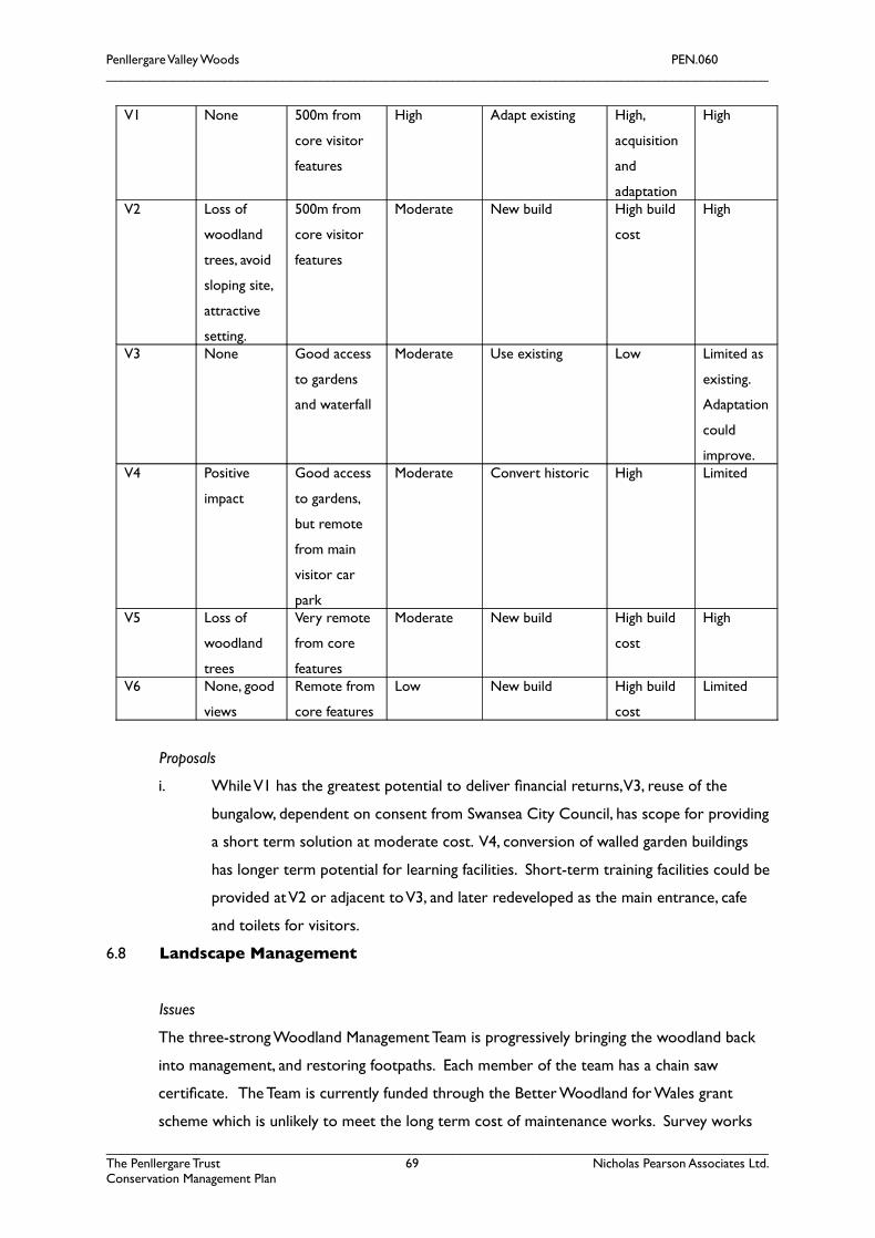
Penllergare Valley Woods PEN.060__________________________________________________________________________________________
V1 None 500m from
core visitor
features
High Adapt existing High,
acquisition
and
adaptation
High
V2 Loss of
woodland
trees, avoid
sloping site,
attractive
setting.
500m from
core visitor
features
Moderate New build High build
cost
High
V3 None Good access
to gardens
and waterfall
Moderate Use existing Low Limited as
existing.
Adaptation
could
improve.V4 Positive
impact
Good access
to gardens,
but remote
from main
visitor car
park
Moderate Convert historic High Limited
V5 Loss of
woodland
trees
Very remote
from core
features
Moderate New build High build
cost
High
V6 None, good
views
Remote from
core features
Low New build High build
cost
Limited
Proposals
i. While V1 has the greatest potential to deliver fnancial returns, V3, reuse of the
bungalow, dependent on consent from Swansea City Council, has scope for providing
a short term solution at moderate cost. V4, conversion of walled garden buildings
has longer term potential for learning facilities. Short-term training facilities could be
provided at V2 or adjacent to V3, and later redeveloped as the main entrance, cafe
and toilets for visitors.
6.8 Landscape Management
Issues
The three-strong Woodland Management Team is progressively bringing the woodland back
into management, and restoring footpaths. Each member of the team has a chain saw
certifcate. The Team is currently funded through the Better Woodland for Wales grant
scheme which is unlikely to meet the long term cost of maintenance works. Survey works
__________________________________________________________________________________________The Penllergare Trust 69 Nicholas Pearson Associates Ltd.Conservation Management Plan
Penllergare Valley Woods PEN.060__________________________________________________________________________________________
over several years have identifed key vegetation, specimen trees and shrub to be retained
and protected. The objective is to manage the landscape as recorded in 1876.
There is limited open space management, with limited areas of bracken control and periodic
arson affecting vegetation. There are no livestock on site excepting occasional strays.
Proposals
i. Identifed plantations on ancient woodland sites (PAWS) should be progressively
converted back to native woodlands by commercial thinning of conifers and
encouragement of natural regeneration, except where these coincide with the core
garden areas. Under the Better Woodland for Wales agreement.
ii. The main central area of historic parkland should be progressively thinned, fencing
reinstated, and grazing reintroduced using robust, ideally locally traditional, breeds of
cattle, managed under a Tir Gofal agreement.
iii. Areas of open ground previously woodland or plantation should be replanted using
locally native trees and shrubs following bracken control, and managed with the long
term aim of achieving continuous cover. Under the Better Woodland for Wales
agreement.
iv. Woodland open ground management, including periodic cutting or seasonal grazing
with temporary fences, should be used to retain the open character and habitats of
previous pasture woodland areas.
v. Other areas of plantations should continue to be managed, ideally under a
continuous cover regime, with a view to producing net income from woodland
management in the long term.
vi. Identify and retain veteran and specimen landscape trees to their maximum safe
biological life.
vii. Boundary fences and hedgebanks should be progressively repaired, replaced and cut
or laid as appropriate, starting with bounding livestock areas, or where there is a
history of trespass or misuse.
viii. Unsurfaced, informal footpaths should be maintained by cutting a two to four metre
swathe at least once each year, and ditches crossed using simple plank bridges with
rustic handrails. Steps, where necessary, should be stone or timber edged, wet paths
drained with a stone-edged drain.
ix. Main public circuit paths, main drives and access tracks should be maintained as
stone-surfaced tracks, with large-sized stone, reclaimed aggregate hardcore, overlaid
by fne crushed rock or grey grit free of visible wastes. Tracks should be graded,
__________________________________________________________________________________________The Penllergare Trust 70 Nicholas Pearson Associates Ltd.Conservation Management Plan

Penllergare Valley Woods PEN.060__________________________________________________________________________________________
cambered and rolled at fve year intervals, to remain substantially free of large
puddles. Verges should be fail-cut or strimmed at least once each year, two metres
wide.
x. Public access routes should be inspected annually to any hazards including potentially
dangerous trees requiring tree surgery or felling; routes may need to be diverted
away from key veteran habitat trees which cannot be made safe. Known risk areas
should be inspected more regularly.
xi. Conserve, retain and repair any surviving iron parkland railings.
xii. Manage the riverside by periodic cutting back of invasive exotic weed species within
fve metres or more of the steam, including Himalayan balsam, confrmed
Rhododendron ponticum and coppicing a proportion of young trees, to improve light
to the water and views along the river, in consultation with the Environment Agency.
6.9 Sustainability and Biodiversity
Issues
Sustainability is, in essence, about ensuring that activities today do not reduce the choices for
future generations. The following initiatives in managing Penllergare seek to improve
sustainability:
• improve the quality of the local environment, reducing the incentive to
travel further afeld
• increase the capacity for pedestrian and cycle access to the Valley
Woods
• facilitate the use of public transport to visit the site
• recycle garden wastes through composting
• minimise waste arising from visitor facilities
• minimise the use of noxiously treated timbers
• encourage the use of local produce
• use hardy plant stock of local provenance
• minimise the use of inorganic fertilisers and pesticides
• select long-lasting products for hard landscape features
• adopt energy conservation measures as part of any building refurbishment works and
the preferential use of renewable energy and fuel.
• wherever feasible, surface water drainage will be fed into groundwater
• protect and enhance biodiversity
__________________________________________________________________________________________The Penllergare Trust 71 Nicholas Pearson Associates Ltd.Conservation Management Plan
Penllergare Valley Woods PEN.060__________________________________________________________________________________________
Biodiversity is addressed specifcally through the grassland and woodland management
proposals, compliance with the law regarding protected species, together with the creation
of new woodland areas. Further ecological surveys are outstanding. Peat is not required for
use on the site, and peat-free plant suppliers would be selected. Herbicide use would be
carefully managed, and minimised by the use of mulches produced on site.
Proposals
i. As part of the detail design stage carry out a protected species survey of areas
affected by works.
ii. Investigate the potential for hydropower as part of the upper lake restoration works.
iii. Review the potential for links to the Swansea Sustainability Trail via websites, the
green map and leafet.
iv. Carry out bat, invertebrate, lower plant and riparian zone surveys.
6.10 Procurement, Project Management and Programme
Issues
Project and management works need to be completed in ways which are demonstrably cost
effective, yet also contribute to skills training, volunteer and other objectives, including
building local skills and capabilities.
Key risk areas for the management of the project and site include:
• the need to grow community support and engagement
• the need to win the confdence and support of local agencies and partners, Swansea City Council,
existing and neighbouring property owners
• arson, theft, vandalism, fytipping and antisocial behaviour
• technical challenges with, and cost estimation of, structural masonry, glasshouse, hydropower, lake
works and desilting and potential wildlife issues
• the need or the acquisition of land rights
• lack of underlying revenue funding
Proposals
i. Close site supervision and controls should continue to be developed by retention of
the Woodland Management Team, and addition of skilled head gardener, to manage
and monitor works on site, reporting to an experienced project manager. As much
__________________________________________________________________________________________The Penllergare Trust 72 Nicholas Pearson Associates Ltd.Conservation Management Plan
Penllergare Valley Woods PEN.060__________________________________________________________________________________________
as possible of the works should be carried out by employed staff, trainees and
volunteers.
ii. As agreed with the Big Lottery, skills training, volunteer involvement and community
engagement should build on the planned C2E team by building partnerships with
specialist training, volunteer and learning social enterprises.
iii. Specialist consultants and contractors should be employed for technically challenging
works, but with contract preliminaries requiring training, volunteer and community
engagement.
iv. The Trust will need to continue to build confdence and capability by adopting
progressively more challenging projects, ensuring that each phase addresses both
urgent conservation needs and community engagement.
v. The Trust will also need to develop project priorities in response to opportunities to
secure land rights, as and when they arise.
vi. Sustain the Penllergare Forum as a mechanism for local community consultation, but
also seek to establish formal, regular liaison with Swansea Council.
6.11 Income Sources
Issues
Given that the Trust will be seeking to acquire land rights with limited speculative or
productive value, the scope for income generation will be necessarily constrained. It is only
through the work of the Trust to open up, restore and promote the landscape that limited
opportunities may arise.
The potential to generate revenue from the site is limited by its nature, planning
designations, and the Trust’s own charitable purposes, including:
• to further the protection... of Penllergare
• to provide an oasis in the surrounding urbanisation for free, quiet enjoyment by local people
and visitors on foot....
Consideration of a paid entry area has been excluded for the present time following
consideration of the options with Trustees and the Penllergare Forum. In particular:
• local people have gained free access to virtually all parts of the site without restraint for many years
• the primary users are, at present, local residents familiar with the recent history of the site
• the waterfalls, which are a key feature for potential future visitors, are also a primary area for public
access at present
• the creation of a pay barrier around the garden areas would be diffcult to control and impact upon
the essentially Romantic character of the landscape
__________________________________________________________________________________________The Penllergare Trust 73 Nicholas Pearson Associates Ltd.Conservation Management Plan

Penllergare Valley Woods PEN.060__________________________________________________________________________________________
• the potential for charging for access to the walled gardens, the only area already defned by
potentially secure boundaries, is probably limited in value. A comparable exercise at Lydiard Country
Park, Swindon, charges only £1.80 per head, with free parking and good quality facilities.
It is understood that the section 106 planning agreement for the funding and management of
the Country Park has proved not to be workable, and that the City and County of Swansea
are not prepared to take on the substantial fnancial liability. As a basic minimum, this liability
is considered to include:
• a basic woodland management budget to periodically regenerate uneconomic
woodlands
• annual safety inspections and works to the main public access routes and structures
• maintenance of listed and curtilage structures and scheduled monuments
• maintenance of secure boundaries and gateways
• statutory duties for control of weeds and pests
• removal of fy-tipped wastes
• Quarry Act obligations
• insurance premiums
• minimum administrative costs
The estimated costs associated with these elements are considered to be in the region of
£100,000 per annum, identifying this as the minimum nett revenue target. These
maintenance activities could be achieved by a mixed team of employed staff, volunteers,
trainees and specialist contractors.
Proposals
i. It is proposed to meet these costs using a wide range of sources to reduce exposure
of the Trust to individual, specifc risks. Each source is likely to be individually
modest, but should include:
• Seeking a Tir Gofal agreement for Middle Park, say, £500 p.a.
• Better Woodlands for Wales long term woodland management grant for works to sustain the
community woodland, say, £2000 p.a.
• Timber sales from productive woodland management, say, average 400m³ p.a. sold standing at £10/m³.
• Parking charges for visitors using the Trust’s own car park, say, £2 each for 10,000 cars p.a.
• Hydropower electricity sales, nett of maintenance costs, say, £10,000 p.a. (see appendix 6)
• Refreshment and shop sales from modest visitor facilities, say, £20,000 p.a.
__________________________________________________________________________________________The Penllergare Trust 74 Nicholas Pearson Associates Ltd.Conservation Management Plan
Penllergare Valley Woods PEN.060__________________________________________________________________________________________
• Added value woodland craft produce, frewood, plant and produce sales from volunteer and training
activities, say, £5,000 p.a.
• Marquee pitches, location fees and commercial events, with a target of three events p.a. at £2,000
each.
• The value of volunteer activity, primarily adding value to the minimum maintenance levels, but
contributing towards some of the basic requirements.
• Fees charged for horticultural, woodland and environmental training sessions and facilities.
The latter proposal is potentially important as a means of securing long term
fnancial support from the Unitary Authority, health trusts and others in return for
specialised services which may include a Forest School, horticultural therapy and
similar activities. Two strategic options exist. Either to deliver training services
primarily through partnerships with others, with fees relating purely to the provision
of built facilities, basic administration and support; or to take on specialised services
directly, employing skilled staff to deliver the full service. The latter option is
considered to fall beyond the balanced approach implied by the Penllergare Trust’s
charitable purposes, and therefore it is proposed that the Trust should seek to
develop formal partnerships with specialist organisations which have complementary
objectives.
ii. Following a substantial period of investment during the conservation and restoration
works, the Trust will need to ensure that many events and activities are self funding,
or generate small surpluses. Potential sources of minor net revenue, additional to
the major sources listed above, include:
• bushcraft and greenwood courses
• fshing permits
• education fees and overhead charges
• commercial horticultural and woodland training sessions
• orienteering fees
• mobile phone interpretation call charges
iii. During the project development stage, prior to formal site acquisition, prepare a
detailed, business plan to demonstrate management, maintenance and viability of the
site in the short and long term.
__________________________________________________________________________________________The Penllergare Trust 75 Nicholas Pearson Associates Ltd.Conservation Management Plan

Penllergare Valley Woods PEN.060__________________________________________________________________________________________
__________________________________________________________________________________________The Penllergare Trust 76 Nicholas Pearson Associates Ltd.Conservation Management Plan
Penllergare Valley Woods PEN.060__________________________________________________________________________________________
7.0 AREA PROPOSALS
The following section outlines restoration, management and development proposals for
individual areas of the site, as subdivided on fgure 26. Proposals are also illustrated on the
Masterplan, appendix 8.
7.1 Council Offces
History
The site of the early eighteenth century house of the Price family. A small parkland was
mapped around the house by 1813 with thick perimeter tree belt and approach drives from
the west and north. The house and park were extended by 1830, with realignment of
approach drives and local public roads, with extensive renovation and rebuilding of the
mansion in 1836, and further drives, parkland and outbuildings to the north of the house
plotted in 1838. Equatorial Observatory and new northwest wing of the house built by
1876; further alterations to the layout of the gardens north and south of the observatory
were carried out between 1898 and 1916. The house and grounds purchased by the Bible
College in 1940; requisitioned by the army during World War Two; sold to Glamorgan
County Council by 1954; house and outbuildings demolished in 1961, except for the
Equatorial Observatory. The site and Observatory were sold to Lliw Valley Borough Council
in 1977. Civic Centre, car parks and new entrance drive from A48 built and laid out by 1981.
Condition
Civic Centre now Swansea City and County Council offces. The Equatorial Observatory is a
Scheduled Ancient Monument but is in poor condition with evidence of damp penetration.
A single storey unused staff bungalow lies east of the offce block. The land to the northwest
is well wooded and bound to the north by the A48 and junction 47 of the M4, and to the
west by the A483. New housing has been developed to the south. Limited, peripheral areas
of the nineteenth century gardens or parkland remain undisturbed but overgrown, and the
Observatory is the only surviving built structure. The whole area remains under the
ownership of the Council and is included with the registered landscape.
Proposals
i. Seek an agreement for occasional, event or overfow use of the offce car park and
vehicular entrance for access to the Valley Woods.
ii. Seek an agreement to enable the improved maintenance and interpretation of the
Equatorial Observatory. Seek to reuse the Observatory for interpretation and
education.
__________________________________________________________________________________________The Penllergare Trust 77 Nicholas Pearson Associates Ltd.Conservation Management Plan
Penllergare Valley Woods PEN.060__________________________________________________________________________________________
iii. Seek to acquire the disused single storey staff bungalow and its immediate vicinity
for the development of a short term Penllergare Valley Woods training and education
room, and Trust offces. If this is unsuccessful, an alternative short term site will be
required for the same purposes.
iv. Secure the boundary between the Valley Woods and the offce car park to control
informal access and fy-tipping.
v. Present information on the history of the house and grounds through interpretation
and periodic tours for staff working in the offces.
vi. Ensure that Council staff are informed about events, activities and attractions within
the Valley Woods, and encourage regular access and participation perhaps including
lunchbreak and after-hours volunteer and team building activities.
vii. If training, Trust offce and, possibly, education activity can be accommodated within
re-used and restored walled garden buildings, seek to re-use and redevelop the
short term facilities for visitor interpretation, toilets, cafe, craft and plant sales, to
support the work of the Trust.
7.2 Upper Lake and Terraced Gardens
History
Woodland plotted to the west of the river in 1813 and on both sides by 1830, some on the
eastern side being designated as Plantation on Ancient Woodland Sites (PAWS). Flower
garden at the top of the western valley side recorded in tithe apportionment and old mill,
old bridge and rapids plotted along the river in 1838. Formal gardens in place by 1840s.
River dammed and Upper Lake and falls formed shortly afterwards, known as Fish Pond by
1876. Terraced gardens with linking steps, circuit paths, lakeside walks, footbridges, a narrow
gauge novelty railway, boat house and The Shanty also all in place by 1876; the old mill had
been demolished. Boat house and The Shanty removed by 1898. Some silting up of the lake
indicated in 1916 together with a new structure in the woodland to the northeast of the
house and some minor realignment of the valley walks. Considerable silting of the Upper
Lake by 1936, with almost the entire area plotted as marshland; northern tip of the valley cut
off from the rest of the landscape through the realignment of the A48, to accommodate the
M4 motorway. Western side of the valley shown substantially cleared of woodland in 1946.
Condition
The area retains a number of striking historic landscape features including the Upper Falls,
stone steps between drystone terrace walls, original paths and some original planting. Many
paths are in poor condition or with limited accessibility, especially on the western side of the
valley. The lake remains silted with diminishing areas of open water. Some repair work took
__________________________________________________________________________________________The Penllergare Trust 78 Nicholas Pearson Associates Ltd.Conservation Management Plan
Penllergare Valley Woods PEN.060__________________________________________________________________________________________
place on the Falls during the 1990s, and these remain a prime attraction for local visitors. An
upstream gabion weir was also installed forming the new northern edge of the lake. The old
stone bridge has been demolished and replaced with a sewage pipe and wooden decked
bridge; the wooden bridge has been vandalised leaving it impassable. This area forms one of
most well visited parts of the Valley Woods, due to proximity to public transport and car
parks, and the attraction of cleared and restored historic features, in particular the Falls. The
whole area is owned by the Llysdinam Trust, leased to BJ Holdings, and lies within the
registered landscape.
Proposals
i. Survey the lake and potential silt deposition areas to confrm volumes and landform
capacity; sensitive wildlife features needing to be protected, recreated or mitigated
for; and detail measures required for the works. Secure land drainage and other
consents as necessary including waste registration exemption.
ii. Survey and record the Falls and dam structures to prepare detailed masonry,
engineering and landscape schedules of repair and consolidation.
iii. Clear trees and coppice bankside vegetation growing on the Upper Lake and restore
the lower three quarters of the lake to its 1876 form and character by the
excavation and removal of circa 18000m³ of silt to a downstream deposition area, a
kilometre distant, enabling an open bracken area to be restored as species-rich wet
grazing pasture, part of the parkland. Clear the lake up to the upstream gabion weir,
and reuse this for future silt trap management.
iv. Repair the fabric and character of the Falls to original functioning condition.
Remove graffti.
v. Replant woodland east of the lake informed by historic views and stump evidence,
predominantly native oak woodland.
vi. Install a low head hydropower Archimedes screw generator largely concealed within
the earth bank east of the Falls, controlled to avoid reduction of water fows over
the Falls during low fow period. Adopt a hydraulic offtake to reduce visual impact at
the dam top level, if necessary. Install view plates, interpretation board and power
generation gauge built into the generator house door, largely built into the hillside.
Sell power generated to the Council offces, business park or national grid, within
250 metres. See attached feasibility study (appendix 6) which indicates a modest
annual income. Basic maintenance would be carried out by Trust staff, with annual
inspections.
__________________________________________________________________________________________The Penllergare Trust 79 Nicholas Pearson Associates Ltd.Conservation Management Plan
Penllergare Valley Woods PEN.060__________________________________________________________________________________________
vii. Recreate the Old Bridge in traditional stone construction, to resemble the original as
closely as possible, to form a key fully accessible part of the pedestrian circuit, also
incorporating and concealing the sewage pipe.
viii. Restore and where necessary, reset stone steps of this historic nineteenth century
path network, either side of the Upper Lake, and improve safe access where
essential with the installation of rustic wooden handrails to the east, and wrought
iron to the more formal routes to the west.
ix. Record and repair the drystone retaining walls, in particular those along the length
of the drive.
x. Reinstate the rustic cleft oak fence along the top of the drive retaining wall.
xi. Selectively thin woodland to favour veteran and specimen trees and shrubs, coppice
laurel and clear confrmed Rhododendron ponticum. Propagate specimens present, or
in the historic record, on the site, and replant to recreate a high quality woodland
garden, albeit without fne lawns and annual bedding recorded in specifc areas of the
gardens.
xii. Survey, record and reopen key designed views and vistas.
xiii. Reopen the main historic path routes, retaining as much original fabric as possible,
restoring a fne, self-binding gravel or grit surface, as the primary visitor circulation
routes.
xiv. Modify the modern access tracks and barriers over the A48 river tunnel to create
more accessible pedestrian and maintenance access.
xv. In cooperation with the Highways Agency and Forestry Commission Wales consider
a pedestrian link to the north of the M4, using an underpass walkway.
7.3 Cae Pant
History
Apparently part of the parkland around Penllergare house in 1830 and recorded as an
enclosure called Cae Pant in 1838 with a plantation in the southeastern corner. Mature
parkland trees plotted in 1876, an area incorporating an extension of the pleasure grounds
from the north containing a perimeter walk, shrubberies and a circular seat or
summerhouse. East-west boundary indicated by 1916; remained part of the designed
landscape setting of the house in 1946.
Condition
Although overgrown with trees and shrubs, this appears to be a small, intact fragment of the
landscape with rhododendrons and azaleas, and a few specimen trees including a very fne,
mature Monkey Puzzle tree. Archaeologists have identifed the terrace of an old road
running 4m above and parallel to the main drive, which then appears to have been used as a
__________________________________________________________________________________________The Penllergare Trust 80 Nicholas Pearson Associates Ltd.Conservation Management Plan
Penllergare Valley Woods PEN.060__________________________________________________________________________________________
footpath lined with rhododendrons. Earthworks of other paths have also been identifed. A
modern path provides a route into the landscape from the adjacent housing estate. The area
is owned by the Penllergare Demesne Lands Settlement and is included within the registered
landscape.
Proposals
i. Selectively thin trees and scrub to reopen a central part of the former parkland and
pleasure grounds to create a gently sloping access route between the main drive and
the Walled Garden, reopening the historic path. Manage the open area as lawn.
ii. Identify the surviving ornamental shrubs, including rhododendrons, and consider the
scope for propagation and planting elsewhere in the gardens.
iii. Retain a dense woodland belt alongside residential boundaries and the Council
offces adjacent.
7.4 The Walled Gardens
History
First plotted in 1830, and shown again in 1838 with a southern extension. First mention of
an orchid house in 1836; orchid house improved in 1843. Garden paths, glasshouses,
horticultural buildings, fruit trees recorded in detail in 1876, together with a slip garden to
the east with pool and glasshouse, and plantation and open ground with kennels to the
south. Glasshouse extensions and gardener’s cottage built by 1898. New link path from the
walled garden to a path around quarry laid out before 1916; walled garden used as a
commercial nursery during the 1920s; and additional glasshouse erected alongside the
gardener’s cottage by 1936.
Condition
The walled garden and slip gardens are now ruinous and overgrown, with some vandalism
and fy-tipping. The garden walls themselves are in good condition in places, but have been
breached or are compromised by tree growth in others. Lean-to bothies and other
horticultural structures as well as the Gardener’s Cottage are also abandoned and in a
ruinous condition. Surviving historic infrastructure includes iron railings and gate, rusting hot
wall boiler and pipes, path edging, nails for wall trained plants, and some fruit trees and
camellias. The feld once containing the kennels has been developed with housing, and the
remaining plot of land around the Gardener’s Cottage survives as coarse grassland. An area
of hardstanding remains to the east of the Gardener’s Cottage left over from the
development of the adjacent housing estate, a path runs past this area, providing informal
pedestrian access from the housing estate into the Valley Woods. The area is owned by the
__________________________________________________________________________________________The Penllergare Trust 81 Nicholas Pearson Associates Ltd.Conservation Management Plan
Penllergare Valley Woods PEN.060__________________________________________________________________________________________
Penllergare Demesne Lands Settlement and is included within the registered landscape,
which also incorporates the site of the kennel feld, now housing. The ruined orchid house is
a Scheduled Ancient Monument. Dyfed Archaeological Trust has made a survey of the
walled garden.
Proposals
i. Seek to acquire and restore the walled garden area and ruined structures as a
horticultural training area, with restoration and high quality cultivation of the walled
garden following the historic layout, conserving surviving historic features including
the orchid house, dipping pool and path edging. Horticultural use of walled gardens
is considered to be the only appropriate setting to the Scheduled Ancient
Monument, the orchid house. Horticultural restoration and management should be
carried out under the control of a working head gardener, directing teams of
volunteers, trainees, Friends and community groups. The National Trust’s walled
gardens at Llanerchaeron and Knightshayes are managed on a similar basis. It is
anticipated that cultivation could, so far as is now practicable and permissible, echo
Victorian techniques, as well as meeting local training and community objectives.
Cropping may vary from year-to-year, according to the availability and skills levels of
trainees and volunteers, with unused areas laid to grass and, possibly, larger areas of
conventional vegetables grown organically. The reconstructed peach house, for
example, might be used to grow organic tomatoes. However, whatever is grown
should be set out within the historic layout, paths and structures of the historic
walled garden. It is not proposed that the walled garden should be managed on a
commercial basis.
ii. Survey the condition of the walls and structures and carry out stabilisation and
conservation works as a frst stage, clearing the walls of ivy and other invasive
vegetation.
iii. Secure the boundary of the walled garden to reduce informal access and discourage
anti-social behaviour, but open on a daily basis as an attraction for visitors to
Penllergare, and sell surplus produce. A small entrance fee could be charged but is
unlikely to be economic to operate. However, selected lawn areas of the gardens
could be used for community events and, occasionally, let as a marquee pitch for
functions.
iv. Seek progressive and phased restoration of the horticultural buildings, informed by
conservation statements for each element. It is unlikely to be feasible to reinstate
the full, working Victorian structures, and priorities should be informed by
signifcance, potential viability and condition. For example, as and when the walled
__________________________________________________________________________________________The Penllergare Trust 82 Nicholas Pearson Associates Ltd.Conservation Management Plan
Penllergare Valley Woods PEN.060__________________________________________________________________________________________
gardens are adequately secure, seek scheduled monument consent to reinstate the
orchid house, retaining all surviving fabric, as an act of interpretation, using the
historic record, contextual information and in situ evidence to inform an accurate
restoration. Heating could be provided using solar panels, electricity, bottled gas or
other fuel to avoid impact upon the original coal-fred components which should be
retained.
v. Where restoration cannot be justifed, some of the peripheral structures should be
conserved and then reused by the addition of entirely reversible conversions to
provide for horticultural training or associated uses, such as equipment and material
storage, volunteers’ mess room, gardens offce, craft shelter, compost toilet,
interpretation and education.
vi. Structural replanting of the garden including wall-trained fruit should utilise varieties
known at, or available to, the mid nineteenth century gardeners of Penllergare.
vii. Seek to restore the Gardener’s Cottage as an education and training room o the
ground foor, with gardener’s fat over.
viii. The large, southern, slip garden to the walled garden could be fenced off and reused
as a community orchard or vegetable allotments, to meet local demands.
7.5 The Quarry and Upper Lodge
History
Upper Lodge clearly recorded by 1838. Quarry photographed in 1856 and illustrated with a
summerhouse in 1864, but not clearly mapped until 1876, when surrounded by coniferous
woodland, a circuit path around the quarry linking the drive and walled garden, and with a
small structure high up in the northwest corner (presumed to be the summerhouse). Upper
Lodge photographed 1852, plotted with a small, enclosed garden by 1876, altered again by
1898. Summerhouse removed by 1898 and quarry referred to as Old Quarry. Quarry
plantation extended by 1916 and cleared by 1936 leaving rough grassland and mature trees
along the drive and within the quarry itself only. Scrub and grassland in 1946.
Condition
The Upper Lodge has been demolished, although the ruins of wall footing and foundations
survive. The rock faces of the quarry are partially overgrown and wooded, and the remains
of a waterfall survive in the top northwest corner, near the site of the earlier summerhouse.
The surrounding vegetation is a mixture of deciduous woodland and scrub. An informal
footpath runs from the adjacent housing to the Valley Woods with recently erected bollards
to restrict access to pedestrians only. The Quarry and adjacent woodland is owned by the
__________________________________________________________________________________________The Penllergare Trust 83 Nicholas Pearson Associates Ltd.Conservation Management Plan

Penllergare Valley Woods PEN.060__________________________________________________________________________________________
Penllergare Demesne Lands Settlement. The ruin of the Upper Lodge and its immediate
vicinity is in private ownership. Both fall within the registered landscape boundary.
Proposals
i. Thin out trees and vegetation within and on the quarry walls, carefully retaining its
picturesque and dramatic historic character.
ii. While it will not be possible to restore the waterfall due to the loss of the Home
Farm pond which supplied it, investigate the potential for tapping suspected sub-
surface water-courses, withholding and slow release of storm water in the open
drain, to extend the life of the waterfall effect, with potential for release of stored
water during events.
iii. Provide an accessible path surface into the quarry, and a secure route around the
quarry.
iv. Seek to acquire the ruins and site of the Upper Lodge to allow for integrated
management and prevent new development. Conserve the ruins and provide basic
interpretation.
7.6 Eastern Valley Woods
History
Farmland in 1813; some clumps and belt plantations planted on the valley slope by 1830.
Partly Wood on east of carriageway in 1838 and partly farmland and meadow. Increasingly
wooded by 1876 and 1898, but retaining farmland to the northeast and southeast, east of the
Lower Lake. Larger number of tracks and access routes through plantations by 1916,
suggesting increased use for commercial forestry; Tir-donkin Colliery also established by this
date on the eastern boundary of the area. The area remained a mix of woodland, scrub and
open farmland by 1936 and 1946, with the northern boundary imposed with the realignment
of the A48.
Condition
The Eastern Valley Woods remain a patchy mix of scrub, conifer plantation (partially
designated as Plantation on Ancient Woodland Site), deciduous woodland and some open
grassland areas. Some historic paths remain as earthworks or still in use. Relict veteran
pollard oaks in conifer plantations retain evidence of attempts to ring girdle, a discredited
form of weeding young plantations. An access track for forestry vehicles runs from the
northeast corner of the woodlands from the A48, and along the line of a sewer pipe. Apart
from a small area of land belonging to the Dillwyn Settlement, the whole area is owned by
__________________________________________________________________________________________The Penllergare Trust 84 Nicholas Pearson Associates Ltd.Conservation Management Plan

Penllergare Valley Woods PEN.060__________________________________________________________________________________________
the Llysdinam Trust. The area is split between lying within the registered landscape, and lying
within the essential setting of the registered landscape.
Proposals
i. Improve accessibility over the Sapper bridge, and improve the local landscape quality,
by constructing a timber or a stone-clad bridge to encase the sewer pipe. Install
collapsible bollards to limit vehicle access, but retain a 3.0m wide bridge to allow for
5 tonne estate maintenance traffc. Divert the riverside path around the bridge
piers.
ii. Improve accessibility of the riverside path leading down to the Lower Lake.
iii. Increase the sense of welcome at the Midway Café lay-by entrance with improved
signage and interpretation.
iv. Manage as partly ornamental, community woodland, retaining historic landscape
character, fabric and archaeology.
v. Reinstate natural characteristics to engineered drainage structures, in particular, the
concrete slab-lined shute below the quarry, by the removal of modern materials and
allowing natural percolation through the strata, as was previously the case.
7.7 Middle Lodge Park
History
Farmland in 1813; some tree planting indicated by 1830. Known as park west of carriageway
and park east of carriageway in 1838, with wood in park. Remained as informal parkland with
mature specimen trees in 1876; shown as half parkland and half rough grassland in 1898 with
the two areas subdivided by a fence by 1916, with a further fence subdividing the park west
of the drive. This latter boundary was straightened and realigned once again by 1936, with a
further upstanding boundary erected along the western side of the drive. Treeless open
grassland by 1946, with the adjacent rough grassland grown over with scrub.
Condition
Part of the park west of the drive has been developed with housing leaving a belt of
grassland with a line of visually intrusive modern houses on the horizon. The drive provides
a level hard surfaced route for pedestrians, and maintenance vehicles. East of the drive, the
vegetation consists of bracken, rough grassland, scrub and woodland, with views across the
valley and to the hills beyond. The remaining parkland between the housing and the drive
belongs to the Penllergare Demesne Lands Settlement, and does not currently fall within the
registered boundary but is considered part of the essential setting of the landscape. The land
to the east of the drive belongs to the Llysdinam Trust.
__________________________________________________________________________________________The Penllergare Trust 85 Nicholas Pearson Associates Ltd.Conservation Management Plan

Penllergare Valley Woods PEN.060__________________________________________________________________________________________
Proposals
i. Seek to acquire and restore both sides of the drive as landscape parkland with
topped grassland and open-grown parkland trees. Secure the boundary of the area
and reintroduce grazing with cattle grids or locked gates on the drive and kissing
gates at all pedestrian entrances and pathways.
ii. Replant parkland trees and clumps at a greater density, offset and parallel to the
western boundary of the park to create a parkland character setting to the adjacent
housing.
iii. Reopen views to the east by thinning trees and scrub, to favour oak parkland trees.
iv. Seek to acquire the ruins and site of the Middle Lodge to allow for integrated
management and prevent new development. Conserve the ruins and provide basic
interpretation. In the longer term, the foundation plinth would provide an attractive
viewpoint and site for a sheltered seat, halfway along the main drive.
v. Use part of the bracken-dominated burnt-over area as a silt deposition area for silt
from the Upper Lake, to improve agricultural pasture and wildlife values.
7.8 Lower Lake
History
Recorded as Meadow for new fshpond in 1838, and lying alongside other meadow and
farmland. River dammed to create Lower Lake, flled in 1839; by 1876 with boathouse,
cascade and islands. Some silting around the lake edges indicated in 1898. Second
boathouse built on the dam by 1936. Remained a large body of water in 1946, although area
around northern inlets were becoming increasingly silted. Dam breached and lake drained in
the 1960s for safety reasons, creating a rhos-type habitat and then partially re-fooded in
2002 with a small off-stream lake with the Afon Llan in a new channel by-passing the cascade
during the second half of the twentieth century.
Archaeologists have identifed a second phase in the construction of the cascade, which
reduced the double cascade to one at the southern end and possibly involved the
construction of small brick structures containing hydraulic ram, generator, water supply
pump or similar equipment. Based on the building materials, this phase of construction has
been dated as late nineteenth or early twentieth century, and therefore presumably work
carried out during the ownership of Sir John Talbot Dillwyn Llewelyn.
Condition
Works of 2002 have created a small Lower Lake but left intrusive hard landscaping and an
engineered inlet channel with little sensitivity for the historic landscape. Lack of
__________________________________________________________________________________________The Penllergare Trust 86 Nicholas Pearson Associates Ltd.Conservation Management Plan

Penllergare Valley Woods PEN.060__________________________________________________________________________________________
management of the lake edges has allowed the growth of scrub and young trees, which will
rapidly enclose the lake and outcompete Rhos habitat. Boathouses have been demolished,
although foundations of the 1830s boathouse remain. The cascade is derelict. Whole area
within registered landscape and owned by the Llysdinam Trust.
Proposals
i. Carry out extensive coppicing of the banks of young trees and scrub to maintain the
open aspect of the historic lake area, and maintain marsh habitat possibly by grazing.
This may not prove to be readily achievable due to ground conditions.
ii. Retain the option for the long term restoration of the Lower Lake including the dam
and cascade by reconstruction of the clay core dam embankment. This would be a
major task requiring an impoundment licence and, probably, registration under the
Reservoirs Act. To retain this option in the shorter term, survey the cascade and
carry out essential clearance and conservation works to stabilise and protect the
cascade structure.
iii. Retain the old boathouse as a stabilised ruin in the medium term.
iv. Provide some accessible fshing pegs for the current lake.
7.9 Graig Neddfwch Wood
History
Part of the land and woodland around Nydfwch in 1813, and apparently open ground with
clumps of parkland trees in 1830. Crossed by the main drive in 1838 which was fanked
either side with woodland which incorporated a lodge at the northern end, known as Middle
or Weaver’s Lodge. Agricultural land above the woodland, known as Bank Nudfach. Almost
entirely wooded in 1876, with rough ground and widely spaced mature trees on Bank
Nudfach and new walks, a number of upstanding feld boundaries and a quarry over the
remaining areas. Very few changes to the area from 1876 to 1936; much of woodland
cleared by 1946.
Condition
Remains scrubby woodland and bracken-dominated grassland. Archaeological surveys have
identifed the location of the Mathews’ Nydfwch mansion, thought to have been demolished
in the early 1820s. Earthworks of the former drive to Nydfwch identifed, together with a
series of other terraces and earthworks that may relate to former gardens. Whole area
within registered landscape and owned by the Llysdinam Trust.
Proposals
__________________________________________________________________________________________The Penllergare Trust 87 Nicholas Pearson Associates Ltd.Conservation Management Plan

Penllergare Valley Woods PEN.060__________________________________________________________________________________________
i. Following the planned woodland replanting, control bracken and manage woodland
to retain open viewpoints from the track and house site.
ii. Avoid damage to feld archaeology, and provide basic interpretation of the house
site.
7.10 Southern Woodlands and River Valley
History
Farmland north of Cadle Mill in 1813. Small areas of woodland indicated on the valley sides
in 1830. Crossed by the main drive or carriageway in 1838 and made up of farmland on the
higher ground, with meadow, woodland and lodge plotted along the valley bottom. Mixed
woodland above the drive and east of the river in 1898; larger open areas of pasture
woodland and meadowland in the southern area around the lodge and Cadle Mill.
Footbridge over the river built by 1916. Fewer areas of meadow and more woodland cover
by 1936; patchy woodland coverage with more open ground by 1946.
Condition
Remains a mixture of woodland, grassland and scrub. Lower Lodge remains occupied but
the original building has undergone a number of insensitive extensions and alterations. The
drive remains a well-used, level pedestrian route, with a functional steel barrier to prevent
unauthorised vehicle access alongside the Lower Lodge. Modern footpaths run through the
woodland on the eastern side of the drive, along the river, and on the western boundary.
The river features a number of visually intrusive and mostly breached concrete weirs.
Pentregethin Road has been cut off by the dualled A483. A small area of meadow south of
the Lower Lodge provides a public picnic site. Except for the Lower Lodge, which is in
private ownership, the whole area is owned by the Llysdinam Trust and falls within the
registered landscape.
Proposals
i. Seek advice on the treatment of the concrete weirs from the Environment Agency.
ii. Manage as a mosaic of woodland, open ground and open drive verges consistent
with the historic record.
iii. Improve the sense of welcome and visual quality of the southern entrance, with a
replacement, robust gateway, designed to refect the character of the historic
gateway.
iv. Improve the accessibility and drainage of modern paths along the river bank, and
encourage greater use of these ancillary paths, and the picnic site with waymarking.
__________________________________________________________________________________________The Penllergare Trust 88 Nicholas Pearson Associates Ltd.Conservation Management Plan
Penllergare Valley Woods PEN.060__________________________________________________________________________________________
v. Conserve and repair the driveway entrance bridge. Lay, prune and replant boundary
hedges with temporary fence protection, alongside the drive.
7.11 Glan-yr-afon Fields
History
Farmland since at least 1813. Separated from the river meadows by the mill race by 1830.
Southernmost feld subdivided by 1936, but original feld pattern restored by 1946 and
demarcated by well-wooded feld boundaries.
Condition
Remains as partly overgrown pastures lying outside the registered landscape and owned by
the Penllergare Estates Ltd. Western boundary incorporates the disused mill leat to Cadle
Mill.
Proposals
i. Retain and reinstate management of the extensively grazed pastures, albeit that they
add little to the accessible parts of the Country Park.
ii. If the Lower Lake is to be restored, consider re-using part of the leat to convey
water to a small hydropower generator, selling power to the grid.
__________________________________________________________________________________________The Penllergare Trust 89 Nicholas Pearson Associates Ltd.Conservation Management Plan

Penllergare Valley Woods PEN.060__________________________________________________________________________________________
__________________________________________________________________________________________The Penllergare Trust 90 Nicholas Pearson Associates Ltd.Conservation Management Plan