Embed Size (px)
DESCRIPTION
aero
Citation preview

LOGO
Geodesy for Air Navigation
C01: Introduction. Why is geodesy essential to navigation
Eng. Tiberius TOMOIAGĂ, PhDPhone: 0722.91.46.22Email: [email protected]

History Eratostene (276-195 B.C) (360° ÷ θ) x (s)
(s) N-S distance; θ angle at center of Earth .
Syene (Aswan, Egipt) Alexandria, Egipt 7°.12 4.400 stads 360°÷ 7,12°=50; 50 x 4.400 =220.000 stads, or aprox.
40.234 km. Actual value is aprox. 40.000 km.

History

History of Navigation People first navigated only by means of
landmarks - mountains, trees, or leavingtrails of stones. This would only workwithin a local area and the environmentwas subject to change due toenvironmental factors such as naturaldisasters.

History of Navigation For traveling across the ocean a process
called dead reckoning, which used amagnetic compass and required thecalculation of how fast the ship was going,was applied. The measurement tools werecrude and inaccurate. It was also a verycomplicated process.

History of Navigation When traveling over the ocean, people
began using the stars as guidelines. Thestars appear different from differentlocations on Earth so analyzing the starsgave sailers the basic direction to follow.Celestial navigation was our primarymeans of navigation for hundreds of years.It was a time-consuming and complicatedtask of measuring the angles betweenstars - a process of triangulation. Thedegree of precision was limited.

History of Navigation The sextant was developed during this
time but since it only measured latitude, atimepiece was also invented so that thelongitude could also be calculated. Thistype of navigation only worked at night andin clear weather which was a greatdisadvantage.

Air Navigation In flight, navigators must evaluate the
progress of the aircraft and plan for theremainder of the mission.
High-speed navigation demands that theyhave the ability to anticipate changes inflight conditions and make the correctdecisions immediately ahead of thosechanges.

Air Navigation The purpose of air navigation is to
determine the direction of travel needed toend up at the desired location, to locatepositions, and to measure distance andtime as a means to that end.

Methods of Navigation There are certain terms that you must
know to understand navigation. The navigator uses these terms to
express and accomplish the practicalaspects of air navigation. These terms are:
• Position• Direction• Distance• Time

Methods of Navigation Position is a point defined by stated or
implied coordinates. It always refers tosome place that can be identified. Anavigator must know the aircraft’simmediate position before he/she candirect it to another position.

Methods of Navigation Direction is the position of one point
in space relative to another withoutreference to the distance between them. Direction is not in itself an angle, but it is
measured in terms of its angular distancefrom a reference direction.

Methods of Navigation Distance is the spatial separation between
two points and is measured by the lengthof a line joining them. On a plane surface,this is a simple problem. However,consider distance on a sphere, where theseparation between points may beexpressed as a variety of curves. Thenavigator must decide how the distance isto be measured. This distance can beexpressed in various units: miles, yards,etc.

Methods of Navigation Time is defined in many ways, but for our
purposes, it is either the hour of the day oran elapsed interval.

Methods of Navigation These terms represent definite quantities
or conditions that can be measured inseveral different ways. The position of an aircraft may be
expressed as coordinates such as latitudeand longitude, or as being 10 miles southof a certain landmark. It is vital that navigators learn how to
measure quantities and how to apply theunits by which they are expressed.

Geodesy and Navigation Geodesy is the science that, roughly,
deals with all four terms. A literal meaning of GEODESY is "dividing
the earth." Geodesy includes both science and art:
• Science of geodesy is devoted to:– Determining size and shape of the earth.– Defining and quantifying gravity field of earth.– Defining reference frames and coordinate systems.
• Art of geodesy utilizes scientific data to:– Obtain latitude/longitude/height of points.– Compute trajectories of satellites, missiles etc.

Geodesy and Navigation Geodesy has several branches: Geodesy
• Physical geodesy• Gravimetry• Magnetism• Geodetic astronomy
Cartography• GIS
Photogrammetry & Remote sensing• Aerial & Space Imagery
Topography & Cadastre

Geodesy and Navigation
GEOMATICS

Overview and etymology• Geomatics is a relatively new scientific term,
coined by Pollock and Wright in 1969, with theintention of combining the terms geodesy andgeoinformatics.
• The term was originally used in Canada, becauseit is similar in origin to both French and English,but has since been adopted by the InternationalOrganization for Standardization, the RoyalInstitution of Chartered Surveyors, and many otherinternational authorities, although some (especiallyin the United States) have shown a preference forthe term geospatial technology

Geomatics Geodesy, also called geodetic science Geodetic astronomy Surveying (including land, cadastral, aerial, mining and
engineering surveying) Cartography, computer and digital mapping Hydrography, navigation, topographic and spatial
computing Wireless location Remote sensing, photogrammetry (photogrammetric
mapping) Airborne and terrestrial laser scanning

Geomatics Geographic information systems (GIS), geographic
information science, and geoinformatics Global Positioning System (GPS) or Global Navigation
Satellite Systems (GNSS) Digital terrain modeling Networks Computer-aided design (CAD) Applications programming Project management

Geomatics Applications areas include:
the environment land management and reform urban planning subdivision planning infrastructure management natural resource monitoring and development; coastal zone management and mapping archaeological excavation and survey for GIS applications disaster informatics for disaster risk reduction and response Air Navigation Services

Geomatics
Number of GIS usersin the 1980s
Number of GIS usersin the 1990s
Number of GIS usersin 2006++
GIS developersknowledgeable GIS usersGIS non-expertsnon-experts unable to read maps(using navigation systems)

Importance of Geomatics for Pilots
The basic principles of Air navigation are identical to general navigation.- process of planning- recording- controlling the movement of a craft from one place to another
Differences between air navigation and navigation of surface craft
Aircraft- travel high speed- have less time to calculate- cannot stop in mid-air- have limited amount of fuel to carry

Importance of Geomatics for Pilots
Instrument flight rules (IFR) special instruments for air navigate radio navigation aids (beacon) under radar control by air traffic control
Visual flight rules (VFR) "dead reckoning" known as pilotage reference to appropriate maps aeronautical chart
Aeronautical chart controlled airspace radio navigation aids airfields prominently hazards to flying ground details

Course TopicsC01 Introduction. Why is geodesy essential to navigation?
C02 Coordinate systems used in geodesy.
C03 Figure of the Earth (sphere, ellipsoid, geoid).Altitude systems. Deflection of the vertical.
C04 Datum definition. Horizontal and vertical datums. Coordinate transformations.
C05 Principles and types of cartographic projections. Cartographic projections used in air navigation.
C06 Topographical maps and map reading. Scale, map attributes..
C07 GIS principles and structure. Types of digital maps. Digital elevation models.
C08 GIS principles and structure. Types of digital maps. Digital elevation models.
C09 Magnetic field of the Earth. Magnetic anomalies. Isogonals. Gravity field of the Earth. Real and normal gravity. Gravity anomalies.
C10 Important angles used in geodesy. Magnetic azimuth. Geographic azimuth. Magnetic deviation. Distances on ellipsoid. Line of sights determination.
C11 Position determination. Astronomical. Geodetic. GPS positioning and navigation.
C12 Position determination. Astronomical. Geodetic. GPS positioning and navigation.
C13 Time determination. Sunset. Time zones and conversion.
C14 Conclusions
Course TopicsLab TopicsNote
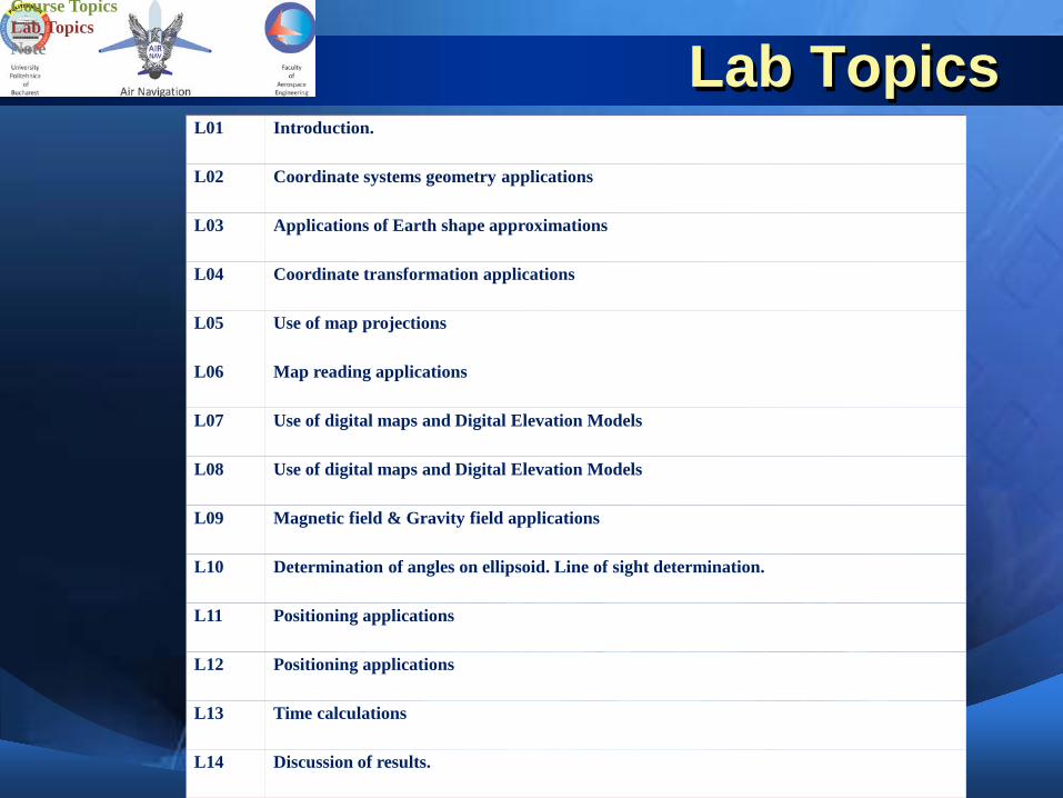
Lab TopicsL01 Introduction.
L02 Coordinate systems geometry applications
L03 Applications of Earth shape approximations
L04 Coordinate transformation applications
L05 Use of map projections
L06 Map reading applications
L07 Use of digital maps and Digital Elevation Models
L08 Use of digital maps and Digital Elevation Models
L09 Magnetic field & Gravity field applications
L10 Determination of angles on ellipsoid. Line of sight determination.
L11 Positioning applications
L12 Positioning applications
L13 Time calculations
L14 Discussion of results.
Course TopicsLab TopicsNote

QUESTIONS ?


![Curs TCD[1]](https://img.pdfslide.tips/doc/110x75/577c84731a28abe054b900c7/curs-tcd1.jpg)