Embed Size (px)
DESCRIPTION
Â
Citation preview
Mountain Rescue Service • BergrettungsdienstNon-Stop Tel.: +420 1210, +420 602 448 338
www.hscr.cz
Polski GOPRNon-Stop Tel.: +48 985, +48 601 100 300
Regionální turistické informační centrum KrkonošeKrkonošská 8, 543 01 Vrchlabí
Tel./Fax: +420 499 405 744, E-mail: [email protected]
1.
2.
3.
4.
5.
6.
7.
1.
2.
3.
4.
5.
6.
7.
8.
www.krkonose.eu
Seilbahnen mit Sommerbetrieb:
Pec pod Sněžkou - Hnědý vrch/BraunbergVelká Úpa - Portášky
Špindlerův Mlýn - Medvědín/SchüsselbergŠpindlerův Mlýn - Pláň/PlanurJanské Lázně - Černá hora/
Schwarzer BergHerlíkovice - Žalý/Heidelberg
Rokytnice nad Jizerou - Lovčenka Harrachov - Čertova hora/Teufelsberg
Krkonose CyclobusesFrom May to September, the highest Czech mountains use a network of cyclobuses to transport tourists and cyclists. For timetables, see www.krkonose.eu.
For detailed information on the operation of cyclobuses and for other tips for cycling trips, see www.krkonose.eu or the Krkonose mobile application.
Riesengebirgs-RadshuttlesVon Mai bis September durchkreuzen diese Radshuttles das höchste tschechische Gebirge und befördern Wanderer und Radwanderer samt Rädern (Fahrplan – siehe www.krkonose.eu).
Ausführliche Informationen über den Betrieb der Radshuttles und diverse Tipps zu Radausflügen bieten die Website www.krkonose.eu sowie die Mobile App des Riesengebirges.
Cable cars operated in summers:
Pec pod Sněžkou - Hnědý vrchVelká Úpa - Portášky
Špindlerův Mlýn - MedvědínŠpindlerův Mlýn - Pláň
Janské Lázně - Černá horaHerlíkovice - Žalý
Rokytnice nad Jizerou - Horní DomkyHarrachov - Čertova hora
The Krkonose Mountains offer 400 km of cycle tracks within the area of the National Park, and a further 300 km of tracks in the foothills.
Cycling in the Krkonose has its own specific rules. When in the Krkonossky National Park, cycling is allowed with certain restrictions, i.e., only on cycle tracks marked with engraved wooden markings or yellow KRNAP markings. Elsewhere, you will see road markings according to the Czech Tourist Club.
The mountain terrain is quite demanding and thus usually suitable only for mountain or trekking bikes. Please ride only on marked cycle tracks when in the Krkonossky National Park. The Krkonose Mountains
and their valuable nature deserve your attention, care and natural protection. Please do not leave the marked tracks for nature protection reasons. Do not leave litter. In some places you will be riding the route is also a hiking path. Warn hikers with your bell. Modify your speed to the road condition. Observe the visitor instructions of the Krkonossky National Park. Don’t forget the appropriate equipment – a helmet, gloves and a detailed cycle map. You will be riding on cycle tracks at your own risk.
Cycling in the Krkonose MountainsCyclists Are Welcome in the Krkonose!
Do Not Ride Your Bike Uphill!Take advantage of cable cars operated in summers where bikes are transported for free, use the Krkonose cyclobuses and enjoy the long descents into the valleys.
Hit the pedals, we wish you a safe journey and safe return.From Horni Mala Upa via Poland to Trutnov (43 km)
From Horni Mala Upa, ride across the old border crossing and join the Polish cycle track marked ER2. It will take you across the undulating Polish border regions via Opawa, Szcepanow and Bukovka to Lubawka. Take the Kralovec border crossing to get back to the Czech Republic.
A) Here you can take cycle track 4081, which runs
through Zacler (the Municipal Museum in Zacler) and along Stachelberg, the biggest fortification built before World War Two, above Babi. It continues near the new Eliska viewing tower and through the Skolni forest to Trutnov.
B) At the intersection in Kralovec, turn left for the quarry. Continue along the blue-marked cycle track (blue points) around the Kralovecky Spicak mountain and across Vrani hory ridge to the hexagonal chapel. Follow the asphalt road called Debrnska cesta, which runs near the former village Debrne and the Mrtve lake to Trutnov.
Rychory Descent (25 km)
From Horni Mala Upa, take the KRNAP 24 cycle track to Dolni Mala Upa, where you turn left near the church and head up to the Cestnik junction on the 1A cycle track, in a stretch known as the Capek Brethren’s Road. This track will take you past Lysecinska bouda mountain chalet
and via Horni Alberice to the Rychorsky kriz junction, from where you will continue to the Kutna junction and Rychorska chalet, where you can take refreshments and enjoy the magnificent views. Take cycle track 26 south through Rychory, pass along old gold mines and take a break at the Sejfy forest swimming pool. When refreshed, you can continue to Antoninovo Udoli, where you turn left for cycle track 26A to descend to Svoboda nad Upou.
From Spindlerova Chalet through Poland to Harrachov (33 km)
From Spindlerova chalet, carefully take the steep descent for Przesieka in Poland. After approx. 4.5 km you will reach a car park where you can join the ER2 cycle track and continue descending to Przesieka, where you can visit
the Podgornej waterfall. You can continue along the ER2 cycle track on the hillside along the Wrzosowski waterfall near Jagniatkow village to Szklarska Poreba. Ride carefully through the town towards the state border and turn left behind the bridge across the Kamienna brook. Slowly ascend along the railway line to Jakuszyce. After that, you can enjoy a long and comfortable descent on the main road to Harrachov.
Cycling Trip to Poland (32 km)Take a cyclo-bus to Spindlerova chalet, take the steep descent to Poland to the crossroads near the car park some 4.5 km away, and turn right onto international cycle track ER2. Continue down the Droga Sudecka road to Borowice, which you pass on the right. Ride past Borowickie Skalki and turn right. At the nearest crossroads, some 1.5 km away, turn right towards Karpacz Gorny (Wang church). Continue on the ER2
past the large Golebiewski hotel premises and cross the Lomnice brook. Pass Ksieza Gora on the right and continue on the ER2 past Western City towards Krzaczyn, a part of Kowary. Do not ride into the town centre but continue on the ER2 via Jedlinky and Glaz pamiatkowy. Take the Zolta Droga road above Gorne Kowary (Park Miniatur, radon spa, mine shafts 2 km long with some 100 m ascent). Continue climbing along the ER2 to the main roadway for Pomezni Boudy. Turn right and ascend to Pomezni Boudy – Horni Mala Upa, from which the bus departs at 4.50 p.m.
From Spindleruv Mlyn via Benecko to Vrchlabi (19 km)
Take a cable car from Spindleruv Mlyn to Medvedin. Follow the KRNAP 13A cycle track and descend to the mountain road. If you want to climb to the Hanc and Vrbata Monument in Zlate navrsi hill, turn right, otherwise continue to descend left to Horni Misecky (refreshments). Take cycle track 12 down to join cycle track 11 where you continue right to the Na Rovince
junction (refreshments). You can continue to Benecko on cycle track 10, or continue on cycle track 10A via Jansky hill to the Zaly viewing tower and enjoy the magnificent panoramic views of the mountains as well as the countryside. From Benecko, descend along the roadway to Krizovky junction and then to Vrchlabi.
Long Descent from Cerna hora Mountain (28 km)
Take a cable car from Janske Lazne to the top of Cerna hora. Continue along gravel roads on the KRNAP 19A cycle track, turn right around Cerna bouda chalet to cycle tracks 90, 19B, 38 and 1B past Kolinska bouda mountain chalet and Prazske boudy chalet. At the ‘Pod Lesni boudou’ junction turn left to Tetrevi boudy chalet. At the junction above the chalet, turn right onto the KRNAP 18 cycle track and continue on the Lisci hora hillside. The track winds past Zadni Rennerovky chalet
and you can see the sources of the Kotelsky brook on the left, enjoying beautiful views of the countryside. Near Lahrovy boudy chalet, turn left onto the asphalt road – cycle track 1A. Go down the track past Hribeci boudy chalet and continue to Strazny or further to Vrchlabi.
From the Monastery Garden – a Unique Place in Vrchlabi, to the Old Mineral Spa in Fort (34 km)
Your trip starts in the renewed monastery garden, featuring an exhibition on geology, pomology and botany, which is located past the Augustinian monastery in Vrchlabi. After a tour of the garden, ride to the train stop, where the ‘Labska’ cycle track 2 begins and runs to Hradec Kralove, or to Germany, to the estuary of the River Labe (the Elbe) in the North Sea. However, you will only take the track to Hostinne, where you can visit the Franciscan monastery and the Gallery of Antique
Art. For the return journey, take cycle track 4298 to Fort, a mineral spa until 1922, whose mineral spring still
emerges here and is available to passers-by. Ride under the Kuncice freight cable car – the longest
cable car in Central Europe, which transports quarried limestone
from Cerny Dul to Kuncice nad Labem, and continue to
Prostredni Lanov. Take the new cycle track which
runs along the main road
to go to Vrchlabi.
Enjoy the Long Distance Views on the Track from Harrachov to Hrabacov (35 – 41 km)
A) Take the main road from Harrachov to the border crossing in Jakuszyce. After approx. 2.5 km turn right onto the KRNAP 2 cycle track. You can enjoy splendid views of the countryside and the top parts of the western Krkonose all along the 13 km long journey to the Krakonosova snidane junction. From there, take cycle tracks 2B and 1A to the Rucicky junction.
Take cycle track 1A and ascend to Dvoracky chalet. Carefully take the short and steep descent to ‘Sedlo pod Dvorackami’ junction. Leave the 1A backbone cycle track and turn right onto cycle track 6 to the roadway which connects Rokytnice nad Jizerou and Rezek village. From the village, take cycle track 22
via Roudnice village to Hrabacov near Jilemnice.B) Take a cable car from Harrachov to Certova mountain. Take cycle track 4 around Janova rock and via Studenov to the Rucicky junction.
8.
Radtourismus im RiesengebirgeRadtourismus und Riesengebirge? Das passt!Das Riesengebirge hat 400 km Radwege auf dem Gebiet des Nationalparks und weitere 300 km im Vorland zu bieten.Allerdings hat der Radtourismus im Riesengebirge auch seine Besonderheiten. Das Radfahren auf dem Territorium des Nationalparks Riesengebirge unterliegt besonderen Einschränkungen und ist ausschließlich auf hierzu ausgesparten und ausgewiesenen Radwanderwegen (gravierte Kennzeichnung auf Holztafeln und gelbe KRNAP-Markierung) erlaubt. An allen sonstigen Orten begleitet Sie Rad-Straßenmarkierung laut Methodik des Klubs tsch. Touristen (KČT). Das gebirgige Gelände ist verhältnismäßig anstrengend zum Radwandern und daher Mountainbikes und Treckingrädern vorbehalten. Benutzen Sie auf dem
Territorium des Nationalparks bitte lediglich die ausgewiesenen Radwanderwege. Das Riesengebirge und seine wertvolle Natur verdienen sich unsere Aufmerksamkeit, unsere Rücksichtnahme und den Schutz seiner natürlichen Werte. Fahren Sie der Natur zuliebe bitte nicht abseits der markierten Radwege. Werfen Sie bitte keine Abfälle weg. Manche Abschnitte führen über normale Wanderwege. Warnen Sie die Wanderer bitte mit der Fahrradklingel. Passen Sie Ihre Fahrgeschwindigkeit der Wegbeschaffenheit an. Halten Sie die Bestimmungen der Besucherordnung des Nationalparks Riesengebirge ein. Nie ohne entsprechende Radausrüstung aufbrechen: Fahrradhelm, Handschuhe und eine ausführliche Radwanderkarte! Das Befahren der Radwanderwege erfolgt auf eigene Gefahr.
Warum bergan strampeln, wenn es nicht sein muss!
Also dann – rein in die Pedale, gute Fahrt und glückliche Heimkehr!
Aus Horní Malá Úpa über Polen nach Trutnov (43 km)Aus Horní Malá Úpa radeln wir über den früheren Grenzübergang und knüpfen auf polnischer Seite am markierten Fernradweg ER2 an. Dieser Radweg führt durch das hügelige polnische Grenzgebiet und über Opawa, Szcepanów, Bukovka zum Grenzort Lubawka. Über den Grenzübergang in Královec es geht dann zurück auf tschechisches Gebiet.A/ Hier fahren wir auf Radweg Nr. 4081 auf, der über Žacléř (Städtisches Museum Žacléř) und vorbei an der mächtigsten, vor dem 2. Weltkrieg erbauten Artilleriefestung Stachelberg und dem neu erbauten
Aussichtsturm Eliška über dem Ort Babí durch den Forst Školní polesí nach Trutnov.B/ An der Straßenkreuzung im Ort Královec biegen wir nach links zum Steinbruch ab. Auf dem blau markierten Radweg (blauer Punkt), vorbei am Königshaner Spitzberg/Královecký Špičák über den Travers des Rabengebirges/Vraní hory zu einer sechseckigen Schutzkapelle und weiter auf dem Asphaltweg „Debrnská cesta“ (aufgelassenes Dorf Debrné) und vorbei am Toten See/Mrtvé jezero nach Trutnov.
Rýchory-Abfahrt (25 km)
Aus Horní Malá Úpa geht es auf KRNAP-Radweg Nr.24 zum unteren Ortsteil Dolní Malá Úpa. Bei der Kirche biegen wir nach links auf Radweg Nr.1A ab und fahren nun zur Wegscheide Cestník hinauf. Dieser Radweg ist als ‚Weg der Gebrüder Čapek‘ bekannt. Vorbei an der Lysečinská bouda und über Horní Albeřice führt der Weg zum Rehornkreuz/Rýchorský kříž hinauf,
von da zur Wegkreuzung ‚Rozcestí Kutná‘ und weiter bis zur Rýchorská bouda. Hier gönnen wir uns eine Verschnaufpause, samt Imbiss und herrlicher Aussicht. Auf Radweg Nr. 26 geht es nun in südliche Richtung durch das Rehorngebirge/Rýchory, wobei wir an uralten Goldgruben – im Waldbad Sejfy machen wir wieder halt. Nach einem Snack radeln wir durch das hübsche Antonienthal/Antonínovo Údolí. Hier biegen wir nach links auf Radweg Nr. 26A ab und fahren nach Svoboda nad Úpou hinab.
Von der Spindlerbaude über Polen nach Harrachov (33 km)
Von der Spindlerbaude geht es in steiler Abfahrt – also langsam und vorsichtig – zum polnischen Przesieky hinab. Nach ca. 4,5 km gelangen wir an einen Parkplatz, wo wir auf Radweg ER2 auffahren und nach Przesieky abfahren, hier bietet sich ein Abstecher zum Hainfall/Wodospad Podgornej an. Weiter geht
es auf dem Radweg ER2 am Hang entlang, vorüber am Turmwasserfall/Wodospad Wrzosówski und der Siedlung Jagniatków, nach Szklarska Poręba. Hier radeln wir aufmerksam durch die Stadt bis zur Staatsgrenze und hinten der Brücke über das Flüsschen Zacken/Kamienna biegen wir links ab. Auf dem ER2 geht es nun entlang der Bahnstrecke allmählich nach Jakuszyce hinauf. Nun erwartet uns nur noch die bequeme Abfahrt auf der Straße 1.Klasse nach Harrachov.
Radausflug nach Polen (32 km)
Mit dem Radshuttle geht es zur Spindlerbaude hinauf, anschließend auf polnischer Seite ca. 4,5 km in steiler Abfahrt bis zur Kreuzung am Parkplatz hinab, wo wir nach rechts auf den internationalen Fernradweg ER2 abbiegen. Auf dem Radweg ‚Droga Sudecka‘ (Sudetenstraße) geht es bis zur Siedlung Borowice, die wir rechts umfahren. Wir kommen an Borowickie Skałki vorbei, hinter dem wir noch einmal rechts abbiegen. Nach ca. 1,5 km biegen wir an einer weiteren Kreuzung nach Karpacz Górny (Holzkirche Wang) ab. Auf dem ER2 geht es am riesigen Hotelkomplex Golebiewski
vorüber, kurz darauf überqueren wir die Lomnitz/Łomnica. Den Pfaffenberg/Księża Góra umfahren wir rechts und vorbei an der ‚Western City‘ fahren wir immer noch auf dem ER2 in Richtung Krzaczyna (Stadtteil von Kowary/Schmiedeberg) weiter. Wir weichen dem Stadtkern aus und radeln auf dem ER2 über Jedlinky und Głaz pamiątkowy (Denkmal) weiter. Der ‚Żółta droga‘ genannte Weg führt uns nach nach Kowary Górna (Miniaturenpark, Radonbad, 2 km langer unterirdischer Stollen mit circa 100m Überhöhung). Weiter geht es auf dem ER2 bergan, bis wir an der Bergstraße zu den Grenzbauden (Pomezní Boudy) angelangt sind. Hier biegen wir nach rechts ab und strampeln nach Pomezní boudy - Horní Malá Úpa hinauf (Busabfahrt - 16.50 Uhr).
Aus Špindlerův Mlýn über Benecko nach Vrchlabí (19 km)In Spindelmühle geht es erst einmal per Seilbahn
zum Schüsselberg/Medvědín hinauf und anschließend auf KRNAP-Radweg Nr. 13A zur Bergstraße hinab. Wer den ‚Knochen‘ zum Hanč-und-Vrbata-Ehrenmal auf der Goldhöhe/Zlaté návrší hinaufstrampeln möchte, muss nach rechts abbiegen, ansonsten geht es links nach Horní Mísečky hinunter (Imbissmöglichkeit). Auf Radweg Nr. 12 geht es zu Radweg Nr. 11 hinab, auf
dem wir nach rechts zur Wegkreuzung ‚Na Rovince‘ (Imbissmöglichkeit) gelangen. Hier können wir entweder auf Radweg Nr. 10 nach Benecko weiterfahren oder auf Radweg Nr. 10A über den Johannesberg/Janský vrch zum Heidelbergturm/Žalý hinaufstrampeln und hier den spektakulären Panoramablick auf die Berge und ins tiefe Landesinnere genießen. Aus Benecko geht es auf der Straße nach Křížovky hinab und weiter nach Vrchlabí.
Lange Abfahrt vom Schwar-zen Berg/Černá hora (26 km)
Mit der Kabinenseilbahn bequem aus Janské Lázně (Johannisbad) zum Schwarzen Berg hinauf. Nun geht es dem KRNAP-Radweg 19A folgend auf Schotterwegen entlang, unterhalb der Černá bouda biegen wir links auf Nr. 90, des Weiteren auf 19B, 38, 1B ab – vorbei an der Kolínská bouda und Pražská bouda. Unter der Waldbaude/Lesní bouda biegen wir zu den Auerwiesbauden/Tetřeví bouda
Klostergarten – einzigartiger Ort in Vrchlabí und das alte Mineralbad Fořt/Forst (34 km)
Die Radtour beginnen wir mit einem Besuch des neu angelegten Klostergartens mit geologischer, pomologischer und botanischer Ausstellung, der sich hinter dem Augustinerkloster in Vrchlabí befindet. Nach der Besichtigung geht es zum Bahnhof, bei dem der Fernradweg Nr. 2 beginnt, der über Hradec Králové auf deutsches Gebiet führt und der Elbe bis zu deren Mündung in die Nordsee folgt. Wir aber fahren nur bis Hostinné, wo wir das hiesige Franziskanerkloster und die Galerie antiker Kunst besichtigen. Zurück geht es auf Radweg Nr. 4298 nach Fořt/Forst, einem ehemaligen Mineralbad, das 1922 geschlossen wurde, dessen Heilquelle nichtsdestotrotz für alle Vorbeikommenden munter weitersprudelt. Wir unterqueren eine Materialseilbahn (die längste mitteleuropäische Seilbahn, die Kalkstein aus einem Kalkbruch in Černý Důl nach Kunčice nad Labem transportiert) und fahren nach Prostřední Lánov weiter. Nach Vrchlabí benutzen wir den neu angelegten Radweg entlang der Hauptstraße.
Von Harrachov nach Hrabačov – Tour der herrlichen Weitblicke (35 – 41 km)
A/Aus Harrachov auf der Hauptstraße in Richtung Grenzübergang Jakuszyce. Nach ca. 2,5 km biegen wir nach rechts auf Radweg Nr. 2 (KRNAP-Markierung) ab. Bis zur Wegkreuzung Rübezahl‘s Frühstückshall/Krakonošová snídaně begleiten uns herrliche Weitblicke ins Land und auf die Gipfelpartien des westlichen Riesengebirges. Auf Radweg 2B und anschließend 1A fahren geht es bis zur Wegscheide ‚Ručičky‘.Auf Radweg 1A geht es nun zur Hofbaude/Dvoračky hinauf. In kurzer, aber steiler Abfahrt (Vorsicht geboten) geht es von hier zum Sattel unter der Hofbaude/Sedlo pod Dvoračkami hinab. Hier verlassen wir die Hauptradroute 1A und fahren nach rechts auf Radweg Nr. 6 bis zur Verbindungsstraße zwischen Rokytnice nad Jizerou und der Siedlung Rezek hinab, auf der wir nun tatsächlich nach Rezek fahren. Weiter geht es auf Radweg Nr. 22 über die Siedlung Roudnice nach Hrabačov bei Jilemnice.B/Mit dem Sessellift zum Teufelsberg/Čertová hora. Auf Radweg Nr. 4, vorbei am Johannisstein/Janova skála, über Studenov in Richtung Ručičky.
ab. An der Wegscheide über Tetřeví boudy biegen wir nach rechts auf Radweg Nr. 18 ab und radeln am Hange des Fuchsberges/Liščí hora entlang. Der Weg schlängelt sich unter den Hinteren Rennerbauden/Zadní Renerovky entlang. Links bietet sich das üppige Quellgebiet des Kesselbaches/Kotelský potok dem Blick dar, vom herrlichen Weitblick ins Land ganz zu schweigen. Unter den Lahrbauden biegen wir links ab und fahren auf einen Asphaltweg, den Radweg 1A auf. Auf diesem geht es an den Füllebauden/Hříběcí boudy vorbei nach Strážné und weiter nach Vrchlabí.
Gönnen Sie sich den Komfort der Seilbahnen mit Sommerbetrieb (die Fahrräder werden gratis befördert) oder Radshuttles – dann geht es nur noch unendlich lange zu Tal!
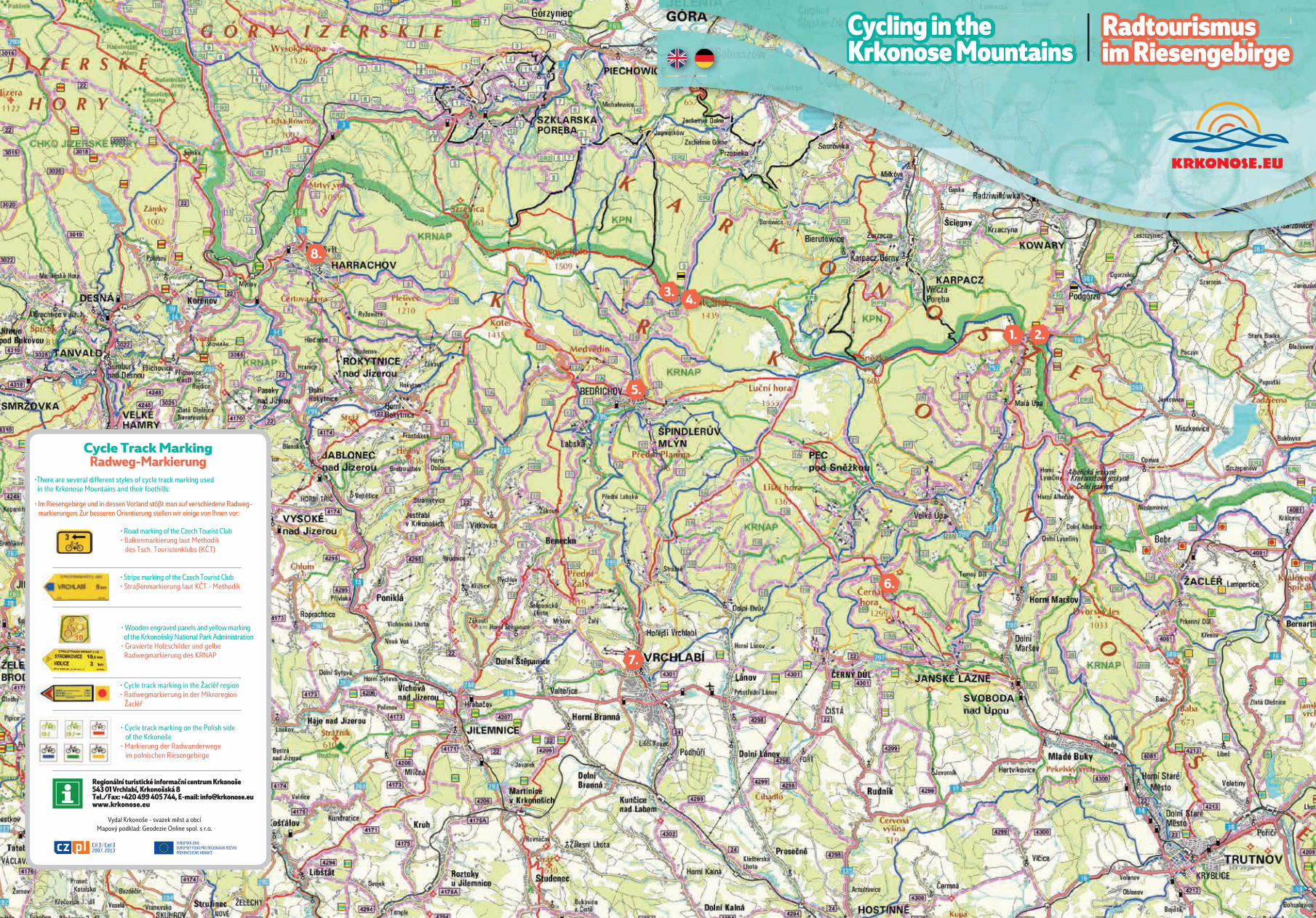
• Cycle track marking on the Polish side of the Krkonoše• Markierung der Radwanderwege im polnischen Riesengebirge
• Cycle track marking in the Žacléř region• Radwegmarkierung in der Mikroregion Žacléř
• Wooden engraved panels and yellow marking of the Krkonošský National Park Administration• Gravierte Holzschilder und gelbe Radwegmarkierung des KRNAP
• Road marking of the Czech Tourist Club• Balkenmarkierung laut Methodik des Tsch. Touristenklubs (KČT)
Cycle Track MarkingRadweg-Markierung
• Stripe marking of the Czech Tourist Club• Straßenmarkierung laut KČT - Methodik
•There are several different styles of cycle track marking used in the Krkonose Mountains and their foothills:
• Im Riesengebirge und in dessen Vorland stößt man auf verschiedene Radweg- markierungen: Zur besseren Orientierung stellen wir einige von Ihnen vor:
Regionální turistické informační centrum Krkonoše543 01 Vrchlabí, Krkonošská 8Tel./Fax: +420 499 405 744, E-mail: [email protected]
Vydal Krkonoše - svazek měst a obcíMapový podklad: Geodezie Online spol. s r.o.
1. 2.
3. 4.
5.
6.
7.
8.
Cycling in the Krkonose Mountains
Radtourismus im Riesengebirge