Embed Size (px)
Citation preview

[Type here]
Grovesend to Pontarddulais Engineering Feasibility Report
December 2018

[Type here]

[Type here]
About Sustrans
Sustrans is the charity making it easier for people to walk and cycle.
We connect people and places, create liveable neighbourhoods, transform the school run and
deliver a happier, healthier commute. Join us on our journey. www.sustrans.org.uk
Sustrans yw’r elusen sy’n ei gwneud yn haws i bobl gerdded a beicio.
Rydym yn cysylltu pobl a llefydd, yn creu cymunedau byw, yn trawsnewid y daith i’r ysgol ac yn
hwyluso taith hapusach ac iachach i’r gwaith. Ymunwch â ni ar ein siwrne. www.sustrans.org.uk
National Office: Sustrans
123 Bute Street
Cardiff
CF10 5AE
Head Office: Sustrans
2 Cathedral Square
College Green
Bristol
BS1 5DD
© Sustrans 17
Registered Charity No. 326550 (England and Wales) SC039263 (Scotland)
VAT Registration No. 416740656

[Type here]
1. Project Overview
Sustrans has been awarded RDP funding from the Welsh Government in order to deliver the “Development of
the walking and cycling network in rural Wales project”. The project intends to support local authorities and
local communities in filling in gaps in the National Cycle Network (NCN), to improve links between rural
communities, local services and tourism destinations. The Pontarddulais to Grovesend project is one of eight
identified gaps.
The Pontarddulais scheme has been identified and prioritised through feasibility and gaps analysis. The local
authorities, tourism providers and community groups have been brought together to form a Stakeholder
Group. Supported by BRO Partnership, Sustrans is working closely with this group to work through a detailed
delivery plan taking the scheme forward to construction.
2. Scheme overview
As part of the delivery plan Sustrans has carried out an engineering feasibility study to develop a new multi-
user route connecting Pontarddulais to Grovesend, using a traffic free route along a former railway alignment.
Two options are then considered, the first continues along a former railway spur to link into the road network at
a bridge over the live railway then utilising a proposed shared use alignment alongside a busy road. The
second option links the former railway alignment to Pontarddulais via Allt-Y-Graban Road and a path through the former Colliery site. The study will also look at links through the built up area of Pontarddulais.
The project also links to the overall work that the City and County of Swansea is doing to develop a link from
Gowerton and NCN 4 to Pontarddulais.
Stakeholder engagement identified a need for the following inputs:
- Provision of a surface suitable for all users (walking, cycling, horse riding)
- Path widening
- Reduced gradients
- Drainage solutions.

[Type here]
Map 1 Proposed Grovesend to Pontarddulais alignment (Black dots indicate Option 2)

[Type here]
The alignment has been divided into sections divided according to status, path surface and specific
engineering challenges.
Former Railway Line Cutting Option 1
Pentre Farm Pentre Road Railway Bridge Pentre Road Shared Use Path
Option 2 Allt-Y-Graban Road Former Colliery Site Short section of Pentre Road Shared Use Path Coed Bach Park Pontarddulais Town
Indicative costs
All indicative costs are from a Sustrans database of unit costs derived from schemes Sustrans has built.
Design costs (15%), a contingency (20%) and a contractor’s management (10%) have been added. Traffic
Management, Land purchase costs and VAT are not included.
In carrying out this study the following core principles for ensuring cycle routes are of a high quality have been
followed:
Coherence
Directness
Safety
Comfort
Attractiveness
Adaptability
In line with current Highways England guidance, Interim Advice Note 195, the designs should take into
consideration the variety of bicycle styles available. The longer term objectives of the route are to provide a
high quality walking and cycling corridor between Pontarddulais and Grovesend.
Designers should therefore recognise that the style of bicycles may change during the course of the week. The
diagram overleaf is taken from HE 195 and provides basic design sizes for a number of bicycle styles. Any
control barriers installed along the route should reflect the dimensions indicate, however this report suggests
that barrier controls are not installed from the outset, and that other options should be considered before
installing them.

[Type here]
Figure 2.1 Highways England IAN 195 Bicycle dimensions

[Type here]
3. Alignment
3.1 Former Railway Line Cutting (750metres)
The railway cutting from Station Road, where the existing multi user path ends stretches north for 750m to
a bridge over Allt-Y-Graban Road. The former track bed in the base of the cutting is heavily overgrown
and standing water forms for most of the year. Parallel with and to the west of the cutting a rough track
marked as a bridleway (on British Horse Society maps) is clearly used by pedestrians and possibly
cyclists. This land is designated common land and therefore any formal route through it would be classed
as a reduction in common grazing land.
Therefore from Station Road there are two options for continuing the route. A path in the cutting following
the former track bed or a path following the existing rough track parallel to the railway cutting.
Map 3.1 - Former Railway Line Cutting
Use of this rough track as a base for the multi user path would have advantages. The raised nature of the
existing track in comparison to the track bed means that it is dryer and would therefore require less
drainage provision, a reduced thickness of sub base and no need for timber edging. Savings would also
be made in vegetation clearance. Ecological disruption would also be reduced as the cutting is home to
ecologically sensitive plant and animal species (See separate ecology study for further details). However,
the importance of common land status and the difficulties in building a path across it are a considerable
hurdle to overcome.

[Type here]
On the approach to Allt-Y-Graban Road the rough track heads west to link into the road. The multi user
path alignment dips down onto the track bed to pass under the road bridge and continue north towards
Pentre Farm.
Photo’s 3.1 and 3.2 – Former railway line.
Cost Estimate
Location Description Estimate
A. Former railway
alignment
(Bridleway)
Vegetation clearance and new path
construction
£160,900
B. Former railway
alignment (path in
cutting)
Vegetation clearance and new path
construction (including an extra
thickness of sub base and timber
edging).
£255,000
Station Road and Allt-Y-
Graban Road
Access points £2,900
Station Road and Allt-Y-
Graban Road
Direction signing £2,200
Total (A) £166,000
Total (B) £260,000

[Type here]
Drawing 3.1 – Former Railway Line Cutting
219

[Type here]
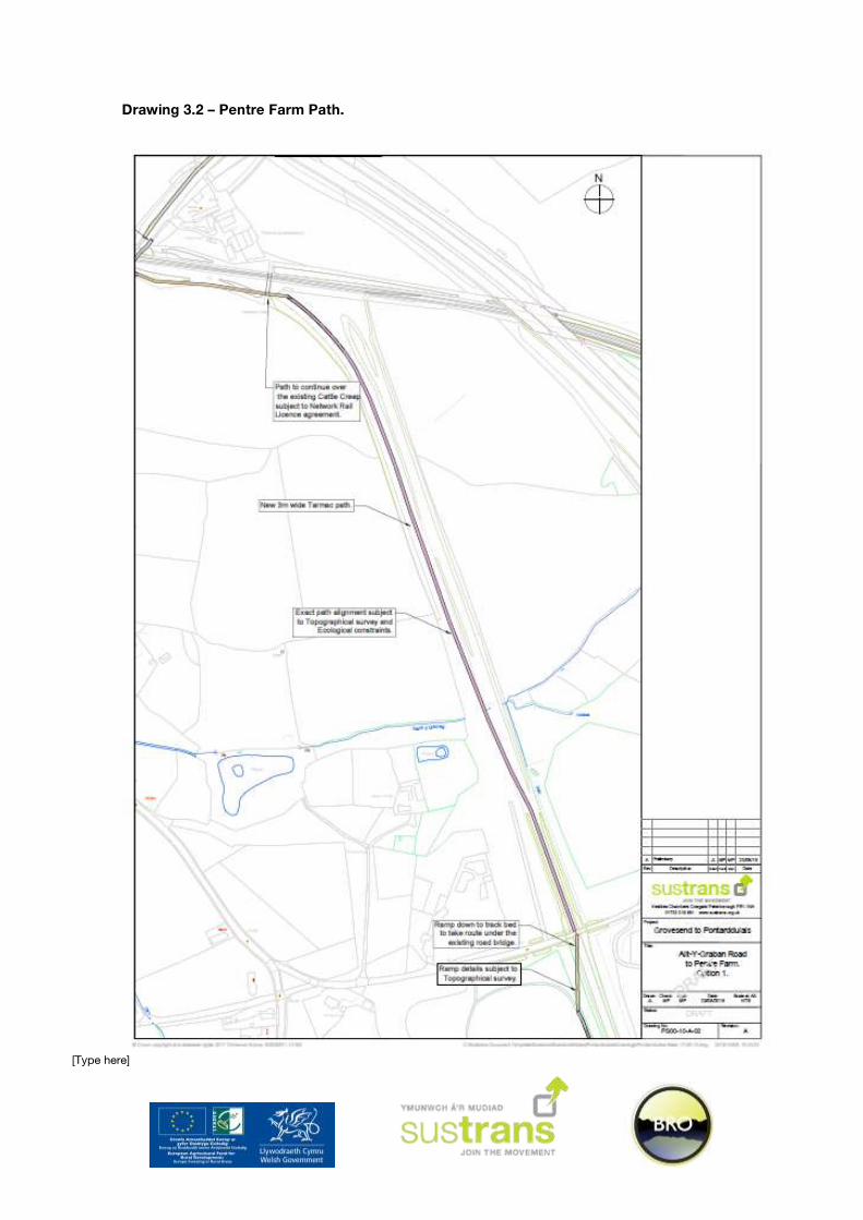
3.2 Option One - Pentre Farm (950 metres)
From Allt-Y Graban Road the former railway alignment continues north to Pentre Farm rising to a
heavily overgrown embankment. For this route section there is no possible parallel route with farm land
bordering the railway. At Pentre Farm the railway alignment would previously have linked into the
existing operational railway. The farm is provided with a cattle Creep under the live railway and a route
would need to pass on top of this structure at the same time being far enough away from the live
railway to satisfy Network Rail safety considerations.
Between the Cattle Creep and Pentre Road the land rises then falls away to leave a steep bank up to
the road. A narrow rough track used by Network Rail staff provides access between the road and
railway.
Map 3.2 - Pentre Farm
Subject to checks on the ecology present along this section of the former railway construction of a
multi user path on the former track bed embankment should be more straight forward than the
previous section due to better existing drainage. However, the costs included below use the same
additional sub base costs and include timber fencing to ensure a robust estimate. On-going
discussions with Network Rail indicate that it will be possible to agree a licence allowing a path to be
constructed within their land, subject to the offset from the live rail being acceptable. The offset is
critical in two points, the Cattle Creep and where the railway land narrows for a short distance.

[Type here]
Access onto railway land was not possible during the site visit and therefore the distance between the
live rail and the end of the Cattle Creep could not be measured. Should this distance not be sufficient
to accommodate both the required offset and a multi user path (A minimum of 10 metres), then a new
structure would be needed in front of the Cattle Creep potentially adding considerable cost to the
project.
In order to address the level change from Pentre Road a corner of Pentre Farm land would be required
to allow the construction of an access ramp. It is understood that the Council are considering the
purchase of this land along with a further small section before the present owner retires in 18 months’
time (The present owner has indicated support for the scheme and is prepared to sell the land).
Photo 3.1, 3.2, 3.3 and 3.4 – Path down from Pentre Road, Cattle Creep and views across the field from Pentre Road.
[Type here]
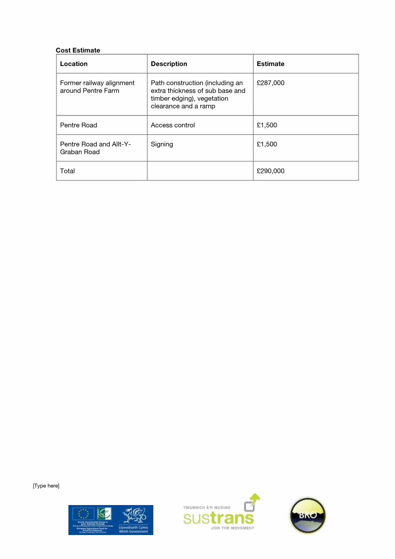
Cost Estimate
Location Description Estimate
Former railway alignment
around Pentre Farm
Path construction (including an
extra thickness of sub base and
timber edging), vegetation
clearance and a ramp
£287,000
Pentre Road Access control £1,500
Pentre Road and Allt-Y-
Graban Road
Signing £1,500
Total £290,000
[Type here]
Drawing 3.2 – Pentre Farm Path.

[Type here]
3.3 Option One - Railway Bridge (60 metres)
The existing bridge is approximately six metres wide without footways although footways are present
on the west side of Pentre Road as far as the bridge parapets. Safety barriers are present on all four
approaches to the bridge. There are three option to link the route from Pentre Farm to a shared use
path alongside Pentre Road on the west side of the bridge:
1. The existing bridge is due to be replaced by Network Rail. A new bridge could be designed with a
wider deck allowing the inclusion of facilities for pedestrians and cyclists. This is the best solution
for the project although the timescales are not ideal, five years would be an optimistic estimate for
the opening of a new bridge. This does not fit into the timescale for when the present owner of
Pentre Farm will be moving on and therefore the required land would need to be purchased in
advance of the new bridge being completed.
2. Build a new pedestrian and cycle bridge alongside the existing railway bridge. Technically this
would be possible but would be expensive. Negotiating the required agreements with Network Rail
would also be time consuming.
3. Introduce traffic signals and one way working on the bridge allowing a shared use path to be
constructed in one of the former traffic lanes. Technically this should be achievable although the
signals would need to be set back to avoid the existing safety barriers. However, Swansea City
Council Officers expressed concern regarding this option during a site visit based on the delay that
would be caused to traffic for low cycle flows.
The replacement bridge paid for by Network Rail is the cheapest option in terms of the project, if not
ideal in terms of timescales. In the short term the traffic signals option on the existing bridge would be
considerably cheaper than new pedestrian cycle bridge should it be possible to change the Councils
opinion.
Map 3.3 - Railway Bridge

[Type here]
Photo’s 3.5 and 3.6 – Railway Bridge Public Highway
Cost Estimate
Location Description Estimate
Pentre Road Railway Bridge New Network Rail Bridge No cost to the project?
Pentre Road Railway Bridge New pedestrian and cycle bridge £2,000,000
Pentre Road Railway Bridge Signals and carriageway narrowing over
the existing bridge.
£60,000
Drawing 3.3 – Pentre Road Bridge.

[Type here]
3.3 Option One - Pentre Road Shared Use Space (690 metres)
There is an existing narrow footway (approx. 1.2m) in the verge on the north western side of Pentre
Road. At the bridge end this footway is in front of a safety barrier to protect vehicles from a steep bank.
Between the railway and motorway bridge the path is for the most part set back from the edge of
carriageway. Again, on the approach to the motorway bridge a safety barrier runs behind the footway
limiting the available width to widen. The footways across the Motorway itself are a little over 2 metres
in width with parapets below the required 1.4 metres. The south eastern verge has no footway but is
wider in places than the northern verge.
There is a medium pressure gas main that crosses Pentre Road between the Railway and Motorway
bridges. A high pressure gas main crosses the road further north within the built up area. Therefore,
any works taking place within three metres of mains will need to be carried out with the permission and
supervision of Wales and Western Utilities.
Map 3.4 - Pentre Road Shared Use Space

[Type here]
Provision of a shared use path on the western verge could be achieved by widening the existing
footway. However, a new path on the eastern side of Pentre Road would tie in with the appropriate
side of the motorway bridge to widen the footway at the expense of the carriageway at this point.
Further down Pentre Road this verge widens out and links into existing old road sections past the
cemetery. A crossing of Pentre Road would be required to link the route into Coed Bach Park.
Photo’s 3.7 and 3.8 – Pentre Road northbound views
Photo’s 3.9 and 3.10 – Motorway bridge footway and high pressure gas main
Cost Estimate
Location Description Estimate
Motorway Bridge Widen footway into the
carriageway. Add parapet
extension.
£62,400
Pentre Road Widen footway / new path
construction
£34,800
Pentre Road Access control and signing
(direction and regulatory).
£4,000
Total £101,200

[Type here]
Drawing 3.4 – Pentre Road Shared Use.

[Type here]
3.4 Option Two – Allt-Y-Graban Road (670 metres)
To link the path from the former railway alignment to the former Colliery site a connection along Allt-Y-
Graban Road would be necessary. This road is subject to the national speed limit with narrow pinch
points at the railway bridge and where the road goes under a motorway bridge. Allt-Y-Graban Road
gives access between the A48 and B4296 Pentre Road. There are very few properties accessed from
the road but significantly there is a Garden centre signed from both major roads.
Map 3.5 - Allt-Y-Graban Road
Given relatively low traffic flows it is considered that the existing carriageway, with some changes
would be suitable as a route section. A reduction in the speed limit with appropriate gateways and
traffic calming features should be installed.

[Type here]
Photo’s 3.11 and 3.12 – Allt-Y-Graban Road - National speed limit and Motorway Bridge
Cost Estimate
Location Description Estimate
Allt-Y-Graban Road Gateway features and traffic
calming
£26,100
Allt-Y-Graban Road Cycle activated warning signs £21,750
Allt-Y-Graban Road Signing £2,900
Total £50,750

[Type here]
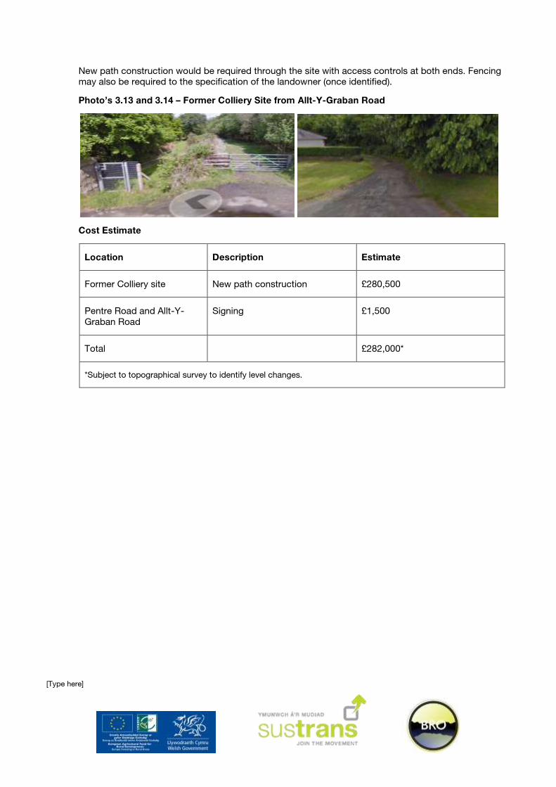
3.5 Option Two – Former Colliery Site (1350 metres)
An existing rough track runs through the former colliery site between Pentre Road and Allt-Y-Graban
Road. There appear to be no structures to negotiate along this track although there are significant level
changes across the site identified during the Ecological study. The measures required to overcome the
changes in level have not been identified due to problems with gaining access to the site. Early
attempts to contact the landowner have not met with a positive response and therefore, whilst
remaining an option, a route through the former colliery site has not been examined in any further
detail.
Historic mapping indicates that the existing track used to be a railway spur onto the main line (see
below).
Historic mapping - Ordnance Survey 1:25,000 1937 – 61.
Map 3.6 - Former Colliery Site
[Type here]
New path construction would be required through the site with access controls at both ends. Fencing
may also be required to the specification of the landowner (once identified).
Photo’s 3.13 and 3.14 – Former Colliery Site from Allt-Y-Graban Road
Cost Estimate
Location Description Estimate
Former Colliery site New path construction £280,500
Pentre Road and Allt-Y-
Graban Road
Signing £1,500
Total £282,000*
*Subject to topographical survey to identify level changes.

[Type here]
3.3 Option Two - Pentre Road Shared Use Space (100 metres)
The short section of Pentre Road between the Show Ground entrance and the track leading to the
former Colliery site has wide verges with an existing narrow footway on the west side. Little parking
occurs on this stretch of the road and the large properties fronting onto the east side have off street
parking. A high pressure gas main crosses Pentre Road within this section (See Appendix A). The road
is subject to a 30mph speed limit with good visibility possible for a crossing point.
Map 3.7 - Pentre Road Shared Use Space
The eastern verge has sufficient width to provide a three metre wide shared use path the only
complication being the restrictions imposed by the need to pass over the HP gas main. Consultation
with Wales and Western Utilities will provide information on the required working practises. These are
likely to involve no dig and low vibration build in the area three metres either side of the main. A cycle
pedestrian Zebra or Toucan crossing would provide a safe crossing facility located between private
access points. This takes the route onto the west side of the road where a widened existing tarmac
bath links into the show ground entrance.

[Type here]
Photo’s 3.15 and 3.16 – Pentre Road and the existing footway.
Cost Estimate
Location Description Estimate
Motorway Bridge Widen footway into the
carriageway. Add parapet
extension.
£9,000
Pentre Road New crossing point £21,800
Pentre Road Access control and signing
(direction and regulatory).
£3,600
Total £34,400

[Type here]
3.4 Coed Bach Park (680 metres)
A gate provides access from Coed Bach to the park. Narrow Tarmac pedestrian paths are provided
through the park around the edge of playing fields with a Bark path provided through the area of
Ancient Woodland. Within the wood there is a timber bridge over a stream. The Ancient Woodland
severely restricts the surface type and construction methods that can be used in the area. It also puts
into doubt the option of providing any type of lighting through the woodland. As a minimum surveys
over a year timeframe would be required to identify the possible presence of light sensitive species
such as bats. After this time it would still not be possible to guarantee that even low level lighting would
be allowed.
Map 3.8 - Coed Bach Park
The existing Tarmac paths should be widened to three metres (400m in total) where required as they
negotiate the playing fields, with a wider access control to replace the existing gate. Through the
woodland the protected nature of the site makes Tarmac an inappropriate surface choice. An
alternative would be to provide wooden edging for the existing surface (200m) which could then be
levelled. This would reduce the current spread of Bark into the surrounding woodland and could be
carried out using the minimum of machinery. A small replacement bridge with parapets would be
required, to fit in with the setting this could be constructed from Green Oak.

[Type here]
Low level lighting for the park paths and at the Pentre Road end of the route section has been included
in the below estimate. Lighting has not been included through the Ancient Woodland.
Photo’s 3.17 and 3.18 – Tarmac paths through Coed Bach Park.
Photo’s 3.19 and 3.20 – Bark path through the wood and timber bridge.
Cost Estimate
Location Description Estimate
Existing narrow tarmac
paths
Widen existing tarmac paths £24,900
Existing Bridge New Green Oak bridge £26,100
Existing access controls Remove existing and install
bollards. Direction signing
£4,300
Bark paths through wood Edge and level existing £55,700
All paths (except through
Ancient Woodland)
Install low level lighting £23,200
Total £134,200

[Type here]
Drawing 3.5 – Path through Coed Bach Park

[Type here]
3.6 Pontarddulais Town (1.25 km)
Notes taken during the scheme site visit have been included below. Any works to take place within the
town are to be subject to further consultation. Due to the preliminary nature of this aspect of the route
no cost estimates have been determined.
A48 St Teilo Street. Judged to be unsuitable for contra flow cycling. There is parking on both sides of
the road with a narrow single traffic lane to take all vehicles including HGV’s. To make contra flow work
one lane of parking would need to be removed. This would be unacceptable to the local community
and to Swansea City Council.
St Teilo Street / Tidal Reach junction. Analysis shows that the key pedestrian desire line is across
Station Road. There are no crossing facilities on this arm of the signal controlled junction. Swansea
City Council will look at introducing a raised table across the arm and providing a crossing facility.
Dulais Road. Also considered for contra flow. This could probably be done by shifting the carriageway
and parking bays across into the footway on the western side. This would be expensive and likely to
meet with opposition from residents.
Alternatives
Quiet roads approach. Linking the Park to the Station. The route would begin on Coed Bach where
the existing access control into the park would be changed. Coed Bach only gives access to the park
for cycles and pedestrians along with residents of the road, it is therefore quiet and suitable with little
change to be part of the route.
Trinity Place / St Teilo Street junction / Glyn-iiwchwr Road. Push the 20mph zone out to include the
Trinity Place junction. Introduce raised tables across the junction (or entire area. Provide a crossing
point of St Teilo Street.
Glyn IIwchhwr Road is one way at the bottom end from Oakfield Street. ‘Except Cycles’ would need
to be put in place. As a residential access road the remainder of this road should be O.K for use as part
of the route.
Dulais Road (Glyn IIwchwr Road junction to Tyn Y Bonau Road junction. Standard width footways.
Road provides access to a large housing estate, a school and a small amount of industry. Road is too
busy as it is to be part of the route. A possibility would be to remove the centre lines and widen a
footway to provide shared use.
Dulais Road / Water Street junction. Southbound one way system, two very sharp bends. Introduce
raised area with a pedestrian and cycle crossing point.
Water Street. A dead end road but with access to a pedestrian bridge over the river to Water Street
(again). The dead end is fine as part of a route, the bridge has the width but would need higher
parapets.
Water Street (One way system section). There is sufficient width in the southern footways once the
vegetation is removed to provide a shared use facility through the small carpark and as far as the zebra
crossing next to St Michael’s Avenue. A raised table could be installed across St Michaels Avenue and
the Zebra crossing could be converted to a cycle Pedestrian Zebra. Benches and a bin would also
need to be moved from Water Street. A route would continue on the north side of Water Street either
on widened footway or through the small car park. Once at the end of the car park access is provided
to a new housing estate and there is the potential to link through a development site to Station Road. A
new crossing point and short section of verge path would link the route into the Station.
Tidal Reach. There is an existing shared use path 3m wide from the Water Street junction past the
Tesco access into the new housing estate. There is a link around the Tesco building to the car park
which in turn links back to St Teilo Street. The Tidal Reach path could provide another link into the
park and potentially part of a circular route around the town.

[Type here]
Photo’s 3.21 and 3.22 – A48 St Teilo Street and Dulais Road.
Photo’s 3.23 and 3.24 – Water Street junction and
Photo’s 3.25 and 3.26 – Water Street bridge and Glyn IIwchwr Road
Photo’s 3.27 and 3.28 – Coed Bach and park access.

[Type here]
4. Conclusions and Recommendations
The findings of the report are as follows:
That construction of an improved walking and cycling corridor between Grovesend and Pontarddulais is a
viable proposition, however it will need to address various concerns in order to ensure that a high quality
provision is delivered.
An ecological assessment has been carried out and has influenced the route design in key areas.
Network signing should consider links to key destinations. As this corridor is intended to form a part of a
wider link a variety of destinations should also be considered.
An overview of likely costs is included below for reference. Costs may vary, and will require detailed design
drawings to enable a further breakdown.
5. Estimates Summary Table
Route Section Description Estimated Cost
Former Railway alignment
(Bridleway route) Vegetation clearance, new path construction (Tarmac). £166,000
Former Railway alignment
(in the railway cutting)
Vegetation clearance, new path construction (Tarmac). £260,000
Option One Pentre Farm former railway alignment £290,000
Railway Bridge (Signals installation) £62,400
Pentre Road £38,800
Option Two Allt-Y-Graban Road - traffic calming and signing. £50,750
Former Colliery Site - Vegetation clearance, new path construction
and access points (subject to topo survey and land agreement).
£282,000
Pentre Road – Widen existing short length of existing footway and
provide a new crossing point.
£34,400
Coed Bach Park Widening of existing Tarmac paths, edging and levelling of path
through ancient woodland.
£134,200
Overall Total Option One (based on a path following the bridleway and signal control at the Pentre Road Bridge).
£691,400
Option One (based on a path in the railway cutting and signal control at the Pentre Road Bridge).
£785,400
Option Two (based on a path following the bridleway). £667,350
Option Two (based on a path following the railway cutting). £761,350

[Type here]
Appendix A