Embed Size (px)
Citation preview

7/23/2019 HFY3-3125-CIV-SPC-0001_0 Code A
http://slidepdf.com/reader/full/hfy3-3125-civ-spc-00010-code-a 1/7
ARIFFIN MUSA 09-04-15

7/23/2019 HFY3-3125-CIV-SPC-0001_0 Code A
http://slidepdf.com/reader/full/hfy3-3125-civ-spc-00010-code-a 2/7
Petrochina(Halfaya)
HALFAYA PROJECT
SURFACE FACILITY
PHASE THREE
DETAIL DESIGN Doc.No: HFY3-3125-CIV-SPC-0001 Rev. 0 Page 2 OF 6
CONTENT
1.
INTRODUCTION ......................................................................................................... 3
2. DEFINITIONS .............................................................................................................. 3
3. SCOPE OF WORK ..................................................................................................... 4
4. COORDINATE SYSTEM AND ELEVATION SYSTEM .............................................. 4
5.
CONTROL SURVEY ................................................................................................... 4
5.1
Layout of Control Points .......................................................................................... 4
5.2 Coding of Control Points .......................................................................................... 4
5.3
Construction of Control Points ................................................................................ 5
5.4
Surveying of Control Points ..................................................................................... 5
6.
SURVEY REQUIREMENT .......................................................................................... 5
6.1 CPF3 ........................................................................................................................... 5
7. UNDERGROUND FACILITIES DETECTION ............................................................. 5
8.
DELIVERABLES ......................................................................................................... 6
8.1
Deliverables List ........................................................................................................ 6
8.2 Requirement of Topographical Survey Report ....................................................... 6
Att h t
7/23/2019 HFY3-3125-CIV-SPC-0001_0 Code A
http://slidepdf.com/reader/full/hfy3-3125-civ-spc-00010-code-a 3/7
Petrochina(Halfaya)
HALFAYA PROJECT
SURFACE FACILITYPHASE THREE
DETAIL DESIGN Doc.No: HFY3-3125-CIV-SPC-0001 Rev. 0 Page 3 OF 6
1. INTRODUCTION
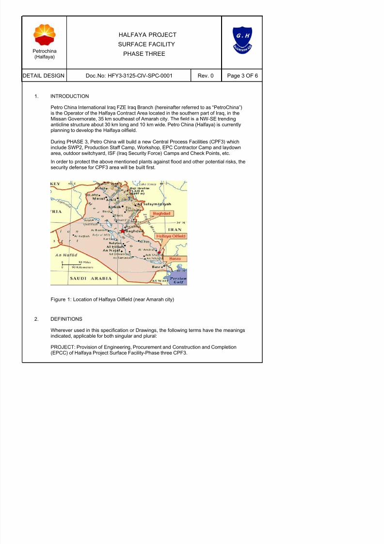
Petro China International Iraq FZE Iraq Branch (hereinafter referred to as “PetroChina”)is the Operator of the Halfaya Contract Area located in the southern part of Iraq, in theMissan Governorate, 35 km southeast of Amarah city. The field is a NW-SE trendinganticline structure about 30 km long and 10 km wide. Petro China (Halfaya) is currentlyplanning to develop the Halfaya oilfield.
During PHASE 3, Petro China will build a new Central Process Facilities (CPF3) whichinclude SWP2, Production Staff Camp, Workshop, EPC Contractor Camp and laydownarea, outdoor switchyard, ISF (Iraq Security Force) Camps and Check Points, etc.
In order to protect the above mentioned plants against flood and other potential risks, thesecurity defense for CPF3 area will be built first.

7/23/2019 HFY3-3125-CIV-SPC-0001_0 Code A
http://slidepdf.com/reader/full/hfy3-3125-civ-spc-00010-code-a 4/7
Petrochina(Halfaya)
HALFAYA PROJECT
SURFACE FACILITYPHASE THREE
DETAIL DESIGN Doc.No: HFY3-3125-CIV-SPC-0001 Rev. 0 Page 4 OF 6
EPC CONTRACTOR: EPC CONTRACTOR has the meaning assigned to it in the FORM
OF AGREEMENT whose PROPOSAL has been accepted and shall, where the contextso admits, include SUBCONTRACTORS, employees, agents, workmen and/orrepresentatives, successors and permitted assigns.
3. SCOPE OF WORK
The Topographical Survey Scope of Work shall contain, but not limited to:
Topographical survey;
Detection and survey for existing underground pipelines, if any;
Boundary pegging work;
Prepare and submit topographical report including topographical map;
4. COORDINATE SYSTEM AND ELEVATION SYSTEM
Please refer Attachment-1 for the coordinate reference system (CRS) for all works inCPF3.The elevation system shall be given by COMPANY before field operations.
5. CONTROL SURVEY
5.1 Layout of Control Points
Location and arrangement of Control Survey Points shall meet the need of detailed
design and construction. Generally, the location and arrangement of Control SurveyPoints shall abide by the following items.
Control and cover the scope of topographical survey
To be located nearby the proposed facilities
Be convenient to use for surveyors and construction

7/23/2019 HFY3-3125-CIV-SPC-0001_0 Code A
http://slidepdf.com/reader/full/hfy3-3125-civ-spc-00010-code-a 5/7
Petrochina(Halfaya)
HALFAYA PROJECT
SURFACE FACILITY
PHASE THREE
DETAIL DESIGN Doc.No: HFY3-3125-CIV-SPC-0001 Rev. 0 Page 5 OF 6
5.3 Construct ion of Control Points
The control points should be located at a stable position with open sky, which iscomparatively higher than the surroundings. A sketch drawing with digital picture shouldbe prepared for each control point.
5.4 Surveying of Control Points
Before topographical survey works at worksite, at least three (3) existing control points
with known coordinate and elevation shall be provided by COMPANY, and these controlpoints shall be arranged uniformly around the worksite and keep good conditions.
The method of Static GPS Positioning should be used for surveying of control pointsbased on existing control points before topographical survey.
The survey marks should be painted red for easy identification.
6. SURVEY REQUIREMENT
The topographical survey shall include detailed information with respect to the groundprofile coordinated grid lines, topography, surface conditions and characteristics, existingvegetation, underground pipelines, location of power cables, overhead lines and all otherrelevant features that will impact PROJECT.
6.1 CPF3
6.1.1 Survey Scope
Generally, the survey scope shall start from 10m outside of external ditch to 10minside centreline of the patrol road at the straight section and the survey width shallbe increased at the turning section of the road.
Refer attachment-1 for plan and layout coordinates of survey scope.

7/23/2019 HFY3-3125-CIV-SPC-0001_0 Code A
http://slidepdf.com/reader/full/hfy3-3125-civ-spc-00010-code-a 6/7
Petrochina(Halfaya)
HALFAYA PROJECT
SURFACE FACILITY
PHASE THREE
DETAIL DESIGN Doc.No: HFY3-3125-CIV-SPC-0001 Rev. 0 Page 6 OF 6
8. DELIVERABLES
8.1 Deliverables Lis t
The deliverables shall be prepared and submitted on the basis of different project asfollows.
Item Title
CPF3 Topographical Survey Report for CPF3
8.2 Requirement of Topographical Survey Report
8.2.1 Procedure
Surveyors shall submit interim report including topographical map to designers afterfield survey works are finished. For Patrol road, Ditch and Dam, plane map shall besubmitted ASAP so that designers can confirm or adjust the centreline of proposed
road if required.
Deliverables submission as well as drawing and document format and code shall beabided by “Communication and Correspondence Procedure” approved byCOMPANY.
Surveyors shall submit no less than 3 hard copies of interim deliverables and oneeditable version.
All native files shall also be submitted.
8.2.2 Interim Report
The interim topographical survey report shall contain, but not limit to:
Survey method and results
Coordinate and elevation system

7/23/2019 HFY3-3125-CIV-SPC-0001_0 Code A
http://slidepdf.com/reader/full/hfy3-3125-civ-spc-00010-code-a 7/7