Embed Size (px)
DESCRIPTION
5th IABR Istanbul Booklet
Citation preview
Arnavutköy, IstanbulMaking City/ Kent Yapmak
5th Interna onal Architecture Biennale Ro erdam51N4E / H+N+S / AWB
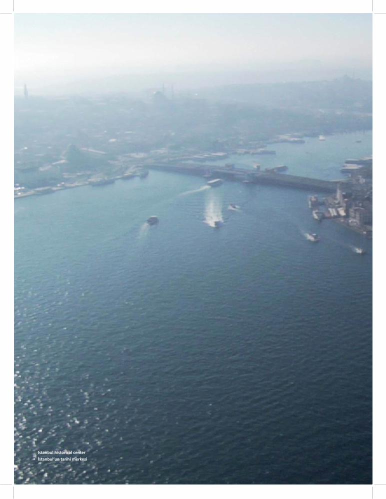
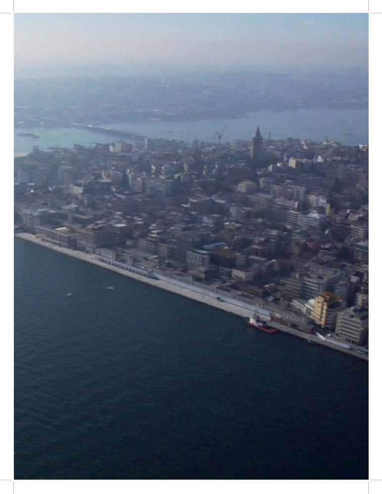
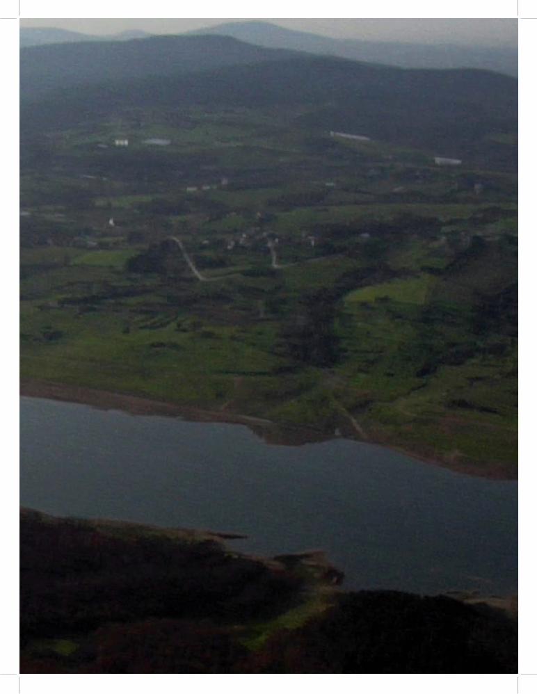
Istanbul historical centerİstanbul’un tarihi merkezi
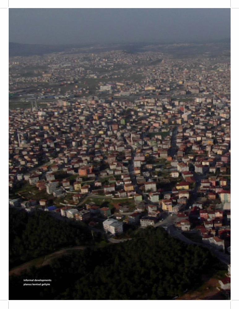
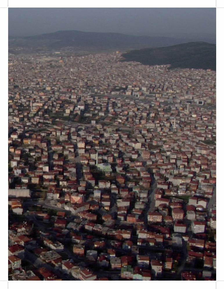
informal developmentsplansız kentsel gelişim
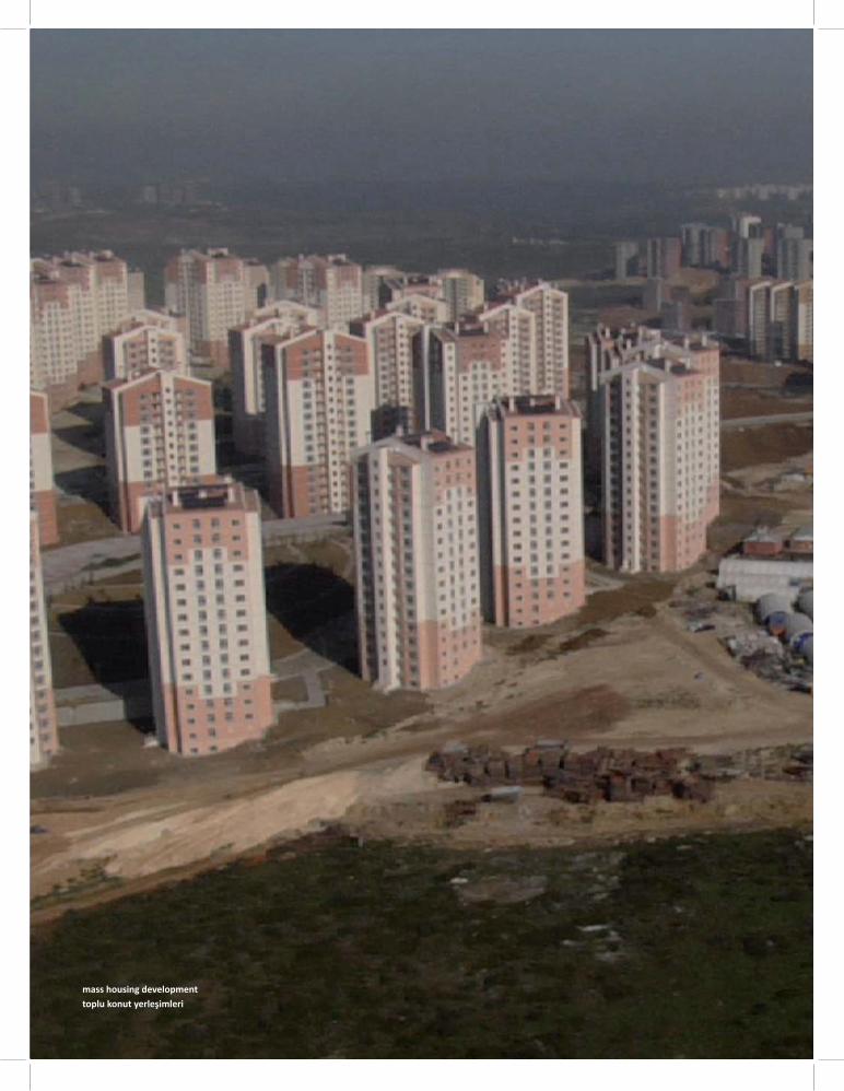
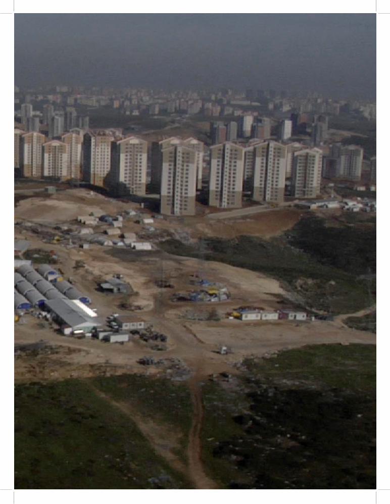
mass housing developmenttoplu konut yerleşimleri
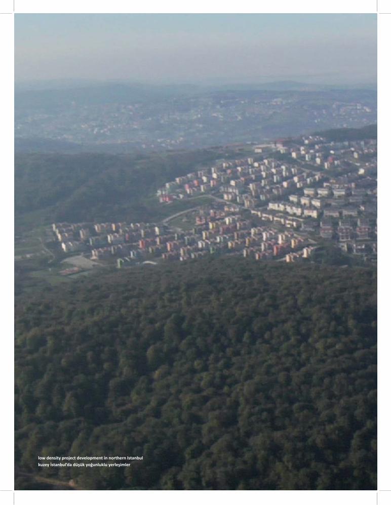
low density project development in northern Istanbulkuzey İstanbul’da düşük yoğunluklu yerleşimler
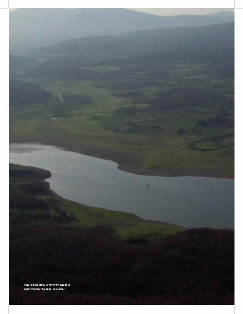
natural resources in northern Istanbulkuzey İstanbul’da doğal kaynaklar
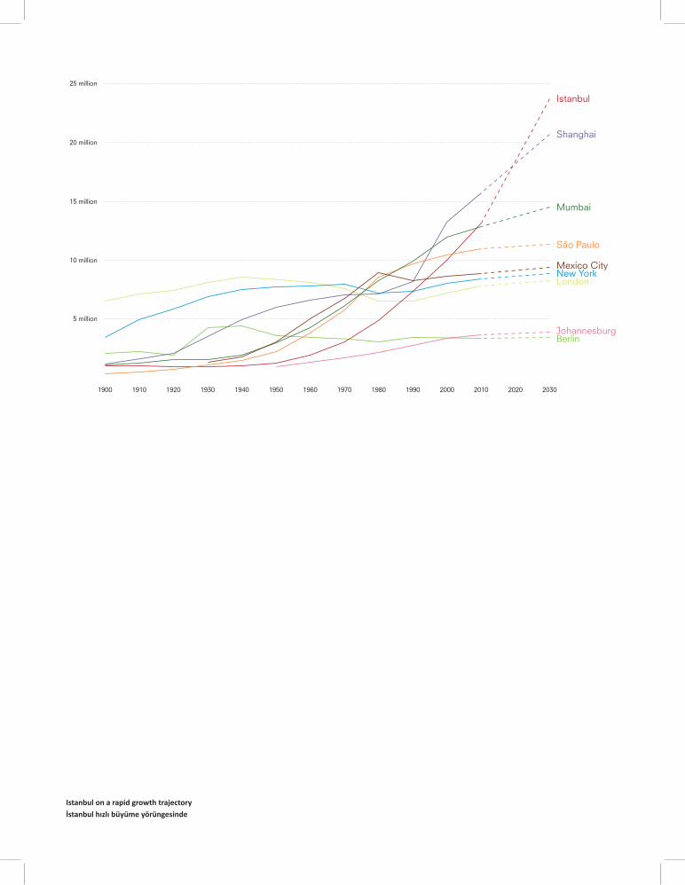
Istanbul on a rapid growth trajectory İstanbul hızlı büyüme yörüngesinde
1900
5 million
10 million
15 million
Istanbul
Shanghai
Mumbai
São Paulo
Mexico CityNew YorkLondon
JohannesburgBerlin
20 million
1910 1920 1930 1940 1950 1960 1970 1980 1990 2000 2010 2020 2030
25 million

Istanbul, a rapidly growing megacity
Istanbul became a megacity in 2000. Today at 13.6 million, its popula on is expected to rise to 22 million by 2023. The city is on a rapid growth trajectory. What is the meaning of a ‘sustainable’ city in such growth condi ons? Can the city s ll off er good life prospects to its inhabitants?
Hızla büyüyen megakent Istanbul
İstanbul 2000’de bir mega-kent haline geldi. Bugün 13.6 milyon olan nüfus, 2023’te tahminen 22 milyona ulaşacak. Kent hızlı bir büyüme yörüngesinde.
Bu büyüme koşullarında ‘sürdürülebilir kent’ ne anlama gelebilir? Kent, bu koşullarda kentlilere iyi bir yaşam sunabilir mi?
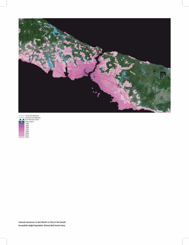
natural resources in the North vs CIty in the Southkuzeydeki doğal kaynaklar Güney’deki kente karşı
2nd Planned CanalNew Airport1400180019501970
3rd Planned Highway1st & 2nd Highway
1990200020102045
Resources under pressure
The city has been expanding drama cally in recent decades, following major new transporta on axes.Today, new large-scale projects are in prepara on: a third Bosporus bridge as part of the North Marmara Highway; new airports; transporta on infrastructures; and new areas for urban expansion. More and more city will be made.
In Istanbul, every northward expansion of the city puts huge pressure on essen al resources like clean air, water and arable land. Since O oman mes, a network of reservoirs has been providing the city with drinking water. This network is reaching its limits: If the consump on rate increases, Istanbul will soon have to import drinking water.
Baski Al ndaki Kaynaklar
Istanbul son yirmi –otuz yıldır birinci ve ikinci boğaz köprüleri bağlan yolları ve ana ulaşım aksları etra nda drama k bir genişleme yaşamakta. Bugün Kuzey Marmara Otoyolu kapsamında üçüncü bir Boğaz Köprüsü; yeni havaalanları; ulaşım altyapıları ve kentsel genişleme için yeni alanlar, gibi bir çok yeni ve büyük-ölçekli projeler hazırlanıyor. Kent katlana katlana büyüyor.
İstanbul’da, her kuzeye doğru büyüme tarımsal arazileri, ormanları ve su havzaları gibi temel kaynaklar üzerinde baskı yara yor.Osmanlı’dan beri, su barajları şebekesi kente içme suyu sağlamakta. Ancak bu şebeke sınıra dayanmış durumda. Eğer tüke m hızı artarsa, İstanbul yakında su ithala na gerek duyacak.
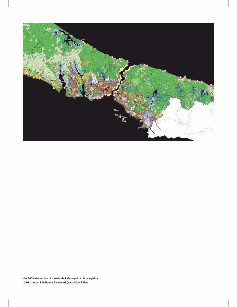
the 2009 Masterplan of the Istanbul Metropolitan Municipality2009 İstanbul Büyükşehir Belediyesi Çevre Düzeni Planı
Masterplan Istanbul 2023
The elaborate masterplan of 2009 acknowledges the threat to the sustainability of the city and tries to discourage further growth. It sets a recommended popula on limit of 16 million. The city, it says, should grow laterally along the Marmara Sea. In the north, forests and water zones should be protected and ecological agriculture and ecological tourism promoted.
Following the masterplan strategy for water basins protec on, gradient protec ve off sets are drawn around the reservoirs. Strict controls are carried out in these prohibited areas in order to eliminate trespassing se lements.
İstanbul 2023 Çevre Düzeni Plani
2009 yılında kabul edilen İstanbul Çevre Düzeni Planı ken n sürdürülebilirliğine ilişkin tehdi analizinin merkezine yerleş riyor ve ken n daha fazla büyümesinin önüne geçilmesi gerek ğini söylüyor. Planda önerilen nüfus limi 16 milyon. Plana göre, şehir Marmara Denizi boyunca yatay olarak büyümeli. Kuzeyde, ormanlar ve su bölgeleri korunmalı ve buralarda ekolojik tarım ve ekolojik turizm teşvik edilmeli.
Su havzalarının korunması için planlarda etrafl arına koruma bantları çekiliyor. Bu yasak alanlarda izinsiz yerleşimleri engellemek için konulan kurallar uygulanıyor.
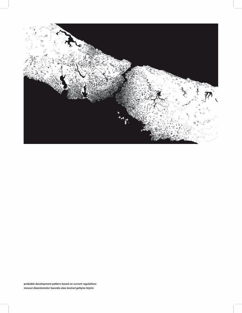
probable development pa ern based on current regula ons mevcut düzenlemeler bazında olası kentsel gelişme biçimi
Vision in confl ict with reality?
A comparison of the current protec on strategies and urban sprawl tendencies, however, raises ques ons about the future of the northern zone: in the absence of an integral vision, of coordina on, and of eff ec ve tools, urbaniza on will prevail over low-resistance territories.
Today, in northern Istanbul, regula ons are trying to limit growth by se ng a maximum density. Areas under urbaniza on pressure are growing by spreading across the terrain, and underu lized agricultural lands become targets for real estate developments.
Even if stricter regula ons manage to remove buildings from certain protected areas, what remains is the constant pressure of sprawl.
Gerçeklikle Çelişen Vizyon?
Mevcut koruma stratejileri karşısında kentsel yayılma eğilimlerine bakıldığında ken n kuzey bölgesinin geleceği ile ilgili soru işaretleri belirmekte: bütüncül bir vizyonun, paydaşlar -arası koordinasyonun ve etkili araçların yokluğunda kentsel yayılma, direnci düşük bu bölgeler üzerinde hakimiyet kuracak r.
Bugünkü mevcut plan düzenlemeleri maksimum yoğunluğu belirleyerek kuzey İstanbul’da büyümeyi sınırlandırmaya çalışıyor. Kentselleşme baskısı ise yeni alanlara yayılarak kendisini gösteriyor. Az kullanılan tarımsal araziler de bu baskıdan payını alıyor, gayrimenkul –odaklı ya rımların hedefi haline geliyor.
Kanunsuz yapılaşmalar koruma havzalarından kaldırılmaya çalışılsa bile, süreklilik taşıyan şey kentsel yayılma baskısı.
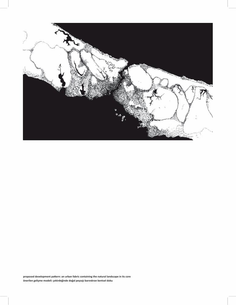
proposed development pa ern: an urban fabric containing the natural landscape in its coreönerilen gelişme modeli: çekirdeğinde doğal peyzajı barındıran kentsel doku

The Ridge City
With a sustainable future in mind, an alterna ve strategy is proposed: urban density is encouraged to take place along the narrow ridges of the water basins, leaving their core en rely free of se lement. Urban density and resource protec on are seen as indissociable components of a single system.
Sırt Ken
Sürdürülebilir bir geleceği göz önünde bulundurarak, bu projede alterna f bir strateji öneriliyor: su havzaları yerleşimden tamamen arındırılıyor ve kentsel yoğunluk havzaların dar sırtlarında konuşlandırılmaya teşvik ediliyor.Kentsel yoğunluk ve kaynakların korunması tek bir sistemin birbirinden ayrılmaz bileşenleri olarak değerlendiriliyor.
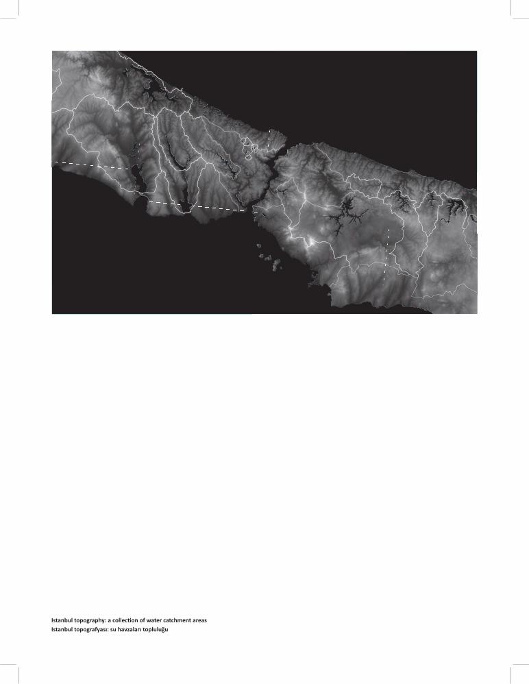
Istanbul topography: a collec on of water catchment areasIstanbul topografyası: su havzaları topluluğu
Opportunity #1: Topography
Two specifi c aspects of Istanbul are combined in the proposal. The fi rst involves the city’s topography: the characteris c relief of Istanbul consists of a vast system of ridges and basins, covering the en re region. The proposal reads Istanbul as a collec on of ‘cups’; this provides the appropriate development unit for the urgent issues of water protec on.
Birinci Firsat: Topoğrafya
İstanbul’un kendine has iki özelliği bu öneride birleş riliyor. İlki ken n topoğrafyası ile ilgili: İstanbul’un karakteris k rölyefi sırtlar ve havzalardan oluşan geniş bir sistemi içeriyor. Öneri, İstanbul topoğrafyasını ‘boy boy bir düzine kase’ gibi okuyor, bu da suyun korunmasıyla ilgili bir öneri geliş rmek için uygun bir yapılanma birimi.
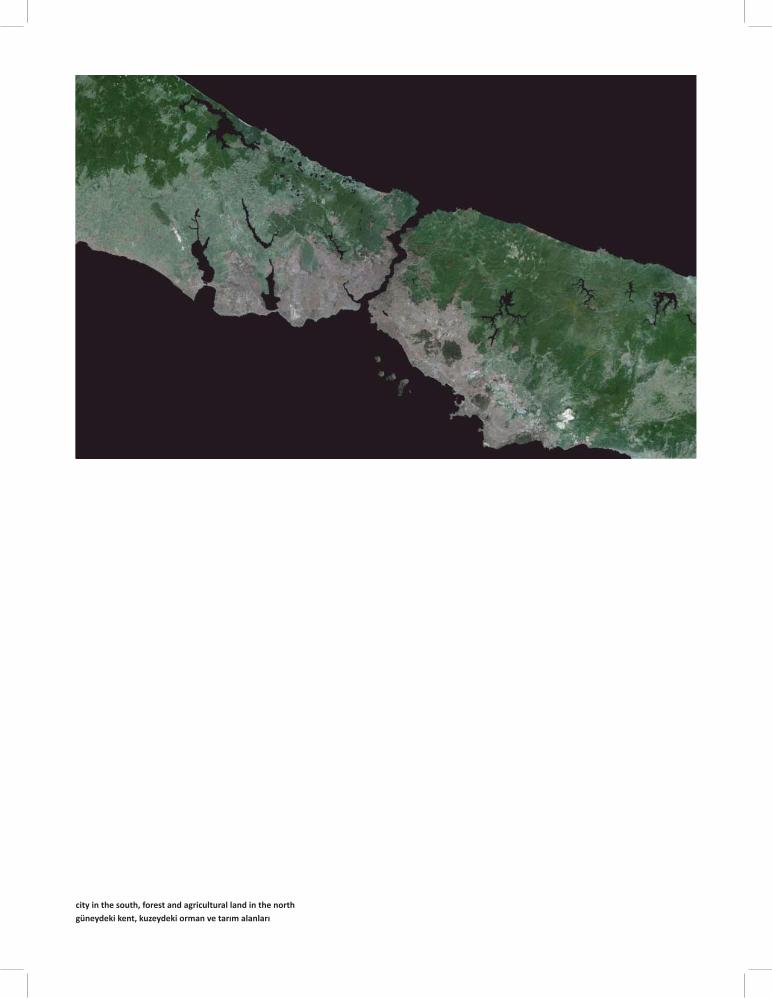
city in the south, forest and agricultural land in the northgüneydeki kent, kuzeydeki orman ve tarım alanları
Opportunity #2: Contrast
The second aspect is there in the macro- form of Istanbul: integral urbanized zones lay next to integral landscape zones.
The proposal applies this model at the scale of one basin, and inves gates an issue that has not hitherto been addressed: how the two zones can profi t from each other’s presence.
İkinci Firsat: Ayrimi
İkinci özellik ise İstanbul’un makro formundaki kentselleşme ve peyzaj arasındaki belirgin ayrım. Kendi içinde bütünlük taşıyan kentsel bölgeler, yine kendi içinde bütünlük taşıyan peyzaj bölgelerinin yanında uzanıyor.
Öneri, bir havza ölçeğinde bu özelliği ele alıyor ve bugüne kadar değinilmemiş bir konuyu araş rıyor: bu iki farklı bölge birbirlerinin varlığından nasıl faydalanabilir?
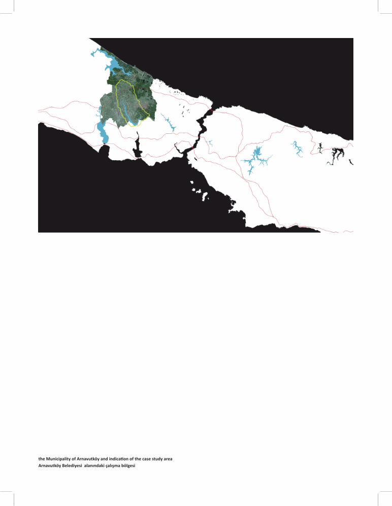
the Municipality of Arnavutköy and indica on of the case study areaArnavutköy Belediyesi alanındaki çalışma bölgesi
Arnavutköy
The study area is located beyond the edge of the city. It summarizes all the issues that Istanbul is currently facing: water basins; an exis ng highway to the south and the planned new highway in the north; housing and industrial development projects; and a very rapid urbaniza on process gradually taking over villages, rural lands and natural areas around them.
Today, Arnavutköy is in urgent need of strategies to proac vely channel and control the development pressure.
Arnavutköy
Çalışma alanı ken n kıyısının ötesinde konuşlanmış ve İstanbul’un son zamanlarda yüzleş ği tüm konuları özetliyor: su havzaları; güneye açılan mevcut bir otoyol ve kuzeyde planlanan yeni bir otoyol; iskan alanları ve endüstriyel yerleşmeler, hızlı kentselleşme ile günden güne dönüşen köyler, kırsal alan ve çevresindeki doğal alanları.
Arnavutköy bugün kentleşme baskısını ileriye dönük uzun soluklu bir perspek fl e kanalize etmek ve kontrol etmek için acil stratejilere ih yaç duymakta.
Strict protection zone / nature
Short range protection zone / ecological agriculture
Medium range protection zone / allowed pop.: 40p/ha (urban) 20p/ha (rural)
Long range protection zone / allowed pop.: 80p/ha (urban) 25p/ha (rural) Forest
RuralUrban
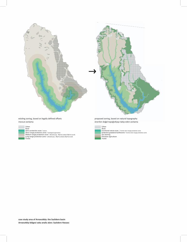
case study area of Arnavutköy: the Sazlidere basinArnavutköy bölgesi vaka analiz alanı: Sazlıdere Havzası
Functional nature zone / former strict range protection zone
Extensive grassland bufferzone / former short range protection zone
Dry farmingPrecision agriculture Forest
RuralUrban
exis ng zoning, based on legally defi ned off sets proposed zoning, based on natural topographymevcut zonlama önerilen doğal topoğrafyayı takip eden zonlama
Strategy #1: the Readable Landscape
The proposal takes up the gradient protec ve zones of the masterplan. It refi nes them by rela ng them back to natural topography. It shapes the landscape into zones with specifi c content and physical expression, to prevent land misuse. Subtle landscape elements form clear boundaries between the zones, and off er a variety of uses.
Birinci Strateji: Okunabilir Bir Peyzaj
Öneri, çevre düzeni planındaki koruma bantlarını doğal topoğrafya ile ilişkilendirerek rafi ne bir hale ge riyor; yerin koşullarına göre düzenliyor. Yanlış arazi kullanımını önlemek için, peyzajı içlerinde farklı içerik ve fi ziksel ifade içeren zonlar halinde şekillendiriyor. İncelikli peyzaj öğeleri bölgeler arasında belirgin sınırlar oluşturuyor ve birbirinden farklı kulllanımlar sunuyor.
average rainfall844mm/yr
5000 people urban wastewater=
100liter pp/day
Output: 10ha precision agriculture
ecological purification
(urban) run-off
City Agriculture
Reservoir
protectsprovides
irrigates
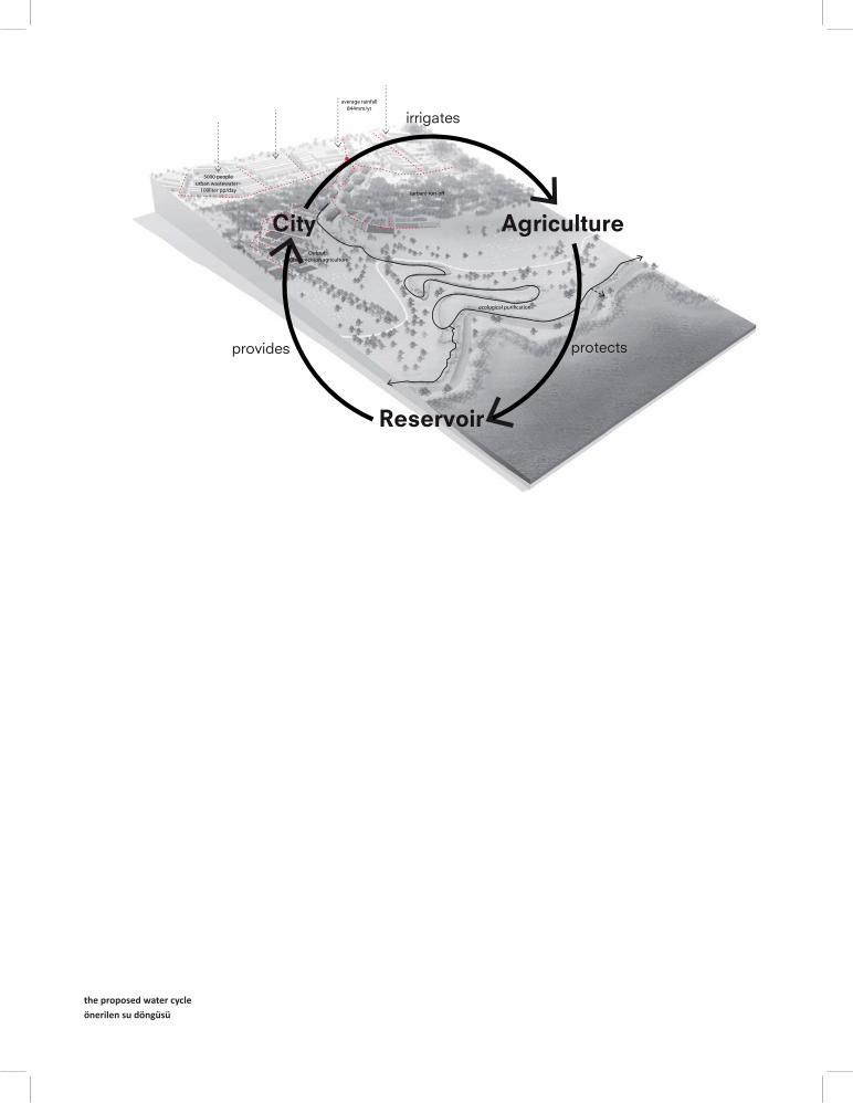
the proposed water cycleönerilen su döngüsü
Strategy #2: Closing the Water Cycle
A strong agricultural land use is vital in order to shield the basin against real estate specula on. However, with rainfall being insuffi cient and drinking water use precluded, agriculture today lacks water and has li le chance of survival. The future of the reservoir is also in danger.
An alterna ve water source is to be found in the city. Wastewater is not discharged into the sea, but treated and reused as irriga on water. The proposal closes the cycle: the city is the provider of necessary resources for agriculture. Produc ve agriculture is thereby able to resist sprawl, and thus protect the water basin, which in turn feeds the city with clean drinking water.
İkinci Strateji: Su Döngüsünü Kapatmak
Gayrimenkul spekülasyonuna karşı havzayı korumak için, güçlü bir tarımsal arazi kullanımı haya önem taşıyor. Ancak, yeterli yağış ve içme suyu kullanımının söz konusu olmaması nedeniyle, bugün tarım suya ulaşamamakta ve yaşama şansı maalesef çok az. Su barajının geleceği de tehdit al nda.
Buna karşıklık, alterna f su kaynağını şehrin kendisinde bulmak mümkün. Buna göre a k su denize boşal lmıyor, fakat arı lıp sulama olarak yeniden kullanılıyor. Öneri, döngüyü kapa yor: kent tarım için gerekli su kaynaklarının tedarikçisi oluyor. Üretken tarım böylece kentsel yayılmaya boyun eğmiyor, ve su havzasını koruyor. Korunan su havzası sonuçta şehri temiz içme suyu ile beslemeye devam ediyor
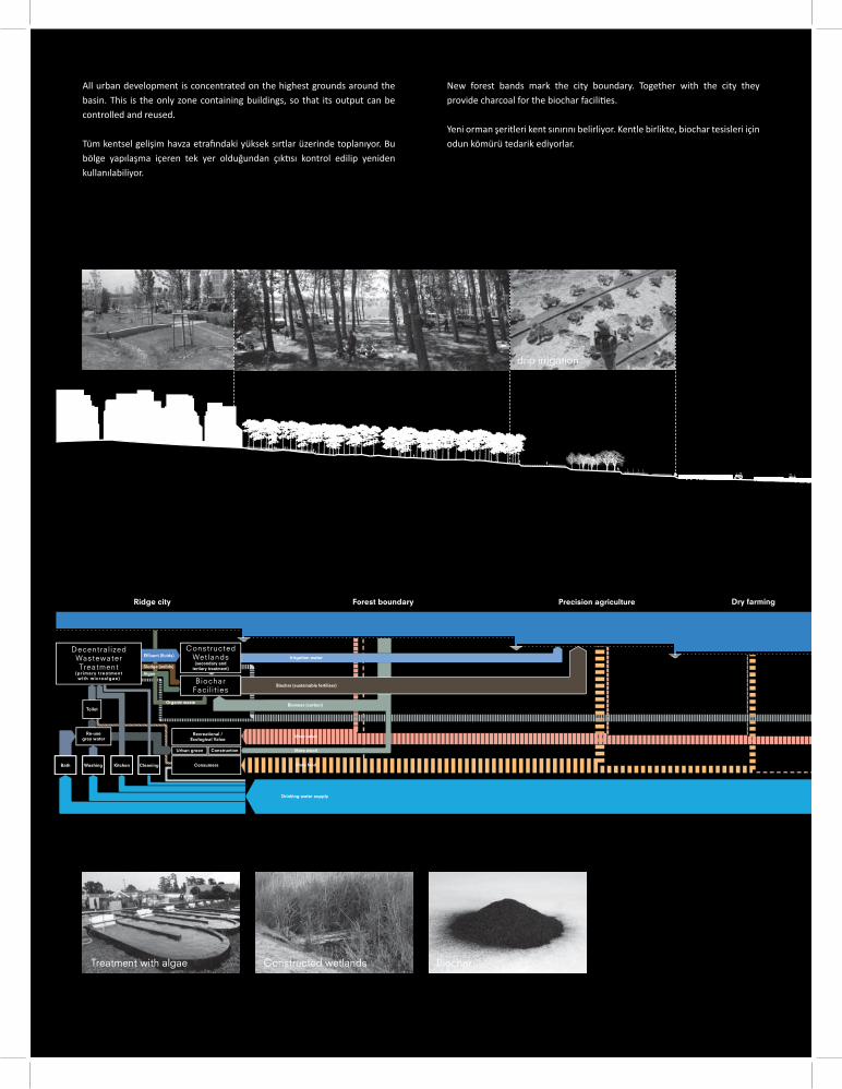
All urban development is concentrated on the highest grounds around the basin. This is the only zone containing buildings, so that its output can be controlled and reused.
Tüm kentsel gelişim havza etra ndaki yüksek sırtlar üzerinde toplanıyor. Bu bölge yapılaşma içeren tek yer olduğundan çık sı kontrol edilip yeniden kullanılabiliyor.
New forest bands mark the city boundary. Together with the city they provide charcoal for the biochar facili es.
Yeni orman şeritleri kent sınırını belirliyor. Kentle birlikte, biochar tesisleri için odun kömürü tedarik ediyorlar.
drip irrigation
Irrigation water
Drinking water supply
Re-use grey water
Consumers
Sludge (solids)
Effluent (fluids)
Organic waste
Algae
Biochar (sustainable fertiliser)
Biomass (carbon)
More food
More value
More wood
Kitchen CleaningWashingBath
Toilet
Biochar Faci l i t ies
Decentral izedWastewaterTreatment
(primary treatment with microalgae)
ConstructedWetlands
(secondary and tertiary treatment)
Urban green Construction
Recreational /Ecological Value
Ridge city Forest boundary Precision agriculture Dry farming
Treatment with algae Constructed wetlands Biochar
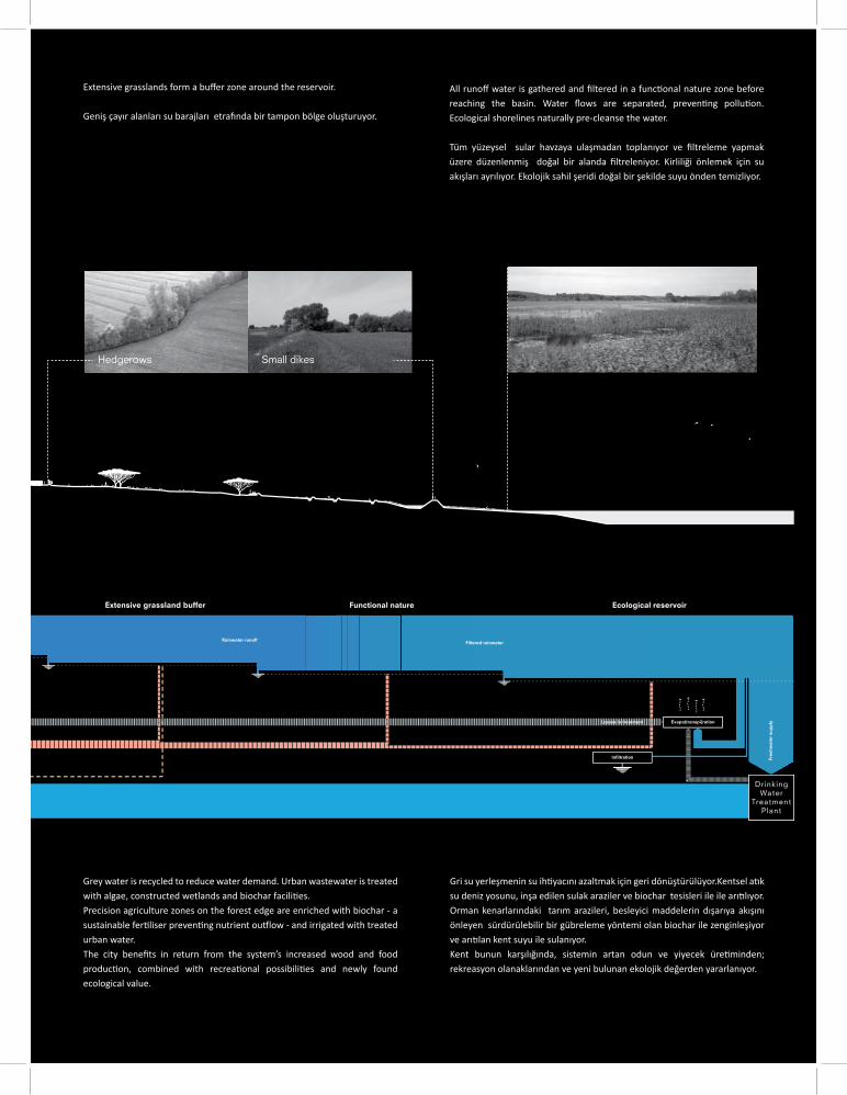
All runoff water is gathered and fi ltered in a func onal nature zone before reaching the basin. Water fl ows are separated, preven ng pollu on. Ecological shorelines naturally pre-cleanse the water. Tüm yüzeysel sular havzaya ulaşmadan toplanıyor ve fi ltreleme yapmak üzere düzenlenmiş doğal bir alanda fi ltreleniyor. Kirliliği önlemek için su akışları ayrılıyor. Ekolojik sahil şeridi doğal bir şekilde suyu önden temizliyor.
Grey water is recycled to reduce water demand. Urban wastewater is treated with algae, constructed wetlands and biochar facili es. Precision agriculture zones on the forest edge are enriched with biochar - a sustainable fer liser preven ng nutrient ou low - and irrigated with treated urban water. The city benefi ts in return from the system’s increased wood and food produc on, combined with recrea onal possibili es and newly found ecological value.
Gri su yerleşmenin su ih yacını azaltmak için geri dönüştürülüyor.Kentsel a k su deniz yosunu, inşa edilen sulak araziler ve biochar tesisleri ile ile arı lıyor.Orman kenarlarındaki tarım arazileri, besleyici maddelerin dışarıya akışını önleyen sürdürülebilir bir gübreleme yöntemi olan biochar ile zenginleşiyor ve arı lan kent suyu ile sulanıyor.Kent bunun karşılığında, sistemin artan odun ve yiyecek üre minden; rekreasyon olanaklarından ve yeni bulunan ekolojik değerden yararlanıyor.
Extensive grasslands form a buff er zone around the reservoir.
Geniş çayır alanları su barajları etra nda bir tampon bölge oluşturuyor.
Hedgerows Small dikes
Fre
shw
ate
r su
pp
ly
Filtered rainwater Rainwater runoff
Evapo(transpi)ration
Infiltration
Losses in treatment
Drinking Water
TreatmentPlant
Extensive grassland buffer riovreser lacigolocEerutan lanoitcnuF
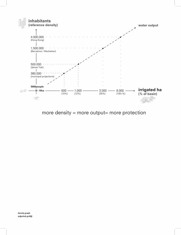
more density = more output= more protection
inhabitants(reference density) water output
500.000 (dense Toki)
380.000 (municipal projections)
1.000(12%)
3.000(35%)
8.000(100+%)
600(10%)
irrigated ha(% of basin)
5000people
1.500.000 (Barcalona / Manhattan)
4.000.000 (Hong Kong)
10ha=
density graphyoğunluk grafi ği
Produc ve density
The proposal works like a parametric equa on. If density augments, water output augments. In a paradoxical way, developing the city further ensures a more durable protec on of the basin.
Üretken Yoğunluk
Öneri, koşullu bir sabit (parametrik) denklem gibi işliyor. Eğer yoğunluk artarsa, su çık sı da artar. Paradoksal bir şekilde, şehri daha da geliş rmek, havzanın sürdürülebilir korunmasını da garan ediyor.
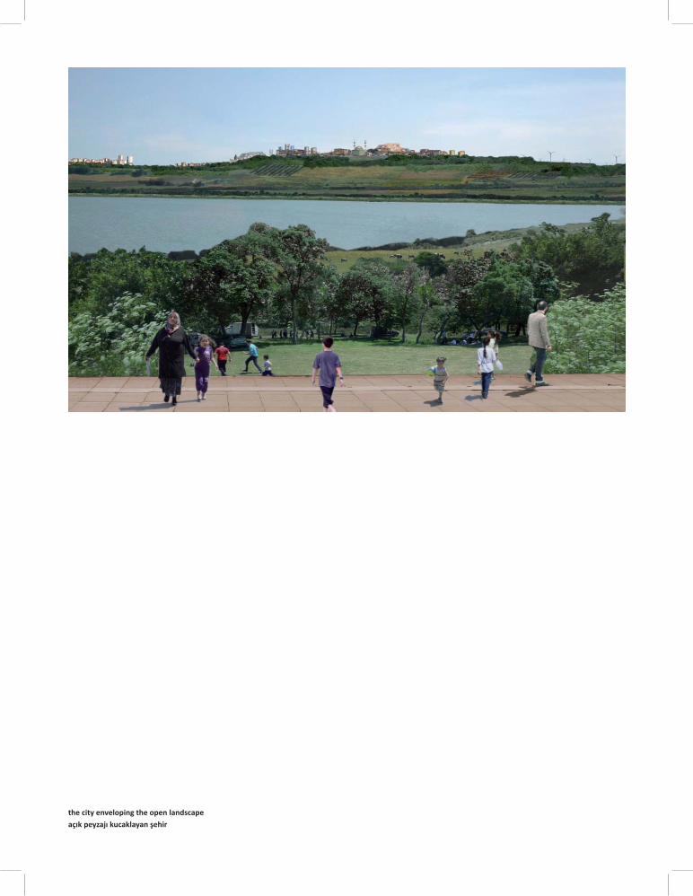
the city enveloping the open landscapeaçık peyzajı kucaklayan şehir
More Urban, More Landscape
In the end, concentra ng development in certain zones and keeping others se lement-free creates a very specifi c living condi on: a real urban environment complete with connec on possibili es and mixed use, but at the same me in direct rela on to an abundance of nature and a characteris c topography.
Daha Çok Kent, Daha Çok Peyzaj
Sonuçta, kentleşmeyi belli alanlarda yoğunlaş rmak ve diğer alanları yerleşime tamamen kapamak oldukça özgün bir yaşam çevresi yara r: gerçek bir kentsel çevre, ulaşım bağlan ları ve karma kullanım ile tamamlanır; fakat aynı zamanda doğanın bereke ve karakteris k topoğrafya ile birebir ilişki içerisindedir.
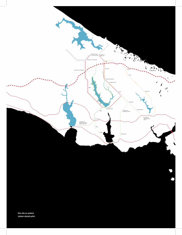
Ataturk Airport
Village
Harbor
Toki
Hadimkoy
Village
Connection to 3rd Highway
Connection to Terkos Basin
Forest
GokturkPicnic zone
Village
Arnavutkoy Expansion
Arnavutkoy Center
CVonnection to Buyukcekmece LakeBassin, coast road
Gated CommunityConnection toKaraburun
Basakeshir
Gaziolsmanpasa
Forest
Connection to Central Business District
Picnic zone
Connection to Istanbul City Center
Arnavutkoy South
Picnic zone
Village
the city as systemsistem olarak şehir
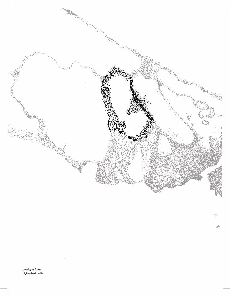
the city as formbiçim olarak şehir
An opera on, not a planning document
Currently, pilot sites are studied to test tools regarding me management; property rights management;
and cross-authority collabora ons. Unlike a plan, the strategic vision is about the steering of processes.
Bir plandan ziyade bir operasyon
Zaman yöne mi, mülkiyet hakları yöne mi ve çoklu-paydaş işbirlikleri gibi metodları sınamak için, pilot alanlar çalışması yapılıyor. Stratejik vizyon çalışması, bir plandan farklı olarak, süreçlerin yöne lmesini içeriyor.
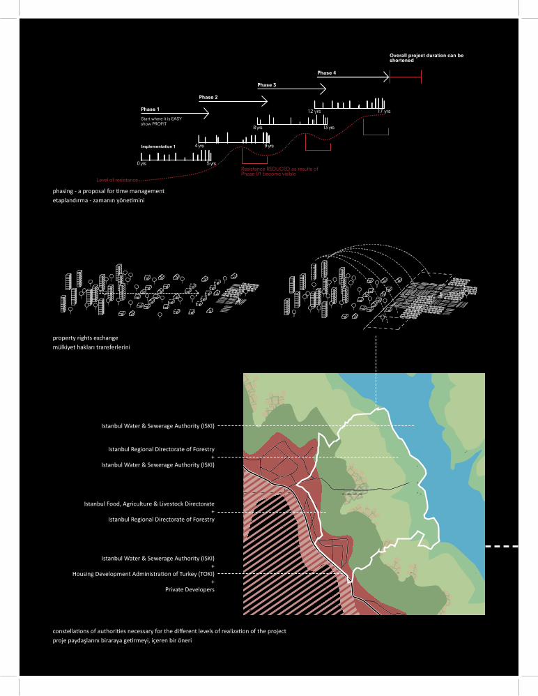
constella ons of authori es necessary for the diff erent levels of realiza on of the projectproje paydaşlarını biraraya ge rmeyi, içeren bir öneri
Implementation 1
Phase 1
sry 5sry 0
sry 9sry 4
17 yrs
Phase 2
Phase 3
Phase 4
Overall project duration can be shortened
12 yrs
sry 31sry 8
Level of resistance
Resistance REDUCED as results of Phase 01 become visible
Start where it is EASYshow PROFIT
Istanbul Water & Sewerage Authority (ISKI)
Istanbul Regional Directorate of Forestry+
Istanbul Water & Sewerage Authority (ISKI)
Istanbul Food, Agriculture & Livestock Directorate+
Istanbul Regional Directorate of Forestry
Istanbul Water & Sewerage Authority (ISKI)+
Housing Development Administra on of Turkey (TOKI)+
Private Developers
property rights exchangemülkiyet hakları transferlerini
phasing - a proposal for me managementetaplandırma - zamanın yöne mini
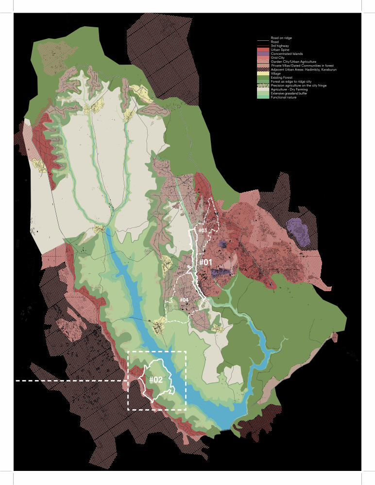
#02
#04
#01
#03
Urban SpineConcentrated IslandsGrid CityGarden City/Urban Agriculture
Adjacent Urban Areas: Hadimköy, Karaburun
Precision agriculture on the city fringe
Private Villas/Gated Communities in forest
VillageExisting ForestForest as edge to ridge city
Extensive grassland bufferAgriculture - Dry Farming
Functional nature
Road on ridge Road3rd highway
© 2012
51N4E Architects, Brussels, Belgium
H+N+S Landscape Architects, Amersfoort, the Netherlands
This project is supported by the Government of the Republic of Turkey within the framework of the celebra ons of the 400th anniversary of the establishment of diploma c rela ons between Turkey and the Netherlands.
Bu proje, Türkiye ile Hollanda arasındaki, diploma k ilişkilerin başlangıcının 400. Yıl dönümü kutlamaları çerçevesinde Türkiye Cumhuriye Hüküme tara ndan desteklenmiş r.
This work was commissioned by the Municipality of Arnavutköy and IABR in the context of the 5th IABR: Making City, Test Site Istanbul project. It was realised
by 51N4E and H+N+S Landscape Architects together with Architecture Workroom Brussels. The process of developing a Strategic Vision Plan for Arnavutköy
Municipality involved the ac ve par cipa on of the stakeholders and the municipality, and the exchange of exper se between Holland and Turkey.
Bu çalışma 5. IABR: Kent Yapmak, Test Bölge İstanbul projesi kapsamında, Arnavutköy Belediyesi ve IABR tara ndan yürütülmüştür.
51N4E ve H+N+S Peyzaj Mimarları ile Brüksel Mimarlık Atölyesi tara ndan gerçekleş rilmiş r.
Arnavutköy Belediyesi için Stratejik Vizyon Planı geliş rme süreci, paydaşların ve belediyenin etkin ka lımını ve Hollanda ile Türkiye arasındaki uzmanlık değiş-
tokuşunu kapsamaktadır.
51N4E Freek Persyn
Johan Anrys
Peter Swinnen
So ria Kornaropoulou
Vesna Jovanovic
Guido Brandi
Georgios E axiopoulos
H+N+S Landscape Architects/ H+N+S Peyzaj Mimarları Lodewijk van Nieuwenhuijze
Dirk Sijmons
Jaap van der Salm
Adam Hofl and
Joppe Veul
Test Site Istanbul Curator/ Test Bölge İstanbul Küratörü Asu Aksoy
Architecture Workroom Brussels/ Brüksel Mimarlık Atölyesi Joachim Declerck
Thomas Ca rysse
Interna onal Architecture Biennale Ro erdam/ Ro erdam Uluslararası Mimarlık Bienali George Brugmans
Joachim Declerck
Henk Ovink
Marieke Francke
Municipality of Arnavutköy/ Arnavutköy Belediyesi Ahmed Ha im Baltaci
Osman Akkaya
Gülnur Kadayifçi
Elif Korkmaz
Films lls/ Fotoğrafl arImre Balanli
Transla ons/ ÇevirilerAsli Kadayifci
With special thanks to the external experts and others involved.
Bu çalışmaya katkıda bulunan tüm uzmanlara ve emeği geçenlere özel teşekkürler ile.
A joint ini a ve of the Arnavutköy Municipality and the IABR in the context of the 5th IABR: Making City, the Atelier Istanbul was established in order to develop a Strategic Vision and Ac on Plan for Arnavutköy area that would recognize and integrate (instead of negate) both the forces of social, economic and urban transforma on and the ecological and environmental urgencies. By combining local and interna onal exper se and stakeholders, the Atelier produced a development vision, which laid out the much-needed tools and perspec ves to address the ques on of how to make the seemingly irreconcilable logics of urbaniza on and water and agriculture protec on work to one another’s benefi t. The Atelier developed an eff ec ve and opera onal strategic vision to manage, steer and guide urban transforma on and growth that would feed into the agricultural system, which in turn, contributed to the sustainability of the city.
5.Uluslararası Ro erdam Mimarlık Bienali (IABR): Kent Yapmak/Making City çalışması çerçevesinde Arnavutköy Belediyesi ve IABR ortaklığında oluşturulan Istanbul Atölyesi ken n karşı karşıya kaldığı sosyal, ekonomik ve kentsel dönüşümün ve büyümenin ken n giderek aciliyet kazanan ekolojik sürdürülebilirliğini sağlama arayışı ile nasıl bağdaş rılabileceğini ve sürdürülebilirliğin nasıl elde edileceğini Arnavutköy bölgesi bağlamında araş rarak ilçe için bir Stratejik Vizyon ve Eylem Planı geliş rmek üzere kuruldu.Yerel ve uluslararası uzmanları ve paydaşları biraraya ge ren Atölye Istanbul, birbirleriyle çelişiyor gibi görünen kentleşme dinamiğinin ve tarımsal arazilerin ve su havzalarının korunması gerekliliğinin birbirlerine katkı yapacak şekilde nasıl yöne lerek, yönlendirilebilecekleri ve şekillendirebileceklerini stratejik bir vizyon ile ortaya koydu. Tarımsal sisteme girdi sağlayan bir kentleşme modeli ile ken n sürdürülebilirliğinde önemli bir adım a ldı.