Embed Size (px)
Citation preview
35
172
1212
182
19
32 1 40
10
1
2
23
4
2
3
4
7
52
939
86
9
10292
291
1
13
14
PT1522
20
21
11
77
42
5261
72
51
34
13
12410071
123 151
42
311 3
4
212
38 14 1
60
432
431
614239
37
430
82
9
10
81
1
2
1
6
7581
73
41
18
26
42
159
55
402
621
4342
41
44
43
70
29
181
7
110
13
4710 66 144
5
113
13
11
13
108
6
88
60
60
3A
16
5
15
1
22315
5
4
51
6
1
41
41 40
2
2
35
35 12
3
7
7 25
33
6 33
301
49
49
62
12
12
56
39
48
12
69
69
7272
6202
202
201
108
11
11
5151
59 50
12595
46
46
4
13
17
57158
158
2
3
1
1
2
16
1
4
1
7
8
2
32
50
103
74
35
3
13
7
24
25
258
201
201
8
7
11
16
50
302
8
8
18
2
2
2
2
2
2
2
211
1
1
1
1
2
10
111
111
1 3
1
33
22
7301
1
2
2
2
1
11
50
4
1 23
DP 261226
DP 261226
DP 732024
DP 732024
DP 732024
DP 732024
DP 74
8810
DP 748810
DP 595987
DP 848802
DP 801440
DP 703164
DP 635645
DP 1002900
DP 1052985
DP 1052985
DP 1052985
DP 1052985
DP 635701
DP 871764
DP 871764
DP 871764
DP 634799
DP 2242
DP 742487
DP 861385
DP 861385
DP 607467
DP 726835
DP 712832
DP 712832
DP 746506
DP 752402
DP 752402
DP 752402
DP 752402
DP 752402
DP 752402DP 752402
DP 752402
DP 752402
DP 752402
DP 752402
DP 752402
DP 752402
DP 752402DP 752402
DP 752402
DP 752402DP 752402
DP 752402
DP 752402
DP 752402
DP 752402
DP 261530
DP 630255
DP 630255
DP 630255
DP 754397
DP 754397 DP 754397
DP 754397
DP 754397
DP 75
4397
DP 754397
DP 754397
DP 754397DP 754397
DP 754397
DP 754397
DP 754397
DP 754397
DP 754397DP 754397
DP 754397
DP 754397
DP 754397
DP 754397
DP 754397
DP 754397
DP 754397
DP 754397
DP 754397
DP 754397
DP 754397
DP 754397
DP 754397
DP 754397
DP 75
4397
DP 754397
DP 21
5862
DP 752417DP 752417
DP 752417
DP 752417
DP 752417
DP 752417
DP 588360
DP 255708
DP 260130
DP 813414
DP 110332
DP 653942
DP 754450
DP 754450
DP 754450
DP 754450
DP 754450
DP 754450
DP 754450
DP 754450
DP 754450
DP 754450
DP 754450
DP 754450DP 754450
DP 754450
DP 754450
DP 754450
DP 754450
DP 754450
DP 754450DP 754450
DP 754450
DP 754450
DP 754450
DP 754450DP 754450
DP 75
4450
DP 754450
DP 754450
DP 754450
DP 754450
DP 754450
DP 754450
DP 754450
DP 837648
DP 868135
DP 868135
DP 732082
DP 731025
DP 718032
DP 754425
DP 754425
DP 754425DP 754425
DP 754425
DP 754425
DP 754425
DP 754425
DP 754425
DP 754425
DP 754425
DP 754425
DP 754425
DP 754425 DP 754425
DP 754425DP 754425
DP 754425
DP 754425
DP 754425
DP 754425
DP 754425
DP 754425
DP 754425
DP 754425
DP 754425
DP 754425
DP 806234DP 621382
DP 623643
DP 716593
DP 608738
DP 752435
DP 752435
DP 752435
DP 543440
DP 54
3440
DP 104975
DP 104975
DP 1087504DP 1087504
DP 1087504
DP 1087504
DP 1052985
DP 1052985
DP 1052985
DP 1106595
DP 752435
DP 752435
DP 752435
DP 752435
DP 752435
DP 1111412
DP 1111412
DP 1111412
DP 752435
DP 752435
DP 752435
DP 752435
DP 1125182
DP 1126156
DP 1126156
DP 1126299DP 565993
DP 602742
DP 2242
DP 2242DP 2242
DP 2242DP 2242
DP 2242
DP 1135761
DP 1135761DP 1135761
DP 1135761DP 1135761
DP 1147190
DP 1160645
DP 1160645
DP 1160645
DP 1160645
DP 1156318
DP 1156318
DP 1159970
DP 11
87258
DP 1199019 DP 1199019
DP 1199019
DP 752435
DP 752435DP 752435
DP 752435
DP 752435
43
4545
49
56
5454
5353
52
43
52
5151
49
4848
4747
4646
56
454000mE(MGA)
470
460
460
47031º 07' 30" 31º 07' 30"
31º 15' 00" 31º 15' 00"
10'
35' 40'
35'
10'
40'
475000mE454000mE
475000mE
61
62
62
63 64
64
65
65
66
66
67
67
68
68
69
69 71
72
72
73
73
74
74
76
76
715753
53
55
55
56
56 6357
58
58
59
59
61152º 30' 00"
152º 30' 00" 152º 45' 00"
152º 45' 00"
6544000mN(MGA)
6555000mN6555000mN
6544000mN
65506550
TELEGRAPH POINT 21km
KEMPSEY 13km
TELEGRAPH POINT 20km
50
70
45
70
55
65
50
65
45
65
60
50
60
45
60
55
55
50
55
45
55
55
75
55
50
75
45
75
55
70
BALLENGARRASTATE
FOREST
BALLENGARRASTATE FOREST
BALLENGARRASTATE
FOREST
BALLENGARRASTATE
FOREST
BALLENGARRASTATE FOREST
YESSABAHSTATE
FOREST
YESSABAHSTATE
FOREST
KIPPARASTATE
FOREST
KIPPARASTATE
FOREST
MOUNT BOSSSTATE FOREST
MARIA RIVERSTATE FOREST
BALLENGARRASTATE
FOREST
KIPPARASTATE
FOREST
MOUNT BOSSSTATE
FOREST
MARIA RIVERSTATE FOREST
MARIARIVER STATE
FOREST
M A R L O
M E R R I C A NR I D G E
CPT
31/5
TRA IL
BALLENGARA ROAD
MOLLY MILLIGAN ROAD
NARANG ROAD
BONN
IE CO RNER
RD
LITTLES LOOP RD
COMBATINE CREEK RDC PT 31/6 TRAIL
EXTENSIONRD
COCKATOOLA
NE
BELLBIRD
TRAIL
ANDERSONSRO
AD
CPT 31/1 TRAIL
MACKAYSROAD
SPRING
HILL
ROAD
RE ADY
MONE
YRO
AD
SIDE
CUT
TRAIL
CLIFF TRAIL
BEAR
SRD
EXTENSION RD
CPT 28ROAD
COGO
LN
MYER
SLAN
E
MAROWIN
BROO
K
RD
DURIE
S
ROAD
FOWLERS
TRAIL
GOANNA ROAD
ROCKYRD
CPT3 1/3
TRAIL
DEAN
S
ROAD
BEARS ROAD
CONVICTROAD
CONNECTION
RD
ACCESS
ROAD
CPT
31/4 TRAIL
BULLOCKROAD
HELLCREEK ROAD
NORTH
WILSONROAD
SAPLING
CREEKRD
CORKWOOD TRAIL
ROCKY RD
CPT 31/2 TRAIL
FIREROAD
LIGHTNING TRAIL
STOC
KYAR
D
TRAIL
SIDE CUTTRAIL
MAIN RANGE TRAIL
MAIN RANGETRAI L
SHORTCU
TTR
AIL
LONG
FLAT
CREE
KRD
HUT
ROAD
HUTRD
KOGOROAD
PIPER
SCR
EEK
ROAD
PIPER S
CREEK ROAD
YAMM
ACOO
NA
WAY
TUCKYBUNYUBAH ROAD
OLD
ROLLA
NDS PLAINS ROAD
OLDROLLANDS
PLAINSRD
FOWLERS
TRAIL
FOWLERS
TRAIL
RISSAS ROAD
SILO
RD
PURCHASE ROAD
MIDDLEVALLEY
RD
JENNINGS
RD
DURIES
TRAIL
DURIE
STRAIL
CUT FENCE RD
COBRABALD ROAD
PURCHASEROAD
PUR CHASEROAD
BARR
ACKS
ROAD
BARRACKS
RD
BOWERBIR
DLAN
E
MIDDLERIDGE
TRAI L
MAINRANGE
TRAIL
PERCH ESFIRETRA IL
MILL
T RAIL
MARLA ROAD
TINEBANK TRAIL
COOK
SRO
AD
UPPER
ROLLANDS PLAINS ROAD
locked
locked
locked
lockedlocked
locked
200
200
800
300
300
200
300
700
800
300
900
100
700
600
400
40
30
500
40
700
700
800
800
20
300
400200
300
300
500
100
50
50
50
50
300
200
100
500
200
100
200
200
500
200
100
200
30
200
100
100
100
300
40
40
50
100
400
50
300
100
50
200
200
500
200
200
200100
300
500
30
50
200
100
100
100
100
300
400
300
40
200
200
300
200
800
200
100
400
300
100
200
800
40
200
200
40
200
300
200
50
100
40
50
200
200
200
200
200
200
200
200
200
200
200
200
200
100
100
100
100
500
100
200
300
400
40
30
200
200
200
200
200
400
300
100
100
100
100
600
300
300
300
300
300
300
400
200
200
200
100
500
500
500
400
400
400
400
300
300
300
300
200
200
200
200
300
900
200
100
100
100
100
100
100
100
100
100
100
300
300
600
600
600
400
200
300
300
50
300
700
500
200
400
100
400
100
40
200
200
400
50
50
100400
400
quarry
yards
yards
yards
yards
yards
yards
yards
yards
yards
yards
yards
yards
yards
yardsyards
yards
yards
yards
yards
yards
yards
yards
yards
yardsyards
yards
silo
silo
silo
silo
pump
pumppump
pump
pump
pump
pumppump
pump
pump
pump
pump
pump
pump
pump
observationtower
ruins
hayshed dairyshed
ruins
ruin
ruins
hayshed
ruins
ruins
hayshed
toiletssilo
ford
ford
ford
fordford
ford
fordford
ford
ford
ford
ford
ford
ford
ford
ford
ford
ford
ford
ford
ford
ford
ford
ford
fordford
ford
ford
ford
ford
ford
ford
ford
ford
ford
fordford
ford
ford
ford
ford
ford
ford
ford
ford
ford
ford
ford
CobrabaldCreek
Tinebank Creek
Sap lingCreek
Pie Mountain Creek
Upper
Gulgo
Creek
Euroka Creek
Smiths Creek
Long
Flat
Creek
Adelaid
e Bro
ok
Ready
Money
Creek
Gulgo Creek
Geary Creek
Kogo Creek
Combat
ine
Creek
Casw
ellsCre
ek
Kumbatine Creek
Stockyard
Creek
PipersCreek
MarloMerri can
Creek
MarloM errican
Creek
GlencoeCreek
Glencoe Creek
WILSON RIVER
WILSONRIVER
WILLI WILLINATIONAL
PARK
WILLI WILLINATIONAL PARK
WILLI WILLINATIONAL
PARK
KUMBATINENATIONAL
PARK
KUMBATINENATIONAL
PARK
KUMBATINENATIONAL PARK
KUMBATINENATIONAL
PARK
KUMBATINENATIONAL PARK
KUMBATINENATIONAL
PARK
KUMBATINENATIONAL PARK
KUMBATINENATIONAL PARK
KUMBATINENATIONAL
PARK
KUMBATINENATIONAL PARK
KUMBATINE STATECONSERVATION AREA
KUMBATINENATIONAL PARK
KUMBATINENATIONAL
PARK
Kogo
PlacidTrees
Hintadupfing
Wirrabara
Milesaway
Kipparra
Warrabee
LittleTilba
Leumeah
Sentosa
Torulosa
Rainbows End
Alanvale
BurraBurraAlaya
Glenshiel
Clearfield
Yakatoon
Alendale
Weeroona
Serendipity
621
327
957
446
344
486
382
158
184
343
346
284
314
181
352
426
132
229
73
125
241
37
199
325
83
138
327
GEARYSMOUNTAIN
MOUNTKIPPARA
TINEBANKMOUNTAIN
TUCKYBUNYUBAHMOUNTAIN
G E A R Y S F L AT
K I P PA R A
M A R L O M E R R I C A N
U P P E RR O L L A N D S
P L A I N S
K E M P S E Y
K E M P S E Y
K E M P S E Y
P O R TM A C Q U A R I E - H A S T I N G S
Ballengarra
Kogo
311
570
W
S
bore
THIS
MAP M
AY C
ONTA
IN A
UTOM
ATIO
N IN
DUCE
D ER
RORS
OR
OMIS
SIONS
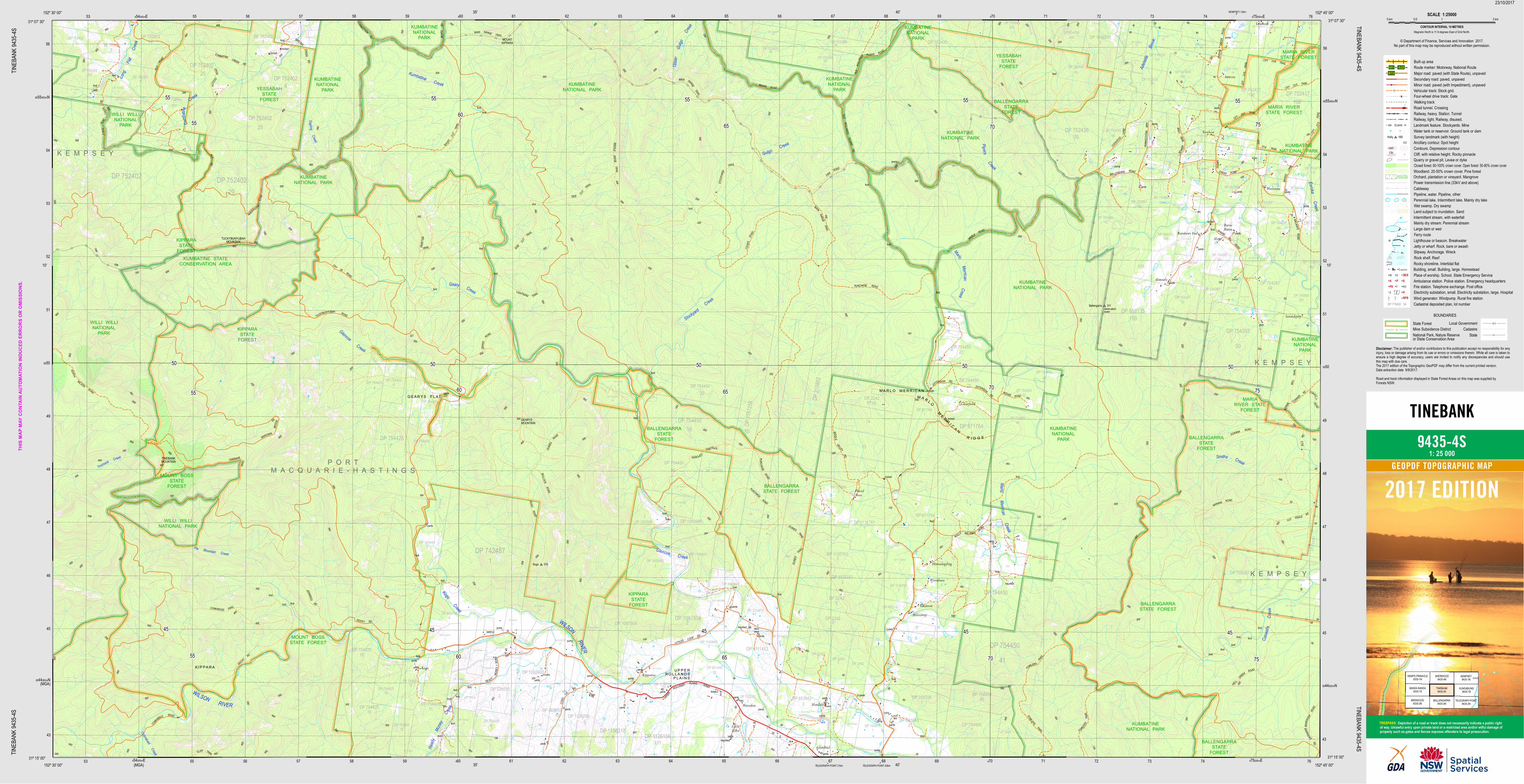
.CONTOUR INTERVAL 10 METRES
Magnetic North is 11.9 degrees East of Grid North.
© Department of Finance, Services and Innovation 2017.No part of this map may be reproduced without written permission.
TINEBANK
9435-4S
23/10/2017
TINEB
ANK 9
435-4S
TINEB
ANK 9
435-4S
TINEBANK 9435-4STINEBANK 9435-4S
2017 EDITION
The publisher of and/or contributors to this publication accept no responsibility for anyinjury, loss or damage arising from its use or errors or omissions therein. While all care is taken toensure a high degree of accuracy, users are invited to notify any discrepancies and should usethis map with due care.The 2017 edition of the Topographic GeoPDF may differ from the current printed version.Data extraction date 9/9/2017.Road and track information displayed in State Forest Areas on this map was supplied byForests NSW.
Disclaimer:
1: 25 000GEOPDF TOPOGRAPHIC MAP
Depiction of a road or track does not necessarily indicate a public rightof way. Unlawful entry upon private land or a restricted area and/or wilful damage ofproperty such as gates and fences exposes offenders to legal prosecution.TRESPASS:
KEMPS PINNACLE9335-1N
SHERWOOD9435-4N
KEMPSEY9435-1N
BANDA BANDA9335-1S
TINEBANK9435-4S
KUNDABUNG9435-1S
BIRDWOOD9335-2N
BALLENGARRA9435-3N
TELEGRAPH POINT9435-2N
KOROGORO POINT 9535-4N
Built up areaRoute marker: Motorway, National RouteMajor road: paved (with State Route), unpavedSecondary road: paved, unpavedMinor road: paved (with Impediment), unpavedVehicular track: Stock grid.Four-wheel drive track: GateWalking trackRoad tunnel. CrossingRailway, heavy. Station. TunnelRailway, light. Railway, disused.Landmark feature. Stockyards. MineWater tank or reservoir. Ground tank or damSurvey landmark (with height)Ancillary contour. Spot heightContours. Depression contourCliff, with relative height. Rocky pinnacleQuarry or gravel pit. Levee or dykeClosed forest: 80-100% crown cover. Open forest: 50-80% crown coverWoodland: 20-50% crown cover. Pine forestOrchard, plantation or vineyard. MangrovePower transmission line (33kV and above)CablewayPipeline, water. Pipeline, otherPerennial lake. Intermittent lake. Mainly dry lakeWet swamp. Dry swampLand subject to inundation. SandIntermittent stream, with waterfallMainly dry stream. Perennial streamLarge dam or weirFerry routeLighthouse or beacon. BreakwaterJetty or wharf. Rock, bare or awashSlipway. Anchorage. WreckRock shelf. ReefRocky shoreline. Intertidal flatBuilding, small. Building, large. HomesteadPlace of worship. School. State Emergency ServiceAmbulance station. Police station. Emergency headquartersFire station. Telephone exchange. Post officeElectricity substation, small. Electricity substation, large. Hospital
Local GovernmentState Forest
StateCadastreMine Subsidence District
National Park, Nature Reserveor State Conservation Area
BOUNDARIES
silo yards
Holly 169123
176r1000
Lauren
ZZ
W S SESA P EFS T PO
SCALE 1:250000 km 2 km 10.5
HRFS Wind generator. Windpump. Rural fire station
M1 A32B72
Cadastral deposited plan, lot numberDP 779432 34