Embed Size (px)
Citation preview
Acta Geodyn. Geomater., Vol. 8, No. 3 (163), 325–333, 2011
LANDSLIDES MAPPING IN ROZNOW LAKE VICINITY, POLAND USING AIRBORNE LASER SCANNING DATA
Andrzej BORKOWSKI 1)*, Zbigniew PERSKI 2), Tomasz WOJCIECHOWSKI 2), Grzegorz JÓŹKÓW 1) and Antoni WÓJCIK 2)
1) Wroclaw University of Environmental and Life Sciences, Institute of Geodesy and Geoinformatics,
Grunwaldzka 53, 50-357 Wrocław, Poland 2) Polish Geological Institute – National Research Institute. Carpathian Branch, Skrzatow 1, 31-560 Cracow,
Poland *Corresponding author‘s e-mail: [email protected] (Received January 2011, accepted August 2011)
ABSTRACT Southern Poland, especially Polish Carpathians, is a region affected by strong mass-movements. The importance of mass-movements problems has been taken into consideration on the governmental level and Landslide Counteracting System(SOPO) program was launched in 2008. The main purpose of this program is to create inventory and map all active andinactive landslides and landslide prone areas in Poland. However, in case of such gigantic work, the traditional mapping methods meet sometimes their limitations. In order toovercome some of efficiency problems the new technology, the application of airborne laser scanning was tested. The main purpose of presented work is to test whether the LiDAR DTM is capable to support geological interpretation andlandslide detection on steep and forested slopes for the purposes of landslide mapping within SOPO project. For this purposethe ALS dataset covering 40 km2 of the area near Roznow Lake in Polish Carpathians have been acquired in April 2010. Theaverage scanning resolution was 7 points/m2 and LiteMapper 6800i system based on the full waveform, Riegl LMS-Q680iscanner have been used. Acquired point cloud was applied to generate DTM of 0.5 m resolution. For efficiency test purposesthe detailed geological interpretation of constructed ALS DTM was focused on already well mapped large Zbyszycelandslide. The extents of the landslide and the zones of different level of activity have been mapped and then verified withfield data. During the detailed analysis it was found that the level of the details of ALS DTM allows also performingmorphometric analysis on landslides. KEYWORDS: Airborne laser scanning, landslides, landslides mapping, Carpathians
for ALS data processing. Moreover, due to increasing popularity it becomes more cost-effective and available for new applications. One of them is the landslides mapping and monitoring. The first attempt to apply ALS and also TLS (Terrestrial Laser Scanning) data for landslide research are in fact carried out since there technologies have become widely available (Carter et al., 2001; Haugerud et al.,2003). A good overview about recent achievements in this field has been given recently by Jaboyedoff et al.(2010).
The problem of mass movements occurs with particular intensity in the southern Poland. Over 95 % of landslides are located in Carpathian region (Poprawa and Rączkowski, 2003). The importance of landslide problem which directly affects local communities was recognized several years ago at the central level by creating “Landslide Counteracting System” (SOPO) (Grabowski, 2008). The main goal of this project is to create digital database of all active and inactive landslides and landslide prone areas. Most efforts within SOPO project is devoted to detailed field mapping of landslides and recognition of landslide-prone areas. Traditionally, the time-consuming field works are followed by the analysis of contour maps and aerial photos. Recently, similar
1. INTRODUCTION Airborne Laser Scanning (ALS), referred also as
LiDAR (Light Detection and Ranging) has become inrecent years the leading technique for obtaininginformation about the terrain surface topography, thatis required for Digital Terrain Models (DTM)construction. In respect to the traditional dataacquisition techniques, ALS removes a number oflimitations that affects traditional methods. The mainadvantages are: • Uses of an active sensor in the form of a narrow
laser beam with high penetration capabilityallowing that the measurements are independentof weather conditions and time of a day;
• The high penetration rate of laser signal indensely vegetated (wooded) areas could be up to 70 % assure that many of reflections come fromthe terrain surface (Ackermann, 1999). In suchareas all the traditional measurement techniquesusually fail;
• Obtained data are characterized by the highdensity, even tens of points per square meter with high vertical precision from about 0.1 to 0.3 m.
ALS technologies develop very fast in terms ofscanners efficiency and improvement of algorithms
A. Borkowski et al.
326
(2004) used airborne laser scanning for micro topography mapping and tested the capability of the ALS-data against contour map and aerial photos interpretation. In the paper of Baldo et al. (2009) a complex translational landslide was monitored using an experimental system based on terrestrial LiDAR and GPS. Chigira et al. (2004) used an airborne laser scanner to survey an area of the 1998 Fukushima disaster, where more than 1,000 shallow landslides occurred on slopes of vapor-phase crystallized ignimbrite overlain by permeable pyroclastics. The authors identified landslides that have occurred at the event and also detected previous landslides that were hidden by vegetation. In almost all mentioned studies, the ALS data were used as a supplementary data, to identify and visualize landslides range. However using new type of scanners with increased scanning resolution, the potential of ALS data seems to be widely greater in terms of landslide studies.
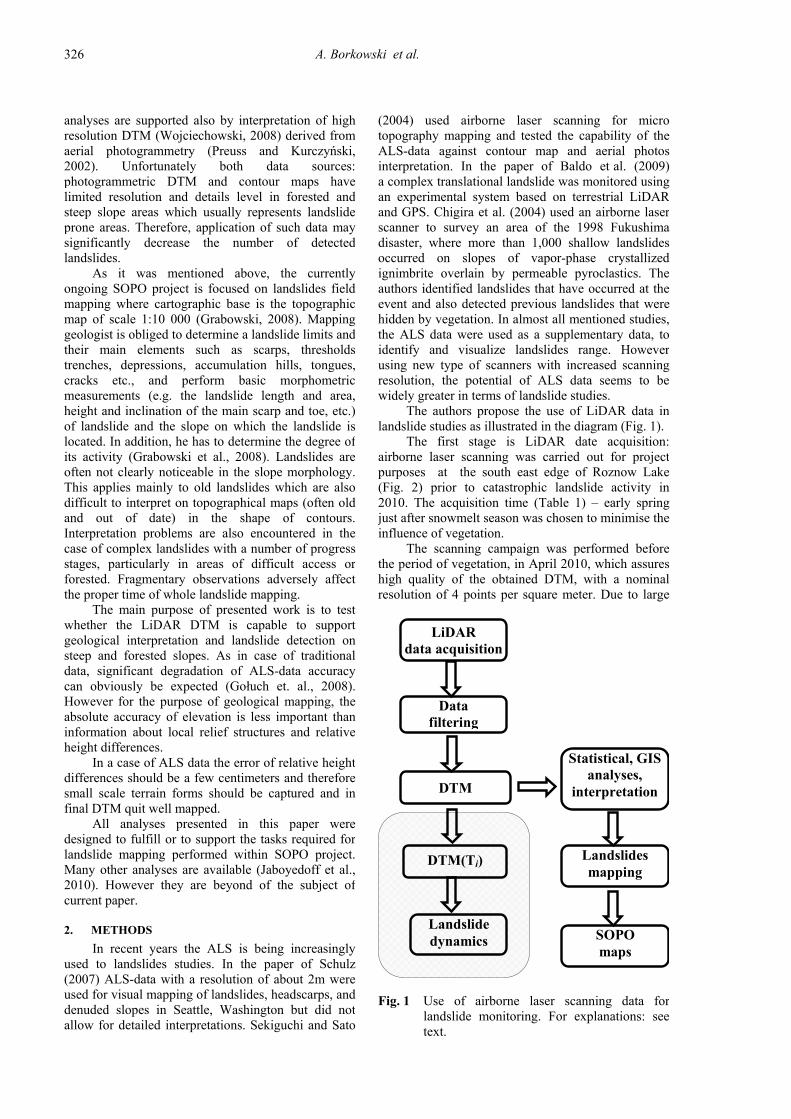
The authors propose the use of LiDAR data in landslide studies as illustrated in the diagram (Fig. 1).
The first stage is LiDAR date acquisition: airborne laser scanning was carried out for project purposes at the south east edge of Roznow Lake (Fig. 2) prior to catastrophic landslide activity in 2010. The acquisition time (Table 1) – early spring just after snowmelt season was chosen to minimise the influence of vegetation.
The scanning campaign was performed before the period of vegetation, in April 2010, which assures high quality of the obtained DTM, with a nominal resolution of 4 points per square meter. Due to large
analyses are supported also by interpretation of highresolution DTM (Wojciechowski, 2008) derived fromaerial photogrammetry (Preuss and Kurczyński,2002). Unfortunately both data sources:photogrammetric DTM and contour maps havelimited resolution and details level in forested andsteep slope areas which usually represents landslideprone areas. Therefore, application of such data maysignificantly decrease the number of detectedlandslides.
As it was mentioned above, the currentlyongoing SOPO project is focused on landslides fieldmapping where cartographic base is the topographicmap of scale 1:10 000 (Grabowski, 2008). Mappinggeologist is obliged to determine a landslide limits andtheir main elements such as scarps, thresholdstrenches, depressions, accumulation hills, tongues,cracks etc., and perform basic morphometricmeasurements (e.g. the landslide length and area,height and inclination of the main scarp and toe, etc.)of landslide and the slope on which the landslide islocated. In addition, he has to determine the degree ofits activity (Grabowski et al., 2008). Landslides areoften not clearly noticeable in the slope morphology. This applies mainly to old landslides which are alsodifficult to interpret on topographical maps (often oldand out of date) in the shape of contours.Interpretation problems are also encountered in thecase of complex landslides with a number of progress stages, particularly in areas of difficult access orforested. Fragmentary observations adversely affectthe proper time of whole landslide mapping.
The main purpose of presented work is to testwhether the LiDAR DTM is capable to supportgeological interpretation and landslide detection onsteep and forested slopes. As in case of traditionaldata, significant degradation of ALS-data accuracycan obviously be expected (Gołuch et. al., 2008).However for the purpose of geological mapping, theabsolute accuracy of elevation is less important thaninformation about local relief structures and relativeheight differences.
In a case of ALS data the error of relative heightdifferences should be a few centimeters and thereforesmall scale terrain forms should be captured and infinal DTM quit well mapped.
All analyses presented in this paper weredesigned to fulfill or to support the tasks required forlandslide mapping performed within SOPO project.Many other analyses are available (Jaboyedoff et al.,2010). However they are beyond of the subject ofcurrent paper.
2. METHODS
In recent years the ALS is being increasinglyused to landslides studies. In the paper of Schulz(2007) ALS-data with a resolution of about 2m wereused for visual mapping of landslides, headscarps, and denuded slopes in Seattle, Washington but did notallow for detailed interpretations. Sekiguchi and Sato
Landslide dynamics
Landslides mapping
Data filtering
DTM
Statistical, GIS analyses,
interpretation
DTM(Ti)
SOPO maps
LiDAR data acquisition
Fig. 1 Use of airborne laser scanning data for landslide monitoring. For explanations: see text.
LANDSLIDES MAPPING IN ROZNOW LAKE VICINITY, POLAND USING AIRBORNE ….
327
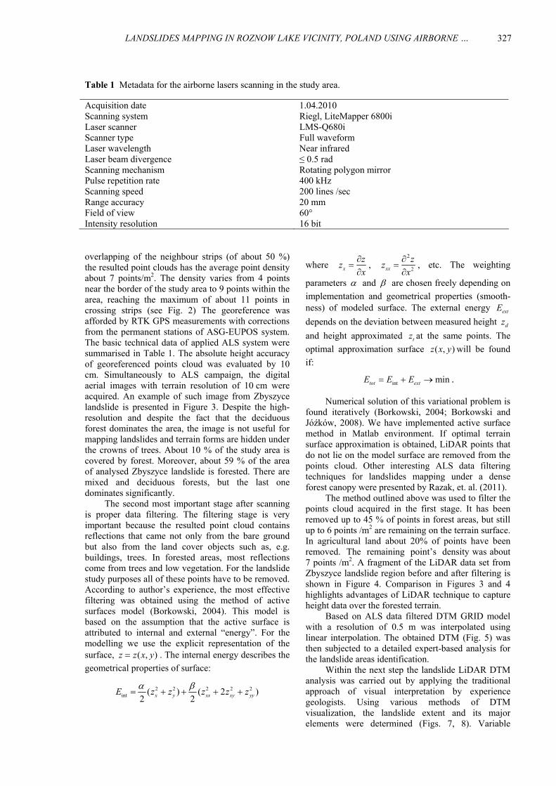
Table 1 Metadata for the airborne lasers scanning in the study area.
Acquisition date 1.04.2010 Scanning system Riegl, LiteMapper 6800i Laser scanner LMS-Q680i Scanner type Full waveform Laser wavelength Near infrared Laser beam divergence ≤ 0.5 rad Scanning mechanism Rotating polygon mirror Pulse repetition rate 400 kHz Scanning speed 200 lines /sec Range accuracy 20 mm Field of view 60° Intensity resolution 16 bit
where xzzx∂
=∂
, 2
2xxzz
x∂
=∂
, etc. The weighting
parameters α and β are chosen freely depending on implementation and geometrical properties (smooth-ness) of modeled surface. The external energy extEdepends on the deviation between measured height dzand height approximated tz at the same points. The optimal approximation surface ( , )z x y will be found if:
int mintot extE E E= + → .
Numerical solution of this variational problem is found iteratively (Borkowski, 2004; Borkowski and Jóźków, 2008). We have implemented active surfacemethod in Matlab environment. If optimal terrain surface approximation is obtained, LiDAR points that do not lie on the model surface are removed from the points cloud. Other interesting ALS data filtering techniques for landslides mapping under a dense forest canopy were presented by Razak, et. al. (2011).
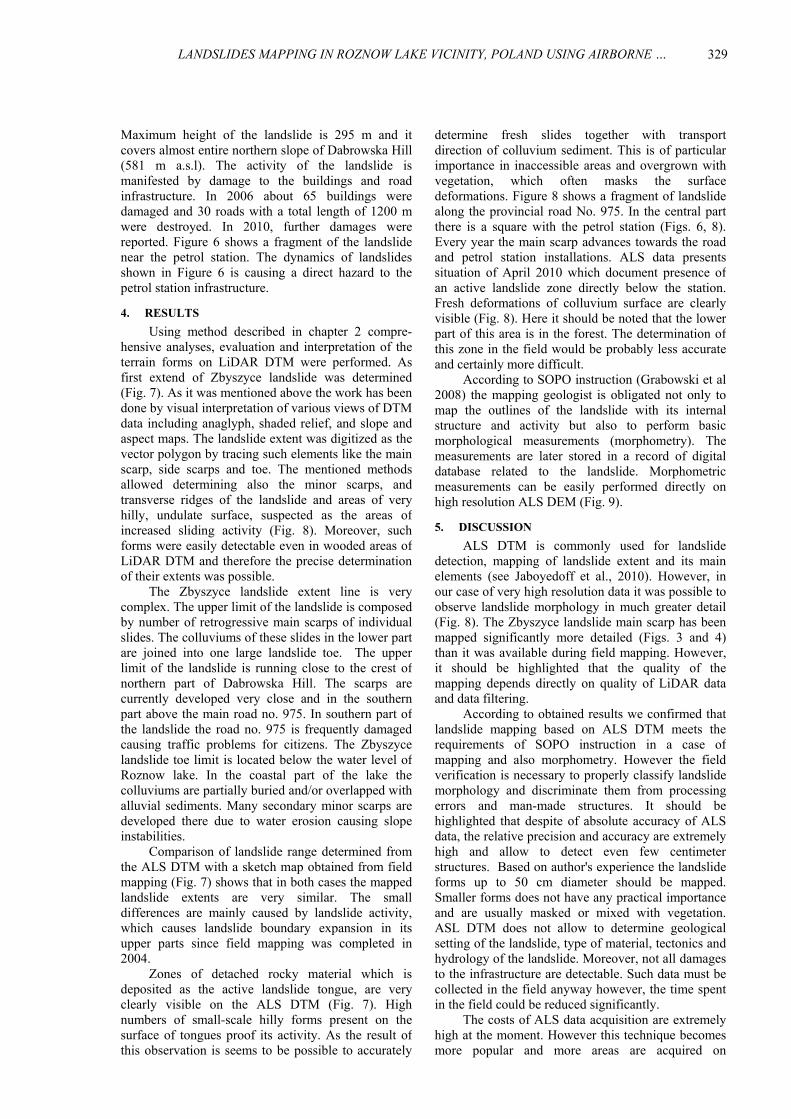
The method outlined above was used to filter the points cloud acquired in the first stage. It has been removed up to 45 % of points in forest areas, but still up to 6 points /m2 are remaining on the terrain surface. In agricultural land about 20% of points have been removed. The remaining point’s density was about 7 points /m2. A fragment of the LiDAR data set from Zbyszyce landslide region before and after filtering is shown in Figure 4. Comparison in Figures 3 and 4 highlights advantages of LiDAR technique to capture height data over the forested terrain.
Based on ALS data filtered DTM GRID model with a resolution of 0.5 m was interpolated using linear interpolation. The obtained DTM (Fig. 5) was then subjected to a detailed expert-based analysis for the landslide areas identification.
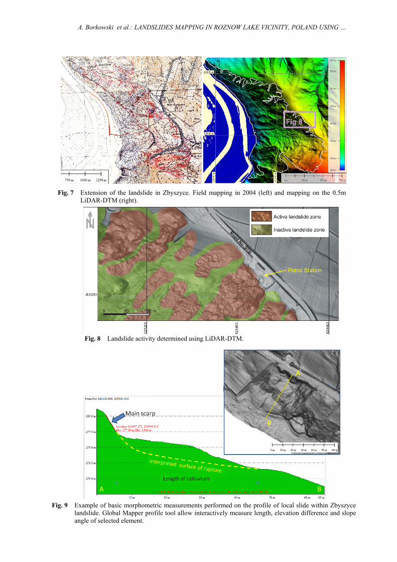
Within the next step the landslide LiDAR DTM analysis was carried out by applying the traditional approach of visual interpretation by experience geologists. Using various methods of DTM visualization, the landslide extent and its major elements were determined (Figs. 7, 8). Variable
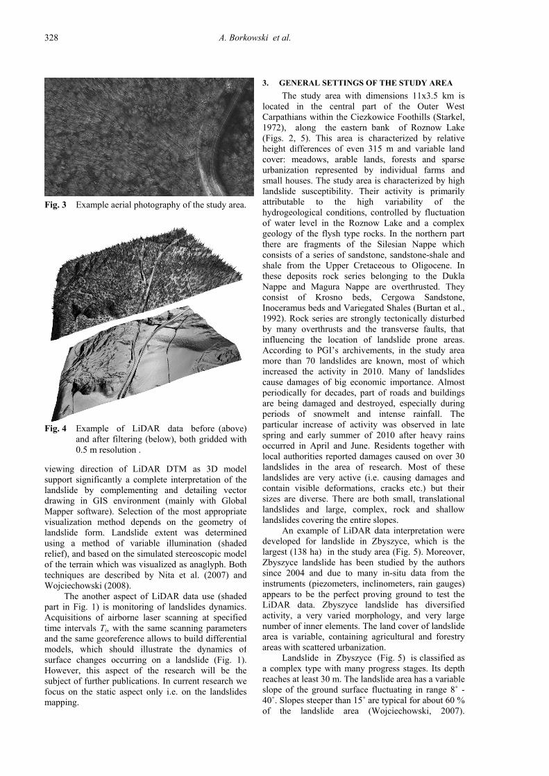
overlapping of the neighbour strips (of about 50 %)the resulted point clouds has the average point densityabout 7 points/m2. The density varies from 4 pointsnear the border of the study area to 9 points within thearea, reaching the maximum of about 11 points incrossing strips (see Fig. 2) The georeference wasafforded by RTK GPS measurements with correctionsfrom the permanent stations of ASG-EUPOS system.The basic technical data of applied ALS system weresummarised in Table 1. The absolute height accuracyof georeferenced points cloud was evaluated by 10cm. Simultaneously to ALS campaign, the digitalaerial images with terrain resolution of 10 cm were acquired. An example of such image from Zbyszycelandslide is presented in Figure 3. Despite the high-resolution and despite the fact that the deciduousforest dominates the area, the image is not useful formapping landslides and terrain forms are hidden underthe crowns of trees. About 10 % of the study area iscovered by forest. Moreover, about 59 % of the areaof analysed Zbyszyce landslide is forested. There aremixed and deciduous forests, but the last onedominates significantly.
The second most important stage after scanningis proper data filtering. The filtering stage is veryimportant because the resulted point cloud containsreflections that came not only from the bare ground but also from the land cover objects such as, e.g.buildings, trees. In forested areas, most reflectionscome from trees and low vegetation. For the landslidestudy purposes all of these points have to be removed.According to author’s experience, the most effectivefiltering was obtained using the method of activesurfaces model (Borkowski, 2004). This model isbased on the assumption that the active surface isattributed to internal and external “energy”. For themodelling we use the explicit representation of thesurface, ( , )z z x y= . The internal energy describes thegeometrical properties of surface:
2 2 2 2 2int ( ) ( 2 )
2 2x y xx xy yyE z z z z zα β= + + + +
A. Borkowski et al.
328
Fig. 3 Example aerial photography of the study area.
Fig. 4 Example of LiDAR data before (above)and after filtering (below), both gridded with 0.5 m resolution .
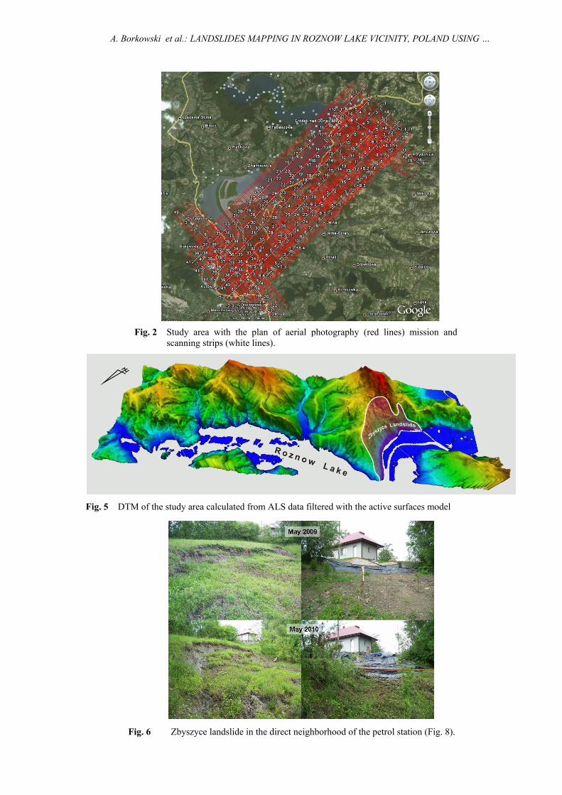
3. GENERAL SETTINGS OF THE STUDY AREA The study area with dimensions 11x3.5 km is
located in the central part of the Outer West Carpathians within the Ciezkowice Foothills (Starkel, 1972), along the eastern bank of Roznow Lake (Figs. 2, 5). This area is characterized by relative height differences of even 315 m and variable land cover: meadows, arable lands, forests and sparse urbanization represented by individual farms and small houses. The study area is characterized by high landslide susceptibility. Their activity is primarily attributable to the high variability of the hydrogeological conditions, controlled by fluctuation of water level in the Roznow Lake and a complex geology of the flysh type rocks. In the northern part there are fragments of the Silesian Nappe which consists of a series of sandstone, sandstone-shale and shale from the Upper Cretaceous to Oligocene. In these deposits rock series belonging to the Dukla Nappe and Magura Nappe are overthrusted. They consist of Krosno beds, Cergowa Sandstone, Inoceramus beds and Variegated Shales (Burtan et al., 1992). Rock series are strongly tectonically disturbed by many overthrusts and the transverse faults, that influencing the location of landslide prone areas. According to PGI’s archivements, in the study areamore than 70 landslides are known, most of whichincreased the activity in 2010. Many of landslides cause damages of big economic importance. Almost periodically for decades, part of roads and buildings are being damaged and destroyed, especially during periods of snowmelt and intense rainfall. The particular increase of activity was observed in late spring and early summer of 2010 after heavy rains occurred in April and June. Residents together with local authorities reported damages caused on over 30 landslides in the area of research. Most of these landslides are very active (i.e. causing damages and contain visible deformations, cracks etc.) but their sizes are diverse. There are both small, translationallandslides and large, complex, rock and shallow landslides covering the entire slopes.
An example of LiDAR data interpretation were developed for landslide in Zbyszyce, which is the largest (138 ha) in the study area (Fig. 5). Moreover, Zbyszyce landslide has been studied by the authors since 2004 and due to many in-situ data from the instruments (piezometers, inclinometers, rain gauges) appears to be the perfect proving ground to test the LiDAR data. Zbyszyce landslide has diversified activity, a very varied morphology, and very large number of inner elements. The land cover of landslide area is variable, containing agricultural and forestry areas with scattered urbanization.
Landslide in Zbyszyce (Fig. 5) is classified as a complex type with many progress stages. Its depth reaches at least 30 m. The landslide area has a variable slope of the ground surface fluctuating in range 8˚ -40˚. Slopes steeper than 15˚ are typical for about 60 % of the landslide area (Wojciechowski, 2007).
viewing direction of LiDAR DTM as 3D modelsupport significantly a complete interpretation of thelandslide by complementing and detailing vectordrawing in GIS environment (mainly with GlobalMapper software). Selection of the most appropriatevisualization method depends on the geometry oflandslide form. Landslide extent was determinedusing a method of variable illumination (shadedrelief), and based on the simulated stereoscopic modelof the terrain which was visualized as anaglyph. Bothtechniques are described by Nita et al. (2007) andWojciechowski (2008).
The another aspect of LiDAR data use (shadedpart in Fig. 1) is monitoring of landslides dynamics.Acquisitions of airborne laser scanning at specifiedtime intervals Ti, with the same scanning parametersand the same georeference allows to build differentialmodels, which should illustrate the dynamics ofsurface changes occurring on a landslide (Fig. 1).However, this aspect of the research will be thesubject of further publications. In current research wefocus on the static aspect only i.e. on the landslidesmapping.
LANDSLIDES MAPPING IN ROZNOW LAKE VICINITY, POLAND USING AIRBORNE ….
329
determine fresh slides together with transport
direction of colluvium sediment. This is of particular importance in inaccessible areas and overgrown with vegetation, which often masks the surface deformations. Figure 8 shows a fragment of landslide along the provincial road No. 975. In the central part there is a square with the petrol station (Figs. 6, 8). Every year the main scarp advances towards the road and petrol station installations. ALS data presents situation of April 2010 which document presence of an active landslide zone directly below the station. Fresh deformations of colluvium surface are clearly visible (Fig. 8). Here it should be noted that the lower part of this area is in the forest. The determination of this zone in the field would be probably less accurate and certainly more difficult.
According to SOPO instruction (Grabowski et al 2008) the mapping geologist is obligated not only to map the outlines of the landslide with its internal structure and activity but also to perform basic morphological measurements (morphometry). The measurements are later stored in a record of digital database related to the landslide. Morphometric measurements can be easily performed directly on high resolution ALS DEM (Fig. 9).
5. DISCUSSION
ALS DTM is commonly used for landslide detection, mapping of landslide extent and its main elements (see Jaboyedoff et al., 2010). However, in our case of very high resolution data it was possible to observe landslide morphology in much greater detail (Fig. 8). The Zbyszyce landslide main scarp has been mapped significantly more detailed (Figs. 3 and 4) than it was available during field mapping. However, it should be highlighted that the quality of the mapping depends directly on quality of LiDAR data and data filtering.
According to obtained results we confirmed that landslide mapping based on ALS DTM meets the requirements of SOPO instruction in a case of mapping and also morphometry. However the field verification is necessary to properly classify landslide morphology and discriminate them from processing errors and man-made structures. It should be highlighted that despite of absolute accuracy of ALS data, the relative precision and accuracy are extremely high and allow to detect even few centimeter structures. Based on author's experience the landslide forms up to 50 cm diameter should be mapped. Smaller forms does not have any practical importance and are usually masked or mixed with vegetation. ASL DTM does not allow to determine geological setting of the landslide, type of material, tectonics and hydrology of the landslide. Moreover, not all damages to the infrastructure are detectable. Such data must be collected in the field anyway however, the time spent in the field could be reduced significantly.
The costs of ALS data acquisition are extremely high at the moment. However this technique becomes more popular and more areas are acquired on
Maximum height of the landslide is 295 m and it covers almost entire northern slope of Dabrowska Hill(581 m a.s.l). The activity of the landslide ismanifested by damage to the buildings and roadinfrastructure. In 2006 about 65 buildings weredamaged and 30 roads with a total length of 1200 mwere destroyed. In 2010, further damages were reported. Figure 6 shows a fragment of the landslidenear the petrol station. The dynamics of landslides shown in Figure 6 is causing a direct hazard to thepetrol station infrastructure.
4. RESULTS
Using method described in chapter 2 compre-hensive analyses, evaluation and interpretation of theterrain forms on LiDAR DTM were performed. Asfirst extend of Zbyszyce landslide was determined(Fig. 7). As it was mentioned above the work has beendone by visual interpretation of various views of DTM data including anaglyph, shaded relief, and slope andaspect maps. The landslide extent was digitized as thevector polygon by tracing such elements like the mainscarp, side scarps and toe. The mentioned methodsallowed determining also the minor scarps, andtransverse ridges of the landslide and areas of veryhilly, undulate surface, suspected as the areas ofincreased sliding activity (Fig. 8). Moreover, suchforms were easily detectable even in wooded areas ofLiDAR DTM and therefore the precise determinationof their extents was possible.
The Zbyszyce landslide extent line is verycomplex. The upper limit of the landslide is composedby number of retrogressive main scarps of individualslides. The colluviums of these slides in the lower part are joined into one large landslide toe. The upperlimit of the landslide is running close to the crest ofnorthern part of Dabrowska Hill. The scarps arecurrently developed very close and in the southernpart above the main road no. 975. In southern part of the landslide the road no. 975 is frequently damagedcausing traffic problems for citizens. The Zbyszycelandslide toe limit is located below the water level ofRoznow lake. In the coastal part of the lake thecolluviums are partially buried and/or overlapped withalluvial sediments. Many secondary minor scarps aredeveloped there due to water erosion causing slopeinstabilities.
Comparison of landslide range determined fromthe ALS DTM with a sketch map obtained from fieldmapping (Fig. 7) shows that in both cases the mappedlandslide extents are very similar. The smalldifferences are mainly caused by landslide activity,which causes landslide boundary expansion in itsupper parts since field mapping was completed in2004.
Zones of detached rocky material which isdeposited as the active landslide tongue, are veryclearly visible on the ALS DTM (Fig. 7). Highnumbers of small-scale hilly forms present on thesurface of tongues proof its activity. As the result ofthis observation is seems to be possible to accurately
A. Borkowski et al.
330
window. Proceedings of. LXIII Meeting of PTG, Koninki, 171–179, (in Polish).
Carter,W., Shrestha, R., Tuell, D., Bloomquist, D. and Sartori, M.: 2001, Airborne laser swath mapping shines new light on earth’s topography. Eos, Trans, Am Geophys Union 82(46), 549, 550, 555.
Chigira, M., Duan, F., Yagi, H. and Furuya, T.: 2004, Using an airborne laser scanner for the identification of shallow landslides and susceptibility assessment in an area of ignimbrite overlain by permeable pyroclastics. Landslides 1, 203–209.
Gołuch, P., Borkowski, A. and Jóźków, G.: 2008, The accuracy of the interpolated DTM based on airborne laser scanning of ScaLARS system. Acta ScientiarumPolonorum seria Geodesia et Dercriptio Terrarum, (7)2, 37–47, (in Polish).
Grabowski, D.: 2008, Landslide counteracting system SOPO. Przegląd Geologiczny, 56, 537–538, (in Polish)
Grabowski, D., Marciniec, P., Mrozek, T., Neścieruk, P., Rączkowski, W. and Zimnal, Z.: 2008, Instruction to develop maps of landslides and landslide-prone areas in the scale 1:10 000 Polish Geological Institute, Warszawa, 92 pp., (in Polish).
Haugerud, R.A., Harding, D.J., Johnson, S.Y., Harless, J.L., Weaver, C.S. and Sherrod, B.L.: 2003 High-resolution lidar topography of the Puget Lowland, Washington-A Bonanza for earth science. GSA Today 13:4–10.
Jaboyedoff, M., Oppikofer, T., Abellán, A., Derron, M.H., Loye, A., Metzger, R. and Pedrazzini, A.: 2010, Use of LIDAR in landslide investigations: a review. Nat Hazards. doi:10.1007/s11069-010-9634-2
Nita, J., Małolepszy, Z. and Chybiorz, R.: 2007, The use of digital elevation model to visualize the terrain morphology and geological interpretation. Przegląd Geologiczny, 55, 511–520, (in Polish).
Poprawa, D. and Rączkowski, W.: 2003, Landslides of Carpathians. (in Polish) Przegląd Geologiczny, 51 (8), 685–692.
Preuss, R. and Kurczyński, Z.: 2002: Polish orthophoto production concept for the Land Parcel Identification System - LPIS. Opportunity and challenge. Geodeta, 8, (87), (in Polish).
Razak, K. A., Straatsma, M.W., van Westen, C. J., Malet, J.-P. and de Jong, S.M.: 2011, Airborne laser scanning of forested landslides characterization: Terrain model quality and visualization. Geomorphology, 126, 186–200.
Schulz, W.H.: 2007, Landslide susceptibility revealed by LIDAR imagery and historical records, Seattle, Washington, Engineering Geology, 89, 67–87.
Sekiguchi, T. and Sato, H.P: 2004, Mapping of micro topography using airborne laser scanning. Landslides1, 195–202.
Starkel, L.: 1972 – Characteristics of relief of the Polish Carpathians and their significance for the human economy. (in Polish) Problemy Zagospodarowania Ziem Górskich, 10, 75–150.
Wojciechowski, T.: 2007, Zbyszyce Landslide (in Polish) Prace Naukowe Instytutu Górnictwa Politechniki Wrocławskiej, 120(49): 315–324.
Wojciechowski, T.: 2008, Altitude numerical terrain model (DTM) in a landslide research. (in Polish) Prace Wydziału Nauk o Ziemi Uniwersytetu Śląskiego nr 54, 96–102.
governmental level. The costs of field work forlandslide mapping is also very high and for complexareas it could be comparable with ALS dataacquisition, processing and interpretation and the timerequired to complete the maps is considerably shorter.
6. CONCLUSIONS AND FUTURE WORK Preliminary results presented in this work show
the first stage of an ongoing research carried out on landslides in Roznow Lake vicinity. In this first stageLiDAR data were acquired using modern laserscanning system. Then, acquired point cloud wasfiltered using the active surfaces model method toobtain detailed and precise DTM. The resulted DTMproved to be a reliable and valuable product forlandslides mapping and interpretation. Particularly,the detailed interpretation of such precise DTM allowsfor: • landslides extent identification, especially in
difficult areas e.g. forestry areas, • identification of internal landslides forms, • determination of landslide activity, • measurement of basic morphometric parameters.
Finally it can be concluded that the LiDAR DTMappears to be a significant support for geologicalinterpretation and landslide detection especially onsteep and forested slopes. It can be recommended touse it for the purposes of landslide mapping withinSOPO project.
Further studies will be focused on potentials ofusing the ALS technique for the landslides dynamicsmonitoring. To perform that, the second ALS dataacquisition campaign is planned.
ACKNOWLEDGEMENT
The research presented in this work was fundedby Polish Ministry of Science and Higher Educationfrom founds on science in 2009-2012 as a researchproject number N N526 146037. This work has beenalso partially supported by the Wroclaw Centre ofNetworking and Supercomputing, computational grantusing Matlab Software License No: 101979
REFERENCES Ackermann, F.: 1999, Airborne laser scanning - present
status and future expectations. ISPRS Journal ofPhotogrammetry & Remote Sensing 54 1999, 64–67.
Baldo, M., Bicocchi, C., Chiocchini, U., Giordan, D. andLollino, G.: 2009, LiDAR monitoring of mass wastingprocesses: The Radicofani landslide, Province ofSiena, Central Italy. Geomorphology 10, 193–201.
Borkowski, A.: 2004, Modellierung von Oberflächen mitDiskontinuitäten. Deutsche Geodätische Kommission.München, Reihe C, Heft 575, 91 pp.
Borkowski, A. and Jóźków, G.: 2008, Airborne laser scanning data filtering using flakes. The International Archives of the Photogrammetry, Remote Sensing andSpatial Information Sciences, Vol. XXXVII, Part B3b,179–184.
Burtan, J., Cieszkowski, M., Jawor, E. and Ślączka, A.:1992, Geology of Klęczany – Limanowa tectonic
A. Borkowski et al.: LANDSLIDES MAPPING IN ROZNOW LAKE VICINITY, POLAND USING ….
Fig. 2 Study area with the plan of aerial photography (red lines) mission and scanning strips (white lines).
Fig. 5 DTM of the study area calculated from ALS data filtered with the active surfaces model
Fig. 6 Zbyszyce landslide in the direct neighborhood of the petrol station (Fig. 8).
A. Borkowski et al.: LANDSLIDES MAPPING IN ROZNOW LAKE VICINITY, POLAND USING ….
Fig. 9 Example of basic morphometric measurements performed on the profile of local slide within Zbyszyce landslide. Global Mapper profile tool allow interactively measure length, elevation difference and slopeangle of selected element.
Fig. 8 Landslide activity determined using LiDAR-DTM.
Fig. 7 Extension of the landslide in Zbyszyce. Field mapping in 2004 (left) and mapping on the 0.5m LiDAR-DTM (right).